Day
Ostheim vor der Rhön, Deutschland
50° 27' 38.9" N 10° 13' 49.8" E
50.4608058 10.2305055
• Head east on Friedenstraße. Go for 239 m.
• Continue on Friedenstraße. Go for 134 m.
• Continue on Krankenhausstraße. Go for 124 m.
• Turn left onto Paulinenstraße (B285). Go for 10.5 km.
• Take ramp onto A71 toward Schweinfurt/Würzburg. Go for 50.2 km.
• Take left exit 31 toward Bayreuth/Bamberg/Nürnberg/Schweinfurt onto A70. Go for 59.0 km.
• Take exit 17 toward Nürnberg onto A73. Go for 45.9 km.
• Take the exit toward Regensburg/München/N.-Flughafen/N.-Hafen/N.-Messe/N.-Stadion onto A3. Go for 21.7 km.
• Keep left onto E45 (Autobahnkreuz Nürnberg) toward München/Heilbronn/N.-Hafen/N.-Messe/N.-Stadion/A9. Go for 2.4 km.
• Continue on A9. Go for 149 km.
• Take the exit toward Salzburg/Innsbruck/Messe/ICM onto A99. Go for 29.3 km.
• Take exit 21 toward Salzburg/Innsbruck onto A8. Go for 117 km.
• Continue on A1 (West Autobahn). Go for 2.1 km.
• Take the exit toward Ljubljana/Villach/Salzburg-Süd onto A10 (Tauern Autobahn). Go for 65.4 km.
• Take exit 66 toward Flachau. Go for 731 m.
• Take the 3rd exit from roundabout onto Flachauer Straße (L230) toward Flachau. Go for 1.1 km.
• Arrive at Flachauer Straße (L230). Your destination is on the left.
☍
553,8 km
(4 hrs. 50 min.)
Alter Jagdhof Flachau
Free parking space along the route, it was quiet, so everything was fine.
Since our motorhome weighs over 3.5 tons and we were slightly annoyed/overwhelmed by the toll system in Austria, we drove over the passes off the beaten track. Conclusion: Exciting route, but you lose a lot of time. So rather spend money and pay the toll..
Feuersang 104, 5542, Flachau, Österreich
47° 21' 12" N 13° 23' 39" E
47.3533333 13.3941667
• Head toward Hundsdorfgasse on Flachauer Straße (L230). Go for 30 m.
• Continue on Feuersang (L230). Go for 1.0 km.
• Take the 1st exit from roundabout onto A10 (Tauern Autobahn) toward Villach. Go for 117 km.
• Continue on A11 (Karawanken Autobahn). Go for 21.7 km.
• Continue on Predor Karavanke (A2). Go for 71.0 km.
• Take exit 36 toward Trst/Trieste/Koper/Postojna/Reka/Rijeka onto A1. Go for 94.7 km.
• Continue on H5. Go for 3.7 km.
• Take ramp onto Ljubljanska cesta (11) toward Pulj/Pula/Pola/Poreč/Šmarje. Go for 1.1 km.
• Keep right toward Pulj/Pola/Pula/Dragonja/Dragogna. Go for 17 m.
• Pass 2 roundabouts and continue on Srgaši (11). Go for 13.3 km.
• Continue on Dragonja (11). Go for 514 m.
• Continue on 510. Go for 1.8 km.
• Take the 2nd exit from roundabout onto Istarski Ipsilon (A9) toward Rijeka/Fiume/Pula/Pola/Umag/Umago/Poreč. Go for 27.2 km.
• Take exit 4 toward Motovun/Montona/Poreč sjever/Parenzo nord/Višnjan/Visignano. Go for 886 m.
• Turn right onto Farini (5042) toward Poreč. Go for 6.3 km.
• Take the 3rd exit from roundabout onto Primorska ulica (5042) toward Poreč. Go for 1.1 km.
• Take the 3rd exit from roundabout onto 75 toward Vrsar/Orsera/Funtana/Fontane. Go for 2.6 km.
• Pass 4 roundabouts and continue on 75. Go for 6.6 km.
• Continue on Istarska (75) toward Vrsar/Koversada/Funtana. Go for 255 m.
• Take the 1st exit from roundabout onto Put Perila. Go for 69 m.
• Turn slightly right onto Coki. Go for 200 m.
• Turn slightly left onto Coki. Go for 34 m.
• Arrive at Coki. Your destination is on the right.
☍
371,2 km
(3 hrs. 42 min.)
Day
Camping Puntica
The place is beautifully located, right next to the port of Funtana. Funtana itself is more of a holiday resort without much historical flair but with a few restaurants and many holiday apartments. We didn't get to Porec, because it's a couple of kilometers by bike, our toddlers couldn't manage that much, but 6km shouldn't be a problem for adults.
Conclusion: Recommended for a quiet start
Puntica 1, 52440, Funtana - Poreč, Kroatien
45° 10' 38" N 13° 36' 12.1" E
45.1772200 13.6033700
• Head south on Coki. Go for 84 m.
• Turn right onto Coki. Go for 38 m.
• Turn right onto Coki. Go for 15 m.
• Turn left onto Coki. Go for 285 m.
• Turn slightly left onto Put Perila. Go for 53 m.
• Take the 3rd exit from roundabout onto Istarska (75). Go for 328 m.
• Continue on 75. Go for 2.5 km.
• Take the 2nd exit from roundabout onto 75. Go for 1.7 km.
• Take the 3rd exit from roundabout toward Poreč/Parenzo. Go for 1.2 km.
• Continue on Ulica Karla Huguesa. Go for 598 m.
• Pass 2 roundabouts and continue on Ulica Karla Huguesa. Go for 871 m.
• Take the 1st exit from roundabout onto Obala maršala Tita. Go for 274 m.
• Take the 2nd exit from roundabout onto Narodni trg. Go for 56 m.
• Turn right onto Ulica Frane Glavinića. Go for 52 m.
• Arrive at Ulica Frane Glavinića. Your destination is on the right.
☍
8,0 km
( 10 min.)
Day
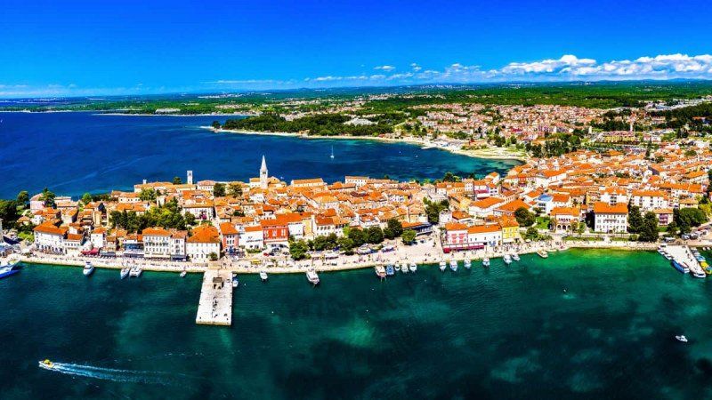
Poreč
Poreč, Kroatien
45° 13' 37.8" N 13° 35' 41.1" E
45.2271652 13.5947399
• Head toward Narodni trg on Ulica Frane Glavinića. Go for 52 m.
• Turn left onto Narodni trg. Go for 27 m.
• Take the 1st exit from roundabout onto Obala maršala Tita. Go for 282 m.
• Take the 2nd exit from roundabout onto Ulica Karla Huguesa. Go for 270 m.
• Take the 3rd exit from roundabout onto Ulica županije Somogy. Go for 346 m.
• Take the 3rd exit from roundabout onto Partizanska ulica. Go for 132 m.
• Take the 1st exit from roundabout. Go for 120 m.
• Turn sharp left onto Ulica Mlinska. Go for 60 m.
• Turn right onto Ulica Otokara Keršovanija. Go for 76 m.
• Turn right onto Ulica Otokara Keršovanija. Go for 102 m.
• Turn right onto Ulica P. Budičina. Go for 9 m.
• Turn left onto Obala dr. Ante Šonje. Go for 125 m.
• Arrive at Obala dr. Ante Šonje.
☍
1,6 km
( 4 min.)
Eufrazijeva bazilika
Eufrazijeva ul., 52440, Poreč, Kroatien
45° 13' 43.1" N 13° 35' 36.5" E
45.2286337 13.5934783
• Head toward Ulica P. Budičina on Obala dr. Ante Šonje. Go for 125 m.
• Turn left onto Ulica Nikole Tesle. Go for 239 m.
• Take the 2nd exit from roundabout. Go for 135 m.
• Take the 1st exit from roundabout onto Ulica županije Somogy. Go for 152 m.
• Take the 2nd exit from roundabout onto Ulica županije Somogy toward Centar. Go for 144 m.
• Turn left onto Vukovarska ulica toward Pula/Pazin. Go for 292 m.
• Pass 2 roundabouts and continue on Vukovarska ulica (302). Go for 1.4 km.
• Continue on Porečka ulica (302). Go for 298 m.
• Take the 2nd exit from roundabout onto Porečka ulica (302) toward Rijeka/Fiume/Pula/A9/Pola/Pazin. Go for 5.0 km.
• Turn right onto Radmani (5072) toward Dračevac. Go for 179 m.
• Continue on 5072. Go for 2.4 km.
• Continue on Šušnjići (5072). Go for 265 m.
• Continue on 5072. Go for 3.0 km.
• Turn right onto Ulica Limska (5209) toward Pula/Rovinj/Limski kanal. Go for 124 m.
• Take the 2nd exit from roundabout onto Ulica Limska (5209). Go for 3.3 km.
• Continue on 5209. Go for 1.5 km.
• Continue on 75 toward Rovinj/Rovigno/Bale/Valle. Go for 5.3 km.
• Turn right and take ramp toward Rovinj. Go for 258 m.
• Turn right onto 303 toward Rovinj. Go for 1.4 km.
• Continue on Putini (303). Go for 607 m.
• Continue on 303. Go for 5.9 km.
• Continue on Aleja Ruđera Boškovića (303). Go for 482 m.
• Take the 3rd exit from roundabout onto Aleja Ruđera Boškovića (303) toward Rovinj sjever/Rovigno nord. Go for 1.1 km.
• Take the 1st exit from roundabout onto Aleja Ruđera Boškovića (303) toward Rovinj sjever/Rovigno nord/Centar/Centro. Go for 719 m.
• Take the 1st exit from roundabout onto Ulica Concetta (5095) toward Rovinj sjever/Rovigno nord/Bolnica/Ospedale. Go for 521 m.
• Continue on Porton Biondi (5095). Go for 327 m.
• Turn slightly right onto Porton Biondi. Go for 55 m.
• Arrive at Porton Biondi. Your destination is on the right.
☍
35,2 km
( 37 min.)
Day
Camping Porton Biondi
Aleja Porton Biondi 1, 52210, Rovinj, Kroatien
45° 5' 43.4" N 13° 38' 30.3" E
45.0953900 13.6417500
• Head south on Porton Biondi. Go for 55 m.
• Turn slightly left onto Porton Biondi (5095). Go for 327 m.
• Continue on Ulica Concetta (5095). Go for 510 m.
• Take the 2nd exit from roundabout onto Vijenac Franje Glavinića. Go for 769 m.
• Turn left onto Vijenac braće Lorenzetto. Go for 250 m.
• Turn right onto Istarska ulica toward Centar/Centro. Go for 93 m.
• Turn slightly left onto Ulica Giosue Carduccija. Go for 169 m.
• Arrive at Ulica Giosue Carduccija. Your destination is on the right.
☍
2,2 km
( 4 min.)
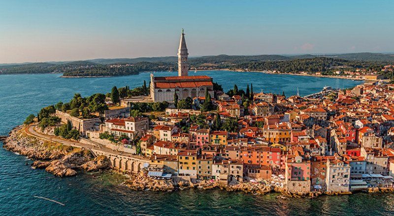
Rovinj
Rovinj, Kroatien
45° 4' 52.2" N 13° 38' 19.3" E
45.0811661 13.6387067
• Head toward Ulica Carera on Ulica Giosue Carduccija. Go for 23 m.
• Continue on Trg na lokvi. Go for 11 m.
• Turn slightly left onto Trg na lokvi. Go for 6 m.
• Turn left onto Trg na lokvi. Go for 26 m.
• Continue on Ulica Mattea Benussia. Go for 222 m.
• Turn left onto Vijenac braće Lorenzetto. Go for 103 m.
• Turn right onto Istarska ulica (5096). Go for 245 m.
• Pass 2 roundabouts and continue on Istarska ulica (5096). Go for 623 m.
• Take the 3rd exit from roundabout onto Ulica braće Božić (5096) toward Pula/Pola/Bale/Valle. Go for 280 m.
• Continue on 5096. Go for 599 m.
• Take the 2nd exit from roundabout onto Naselje Monfiorenzo (5096) toward Pula/Pola/Bale/Valle. Go for 284 m.
• Continue on 5096. Go for 679 m.
• Continue on Rato Di Ren (5096). Go for 834 m.
• Continue on 5096. Go for 1.2 km.
• Continue on Kokuletovica (5096). Go for 425 m.
• Continue on Naselje Cocaletto (5096). Go for 303 m.
• Continue on 5096. Go for 1.2 km.
• Continue on Španidiga (5096). Go for 800 m.
• Continue on 5096. Go for 5.3 km.
• Take the 2nd exit from roundabout onto 5096. Go for 1.1 km.
• Turn right onto 75. Go for 8.2 km.
• Turn right onto 75 toward Pula/Fažana/Vodnjan. Go for 712 m.
• Take the 2nd exit from roundabout onto 75 toward Pula. Go for 720 m.
• Continue on Ulica Giovannia A. Della Zonca (75). Go for 119 m.
• Continue on 75. Go for 736 m.
• Keep right onto 75. Go for 157 m.
• Continue on Ulica 1. maja (75). Go for 107 m.
• Continue on 75 toward Pula. Go for 197 m.
• Pass 5 roundabouts and continue on Vodnjanska cesta (75). Go for 7.7 km.
• Take the 1st exit from roundabout onto Tršćanska ulica (400) toward Centar/Željeznički kolodvor. Go for 1.1 km.
• Take the 2nd exit from roundabout onto Ulica starih statuta (400) toward Stoja/Centar. Go for 327 m.
• Take the 2nd exit from roundabout onto Riva. Go for 498 m.
• Continue on Flaciusova ulica. Go for 761 m.
• Turn right onto Arsenalska ulica toward Stoja/Verudela. Go for 551 m.
• Turn right onto Bečka ulica toward Slobodna zona. Go for 260 m.
• Continue on Ulica Katalinića Jeretova. Go for 810 m.
• Continue on Ulica Stoja. Go for 207 m.
• Pass 2 roundabouts and continue on Ulica Stoja. Go for 1.2 km.
• Turn sharp right onto Ulica Stoja. Go for 39 m.
• Turn right. Go for 49 m.
• Arrive at your destination on the right.
☍
38,6 km
( 43 min.)
Day
Day
Arena Stoja Campsite
Stoja 37, 52100, Pula, Kroatien
44° 51' 34.1" N 13° 48' 50.5" E
44.8594600 13.8140200
• Head northeast. Go for 49 m.
• Turn left onto Ulica Stoja. Go for 56 m.
• Take the 1st exit from roundabout onto Ulica Stoja. Go for 1.0 km.
• Take the 2nd exit from roundabout onto Ulica Stoja. Go for 245 m.
• Turn right onto Ulica Katalinića Jeretova. Go for 810 m.
• Continue on Bečka ulica. Go for 245 m.
• Turn left onto Arsenalska ulica toward Centar. Go for 581 m.
• Turn right onto Dobrilina ulica toward Rijeka/A8/A9/Koper. Go for 347 m.
• Turn sharp left onto Dalmatinova ulica. Go for 43 m.
• Arrive at Dalmatinova ulica. Your destination is on the right.
☍
3,4 km
( 6 min.)
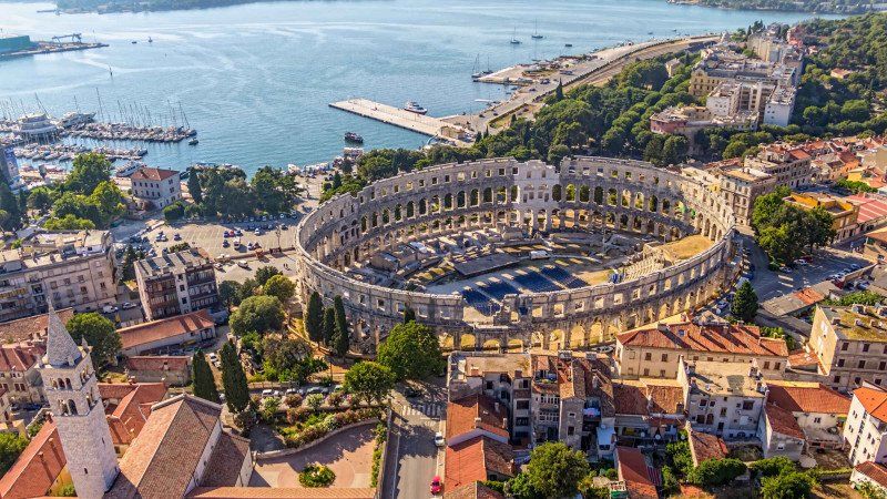
Pula
Pula, Kroatien
44° 51' 59.8" N 13° 50' 58.5" E
44.8666232 13.8495788
• Head toward Švalbina ulica on Dalmatinova ulica. Go for 74 m.
• Continue on Smareglina ulica. Go for 136 m.
• Turn right onto Laginjina ulica. Go for 87 m.
• Continue on Giardini ulica. Go for 128 m.
• Continue on Giardini ulica. Go for 93 m.
• Continue on Istarska ulica. Go for 156 m.
• Turn slightly right onto Scalierova ulica. Go for 227 m.
• Turn slightly left onto Ozad Arene. Go for 42 m.
• Arrive at Ozad Arene. Your destination is on the left.
☍
0,9 km
( 2 min.)
Amphitheater Pula, Flavijevska ulica, Pula, Kroatien
Flavijevska ul., 52100, Pula, Kroatien
44° 52' 23.6" N 13° 51' 0.9" E
44.8732299 13.8502458
• Head north on Ozad Arene. Go for 73 m.
• Turn right onto Faverijska ulica. Go for 134 m.
• Turn right onto Teslina ulica. Go for 81 m.
• Turn left onto Stiglicheva ulica. Go for 95 m.
• Turn right onto Rakovčeva ulica. Go for 455 m.
• Continue on Mletačka ulica. Go for 274 m.
• Continue on Trg Republike. Go for 79 m.
• Turn right onto Dalmatinova ulica. Go for 204 m.
• Continue on Smareglina ulica. Go for 136 m.
• Continue on Anticova ulica. Go for 264 m.
• Continue on Flaciusova ulica toward Kopar/Rijeka. Go for 25 m.
• Arrive at Flaciusova ulica. Your destination is on the right.
☍
1,8 km
( 4 min.)
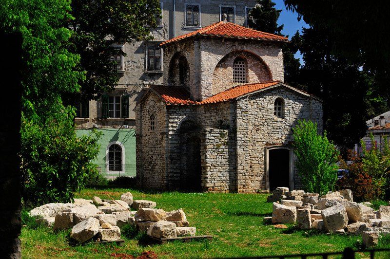
Bazilika Sv. Marija Formoza
Maksimijanova ul. 14, 52100, Pula, Kroatien
44° 52' 4.7" N 13° 50' 37.1" E
44.8679771 13.8436488
• Head northwest on Flaciusova ulica. Go for 614 m.
• Continue on Riva. Go for 461 m.
• Take the 1st exit from roundabout onto Ulica starih statuta (400). Go for 331 m.
• Take the 1st exit from roundabout onto Ulica 43. istarske divizije toward Labin/Zračna luka. Go for 845 m.
• Take the 2nd exit from roundabout onto Ulica 43. istarske divizije toward Rijeka/Koper/Zračna luka. Go for 330 m.
• Take the 2nd exit from roundabout onto Šijanska cesta (66) toward Rijeka/Umag/Umago/Labin/Zračna luka. Go for 723 m.
• Keep right toward Šijanska cesta/66. Go for 35 m.
• Take the 2nd exit from roundabout onto Šijanska cesta (66) toward Rijeka/A9/Fiume/Labin/Zračna luka. Go for 1.2 km.
• Keep right toward Rijeka/Fiume/E751/A9/Labin/Medulin/Zračna luka. Go for 24 m.
• Take the 2nd exit from roundabout onto Šijanska cesta (66) toward Rijeka/Fiume/A9/Labin/Zračna luka. Go for 525 m.
• Take ramp onto A9 (Istarski Ipsilon) toward Rijeka/Fiume/Umag/Umago/E751. Go for 64.8 km.
• Take exit 3 toward Buzet/Nova Vas/Villanova/Novigrad/Cittanova/300. Go for 426 m.
• Turn left onto 44 toward Buzet/Nova Vas/Villanova. Go for 11.2 km.
• Take the 3rd exit from roundabout onto 5209 toward Buje/Buie. Go for 3.7 km.
• Turn right onto Raskršće toward Grožnjan/Šaltarija. Go for 362 m.
• Continue on Šaltarija. Go for 1.1 km.
• Continue on Peroj. Go for 481 m.
• Turn left onto Vrh Roman. Go for 333 m.
• Continue on Stanica. Go for 28 m.
• Continue on Stanica (5008). Go for 212 m.
• Keep right onto 5008. Go for 279 m.
• Continue on Bujska cesta (5008). Go for 278 m.
• Turn left onto Motovunska ulica (5008). Go for 7 m.
• Arrive at Motovunska ulica (5008). Your destination is on the right.
☍
88,3 km
(1 hrs. 2 min.)
Day
Day
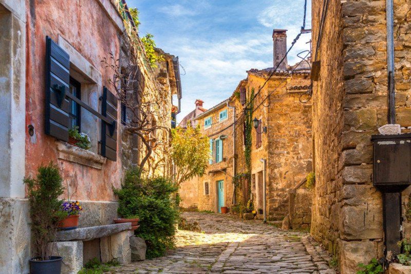
Grožnjan
52429, Grožnjan, Kroatien
45° 22' 46.6" N 13° 43' 21.4" E
45.3796024 13.7226113
• Head toward Vinska cesta on Motovunska ulica (5008). Go for 236 m.
• Continue on 5008. Go for 1.8 km.
• Continue on Flegi (5008). Go for 63 m.
• Continue on 5008. Go for 1.3 km.
• Continue on Koče (5008). Go for 213 m.
• Continue on 5008. Go for 822 m.
• Turn left onto 5209. Go for 525 m.
• Take the 3rd exit from roundabout onto 44 toward Buzet/Pinguente. Go for 22.6 km.
• Take the 1st exit from roundabout onto Riječka ulica (44). Go for 1.4 km.
• Take the 1st exit from roundabout onto Naselje sveti Ivan (44). Go for 7.3 km.
• Turn right onto 50038 toward Hum/Brnobići/Forčići. Go for 717 m.
• Continue on Lušići (50038). Go for 544 m.
• Turn slightly right onto 50038. Go for 157 m.
• Turn left onto 50038. Go for 1.3 km.
• Continue on Brnobići (50038). Go for 473 m.
• Turn slightly left onto 50038. Go for 30 m.
• Continue on Brnobići (50038). Go for 555 m.
• Continue on 50038. Go for 169 m.
• Turn slightly right onto 50038. Go for 196 m.
• Continue on Brnobići (50038). Go for 425 m.
• Continue on 50038. Go for 1.5 km.
• Continue on Hum (50038). Go for 56 m.
• Continue on Hum. Go for 160 m.
• Arrive at Hum. Your destination is on the right.
☍
42,4 km
( 49 min.)
Hum
52425, Hum, Kroatien
45° 20' 56.8" N 14° 2' 57.8" E
45.3491241 14.0493960
• Head northwest on Hum. Go for 160 m.
• Turn sharp right onto Hum (50038). Go for 227 m.
• Continue on 50038. Go for 717 m.
• Turn right onto 50038. Go for 873 m.
• Turn left onto 50038. Go for 267 m.
• Continue on Erkovčići (50038). Go for 430 m.
• Continue on 50038. Go for 259 m.
• Continue on Stancija (50038). Go for 309 m.
• Turn right onto 50038. Go for 385 m.
• Turn left onto 50082 toward Lupoglav. Go for 178 m.
• Continue on Lesišćina (50082). Go for 132 m.
• Continue on Mrzlići (50082). Go for 520 m.
• Continue on Bašići (50082). Go for 592 m.
• Continue on Silonji (50082). Go for 338 m.
• Continue on 50082. Go for 864 m.
• Continue on Barbići (50082). Go for 282 m.
• Turn left onto Vidići (50084). Go for 170 m.
• Continue on Lupoglav (50084). Go for 102 m.
• Turn left and take ramp onto A8 (Istarski Ipsilon) toward Rijeka. Go for 6.3 km.
• Keep left onto Istarski Ipsilon (A8). Go for 17.0 km.
• Continue toward Istarski Ipsilon/A8. Go for 31 m.
• Take the 2nd exit from roundabout onto Istarski Ipsilon (A8). Go for 685 m.
• Take ramp onto Autocesta Rupa-Rijeka (A7) toward Split/Zagreb/Rijeka/E65. Go for 12.2 km.
• Take ramp onto Orehovica (A6) toward Zagreb/Split. Go for 78.5 km.
• Take exit 1 toward Split/Senj/Ogulin onto A1 (Autocesta Bosiljevo-Split-Dubrov.). Go for 19.8 km.
• Take exit 8 toward Bjelolasica/Josipdol/Ogulin/23. Go for 830 m.
• Take ramp toward Josipdol/Oštarije. Go for 636 m.
• Turn left onto Oštarije (42) toward Plitvička jezera. Go for 5.5 km.
• Keep left onto Senjska (23) toward Senj/Plaški/Plitvička jezera. Go for 1.1 km.
• Turn left onto Munjava (42). Go for 52.6 km.
• Turn sharp right onto 429 toward Split/Zadar. Go for 10.3 km.
• Turn right onto Jezerce. Go for 11 m.
• Arrive at Jezerce. Your destination is on the left.
☍
212,3 km
(2 hrs. 57 min.)
Day
Stellplatz Cvetkovic
Jezerce 28, 53231, Plitvička Jezera, Kroatien
44° 51' 50" N 15° 38' 29" E
44.8638889 15.6413889
• Head east on Jezerce. Go for 11 m.
• Turn right onto Jezerce (429). Go for 2.3 km.
• Turn right toward Plitvički Ljeskovac. Go for 7.4 km.
• Turn slightly left onto Plitvički Ljeskovac. Go for 893 m.
• Turn right onto Plitvički Ljeskovac. Go for 4.5 km.
• Arrive at your destination.
☍
15,1 km
( 31 min.)
Day
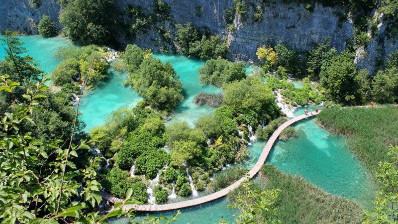
Plitvice Lakes National Park, Kroatien
Entrance 2 is recommended
Opening times - National Park "Plitvička jezera" (np-plitvicka-jezera.hr)
Kroatien
44° 51' 55.4" N 15° 34' 55.2" E
44.8653966 15.5820119
• Head northwest. Go for 6.4 km.
• Continue on Gornji Babin Potok. Go for 343 m.
• Turn right onto Gornji Babin Potok. Go for 238 m.
• Turn right onto Gornji Babin Potok (52). Go for 21.4 km.
• Take the 1st exit from roundabout onto 50 toward Rijeka/Senj/Otočac. Go for 44.9 km.
• Take the 2nd exit from roundabout onto Ulica Filipa Vukasovića (8) toward Rijeka. Go for 22.1 km.
• Continue toward Ulica Zatrep/8. Go for 22 m.
• Take the 2nd exit from roundabout onto Ulica Zatrep (8) toward Rijeka/Otok Krk/Crikvenica. Go for 21.7 km.
• Take ramp toward Otok Lošinj/Otok Cres/Otok Krk. Go for 241 m.
• Take the 3rd exit from roundabout onto 102. Go for 6.1 km.
• Take the 3rd exit from roundabout onto 102 toward Krk/Cres-Lošinj/Njivice. Go for 11.2 km.
• Pass 2 roundabouts and continue on 102. Go for 10.1 km.
• Take the 1st exit from roundabout onto 5131 toward Krk. Go for 328 m.
• Continue on Ulica Stjepana Radića (5131). Go for 1.1 km.
• Turn right onto Ulica Stjepana Radića toward Krk. Go for 89 m.
• Turn left toward Ulica dr. Dinka Vitezića. Go for 77 m.
• Continue on Ulica dr. Dinka Vitezića. Go for 100 m.
• Arrive at Ulica dr. Dinka Vitezića. Your destination is on the left.
☍
146,6 km
(2 hrs. 33 min.)
Krk, Kroatien
45° 1' 40.4" N 14° 34' 30.8" E
45.0278995 14.5752114
• Head south on Ulica dr. Dinka Vitezića. Go for 43 m.
• Turn slightly right onto Ulica Petra Žgaljića. Go for 120 m.
• Turn right onto Trg Krčkih Glagoljaša. Go for 46 m.
• Turn slightly left toward Ulica Stjepana Radića. Go for 40 m.
• Continue on Ulica Stjepana Radića. Go for 100 m.
• Turn left onto Ulica Stjepana Radića (5131) toward Omišalj/Malinska. Go for 1.1 km.
• Continue on 5131. Go for 312 m.
• Take the 2nd exit from roundabout onto 102 toward Rijeka/Malinska. Go for 8.7 km.
• Pass 3 roundabouts and continue on 102. Go for 18.6 km.
• Keep left onto 102 toward Zagreb/Rijeka/Uvala Scott/Kraljevica. Go for 139 m.
• Take the 2nd exit from roundabout onto E65. Go for 674 m.
• Continue on A7. Go for 15.2 km.
• Keep left onto Orehovica (A7) toward Ljubljana/Trieste/Pula/Rijeka zapad. Go for 28.7 km.
• Continue on 202. Go for 256 m.
• Continue on Jelšane (6). Go for 9.9 km.
• Take the 2nd exit from roundabout onto Bazoviška cesta toward Center. Go for 247 m.
• Take the 2nd exit from roundabout onto Bazoviška cesta toward Ljubljana/Postojna. Go for 448 m.
• Take the 1st exit from roundabout onto Gregorčičeva cesta. Go for 624 m.
• Take the 2nd exit from roundabout onto Šercerjeva cesta (404) toward Knežak. Go for 842 m.
• Take the 2nd exit from roundabout onto Šercerjeva cesta (404). Go for 909 m.
• Continue on Topolc (404). Go for 1.5 km.
• Continue on Podstenje (404). Go for 109 m.
• Continue on Topolc (404). Go for 580 m.
• Continue on Šembije (404). Go for 2.8 km.
• Continue on Knežak (404). Go for 3.6 km.
• Continue on Zagorje (404). Go for 2.4 km.
• Continue on Drskovče (404). Go for 897 m.
• Continue on Parje (404). Go for 1.3 km.
• Continue on 404. Go for 798 m.
• Continue on Snežniška cesta (404). Go for 1.2 km.
• Turn right onto Postojnska cesta (6) toward Ljubljana/Postojna. Go for 280 m.
• Take the 3rd exit from roundabout onto Postojnska cesta (6). Go for 8.5 km.
• Take ramp onto A1 toward Ljubljana. Go for 44.3 km.
• Take left exit 36 toward Beljak/Villach/Kranj/Ljubljana-sever onto A2. Go for 51.1 km.
• Take exit 3 toward Lesce/Bohinj/Pokljuka/Bled/Žirovnica/Vrba. Go for 745 m.
• Take the 2nd exit from roundabout onto 209 toward Bohinj/Pokljuka/Bled/Lešče. Go for 1.3 km.
• Pass 2 roundabouts and continue on Alpska cesta (209). Go for 1.7 km.
• Take the 1st exit from roundabout onto Ljubljanska cesta (209). Go for 524 m.
• Take the 2nd exit from roundabout onto Ljubljanska cesta (209) toward Bohinj/Pokljuka. Go for 1.8 km.
• Turn left onto Mlinska cesta toward Selo. Go for 190 m.
• Continue on Mlinska cesta. Go for 624 m.
• Turn slightly left onto Selo pri Bledu. Go for 46 m.
• Turn slightly left onto Selo pri Bledu. Go for 59 m.
• Turn slightly left onto Selo pri Bledu. Go for 65 m.
• Arrive at Selo pri Bledu. Your destination is on the left.
☍
213,3 km
(2 hrs. 47 min.)
Day
Day
Triglav National Park, Selo pri Bledu, Slowenien
4260 Selo pri Bledu, Slowenien
46° 21' 12.3" N 14° 6' 24.3" E
46.3534145 14.1067429
• Head west on Selo pri Bledu. Go for 449 m.
• Continue on Mlinska cesta. Go for 535 m.
• Turn right onto Cesta svobode (209). Go for 1.8 km.
• Take the 2nd exit from roundabout onto Ljubljanska cesta (209). Go for 465 m.
• Take the 1st exit from roundabout onto Ljubljanska cesta (209). Go for 1.4 km.
• Pass 2 roundabouts and continue on Alpska cesta (209). Go for 1.5 km.
• Take the 2nd exit from roundabout onto A2 toward Jesenice. Go for 21.2 km.
• Continue on Karawankentunnel (A11). Go for 21.1 km.
• Continue on A10 (Tauern Autobahn) toward E55/E66/Salzburg/Villach-Ossiacher See. Go for 149 km.
• Take exit 34 toward Paß Lueg. Go for 455 m.
• Take the 1st exit from roundabout onto Pass-Lueg-Straße (B159) toward Pass Lueg. Go for 7.7 km.
• Take the 3rd exit from roundabout onto Salzachtal Bundesstraße (B159). Go for 298 m.
• Turn slightly left toward Salzburg/Villach. Go for 103 m.
• Take ramp onto A10 (Tauern Autobahn) toward Salzburg/München. Go for 27.1 km.
• Take the exit onto A1 (West Autobahn). Go for 3.5 km.
• Continue on A8. Go for 114 km.
• Take exit 95 toward Nürnberg/Stuttgart/Messe/ICM/Flughafen München onto A99. Go for 29.9 km.
• Take exit 13 toward Berlin/Nürnberg/Deggendorf/Flughafen München onto A9. Go for 89.1 km.
• Keep left onto A9. Go for 61.0 km.
• Keep left onto E45 (Autobahnkreuz Nürnberg) toward Frankfurt a.M./Würzburg/Bamberg/Flughafen/A3/Nürnberg-Nord. Go for 2.3 km.
• Continue on A3. Go for 20.2 km.
• Take the exit toward Suhl/Bamberg/Schweinfurt/Erlangen onto A73 (Frankenschnellweg). Go for 52.4 km.
• Take exit 19 toward Breitengüßbach-Mitte/Ebern/Baunach. Go for 274 m.
• Turn left onto B279 toward Fulda/Bad Neustadt a.d. Saale/Ebern/Baunach. Go for 53.0 km.
• Continue on Großeibstädter Straße (B279) toward A71/Fulda/Bad Neustadt/Trappstadt/Hoher Markstein Gewerbegebiet. Go for 13.5 km.
• Turn left and take ramp onto A71 toward Erfurt. Go for 10.4 km.
• Take exit 24 toward Mellrichstadt/Fladungen/Ostheim/Hendungen. Go for 294 m.
• Turn right onto B285 toward Fladungen/Ostheim/Gewerbegebiet Mellrichstadt. Go for 10.8 km.
• Turn right onto Krankenhausstraße. Go for 124 m.
• Continue on Heimegasse. Go for 373 m.
• Arrive at Friedenstraße. Your destination is on the right.
☍
694,8 km
(6 hrs. 48 min.)
Day
Day
Ostheim vor der Rhön, Deutschland
50° 27' 38.9" N 10° 13' 49.8" E
50.4608058 10.2305055