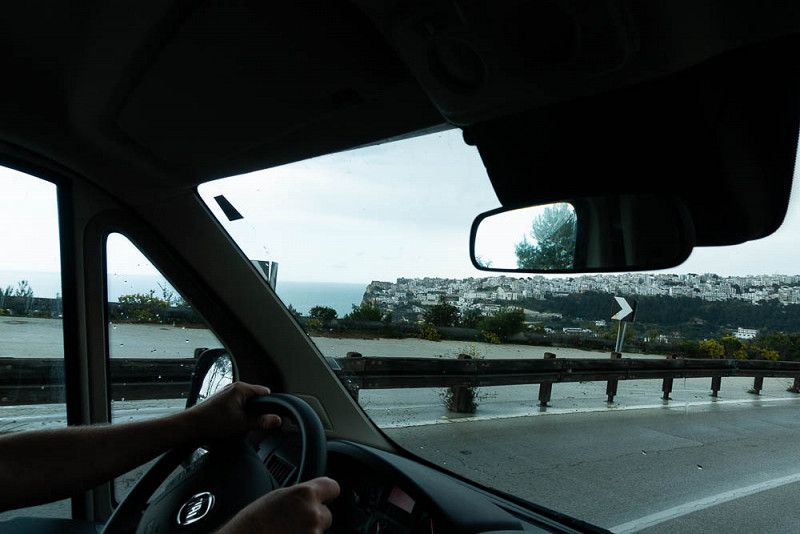
Grandma and Grandpa are gone!
After being away from home for 8 weeks, we set out to discover Italy. Our trip is not planned in detail. We definitely want to reach the southernmost tip of Sicily. The route will be spontaneous depending on your mood, weather and open campsites. We don't think it's necessary to report on campsites because you can find enough information on various platforms (e.g. FREEONTOUR).
Burgenland, Austria
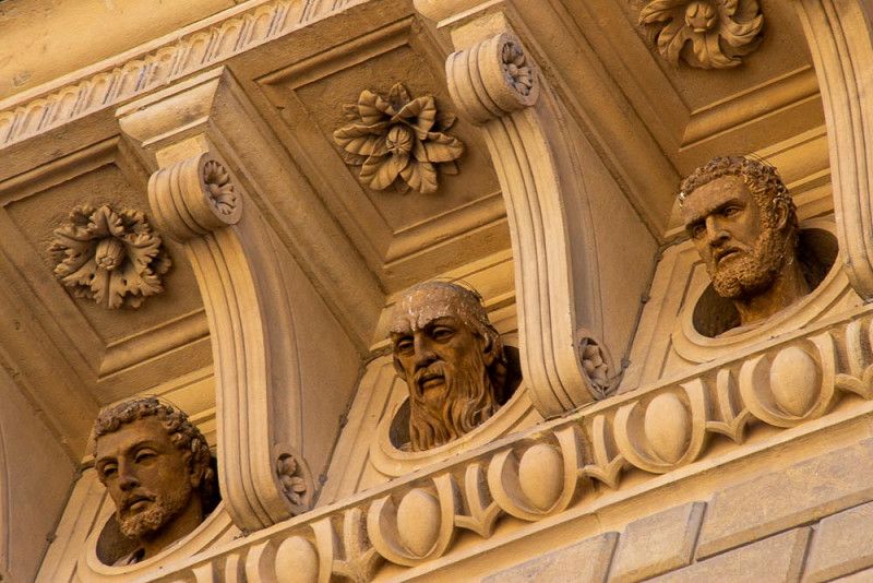
Rathaus Oberwart, 9, Hauptplatz, Oberwart/Felsőőr, Bezirk Oberwart, Burgenland, 7400, Austria
47° 17' 15.9" N 16° 12' 48.7" E
47.2877581 16.2135409
• Head toward Untere Bahnzeile on Rathausgasse. Go for 98 m.
• Turn right onto Untere Bahnzeile. Go for 86 m.
• Turn right onto Schlaininger Straße (L240). Go for 124 m.
• Turn left onto Steinamangerer Straße (B63). Go for 969 m.
• Turn right onto Unterwarter Straße (L269). Go for 335 m.
• Take the 3rd exit from roundabout onto Oberwarter Bundesstraße (B63a) toward Wien/A2/Graz/Gewerbegebiet Oberwart-Nord 1 u. 2/Gewerbegebiet Oberwart-West 1 u. 2/EO Einkaufszentrum. Go for 439 m.
• Take the 2nd exit from roundabout onto Oberwarter Bundesstraße (B63a). Go for 2.7 km.
• Take the 3rd exit from roundabout onto Grazer Straße (B50) toward Wien/A2/Graz/Slowenien/Güssing/Hartberg. Go for 2.6 km.
• Turn right onto Burgenland Bundesstraße (B50) toward Wien/A2/Graz/Hartberg/Markt Allhau. Go for 5.9 km.
• Keep left onto Anschlussstelle Lafnitztal Oberwart. Go for 153 m.
• Take ramp onto A2 (Süd Autobahn) toward Graz. Go for 208 km.
• Take the left exit onto A2 (Süd Autobahn). Go for 53.0 km.
• Continue on A23 (Autostrada Alpe-Adria). Go for 74.7 km.
• Take the exit toward Gemona/Osoppo/Buia/S. Daniele. Go for 561 m.
• Turn left onto SP49 toward S.Daniele. Go for 3.8 km.
• Take the 1st exit from roundabout onto Provinciale Osovana (SP49). Go for 1.5 km.
• Take the 2nd exit from roundabout onto Via Rivoli (SR463). Go for 3.9 km.
• Pass 2 roundabouts and continue on Via Tiveriacco (SR463). Go for 5.4 km.
• Take the 3rd exit from roundabout onto Via Venezia (SR463). Go for 6.1 km.
• Take the 2nd exit from roundabout onto Viale Alcide De Gasperi (SR463). Go for 3.9 km.
• Take the 1st exit from roundabout onto Via Udine (SS464). Go for 800 m.
• Continue on SS464. Go for 63 m.
• Continue on Piazza Plebiscito (SS464). Go for 186 m.
• Continue on SS464. Go for 300 m.
• Take the 1st exit from roundabout onto SS464. Go for 3.1 km.
• Continue toward Via Ponte Roitero/SS464. Go for 107 m.
• Take the 2nd exit from roundabout onto Via Ponte Roitero (SS464). Go for 1.1 km.
• Take the 3rd exit from roundabout onto Via Barbeano (SP73). Go for 684 m.
• Continue on SP73. Go for 805 m.
• Continue toward Rampa A. Go for 57 m.
• Take the 1st exit from roundabout onto Rampa A. Go for 4.4 km.
• Take the 2nd exit from roundabout onto Strada Provinciale di Tauriano (SP23). Go for 3.1 km.
• Take the 2nd exit from roundabout onto Strada Provinciale di Tauriano (SP23). Go for 2.0 km.
• Take the 3rd exit from roundabout onto Strada Provinciale Vivarina (SP27). Go for 603 m.
• Take the 2nd exit from roundabout onto Piazza Umberto I (SP27). Go for 134 m.
• Continue on Via Vittorio Emanuele (SP27). Go for 128 m.
• Turn right onto Via di Porto. Go for 166 m.
• Arrive at Via di Porto. Your destination is on the left.
☍
392,4 km
(4 hrs. 2 min.)
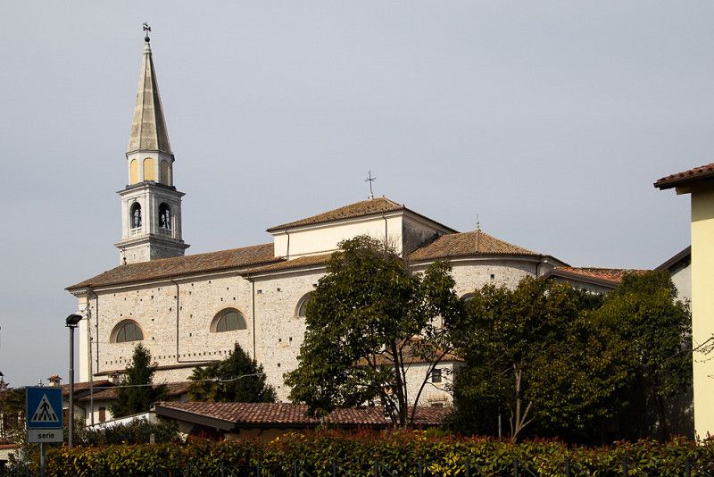
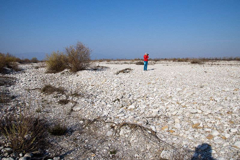
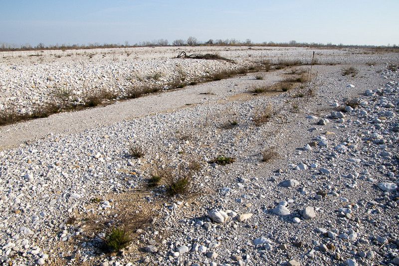
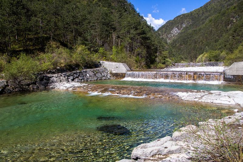
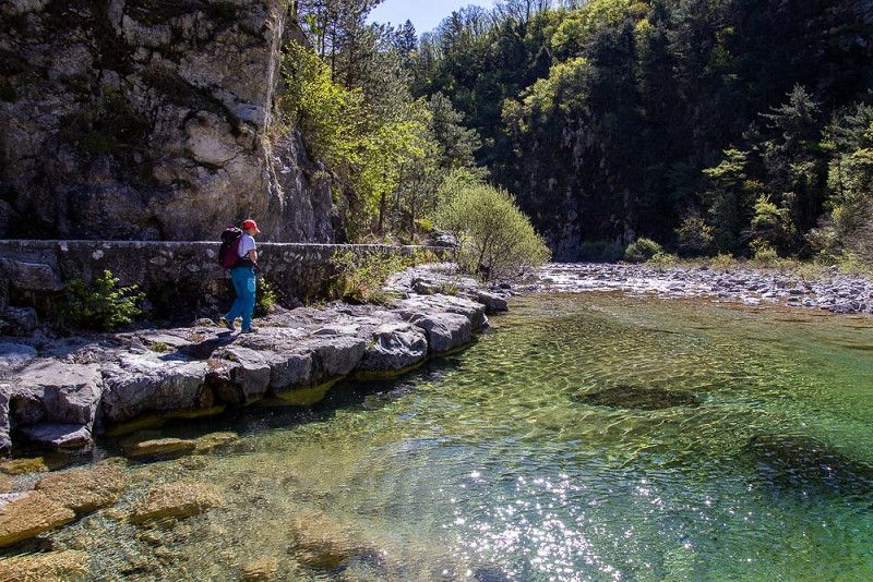
Vivaro im Distrikt Friaul
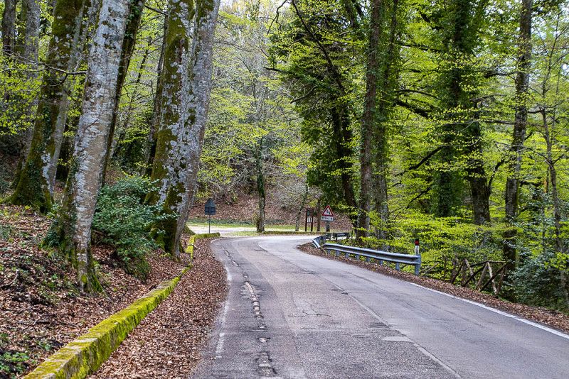
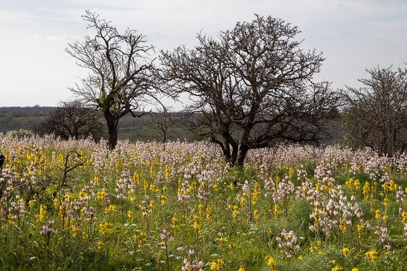
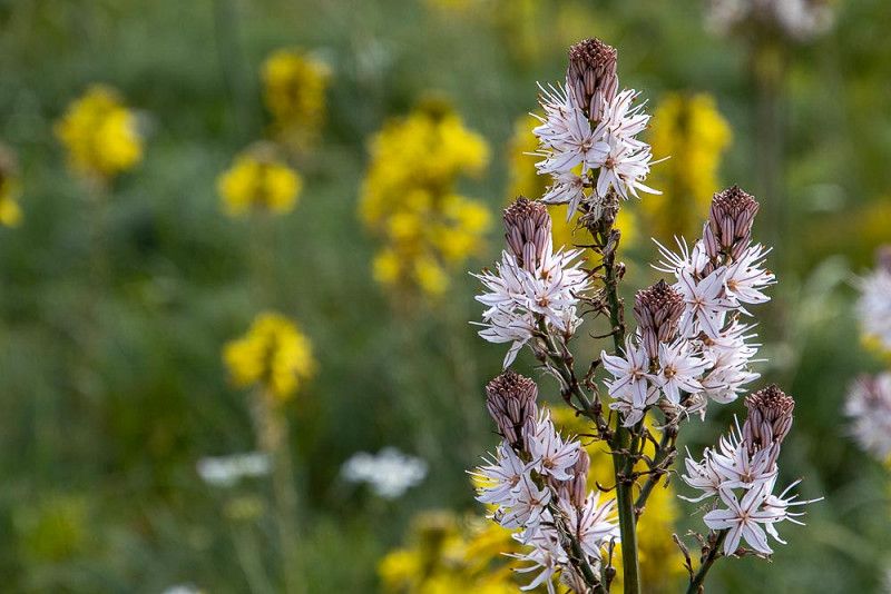
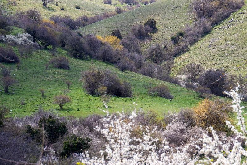
The small town lies on the huge gravel banks of the rivers Tagliamento and Meduna, which have dragged stones from the Friulian Dolomites and ground them for thousands of years.
After a long hike through the gravel banks with their sparse vegetation, we like to be pampered and enjoy a glass of local wine with regional cuisine.
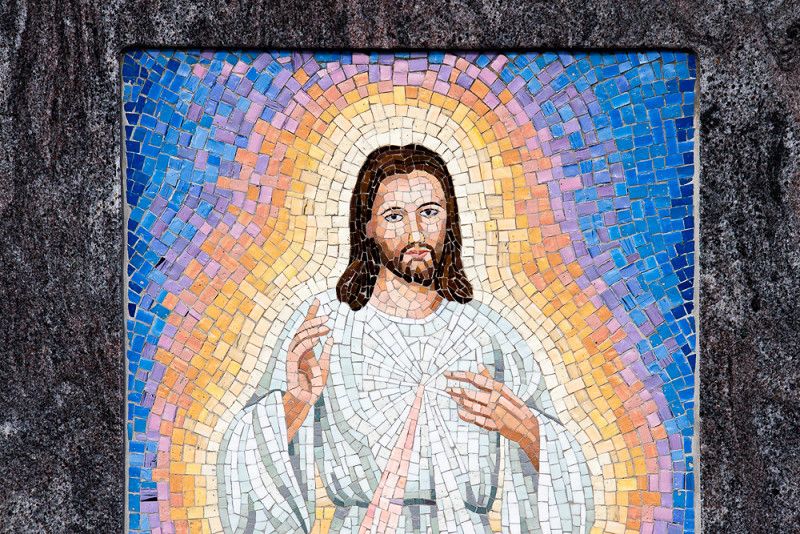
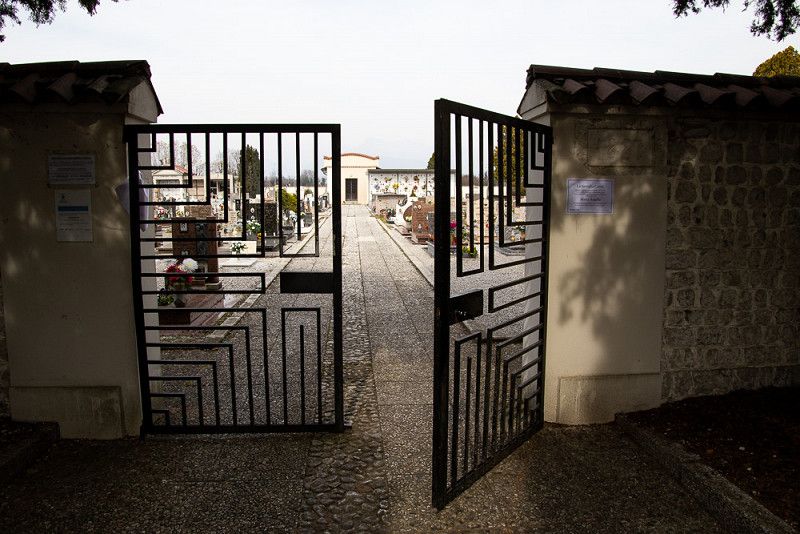
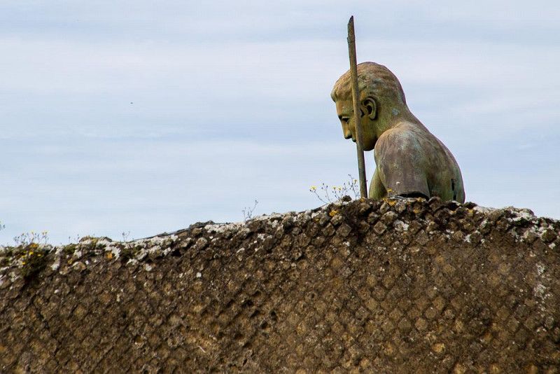
The village of Spilimbergo is nearby and is known for the production of ceramic mosaics. Courses are also offered for those who are interested. We admire some of these works of art, in the form of portraits, in the Vivaro cemetery.
Via di Porto, Basaldella, Vivaro, Pordenone, Friuli-Venezia Giulia, 33099, Italy
46° 4' 32.7" N 12° 46' 26.9" E
46.0757603 12.7741336
• Head toward Via Vittorio Emanuele on Via di Porto. Go for 166 m.
• Turn right onto Via Vittorio Emanuele (SP27). Go for 408 m.
• Take the 1st exit from roundabout onto Via Rauscedo (SP27). Go for 3.5 km.
• Turn left and take ramp. Go for 312 m.
• Continue on SR177. Go for 15.3 km.
• Continue on Autostrada Portogruaro-Pordenone-Conegliano (RA16). Go for 2.9 km.
• Keep left onto Autostrada Portogruaro-Pordenone-Conegliano (RA16) toward A4/Portogruaro/Trieste/Venezia. Go for 443 m.
• Take the 3rd exit from roundabout onto A28 (Autostrada Portogruaro-Pordenone-Conegliano) toward A4/Portogruaro. Go for 16.9 km.
• Take the exit toward Venezia onto A4 (Autostrada della Serenissima). Go for 45.0 km.
• Take the exit toward Venezia Est/Aeroporto onto A57. Go for 10.1 km.
• Take the exit toward Mestre Via Terraglio Centro/Ospedale. Go for 866 m.
• Take the 3rd exit from roundabout onto Via Martiri della Libertà (SR14) toward Mestre Est Centro/Aeroporto/Autostrade/Venezia/SS11/Mestre Centro/Venezia Centro. Go for 5.3 km.
• Keep left onto Via Martiri della Libertà (SR14) toward Campalto/Trieste/SS14/Treviso/SS13/Autostrade/Aeroporto. Go for 89 m.
• Take the 2nd exit from roundabout onto Via Orlanda toward Autostrade/Treviso/Trieste/Aeroporto. Go for 215 m.
• Arrive at Via Orlanda. Your destination is on the right.
☍
101,4 km
(1 hrs. 3 min.)
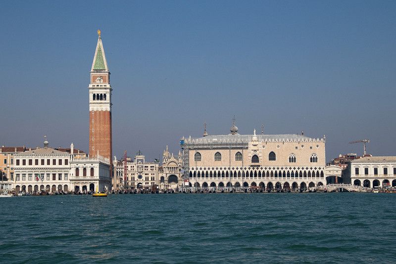
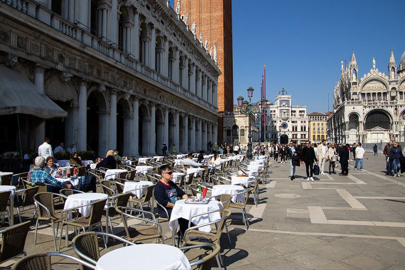
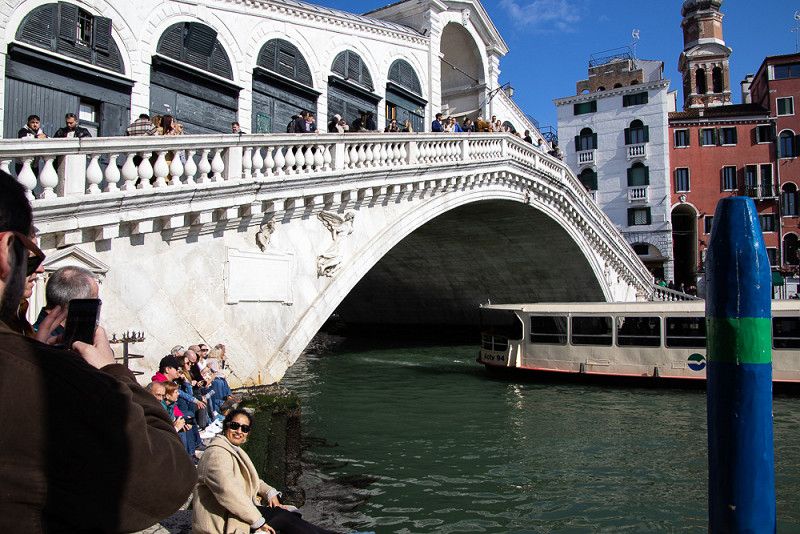
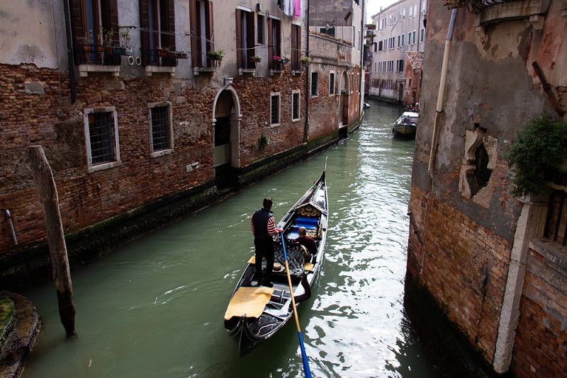
Venedig zwischen Karneval und Hauptsaison
We chose the Venezia Village campsite because it has good public transport connections.
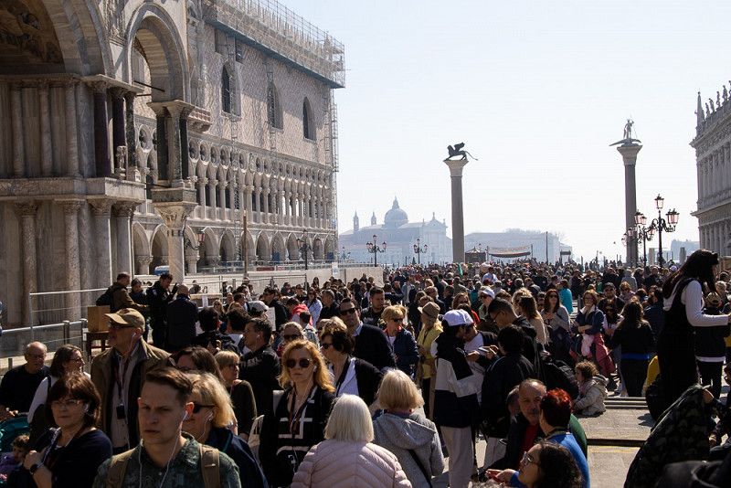
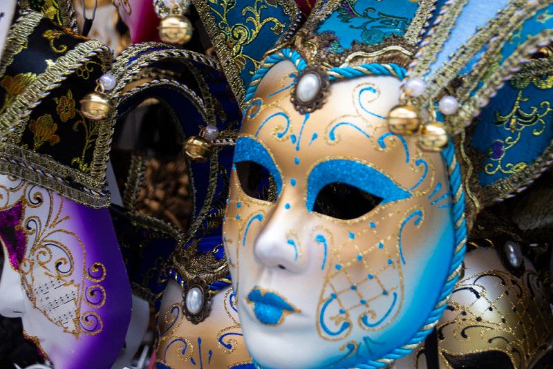
With bus line 5 we are already in the middle of the action after 2 stops, swimming with the flow of tourists and squeezing through the narrow streets of the city, which are flanked by window displays from which the lavishly designed carnival masks smile at us.
We cross countless bridges and occasionally catch a glimpse of a typical Venetian gondola with a smart gondolier. Many of them, it seems, are still becoming fads because the large tourist masses - fortunately for us - have not yet arrived.
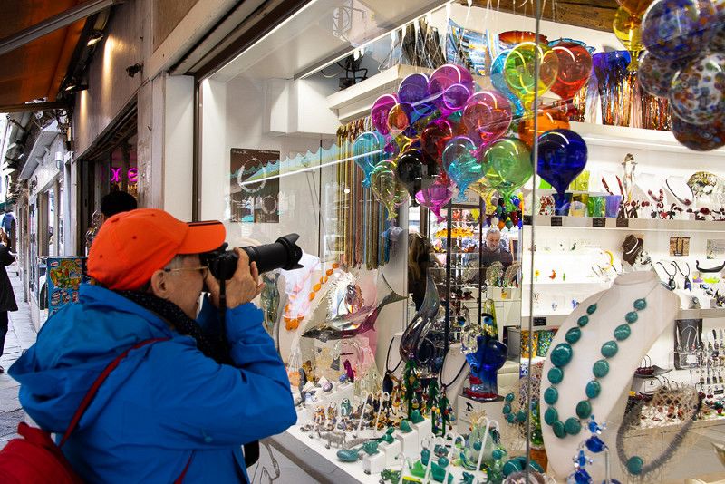
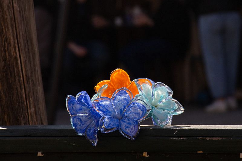
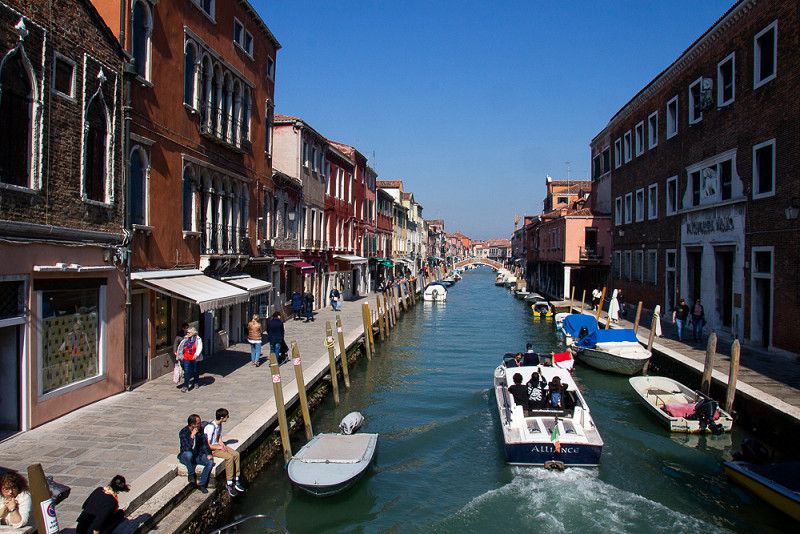
The glassblowing island of Murano is also on our program. It is easy to reach by vaporetto. The works of art made of glass in a wide variety of shapes and colors in the rows of displays invite you to marvel and buy.
Via Orlanda, Tronchetto, Mestre, Venezia, Italy
45° 28' 51.4" N 12° 16' 30" E
45.4809567 12.2749901
• Head northwest on Via Orlanda. Go for 129 m.
• Take the 3rd exit from roundabout onto Via Orlanda (SR14) toward Mestre Centro/Venezia Centro/Padova/Ravenna. Go for 765 m.
• Take the 4th exit from roundabout onto Via San Giuliano (SR14) toward Milano/A4/Bologna/A13/Venezia/SS11/Padova/Ravenna/SS309. Go for 757 m.
• Keep right onto Via San Giuliano (SR14) toward Milano/A4/Bologna/A13/Venezia/Padova/SS11/Ravenna/SS309. Go for 365 m.
• Take ramp onto Via della Libertà (SR11) toward Milano/A4/Bologna/A13/Padova/SS11/Ravenna/SS309. Go for 2.2 km.
• Keep right toward Marghera/A4/A57/Autostrade/Tangenziale. Go for 1.7 km.
• Keep left toward E70/Milano/A4/Bologna/A13/Padova/SR11/Ravenna/SS309. Go for 915 m.
• Take ramp. Go for 434 m.
• Take the 3rd exit from Rotonda Romea roundabout toward Padova/Ravenna. Go for 399 m.
• Continue on Strada Statale Romea (SS309). Go for 1.3 km.
• Continue toward Strada Statale Romea/SS309. Go for 72 m.
• Take the 3rd exit from roundabout onto Strada Statale Romea (SS309) toward Ravenna/Chioggia/Padova/SP81. Go for 1.2 km.
• Take the 3rd exit from roundabout onto Strada Statale Romea (SS309) toward Ravenna. Go for 2.5 km.
• Take the 2nd exit from roundabout onto Strada Statale Romea (SS309) toward Malcontenta. Go for 26.3 km.
• Take the 2nd exit from roundabout toward Ravenna/Chioggia. Go for 237 m.
• Continue on Strada Statale Romea (SS309). Go for 44.6 km.
• Pass 3 roundabouts and continue on Strada Statale Romea (SS309). Go for 31.5 km.
• Arrive at Strada Statale Romea (SS309).
☍
115,4 km
(1 hrs. 39 min.)
Ravenna, Emilia-Romagna, Italy
Via Bellocchio, 44024, Ravenna, Italy
44° 37' 22" N 12° 14' 46.7" E
44.6227830 12.2463088
• Head south on Strada Statale Romea (SS309). Go for 6.4 km.
• Take the 2nd exit from roundabout toward Autostrada/A14/Ravenna. Go for 114 m.
• Continue on Via Romea Nord (SS309). Go for 4.6 km.
• Take the 1st exit from roundabout onto Via Romea Nord (SS309) toward Ravenna/Autostrada/A14. Go for 7.6 km.
• Keep left onto Via San Vitale Strada Statale (SS309dir) toward Bologna-Bari/A14/Ferrara-Rimini/SS16/Bologna/SP253/Forlì/SS67/Tiberina/SS3bis/E45. Go for 2.0 km.
• Take the 2nd exit from roundabout onto Via San Vitale Strada Statale (SS309dir) toward Bologna-Ancona/A14/SS3bis/E45/SS16/Bologna. Go for 3.4 km.
• Continue on A14dir. Go for 528 m.
• Take the exit toward Ravenna Centro/Rimini/Cesena-Roma/E45 onto SS16 (Via Reale). Go for 6.1 km.
• Take the 2nd exit from roundabout onto Via Classicana (SS16) toward E45/Cesena/Roma/Rimini. Go for 1.1 km.
• Take ramp onto Innesto SS16 Adriatica (SS3bis) toward Ancona/A14/Roma. Go for 21.2 km.
• Take ramp onto A14 (Autostrada Adriatica) toward Ancona/Bologna-Ancona. Go for 34.6 km.
• Take the exit toward Rimini Sud/San Marino. Go for 816 m.
• Continue on Via Consolare (SS72). Go for 9.9 km.
• Continue on Via Tre Settembre. Go for 1.2 km.
• Continue on Via Quattro Giugno. Go for 822 m.
• Take the 3rd exit from roundabout onto Via Quattro Giugno. Go for 797 m.
• Continue on Via Cinque Febbraio. Go for 241 m.
• Turn right onto Via Ranco. Go for 101 m.
• Keep right onto Via Ranco. Go for 807 m.
• Continue on Strada Nona Gualdaria. Go for 478 m.
• Turn right onto Strada Auloceto. Go for 215 m.
• Turn right onto Strada di San Michele. Go for 231 m.
• Turn right onto Strada di San Michele. Go for 54 m.
• Arrive at Strada di San Michele.
☍
103,3 km
(1 hrs. 12 min.)
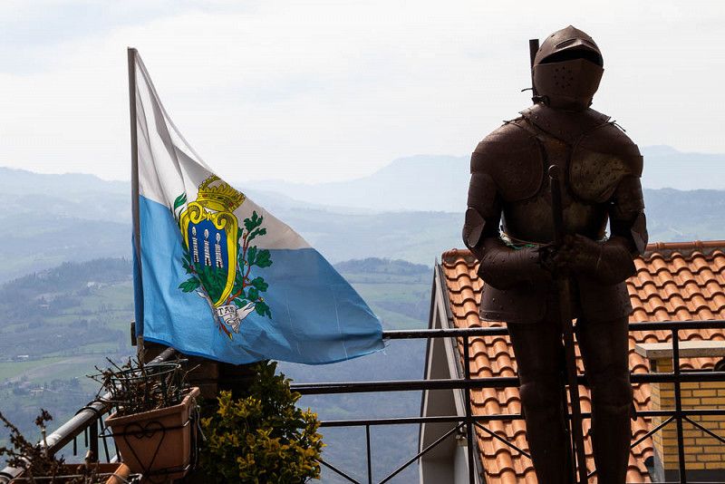
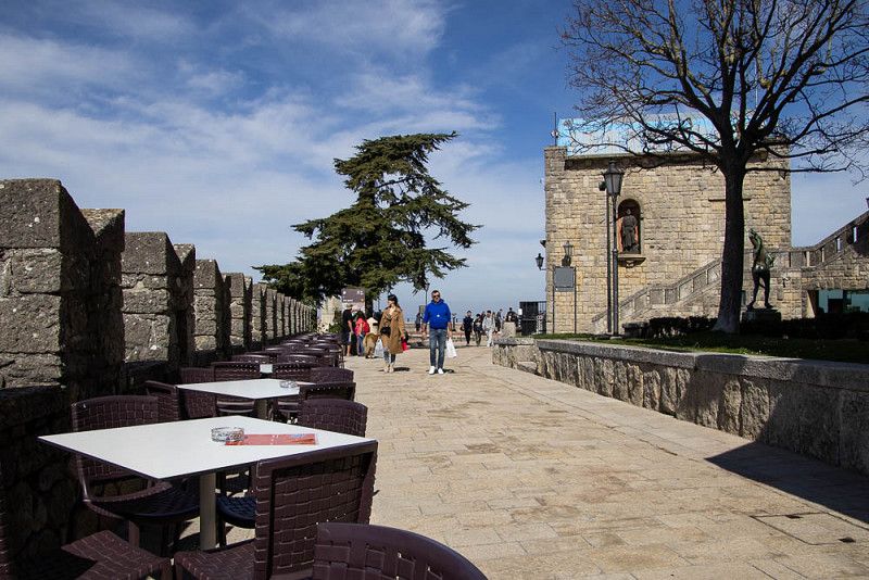
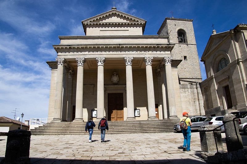
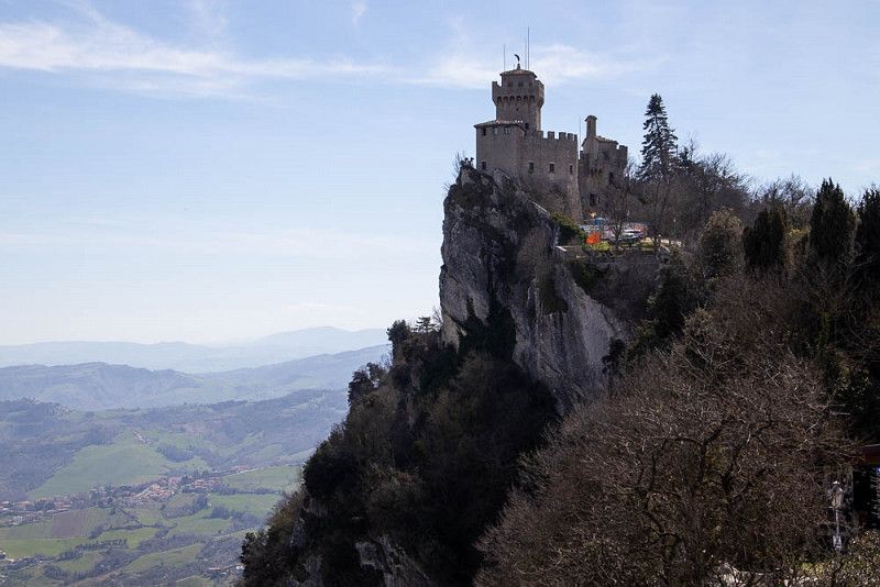
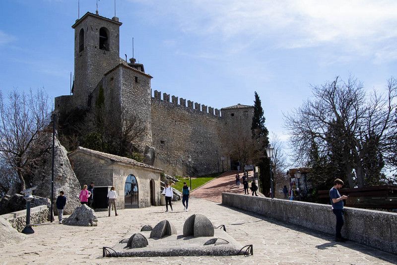
San Marino
As experienced bus drivers, we take line 7 today, which stops in front of our campsite, and save ourselves the steep climb to the center of the old town.
With full power we storm the monumental fortress of San Marino and conquer one defense tower after the other while strolling along. Delighted by the amount of sidewalk cafes and restaurants, it doesn't take long before we settle down for a little break. A small espresso gives us enough fuel for the further ascent.
Countless displays of exclusive leather goods, suits of armor and toys for the kids require total attention.
It's time for a moment's silence in the basilica. After this short relaxation, there are still enough photo motifs of the historical buildings and monuments or the landscape that lies at our feet.
50, Strada Auloceto, Borgo Maggiore, San Marino, 47893
43° 57' 34.5" N 12° 27' 40.5" E
43.9595843 12.4612427
• Head southeast on Strada di San Michele. Go for 127 m.
• Turn left onto Strada di San Michele. Go for 124 m.
• Turn left onto Strada Auloceto. Go for 215 m.
• Turn left onto Strada Nona Gualdaria. Go for 478 m.
• Continue on Via Ranco. Go for 837 m.
• Keep right toward Via Cinque Febbraio. Go for 266 m.
• Continue on Via Cinque Febbraio. Go for 490 m.
• Continue on Via Quattro Giugno. Go for 754 m.
• Take the 1st exit from roundabout onto Via Quattro Giugno. Go for 860 m.
• Continue on Via Tre Settembre. Go for 1.2 km.
• Continue on Strada Statale Consolare Rimini San Marino (SS72). Go for 9.7 km.
• Take ramp onto A14 (Autostrada Adriatica) toward Ancona. Go for 144 km.
• Take the exit toward P.To Sant'Elpidio. Go for 546 m.
• Take the 2nd exit from roundabout toward SS16/Porto S. Giorgio/Fermo. Go for 1.5 km.
• Take the 2nd exit from roundabout onto Strada Statale Adriatica (SS16) toward Ancona/Civitanova Marche. Go for 184 m.
• Turn right onto Via Giuseppe Mazzini toward Lido di Fermo/Porto S.Giorgio. Go for 41 m.
• Turn right onto Via Firenze. Go for 95 m.
• Turn left onto Via Pavia. Go for 35 m.
• Turn right onto Via Pavia. Go for 181 m.
• Take the 3rd exit from roundabout onto Via Milano. Go for 291 m.
• Take the 1st exit from roundabout onto Via Faleria. Go for 126 m.
• Arrive at Via Faleria.
☍
161,7 km
(1 hrs. 28 min.)
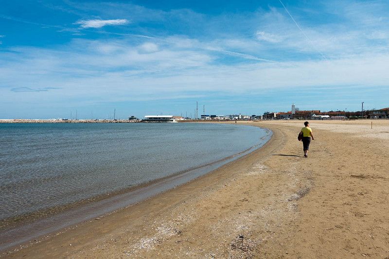
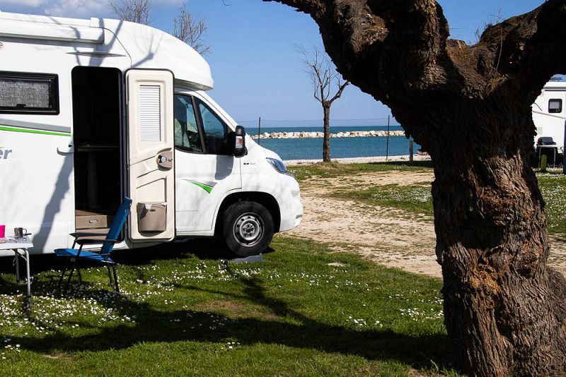
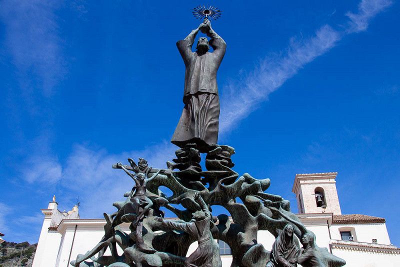
Porto Sant´Elpidio
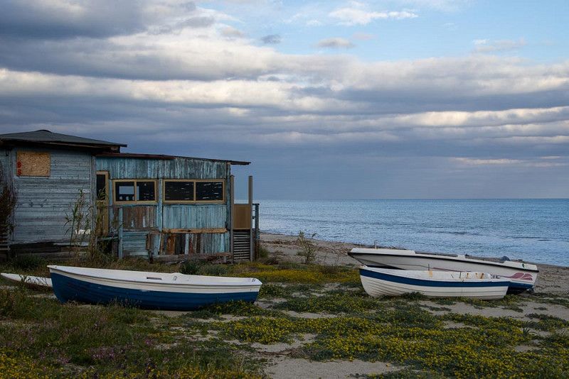
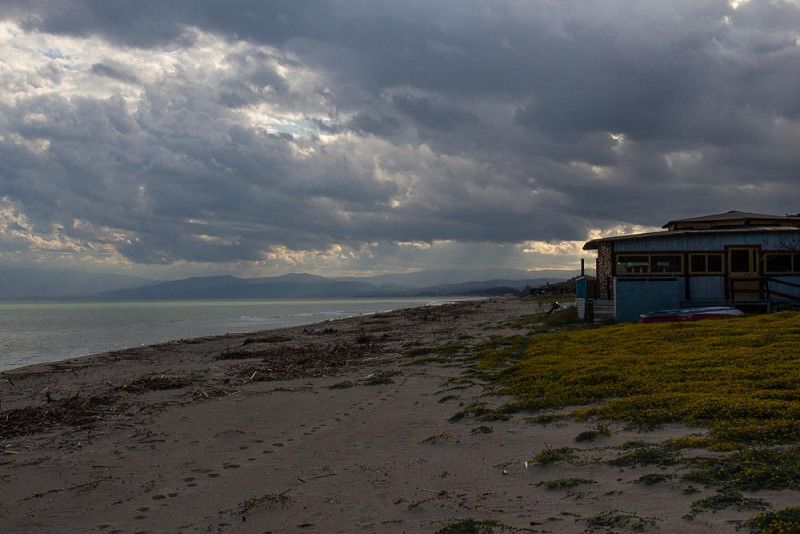
Our pitch at Mimosacamping is, how could it be nicer, just a few steps from the coast.
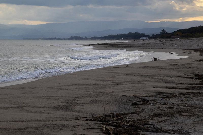
A kilometer-long beach right outside the front door lures us to take a walk along a promenade that is still asleep.
Many takeaways are first prepared for the guests.
We're lucky enough to snag a table at an exclusive restaurant that's already open and treat ourselves to a deliciously prepared menu of fried fish, vegetables and chips, along with a glass of wine. "Salute!"
150, Via Faleria, San Tommaso Tre Archi, Fermo, Italy, 63821
43° 14' 16.6" N 13° 46' 23.1" E
43.2379498 13.7730789
• Head northeast on Via Faleria. Go for 159 m.
• Make a U-Turn at Via Ferrara onto Via Faleria. Go for 259 m.
• Take the 2nd exit from roundabout onto Via Milano. Go for 177 m.
• Turn right onto Via Milano. Go for 63 m.
• Turn right onto Via Piacenza. Go for 243 m.
• Turn left onto Via Voghera. Go for 95 m.
• Turn left onto Via Giuseppe Mazzini (SS16). Go for 238 m.
• Take the 1st exit from roundabout toward Fermo/Porto S. Giorgio/Pescara/Sant 'Elpidio a Mare/Montegiorgio/Amandola/Autostrada/A14/Monte Urano/SP28. Go for 1.4 km.
• Take the 1st exit from roundabout onto A14 (Autostrada Adriatica) toward Autostrada/Pescara. Go for 237 km.
• Take the exit toward Poggio Imperiale/Lesina. Go for 897 m.
• Take the 2nd exit from roundabout onto Strada Scorrimento Veloce del Gargano toward Poggio I.-Rodi G./Peschici-Vieste. Go for 21.2 km.
• Take ramp onto Strada Provinciale Sannicandro Torre Mileto (SP41) toward Sannicandro. Go for 28.1 km.
• Continue on SP41. Go for 26 m.
• Continue on Strada Provinciale Sannicandro Torre Mileto (SP41). Go for 999 m.
• Turn left onto SS89. Go for 992 m.
• Continue on Strada Provinciale San Severo Rodi (SS89). Go for 2.6 km.
• Continue on Corso Madonna della Libera (SS89). Go for 637 m.
• Turn right onto Vico 5 Madonna della Libera. Go for 29 m.
• Turn left onto Corso Ruggero Bonghi. Go for 192 m.
• Turn right onto Via Carmine Grossi (SS89). Go for 83 m.
• Turn left onto Via 20 Settembre (SS89). Go for 387 m.
• Turn right onto Via Trieste (SS89). Go for 291 m.
• Continue on Via Pineta Marzini (SS89). Go for 1.7 km.
• Continue on SS89. Go for 2.3 km.
• Continue on Via Lungomare Andrea Pazienza (SS89). Go for 1.1 km.
• Continue on Via Pineta Marzini (SS89). Go for 1.2 km.
• Continue on SS89. Go for 6.8 km.
• Turn left onto SS89. Go for 2.6 km.
• Take the 1st exit from roundabout onto SS89 toward Vieste/Mattinata/Manfredonia. Go for 10.5 km.
• Continue on Cascina Mandrione (SS89). Go for 266 m.
• Continue toward SS89. Go for 44 m.
• Turn slightly left onto Strada Provinciale del Mandrione (SP52bis). Go for 2.9 km.
• Turn right onto Litoranea Vieste-Peschici (SP52). Go for 3.8 km.
• Turn right onto Contrada Defensola. Go for 249 m.
• Continue toward Località Defensola. Go for 143 m.
• Continue on Località Defensola. Go for 262 m.
• Turn left onto Via Carabella. Go for 746 m.
• Arrive at Via Carabella. Your destination is on the right.
☍
330,9 km
(3 hrs. 29 min.)
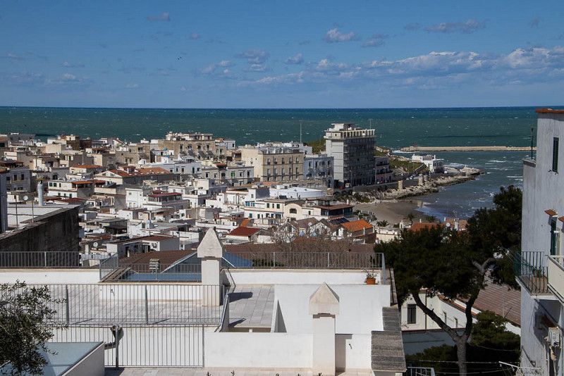
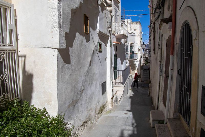
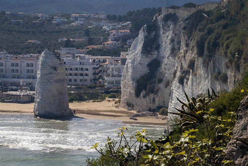
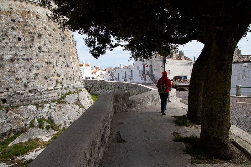
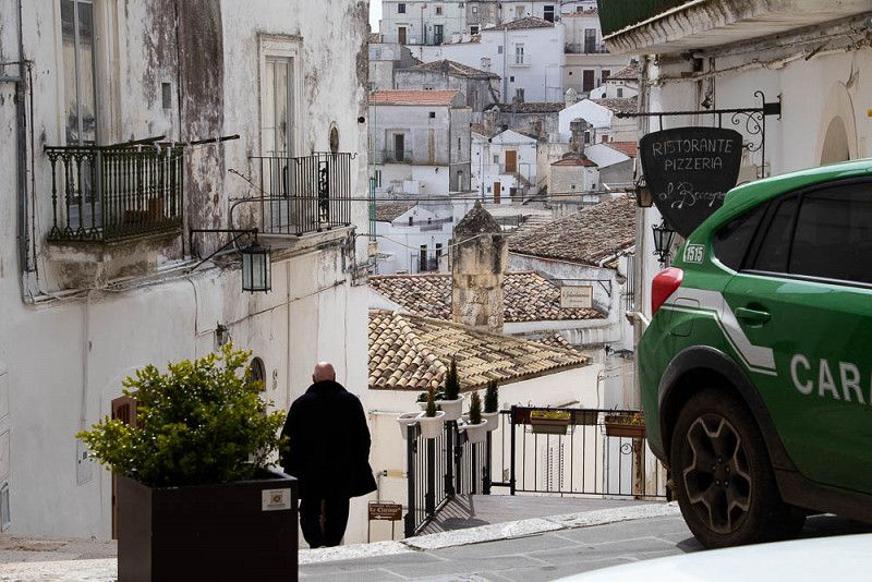
Vieste
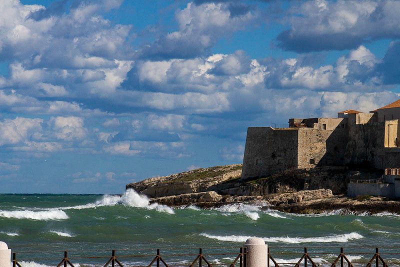
The beach of the former fishing village, which has developed into a tourist attraction, is now being pounded by powerful waves whipped up by the storm as we arrive.
We are therefore looking for a quieter area that is not so exposed to the wind in the winding, narrow streets of the medieval old town. Nearby prehistoric finds show that people have been active in this region since the Bronze Age.
Steep uphill stairs lead us to the Castello and from there we have a wonderful view of the Faraglione Pizzomunno , which was created by the eternally gnawing forces of the water, and now towers up like a church tower on the sandy beach and has to defy the surf lonely.
Strada Vincinale di Carabella, 71019, Italy
41° 53' 27.1" N 16° 9' 8.2" E
41.8908558 16.1522898
• Head southeast on Via Carabella. Go for 956 m.
• Turn right onto Lungomare Europa (SP52). Go for 737 m.
• Take the 1st exit from roundabout onto Via dell'Antico Porto Aviane toward Mattinata/Manfredonia/Foggia/Pugnochiuso. Go for 201 m.
• Take the 3rd exit from roundabout onto Via Giacomo Puccini toward Mattinata/Manfredonia/Foggia/Ospedale. Go for 309 m.
• Turn right onto Via Giuseppe Verdi. Go for 551 m.
• Turn right onto Via Dante Alighieri. Go for 252 m.
• Continue on Località Pietà. Go for 20 m.
• Turn slightly left onto SS89 toward Pugnochiuso/Mattinata. Go for 667 m.
• Continue on Cascina Macchia di Mauro (SS89). Go for 1.2 km.
• Continue on SS89. Go for 30.0 km.
• Turn left toward Strada Provinciale Mattinata Vieste/SP53. Go for 2.1 km.
• Turn right onto Strada Provinciale Mattinata Vieste (SP53). Go for 4.1 km.
• Keep left toward SP53. Go for 44 m.
• Turn left onto SP53. Go for 1.8 km.
• Continue on SS89. Go for 7.6 km.
• Take the 2nd exit from roundabout onto SS89 toward Autostrada/San Giovanni R.Do. Go for 4.5 km.
• Take the 2nd exit from roundabout onto SS89 toward Autostrada/Foggia/S. Giovanni R.Do/Manfredonia. Go for 9.3 km.
• Take ramp onto SS89 toward Manfredonia Sud. Go for 1.7 km.
• Turn right onto SP141. Go for 5.3 km.
• Turn left. Go for 412 m.
• Arrive at your destination on the left.
☍
71,7 km
(1 hrs. 14 min.)
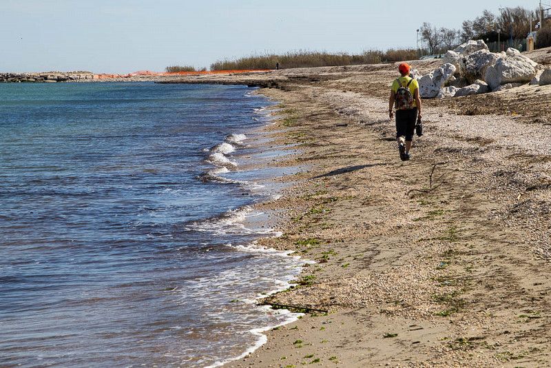
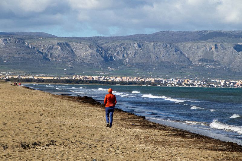
Lesina - Manfredonia
A stormy night is followed by rain. It does not matter. We don't intend to stay here any longer anyway. We were able to capture the ambience of the small town of Lesina , which we reached after a quick drive, on an evening walk.
Considering that we only found the next open campsite 80 kilometers further in Manfredonia , we decide to drive there today and do day trips from there.
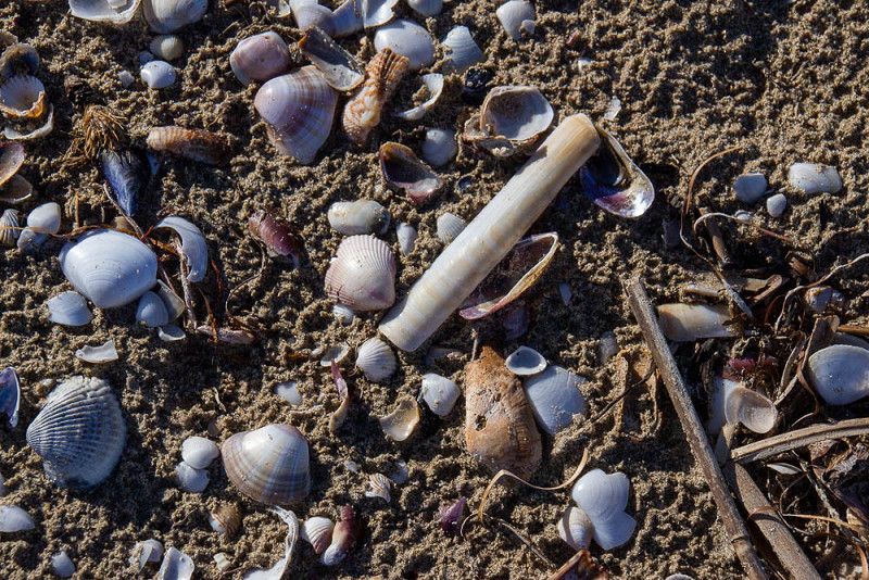
The Gargano peninsula has so much more to offer than the endlessly long sandy beaches, which have always enchanted us with their charm. We have diligently collected lots of shells for our grandchildren at home and have already stowed away safely.
The weather means well, because the rain stopped again in the afternoon and nothing stands in the way of our urge to explore.
SP5 delle Saline, Italy
41° 33' 19.3" N 15° 53' 34.5" E
41.5553525 15.8929253
• Head west. Go for 412 m.
• Turn right onto SP141. Go for 5.3 km.
• Turn left toward Viale Giuseppe Di Vittorio. Go for 61 m.
• Continue on SS89. Go for 887 m.
• Take ramp onto SS89 toward Mattinata/Vieste/San Giovanni R./Monte San'Angelo. Go for 9.8 km.
• Take the 2nd exit from roundabout onto SS89 toward Vieste/Mattinata/Monte S.Angelo. Go for 4.5 km.
• Take the 3rd exit from roundabout onto SS89 toward Monte S.Angelo. Go for 496 m.
• Take ramp onto Via Crocifisso (SP55) toward Monte S.Angelo. Go for 8.2 km.
• Continue on Via Don Luigi Sturzo (SP55). Go for 1.3 km.
• Take the 2nd exit from roundabout onto Via Manfredonia. Go for 167 m.
• Turn left onto Via D. Manfredi. Go for 68 m.
• Turn left onto Via Giovanni Bovio. Go for 67 m.
• Arrive at Via Giovanni Bovio. Your destination is on the right.
☍
31,2 km
( 28 min.)
Monte Sant'Angelo
Today we start a sightseeing tour with our WOMO. After a short drive up a thoroughfare lined with olive tree crops, the route leads steeply uphill, bend by bend, to S.Giovanni , one of the many pilgrimage sites on the mountain. Today, after his canonization by Pope John II, Padre Pio watches over his flock as a statue in many places.
Then, like the pilgrims, we move on to Monte Sant'Angelo , but not on foot. Here too the houses cling to the slope, as before in S.Giovanni .
Plagued by hunger because there are hardly any open restaurants to be found, we accidentally stumble into a small restaurant. As the only guests, we have the comfort of individual service and enjoy excellent regional cuisine.
Now all we need is an afternoon coffee. We treat ourselves to it at a rest area in the middle of the Forest Umbro National Park after we have admired this primeval forest with its huge trees, which are currently in a soft green spring frenzy.
Monte Sant'Angelo, 71037, Italien
41° 42' 19.6" N 15° 58' 3.6" E
41.7054400 15.9676570
• Head west on Via Giovanni Bovio.
• Turn right toward Via D. Manfredi. Go for 28 m.
• Turn right onto Via D. Manfredi. Go for 112 m.
• Turn right onto Via Manfredonia. Go for 150 m.
• Take the 2nd exit from roundabout onto Via Don Luigi Sturzo (SP55). Go for 1.3 km.
• Continue on Via Crocifisso (SP55). Go for 7.9 km.
• Take ramp onto SS89 toward Manfredonia/Foggia/Autostrada. Go for 4.1 km.
• Take the 2nd exit from roundabout onto SS89 toward Autostrada/Foggia/S. Giovanni R.Do/Manfredonia. Go for 9.3 km.
• Take ramp onto SS89 toward Manfredonia Sud. Go for 1.7 km.
• Turn right onto SP141. Go for 8.3 km.
• Take the 2nd exit from roundabout onto SP141. Go for 5.0 km.
• Turn right onto Strada Statale Rivolese (SS545) toward Autostrade/Cerignola/Foggia. Go for 12.2 km.
• Pass 2 roundabouts and continue on Strada Statale Rivolese (SS545). Go for 7.0 km.
• Take ramp onto A14 (Autostrada Adriatica) toward Bari. Go for 21.6 km.
• Take the exit toward Canosa onto SS93. Go for 827 m.
• Take ramp toward Minervino/SR6/Spinazzola. Go for 792 m.
• Continue on SR6. Go for 5.1 km.
• Take ramp onto SS98 (SP231). Go for 3.5 km.
• Take the 1st exit from roundabout onto SP149. Go for 1.7 km.
• Continue on Viale dei Condottieri (SP149). Go for 421 m.
• Continue on SP149. Go for 2.5 km.
• Continue on Contrada Iazzo Nuovo (SP149). Go for 3.2 km.
• Continue on Contrada Lama di Corvo (SP149). Go for 1.3 km.
• Continue on SP149. Go for 8.2 km.
• Continue on Contrada Piano di Citulo (SP149). Go for 1.6 km.
• Turn left onto SP234. Go for 4.2 km.
• Turn left onto SS170dir A. Go for 1.0 km.
• Turn left onto Via Castel del Monte (SP234a). Go for 922 m.
• Arrive at Via Castel del Monte (SP234a). Your destination is on the left.
☍
113,8 km
(1 hrs. 21 min.)
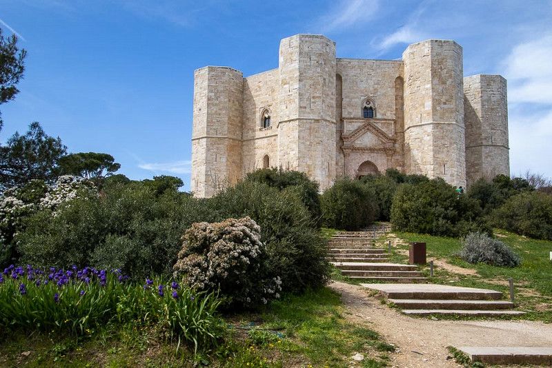
Castel del Monte, Italien
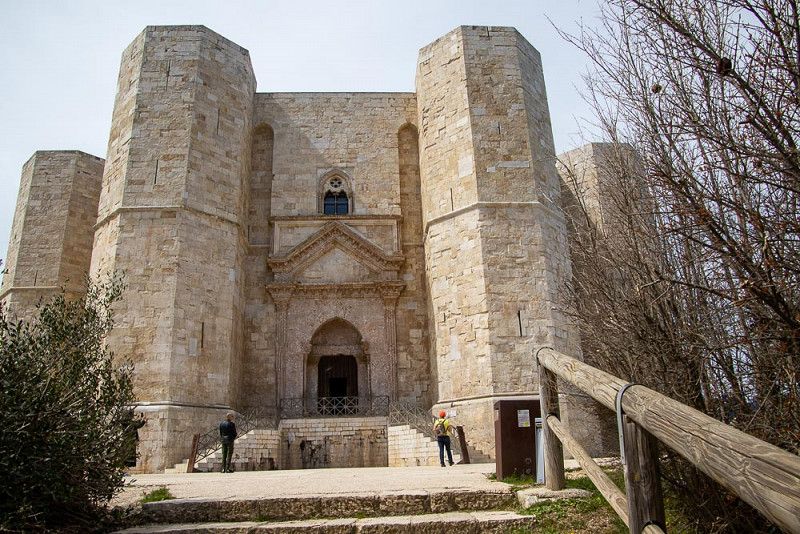
The Castel del Monte , a medieval castle built by the Hohenstaufen Emperor Frederick II , towers majestically on its rock in the Apulia region above the Andria plain . The octagonal, towering structure with its towers at every corner appears very stable and firmly attached to the ground. This architectural work of art is now a World Heritage Site after being renovated in the 1970's and is a magnet for a multitude of tourists.
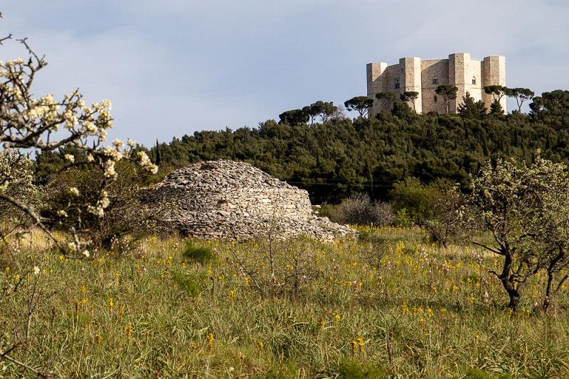
To our surprise, not far away we find a nature park with countless flowering plants, which shine towards us in the backlight of the sun. During a short hike through this area we discover the first trulli , typical round buildings in Apulia made of layered stones. Again and again the Castel in the background crowds into the picture. I can well imagine that from the windows of his castle the emperor had his subjects in his sights.
Strada Provinciale di Castel del Monte, Andria, Italien
41° 5' 5.1" N 16° 16' 15.4" E
41.0847439 16.2709412
• Head west on Via Castel del Monte (SP234a). Go for 922 m.
• Turn right onto SS170dir A. Go for 1.0 km.
• Turn left onto SP234. Go for 9.3 km.
• Pass 2 roundabouts and continue on Strada Provinciale di Castel del Monte (SP234). Go for 6.7 km.
• Keep right onto Strada Provinciale di Castel del Monte (SP234) toward Ruvo di P. Centro/Bari. Go for 920 m.
• Continue on Strada Provinciale Andriese-Coratina (SP231). Go for 30.7 km.
• Keep right toward Strada Bari-Modugno-Toritto. Go for 94 m.
• Continue on Strada Bari-Modugno-Toritto. Go for 239 m.
• Take ramp onto Tangenziale di Bari (SS16) toward Brindisi. Go for 6.6 km.
• Take ramp onto SS100 toward Taranto/Stazione di Mungivacca. Go for 16.8 km.
• Take ramp onto Svincolo Casamassima-SS173 toward Casamassima/Turi/SS172/Putignano. Go for 200 m.
• Turn right onto Strada Statale dei Trulli (SS172) toward Turi/Putignano. Go for 6.2 km.
• Continue on Strada Provinciale Circonvallazione di Turi (SP215). Go for 4.4 km.
• Take the 1st exit from roundabout onto Strada Provinciale Turi Putignano (SS172) toward Putignano/Alberobello/Locorotondo. Go for 6.5 km.
• Take the 2nd exit from roundabout onto SS172 toward Putignano. Go for 3.0 km.
• Turn left onto Viale della Repubblica. Go for 520 m.
• Continue on Viale Tenente Pietro Sbiroli. Go for 144 m.
• Continue on Viale della Libertà. Go for 142 m.
• Continue on Viale Cavalieri di Malta. Go for 325 m.
• Continue on Viale Federico II. Go for 358 m.
• Take the 1st exit from roundabout onto Via Giambattista Carafa Bali. Go for 163 m.
• Continue on Via Martiri delle Foibe. Go for 240 m.
• Take the 3rd exit from roundabout onto Strada Statale dei Trulli (SS172) toward Alberobello. Go for 1.6 km.
• Pass 2 roundabouts and continue on SS172. Go for 10.1 km.
• Continue toward Viale Luigi Einaudi/SS172. Go for 35 m.
• Take the 3rd exit from roundabout onto Viale Luigi Einaudi (SS172) toward Locorotondo/Martina Franca/Taranto. Go for 304 m.
• Continue on Viale Luigi Einaudi (SS172). Go for 38 m.
• Take the 1st exit from roundabout onto Viale Luigi Einaudi (SS172). Go for 735 m.
• Turn right onto Via Antonio Segni (SS604). Go for 232 m.
• Take the 2nd exit from roundabout onto Via 7 Liberatori della Selva (SS604) toward Noci. Go for 898 m.
• Take the 3rd exit from roundabout onto Contrada Bosco Selva toward Taranto/Bari/Fasano. Go for 431 m.
• Continue on Via Bosco Selva. Go for 133 m.
• Continue on Contrada Bosco Selva. Go for 193 m.
• Turn slightly left onto Via Bosco Selva. Go for 246 m.
• Continue on Via Bosco Selva. Go for 520 m.
• Turn right onto Contrada Bosco Selva. Go for 43 m.
• Turn left. Go for 347 m.
• Arrive at your destination on the right.
☍
111,3 km
(1 hrs. 34 min.)
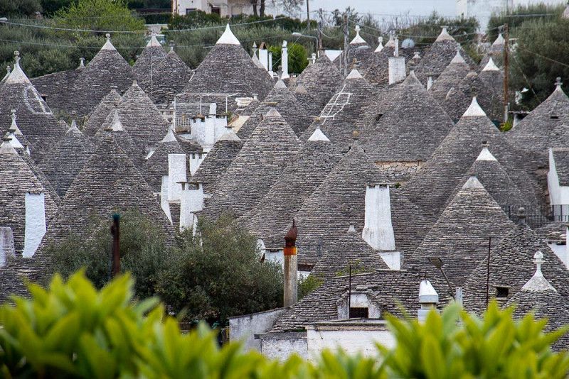
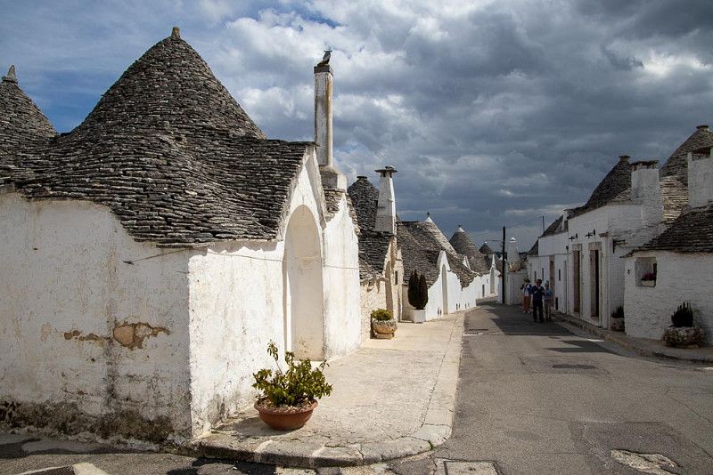
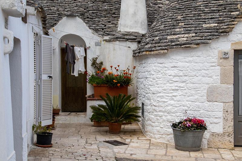
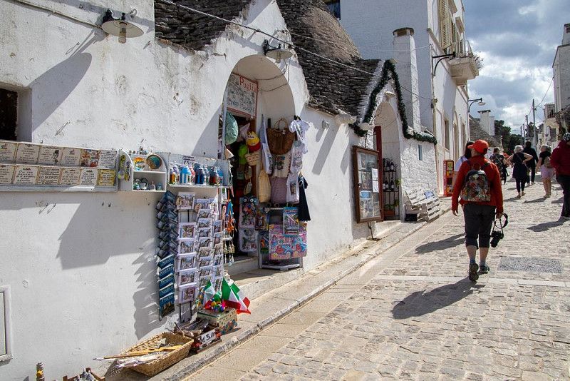
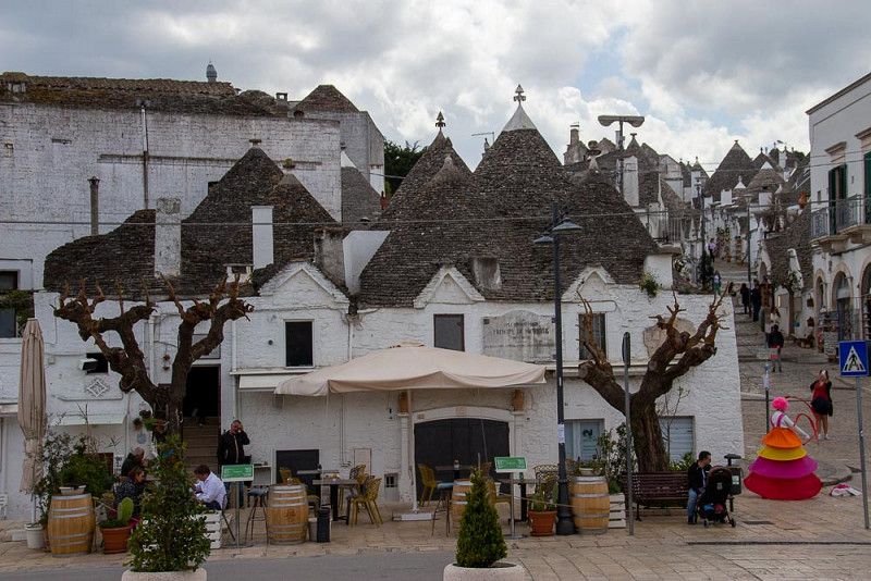
Alberobello
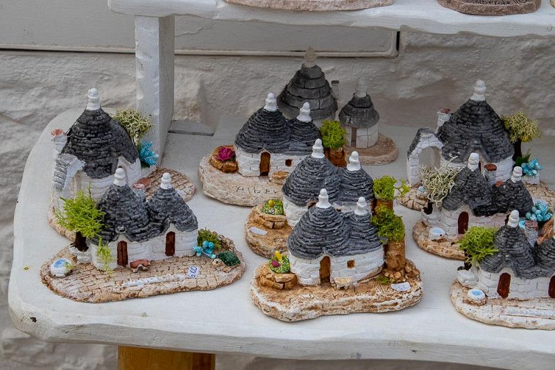
Alberobello is known for its village of countless round trulli from bygone times that have been lovingly restored. The round houses are built of stacked flagstones, which taper towards the top and converge to a point. A stone with a symbolic character often forms the end of the roof, or the roof shingles are painted with it. According to an ambitious shop salesman, these magical symbols can still be found in many religions or signs of the zodiac today.
Today the village is busy with restaurants, souvenir shops and of course with tourists.
Leaving this commercial area, one arrives in a quiet neighborhood where the houses are still inhabited or used as holiday homes.
Again and again we come across the contrasts between the old and the modern way of life.
Today is not only laundry day in Trullihausen. Housework is also waiting for me in WOMO 66. After the work is done, the day ends with a coffee break.
70011, Italy
40° 45' 47.3" N 17° 13' 52.3" E
40.7631305 17.2311890
• Head toward Contrada Bosco Selva. Go for 347 m.
• Turn right onto Contrada Bosco Selva. Go for 43 m.
• Turn left onto Via Bosco Selva. Go for 766 m.
• Turn slightly right onto Contrada Bosco Selva. Go for 193 m.
• Continue on Via Bosco Selva. Go for 133 m.
• Continue on Contrada Bosco Selva. Go for 387 m.
• Take the 3rd exit from roundabout onto Via 7 Liberatori della Selva (SS604) toward Noci. Go for 851 m.
• Take the 2nd exit from roundabout onto Via 7 Liberatori della Selva (SS604). Go for 330 m.
• Turn sharp left onto Via Noci toward Noci. Go for 57 m.
• Continue on Strada Provinciale di Alberobello (SP239). Go for 10.4 km.
• Continue on Strada Provinciale delle Grotte (SP237). Go for 133 m.
• Take ramp onto Via per Mottola toward Mottola/SP237. Go for 399 m.
• Continue on Strada Provinciale delle Grotte (SP237). Go for 1.2 km.
• Take the 3rd exit from roundabout onto Strada Provinciale delle Grotte (SP237). Go for 6.7 km.
• Continue on SS377. Go for 10.2 km.
• Take ramp onto SS100 toward Taranto. Go for 6.0 km.
• Take ramp onto Via Appia (SS7) toward Palagiano/Matera/Reggio C./SS106. Go for 2.3 km.
• Continue on Strada Statale Jonica (SS106dir). Go for 6.5 km.
• Take ramp toward Reggio C./SS106. Go for 169 m.
• Take the 3rd exit from roundabout toward Reggio C. Go for 88 m.
• Take ramp onto Strada Statale Jonica (SS106). Go for 29.4 km.
• Take ramp onto Strada Statale Basentana (SS407) toward Salerno/A3/Potenza/Bernalda. Go for 29.8 km.
• Turn left onto Borgo Macchia. Go for 17 m.
• Turn left onto Borgo Macchia. Go for 10 m.
• Turn slightly right onto Borgo Macchia. Go for 69 m.
• Turn right onto Borgo Macchia. Go for 159 m.
• Turn right onto Strada Statale Basentana (SS407). Go for 1.7 km.
• Turn right. Go for 5.0 km.
• Arrive at your destination.
☍
113,3 km
(1 hrs. 32 min.)
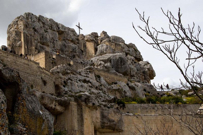
Matera
We boldly and unscrupulously switch between the epochs of mankind.
Today, with full enthusiasm, we landed in the Neolithic at the Sassi di Matera, a cave settlement of our ancestors. If you look closely, you can still discover human lives in these dwellings - and imagine, they can even use cell phones.
Of course, we also follow the tourist trail and notice that the Way of the Cross seems to have been designed here with posters of Michelangelo's works, to match the Passion of Christ. For a long time, our photo tour has been accompanied by solemn, classical music that spreads across the gorge like fog in November.
In order to be able to follow this inviting Holy Week meditation even longer, we linger for a while in a small coffee house with an espresso with a view of the massive landscape.
Matera, Italien
40° 26' 51.5" N 16° 28' 24.9" E
40.4476419 16.4735738
• Head southeast. Go for 5.0 km.
• Turn right onto Strada Statale Basentana (SS407). Go for 27.8 km.
• Take ramp onto Strada Statale Jonica (SS106) toward Reggio C./A3/Scanzano J./Policoro. Go for 81.4 km.
• Continue on SS106radd. Go for 2.1 km.
• Keep left onto SS106radd. toward Reggio Calabria/Catanzaro/Corigliano C./Cosenza/Rossano/Calabro. Go for 9.5 km.
• Pass 19 roundabouts and continue on Contrada Gangemi (SS106). Go for 81.6 km.
• Continue straight ahead. Go for 63 m.
• Take the 2nd exit from roundabout toward Crotone/Reggio C. Go for 93 m.
• Continue on Contrada Frasso. Go for 36 m.
• Keep right onto SS106 toward S. Nicola/Strongoli/Savelli/Verzino/Casabona/Pallagorio/Crotone. Go for 6.3 km.
• Turn right onto SP22 toward Rocca di Neto. Go for 513 m.
• Continue on Contrada Cantorato (SP22). Go for 1.3 km.
• Continue on SP22. Go for 35 m.
• Continue on Contrada Cantorato (SP22). Go for 750 m.
• Continue on SP22. Go for 2.0 km.
• Continue on Iannello (SP22). Go for 296 m.
• Continue on SP22. Go for 1.3 km.
• Continue on Contrada Foresta. Go for 65 m.
• Turn left toward Strada Statale Silana Crotonese/SS107. Go for 167 m.
• Turn left and take ramp onto Strada Statale Silana Crotonese (SS107). Go for 3.6 km.
• Turn right. Go for 166 m.
• Arrive at your destination.
☍
224,1 km
(3 hrs. 15 min.)
Crotone, Calabria, Italy
Silana Crotonese, 88821, Crotone, Italy
39° 8' 18.9" N 17° 3' 2.8" E
39.1385820 17.0507813
• Head toward Strada Statale Silana Crotonese. Go for 166 m.
• Turn right onto Strada Statale Silana Crotonese (SS107). Go for 4.8 km.
• Take the 2nd exit from roundabout onto SS106 toward Reggio Cal./Catanzaro/Crotone Centro. Go for 6.7 km.
• Pass 9 roundabouts and continue on SS106. Go for 40.5 km.
• Take the 2nd exit from roundabout onto Viale Venezia toward Crotone. Go for 956 m.
• Turn left onto Viale Carrao. Go for 147 m.
• Turn right onto Viale Capri. Go for 369 m.
• Turn slightly left onto Viale Capri. Go for 135 m.
• Arrive at Viale Capri. Your destination is on the right.
☍
53,7 km
( 50 min.)
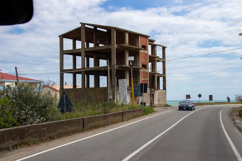
Cropani Marina, Italien
When it rains, we turn our backs on Matera and move further south. But even rain has its own charm. The view through the windscreen of our WOMO is like a television screen, on which atmospheric snapshots of a landscape appear, then immediately disappear and are replaced by the next.
Monumental buildings can be seen in the distance if you look carefully. Building skeletons appear more and more frequently on the side of the road, probably waiting in vain for their completion.
Arrived in Cropani Marina , the rain has already cleared and we experience a wonderful, relaxing end to the day with an evening atmosphere on the beach.
Cropani Marina, Cropani, Italien
38° 54' 40.5" N 16° 48' 43.7" E
38.9112509 16.8121366
• Head southeast on Viale Capri.
• Turn right onto Viale Capri. Go for 48 m.
• Turn right onto Viale Le Castella. Go for 201 m.
• Turn right onto Viale Venezia. Go for 1.4 km.
• Take the 2nd exit from roundabout onto Via Nazionale (SS106) toward Catanzaro. Go for 5.4 km.
• Pass 3 roundabouts and continue on Via Nazionale (SS106). Go for 8.2 km.
• Take the 1st exit from roundabout onto SP16 toward Salerno-Reggio C./A3/Catanzaro/Reggio C./SS106var/A. Go for 980 m.
• Take ramp toward Reggio C./SS106var/A/SA-RC/A3/Aeroporto. Go for 532 m.
• Continue on SS106var/A. Go for 7.8 km.
• Take ramp toward Salerno/A3/Reggio C./Catanzaro Ovest. Go for 572 m.
• Take ramp onto Strada Statale di Germaneto (SS280dir) toward Catanzaro Ovest/Salerno Reggio Calabria/A3. Go for 4.6 km.
• Take left ramp onto SS280 toward SA-RC/A3/Caraffa/Lamezia T. Go for 27.9 km.
• Take ramp onto A2 (Autostrada del Mediterraneo) toward Salerno/Reggio C./Reggio Calabria. Go for 18.9 km.
• Take the exit toward Pizzo Calabro/Pizzo/Tropea/Reggio C./Vibo Valentia. Go for 697 m.
• Continue on Strada Statale Tirrena Inferiore (SS18). Go for 9.5 km.
• Turn right onto SS182 toward Tropea/Vibo Marina. Go for 4.2 km.
• Take ramp onto SS522. Go for 3.8 km.
• Pass 5 roundabouts and continue on SS522. Go for 19.6 km.
• Take ramp. Go for 199 m.
• Turn left toward Contrada Fontana Nuova. Go for 63 m.
• Continue on Contrada Fontana Nuova. Go for 53 m.
• Turn right onto Viale Pietro I Ruffo di Calabria (SP17). Go for 43 m.
• Turn left onto Via Accademia degli Affaticati. Go for 78 m.
• Turn left onto Via Gerhard Rohlfs. Go for 62 m.
• Turn right onto Via Domenico Arena. Go for 84 m.
• Turn right onto Viale Tondo. Go for 54 m.
• Turn left onto Via Lorenzo Calogero. Go for 111 m.
• Turn right onto Viale Coniugi Crigna. Go for 17 m.
• Arrive at Viale Coniugi Crigna. Your destination is on the left.
☍
115,2 km
(1 hrs. 37 min.)
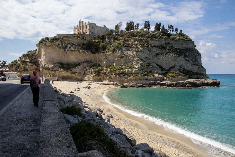
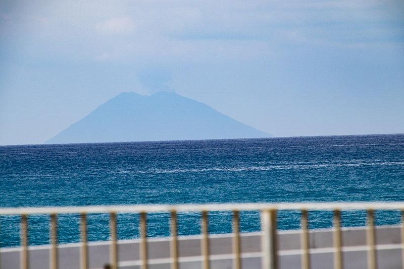
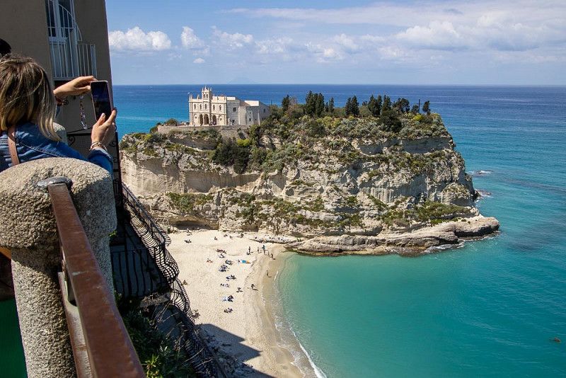
Tropea, Italien
We end up at a campsite near Soverato . The driveway over bumpy, winding roads, or rather dirt roads, is well signposted, but quite adventurous, because our WOMO had to bravely resist falling into its individual parts. Our pitch near the beach turned out to be all the nicer. Sand, sea, the sound of waves - we love this ambience and go for a long walk.
Tropea is one worth the trip. The next morning we pack our seven things to make sure they are unbreakable and shockproof and drive there on a winding, mountain and valley road. A view of the azure blue sea or the green slopes on the mountain side inspires us again and again.
The city of Tropea is built on tufa rock and requires extensive protection to protect the buildings from falling. The tourist magnet next to the old town is the church of Santa Maria dell Isola. Built on a rock by the sea, it has kept a watchful eye on the city from up there for centuries.
In the haze on the horizon, the volcano Stromboli is barely visible in the sky today. The natural spectacle of his fire-breathing behavior can be admired on well-known dates. We probably won't be able to witness that.
Tropea, 89861, Italien
38° 40' 31.4" N 15° 53' 41.3" E
38.6753790 15.8947920
• Head toward Via Piave on Viale Coniugi Crigna. Go for 99 m.
• Turn right onto Via G. Tocco. Go for 121 m.
• Turn right onto Largo 24 Casali. Go for 218 m.
• Turn slightly right onto Via Accademia degli Affaticati. Go for 11 m.
• Turn right onto Viale Pietro I Ruffo di Calabria (SP17). Go for 43 m.
• Turn left onto Contrada Fontana Nuova. Go for 116 m.
• Turn right and take ramp onto SS522. Go for 311 m.
• Continue on Galleria Sant'Angelo (SS522). Go for 554 m.
• Continue on SS522. Go for 712 m.
• Take the 1st exit from roundabout onto SS522. Go for 89 m.
• Take the 3rd exit from roundabout onto Viale Don Mottola (SP20). Go for 519 m.
• Continue on SP20. Go for 1.7 km.
• Turn right toward SP20. Go for 34 m.
• Turn right onto Strada Provinciale Drapia Ciaramiti (SP20). Go for 1.2 km.
• Turn left onto Strada Provinciale Spilinga Tropea (SP22). Go for 2.3 km.
• Turn left onto Strada Provinciale Spilinga Tropea (SP22). Go for 4.4 km.
• Turn right onto Via Monaci. Go for 809 m.
• Continue on Strada Provinciale Spilinga Tropea (SP22). Go for 916 m.
• Continue on SP22. Go for 241 m.
• Take the 1st exit from roundabout onto SP22. Go for 405 m.
• Continue on Via 20 Settembre (SP22). Go for 83 m.
• Turn right onto Via Provinciale (SP23). Go for 1.4 km.
• Continue on SP23. Go for 824 m.
• Continue on Via Provinciale (SP23). Go for 1.1 km.
• Continue on SP23. Go for 2.8 km.
• Continue toward Contrada Fontanelle. Go for 592 m.
• Continue on Contrada Fontanelle. Go for 143 m.
• Continue on Contrada Rocola. Go for 670 m.
• Turn right onto Contrada Pozzo (SP23). Go for 671 m.
• Turn right onto Contrada Oliveto Prima. Go for 554 m.
• Continue on San Bruno Melia. Go for 357 m.
• Continue on Contrada San Bruno Melia. Go for 323 m.
• Turn left. Go for 478 m.
• Arrive at your destination.
☍
24,8 km
( 37 min.)
Nicotera
Italy
38° 32' 8" N 15° 53' 11.7" E
38.5355461 15.8865759
• Head north. Go for 478 m.
• Turn right onto Contrada San Bruno Melia. Go for 323 m.
• Continue toward San Bruno Melia. Go for 187 m.
• Continue on San Bruno Melia. Go for 170 m.
• Turn right onto Contrada Siroto Seconda. Go for 637 m.
• Turn left onto Contrada Siroto Prima (SP23). Go for 430 m.
• Continue on SP23. Go for 63 m.
• Continue on Contrada Siroto Prima (SP23). Go for 423 m.
• Continue on SP23. Go for 2.7 km.
• Turn right toward Via Madonna della Grazie/SP35. Go for 983 m.
• Turn right onto Via Madonna della Grazie (SP35). Go for 156 m.
• Continue on Viale Madonna delle Grazie (SP35). Go for 1.5 km.
• Continue on SP35. Go for 57 m.
• Continue on Viale Madonna delle Grazie (SP35). Go for 1.3 km.
• Keep right onto SP36. Go for 4.6 km.
• Turn right onto SP50. Go for 2.9 km.
• Turn left onto Via Provinciale Est (SP51). Go for 981 m.
• Turn right. Go for 112 m.
• Take left ramp. Go for 3.0 km.
• Take ramp toward Gioia Tauro. Go for 290 m.
• Turn left onto Strada Statale Tirrena Inferiore (SS18) toward Gioia Tauro. Go for 6.8 km.
• Turn right onto Via Rosarno toward Centro. Go for 363 m.
• Continue on Via Catanzaro. Go for 106 m.
• Turn left onto Via Tre Palmenti. Go for 199 m.
• Take the 1st exit from roundabout onto Via Pozzillo. Go for 358 m.
• Arrive at Via Pozzillo. Your destination is on the left.
☍
29,1 km
( 34 min.)
Bagnara Calabra
89013, Italy
38° 26' 11" N 15° 54' 7.3" E
38.4363846 15.9020345
• Head south on Via Pozzillo. Go for 348 m.
• Take the 2nd exit from roundabout. Go for 79 m.
• Continue on Via Tre Palmenti. Go for 141 m.
• Turn right onto Via Catanzaro. Go for 106 m.
• Continue on Via Rosarno. Go for 363 m.
• Turn right onto Strada Statale Tirrena Inferiore (SS18). Go for 1.2 km.
• Take the 3rd exit from roundabout onto Strada Provinciale di Gioia Tauro e Locri (SS111) toward Autostrada/Locri/Taurianova/Delianova. Go for 2.2 km.
• Take the 4th exit from roundabout onto A2 (Autostrada del Mediterraneo) toward SA-RC. Go for 35.9 km.
• Keep right toward Villa S. Giovanni. Go for 2.8 km.
• Take ramp toward Villa S. Giovanni. Go for 2.2 km.
• Keep left. Go for 48 m.
• Turn right toward Villa S. Giovanni/Via Zanotti Bianco Centro. Go for 286 m.
• Continue on Via Guglielmo Marconi. Go for 88 m.
• Turn left onto Viale Italia. Go for 158 m.
• Turn left onto Via Giuseppe Garibaldi. Go for 69 m.
• Continue on Via dei Martiri d'Italia. Go for 278 m.
• Turn left. Go for 357 m.
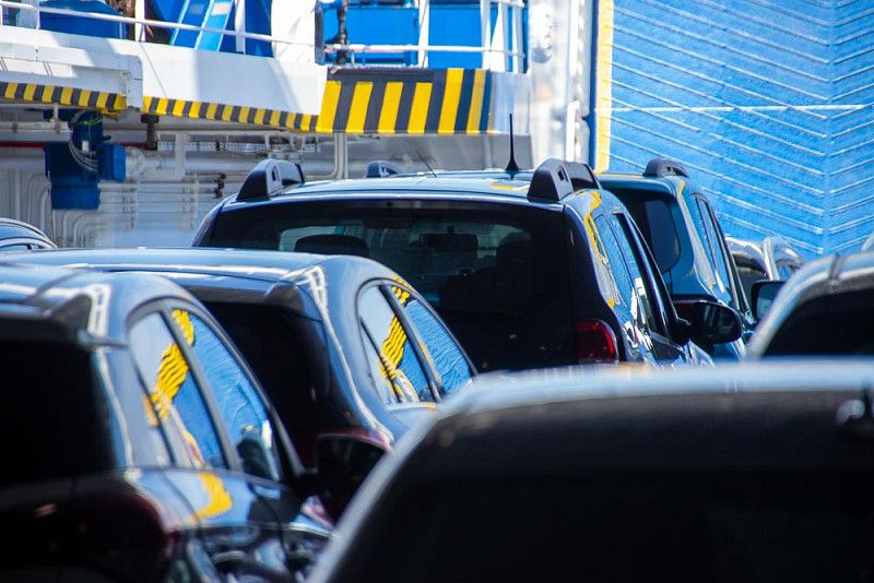
• Take the Villa San Giovanni-Messina Ferry. Stay on for 6.8 km.
• Head toward Rotonda San Francesco di Paola on Rada San Francesco. Go for 194 m.
• Continue on Imbarco Traghetti Caronte. Go for 363 m.
• Turn right toward Viale della Libertà. Go for 103 m.
• Turn left onto Viale della Libertà toward Centro/Autostrade. Go for 727 m.
• Continue on Piazza dell'Unità d'Italia. Go for 139 m.
• Keep right onto Corso Camillo Benso di Cavour toward Via Vitt. Emanuele II/Autostrade. Go for 189 m.
• Turn right onto Viale Boccetta toward Autostrade. Go for 913 m.
• Keep right toward Autostrade. Go for 222 m.
• Continue on Contrada Scoppo. Go for 495 m.
• Take ramp onto A20 (Autostrada Messina-Palermo) toward Catania. Go for 9.2 km.
• Continue on A18 (Autostrada Messina-Catania). Go for 21.8 km.
• Take the exit toward Roccalumera. Go for 819 m.
• Continue on Strada Statale Orientale Sicula (SS114) toward Catania/Furci S./S.Teresa di R./S.Alessio S./Forza d'Agrò. Go for 1.7 km.
• Continue on Via Stradella Messina toward Catania. Go for 102 m.
• Turn right onto Via Lungomare Bucalo-Centro. Go for 934 m.
• Turn right onto Via Cimitero. Go for 184 m.
• Continue on Via Roma. Go for 413 m.
• Arrive at Via Roma. Your destination is on the right.
☍
91,9 km
(1 hrs. 53 min.)
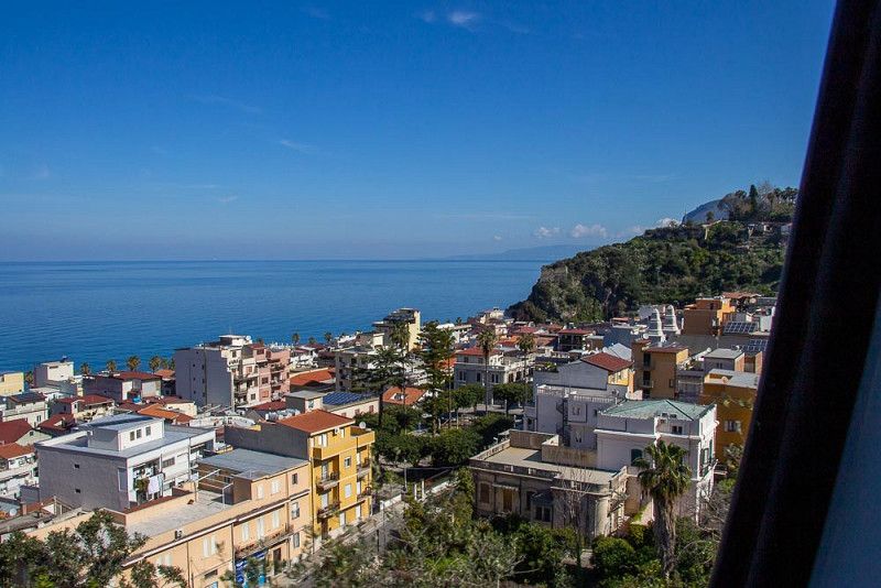
Santa Teresa di Riva, Italien
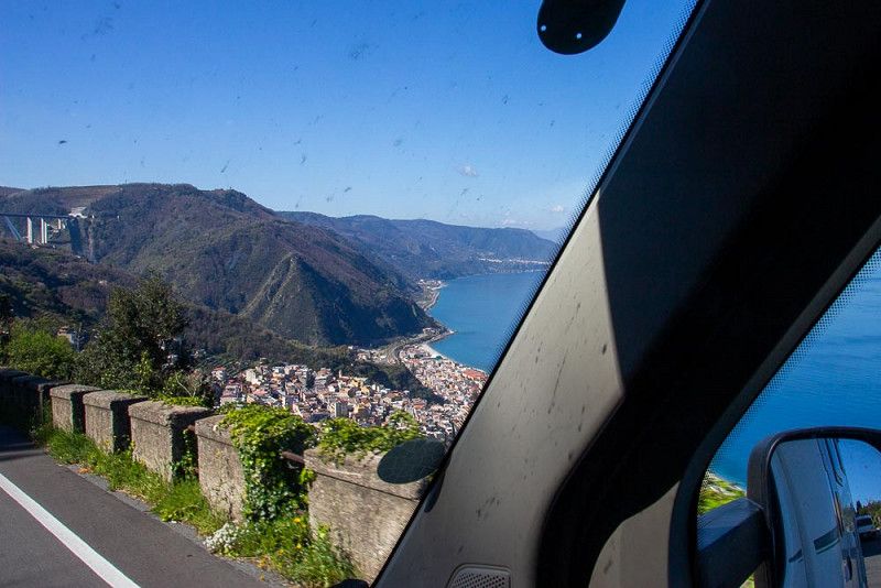
We start in high spirits early in the morning (9 a.m.) to hijack a ferry in Villa S. Giovanni for the crossing to Sicily. The arrival via the coastal road with many indescribable views of the sea and the unique landscape turns into a real adventure. We curve over a number of switchbacks, squeeze through the narrow streets of the through roads and are both busy watching out for pedestrians, cars parked in the 2nd lane and curbs so as not to touch them.
A sudden crash and my stressed pulse catapults upwards. Now what shouldn't have happened has happened. Our WOMO kissed the edge of a wall protruding into the street with the side mirror. Thank goodness nothing happened. The folded mirror was set up again, our heated tempers relaxed and we continued on the path even more attentively. The much touted Amalfi Coast probably offers a similar panorama and is probably no less of a challenge.
Finally arrived in Villa S. Giovanni we search in vain and after a few returns for the port. We can only do that using the navigation system and we check in without any problems.
After the short crossing and a muddle through Messina , we end up tired and in need of rest at the campsite in Santa Teresa di Riva .
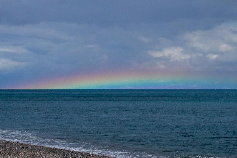
Easter Sunday - we will relax today and go out for a nice meal in holiday clothes. And because heaven is kind to us, it presents us with a magnificent rainbow over the opposite mainland as a sign of resurrection.
Santa Teresa di Riva, 98028, Italien
37° 56' 49.1" N 15° 22' 3.7" E
37.9469620 15.3676890
• Head toward Via Camillo Benso di Cavour on Via Roma. Go for 193 m.
• Turn left onto Via delle Colline. Go for 160 m.
• Turn left onto Via delle Colline. Go for 43 m.
• Turn right onto Via Trento. Go for 89 m.
• Turn left onto Via Ugo Foscolo. Go for 34 m.
• Turn right onto Via Francesco Crispi (SS114). Go for 32 m.
• Turn left onto Via del Gambero. Go for 78 m.
• Turn right onto Viale Fratelli Lo Schiavo. Go for 1.2 km.
• Continue on Via Torrente Agrò. Go for 279 m.
• Take the 3rd exit from roundabout onto Bretella Agrò. Go for 193 m.
• Continue on Contrada Siena. Go for 60 m.
• Turn left onto Via Mantineo. Go for 233 m.
• Continue on Via Nazionale (SP12). Go for 9.9 km.
• Turn right toward Messina-Catania/A18/E45/Taormina/Castelmola/SP10. Go for 240 m.
• Turn sharp right toward Taormina/Castelmola/SP10. Go for 151 m.
• Continue on Via Mario e Nicolò Garipoli. Go for 2.4 km.
• Take the 2nd exit from roundabout onto Via Mario e Nicolò Garipoli. Go for 298 m.
• Continue on Viale San Pancrazio. Go for 495 m.
• Turn slightly left onto Corso Umberto I. Go for 92 m.
• Continue on Corso Umberto I. Go for 344 m.
• Arrive at Corso Umberto I. Your destination is on the right.
☍
16,5 km
( 28 min.)
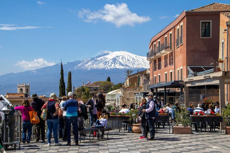
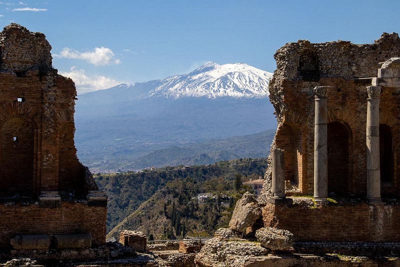
Taormina, Italien
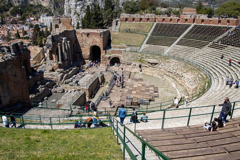
Taormina is on our program today. We choose a public bus to save us driving through the narrow streets and looking for a parking space. The driver masters the inevitable obstacles in a routine manner - for me this journey is just as stressful as visiting a rollercoaster.
The path through the old town of Taormina is a pilgrimage of many people from all over the world who are interested in the history of antiquity and want to visit the teatro antico di Taormina .
We also appear on the stage. I have the vain impression that the visitors in the stands are already waiting for my performance. Unfortunately, I have to acknowledge that Mount Etna , the proud and majestic protagonist of this spectacle, delights the crowd in the background behind me.
I, too, look at this phenomenon with humility. I take a seat in the auditorium and try to beam my thoughts back to the times of the Greeks and Romans.
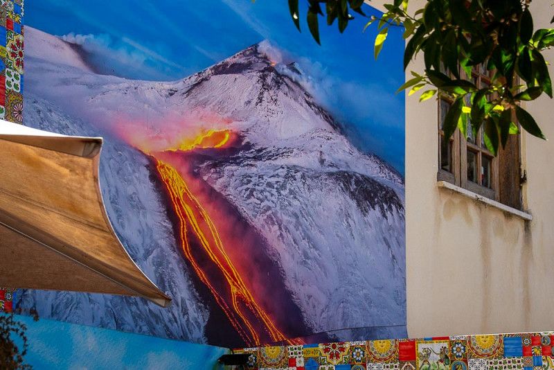
After that, it's time to seek rest. We find her in a small, secluded restaurant, where we dine to the sounds of "O sole mio" and the jasmine-like scent of orange blossoms. In addition to the stylish furnishings, we discover a mural depicting Mount Etna with its diabolical power, when it breathes fire and pours a stream of lava over its slope.
Taormina, 98039, Italien
37° 51' 6.5" N 15° 17' 8.3" E
37.8517921 15.2856523
• Head toward Via Sesto Pompeo on Corso Umberto I. Go for 395 m.
• Continue on Piazza Sant'Antonio Abate. Go for 30 m.
• Turn slightly right onto Via Crocifisso. Go for 99 m.
• Take the 2nd exit from roundabout onto Via Crocifisso. Go for 420 m.
• Turn left onto Via Calvario. Go for 529 m.
• Turn left onto Via Crocifisso. Go for 307 m.
• Turn left onto Via Crocifisso. Go for 471 m.
• Turn right onto Via Nazionale (SS114). Go for 2.5 km.
• Turn left and take ramp onto SS185 toward E45/Messina/A18/Catania/Novara Sic./Francavilla S./Gaggi/Trappitello. Go for 771 m.
• Keep left onto SS185 toward Strada Statale di Sella Mandrazzi/Francavilla di Sic./Novara di Sic. Go for 5.6 km.
• Turn left onto Corso Delle Province (SS185). Go for 50 m.
• Take the 1st exit from roundabout onto Corso Delle Province (SP8). Go for 774 m.
• Continue on SP8. Go for 633 m.
• Turn right onto SP81. Go for 3.5 km.
• Continue on Via Volta Pafumi (SP81). Go for 2.4 km.
• Arrive at Via Volta Pafumi (SP81). Your destination is on the right.
☍
18,5 km
( 35 min.)
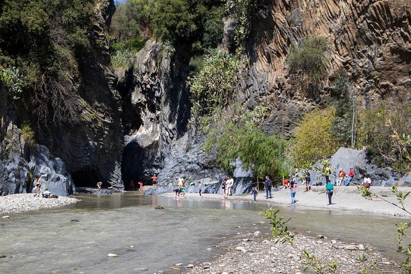
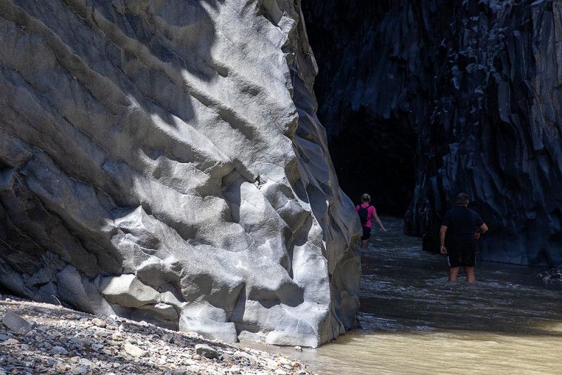
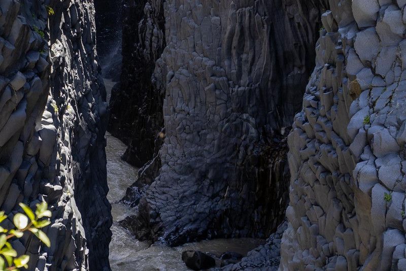
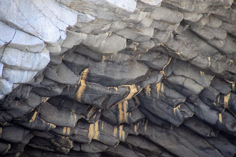
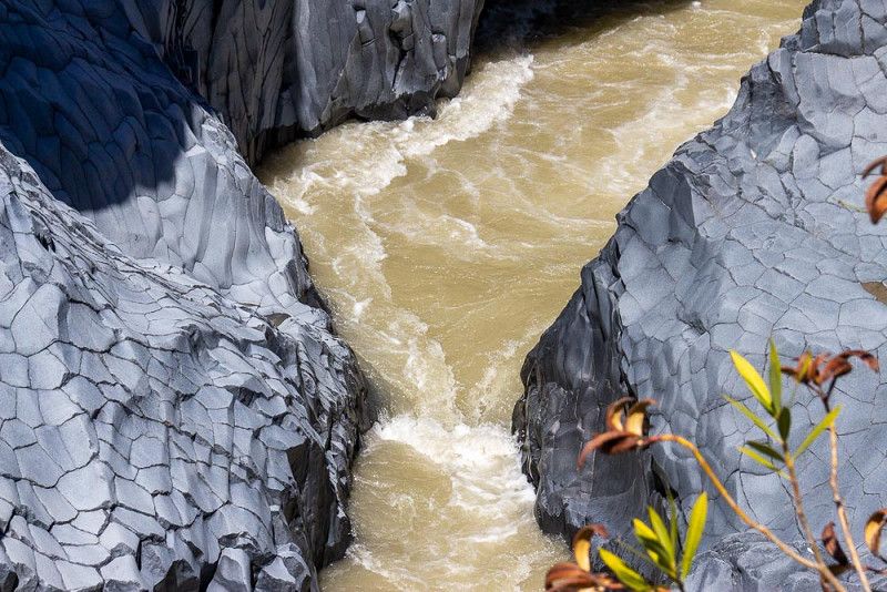
Gole dell'Alcantara, Italien
Gole dell'Alcantara, the Alcatara Gorge is on our way to the next campsite, which is very promising in the surroundings of a wine-growing region at the foot of Mount Etna.
For a hike into a gorge, we know that you need hiking boots and a minimum supply of food and drinks. With this outfit we leave, pay the entrance fee and are amazed that we can take a lift down and only land on a few stairs on a beach that gives us an insight into the narrowness and mightiness of the gorge with the basalt columns towering up on the sides . The architect Etna designed the structure of the rock walls over thousands of years with his eruptions. We definitely want to see more of that and briskly climb the stairs that lead us to a hiking trail on the "mountain crest". Some vantage points give us the chance to look down where a river, fed by small waterfalls, pushes towards its exit from the narrows.
Our presumed hiking tour turned out to be just a nice walk, but it was worth it.
Gole dell'Alcantara, 98030, Italien
37° 52' 48.4" N 15° 10' 23.4" E
37.8801119 15.1731702
• Head southeast on Via Volta Pafumi (SP81). Go for 2.4 km.
• Continue on SP81. Go for 6.9 km.
• Continue on Via Alcantara (SP81). Go for 479 m.
• Continue on Piazza Vittorio Emanuele (SP81). Go for 69 m.
• Turn right onto Piazza Vittorio Emanuele (SP1III). Go for 81 m.
• Continue on Via Umberto I (SP1III). Go for 1.8 km.
• Turn right onto Via Pasteria (SS114). Go for 478 m.
• Turn left onto Via Lapide Vecchia. Go for 47 m.
• Turn right onto Via Torrente Zampataro. Go for 124 m.
• Continue on Via Lapide Vecchia (SP186). Go for 1.9 km.
• Continue on Strada Statale dell'Etna e delle Madonie (SS120) toward Catania/A18/Messina/Piedimonte E./Randazzo. Go for 392 m.
• Take the 3rd exit from roundabout toward E45/Messina/A18/Catania/Autostrada. Go for 588 m.
• Take ramp onto A18 (Autostrada Messina-Catania) toward Catania. Go for 28.5 km.
• Continue on RA15 (Tangenziale di Catania). Go for 3.2 km.
• Take the exit toward Gravina onto Via Etnea. Go for 570 m.
• Continue toward Via Etnea/SP10var. Go for 51 m.
• Take the 4th exit from roundabout onto Via Etnea (SP10var). Go for 516 m.
• Turn right onto Via Etnea (SP10var). Go for 887 m.
• Continue on Via Etnea (SP10var). Go for 2.4 km.
• Turn left onto Via Etnea (SP10var). Go for 39 m.
• Turn right onto Via Etnea (SP10var). Go for 505 m.
• Take the 2nd exit from roundabout onto Via Etnea (SP10var). Go for 629 m.
• Continue on Via del Bosco (SP10var). Go for 572 m.
• Turn left onto Via Mompilieri (SP171). Go for 3.1 km.
• Take the 4th exit from roundabout onto SP171. Go for 368 m.
• Take the 1st exit from roundabout onto Via Fornace (SP171). Go for 368 m.
• Turn left onto Via Guglielmo Marconi (SP4ii). Go for 454 m.
• Continue on SP4ii. Go for 187 m.
• Take the 1st exit from roundabout onto SP4ii. Go for 707 m.
• Continue on Via Nicolosi (SP4ii). Go for 419 m.
• Continue on SP4ii. Go for 127 m.
• Arrive at SP4ii. Your destination is on the left.
☍
58,8 km
(1 hrs. 4 min.)
Mons Gibel Camping Park
Mount Etna in its elemental appearance is a dominant goal of our journey . The original plan to circumnavigate the volcano with the Circumetnabahn cannot be realized for organizational reasons. So our WOMO has to take over this task. We can see the mountain from all sides from the car and are impressed by the many faces. We are also following the outgrowths of past eruptions with great attention, in which huge lava flows have rolled into the settlement area and thus also up to the road. On the one hand devastating, on the other hand stimulating, as can be seen from the structure of the landscape.
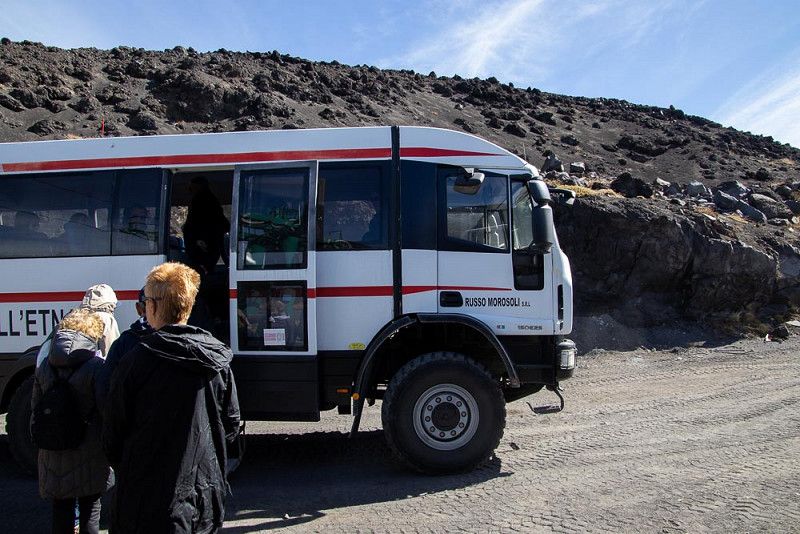
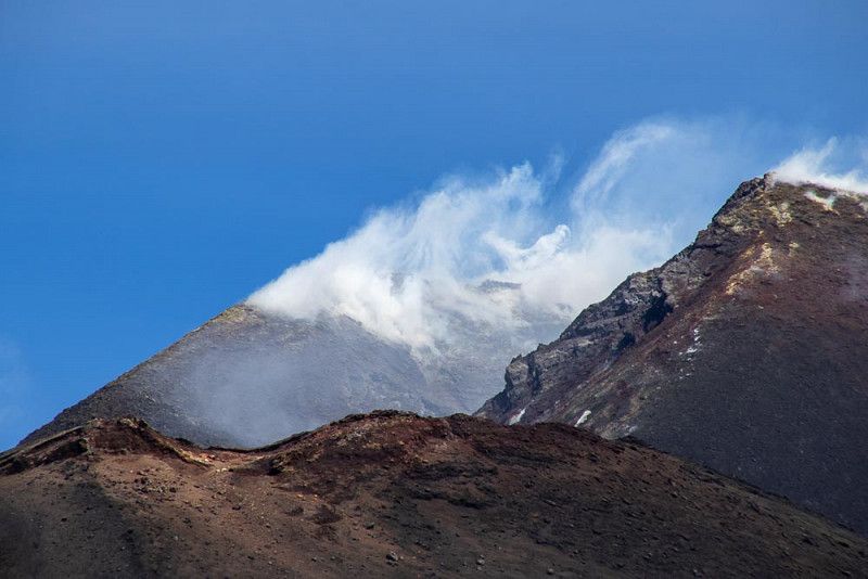
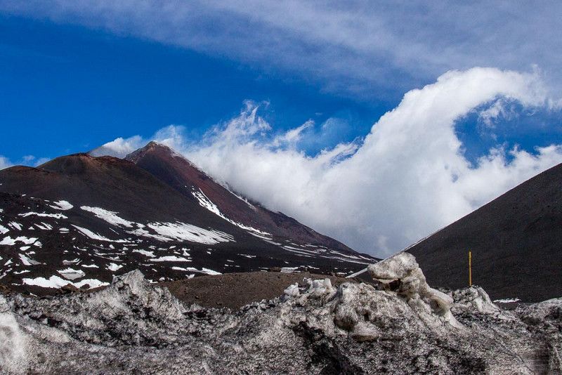
When we checked in at our campsite, we found out that we could get even closer to our destination with a shuttle bus. There's no question - we'll go with you to the cable car station, which we can use to reach the summit without much effort. We are carted uphill in a four-wheel drive bus because the cable car is still in sleep mode. It doesn't matter - it goes up and we are awaited there by an indescribably attractive backdrop. Clear view of the old Smoker Etna, which is constantly puffing clouds of smoke into the sky. With 3 357m the highest, still active volcano in Europe placed amidst solidified lava and ice. Unforgettable!
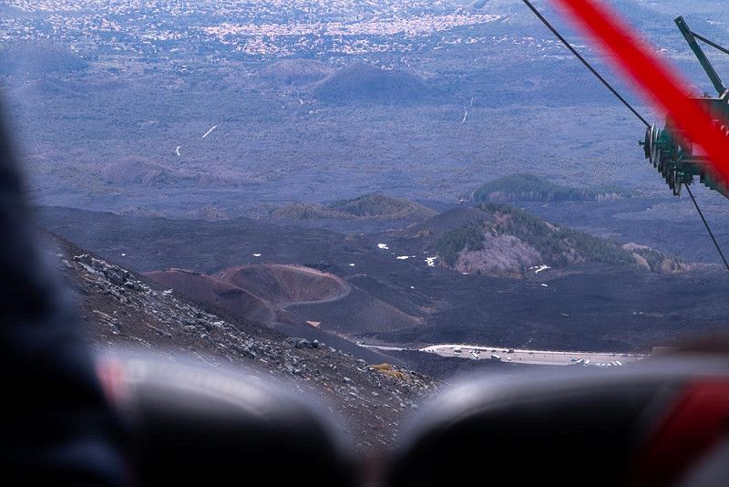
The downhill can then be done with the cable car. The advantage here is the unrestricted view of already extinct craters and the timid growth of the nutrient-rich soil on the slopes below us.
Via Nicolosi, SP 4/11, 95032, Belpasso, Italy
37° 36' 31.1" N 14° 59' 52.5" E
37.6086300 14.9979200
• Head toward Strada Vicinale Piscitello on SP4ii. Go for 127 m.
• Continue on Via Nicolosi (SP4ii). Go for 419 m.
• Continue on SP4ii. Go for 701 m.
• Take the 2nd exit from roundabout onto SP4ii. Go for 217 m.
• Continue on Via Guglielmo Marconi (SP4ii). Go for 454 m.
• Turn right onto Via Fornace (SP171). Go for 362 m.
• Take the 2nd exit from roundabout onto SP171. Go for 339 m.
• Take the 1st exit from roundabout onto Via Mompilieri (SP171). Go for 3.1 km.
• Turn right onto Via del Bosco (SP10var). Go for 572 m.
• Continue on Via Etnea (SP10var). Go for 582 m.
• Take the 3rd exit from roundabout onto Via San Giovanni. Go for 501 m.
• Continue toward Via Alcide De Gasperi/SP10. Go for 39 m.
• Take the 2nd exit from roundabout onto Via Alcide De Gasperi (SP10). Go for 1.3 km.
• Take the 3rd exit from roundabout onto Via Alcide De Gasperi (SP10). Go for 244 m.
• Pass 2 roundabouts and continue on Via Antonio Gramsci (SP10). Go for 1.3 km.
• Take the 3rd exit from roundabout onto Via Antonio Gramsci (SP10). Go for 499 m.
• Pass 2 roundabouts and continue on Via Antonio Gramsci (SP10). Go for 1.2 km.
• Take the 3rd exit from roundabout onto Via Etnea. Go for 357 m.
• Take the 2nd exit from roundabout onto Via Etnea. Go for 158 m.
• Turn left and take ramp onto RA15 (Tangenziale di Catania) toward Messina/A18. Go for 3.6 km.
• Continue on A18 (Autostrada Messina-Catania) toward Messina. Go for 76.7 km.
• Continue on A20 (Autostrada Messina-Palermo) toward Palermo/E90/Messina Boccetta/Messina Centro/Messina Gazzi/Messina San Filippo. Go for 8.9 km.
• Take the exit toward Messina Boccetta/Traghetti. Go for 932 m.
• Continue on Contrada Scoppo. Go for 277 m.
• Continue on Viale Boccetta. Go for 1.0 km.
• Turn right onto Via Vittorio Emanuele II. Go for 998 m.
• Continue on Via Luigi Rizzo. Go for 368 m.
• Continue on Marittima. Go for 46 m.
• Turn left. Go for 35 m.
• Take the Messina-Villa San Giovanni Ferry. Stay on for 8.2 km.
• Head southeast. Go for 272 m.
• Continue on Piazzale Stazione Imbarco Automezzi. Go for 153 m.
• Continue toward Autostrada del Mediterraneo/A2. Go for 1.2 km.
• Take ramp onto A2 (Autostrada del Mediterraneo) toward Salerno. Go for 127 km.
• Take the exit toward Falerna/Nocera T./SP164. Go for 512 m.
• Take the 2nd exit from roundabout onto SS18dir toward Falerna/Gizzeria/Amantea/Paola. Go for 829 m.
• Turn right onto Località Cartolano (SS18) toward Salerno/Amantea/Paola. Go for 14.5 km.
• Take the 2nd exit from roundabout onto Strada Statale Tirrena Inferiore (SS18). Go for 27.6 km.
• Turn right toward Cosenza/SA-RC/A3. Go for 37 m.
• Continue on Via della Sila (SS107). Go for 24.5 km.
• Take ramp onto Via Guglielmo Marconi toward SA-RC/A3/Stazione Castiglione C. Go for 543 m.
• Continue toward Salerno/A3/Reggio C. Go for 76 m.
• Take the 1st exit from roundabout toward Salerno/Reggio C. Go for 51 m.
• Continue toward Autostrada del Mediterraneo/A2. Go for 106 m.
• Take ramp onto A2 (Autostrada del Mediterraneo) toward Salerno. Go for 247 km.
• Continue on A3 (Autostrada Salerno-Reggio Calabria) toward Salerno/Napoli. Go for 32.4 km.
• Take the exit toward Pompei Scavi onto Svincolo Pompei. Go for 402 m.
• Turn right onto Piazza Porta Marina Inferiore. Go for 42 m.
• Turn left onto Via Plinio. Go for 564 m.
• Take the 2nd exit from roundabout onto Via Plinio. Go for 518 m.
• Continue on Piazza Immacolata. Go for 77 m.
• Turn left onto Piazza Anfiteatro. Go for 86 m.
• Arrive at Piazza Anfiteatro.
☍
591,9 km
(6 hrs. 31 min.)
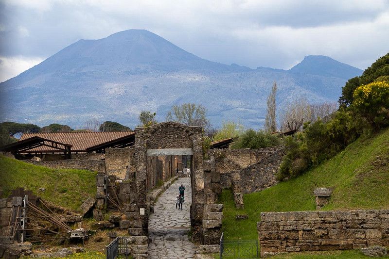
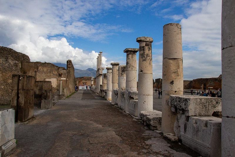
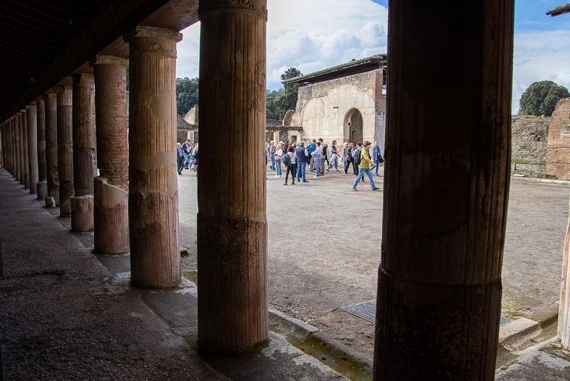
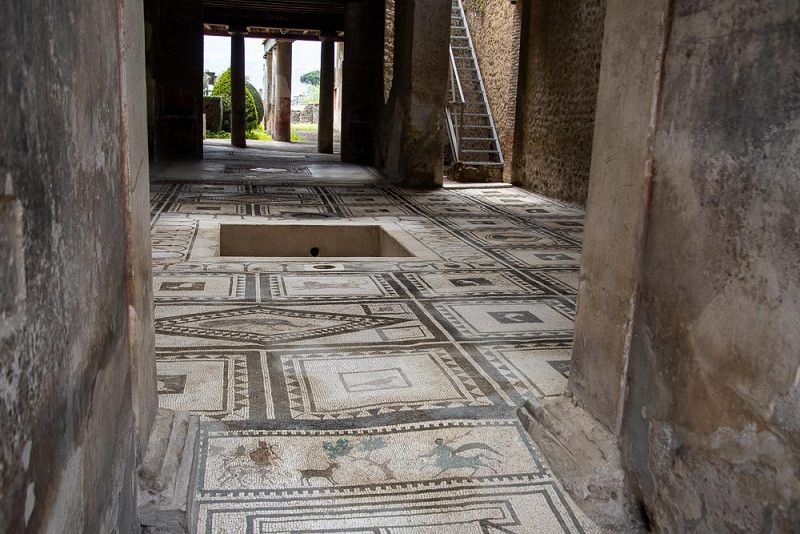
Antikes Pompeji, Italien
After a stopover and a regeneration shopping day in rainy weather, we are now ready for an extensive tour of the archaeological excavations in Pompeii.
We know that almost 2000 years ago the volcano Vesuvius buried the then very prosperous city with its ejection of lava and rock in an oversized, frenzied outburst of anger and covered it with a meter-high, preserving layer of ash. Most people had no time to get to safety, were killed alive by falling walls, burned or suffocated. An entire culture was wiped out.
Today we walk through a part of the exposed ancient city and try to imagine the hustle and bustle in the streets or life in the villas. Others crowd along with us on these paths, countless paparazzi shoot insatiable photos to capture the unique, sometimes playful architecture. The preservation of this huge archaeological site is certainly an elaborate challenge to protect it from destructive environmental influences.
The display of three human figures behind a glass front makes me pause briefly - a minute's silence for the victims who were unable to escape their fate at the time.
Antikes Pompeji, 80045, Pompei, Italien
40° 45' 6.3" N 14° 29' 26" E
40.7517375 14.4905636
• Head west on Piazza Anfiteatro. Go for 82 m.
• Turn right onto Via Plinio. Go for 486 m.
• Take the 1st exit from roundabout onto Viale Giuseppe Mazzini. Go for 580 m.
• Turn right onto Piazza Porta Marina Inferiore toward Napoli. Go for 42 m.
• Turn left onto Svincolo Pompei toward A3. Go for 272 m.
• Take ramp onto A3 (Autostrada Napoli-Salerno). Go for 18.0 km.
• Continue on E45 toward Caserta-Roma/A1/E842/Avellino/A16/Bari/A14/Tangenziale/Aeroporto. Go for 854 m.
• Continue on A1 (Autostrada del Sole). Go for 268 km.
• Take the exit toward Orte/Perugia/Terni/Narni/Flaminia/SS3. Go for 455 m.
• Continue on E45. Go for 929 m.
• Take ramp onto Strada Statale Umbro-Laziale (SS675). Go for 20.0 km.
• Take ramp onto Strada Statale Tiberina (SS3bis) toward Perugia/Cesena. Go for 69.4 km.
• Keep left onto Strada Statale Tiberina (SS3bis) toward Assisi/Cesena. Go for 3.8 km.
• Take ramp onto Strada Statale Centrale Umbra (SS75) toward Assisi/Foligno/Spoleto/Aeroporto. Go for 3.8 km.
• Take ramp onto Via Giulio Caldarelli toward Ospedalicchio Sud/Ospedalicchio/Perugia/Aeroporto. Go for 418 m.
• Continue on Strada Comunale di Serre. Go for 511 m.
• Take the 1st exit from roundabout onto Strada Regionale di Assisi (SR147) toward Bastia/Assisi. Go for 2.4 km.
• Take the 2nd exit from roundabout onto Strada Regionale di Assisi (SR147). Go for 5.2 km.
• Continue toward Strada Regionale di Assisi/SR147. Go for 42 m.
• Take the 2nd exit from roundabout onto Strada Regionale di Assisi (SR147). Go for 790 m.
• Take the 2nd exit from roundabout onto Viale Guglielmo Marconi. Go for 167 m.
• Continue on Piazza Giovanni Paolo II. Go for 195 m.
• Turn slightly right onto Piazzetta Ruggero Bonghi. Go for 14 m.
• Continue on Via Fontebella. Go for 382 m.
• Continue on Piazzetta Giuseppe Garibaldi. Go for 34 m.
• Turn slightly left onto Via Eugenio Brizi. Go for 60 m.
• Turn slightly left onto Via Giotto. Go for 34 m.
• Continue on Via Portica. Go for 108 m.
• Continue on Piazza del Comune. Go for 23 m.
• Arrive at Piazza del Comune. Your destination is on the left.
☍
397,2 km
(3 hrs. 32 min.)
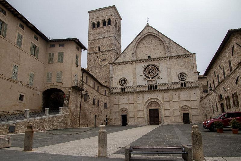
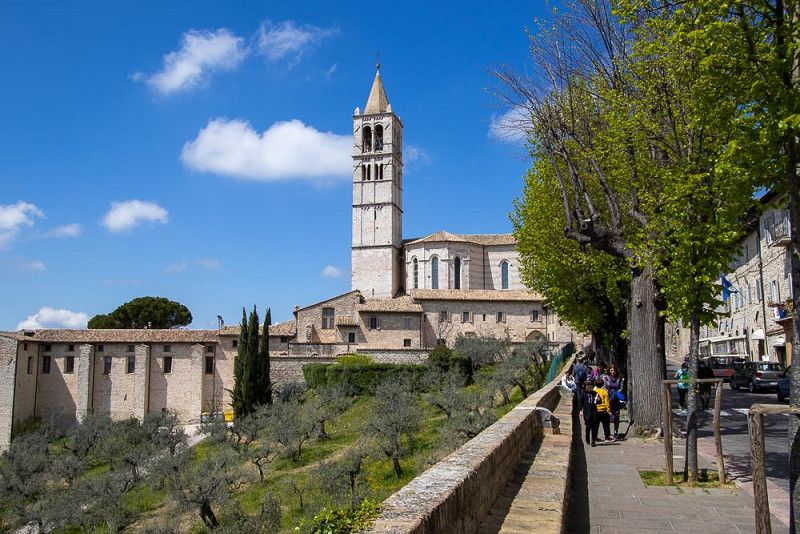
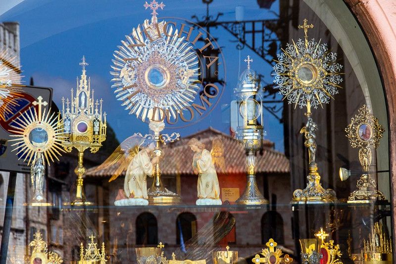
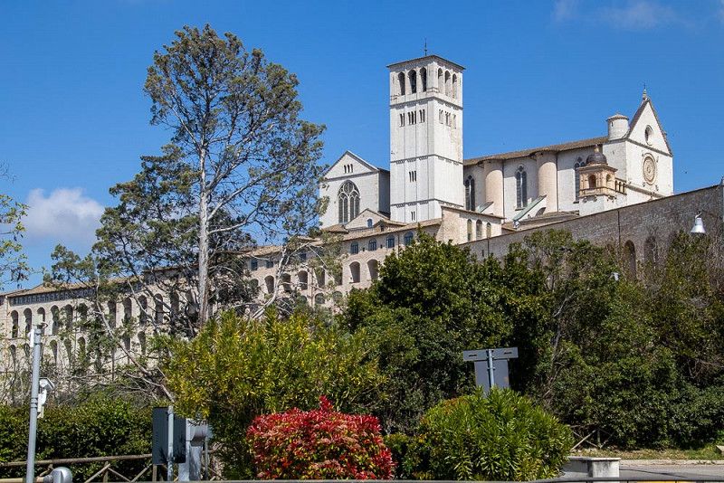
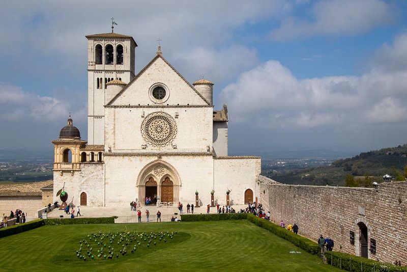
Assisi, Italien
Assisi, the place of pilgrimage for many Christians, is located in Umbria. In the city with a medieval character, we too make a pilgrimage through the historic streets from one basilica to the next, which outdo each other in size and dimensions. The glow of the saints gives these buildings a special glow. Some of the utensils for a glamorous service design shine just as brilliantly from the displays. What pomp!
The Basilica di S. Francesco marks the end of our city tour. Balanced on a massive foundation supported by semicircular arches, it lifts the church of Saint Francis of Assisi, the founder of the "Friars Minor", towards the sky.
Assisi, 06081, Italien
43° 4' 16.3" N 12° 36' 52.8" E
43.0711952 12.6146669
• Head toward Via Arco dei Priori on Piazza del Comune. Go for 27 m.
• Turn left onto Via San Gabriele dell'Addolorata. Go for 267 m.
• Continue on Via Galeazzo Alessi. Go for 179 m.
• Continue on Via Galeazzo Alessi. Go for 126 m.
• Turn left onto Piazzale Trieste (SR444). Go for 359 m.
• Turn right onto Piazza Giacomo Matteotti (SP251). Go for 278 m.
• Keep left onto Via Eremo delle Carceri (SP251). Go for 701 m.
• Continue on Via Frate Focu (SP251). Go for 2.5 km.
• Turn left onto Via Eremo delle Carceri (SP251). Go for 79 m.
• Continue on Strada Monte Subasio. Go for 1.4 km.
• Turn right onto Strada Monte Subasio. Go for 2.8 km.
• Turn right onto Strada Monte Subasio. Go for 3.7 km.
• Arrive at your destination.
☍
12,4 km
( 28 min.)
Monte Subasio, Italien
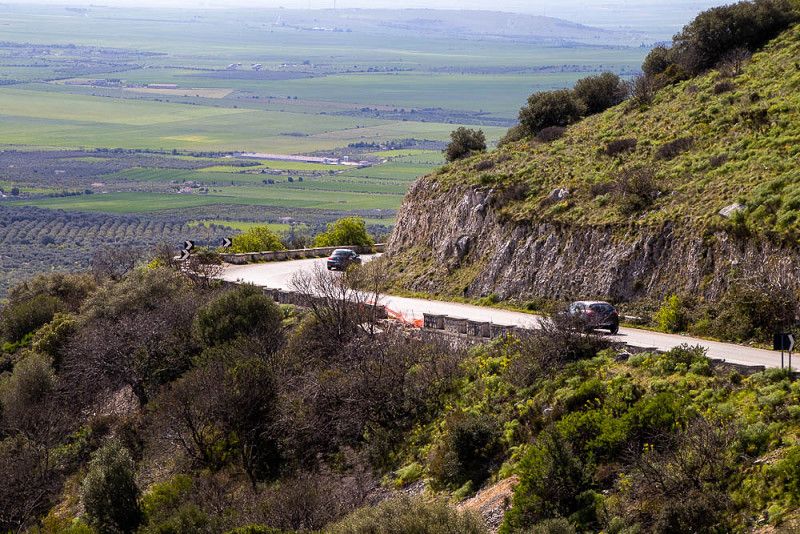
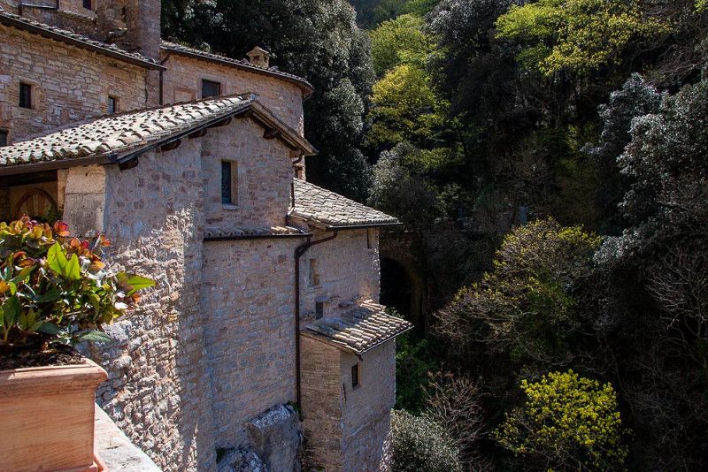
After the intensive visit to the city of Assisi, which was richly peppered with cultural highlights, today we are looking for the peace and quiet in nature, in the spirit of Francis of Assisi. We follow in the footsteps of the saint, who is now revered as Italy's patron saint of animals and the environment, and hike, carrying a backpack, to his hermitage. Here he often retreated to pray and meditate. As the founder of the order of the Friars Minor, he lived in poverty and dressed in a simple, brown robe, which is still used today by the Franciscan monks.
His ideology of protecting living beings and nature, going through the world with open eyes and striving for peace have always had a strong influence on our way of life.
We experience today's hike all the more intensively, which after the hermitage leads us further uphill through a forest towards Mt. Subasio. The music of the chirping of birds, the scent of blooming cyclamen accompany us to a welcome spot for a snack on a grassy hill, where we can see a small herd of horses in the distance. Blossoming trees and bushes, little flowers stretching towards the sun and still the melodious song of the birds. A spectacle of nature, staged just for us.
Monte Subasio, 06081, Italien
43° 3' 25.4" N 12° 40' 17.2" E
43.0570489 12.6714328
• Head west. Go for 1.9 km.
• Turn slightly right onto Strada Monte Subasio. Go for 1.8 km.
• Turn left onto Strada Monte Subasio. Go for 2.8 km.
• Turn left toward Strada Monte Subasio. Go for 12 m.
• Continue on Strada Monte Subasio. Go for 1.4 km.
• Keep right onto Via Eremo delle Carceri (SP251). Go for 79 m.
• Turn right onto Via Eremo delle Carceri (SP251). Go for 1.1 km.
• Turn left onto Via Eremo delle Carceri (SP251). Go for 1.6 km.
• Keep left onto Via Eremo delle Carceri (SP251). Go for 795 m.
• Turn left onto Piazza Giacomo Matteotti (SR444). Go for 1.2 km.
• Take the 1st exit from roundabout onto Strada Regionale di Assisi (SR147) toward Ospedale/S.M.Degli Angeli/Perugia/Roma-Firenze/A1. Go for 1.5 km.
• Take the 2nd exit from roundabout onto Strada Regionale di Assisi (SR147). Go for 778 m.
• Continue toward Perugia/A1/Foligno/SS75. Go for 33 m.
• Take the 2nd exit from roundabout onto Strada Statale di Assisi (SS147) toward Perugia/A1/Foligno/SS75. Go for 2.0 km.
• Take the 2nd exit from roundabout toward Rivotorto. Go for 219 m.
• Take the 2nd exit from roundabout toward Perugia/SS75/Foligno/Rivotorto. Go for 550 m.
• Take the 1st exit from roundabout onto Via di Valecchie toward Perugia/Foligno/Rivotorto. Go for 394 m.
• Take the 2nd exit from roundabout onto Via Francesco di Bartolo. Go for 301 m.
• Take the 2nd exit from roundabout toward Perugia/Roma/Firenze/Bastia Umbra/A1. Go for 41 m.
• Take ramp onto Strada Statale Centrale Umbra (SS75) toward Perigia. Go for 9.9 km.
• Take left ramp onto Strada Statale Tiberina (SS3bis) toward Perugia/Firenze/A1/Roma/Lago/Lago Trasimeno. Go for 3.6 km.
• Take ramp onto Raccordo Autostradale Bettolle-Perugia (RA6) toward Firenze/A1/Perugia. Go for 59.4 km.
• Keep left onto Raccordo Siena-Bettolle. Go for 15.0 km.
• Take ramp toward Asciano. Go for 183 m.
• Turn right toward Asciano/Rigomagno/Buonconvento/Arezzo. Go for 54 m.
• Turn right onto Strada Stale di Rapolano toward Buonconvento/Asciano. Go for 142 m.
• Continue on Strada Lauretana (SP438). Go for 8.7 km.
• Turn right onto Via Trento. Go for 157 m.
• Continue on Via Amendola. Go for 34 m.
• Continue on Via Trieste. Go for 131 m.
• Turn right onto Piazza Giuseppe Mazzini (SP438) toward Siena/Centro. Go for 84 m.
• Continue on Strada Comunale delle Fonti (SP438) toward Monteroni d'Arbia/Siena. Go for 920 m.
• Take the 4th exit from roundabout onto Strada Provinciale di Monte Oliveto (SP451). Go for 2.9 km.
• Continue on Podere Lucarelli (SP451). Go for 63 m.
• Continue on Strada Provinciale di Monte Oliveto (SP451). Go for 1.5 km.
• Continue on Podere Chiuse I (SP451). Go for 120 m.
• Continue on Strada Provinciale di Monte Oliveto (SP451). Go for 1.2 km.
• Continue on Podere Saltafabbro (SP451). Go for 200 m.
• Continue on Strada Provinciale di Monte Oliveto (SP451). Go for 1.0 km.
• Continue on Podere Querceto (SP451). Go for 207 m.
• Continue on Strada Provinciale di Monte Oliveto (SP451). Go for 208 m.
• Continue on Podere Chiuserra (SP451). Go for 182 m.
• Continue on Strada Provinciale di Monte Oliveto (SP451). Go for 9.6 km.
• Turn right onto Strada Regionale Cassia (SR2). Go for 3.5 km.
• Turn right onto Via Borgo del Ponte Darbia. Go for 141 m.
• Turn slightly right onto Via Borgo del Ponte Darbia. Go for 51 m.
• Arrive at Via Borgo del Ponte Darbia. Your destination is on the right.
☍
137,6 km
(2 hrs. 10 min.)
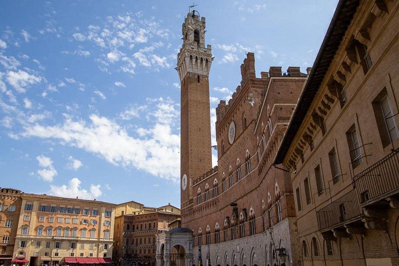
Siena, Italien
Siena , the insider tip of a camper neighbor, is said to be one of the most beautiful cities in Tuscany next to Florence. "Absolutely worth seeing!" that's his comment. We move into a strategically well-located campsite, from which we can take a bus line to the center of the medieval stage.
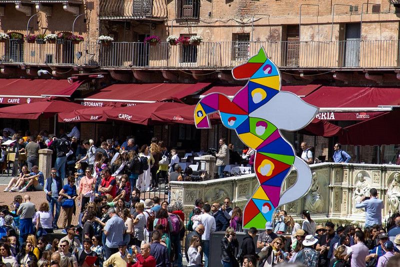
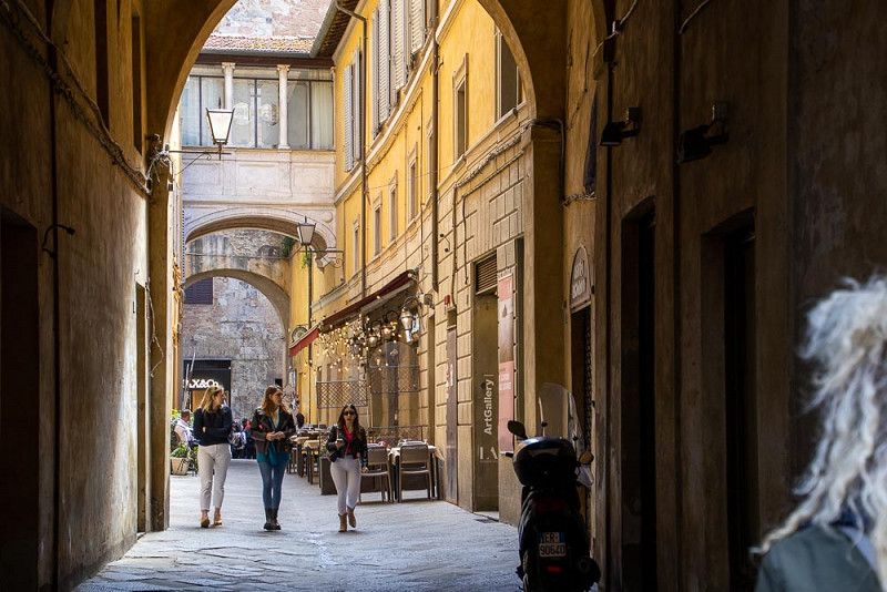
Arriving there, already about to jump into adventure, we have to realize that our privilege of an exclusive, largely undisturbed tour of discovery through the narrow streets of the old town is now lost. Today, when the weather is nice, we share the ambience with a huge number of visitors, the number of which has multiplied compared to other hotspots. We can hardly capture the radiant beauty of the historic buildings through well-designed photos without an extra stepping in and fighting for the privilege of taking a selfie.
At the main square, the Piazza del Campo , we allow ourselves a coffee break and watch the hustle and bustle comfortably while sitting. A horse race is held here once in July and once in August - we would love to be there too, as we saw impressive photos of it on display.
We retreat away from the pulsing flow of people and enjoy small details that cannot be found in any tourist guide.
43° 10' 2" N 11° 28' 1.9" E
43.1672254 11.4671812
• Head east on Via Borgo del Ponte Darbia.
• Turn left toward Via Borgo del Ponte Darbia. Go for 123 m.
• Turn right onto Via Borgo del Ponte Darbia. Go for 116 m.
• Turn right onto Via Romana (SR2). Go for 6.6 km.
• Take the 3rd exit from roundabout onto SR2 toward Firenze-Roma/A1/Arezzo-Perugia/E78/Siena/Grosseto/Arezzo/Firenze. Go for 4.4 km.
• Turn right onto Strada Regionale Cassia (SR2) toward Grosseto/Firenze/Siena/Monteroni d' Arbia Nord. Go for 3.3 km.
• Take the 2nd exit from roundabout onto Strada Regionale Cassia (SR2). Go for 5.3 km.
• Turn left onto Strada Massetana Romana (SP6) toward Porta S. Marco/Porta Tufi/A1. Go for 867 m.
• Take the 2nd exit from roundabout onto Strada Massetana Romana (SP6) toward Porta S.Marco/A1/Centro. Go for 714 m.
• Take the 2nd exit from Strada Massetana Romana roundabout onto Tangenziale Siena Ovest toward Firenze/A1. Go for 62.7 km.
• Keep left onto Superstrada Firenze-Siena (RA3) toward Autostrade/A1/A11/Impruneta/SR2/Tavarnuzze/Galluzzo. Go for 441 m.
• Take the 3rd exit from roundabout onto A1 (Autostrada del Sole) toward Bologna/Roma/Firenze/A11/Pisa Nord/Aeroporto A. Vespucci. Go for 34.1 km.
• Keep right onto A1var toward Bologna/Barberino. Go for 39.1 km.
• Continue on A1 (Autostrada del Sole). Go for 23.9 km.
• Take the exit toward E45/Ancona-Ravenna/Fiera Bologna/Padova/A13/Aeroporto Tangenziale/Bologna Casalecchio/Bologna Centro onto A14 (Autostrada Adriatica). Go for 10.7 km.
• Take the exit toward Padova/Bologna Arcoveggio onto A13 (Autostrada Bologna-Padova). Go for 117 km.
• Take the exit toward Venezia onto A4 (Autostrada della Serenissima). Go for 125 km.
• Take the left exit toward Udine/Tarvisio onto A23 (Autostrada Alpe-Adria). Go for 44.7 km.
• Take the exit toward Osoppo/Gemona. Go for 1.0 km.
• Continue on SP49 toward Osoppo/Gemona/Venzone/Tarcento/Tarvisio. Go for 1.4 km.
• Take left ramp onto Strada Statale Pontebbana (SS13) toward Gemona/Osoppo/Tarvisio. Go for 2.9 km.
• Turn left onto Via Cavazzo (SS512) toward Cavazzo/Trasaghis/Bordano. Go for 1.5 km.
• Take the 3rd exit from roundabout onto SS512. Go for 875 m.
• Pass 2 roundabouts and continue on Via Armando Diaz (SS512). Go for 4.4 km.
• Turn left onto Via 8 Ottobre. Go for 615 m.
• Continue on Piazza 4 Novembre. Go for 283 m.
• Continue on Piazza 1 Maggio. Go for 45 m.
• Continue on Via Tolmezzo. Go for 2.5 km.
• Arrive at Via Tolmezzo.
☍
494,6 km
(4 hrs. 54 min.)
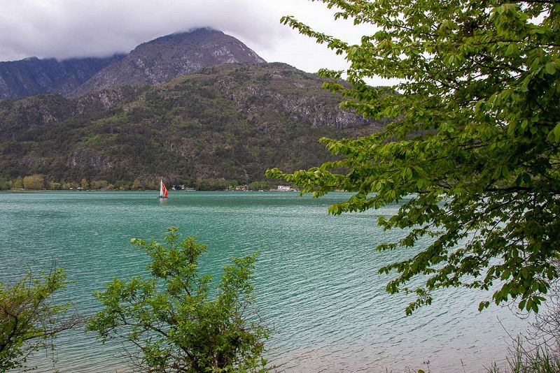
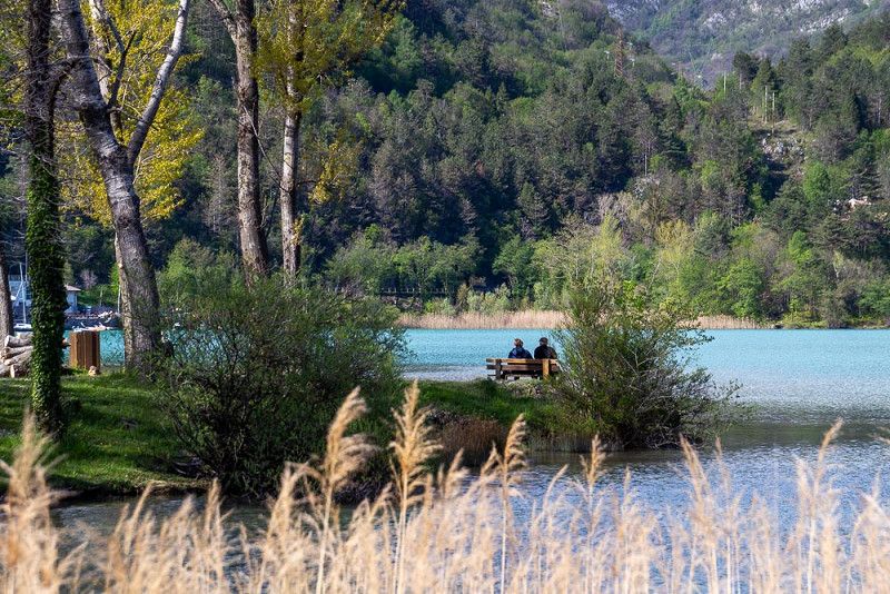
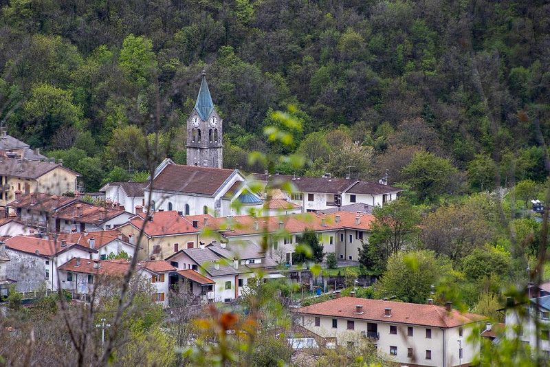
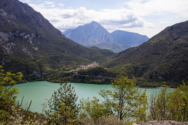
Lago di Cavazzo, Italien
Our heads, now packed with countless pictures and unforgettable impressions, need a break before we go back to work as eager, longingly awaited grandparents.
A quiet lake surrounded by mountains, the Lago di Cavazzo offers us the right environment to reformat our mental storage space. On a few smaller hikes in the spring-green landscape around the lake and in the small town of Alesso , we find enough relaxation and drive back home freshly strengthened, with many souvenirs for young and old in our backpacks and a mountain of dirty laundry.
46° 19' 47.5" N 13° 4' 32.7" E
46.3298546 13.0757536
• Head northeast on Via Tolmezzo. Go for 2.0 km.
• Turn left onto Località Somplago (SS512). Go for 3.4 km.
• Turn right onto Via 4 Novembre. Go for 372 m.
• Turn right onto Piazzale dei Caduti. Go for 1.5 km.
• Take ramp onto SS52 toward Tarvisio/Udine/A28/Udine/SS13. Go for 1.5 km.
• Take ramp toward Udine/A23/Tarvisio. Go for 363 m.
• Take the 4th exit from roundabout onto A23 (Autostrada Alpe-Adria) toward Tarvisio. Go for 61.6 km.
• Continue on A2 (Süd Autobahn). Go for 51.9 km.
• Take the exit toward Wien/Graz/Klagenfurt Nord/Flughafen onto A2 (Süd Autobahn). Go for 207 km.
• Take exit 111 toward Lafnitztal/Oberwart onto Anschlussstelle Lafnitztal Oberwart. Go for 2.1 km.
• Continue on Burgenland Bundesstraße (B50). Go for 5.8 km.
• Take the 3rd exit from roundabout onto Burgenland Bundesstraße (B50) toward Eisenstadt/Szombathely/Oberwart/Bad Tatzmannsdorf. Go for 2.6 km.
• Take the 2nd exit from roundabout onto Grazer Straße (B50) toward Zentrum/Schlösserstraße. Go for 617 m.
• Turn right onto Dornburggasse (L269). Go for 990 m.
• Turn left onto Schulgasse (L269). Go for 574 m.
• Take the 2nd exit from roundabout onto Schulgasse. Go for 230 m.
• Turn right onto Badgasse. Go for 38 m.
• Turn left onto Ganghofergasse. Go for 98 m.
• Arrive at Ganghofergasse. Your destination is on the right.
☍
342,9 km
(3 hrs. 23 min.)
Oberwart, Österreich
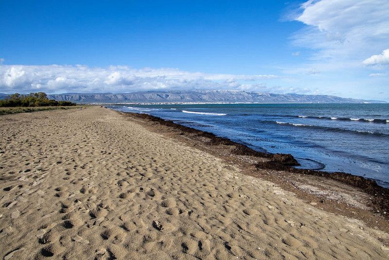
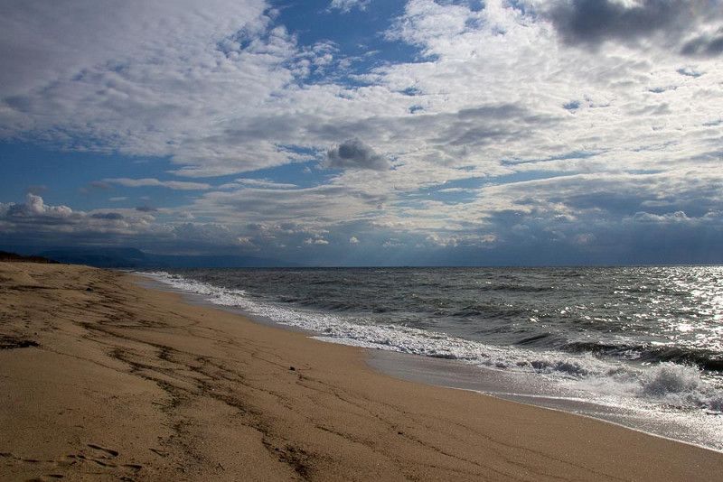
Jupiter, the Roman father of the gods and lord of thunder and lightning, meant well with us and gave us passable travel weather. We have found Italy's beaches, which are occupied by bathers in the summer, still deserted and have surrendered with great enthusiasm to the gusty winds on miles of walks and watched in amazement at the lashing waves as they rushed towards the land.
Italy has offered us a vast array of historic cities laden with man-made structures from all eras. We've consumed a lot of it and still feel like we've missed out.
The Italian food was presented in every restaurant, no matter how small, with exclusive table culture, and we were always enchanted with regional cuisine. It might have sometimes been appropriate to swap our travel clothes for an outfit from a designer boutique. To the chagrin of my husband, I could hardly get enough of the Italian fashion and the design of the leather goods on display.
He preferred to experience nature in the countryside and to relax while hiking - I also love this active side of vacation. And it wasn't hard to find a small lake surrounded by mountains, or alpine meadows in the spring rush.
Italy amazed us!
Grazie e arrivederci Italia!
Oberwart, 7400, Österreich
47° 17' 10.1" N 16° 12' 44.7" E
47.2861513 16.2124214