Zu Hause in Issum
Today, March 12, we started around 9:00 a.m. Toll-free to the first stop.
Kreis Kleve, Nordrhein-Westfalen, Deutschland
51° 32' 5" N 6° 25' 28.2" E
51.5347321 6.4245085
• Head toward Gelderner Straße. Go for 34 m.
• Turn right onto Gelderner Straße. Go for 63 m.
• Turn left onto Rosenstraße. Go for 249 m.
• Turn right onto Neustraße. Go for 236 m.
• Turn right onto Hamsfeld (B58). Go for 783 m.
• Turn left onto L362 toward Kamp-Lintfort/Hoerstgen/Kerken/Sevelen. Go for 58 m.
• Turn right onto Sevelener Straße (L362). Go for 3.9 km.
• Take the 2nd exit from roundabout onto Issumer Straße (L362) toward Kerken. Go for 5.7 km.
• Turn right onto Rheurdter Straße (B510) toward Kerken-Aldekerk. Go for 350 m.
• Turn left onto Umgehungsstraße (B9) toward Krefeld/Moers. Go for 931 m.
• Turn right onto Kempener Landstraße (L362) toward Kempen. Go for 3.0 km.
• Turn left and take ramp onto A40 toward Venlo. Go for 15.2 km.
• Continue on A67 (Europaweg). Go for 5.6 km.
• Take the exit toward Venlo-West/Zuid/Maastricht. Go for 2.8 km.
• Make a U-Turn at Eindhovenseweg. Go for 98 m.
• Take ramp onto A73. Go for 39.6 km.
• Take the exit onto A2. Go for 46.7 km.
• Continue on E25. Go for 8.4 km.
• Take the exit toward Ring/E42 onto E40 (Pont de Liège). Go for 12.9 km.
• Continue on E42 toward Namur/Seraing/A604/Aéroport Liège. Go for 77.6 km.
• Take the exit toward Beaumont/Charleroi/Châtelet onto R3. Go for 11.1 km.
• Take exit 9 toward Bouffioulx/Loverval/Couillet. Go for 262 m.
• Take the 3rd exit from roundabout onto Rue de la Blanche Borne toward Couillet. Go for 241 m.
• Continue on Rue Longue Haie. Go for 753 m.
• Take the 1st exit from roundabout onto Rue de Villers. Go for 492 m.
• Turn left onto Rue de l'Armée Française. Go for 900 m.
• Continue on Rue Joseph Wauters. Go for 130 m.
• Take the 4th exit from roundabout onto Route de Philippeville (E420) toward Philippeville. Go for 1.8 km.
• Pass 3 roundabouts and continue on Route de Philippeville (E420). Go for 49.0 km.
• Continue toward D985. Go for 409 m.
• Continue on D985. Go for 3.5 km.
• Continue on N51. Go for 2.3 km.
• Continue on A304. Go for 29.7 km.
• Continue on A34. Go for 33.2 km.
• Keep left onto N51 toward Reims/Rethel/L'Étoile. Go for 31.6 km.
• Keep left onto A34. Go for 12.5 km.
• Keep left onto Avenue Nicéphore Niépce (N244) toward Paris/Châlons en Ch. Go for 241 m.
• Keep left onto Avenue Nicéphore Niépce (N244) toward A34/E50/E46/Paris/Lyon/Metz/Nancy/Châlons-en-Ch. Go for 102 m.
• Take ramp onto A34 (Autoroute de l'Est). Go for 2.1 km.
• Take the exit toward Lyon/Troyes/Strasbourg/Metz/Nancy/Châlons en Ch. onto A4 (Autoroute de l'Est). Go for 23.6 km.
• Take the exit toward St Gibrien/Châlons en Ch. Rive Gauche/Troyes/Lyon onto A26. Go for 62.5 km.
• Take exit 21 toward Arcis S/ Aube/Brienne le Château/Romilly S/Seine. Go for 1.4 km.
• Take the 3rd exit from roundabout onto D441 toward Torcy-le-Grand/Arcis S/Aube. Go for 3.7 km.
• Continue on Route de Brienne (D441) toward Villette S/A./Méry S/Seine/Romilly S/Seine/Sézanne. Go for 965 m.
• Continue on Route de Paris (D441). Go for 17.9 km.
• Turn left onto Rue du Jeu de Boules. Go for 43 m.
• Turn right onto Rue Chevalot. Go for 159 m.
• Turn left onto Ruelle de Montpellier. Go for 24 m.
• Arrive at Ruelle de Montpellier. Your destination is on the left.
☍
514,7 km
(5 hrs. )
30. Nov. -0001 -
30. Nov. -0001
Méry-sur-Seine
Around 3:20 p.m., we arrived at the car park, formerly the Municipal Camping. It's very quiet, so I highly recommend it. We took a short walk through the small town on the Canal sur Seine and to the Seine. We'll continue tomorrow.
Ruelle Montpellier, Méry-sur-Seine, Aube, Grand Est, Frankreich
48° 30' 29.1" N 3° 53' 29" E
48.5080851 3.8913919
• Head toward Rue Montpellier on Ruelle de Montpellier. Go for 32 m.
• Turn right onto Rue Montpellier. Go for 62 m.
• Turn right onto Rue du Colonel Fossoyeux. Go for 77 m.
• Turn left onto Rue du Général Leclerc (D373). Go for 4.0 km.
• Take the 2nd exit from roundabout onto D7 toward Marigny-le-Châtel/Orvilliers-St-Julien. Go for 4.2 km.
• Continue on Rue de la Libération (D7). Go for 7.3 km.
• Continue on Route d'Orvilliers (D7). Go for 154 m.
• Turn right onto Rue Principale (D442). Go for 335 m.
• Turn left onto Route de Prunay (D33 A). Go for 389 m.
• Continue on D33 A. Go for 883 m.
• Turn left onto D33. Go for 1.2 km.
• Continue on Rue du Moulin (D33). Go for 1.3 km.
• Turn right onto Rue de la Forge (D29). Go for 340 m.
• Continue on Rue de la Craise (D29). Go for 1.3 km.
• Continue on D29. Go for 4.1 km.
• Turn left onto Rue Saint-Martin (D23). Go for 628 m.
• Turn right onto Rue d'Obterre (D154). Go for 480 m.
• Continue on Rue d'Alsace (D154). Go for 4.5 km.
• Continue on Rue d'Alsace (D95). Go for 853 m.
• Turn left onto Rue de la République (D374). Go for 4.0 km.
• Turn right onto D660. Go for 9.1 km.
• Turn right toward A5/E54/E511/Sens/Paris/Orléans/Metz/Nancy/Lyon. Go for 104 m.
• Take the 2nd exit from roundabout toward A5/Troyes/Metz/Nancy/Lyon/Paris/Orléans. Go for 536 m.
• Take left ramp onto A5 toward Orléans/Paris/Sens. Go for 23.7 km.
• Take the exit toward Sens/Provins/Orléans onto A19. Go for 28.5 km.
• Take the exit toward Orléans/Montargis onto A19. Go for 101 km.
• Continue toward Bordeaux/Orléans. Go for 464 m.
• Take the exit onto A10 (L'Aquitaine). Go for 135 km.
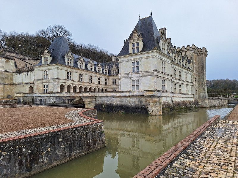
• Take the exit toward Nantes/Angers onto A85. Go for 17.7 km.
• Take exit 8 toward Villandry/Lignières de Touraine. Go for 444 m.
• Turn left onto D7 toward Villandry/Savonnières. Go for 2.6 km.
• Enter the roundabout. Go for 44 m.
• Arrive at your destination on the right.
☍
354,6 km
(3 hrs. 15 min.)
30. Nov. -0001 -
30. Nov. -0001
Aire du Camping-cars Villandry
Arrival in Vallendry around 1:30 p.m. Perfect parking spot for visiting the castle and the beautiful park. Walk to the Cher and Loire rivers.
Rue Principale, 37510, Villandry, Frankreich
47° 20' 21.4" N 0° 30' 26.6" E
47.3392910 0.5074000
• Follow the roundabout. Go for 10 m.
• Take the 2nd exit from roundabout onto Rue Principale (D7). Go for 2.8 km.
• Turn right and take ramp onto A85 toward Tours. Go for 16.4 km.
• Take the exit toward Bordeaux onto A10 (L'Aquitaine). Go for 163 km.
• Take exit 33 toward E601/La Rochelle/Rochefort/Surgères/Niort-Sud onto N248. Go for 2.9 km.
• Continue on N248. Go for 7.8 km.
• Take ramp onto N11. Go for 10.6 km.
• Take ramp onto D911 toward Rochefort/Surgères. Go for 2.6 km.
• Take the 3rd exit from roundabout onto D911 toward Rochefort/Surgères/St Georges du Bois. Go for 7.9 km.
• Continue on Rue Olivier Brillouet (D911) toward Centre Ville. Go for 361 m.
• Continue on Rue Gambetta (D911). Go for 411 m.
• Continue on Rue Martyrs de la Résistance (D911). Go for 117 m.
• Continue on Place du Général Leclerc (D911). Go for 1.4 km.
• Pass 3 roundabouts and continue on Avenue du Pont Neuf (D911). Go for 22.4 km.
• Take the 2nd exit from roundabout onto Avenue de la Libération (D739). Go for 1.5 km.
• Take the 3rd exit from roundabout onto Rue Michel Bégon. Go for 345 m.
• Take the 1st exit from roundabout onto Place Gaspard Cochon-Dupuy. Go for 15 m.
• Pass 3 roundabouts and continue on Rue Pierre Toufaire. Go for 988 m.
• Turn right onto Rue Vaudreuil. Go for 62 m.
• Take the 2nd exit from Rue Jean Jaurès roundabout onto Rue Jean Jaurès. Go for 178 m.
• Take the 2nd exit from Rond-Point Vauban roundabout onto Avenue du 11 Novembre 1918. Go for 74 m.
• Keep right onto Avenue du 11 Novembre 1918. Go for 317 m.
• Take the 3rd exit from roundabout onto Rue de l'Avant-Garde. Go for 430 m.
• Take the 2nd exit from roundabout. Go for 100 m.
• Arrive at your destination on the left.
☍
242,4 km
(2 hrs. 21 min.)
14. Mar. 2025 -
15. Mar. 2025
Camping Car Parking, Avenue de la Fosse aux Mâts, 17300 Rochefort, Frankreich
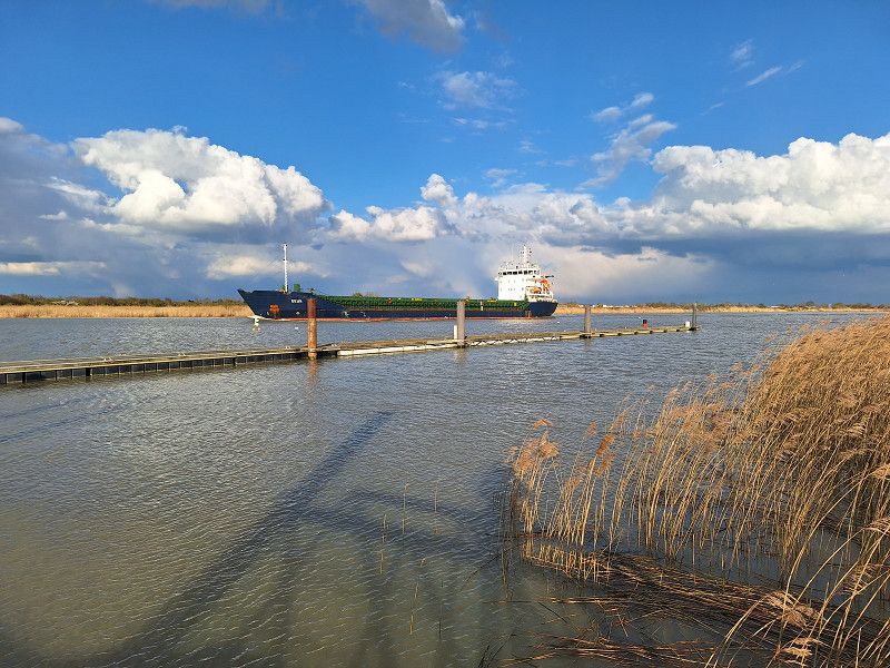
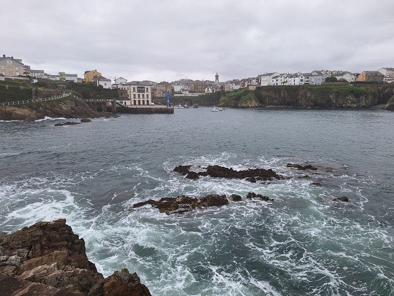
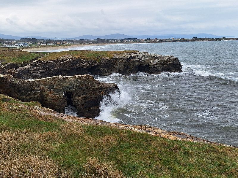
We arrived at the campsite around 1:00 p.m. The site was very quiet on the Charente River. Large ships sailed by, see photo. Then we took a short bike ride in and around Rochefort. It was a beautiful place, a former French naval base during Napoleon's time. The cable-stayed ferry across the Charente River is worth seeing.
Avenue de la Fosse aux Mâts, 17300 Rochefort, Frankreich
45° 55' 40.1" N 0° 57' 17.3" W
45.9278111 -0.9548027
• Head southeast. Go for 83 m.
• Take the 1st exit from roundabout onto Avenue de la Fosse aux Mâts. Go for 522 m.
• Turn sharp right onto Avenue du 11 Novembre 1918. Go for 62 m.
• Take the 1st exit from Rond-Point Vauban roundabout onto Rue Jean Jaurès. Go for 180 m.
• Take the 1st exit from Rue Jean Jaurès roundabout onto Rue Vaudreuil. Go for 74 m.
• Turn left onto Rue Pierre Toufaire. Go for 331 m.
• Pass 2 roundabouts and continue on Place Gaspard Cochon-Dupuy. Go for 648 m.
• Take the 1st exit from roundabout onto Place Gaspard Cochon-Dupuy. Go for 12 m.
• Take the 2nd exit from roundabout onto Rue Michel Bégon. Go for 288 m.
• Take the 1st exit from roundabout onto Avenue Camille Pelletan (D911). Go for 448 m.
• Turn left onto Avenue Victor-Louis Bachelar (D911). Go for 940 m.
• Take the 3rd exit from roundabout onto Avenue d'Aigrefeuille (D5). Go for 893 m.
• Take the 2nd exit from Rond-Point Bernadotte roundabout onto Avenue d'Aigrefeuille (D5). Go for 288 m.
• Take the 3rd exit from Rond-Point des Surs roundabout onto A837 (Autoroute des Oiseaux) toward A10 (Bordeaux)/St Jean d'Angély/Saintes/Bordeaux. Go for 34.4 km.
• Continue on A10 (L'Aquitaine). Go for 107 km.
• Take exit 1 toward Toulouse/Bayonne/Bassin d'Arcachon/Bordeaux/Périgueux onto N230 (Rocade de Bordeaux). Go for 19.8 km.
• Take exit 15 toward Saint Sébastien/Bayonne/Mont de Marsan/Bassin d'Arcachon onto A63. Go for 118 km.
• Take exit 12 toward Léon/Vielle-St-Girons/Moliets-et-Maâ. Go for 765 m.
• Take the 3rd exit from roundabout onto Route de Dax (D947) toward Castets/Léon/Vielle-St-Girons/Moliets-et-Maâ/Centre Ville. Go for 687 m.
• Take the 2nd exit from roundabout onto Rue de Juston (D947). Go for 558 m.
• Take the 3rd exit from roundabout onto Rue Canté Cigale (D10 E). Go for 711 m.
• Continue on Route de Chanchon (D10 E). Go for 1.5 km.
• Turn right onto Route d'Azur (D378). Go for 4.6 km.
• Continue on D378. Go for 823 m.
• Continue on Lieu-dit Clariotte (D378). Go for 77 m.
• Continue on D378. Go for 2.6 km.
• Continue on Route de Magescq (D378). Go for 808 m.
• Continue on D378. Go for 1.1 km.
• Continue on Route d'Azur (D378). Go for 945 m.
• Continue on Route de Léon (D378). Go for 1.6 km.
• Turn left onto Rue de Labèque (D378). Go for 12 m.
• Continue on Route de Moliets (D378). Go for 649 m.
• Continue on Rue Jules Ferry (D378). Go for 230 m.
• Take the 1st exit from roundabout onto Rue de la Fontaine (D50). Go for 367 m.
• Continue on D50. Go for 767 m.
• Continue on Route de Messanges (D50). Go for 1.4 km.
• Continue on D50. Go for 3.3 km.
• Continue on Avenue de la Gemme (D50). Go for 252 m.
• Continue on Lieu-dit Pierroulet (D50). Go for 416 m.
• Continue on Avenue de la Gemme (D50). Go for 178 m.
• Take the 2nd exit from roundabout onto Avenue de la Gemme (D50). Go for 427 m.
• Take the 2nd exit from roundabout onto Avenue de l'Océan (D82). Go for 181 m.
• Turn slightly left onto Avenue de l'Océan (D82). Go for 1.8 km.
• Turn right. Go for 16 m.
• Arrive at your destination.
☍
310,3 km
(2 hrs. 56 min.)
15. Mar. 2025 -
16. Mar. 2025
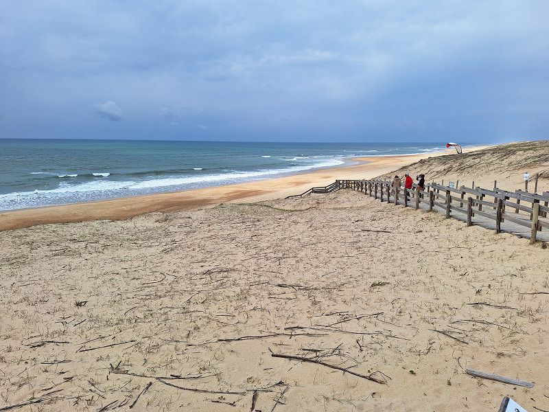
Parking Plage Principale
Pitch at the car park. Directly behind the dunes. Superfine sandy beach. Beautiful bike rides along former railway lines along the coast are possible.
Avenue de la Plage, 40660, Messanges, Frankreich
43° 48' 57" N 1° 24' 3" W
43.8158333 -1.4008333
• Head toward Avenue de l'Océan. Go for 16 m.
• Turn left onto Avenue de l'Océan (D82). Go for 1.9 km.
• Take the 2nd exit from roundabout onto Avenue de la Gemme (D50). Go for 439 m.
• Take the 2nd exit from roundabout onto Avenue de la Gemme (D50). Go for 204 m.
• Continue on Lieu-dit Quartier de la Gare (D50). Go for 416 m.
• Continue on Avenue de la Gemme (D50). Go for 252 m.
• Continue on D50. Go for 3.3 km.
• Continue on Route d'Azur (D50). Go for 1.4 km.
• Continue on D50. Go for 767 m.
• Continue on Rue de la Fontaine (D50). Go for 357 m.
• Take the 1st exit from roundabout onto Avenue Émile Sescousse (D50). Go for 78 m.
• Take the 2nd exit from roundabout onto Avenue Émile Sescousse (D50). Go for 842 m.
• Turn left onto Rue Henri Goalard (D150). Go for 2.7 km.
• Continue on Lieu-dit Lessègues (D150). Go for 85 m.
• Continue on D150. Go for 841 m.
• Continue on Lieu-dit Ireye (D150). Go for 149 m.
• Continue on Route d'Azur (D150). Go for 2.4 km.
• Turn right onto Avenue du Marensin (D16). Go for 819 m.
• Continue on Rue de la République (D16). Go for 64 m.
• Continue on Rue Robert Dubaa (D16). Go for 184 m.
• Turn left onto Avenue de la Chalosse (D16). Go for 255 m.
• Take the 1st exit from roundabout onto A63 toward Bayonne/San Sebastian/St-Geours de Ma. Go for 75.5 km.
• Continue on AP-8 (Autopista del Cantábrico). Go for 12.2 km.
• Continue on GI-20 toward Errenteria/Beraun/Pasaia/Donostia/S. Sebastián. Go for 10.9 km.
• Take exit 10 toward Donostia/Ondarreta onto Camino de Zubiberri. Go for 1.6 km.
• Keep left onto Avenida de Tolosa. Go for 665 m.
• Turn right toward El Antiguo/Ondarreta/Unibertsitatea. Go for 63 m.
• Turn right onto Avenida de Tolosa toward El Antiguo/Ondarreta/Unibertsitatea. Go for 540 m.
• Take the 4th exit from Plaza de Europa roundabout onto Paseo de Berio toward Berio/Unibertsitatea. Go for 242 m.
• Take the 1st exit from roundabout onto Paseo de Berio. Go for 165 m.
• Turn right onto Paseo de Berio. Go for 197 m.
• Arrive at your destination on the right.
☍
119,3 km
(1 hrs. 17 min.)
16. Mar. 2025 -
17. Mar. 2025
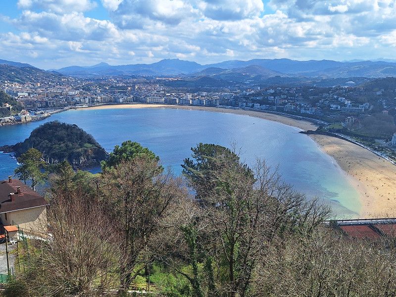
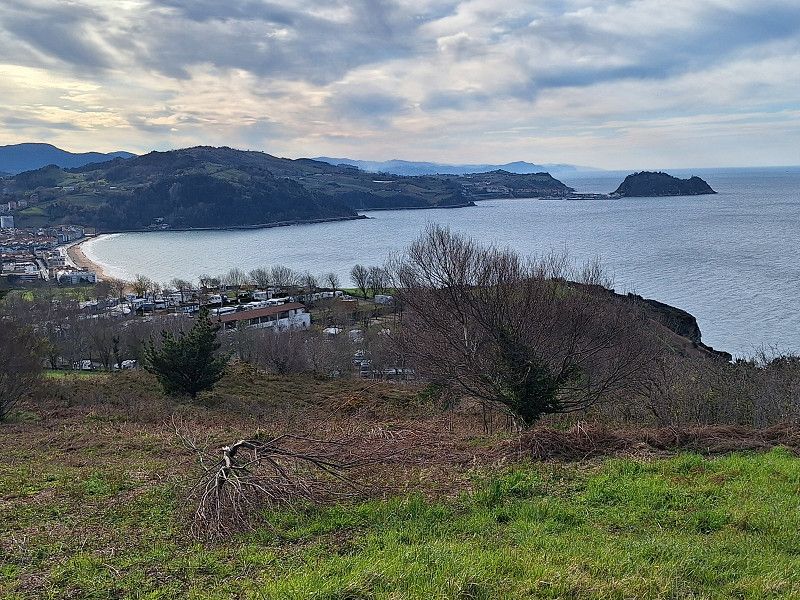
Area Autocaravanas Donosti, Amezketa Bidea, 905, 20018 Donostia, Gipuzkoa, Spain
Bicycle tour in Donostia / San Sebastian, visit to the old town, possibly a cog railway
Amezketa Bidea, 905, 20018 Donostia, Gipuzkoa, Spanien
43° 18' 29" N 2° 0' 52.2" W
43.3080600 -2.0144900
• Head toward Berio pasealekua. Go for 46 m.
• Turn left onto Paseo de Berio. Go for 73 m.
• Turn left onto Paseo de Berio. Go for 146 m.
• Take the 2nd exit from roundabout onto Paseo de Berio. Go for 197 m.
• Take the 2nd exit from Plaza de Europa roundabout onto Avenida de Tolosa toward A-8/N-634/A-15/N-1. Go for 567 m.
• Turn right onto Avenida de Tolosa toward Vitoria/N-1/Gasteiz/N-634/Bilbao/A-8/Pamplona/A-15/Iruña. Go for 91 m.
• Take ramp onto Avenida Zarautz. Go for 529 m.
• Take ramp onto GI-20. Go for 3.6 km.
• Continue on AP-1/AP-8 (Autopista del Cantábrico). Go for 10.0 km.
• Take exit 38 toward N-634/Zarautz/Getaria. Go for 578 m.
• Take the 2nd exit from roundabout onto Calle Irita. Go for 119 m.
• Take the 2nd exit from roundabout onto Camino Mendibeltz. Go for 162 m.
• Turn left onto Camino Sorginmuno. Go for 18 m.
• Turn right toward Camino Talaimendi. Go for 203 m.
• Turn slightly left onto Camino Talaimendi. Go for 87 m.
• Turn right toward Camino Talaimendi. Go for 373 m.
• Continue on Camino Talaimendi. Go for 212 m.
• Turn slightly left onto Camino Talaimendi. Go for 262 m.
• Turn right toward Camino Talaimendi. Go for 77 m.
• Turn slightly left onto Camino Talaimendi. Go for 10 m.
• Turn left onto Laurgain kalea. Go for 16 m.
• Continue toward Camino Talaimendi. Go for 57 m.
• Turn left onto Camino Talaimendi. Go for 5 m.
• Turn right. Go for 27 m.
• Turn left. Go for 28 m.
• Arrive at your destination on the left.
☍
17,5 km
( 17 min.)
17. Mar. 2025 -
18. Mar. 2025
Camping Gran Camping Zarautz
Today we're at a campsite. It's located with a fantastic view over Zeautz to Getaria. We cycled along the coastal road to Getaria, to the lighthouse, and then on to Santiago and back.
Monte Talai-mendi Zarautz, 20800, Zarautz, Spanien
43° 17' 26" N 2° 8' 48" W
43.2905600 -2.1466700
• Head east. Go for 28 m.
• Turn right toward Camino Talaimendi. Go for 27 m.
• Turn left onto Camino Talaimendi. Go for 5 m.
• Turn right toward Laurgain kalea. Go for 57 m.
• Continue on Laurgain kalea. Go for 16 m.
• Turn right onto Camino Talaimendi. Go for 10 m.
• Turn slightly right toward Camino Talaimendi. Go for 77 m.
• Turn left onto Camino Talaimendi. Go for 262 m.
• Turn slightly right onto Camino Talaimendi. Go for 212 m.
• Turn left toward Camino Talaimendi. Go for 373 m.
• Turn left onto Camino Talaimendi. Go for 87 m.
• Turn slightly right toward Camino Sorginmuno. Go for 203 m.
• Turn left onto Camino Sorginmuno. Go for 18 m.
• Turn right onto Camino Mendibeltz. Go for 112 m.
• Take the 2nd exit from roundabout onto Calle Irita toward Bilbao/A-8/Donostia/S. Sebastián. Go for 133 m.
• Take the 2nd exit from roundabout toward Donostia/San Sebastián/Bilbo/Vitoria/Gasteiz. Go for 75 m.
• Take ramp onto AP-1/AP-8 (Autopista del Cantábrico) toward Bilbo/Bilbao/Vitoria-Gasteiz. Go for 31.4 km.
• Continue on AP-8 (Autopista del Cantábrico) toward Eibar/Bilbao. Go for 34.2 km.
• Take exit 103 toward N-637/Aireportua/Centro Ciudad Bilbao/Barakaldo/Getxo onto BI-30. Go for 9.9 km.
• Take exit 18 toward Aireportua/Mungia onto BI-631. Go for 11.2 km.
• Take the 3rd exit from roundabout onto Calle Bermeo Bidea (BI-631) toward Bakio/Bermeo. Go for 2.7 km.
• Take the 1st exit from roundabout onto Calle Bermeo Bidea (BI-631). Go for 1.4 km.
• Take the 2nd exit from roundabout onto Camino Bakio (BI-2101) toward Bakio. Go for 1.8 km.
• Continue on BI-2101. Go for 196 m.
• Continue on Elorriagakoetxebarria (BI-2101). Go for 81 m.
• Continue on BI-2101. Go for 2.4 km.
• Continue on Gaztañazarreta (BI-2101). Go for 179 m.
• Continue on BI-2101. Go for 341 m.
• Continue on Barrio Arza-Alde (BI-2101). Go for 195 m.
• Continue on Barrio Artzalde (BI-2101). Go for 227 m.
• Continue on Barrio Zubiaurrealde (BI-2101). Go for 9 m.
• Continue on Calle Basigoko Bide Nagusia (BI-2101). Go for 882 m.
• Take the 2nd exit from roundabout onto Calle Basigoko Bide Nagusia (BI-2101). Go for 583 m.
• Take the 1st exit from roundabout onto Calle San Pelaiako Bidenagusia (BI-3101). Go for 1.2 km.
• Take the 2nd exit from roundabout onto Calle San Pelaioko Bide Nagusia (BI-3101). Go for 197 m.
• Continue on Barrio Gibelorratzagako San Pelaio (BI-3101). Go for 2.0 km.
• Continue on BI-3101. Go for 252 m.
• Turn left onto Barrio Gibelorratzagako San Pelaio. Go for 1.1 km.
• Turn left onto Barrio Gibelorratzagako San Pelaio. Go for 203 m.
• Turn left onto Carretera Pelaio Deuna. Go for 561 m.
• Continue on Carretera Pelaio Deuna. Go for 573 m.
• Continue on Barrio Gibelorratzagako San Pelaio. Go for 134 m.
• Arrive at Barrio Gibelorratzagako San Pelaio.
☍
105,6 km
(1 hrs. 19 min.)
18. Mar. 2025 -
18. Mar. 2025
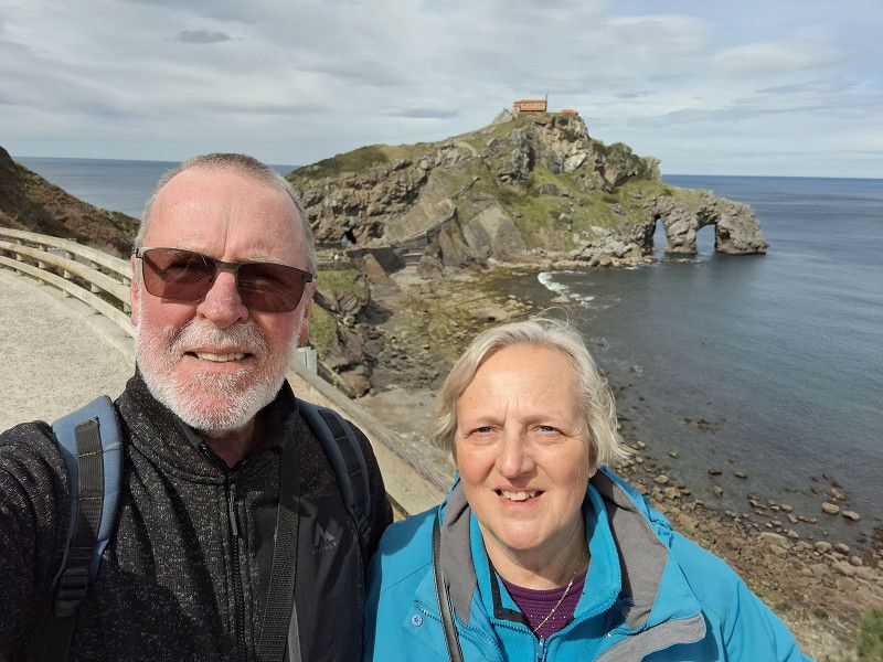
Gaztelugatxeko Doniene, Bizkaia, Spanien
Hike from the hiking car park to Gaztelugatke, a small church on an island accessible via a footpath from the mainland, filming location of Game of Thrones
43° 26' 49.6" N 2° 47' 7.1" W
43.4471185 -2.7853101
• Head southeast on Barrio Gibelorratzagako San Pelaio. Go for 134 m.
• Continue on Carretera Pelaio Deuna. Go for 1.1 km.
• Turn right onto Barrio Gibelorratzagako San Pelaio. Go for 203 m.
• Turn right onto Barrio Gibelorratzagako San Pelaio. Go for 1.1 km.
• Turn right onto BI-3101. Go for 252 m.
• Continue on Barrio Gibelorratzagako San Pelaio (BI-3101). Go for 2.0 km.
• Continue on Calle San Pelaioko Bide Nagusia (BI-3101). Go for 169 m.
• Take the 1st exit from roundabout onto Calle San Pelaiako Bidenagusia (BI-3101). Go for 1.2 km.
• Take the 2nd exit from roundabout onto Calle Basigoko Bide Nagusia (BI-2101). Go for 590 m.
• Take the 2nd exit from roundabout onto Calle Basigoko Bide Nagusia (BI-2101). Go for 904 m.
• Continue on Barrio Zubiaurrealde (BI-2101). Go for 236 m.
• Continue on Barrio Arza-Alde (BI-2101). Go for 195 m.
• Continue on BI-2101. Go for 341 m.
• Continue on Gaztañazarreta (BI-2101). Go for 179 m.
• Continue on BI-2101. Go for 2.4 km.
• Continue on Elorriagakoetxebarria (BI-2101). Go for 81 m.
• Continue on BI-2101. Go for 196 m.
• Continue on Camino Bakio (BI-2101). Go for 1.7 km.
• Take the 1st exit from roundabout onto Barrio Emerando (BI-631). Go for 1.4 km.
• Take the 2nd exit from roundabout onto Calle Bermeo Bidea (BI-631). Go for 2.6 km.
• Take the 1st exit from roundabout onto BI-631. Go for 10.4 km.
• Take exit 9 toward N-637/E-70/A-8/Bilbo Hiri-Erdialdea/Centro Ciudad Bilbao/Vitoria-Gasteiz/Santander onto BI-30. Go for 10.4 km.
• Take the exit toward Bilbao/Vitoria/Gasteiz/Donostia/S. Sebastián onto A-8 (Autovía del Cantábrico). Go for 2.4 km.
• Take exit 119 toward Balmaseda/E-70/AP-8 onto BI-636 (Carretera del Corredor del Cadagua). Go for 579 m.
• Take exit 5 toward Zorrozgoiti/Altamira onto BI-3736 (Carretera de Basurto a Castrexana). Go for 1.9 km.
• Turn right onto Carretera Basurtu-Kastrexana. Go for 247 m.
• Turn right onto Camino Kobetabidea. Go for 320 m.
• Turn left onto Monte Kobeta. Go for 11 m.
• Turn left onto Monte Kobeta. Go for 248 m.
• Arrive at Monte Kobeta. Your destination is on the right.
☍
43,6 km
( 44 min.)
18. Mar. 2025 -
20. Mar. 2025
aire camping-car bilbao, Kobeta, 48002 Bilbo, Bizkaia, Spanien
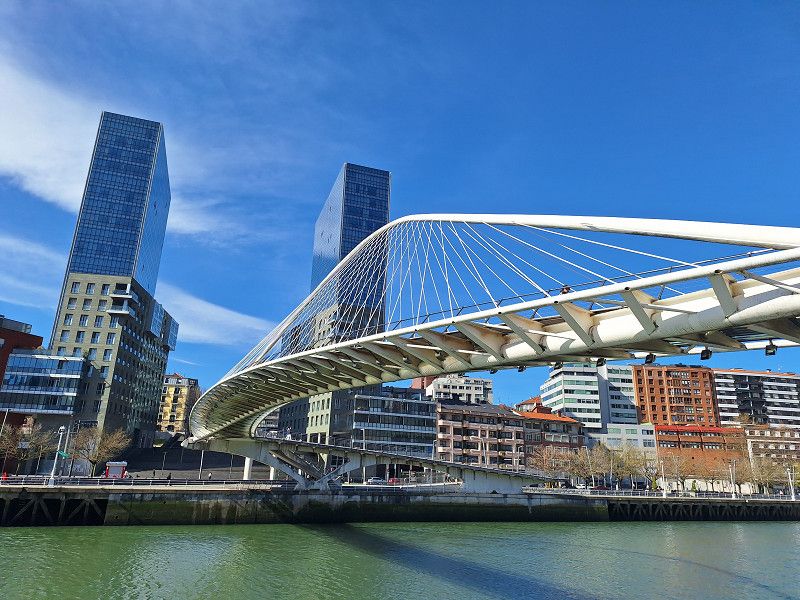
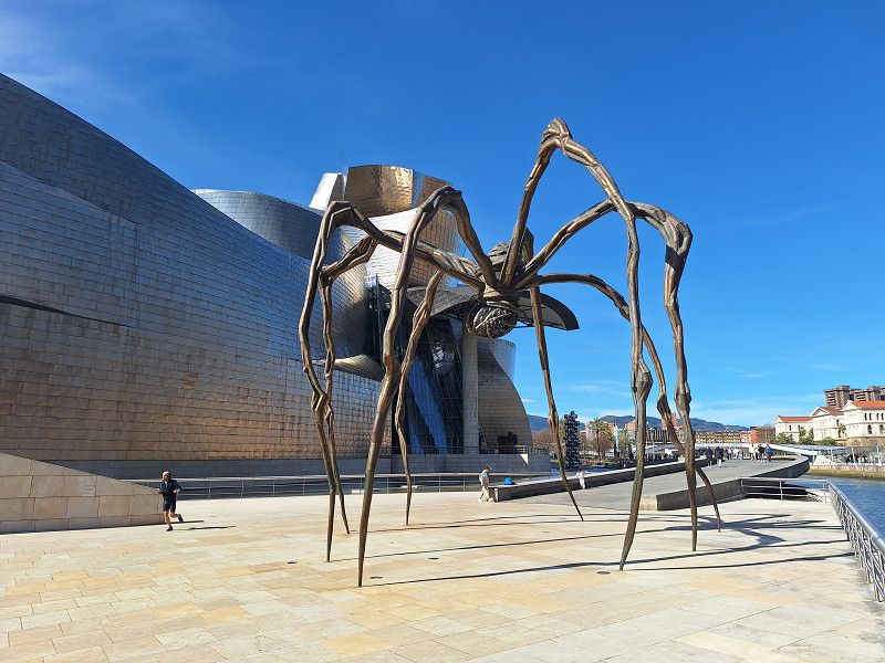
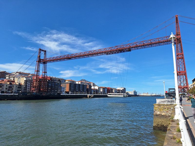
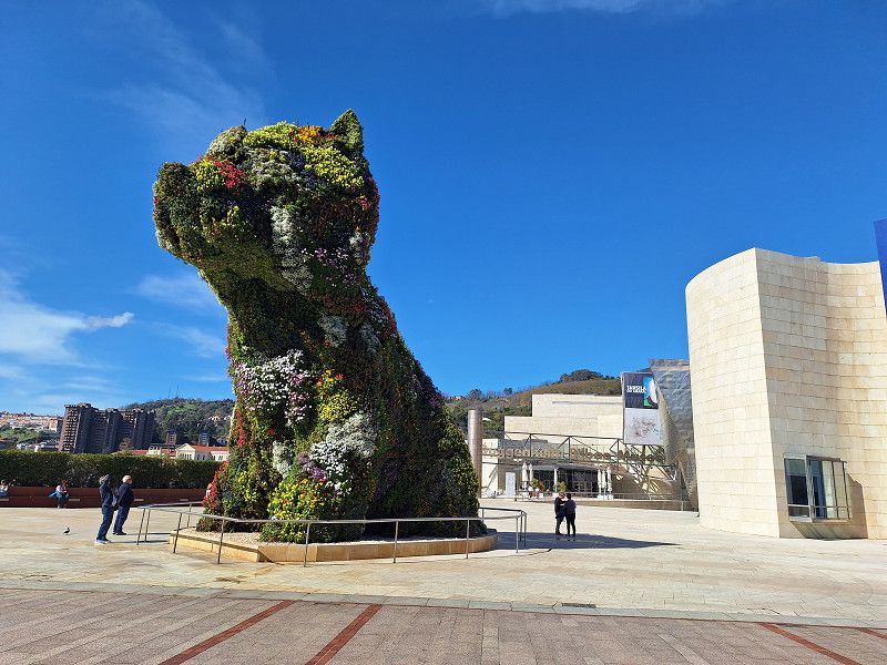
Parking high above the city with a fantastic panoramic view. 75 spaces with everything you need. Access to the city is possible by bus or bike. Bike tour through Bilbao, the old town (Casco Viejo), the Guggenheim Museum, and the transporter bridge in Gatzo.
Kobeta, 48002 Bilbo, Bizkaia, Spanien
43° 15' 35.2" N 2° 57' 49" W
43.2597673 -2.9636240
• Head southeast on Monte Kobeta. Go for 18 m.
• Turn right onto Monte Kobeta. Go for 35 m.
• Turn right. Go for 4 m.
• Turn right toward Monte Kobeta. Go for 24 m.
• Continue on Monte Kobeta. Go for 13 m.
• Turn left onto Monte Kobeta. Go for 266 m.
• Turn right onto Monte Kobeta. Go for 11 m.
• Turn right onto Camino Kobetabidea. Go for 320 m.
• Turn left onto Carretera Basurtu-Kastrexana. Go for 247 m.
• Turn right onto Carretera de Basurto a Castrexana (BI-3736). Go for 72 m.
• Take the 3rd exit from roundabout onto Carretera de Basurto a Castrexana (BI-3736). Go for 1.6 km.
• Take ramp onto BI-636 (Carretera del Corredor del Cadagua) toward Bilbo/Bilbao/Santander. Go for 467 m.
• Take the exit toward Aireportua/Santander onto A-8 (Autovía del Cantábrico). Go for 80.1 km.
• Take exit 199 toward Torrelavega/Oviedo onto A-8 (Autovía del Cantábrico). Go for 35.3 km.
• Take exit 234 toward N-634/Puente San Miguel/Santillana del Mar. Go for 284 m.
• Take the 1st exit from roundabout toward N-634. Go for 173 m.
• Pass 2 roundabouts. Go for 802 m.
• Take the 2nd exit from roundabout onto CA-136. Go for 1.4 km.
• Take the 2nd exit from roundabout onto CA-133 toward Santillana del Mar/Suances. Go for 804 m.
• Continue on Avenida del Zoo (CA-133). Go for 451 m.
• Take the 2nd exit from roundabout onto CA-133 toward Santillana del Mar. Go for 265 m.
• Continue on Avenida del Zoo (CA-133). Go for 546 m.
• Continue toward CA-133. Go for 57 m.
• Continue on Avenida Antonio Sandi (CA-133). Go for 311 m.
• Continue on Calle Jesús Tagle (CA-133). Go for 22 m.
• Continue on Avenida Sánchez Tagle (CA-133). Go for 89 m.
• Turn right onto Avenida Dorat (CA-131). Go for 97 m.
• Turn left onto Calle Jesús Otero. Go for 47 m.
• Turn right onto Calle Jesús Otero. Go for 40 m.
• Turn left. Go for 140 m.
• Turn right toward Calle Jesús Otero. Go for 76 m.
• Turn right onto Calle Jesús Otero. Go for 110 m.
• Turn right onto Calle Río. Go for 82 m.
• Continue on Plaza de las Arenas. Go for 38 m.
• Turn slightly right onto Plaza de las Arenas. Go for 20 m.
• Continue on Calle Río. Go for 33 m.
• Arrive at Calle Río.
☍
124,3 km
(1 hrs. 18 min.)
20. Mar. 2025 -
21. Mar. 2025
Santillana del Mar
Beautifully restored old town. With a great RV parking space. A short tour of the town, followed by a spot to chill.
Kantabrien, Spanien
43° 23' 32.3" N 4° 6' 18.2" W
43.3923116 -4.1050432
• Head toward Plaza de las Arenas on Calle Río. Go for 53 m.
• Turn slightly left onto Plaza de las Arenas. Go for 38 m.
• Continue on Calle Río. Go for 82 m.
• Turn left onto Calle Jesús Otero. Go for 110 m.
• Turn left toward Calle Jesús Otero. Go for 76 m.
• Turn right onto Calle Jesús Otero. Go for 8 m.
• Turn left toward Calle Jesús Otero. Go for 135 m.
• Turn right onto Calle Jesús Otero. Go for 40 m.
• Turn left onto Calle Jesús Otero. Go for 47 m.
• Turn right onto Avenida Dorat (CA-131). Go for 97 m.
• Turn left onto Avenida Sánchez Tagle (CA-133). Go for 89 m.
• Continue on Calle Jesús Tagle (CA-133). Go for 22 m.
• Continue on Avenida Antonio Sandi (CA-133). Go for 368 m.
• Continue on Avenida del Zoo (CA-133). Go for 546 m.
• Continue on CA-133. Go for 173 m.
• Take the 1st exit from roundabout onto Avenida del Zoo (CA-133). Go for 492 m.
• Continue on CA-133. Go for 731 m.
• Take the 1st exit from roundabout onto CA-136. Go for 1.4 km.
• Take the 2nd exit from roundabout toward Santander/Oviedo. Go for 281 m.
• Keep left. Go for 165 m.
• Take the 2nd exit from roundabout toward Santander/E-70/Oviedo/A-8. Go for 286 m.
• Continue on Barrio La Veguilla. Go for 49 m.
• Take the 3rd exit from roundabout. Go for 203 m.
• Take the 1st exit from roundabout onto A-8 (Autovía del Cantábrico) toward Oviedo. Go for 59.6 km.
• Take exit 294 toward Parres/La Pereda/Llanes/AS-379. Go for 320 m.
• Take the 1st exit from roundabout onto AS-379 toward Llanes. Go for 793 m.
• Continue on La Portilla (AS-379). Go for 249 m.
• Take the 3rd exit from roundabout onto Carretera Llanes. Go for 225 m.
• Take the 2nd exit from roundabout onto Carretera Llanes. Go for 178 m.
• Continue toward Calle Pidal. Go for 24 m.
• Take the 1st exit from roundabout onto Calle Pidal. Go for 204 m.
• Turn slightly left onto Calle de las Barqueras. Go for 323 m.
• Continue on Calle Nemesio Sobrino. Go for 123 m.
• Continue on Calle Egidio Gavito. Go for 137 m.
• Turn left onto Llanes. Go for 60 m.
• Turn right onto Calle Román Romano. Go for 22 m.
• Arrive at Calle Román Romano. Your destination is on the left.
☍
67,7 km
( 43 min.)
21. Mar. 2025 -
22. Mar. 2025
Llanes
Román Romano, Llanes, Asturien, Spanien
43° 25' 15.3" N 4° 45' 32.8" W
43.4209241 -4.7591087
• Head toward Llanes on Calle Román Romano. Go for 196 m.
• Turn slightly right onto Calle Hermanas Fcnas. del Hospital. Go for 593 m.
• Take the 3rd exit from roundabout onto AS-379. Go for 516 m.
• Take the 1st exit from roundabout onto La Portilla (AS-379). Go for 272 m.
• Continue on AS-379. Go for 767 m.
• Take the 1st exit from roundabout onto A-8 (Autovía del Cantábrico) toward Ribadesella/Oviedo. Go for 11.4 km.
• Take exit 306 toward Naves/Villahormes/Hontoria. Go for 340 m.
• Turn right. Go for 101 m.
• Turn left. Go for 103 m.
• Turn slightly right. Go for 189 m.
• Turn slightly right. Go for 96 m.
• Arrive at your destination on the left.
☍
14,6 km
( 12 min.)
22. Mar. 2025 -
22. Mar. 2025
Llanes
Autovía del Cantábrico, Llanes, Asturien, Spanien
43° 26' 51.5" N 4° 53' 10.8" W
43.4476377 -4.8863368
• Head southwest. Go for 388 m.
• Turn right toward Autovía del Cantábrico/A-8. Go for 101 m.
• Take ramp onto A-8 (Autovía del Cantábrico). Go for 12.8 km.
• Take exit 319 toward Ribadesella/N-632/Arriondas/N-634/Cangas de Onís/Covadonga/Parque Nacional de los Picos de Europa. Go for 1.4 km.
• Take the 2nd exit from roundabout onto N-632 toward Ribadesella. Go for 2.8 km.
• Take the 3rd exit from roundabout onto N-632. Go for 2.7 km.
• Take the 1st exit from roundabout onto Avenida Los Porqueros. Go for 522 m.
• Take the 3rd exit from roundabout onto San Pedro. Go for 92 m.
• Turn left. Go for 17 m.
• Arrive at your destination on the right.
☍
20,8 km
( 17 min.)
22. Mar. 2025 -
23. Mar. 2025
Camping Playa Sauces
SAN PEDRO ROAD S/N, 33560, Ribadesella, Spanien
43° 28' 4.1" N 5° 5' 18.2" W
43.4678000 -5.0884000
• Head toward San Pedro. Go for 17 m.
• Turn right onto San Pedro. Go for 15 m.
• Take the 1st exit from roundabout onto Avenida Los Porqueros. Go for 536 m.
• Take the 2nd exit from roundabout onto N-632. Go for 2.3 km.
• Turn right onto Avenida de la Cueva de Tito Bustillo (RS-2). Go for 511 m.
• Continue on RS-2. Go for 1.2 km.
• Turn slightly right. Go for 1.1 km.
• Turn right. Go for 905 m.
• Turn right. Go for 1.1 km.
• Turn left. Go for 1.2 km.
• Turn right. Go for 597 m.
• Arrive at your destination on the left.
☍
9,4 km
( 18 min.)
23. Mar. 2025 -
23. Mar. 2025
Ribeseya
Asturien, Spanien
43° 25' 54.4" N 5° 4' 25.1" W
43.4317904 -5.0736526
• Head south.
• Turn right. Go for 58 m.
• Turn right. Go for 42 m.
• Turn left. Go for 569 m.
• Turn left. Go for 1.2 km.
• Turn right. Go for 1.1 km.
• Turn left. Go for 905 m.
• Turn left toward RS-2. Go for 510 m.
• Turn left onto RS-2. Go for 769 m.
• Continue on San Miguel de Ucio (RS-2). Go for 148 m.
• Continue on RS-2. Go for 1.1 km.
• Turn left onto AS-341. Go for 1.8 km.
• Turn right. Go for 226 m.
• Turn slightly right. Go for 678 m.
• Take the 2nd exit from roundabout. Go for 167 m.
• Take the 2nd exit from roundabout onto A-8 (Autovía del Cantábrico) toward Gijón/Oviedo. Go for 34.4 km.
• Continue on A-64 (Viaducto de Grases) toward Pola de Siero/Oviedo/León. Go for 31.9 km.
• Take the left exit toward A-66a/Oviedo/Centro Ciudad/Hospital/La Corredoria. Go for 3.3 km.
• Take the 3rd exit from roundabout onto Calle Aguamiera. Go for 422 m.
• Take the 2nd exit from roundabout onto Calle Aguamiera. Go for 187 m.
• Turn right onto Calle Daniel Moyano. Go for 138 m.
• Take the 1st exit from roundabout. Go for 48 m.
• Turn left. Go for 49 m.
• Arrive at your destination.
☍
79,6 km
( 57 min.)
Parking Caravanas, Calle Daniel Moyano, 21, 33011 Oviedo, Asturias, Spanien
Perfect parking without any service for the old town tour. Then continue to the coast to
Calle Daniel Moyano, 21, 33011 Oviedo, Asturias, Spanien
43° 22' 57.8" N 5° 49' 24.3" W
43.3827300 -5.8234305
• Head southwest. Go for 49 m.
• Turn right. Go for 24 m.
• Turn left toward Calle Daniel Moyano. Go for 12 m.
• Take the 2nd exit from roundabout onto Calle Daniel Moyano. Go for 176 m.
• Turn left onto Calle Aguamiera. Go for 99 m.
• Take the 2nd exit from roundabout onto Calle Aguamiera. Go for 408 m.
• Take the 2nd exit from roundabout. Go for 546 m.
• Take ramp onto A-66 (Autovía Ruta de la Plata) toward Avilés. Go for 15.4 km.
• Take the left exit toward E-70/Avilés/Aeropuerto/A Coruña onto A-8 (Autovía del Cantábrico). Go for 39.7 km.
• Take exit 431 toward Cudillero/San Juan. Go for 502 m.
• Take the 2nd exit from roundabout onto CU-3 toward Cudillero. Go for 2.5 km.
• Arrive at CU-3. Your destination is on the left.
☍
59,5 km
( 38 min.)
23. Mar. 2025 -
24. Mar. 2025
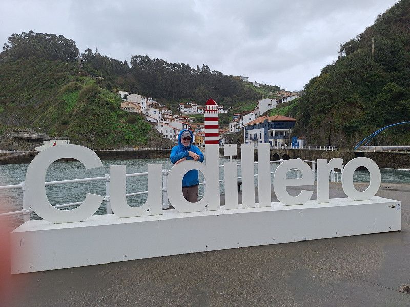
Cudillero
Carretera Las Dueñas - Puerto de Cudillero, Cudillero, Asturien, Spanien
43° 34' 5.1" N 6° 9' 11.4" W
43.5680730 -6.1531707
• Head northwest on CU-3. Go for 2.4 km.
• Take the 4th exit from roundabout onto A-8 (Autovía del Cantábrico) toward A Coruña. Go for 64.7 km.
• Take exit 495 toward Tapia de Casariego/La Roda. Go for 334 m.
• Take the 1st exit from roundabout onto AS-23 toward N-634/Navia/Avilés/Oviedo/Tapia de Casariego. Go for 1.7 km.
• Take the 2nd exit from roundabout onto AS-23. Go for 382 m.
• Take the 3rd exit from roundabout onto N-634. Go for 2.1 km.
• Turn sharp right toward Avenida General Primo de Rivera. Go for 555 m.
• Continue on Avenida General Primo de Rivera. Go for 423 m.
• Turn right onto Avenida San Esteban. Go for 124 m.
• Arrive at Avenida San Esteban. Your destination is on the left.
☍
72,7 km
( 42 min.)
24. Mar. 2025 -
24. Mar. 2025
Parking Playa Grande
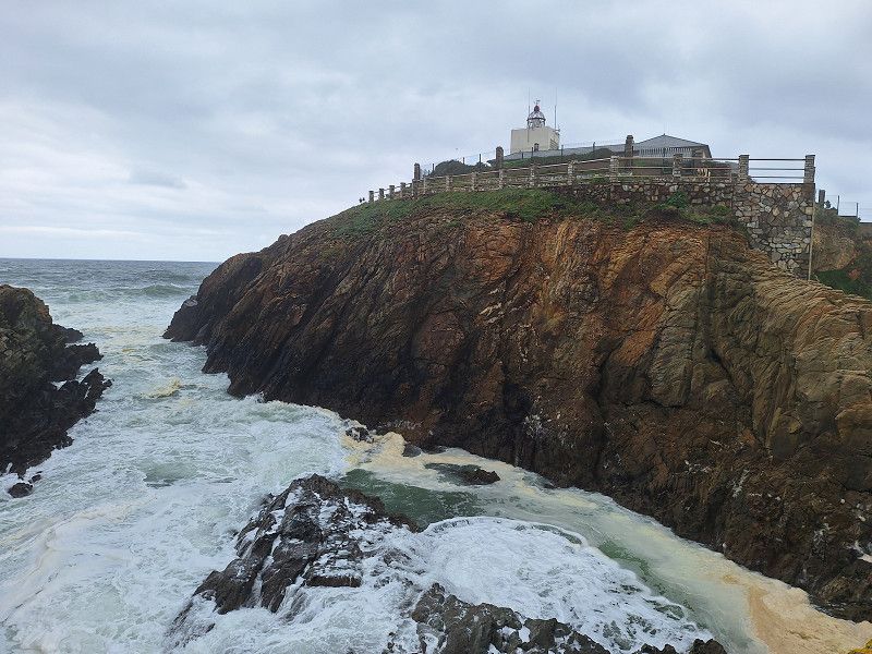
tour of the lighthouse and town
Av. San Esteban, 33740, Tapia de Casariego, Spanien
43° 33' 59" N 6° 56' 45" W
43.5663889 -6.9458333
• Head northwest on Avenida San Esteban. Go for 124 m.
• Turn left onto Avenida General Primo de Rivera. Go for 978 m.
• Turn right onto N-634. Go for 3.7 km.
• Take the 3rd exit from roundabout onto N-634. Go for 355 m.
• Take the 2nd exit from roundabout onto N-634 toward E-740/A-8/Oviedo/A Coruña/N-640/Barres/Castropol/Lugo/Vegadeo/Oscos-Eo. Go for 155 m.
• Take ramp onto A-8 (Autovía del Cantábrico) toward Ribadeo/A Coruña. Go for 4.8 km.
• Take exit 506 toward Ribadeo (Centro)/CP-5202/Vilaselán. Go for 289 m.
• Take the 4th exit from roundabout toward E-70/A-8/Oviedo/Ribadeo/N-634/Barreiros. Go for 154 m.
• Take the 1st exit from roundabout onto N-634. Go for 765 m.
• Pass 2 roundabouts. Go for 514 m.
• Arrive at your destination.
☍
11,8 km
( 12 min.)
24. Mar. 2025 -
25. Mar. 2025
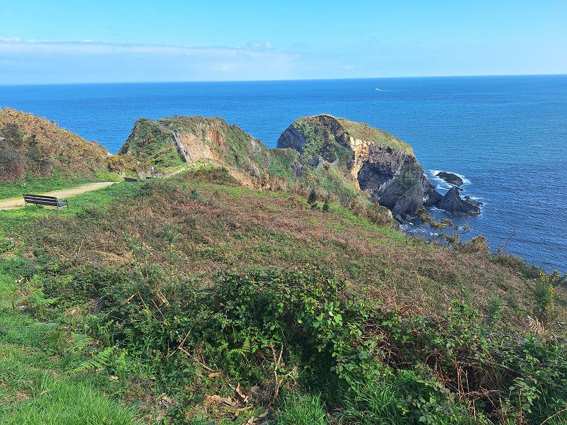
Ribadeo
Parking space in a supermarket parking lot. Short bike ride to the Ribadeo Lighthouse and through Ribadeo. The next morning, bike to Plaia de Cathedrals.
Saída aparcadoiro Eroski, Ribadeo, Lugo, Spanien
43° 32' 23.1" N 7° 3' 39.1" W
43.5397443 -7.0608730
• Head northwest. Go for 24 m.
• Make a U-Turn. Go for 178 m.
• Continue on Estrada Xeral. Go for 343 m.
• Take the 4th exit from roundabout onto N-634. Go for 365 m.
• Take the 3rd exit from roundabout onto Estrada da Mariña (N-634). Go for 777 m.
• Take the 3rd exit from roundabout onto N-634. Go for 758 m.
• Take the 2nd exit from roundabout onto O Alto dos Pinos (N-634). Go for 6.3 km.
• Take the 1st exit from roundabout onto Estrada LU-P-5206 toward Playa de as Catedrais. Go for 586 m.
• Take the 2nd exit from roundabout onto Estrada LU-P-5206. Go for 449 m.
• Turn right. Go for 12 m.
• Turn left. Go for 37 m.
• Arrive at your destination on the right.
☍
9,8 km
( 12 min.)
25. Mar. 2025 -
25. Mar. 2025
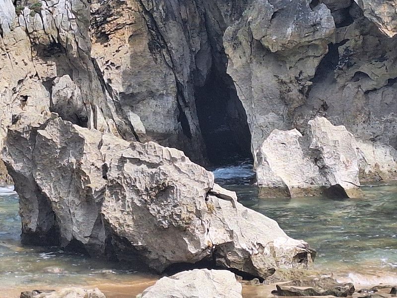
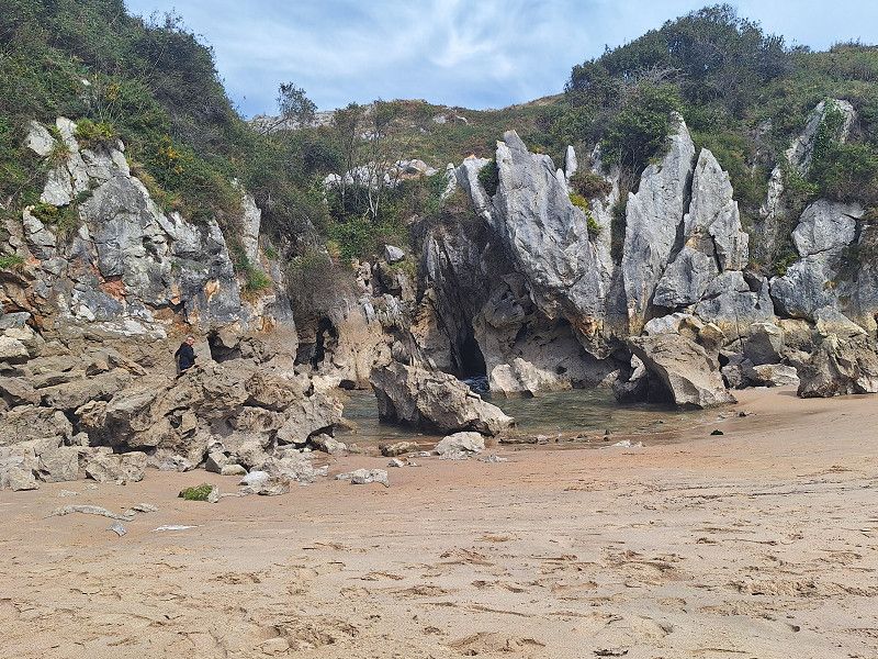
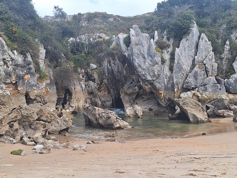
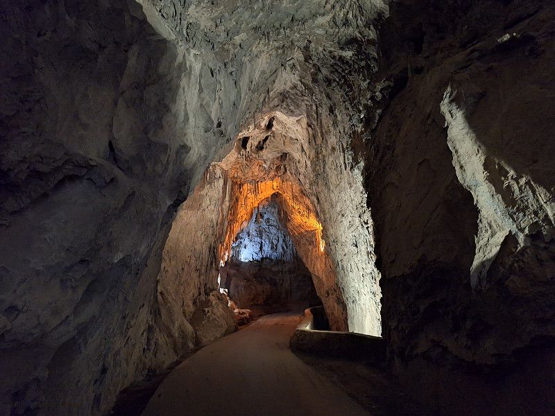
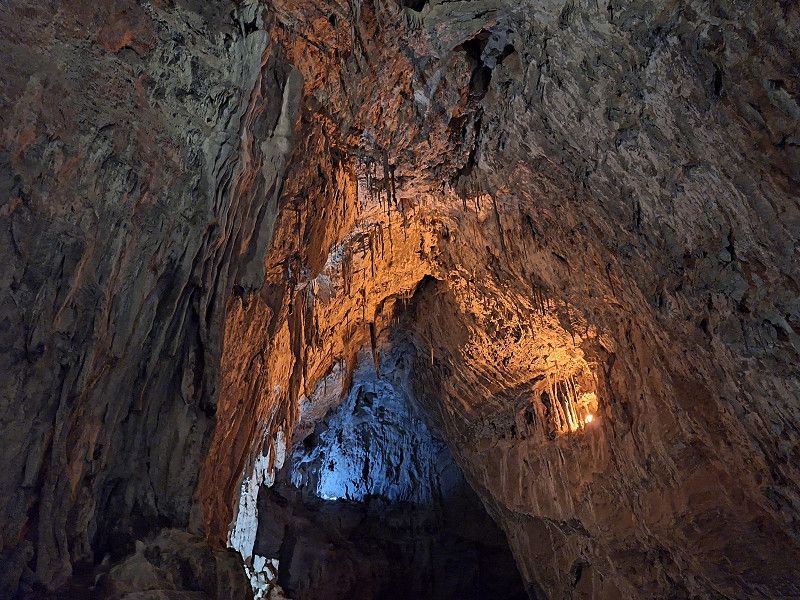
Playa de Cathedrals
Parking for visiting the Cathedrals Beach
LU-P-0610, 27795 Ribadeo, Lugo, Spanien
43° 33' 10.3" N 7° 9' 24.8" W
43.5528720 -7.1568890
• Head west. Go for 162 m.
• Turn left onto Estrada LU-P-5206. Go for 388 m.
• Take the 1st exit from roundabout onto Estrada LU-P-5206. Go for 574 m.
• Take the 1st exit from roundabout onto N-634 toward Reinante/Barreiros. Go for 8.4 km.
• Keep right onto A Anea. Go for 4.3 km.
• Pass 3 roundabouts and continue on Estrada Xeneral Fazouro (N-642). Go for 9.8 km.
• Continue on Vilachá (N-642). Go for 10.0 km.
• Take the 2nd exit from roundabout onto Espiñeirido (N-642). Go for 3.5 km.
• Turn sharp right onto O Castelo (N-642). Go for 213 m.
• Continue on Avenida de Lieiro (N-642). Go for 331 m.
• Continue on O Castelo (N-642). Go for 23 m.
• Continue on Lieiro (N-642). Go for 367 m.
• Continue on Lieiro (LU-P-1501). Go for 172 m.
• Continue on San Cibrao (LU-P-1501). Go for 27 m.
• Continue on Lieiro (LU-P-1501). Go for 39 m.
• Continue on San Cibrao (LU-P-1501). Go for 506 m.
• Turn left onto Lieiro. Go for 181 m.
• Arrive at your destination.
☍
38,9 km
( 37 min.)
25. Mar. 2025 -
27. Mar. 2025
San Cibreo
A Mariña Occidental, Galicien, Spanien
43° 41' 39.8" N 7° 27' 0.6" W
43.6943837 -7.4501562
• Head toward San Cibrao. Go for 92 m.
• Turn right onto Lieiro. Go for 111 m.
• Turn right onto San Cibrao (LU-P-1501). Go for 356 m.
• Turn left onto Lieiro (LU-P-1501). Go for 39 m.
• Continue on San Cibrao (LU-P-1501). Go for 27 m.
• Continue on Lieiro (LU-P-1501). Go for 539 m.
• Continue on O Castelo (N-642). Go for 23 m.
• Continue on Avenida de Lieiro (N-642). Go for 331 m.
• Continue on O Castelo (N-642). Go for 167 m.
• Turn right onto O Castelo (LU-862). Go for 1.3 km.
• Take the 2nd exit from roundabout onto Beltrán. Go for 337 m.
• Take the 1st exit from roundabout onto Vía de Altas Prestacións Costa Norte (CG-2.3) toward Viveiro/Celeiro. Go for 7.9 km.
• Take the 1st exit from roundabout onto LU-862. Go for 4.5 km.
• Take the 2nd exit from roundabout onto Avenida de Benito Galcerán (LU-862). Go for 285 m.
• Turn right onto Estrada a Coruña (LU-862). Go for 483 m.
• Take the 1st exit from Estrada Viveiro roundabout onto Misericordia (LU-862). Go for 2.1 km.
• Take the 3rd exit from roundabout onto LU-862. Go for 5.3 km.
• Turn right onto Suavila. Go for 340 m.
• Arrive at Suavila.
☍
24,2 km
( 26 min.)
27. Mar. 2025 -
28. Mar. 2025
O Vicedo
LU-862, O Vicedo, A Mariña Occidental, Galicien, Spanien
43° 43' 1.4" N 7° 37' 15.3" W
43.7170632 -7.6209043
• Head southwest on Suavila. Go for 305 m.
• Turn right onto Suavila. Go for 69 m.
• Turn right onto A Lama (LU-862). Go for 8.1 km.
• Continue on AC-862. Go for 1.1 km.
• Turn right onto Rúa Manuel Cora Rodríguez (AC-100). Go for 179 m.
• Continue on Rúa Rafael Campillo (AC-100). Go for 14 m.
• Continue on AC-100. Go for 259 m.
• Continue on O Porto do Barqueiro (AC-100). Go for 281 m.
• Continue on AC-100. Go for 2.6 km.
• Continue on Campelo (AC-100). Go for 1.1 km.
• Continue on AC-100. Go for 749 m.
• Continue on Campelo (AC-100). Go for 524 m.
• Turn left onto Camiño a Semáforo de Bares. Go for 36 m.
• Continue on Campelo. Go for 747 m.
• Continue on O Faro da Estaca de Bares. Go for 557 m.
• Arrive at O Faro da Estaca de Bares. Your destination is on the left.
☍
16,7 km
( 21 min.)
28. Mar. 2025 -
28. Mar. 2025
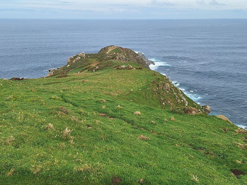
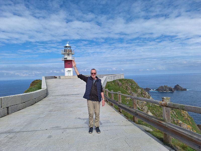
Estrada á Estaca de Bares, Ortegal, Galicien, Spanien
Drive and walk to the Faro de Bares.
43° 47' 3.4" N 7° 41' 3.8" W
43.7842676 -7.6843950
• Head toward Camiño a Semáforo de Bares on O Faro da Estaca de Bares. Go for 557 m.
• Continue on Campelo. Go for 747 m.
• Continue on Camiño a Semáforo de Bares. Go for 36 m.
• Turn right onto Campelo (AC-100). Go for 524 m.
• Continue on AC-100. Go for 749 m.
• Continue on Campelo (AC-100). Go for 1.1 km.
• Continue on AC-100. Go for 2.6 km.
• Continue on O Porto do Barqueiro (AC-100). Go for 281 m.
• Continue on AC-100. Go for 259 m.
• Continue on Rúa Rafael Campillo (AC-100). Go for 14 m.
• Continue on Rúa Manuel Cora Rodríguez (AC-100). Go for 179 m.
• Turn right onto Estrada de Viveiro (AC-862). Go for 11.2 km.
• Take the 2nd exit from roundabout. Go for 84 m.
• Continue on San Xoán. Go for 85 m.
• Take the 1st exit from roundabout onto CG-1.3. Go for 7.4 km.
• Take the 1st exit from roundabout onto AC-101 toward Polígono Industrial Cuiña/Ortigueira/AC-862/Ferrol. Go for 356 m.
• Take the 2nd exit from roundabout onto Estrada de As Pontes de García Rodríguez (AC-101). Go for 775 m.
• Take the 2nd exit from roundabout onto Santiago (AC-862). Go for 6.1 km.
• Turn right onto CP-6121. Go for 113 m.
• Continue on A Ponte de Mera (CP-6121). Go for 796 m.
• Continue on Veiga (CP-6121). Go for 323 m.
• Continue on CP-6121. Go for 45 m.
• Continue on Veiga (CP-6121). Go for 792 m.
• Continue on CP-6121. Go for 273 m.
• Continue on Esteiro de Abaixo (CP-6121). Go for 386 m.
• Continue on Rúa Nova (CP-6121). Go for 9 m.
• Continue on Esteiro de Arriba (CP-6121). Go for 212 m.
• Continue on Rúa de Abaixo (CP-6121). Go for 93 m.
• Continue on A Adega (CP-6121). Go for 345 m.
• Continue on O Barral (CP-6121). Go for 236 m.
• Continue on Condomiña (CP-6121). Go for 299 m.
• Continue on CP-6121. Go for 991 m.
• Continue on Cabanán de Arriba (CP-6121). Go for 118 m.
• Continue on A Lama-Sismundi (CP-6121). Go for 15 m.
• Continue on CP-6121. Go for 286 m.
• Continue on A Lama-Sismundi (CP-6121). Go for 152 m.
• Continue on O Souto Chao (CP-6121). Go for 339 m.
• Continue on O Pazo (CP-6121). Go for 105 m.
• Continue on O Areado (CP-6121). Go for 217 m.
• Continue on O Carballo (CP-6121). Go for 80 m.
• Continue on Vimbieiro (CP-6121). Go for 474 m.
• Continue on CP-6121. Go for 81 m.
• Continue on Reboredo-Sismundi (CP-6121). Go for 492 m.
• Continue on CP-6121. Go for 104 m.
• Continue on A Ortigueira (CP-6121). Go for 153 m.
• Continue on CP-6121. Go for 27 m.
• Continue on A Ortigueira (CP-6121). Go for 289 m.
• Continue on A Basanta (CP-6121). Go for 118 m.
• Continue on A Castiñeira (CP-6121). Go for 181 m.
• Continue on A Cerca (CP-6121). Go for 459 m.
• Continue on Rúa Sagrón. Go for 485 m.
• Continue on Avenida da Constitución. Go for 883 m.
• Turn left onto Rúa Balbís. Go for 61 m.
• Turn slightly left onto Rúa Balbís. Go for 99 m.
• Turn slightly right onto Praza Mariña Española. Go for 36 m.
• Turn left onto Praza Mariña Española. Go for 25 m.
• Continue on Rúa Landín Carrasco. Go for 8 m.
• Turn right onto Rúa Centeas. Go for 258 m.
• Turn slightly left onto Barrio Cariño. Go for 107 m.
• Continue on Cariño. Go for 3.6 km.
• Arrive at Cariño.
☍
47,2 km
( 55 min.)
28. Mar. 2025 -
28. Mar. 2025
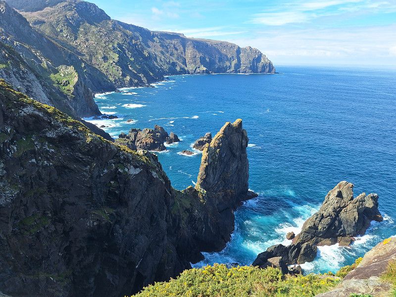
Cabo Ortegal
Miradoiro da Malveira 2, Cariño, Ortegal, Galicien, Spanien
43° 46' 25.2" N 7° 52' 6.7" W
43.7736728 -7.8685317
• Head southeast on Cariño. Go for 3.6 km.
• Continue on Barrio Cariño. Go for 107 m.
• Turn right onto Rúa Santa María. Go for 268 m.
• Turn left onto Rúa Landín Carrasco. Go for 34 m.
• Turn right onto Praza Mariña Española. Go for 26 m.
• Continue on Rúa Balbís. Go for 160 m.
• Turn right onto Avenida da Constitución. Go for 883 m.
• Continue on Rúa Sagrón. Go for 485 m.
• Continue on Estrada a Mera (CP-6121). Go for 459 m.
• Continue on A Castiñeira (CP-6121). Go for 181 m.
• Continue on A Basanta (CP-6121). Go for 118 m.
• Continue on A Ortigueira (CP-6121). Go for 289 m.
• Continue on CP-6121. Go for 27 m.
• Continue on A Ortigueira (CP-6121). Go for 153 m.
• Continue on CP-6121. Go for 104 m.
• Continue on Reboredo-Sismundi (CP-6121). Go for 492 m.
• Continue on CP-6121. Go for 81 m.
• Continue on Vimbieiro (CP-6121). Go for 474 m.
• Continue on O Carballo (CP-6121). Go for 80 m.
• Continue on O Areado (CP-6121). Go for 217 m.
• Continue on O Pazo (CP-6121). Go for 105 m.
• Continue on O Souto Chao (CP-6121). Go for 339 m.
• Continue on A Lama-Sismundi (CP-6121). Go for 152 m.
• Keep right onto CP-6121. Go for 286 m.
• Continue on A Lama-Sismundi (CP-6121). Go for 15 m.
• Continue on Cabanán de Arriba (CP-6121). Go for 118 m.
• Continue on CP-6121. Go for 991 m.
• Continue on Condomiña (CP-6121). Go for 299 m.
• Continue on O Barral (CP-6121). Go for 236 m.
• Continue on A Adega (CP-6121). Go for 345 m.
• Continue on Rúa de Abaixo (CP-6121). Go for 93 m.
• Continue on Esteiro de Arriba (CP-6121). Go for 212 m.
• Continue on Rúa Nova (CP-6121). Go for 9 m.
• Continue on Esteiro de Abaixo (CP-6121). Go for 386 m.
• Continue on CP-6121. Go for 273 m.
• Continue on Veiga (CP-6121). Go for 792 m.
• Continue on CP-6121. Go for 45 m.
• Continue on Veiga (CP-6121). Go for 323 m.
• Continue on A Ponte de Mera (CP-6121). Go for 796 m.
• Continue on CP-6121. Go for 113 m.
• Turn right onto AC-862. Go for 10.8 km.
• Continue on Lugar Felgosas (AC-862). Go for 780 m.
• Keep right onto AC-862. Go for 1.2 km.
• Keep right toward AC-862. Go for 327 m.
• Turn right onto AC-862. Go for 12.2 km.
• Take the 2nd exit from roundabout onto AC-862. Go for 1.8 km.
• Take ramp onto AG-64 (Autovía Ferrol-Vilalba) toward Ferrol. Go for 9.8 km.
• Take exit 3 toward AP-9/FE-11/Pol. Industrial Río do Pozo. Go for 285 m.
• Turn left onto Avenida Bernando Romero (FE-12) toward Pol. Ind. Río do Pozo/AC-113/Narón. Go for 407 m.
• Pass 2 roundabouts and continue on FE-12. Go for 3.2 km.
• Take the 1st exit from roundabout onto AP-9 (Autoestrada do Atlántico) toward Ferrol. Go for 2.1 km.
• Continue on FE-15 (Estrada Acceso Norte). Go for 2.3 km.
• Take ramp toward La Malata. Go for 366 m.
• Take the 1st exit from roundabout onto Feria de Mostras. Go for 75 m.
• Turn left onto Feria de Mostras. Go for 181 m.
• Turn right onto Feria de Mostras. Go for 224 m.
• Arrive at Feria de Mostras. Your destination is on the left.
☍
60,1 km
(1 hrs. )
28. Mar. 2025 -
29. Mar. 2025
Parking Malata in Ferrol
Ctra de la Malata, 15402, Ferrol, Spanien
43° 29' 36" N 8° 14' 24" W
43.4933333 -8.2400000
• Head northeast on Feria de Mostras. Go for 73 m.
• Take the 2nd exit from roundabout onto Estrada da Malata. Go for 286 m.
• Keep right onto Estrada da Malata. Go for 84 m.
• Continue on Rúa de Botana. Go for 169 m.
• Turn right onto Lugar Parroquia Serantes. Go for 235 m.
• Turn left onto Barrio O Coto. Go for 98 m.
• Continue on Rúa Puerta de Neira. Go for 21 m.
• Continue on Rúa Porta Neira. Go for 130 m.
• Continue on Rúa Puerta de Neira. Go for 354 m.
• Continue on Estrada Catabois (AC-116). Go for 1.1 km.
• Continue on AC-116. Go for 30 m.
• Continue on Estrada Catabois (AC-116). Go for 576 m.
• Continue toward Barrio Catabois. Go for 45 m.
• Take the 4th exit from roundabout onto Estrada Catabois (AC-116). Go for 1.2 km.
• Take the 2nd exit from Lugar Muíño Vento roundabout onto AG-64 (Autovía Ferrol-Vilalba) toward As Pontes/Vilalba. Go for 56.2 km.
• Take the 2nd exit from roundabout onto A-8 (Autovía do Cantábrico) toward Lugo/A Coruña. Go for 17.1 km.
• Take the left exit toward Lugo/Madrid onto A-6 (Autovía do Noroeste). Go for 21.3 km.
• Take exit 500 toward Pol. Industrial O Ceao/Lugo/N-6/Ourense/N-540 onto Avenida Benigno Rivera. Go for 1.5 km.
• Take the 2nd exit from roundabout onto Avenida Benigno Rivera. Go for 155 m.
• Take the 3rd exit from roundabout onto Avenida Benigno Rivera. Go for 326 m.
• Take the 3rd exit from roundabout onto Avenida Benigno Rivera. Go for 554 m.
• Take the 2nd exit from roundabout onto Avenida Benigno Rivera. Go for 544 m.
• Take the 3rd exit from roundabout onto Estrada da Coruña N-6. Go for 239 m.
• Continue on Estrada da Coruña (N-6). Go for 4.7 km.
• Take ramp toward Rúa Santiago. Go for 117 m.
• Turn sharp left onto Estrada de Santiago (LU-232). Go for 171 m.
• Continue on Rúa de Santiago. Go for 399 m.
• Turn sharp right toward Ronda da República Argentina. Go for 106 m.
• Continue on Ronda da República Argentina. Go for 19 m.
• Turn left. Go for 76 m.
• Arrive at your destination.
☍
107,9 km
(1 hrs. 10 min.)
29. Mar. 2025 -
30. Mar. 2025
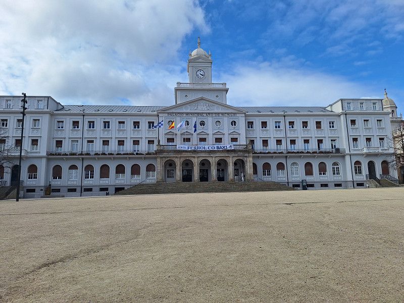
Área de Autocaravanas
Hike on the city wall and old town
Calle de Santiago, 27001, Lugo, Spanien
43° 0' 16" N 7° 33' 41" W
43.0044444 -7.5613889
• Head southeast. Go for 63 m.
• Turn right toward Ronda da República Argentina. Go for 84 m.
• Continue on Ronda da República Argentina. Go for 125 m.
• Turn sharp left onto Rúa de Santiago. Go for 399 m.
• Continue on Estrada de Santiago (LU-232). Go for 140 m.
• Turn right and take ramp onto N-6. Go for 2.2 km.
• Pass 2 roundabouts and continue on N-6. Go for 3.0 km.
• Take the 4th exit from roundabout onto LU-11. Go for 2.1 km.
• Take the 5th exit from roundabout onto A-6 (Autovía do Noroeste) toward Madrid. Go for 84.4 km.
• Take exit 405 toward Toral de los Vados/N-120/O Barco de Valdeorras/Ourense onto N-6. Go for 2.0 km.
• Take the 3rd exit from roundabout onto N-6 toward A-6/Ponferrada/Madrid/N-120/Ourense. Go for 1.1 km.
• Take ramp onto N-120 toward O Barco/Monforte de Lemos/Ourense. Go for 10.1 km.
• Take ramp toward La Barosa/Lago de Carucedo. Go for 216 m.
• Turn left. Go for 2.7 km.
• Continue toward Calle Calella. Go for 544 m.
• Continue on Calle Calella. Go for 645 m.
• Turn left onto N-536. Go for 2.0 km.
• Turn right onto Calle Médulas. Go for 524 m.
• Continue on Carretera Las Médulas (LE-6202). Go for 75 m.
• Turn right. Go for 47 m.
• Arrive at your destination.
☍
112,5 km
(1 hrs. 16 min.)
29. Mar. 2025 -
30. Mar. 2025
Carucedo
Calle Médulas, Carucedo, El Bierzo, Kastilien und León, Spanien
42° 29' 10.9" N 6° 45' 40.8" W
42.4863556 -6.7613204
• Head toward Carretera Las Médulas. Go for 47 m.
• Turn right onto Carretera Las Médulas (LE-6202). Go for 3.2 km.
• Continue on Carretera Carucedo (LE-6202). Go for 82 m.
• Turn slightly left onto Carretera Carucedo (LE-6202). Go for 350 m.
• Turn right onto Camino Lleres. Go for 11 m.
• Arrive at Camino Lleres. Your destination is on the right.
☍
3,7 km
( 6 min.)
Carucedo
Calle las Cuevas 5, Carucedo, León, Spanien
42° 27' 25.2" N 6° 46' 4.6" W
42.4570016 -6.7679362
• Head southwest on Camino Lleres. Go for 45 m.
• Turn right onto Calle Horno. Go for 97 m.
• Turn left onto Carretera Carucedo (LE-6202). Go for 373 m.
• Continue on Carretera Las Médulas (LE-6202). Go for 3.2 km.
• Continue on Calle Médulas. Go for 524 m.
• Turn right onto Calle Carretera (N-536). Go for 14.7 km.
• Take ramp. Go for 252 m.
• Take the 2nd exit from roundabout onto Calle Madrigal (N-120). Go for 1.0 km.
• Continue on N-120. Go for 205 m.
• Continue on Avenida de Portugal. Go for 2.4 km.
• Pass 2 roundabouts and continue on Avenida de Portugal. Go for 852 m.
• Take the 2nd exit from Glorieta del Caballero Templario roundabout onto Avenida de España. Go for 141 m.
• Turn right onto Avenida El Castillo. Go for 582 m.
• Take the 3rd exit from Plaza Luis del Olmo roundabout onto Calle Ortega y Gasset. Go for 276 m.
• Continue on Calle San Juan Apóstol. Go for 157 m.
• Turn slightly right onto Plaza San Pedro. Go for 19 m.
• Turn right onto Avenida de la Puebla. Go for 61 m.
• Turn right onto Travesía El Rio. Go for 157 m.
• Continue on Avenida del Sil. Go for 23 m.
• Arrive at Avenida del Sil. Your destination is on the left.
☍
25,1 km
( 33 min.)
03. Apr. 2025 -
04. Apr. 2025
Compostilla
Avenida del Sil, Compostilla, León, Spanien
42° 32' 43.5" N 6° 35' 37.9" W
42.5454124 -6.5938719
• Head southwest on Avenida del Sil. Go for 108 m.
• Turn right onto Calle Carlos I. Go for 88 m.
• Continue on Calle Gregoria Campillo. Go for 204 m.
• Turn right onto Avenida de la Puebla. Go for 200 m.
• Continue on Calle General Vives. Go for 37 m.
• Pass 2 roundabouts and continue on Calle General Vives. Go for 858 m.
• Take the 2nd exit from roundabout onto Avenida Astorga. Go for 478 m.
• Take the 3rd exit from roundabout onto Avenida Montearenas. Go for 519 m.
• Take the 3rd exit from roundabout onto Avenida Montearenas. Go for 632 m.
• Continue on N-6. Go for 1.1 km.
• Take ramp onto A-6 (Autovía del Noroeste) toward Astorga/Madrid. Go for 59.5 km.
• Take exit 324 toward Astorga/N-6/León/N-120/Aeropuerto onto AP-71. Go for 37.7 km.
• Take exit 1 toward Madrid/Burgos onto A-66 (Autovía Ruta de la Plata). Go for 9.1 km.
• Take exit 152 toward Onzonilla/León/LE-11/Burgos onto A-231 (Autovía Camino de Santiago). Go for 107 km.
• Take exit 106 toward Santander onto A-67 (Autovía Cantabria-Meseta). Go for 46.1 km.
• Take exit 100 toward Aguilar de Campoó/Palencia/Santander. Go for 343 m.
• Take the 3rd exit from roundabout onto N-611 toward Aguilar de Campoó/Santander/Herrera de Pisuerga/A-67/Palencia. Go for 181 m.
• Take the 1st exit from roundabout onto N-611 toward Aguilar de Campoó/Santander. Go for 3.2 km.
• Turn sharp right. Go for 178 m.
• Turn right. Go for 318 m.
• Continue toward Calle Molino Turruntero. Go for 116 m.
• Turn left onto Calle Molino Turruntero. Go for 200 m.
• Turn right onto Paseo del Soto. Go for 20 m.
• Arrive at Paseo del Soto. Your destination is on the right.
☍
268,0 km
(2 hrs. 23 min.)
04. Apr. 2025 -
05. Apr. 2025
Área Las Campas
Paseo del Soto 19, 34800, Aguilar de Campóo, Spanien
42° 47' 17" N 4° 15' 29" W
42.7880556 -4.2580556
• Head north on Paseo del Soto. Go for 361 m.
• Turn right onto Calle Marqués de Aguilar. Go for 118 m.
• Turn left onto Avenida Ciudad Deportiva. Go for 93 m.
• Continue on Paseo de las Tenerías. Go for 43 m.
• Continue on Avenida Constitución. Go for 171 m.
• Turn slightly right onto Calle Matías Barrio y Mier. Go for 10 m.
• Take the 1st exit from roundabout onto N-627. Go for 124 m.
• Turn left onto Avenida de Santander (N-611). Go for 830 m.
• Continue on N-611. Go for 59 m.
• Turn slightly left onto N-611. Go for 2.3 km.
• Take the 2nd exit from roundabout onto N-611. Go for 770 m.
• Continue on Carretera Quintanilla de las Torres (N-611). Go for 45 m.
• Continue on N-611. Go for 132 m.
• Take the 2nd exit from roundabout onto Carretera Quintanilla de las Torres (N-611). Go for 761 m.
• Take the 1st exit from roundabout onto Carretera Quintanilla de las Torres (N-611). Go for 876 m.
• Continue on Carretera General de Polientes (N-611). Go for 116 m.
• Turn right onto Carretera General de Polientes (P-621). Go for 217 m.
• Continue on P-621. Go for 950 m.
• Continue on CA-273. Go for 1.0 km.
• Continue on Calle Real (CA-273). Go for 249 m.
• Continue on CA-273. Go for 2.9 km.
• Continue on Barrio San Martín de Valdelomar (CA-273). Go for 507 m.
• Continue on CA-273. Go for 1.5 km.
• Continue on Barrio Castrillo de Valdelomar (CA-273). Go for 363 m.
• Continue on CA-273. Go for 5.8 km.
• Continue on Barrio Villanueva de la Nía (CA-273). Go for 898 m.
• Continue on CA-273. Go for 490 m.
• Take the 1st exit from roundabout onto CA-272. Go for 3.5 km.
• Continue on Calle del Ebro (CA-272). Go for 257 m.
• Continue on CA-272. Go for 4.1 km.
• Continue on Poblado la Puente del Valle (CA-272). Go for 1.9 km.
• Continue on CA-272. Go for 640 m.
• Continue on Calle Carretera General (CA-272). Go for 347 m.
• Continue on Poblado Campo de Ebro (CA-272). Go for 160 m.
• Continue on CA-272. Go for 2.0 km.
• Continue on Barrio Polientes (CA-272). Go for 1.3 km.
• Continue on CA-272. Go for 14 m.
• Continue on CA-274. Go for 4.0 km.
• Take the 1st exit from roundabout onto CA-275. Go for 8.2 km.
• Continue on BU-643. Go for 4.5 km.
• Arrive at BU-643. Your destination is on the left.
☍
52,7 km
( 50 min.)
05. Apr. 2025 -
06. Apr. 2025
Valle De Sedano
Calle la Iglesia, Valle De Sedano, Burgos, Spanien
42° 50' 6.7" N 3° 47' 34" W
42.8351852 -3.7927758
• Head toward Calle Iglesia on BU-643. Go for 4.5 km.
• Continue on Calle Carretera (BU-643). Go for 610 m.
• Continue on BU-643. Go for 290 m.
• Turn right onto N-623. Go for 41.5 km.
• Turn left onto N-623/N-627. Go for 4.1 km.
• Continue on A-73 (Autovía Burgos Aguilar de Campoo). Go for 9.0 km.
• Take exit 1 toward Quintanadueñas/Polígono Industrial de Villalonquéjar/Centro Ciudad Burgos/N-623/N-627/Quintanilla Vivar. Go for 690 m.
• Take the 2nd exit from roundabout toward Burgos/N-623/N-627/Quintanilla Vivar/Villarcayo/CL-629/Pol. Industrial Villalonquéjar. Go for 638 m.
• Take the 2nd exit from roundabout onto Calle de Laredo toward Burgos/Pol. Industrial Villalonquéjar. Go for 638 m.
• Pass 3 roundabouts and continue on Calle de Laredo. Go for 1.6 km.
• Continue on N-623/N-627. Go for 693 m.
• Take the 2nd exit from Plaza Félix Rodríguez de la Fuente roundabout onto Avenida de Cantabria (N-623/N-627) toward Centro Ciudad. Go for 351 m.
• Pass 2 roundabouts and continue on Avenida de Cantabria (N-623/N-627). Go for 1.4 km.
• Take ramp toward Parque de Fuentes Blancas. Go for 150 m.
• Take the 1st exit from roundabout onto Calle de la Cartuja de Miraflores (N-120) toward León/Calle Molinillo. Go for 644 m.
• Take the 3rd exit from roundabout. Go for 78 m.
• Continue on Calle de la Cartuja de Miraflores. Go for 4 m.
• Turn left. Go for 89 m.
• Arrive at your destination on the left.
☍
67,0 km
( 54 min.)
06. Apr. 2025 -
07. Apr. 2025
Parking Autocaravanas
Calle de Cartuja de Miraflores, 09001, Burgos, Spanien
42° 20' 26" N 3° 41' 36" W
42.3405556 -3.6933333
• Head toward Calle de la Cartuja de Miraflores. Go for 89 m.
• Turn right onto Calle de la Cartuja de Miraflores. Go for 17 m.
• Take the 1st exit from roundabout onto Calle de la Cartuja de Miraflores (N-120). Go for 622 m.
• Take the 2nd exit from roundabout onto BU-11 (Carretera Madrid a Irún) toward León/Valladolid/Palencia/A-62/Madrid/Soria/E-5/A-1/N-234/Vitoria/AP-1/Bilbao/N-1/Logroño/N-120. Go for 443 m.
• Take exit 1B toward E-5/A-1/Vitoria/AP-1/Logroño/N-120. Go for 155 m.
• Take the 2nd exit from roundabout. Go for 1.6 km.
• Continue toward Autovía del Norte/A-1. Go for 56 m.
• Take the 2nd exit from roundabout onto A-1 (Autovía del Norte) toward Vitoria/Logroño. Go for 5.1 km.
• Continue on AP-1 (Autovía del Norte). Go for 72.2 km.
• Take exit 74 toward Miranda de Ebro/BU-535/Puentelarrá/A-2122. Go for 635 m.
• Take the 3rd exit from roundabout onto BU-535 toward Miranda de Ebro. Go for 1.0 km.
• Take the 3rd exit from roundabout onto Carretera de Bilbao (BU-535). Go for 775 m.
• Take the 1st exit from Carretera de Bilbao roundabout onto Carretera Madrid-Irún (N-1). Go for 505 m.
• Take the 1st exit from roundabout onto Calle de Burgos. Go for 247 m.
• Turn right onto Camino de los Pinos. Go for 36 m.
• Arrive at Camino de los Pinos. Your destination is on the left.
☍
83,4 km
( 50 min.)
07. Apr. 2025 -
08. Apr. 2025
Área de Autocaravanas del Ebro
Camina de los Pinos, 09200, Miranda de Ebro, Spanien
42° 41' 19" N 2° 57' 18" W
42.6886111 -2.9550000
• Head toward Calle de Burgos on Camino de los Pinos. Go for 36 m.
• Turn left onto Calle de Burgos. Go for 205 m.
• Take the 4th exit from roundabout onto Calle de Burgos (N-1) toward E-5/AP-1/Burgos/E-804/AP-68/Bilbao/Logroño. Go for 582 m.
• Pass 2 roundabouts and continue on Calle California (N-1). Go for 2.3 km.
• Take the 3rd exit from roundabout onto A-1. Go for 30.7 km.
• Take exit 352 toward E-80/Francia/AP-1/Bilbao/AP-68/Aireportua onto N-622. Go for 2.3 km.
• Take ramp toward Aireportua/Foronda/Etxabarri-Ibiña/Donostia/AP-1/San Sebastián. Go for 273 m.
• Keep left toward Autopista Vitoria-Eibar/AP-1. Go for 862 m.
• Take ramp onto AP-1 (Autopista Vitoria-Eibar) toward Donostia/San Sebastián. Go for 44.7 km.
• Take the exit onto AP-1/AP-8 (Autopista del Cantábrico). Go for 42.6 km.
• Take the exit toward Hernani/Pasaia/Irun/Baiona/Bordeaux onto AP-1/AP-8 (Segundo Cinturón de San Sebastián). Go for 14.6 km.
• Take the exit onto AP-8. Go for 12.7 km.
• Continue on A63 (Autoroute de la Côte Basque). Go for 206 km.
• Take the exit toward Paris/Toulouse/Bordeaux/Talence onto A630 (Rocade de Bordeaux). Go for 9.2 km.
• Keep left onto Rocade de Bordeaux (N230) toward Paris/A10/Lyon/A89. Go for 8.4 km.
• Take ramp onto N89 toward Périgueux/Libourne/Yvrac. Go for 18.5 km.
• Keep left onto A89 toward Lyon/Périgueux/Bergerac/Libourne-Nord. Go for 167 km.
• Take the left exit toward Paris/Limoges/Lyon/A89/Clermont-Fd/Tulle/Brive-Est onto A20 (L'Occitane). Go for 16.7 km.
• Take exit 46.1 toward Lyon/Clermont-Fd/Tulle/St-Germain les V. onto A89. Go for 161 km.
• Take the left exit toward E11/Paris/Montluçon/Vichy onto A71. Go for 46.6 km.
• Take exit 11 toward Commentry/Montmarault/St Pourçain S/S. Go for 1.3 km.
• Take the 3rd exit from roundabout onto D46 toward St Pourçain S/S. Go for 579 m.
• Take the 2nd exit from roundabout onto D46 toward Vichy/Roanne/St Pourçain S/S. Go for 2.4 km.
• Turn left onto D429 toward St Marcel en M. Go for 27 m.
• Turn right onto D429. Go for 213 m.
• Continue on Lieu-dit Le Bourg (D429). Go for 104 m.
• Turn left. Go for 17 m.
• Arrive at your destination on the left.
☍
789,3 km
(6 hrs. 55 min.)
08. Apr. 2025 -
09. Apr. 2025
Aire de Camping-cars
Le Bourg, 03390, St.-Marcel-en-Murat, Frankreich
46° 19' 18" N 3° 0' 27" E
46.3216667 3.0075000
• Head toward Lieu-dit Le Bourg. Go for 17 m.
• Turn right onto Lieu-dit Le Bourg (D429). Go for 104 m.
• Continue on D429. Go for 213 m.
• Turn left onto D429. Go for 27 m.
• Turn right onto D46. Go for 2.3 km.
• Take the 2nd exit from roundabout onto D46 toward Montluçon/Montmarault. Go for 533 m.
• Take the 1st exit from roundabout onto D2371 toward Moulins. Go for 697 m.
• Take the 2nd exit from roundabout onto E62 toward N79/Mâcon/Moulins/Bourbon-l'Arch./Deux-Chaises. Go for 496 m.
• Continue on A79. Go for 90.5 km.
• Continue on N79. Go for 10.1 km.
• Continue on N70. Go for 43.7 km.
• Take the 2nd exit from Rond-Point Jeanne Rose roundabout onto N80 toward A6/Chalon S/S./A6/Chalon. Go for 26.6 km.
• Take the 1st exit from Giratoire de Cortelin roundabout onto Route Express Chalon Montceau (N80) toward Chalon S/Saône. Go for 450 m.
• Turn right toward A6/Paris/Dijon/Lyon/Bourg en B./Mâcon. Go for 332 m.
• Take ramp onto A6 (Autoroute du Soleil) toward Paris/Dijon. Go for 31.1 km.
• Continue on A31. Go for 5.3 km.
• Take the exit toward Mulhouse/Besançon/Dole onto A36 (La Comtoise). Go for 164 km.
• Keep left onto A36 (La Comtoise) toward Strasbourg/Mulhouse/Belfort/Montbéliard. Go for 20.0 km.
• Take exit 13. Go for 326 m.
• Take the 1st exit from roundabout onto Grande Rue (D419) toward Paris/Lyon/Montbéliard/Belfort/Glacis du Château. Go for 540 m.
• Continue on Boulevard Pierre Mendès France (D583). Go for 1.1 km.
• Turn right onto Avenue de la Miotte. Go for 129 m.
• Arrive at Avenue de la Miotte.
☍
398,3 km
(3 hrs. 35 min.)
09. Apr. 2025 -
10. Apr. 2025
Aire de Camping-cars 2 Avenue de la Miotte, 90000, Belfort, Frankreich
2 Avenue de la Miotte, 90000 Belfort, Frankreich
47° 38' 33.9" N 6° 51' 55.2" E
47.6427618 6.8653443
• Head toward Avenue Capitaine de la Laurencie on Avenue de la Miotte. Go for 129 m.
• Turn left onto Avenue Capitaine de la Laurencie (D83). Go for 226 m.
• Continue on Avenue Capitaine de la Laurencie (D583) toward A36/Bâle/Glacis du Château/Z.A. de la Justice/P.A. des Hauts de Belfort. Go for 1.4 km.
• Take the 3rd exit from roundabout onto A36 (La Comtoise) toward Bâle/Strasbourg/Colmar/Mulhouse. Go for 43.1 km.
• Take the exit toward A35/E25/Strasbourg/Colmar onto Échangeur de Bâle-Mulhouse. Go for 2.4 km.
• Continue on A35. Go for 38.3 km.
• Continue on D83. Go for 10.7 km.
• Keep left onto A35. Go for 39.0 km.
• Keep left onto A355 toward E25/A4/Paris/A35/Karlsruhe/Strasbourg. Go for 23.6 km.
• Keep right toward A35/A4/Schiltigheim/Karlsruhe/Lauterbourg/Hoerdt. Go for 2.5 km.
• Continue on A35. Go for 47.0 km.
• Continue on B9. Go for 10.7 km.
• Keep right onto B9 toward Gewerbegebiet Horst/A65. Go for 228 m.
• Take the left exit toward Ludwigshafen/Landau/Speyer/Kandel-Nord/Gewerbegebiet Horst onto A65. Go for 49.6 km.
• Take exit 7 toward Koblenz/Mainz onto A61. Go for 220 km.
• Keep left onto A1 toward Dortmund/Flughafen Köln/Hürth. Go for 23.4 km.
• Take exit 101 toward Krefeld/Düsseldorf onto A57. Go for 77.2 km.
• Take exit 6 toward Alpen/Wesel/Geldern/Issum. Go for 323 m.
• Turn right onto Weseler Straße (B58). Go for 5.6 km.
• Arrive at Weseler Straße (B58).
☍
595,3 km
(5 hrs. 43 min.)
Wieder daheim
B 58, Issum, Kreis Kleve, Nordrhein-Westfalen, Deutschland
51° 31' 57.7" N 6° 25' 48.5" E
51.5326937 6.4301502