Our second winter in Spain and Portugal
Three overnight stays in France are planned during the journey.
After a week, we want to be in Malaga.
This time with more and shorter stops.
The maximum stay in one place is 10 days.
We're also going back to Portugal:
Luz and Porto Covo
We particularly enjoyed it there last time.
It's advisable to reserve places.
The experience of the first trip proved this.
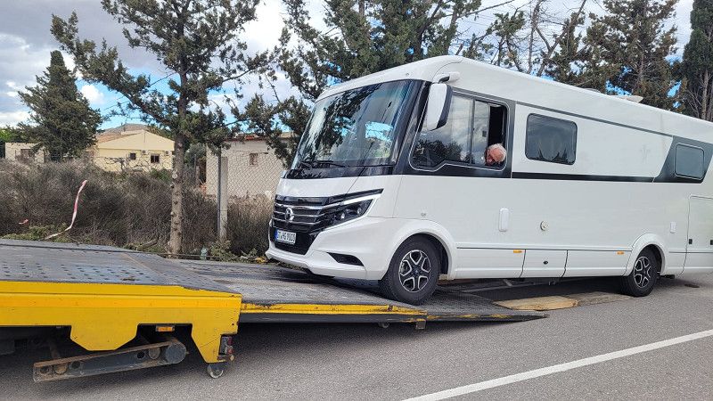
Unplanned end of the tour in Alicante
Ducato transmission defective. 12,600 km mileage. Horrible
The car will stay in Spain for repairs.
We're flying home
Beim Hofe
Beim Hofe 5, Bielefeld, Nordrhein-Westfalen, Deutschland
52° 4' 34.2" N 8° 30' 43.8" E
52.0761560 8.5121622
• Head toward Johanne-Kötter-Straße on Beim Hofe. Go for 85 m.
• Turn right onto Johanne-Kötter-Straße. Go for 67 m.
• Turn left onto Bohlestraße. Go for 171 m.
• Turn right onto Jöllenbecker Straße (L783). Go for 5.1 km.
• Turn left and take ramp onto Ostwestfalendamm (B61) toward Dortmund/A2/Osnabrück/A30/Paderborn/A33/Münster/Gütersloh. Go for 3.7 km.
• Keep left onto Ostwestfalendamm (B61) toward Dortmund/A2/Paderborn/B68/Münster/Gütersloh. Go for 3.3 km.
• Keep left onto B61N toward A33/Paderborn. Go for 675 m.
• Take ramp onto A33. Go for 51.7 km.
• Take exit 31 toward Kassel onto A44. Go for 67.6 km.
• Take the exit toward Marburg/Fritzlar/Baunatal onto A49 (Südtangente). Go for 79.5 km.
• Take the left exit onto A5. Go for 111 km.
• Take the exit toward Basel/Karlsruhe onto A5. Go for 244 km.
• Take exit 64A toward Bad Krozingen/Staufen/Münstertal/Colmar/Breisach. Go for 216 m.
• Turn left onto B31 toward Breisach/Colmar (Elsaß)/Hartheim/Hausen/Möhlin. Go for 10.3 km.
• Take the 2nd exit from roundabout onto B31 toward Colmar. Go for 612 m.
• Continue on D415. Go for 303 m.
• Take the 1st exit from roundabout onto Île du Rhin toward Infobest. Go for 64 m.
• Turn slightly right onto Île du Rhin. Go for 103 m.
• Arrive at Île du Rhin. Your destination is on the right.
☍
578,6 km
(5 hrs. 34 min.)
Île du Rhin
Oberelsass, Grand Est, Frankreich
48° 1' 18.4" N 7° 34' 45.5" E
48.0217892 7.5793158
• Head south on Île du Rhin. Go for 138 m.
• Take the 3rd exit from roundabout onto D415 toward Freiburg/Brisach. Go for 397 m.
• Continue on B31. Go for 571 m.
• Take the 2nd exit from roundabout onto B31 toward Freiburg. Go for 6.6 km.
• Keep right onto B31. Go for 3.7 km.
• Turn right and take ramp onto A5 toward Basel. Go for 23.2 km.
• Take exit 66 toward Lyon/Mulhouse/Flughafen Euro onto A5/A36. Go for 608 m.
• Continue on A36 (La Comtoise). Go for 196 km.
• Take the exit toward Lyon/Lons le S./Dole/Choisey onto A39 (Autoroute Verte). Go for 113 km.
• Continue on A40. Go for 22.4 km.
• Continue on A42 toward Grenoble/Chambéry/Lyon/Aéroport Saint-Exupéry. Go for 48.9 km.
• Take the left exit toward Marseille/Grenoble/Lyon/N346 onto A42. Go for 990 m.
• Take the exit toward Lyon onto A42. Go for 3.6 km.
• Take the left exit toward Marseille/Grenoble/Périphérique Sud/Porte de Cusset onto D383 (Boulevard Laurent Bonnevay). Go for 6.0 km.
• Keep left onto Boulevard Laurent Bonnevay (D383) toward St Étienne/Marseille/Vénissieux. Go for 1.9 km.
• Keep left onto Boulevard Laurent Bonnevay (D383) toward Paris/Saint-Étienne/Marseille/Lyon-Centre/Vénissieux-Centre. Go for 3.3 km.
• Keep left onto D383 toward Paris/Marseille/Saint-Étienne/Pierre Bénite/Saint Fons-Centre/Port E. Herriot. Go for 2.3 km.
• Keep left onto Boulevard Pierre Sémard (D383) toward A7/Paris/Lyon/Pierre-Bénite/Marseille/St Étienne/Vénissieux/Feyzin. Go for 188 m.
• Take ramp onto A7 (Autoroute du Soleil) toward St Étienne/Feyzin/Marseille. Go for 77.3 km.
• Take exit 13 toward Romans/Tournon/Tain l'Hermitage. Go for 718 m.
• Take the 2nd exit from roundabout. Go for 176 m.
• Take the 5th exit from roundabout onto D532 B toward Annonay/St Étienne/Lyon/Tain l'Hermitage/Tournon/St Vallier. Go for 763 m.
• Take the 3rd exit from roundabout onto D532 B toward Annonay/St Étienne/Lyon/Tain l'Hermitage/Tournon/St Vallier/Z.I. les Fleurons. Go for 889 m.
• Take the 2nd exit from roundabout onto D532 B toward Annonay/St Étienne/Lyon/Tain l'Hermitage/Tournon/St Vallier/Pont de l'Isère/La Roche de Glun. Go for 1.0 km.
• Continue toward Valence/Pont de l'Isère/La Roche de Glun. Go for 41 m.
• Take the 2nd exit from roundabout toward Valence/Pont de l'Isère/La Roche de Glun. Go for 125 m.
• Continue on Route du Dauphine (N7). Go for 2.6 km.
• Turn right onto Route des Alpes (D259) toward La Roche de Glun. Go for 804 m.
• Continue on Rue des Crêtes (D259). Go for 192 m.
• Continue on D259. Go for 529 m.
• Take the 1st exit from roundabout onto Avenue du Vercors (D220 A) toward D220/La Roche de Glun/Tain l'Hermitage/Z.A. Croix des Marais/Z.A. de l'Île Neuve. Go for 648 m.
• Take the 2nd exit from roundabout onto Rue des Cévennes (D220 A). Go for 387 m.
• Take the 3rd exit from roundabout onto Rue de Crussol. Go for 235 m.
• Continue on Rue de Crussol. Go for 244 m.
• Arrive at Rue de Crussol. Your destination is on the left.
☍
520,6 km
(4 hrs. 54 min.)
Camping Municipal Les Vernes
26600, La Roche De Glun, Frankreich
45° 0' 26.6" N 4° 50' 55" E
45.0074000 4.8486000
• Head northwest on Rue de Crussol. Go for 244 m.
• Continue on Rue de Crussol. Go for 198 m.
• Take the 1st exit from roundabout onto Rue des Cévennes (D220 A). Go for 377 m.
• Take the 2nd exit from roundabout onto Avenue du Vercors (D220 A). Go for 640 m.
• Take the 1st exit from roundabout toward D220/Pont de l'Isère/Z.I. les Serres. Go for 748 m.
• Continue on Avenue du Canal. Go for 1.3 km.
• Take the 1st exit from roundabout onto Avenue du Canal. Go for 249 m.
• Turn left onto Rue du Stade toward D220/Valence. Go for 280 m.
• Turn right onto N7. Go for 4.0 km.
• Take the 6th exit from roundabout toward Marseille/Avignon/Montélimar/St Étienne/Lyon. Go for 525 m.
• Take ramp onto A7 (Autoroute du Soleil) toward Marseille/Avignon/Montélimar. Go for 102 km.
• Keep right onto A9 (Échangeur d'Orange) toward Barcelone/Toulouse/Montpellier/Nîmes. Go for 255 km.
• Take exit 42 toward Andorre/Thuir/Argelès sur Mer/Prades/Perpignan/St Charles Internal. Go for 1.2 km.
• Take the 2nd exit from Rond-Point de l'Euro-Méditerranée roundabout toward Gérone/Le Boulou/Argelès S/Mer. Go for 252 m.
• Take ramp onto D900 A. Go for 323 m.
• Keep right toward Gérone/Argelès sur Mer/Le Boulou/Moulin à Vent. Go for 294 m.
• Continue on D900. Go for 1.1 km.
• Turn right onto Rocade Sud (D900) toward Argelès sur Mer/Le Boulou. Go for 637 m.
• Take the 2nd exit from Rond-Point du Serrat-d'en-Vaquer roundabout onto Rocade Sud (D900) toward Gérone/Le Boulou/Argelès S/Mer/Moulin à Vent/Porte d'Espagne. Go for 868 m.
• Continue on D914. Go for 914 m.
• Take the 2nd exit from Rond-Point Del Mas Rous roundabout onto D914 toward Argelès S/Mer/Elne/St Cyprien. Go for 978 m.
• Continue toward Argelès S/Mer/Elne/St Cyprien. Go for 38 m.
• Take the 2nd exit from roundabout onto D914 toward Argelès S/Mer/Elne/St Cyprien. Go for 7.1 km.
• Take ramp toward Elne-Nord. Go for 302 m.
• Take the 1st exit from roundabout onto D914 A. Go for 782 m.
• Continue on Lieu-dit Mas Cebrià (D914 A). Go for 40 m.
• Continue on D914 A. Go for 372 m.
• Continue toward D914 A. Go for 24 m.
• Take the 2nd exit from roundabout onto D914 A. Go for 116 m.
• Continue on Boulevard du 8 Mai 1945 (D914 A). Go for 107 m.
• Take the 2nd exit from roundabout onto Route de Perpignan (D40 C). Go for 351 m.
• Take the 2nd exit from roundabout onto Route de Perpignan (D40 C). Go for 63 m.
• Continue on Rue Nationale (D40 C). Go for 132 m.
• Continue on Rue Nationale (D40 C). Go for 175 m.
• Turn right onto Rue de Sèvres. Go for 104 m.
• Turn left onto Rue de l'Hôpital. Go for 42 m.
• Turn left onto Rue Sébastopol. Go for 35 m.
• Turn right onto Rue Rabelais. Go for 70 m.
• Arrive at Rue Rabelais. Your destination is on the left.
☍
381,3 km
(3 hrs. 28 min.)
Camping Municipal Les Padraguets
66200, Elne, France
42° 35' 58" N 2° 58' 21.4" E
42.5994400 2.9726200
• Head toward Rue des Écoles on Rue Rabelais. Go for 14 m.
• Turn slightly right onto Plateau des Garaffes. Go for 40 m.
• Continue on Rue Porte Balaguer. Go for 132 m.
• Continue on Boulevard de la Liberté. Go for 7 m.
• Turn slightly left onto Côte Porte Balaguer. Go for 114 m.
• Take the 4th exit from Rond-Point du 27 Mai 1943 roundabout onto Avenue du Général de Gaulle (D612). Go for 388 m.
• Turn right onto Avenue Paul Reig (D612). Go for 711 m.
• Continue on D914 A. Go for 378 m.
• Take ramp onto D914. Go for 4.9 km.
• Take ramp onto D618 toward A9/Céret/Le Boulou/Sorède/Saint-André. Go for 789 m.
• Take the 2nd exit from roundabout onto D618. Go for 15.1 km.
• Continue on D900. Go for 973 m.
• Take the 4th exit from Rond-Point de l'Ordre National du Mérite roundabout onto D900 toward A9/Perpignan/Amélie les Bains/Céret. Go for 531 m.
• Take the 2nd exit from roundabout toward Perpignan/Barcelone. Go for 156 m.
• Take ramp onto A9 (La Catalane) toward Gérone/La Jonquera/Barcelone. Go for 8.8 km.
• Continue on AP-7 (Autopista de la Mediterrània). Go for 136 km.
• Keep right onto AP-7 (Autopista de la Mediterrània) toward Lleida/E-90/AP-2/Tarragona/Sabadell/C-58/Túnels de Vallvidrera/E-9/Manresa/C-16/Polígon Industrial de Zona Franca/Fira. Go for 172 km.
• Take exit 39A toward l'Ampolla/N-340. Go for 800 m.
• Continue toward N-340. Go for 35 m.
• Take the 2nd exit from roundabout onto N-340 toward l'Aldea/Castelló. Go for 1.6 km.
• Turn sharp left toward l'Ampolla/Deltebre/Jesús i Maria/La Cava/Delta de l'Ebre. Go for 28 m.
• Turn right onto TV-3401. Go for 827 m.
• Turn slightly left toward l'Ampolla. Go for 414 m.
• Take the 1st exit from roundabout onto Passeig de l'Arenal toward Platja de l'Arenal/Bassa de les Olles. Go for 222 m.
• Arrive at Passeig de l'Arenal. Your destination is on the right.
☍
344,9 km
(3 hrs. 14 min.)
Taiga Delta de l’Ebre
Platja Arenal L'ampolla 30, 43895, L'ampolla, Spanien
40° 47' 57" N 0° 41' 59" E
40.7991598 0.6997262
• Head north on Passeig de l'Arenal. Go for 206 m.
• Take the 2nd exit from roundabout. Go for 434 m.
• Turn right onto TV-3401 toward Tarragona/N-340. Go for 824 m.
• Turn right onto N-340. Go for 1.3 km.
• Take ramp toward E-15/AP-7/l'Ampolla Centre. Go for 346 m.
• Take the 4th exit from roundabout toward Tarragona/Castelló. Go for 251 m.
• Keep left toward Valencia. Go for 377 m.
• Take ramp onto AP-7 (Autopista de la Mediterrània). Go for 171 km.
• Continue on A-7 (Autovía del Mediterráneo). Go for 46.0 km.
• Keep left onto A-7 (Autopista del Mediterráneo) toward Alacant/Alicante/Gandia/A-38. Go for 244 m.
• Continue on AP-7 (Autopista del Mediterráneo). Go for 93.3 km.
• Take exit 63 toward N-332/Benissa/Teulada/Calp. Go for 1.6 km.
• Continue toward Variante de Benissa/N-332. Go for 35 m.
• Take the 1st exit from roundabout onto Variante de Benissa (N-332). Go for 9.1 km.
• Take the 2nd exit from roundabout onto N-332. Go for 760 m.
• Take the 4th exit from roundabout onto Urbanización El Almendro. Go for 430 m.
• Take the 3rd exit from roundabout onto Sector I-Parda Benicolada. Go for 431 m.
• Take the 2nd exit from roundabout onto Avenida Generalitat Valenciana. Go for 373 m.
• Turn left onto Avenida de la Diputación (CV-746). Go for 216 m.
• Take the 3rd exit from roundabout onto Avenida de los Ejércitos Españoles (CV-746). Go for 185 m.
• Pass 2 roundabouts and continue on Avenida de los Ejércitos Españoles (CV-746). Go for 844 m.
• Take the 3rd exit from roundabout onto Calle Letonia. Go for 171 m.
• Take the 2nd exit from roundabout onto Calle Lituania. Go for 155 m.
• Take the 2nd exit from roundabout onto Avenida Rumanía. Go for 106 m.
• Turn right toward Urbanización Enchinent. Go for 86 m.
• Turn right onto Urbanización Enchinent. Go for 260 m.
• Continue on Urbanización Enchinent. Go for 207 m.
• Continue on Urbanización Enchinent. Go for 55 m.
• Arrive at Urbanización Enchinent. Your destination is on the right.
☍
329,7 km
(2 hrs. 57 min.)
MarySol Camperpark
Urbanización Marisol Park, Calp, la Marina Alta, Valencianische Gemeinschaft, Spanien
38° 39' 0.2" N 0° 3' 45.8" E
38.6500671 0.0627118
• Head toward Urbanización Ortenbach on Urbanización Enchinent. Go for 17 m.
• Continue on Urbanización Marysol Park. Go for 44 m.
• Turn left onto Urbanización Ortenbach. Go for 367 m.
• Turn left toward Partida Casanova. Go for 76 m.
• Turn right onto Partida Casanova. Go for 60 m.
• Turn left onto Partida Casanova. Go for 238 m.
• Turn left onto Camino Viejo Teulada. Go for 49 m.
• Continue on Calle Ráfol. Go for 163 m.
• Continue on Avenida Casanova. Go for 502 m.
• Continue on Camino a Urbanització Colina del Sol. Go for 43 m.
• Continue on Avenida Casanova. Go for 11 m.
• Pass 2 roundabouts and continue on Avenida Casanova. Go for 534 m.
• Take the 1st exit from roundabout onto Avenida de la Diputación (CV-746). Go for 541 m.
• Pass 2 roundabouts and continue on Avenida de la Diputación (CV-746). Go for 630 m.
• Take left ramp onto N-332 toward Alacant/Alicante. Go for 7.2 km.
• Take ramp. Go for 2.1 km.
• Take left ramp onto AP-7 (Autopista del Mediterráneo) toward Alicante/Alacant. Go for 36.6 km.
• Keep left onto AP-7 (Circunvalación de Alicante) toward El Campello/CV-775/Murcia/Madrid/A-31/A-77/A-7. Go for 32.6 km.
• Continue on A-7 (Circunvalación de Alicante). Go for 58.8 km.
• Continue on A-30 (Murcia Ronda Oeste). Go for 2.6 km.
• Take exit 138 toward Almería/Granada onto A-7 (Autovía del Mediterráneo). Go for 193 km.
• Take exit 762 toward Hospital/Retamar-El Toyo/AL-3115/Cabo de Gata onto N-344. Go for 4.5 km.
• Take the 2nd exit from roundabout onto Carretera Níjar-Retamar (N-344) toward Almería/AL-12. Go for 565 m.
• Take the 3rd exit from roundabout onto Carretera de Cabo de Gata (AL-3115) toward El Toyo/Plaza del Mar/Retamar/Cabo de Gata/San Jose. Go for 528 m.
• Take the 2nd exit from roundabout onto Carretera de Cabo de Gata (AL-3115). Go for 749 m.
• Take the 3rd exit from roundabout toward Cabo de Gata/San Jose. Go for 114 m.
• Continue on Carretera de Cabo de Gata (AL-3115). Go for 6.8 km.
• Turn right. Go for 1.7 km.
• Arrive at your destination.
☍
351,0 km
(3 hrs. 14 min.)
Camping Cabo De Gata
Ctra. Cabo degata s/n, 04150, Almería, Spanien
36° 48' 7" N 2° 14' 45" W
36.8019400 -2.2458300
• Head northwest. Go for 1.7 km.
• Turn left onto Carretera de Cabo de Gata (AL-3115). Go for 6.8 km.
• Take the 2nd exit from roundabout onto Carretera de Cabo de Gata (AL-3115) toward Hospital de Alta Resolución El Toyo/Almería/N-340a/AL-12. Go for 778 m.
• Take the 3rd exit from roundabout onto Carretera de Cabo de Gata (AL-3115). Go for 414 m.
• Take the 2nd exit from roundabout onto N-344 toward Almería/AL-12. Go for 690 m.
• Take the 3rd exit from roundabout onto N-344 toward Almería. Go for 2.3 km.
• Take the 1st exit from roundabout onto N-349 toward E-15/Almería/Murcia. Go for 2.1 km.
• Take the 2nd exit from roundabout toward E-15/A-7/A-92/Granada/Almería. Go for 172 m.
• Continue toward Autovía del Mediterráneo/A-7. Go for 41 m.
• Take the 4th exit from roundabout onto A-7 (Autovía del Mediterráneo) toward Almería/Ronda de Almería/A-92/Granada/Málaga. Go for 54.9 km.
• Take exit 826 toward Balerma/Tarambana. Go for 271 m.
• Continue on AL-4302. Go for 16 m.
• Turn sharp left toward Camino Farola 1. Go for 801 m.
• Turn left onto Camino Farola 1. Go for 94 m.
• Turn right toward Autovía del Mediterráneo/A-7. Go for 2.5 km.
• Take the 2nd exit from roundabout onto A-7 (Autovía del Mediterráneo) toward Motril/Málaga. Go for 143 km.
• Take exit 973 toward La Cala del Moral/Totalán. Go for 1.3 km.
• Take the 3rd exit from roundabout onto MA-24 toward La Cala del Moral/Totalán. Go for 2.3 km.
• Take exit 3 toward La Araña. Go for 142 m.
• Turn left toward Carretera de Málaga a Almería/MA-24. Go for 42 m.
• Turn left and take ramp onto MA-24 (Carretera de Málaga a Almería). Go for 490 m.
• Take exit 2 toward La Cala del Moral. Go for 102 m.
• Turn right. Go for 39 m.
• Turn right. Go for 23 m.
• Arrive at your destination on the left.
☍
221,4 km
(2 hrs. 12 min.)
Malaga
Málaga-Costa del Sol, Andalusien, Spanien
36° 42' 50.2" N 4° 19' 0.4" W
36.7139527 -4.3167757
• Head north. Go for 14 m.
• Turn right. Go for 30 m.
• Take ramp. Go for 60 m.
• Turn left. Go for 30 m.
• Turn left toward Carretera de Málaga a Almería/MA-24. Go for 49 m.
• Take ramp onto MA-24 (Carretera de Málaga a Almería) toward Málaga. Go for 5.0 km.
• Continue on A-7 (Autovía del Mediterráneo). Go for 9.7 km.
• Keep right onto MA-20 toward Málaga/Aeropuerto. Go for 13.2 km.
• Continue on AP-7. Go for 4.2 km.
• Continue on A-7 (Autovía del Mediterráneo). Go for 10.8 km.
• Keep left onto A-7 (Autopista del Mediterráneo) toward Marbella/Algeciras. Go for 1.8 km.
• Continue on AP-7 (Autopista del Mediterráneo). Go for 11.9 km.
• Keep right toward Autopista del Mediterráneo/AP-7. Go for 356 m.
• Continue on AP-7 (Autopista del Mediterráneo). Go for 14.8 km.
• Continue on A-7 (Autopista del Mediterráneo). Go for 5.1 km.
• Keep left onto AP-7 (Autopista del Mediterráneo) toward Estepona/Algeciras. Go for 8.8 km.
• Keep right toward Autopista del Mediterráneo/AP-7. Go for 358 m.
• Continue on AP-7 (Autopista del Mediterráneo). Go for 15.5 km.
• Continue on A-7 (Autovía del Mediterráneo). Go for 2.4 km.
• Continue on AP-7 (Autopista del Mediterráneo). Go for 11.6 km.
• Keep right onto AP-7. Go for 10.2 km.
• Continue on A-7 (Autovía del Mediterráneo). Go for 22.6 km.
• Take exit 110B toward Los Barrios/Jerez/E-5/Sevilla/AP-4 onto A-381. Go for 88.5 km.
• Continue on A-2004. Go for 270 m.
• Take the 1st exit from roundabout onto A-2004 toward Jerez de la Fra. Go for 1.1 km.
• Take the 2nd exit from roundabout onto A-2002 toward El Portal/El Puerto de Santa María. Go for 794 m.
• Continue on Calle Cactus (A-2002). Go for 235 m.
• Continue on A-2002. Go for 1.9 km.
• Turn right onto Avenida Alcalde Cantos Ropero. Go for 391 m.
• Pass 3 roundabouts and continue on Avenida Alcalde Cantos Ropero. Go for 2.2 km.
• Take the 3rd exit from roundabout onto Avenida de Blas Infante toward Centro Ciudad/Sevilla/N-4/Cadiz. Go for 1.3 km.
• Take the 2nd exit from roundabout onto Avenida de Blas Infante. Go for 185 m.
• Take the 2nd exit from roundabout onto Cuesta de la Chaparra toward Sanlúcar/A-480. Go for 186 m.
• Turn left onto Calle Ermita de Guía toward Sanlúcar/A-480. Go for 138 m.
• Turn right onto Avenida Sanlúcar (A-480) toward Sanlúcar/Cadiz/Sevilla/N-4. Go for 662 m.
• Take the 1st exit from roundabout onto Avenida de Chipiona (A-480) toward Sanlúcar de Barrameda. Go for 516 m.
• Take the 2nd exit from roundabout onto A-480. Go for 16.0 km.
• Take the exit toward Chipiona onto A-480. Go for 6.5 km.
• Take the 3rd exit from roundabout onto A-480 toward Chipiona. Go for 620 m.
• Pass 4 roundabouts and continue on A-480. Go for 3.1 km.
• Take the 1st exit from roundabout onto Camino de los Granadillos. Go for 144 m.
• Turn right toward Vía Verde Entre Ríos. Go for 372 m.
• Turn right onto Vía Verde Entre Ríos. Go for 354 m.
• Continue on Camino Antiguo Ferrocarril del P. Go for 267 m.
• Arrive at Camino Antiguo Ferrocarril del P. Your destination is on the left.
☍
274,1 km
(2 hrs. 46 min.)
Chipiona
Camino Natural Vía Verde de Chipiona, Chipiona, Costa Noroeste, Andalusien, Spanien
36° 44' 56.2" N 6° 24' 39.4" W
36.7489546 -6.4109381
• Head southwest on Camino Antiguo Ferrocarril del P. Go for 267 m.
• Continue on Vía Verde Entre Ríos. Go for 354 m.
• Turn left toward Camino de los Granadillos. Go for 372 m.
• Turn left onto Camino de los Granadillos. Go for 119 m.
• Take the 3rd exit from roundabout onto A-480 toward Sanlúcar. Go for 757 m.
• Pass 5 roundabouts and continue on A-480. Go for 8.1 km.
• Continue on A-471 toward AP-4/Trebujena/Lebrija/Las Cabezas/Sevilla/Sanlúcar de Barrameda. Go for 45.5 km.
• Take ramp toward Las Cabezas de San Juan/E-5/AP-4/Sevilla/Cádiz. Go for 618 m.
• Take the 1st exit from roundabout onto A-471r toward E-5/AP-4/Sevilla/Cádiz/Las Cabezas de San Juan. Go for 799 m.
• Take the 3rd exit from roundabout onto AP-4 (Autopista del Sur) toward Sevilla. Go for 33.2 km.
• Continue on A-4 (Autopista del Sur). Go for 13.1 km.
• Take the exit toward E-1/Huelva/A-49/Mérida onto A-66 (Ronda Urbana Sur). Go for 7.7 km.
• Take exit 17B toward Huelva onto A-49 (Autopista del V Centenario). Go for 117 km.
• Take exit 117 toward Lepe Oeste/Villablanca/Lepe/E-1/Lepe/A-49/Huelva. Go for 411 m.
• Take the 3rd exit from roundabout onto N-445 toward E-1/A-49/Lepe/Huelva. Go for 356 m.
• Pass 2 roundabouts and continue on N-445. Go for 3.1 km.
• Take the 1st exit from roundabout onto N-431 toward Ayamonte/Portugal. Go for 817 m.
• Turn left onto HU-3400 toward La Redondela. Go for 2.0 km.
• Take the 2nd exit from roundabout onto HU-3400 toward La Redondela. Go for 2.3 km.
• Turn left onto Paseo Lepe (HU-3400) toward Isla Cristina. Go for 234 m.
• Continue on Calle Real (HU-3400). Go for 7 m.
• Continue on HU-3400. Go for 190 m.
• Continue on Avenida Antonio Machado (HU-3400). Go for 149 m.
• Continue on HU-3400. Go for 1.7 km.
• Take the 1st exit from roundabout onto A-5054 toward Isla Cristina. Go for 3.2 km.
• Turn sharp left. Go for 14 m.
• Arrive at your destination.
☍
242,3 km
(2 hrs. 33 min.)
Camping Giralda Isla Cristina
Carretera Isla Cristina - La Antilla Km 1´5, 21410, Isla Cristina, Spain
37° 11' 55" N 7° 18' 5" W
37.1986100 -7.3013800
• Head southeast on A-5054. Go for 53 m.
• Turn left onto A-5054. Go for 335 m.
• Take the 1st exit from roundabout onto A-5054 toward Isla Cristina. Go for 416 m.
• Continue on Ronda Norte (A-5054) toward Ayamonte/N-431/Portugal. Go for 604 m.
• Pass 4 roundabouts and continue on Ronda Norte (A-5150). Go for 979 m.
• Continue on Ronda Norte (A-5150). Go for 35 m.
• Continue on A-5150 toward Ayamonte/N-431/Portugal/N-431/Huelva. Go for 10 m.
• Continue on Puente Infanta Cristina (A-5150) toward Ayamonte/N-431/Portugal/N-431/Huelva. Go for 203 m.
• Continue on Avenida de las Salinas (A-5150). Go for 499 m.
• Continue on A-5150. Go for 1.3 km.
• Continue on Carrereta Isla Cristiana (A-5150). Go for 819 m.
• Take the 2nd exit from roundabout onto Carretera Huelva (A-5150) toward Portugal/Huelva. Go for 897 m.
• Continue on A-5150. Go for 90 m.
• Continue on Villa Emilia (A-5150). Go for 71 m.
• Continue on A-5150. Go for 366 m.
• Continue on Villa Elena (A-5150). Go for 120 m.
• Continue on A-5150. Go for 616 m.
• Continue on El Empalme (A-5150). Go for 61 m.
• Continue toward Ayamonte/Portugal. Go for 46 m.
• Turn left onto N-431 toward Ayamonte/Portugal. Go for 6.4 km.
• Take the 2nd exit from roundabout onto N-431 toward A-49/E-1/Portugal. Go for 164 m.
• Take the 3rd exit from roundabout onto A-49 (Autopista del V Centenario) toward Portugal. Go for 3.7 km.
• Continue on A22 (Via Infante de Sagres). Go for 130 km.
• Take exit 1 toward Vila do Bispo/Sagres/Lagos. Go for 4.7 km.
• Take the 1st exit from roundabout toward V. do Bispo/Sagres. Go for 856 m.
• Continue toward V. do Bispo/Sagres. Go for 42 m.
• Take the 2nd exit from roundabout onto N125 toward V. do Bispo/Sagres/Vila do Bispo. Go for 2.4 km.
• Turn right. Go for 16 m.
• Turn left. Go for 195 m.
• Turn right toward Urbanização das Amendoeiras. Go for 197 m.
• Turn right onto Urbanização das Amendoeiras. Go for 248 m.
• Turn right. Go for 149 m.
• Turn right. Go for 14 m.
• Turn right. Go for 470 m.
• Arrive at your destination on the left.
☍
157,0 km
(1 hrs. 41 min.)
Yelloh ! Village Algarve Turiscampo
Estrada Nacional - 125, Km17, Espiche, 8600-109, Espiche, Portugal
37° 6' 8" N 8° 43' 59" W
37.1022200 -8.7330500
• Head west. Go for 29 m.
• Turn right. Go for 184 m.
• Turn right. Go for 167 m.
• Turn right. Go for 14 m.
• Turn left. Go for 149 m.
• Turn left toward Urbanização das Amendoeiras. Go for 155 m.
• Continue on Urbanização das Amendoeiras. Go for 93 m.
• Turn left. Go for 197 m.
• Turn left. Go for 195 m.
• Turn right toward N125. Go for 16 m.
• Turn left onto N125. Go for 2.4 km.
• Take the 3rd exit from roundabout toward Lagos/A22/Portimão. Go for 140 m.
• Continue straight ahead. Go for 796 m.
• Continue toward Faro/A22/Portimão. Go for 48 m.
• Take the 3rd exit from roundabout toward Faro/Portimão. Go for 4.4 km.
• Take left ramp onto A22 (Via Infante de Sagres) toward Sines/(N120)/Aljezur. Go for 3.6 km.
• Take the 2nd exit from roundabout onto N120 toward Sines/Aljezur. Go for 20.2 km.
• Turn left onto M1003 toward M.te Clérigo/Arrifana/Vale da Telha. Go for 1.2 km.
• Turn right onto M1003. Go for 5.9 km.
• Arrive at M1003. Your destination is on the left.
☍
40,0 km
( 39 min.)
Aljezur
EM 1003-1, Aljezur, Faro, Portugal
37° 20' 22" N 8° 51' 10.9" W
37.3394446 -8.8530189
• Head east on M1003. Go for 5.9 km.
• Turn left onto M1003. Go for 1.2 km.
• Turn left onto N120 toward Aljezur. Go for 1.5 km.
• Take the 2nd exit from roundabout onto N120 toward Lisboa/Odeceixe/Rogil/Lagos/Bordeira. Go for 26.9 km.
• Take the 2nd exit from roundabout onto N120 toward Odemira. Go for 1.2 km.
• Take the 3rd exit from roundabout onto M502-1 toward Casa Branca. Go for 4.3 km.
• Turn right onto M502. Go for 8.3 km.
• Turn left onto N393. Go for 5.9 km.
• Take the 1st exit from roundabout onto N393 toward Cercal/V. N.va Milfontes. Go for 8.9 km.
• Take the 1st exit from roundabout onto N390 toward Cercal. Go for 867 m.
• Pass 2 roundabouts and continue on N390. Go for 12.2 km.
• Take the 3rd exit from Largo dos Caieiros roundabout onto Rua Doutor Teófilo Braga (N120) toward Lisboa/Sines/Santiago. Go for 7.3 km.
• Continue on IC4. Go for 1.7 km.
• Turn left toward Rua 1 de Maio. Go for 152 m.
• Turn left onto Rua 1 de Maio. Go for 3.7 km.
• Turn right onto M1116. Go for 2.5 km.
• Turn right onto M554-1. Go for 308 m.
• Take the 3rd exit from roundabout onto M554. Go for 2.1 km.
• Turn right. Go for 224 m.
• Turn right. Go for 189 m.
• Arrive at your destination on the right.
☍
95,4 km
(1 hrs. 34 min.)
Costa do Vizir
7520-437, Porto Covo, Portugal
37° 51' 23" N 8° 47' 14" W
37.8563900 -8.7872300
• Head toward Rua Jacinto Fernandes Bandeira. Go for 189 m.
• Turn left toward M554. Go for 224 m.
• Turn left onto M554. Go for 2.1 km.
• Take the 1st exit from roundabout onto M554-1. Go for 344 m.
• Turn left onto M1116. Go for 2.4 km.
• Turn left onto Rua 1 de Maio. Go for 3.9 km.
• Continue on Largo da Liberdade. Go for 54 m.
• Continue on Rua 25 de Abril. Go for 8.7 km.
• Turn right onto M553. Go for 2.5 km.
• Turn slightly left onto N390. Go for 8.4 km.
• Turn right onto N261. Go for 13.6 km.
• Turn left onto N261. Go for 664 m.
• Take the 2nd exit from roundabout onto N261. Go for 977 m.
• Turn right onto IC1 toward Faro/Ourique/A2. Go for 2.5 km.
• Turn left onto N261 toward Aljustrel/Beja/A2. Go for 12.0 km.
• Take ramp onto A2 (Autoestrada do Sul) toward Algarve. Go for 89.6 km.
• Take left exit 15 toward Espanha/Faro onto A22 (Via Infante de Sagres). Go for 80.8 km.
• Continue on A-49 (Autopista del V Centenario). Go for 34.0 km.
• Take exit 99 toward Aljaraque. Go for 537 m.
• Take the 2nd exit from roundabout onto A-492 toward Aljaraque. Go for 7.7 km.
• Turn right onto Carretera Punta Umbría. Go for 33 m.
• Continue on Carretera Punta Umbría (A-5077). Go for 763 m.
• Continue on A-5077. Go for 672 m.
• Take the 3rd exit from roundabout onto A-497 toward Punta Umbría. Go for 6.7 km.
• Arrive at A-497.
☍
279,4 km
(2 hrs. 50 min.)
Camping Playa La Bota
Ctra Huelva-punta Umbria, 21080, Punta Umbría, Spain
37° 12' 30" N 7° 1' 22" W
37.2083300 -7.0227700
• Head southeast on A-497. Go for 5.2 km.
• Take the 4th exit from roundabout onto A-497 toward Huelva/Punta Umbría (Norte). Go for 16.5 km.
• Take the exit toward Sevilla/A-49. Go for 253 m.
• Take the 3rd exit from roundabout onto Paseo Marítimo toward A-49/Sevilla. Go for 423 m.
• Pass 2 roundabouts and continue on Paseo Marítimo. Go for 2.0 km.
• Take the 2nd exit from roundabout onto H-30 (Ronda Norte) toward Sevilla. Go for 2.5 km.
• Take exit 10B toward Sevilla onto H-31. Go for 6.9 km.
• Continue on A-49 (Autopista del V Centenario). Go for 77.3 km.
• Take exit OB toward Coria del Río/E-5/Cádiz/A-4/Granada/A-92 onto A-66. Go for 7.3 km.
• Take exit 9A toward Cádiz onto A-4 (Autovía del Sur). Go for 13.3 km.
• Continue on AP-4 (Autopista del Sur). Go for 88.6 km.
• Take exit 101 toward Puerto Real/San Fernando/E-15/Algeciras/A-48 onto CA-3113. Go for 783 m.
• Take the 2nd exit from roundabout onto A-4 (Autovía del Sur) toward San Fernando/Algeciras/E-15. Go for 10.3 km.
• Keep left onto N-4 toward Chiclana/A-48/Algeciras. Go for 781 m.
• Take ramp onto A-48 (Autovía de la Costa de la Luz) toward Chiclana de la F./Algeciras/Málaga. Go for 15.6 km.
• Take exit 15 toward El Colorado. Go for 423 m.
• Take the 3rd exit from roundabout onto N-340 toward Conil/El Colorado/Cabo Roche. Go for 1.7 km.
• Pass 4 roundabouts and continue on N-340. Go for 1.3 km.
• Keep left onto N-340. Go for 231 m.
• Pass 3 roundabouts and continue on N-340. Go for 1.4 km.
• Turn right onto Carril Rincan de Juan Arias. Go for 697 m.
• Turn right onto Camino de la Mirla. Go for 141 m.
• Arrive at Camino de la Mirla. Your destination is on the right.
☍
253,6 km
(2 hrs. 28 min.)
Taiga Conil
Carril Hijuela de la Mirla 86, 11140, Conil de la Frontera, Spanien
36° 18' 48.1" N 6° 5' 29.5" W
36.3133514 -6.0915246
• Head toward Carril Rincan de Juan Arias on Camino de la Mirla. Go for 846 m.
• Take the 1st exit from roundabout onto N-340. Go for 551 m.
• Take the 1st exit from roundabout onto N-340. Go for 1.4 km.
• Continue on Casa de Postas (N-340). Go for 41 m.
• Continue on N-340. Go for 130 m.
• Take the 2nd exit from roundabout onto N-340. Go for 848 m.
• Continue on Casas de los García (N-340). Go for 121 m.
• Continue on N-340. Go for 36 m.
• Take the 3rd exit from roundabout toward E-5/A-48/Algeciras/Málaga/Cádiz/Sevilla. Go for 638 m.
• Take the 1st exit from roundabout onto A-48 (Autovía de la Costa de la Luz) toward Málaga/Algeciras. Go for 10.5 km.
• Continue on N-340. Go for 1.3 km.
• Take the 2nd exit from roundabout onto A-396. Go for 3.7 km.
• Turn right onto A-2228. Go for 7.2 km.
• Take the 2nd exit from roundabout onto A-2228 toward Benalup-Casas Viejas. Go for 204 m.
• Continue on Avenida Santo Tomás de Villanueva (A-2228). Go for 345 m.
• Continue on A-2228. Go for 2.1 km.
• Continue on Venta del Faisán (A-2228). Go for 193 m.
• Continue on A-2228. Go for 4.6 km.
• Continue on Carretera Benalup a Vejer (A-2228). Go for 738 m.
• Take the 2nd exit from roundabout onto Calle Veintiocho de Febrero (A-2228) toward Alcalá de los Gazules. Go for 185 m.
• Take the 3rd exit from roundabout onto Calle Veintiocho de Febrero (A-2228). Go for 212 m.
• Take the 3rd exit from roundabout onto Calle Veintiocho de Febrero (A-2228) toward Centro Urbano. Go for 233 m.
• Continue on Calle San Juan (A-2228). Go for 149 m.
• Turn left onto Carretera del Castaño (A-2228). Go for 265 m.
• Continue on A-2228. Go for 220 m.
• Continue on A-2226 toward Casas del Castaño. Go for 2.8 km.
• Continue on A-2228. Go for 24 m.
• Continue on A-2226. Go for 19.5 km.
• Take the 1st exit from roundabout toward A-381/Los Barrios/Algeciras. Go for 257 m.
• Take ramp onto A-381. Go for 21.6 km.
• Take the left exit toward San Roque/Estepona/Málaga onto A-7 (Autovía del Mediterráneo). Go for 23.2 km.
• Continue on AP-7 (Autopista del Mediterráneo) toward Estepona/Málaga. Go for 9.7 km.
• Keep right onto AP-7. Go for 11.9 km.
• Continue on A-7 (Autopista del Mediterráneo). Go for 257 m.
• Continue on AP-7 (Autopista del Mediterráneo). Go for 36 m.
• Continue on A-7 (Autovía del Mediterráneo). Go for 2.6 km.
• Continue on AP-7 (Autopista del Mediterráneo) toward Marbella/Málaga. Go for 15.1 km.
• Keep right toward Autopista del Mediterráneo/AP-7. Go for 316 m.
• Continue on AP-7 (Autopista del Mediterráneo). Go for 8.9 km.
• Continue on A-7 (Autovía del Mediterráneo). Go for 5.2 km.
• Keep left onto AP-7 (Autopista del Mediterráneo) toward Fuengirola/Málaga. Go for 14.7 km.
• Keep right toward Autopista del Mediterráneo/AP-7. Go for 375 m.
• Continue on AP-7 (Autopista del Mediterráneo). Go for 12.0 km.
• Continue on A-7 (Autopista del Mediterráneo). Go for 13.1 km.
• Keep right onto AP-7 toward Torremolinos/Málaga (Oeste)/MA-20/MA-21/Aeropuerto. Go for 3.8 km.
• Continue on MA-20. Go for 12.9 km.
• Continue on A-7 (Autovía del Mediterráneo). Go for 114 km.
• Take exit 873 toward Castell de Ferro. Go for 342 m.
• Take the 2nd exit from roundabout onto N-340 toward Castell de Ferro. Go for 2.7 km.
• Take ramp toward Castell de Ferro/Gualchos. Go for 99 m.
• Turn right. Go for 7 m.
• Turn right toward Calle Puntilla. Go for 131 m.
• Turn right onto Calle Puntilla. Go for 121 m.
• Turn right onto Carretera Málaga. Go for 139 m.
• Turn left toward Rambla Los Hileros. Go for 23 m.
• Turn slightly right onto Rambla Los Hileros. Go for 318 m.
• Turn left onto Calle Teresa Titos Garzón. Go for 140 m.
• Turn left onto Calle María Zambrano. Go for 45 m.
• Arrive at Calle María Zambrano. Your destination is on the right.
☍
333,3 km
(3 hrs. 22 min.)
Camping Huerta Romero
Paseo Maritimo 18, 18740, Castell de Ferro, Spain
36° 43' 15.8" N 3° 21' 39.5" W
36.7210600 -3.3609700
• Head toward Rambla Los Hileros on Calle María Zambrano. Go for 46 m.
• Turn right onto Rambla Los Hileros. Go for 278 m.
• Turn right. Go for 14 m.
• Turn left toward Carretera Málaga. Go for 21 m.
• Turn left onto Carretera Málaga. Go for 388 m.
• Turn right. Go for 79 m.
• Turn right toward N-340. Go for 13 m.
• Turn right and take ramp onto N-340. Go for 3.2 km.
• Take the 1st exit from roundabout onto A-7 (Autovía del Mediterráneo) toward Adra/Almería. Go for 174 km.
• Take exit 695A toward E-15/AP-7/Cartagena. Go for 1.3 km.
• Continue on AP-7. Go for 33.4 km.
• Take exit 878 toward Águilas. Go for 1.1 km.
• Take the 3rd exit from roundabout onto RM-D24 toward Águilas/Los Arejos. Go for 147 m.
• Take the 1st exit from roundabout onto RM-11 toward Águilas. Go for 3.9 km.
• Take the 4th exit from roundabout onto Vial de Circunvalación (RM-D14) toward Calabardina. Go for 1.4 km.
• Pass 2 roundabouts and continue on Vial de Circunvalación (RM-D14). Go for 2.3 km.
• Take the 3rd exit from roundabout onto RM-D14 toward Calabardina/Cabo Cope. Go for 366 m.
• Continue on RM-D14. Go for 451 m.
• Continue on Isla del Fraile (RM-D14). Go for 109 m.
• Continue on RM-D14. Go for 594 m.
• Turn left toward Calle Geranios. Go for 10 m.
• Turn left onto Calle Geranios. Go for 92 m.
• Continue on Urbanización Los Geráneos. Go for 130 m.
• Turn slightly left onto Calle Geranios. Go for 52 m.
• Turn slightly right onto Urbanización Los Geráneos. Go for 24 m.
• Continue on Calle Geranios. Go for 226 m.
• Turn right. Go for 180 m.
• Arrive at your destination.
☍
223,9 km
(2 hrs. 3 min.)
Camping Águilas
Urb. Los Geráneos Águilas, 30880, Águilas, Spain
37° 25' 39" N 1° 33' 5" W
37.4275000 -1.5513800
• Head toward Calle Geranios. Go for 180 m.
• Turn left onto Calle Geranios. Go for 226 m.
• Continue on Urbanización Los Geráneos. Go for 24 m.
• Turn slightly left onto Calle Geranios. Go for 52 m.
• Turn slightly right onto Urbanización Los Geráneos. Go for 130 m.
• Continue on Calle Geranios. Go for 92 m.
• Turn right toward RM-D14. Go for 10 m.
• Turn right onto RM-D14. Go for 594 m.
• Continue on Isla del Fraile (RM-D14). Go for 109 m.
• Continue on RM-D14. Go for 724 m.
• Take the 1st exit from roundabout onto Vial de Circunvalación (RM-D14) toward RM-11/Lorca/Murcia/AP-7/Vera/Cartagena. Go for 999 m.
• Pass 2 roundabouts and continue on Vial de Circunvalación (RM-D14). Go for 2.6 km.
• Take the 2nd exit from roundabout onto RM-11 toward N-332/E-15/Vera/AP-7/Almería/Cartagena/Lorca. Go for 3.5 km.
• Take the exit toward Vera/Almería/Cartagena. Go for 390 m.
• Take the 3rd exit from roundabout onto AP-7 toward Cartagena. Go for 33.8 km.
• Take exit 845 toward RM-3/Pto. Mazarrón/Totana. Go for 748 m.
• Take the 2nd exit from roundabout onto D-4 toward Puerto de Mazarrón/RM-3/Totana/Morata. Go for 114 m.
• Take ramp onto RM-3 (Autovía de Mazarrón) toward Totana/Alhama de Murcia. Go for 13.5 km.
• Keep right onto RM-23 toward Aeropuerto/Murcia (Alhama)/RM-2/Fuente Álamo. Go for 10.0 km.
• Take the 4th exit from roundabout onto RM-2 (Autovía Alhama-Campo de Cartagena) toward A-7/Murcia. Go for 4.3 km.
• Take exit 0 toward Murcia/Alicante onto A-7 (Autovía del Mediterráneo). Go for 32.1 km.
• Take the left exit onto A-30 (Murcia Ronda Oeste). Go for 3.1 km.
• Continue on A-7 (Autovía del Mediterráneo) toward Alicante. Go for 58.9 km.
• Keep right onto AP-7 (Circunvalación de Alicante) toward Benidorm/Valencia. Go for 97.5 km.
• Take exit 62 toward N-332/Ondara/CV-725. Go for 892 m.
• Take ramp onto N-332a toward Ondara. Go for 525 m.
• Keep left onto N-332a toward N-332/Ondara/Oliva/Valencia. Go for 161 m.
• Keep left toward N-332/Oliva/Valencia. Go for 147 m.
• Keep left onto Calle Marjal toward Oliva/Valencia. Go for 294 m.
• Continue on N-332. Go for 9.8 km.
• Turn right onto Partida Manegues (CV-678). Go for 199 m.
• Turn left onto Camino Viejo de Denia. Go for 98 m.
• Take the 1st exit from roundabout. Go for 127 m.
• Take the 1st exit from roundabout. Go for 101 m.
• Take the 1st exit from roundabout. Go for 151 m.
• Take the 1st exit from roundabout. Go for 265 m.
• Continue on Calle Paolo de Santo Leocadio. Go for 27 m.
• Turn left onto Calle Juan de Juanes. Go for 570 m.
• Turn right onto Camino Aigua Morta. Go for 90 m.
• Turn left onto Avenida Gaudí. Go for 234 m.
• Turn right toward Polígono Oliva Nova 4. Go for 16 m.
• Turn left onto Polígono Oliva Nova 4. Go for 47 m.
• Arrive at Polígono Oliva Nova 4. Your destination is on the right.
☍
277,4 km
(2 hrs. 35 min.)
Camping Ole
Pda. Aigua Morta s/n, 46780, Oliva, Spain
38° 53' 41" N 0° 3' 14" W
38.8947200 -0.0538900
• Head southeast on Polígono Oliva Nova 4. Go for 47 m.
• Turn right toward Avenida Gaudí. Go for 16 m.
• Turn left onto Avenida Gaudí. Go for 234 m.
• Turn right onto Camino Aigua Morta. Go for 90 m.
• Turn right onto Camino Aigua Morta. Go for 53 m.
• Turn left. Go for 67 m.
• Turn right toward Avenida Gaudí. Go for 62 m.
• Turn right onto Avenida Gaudí. Go for 192 m.
• Take the 1st exit from roundabout onto Calle Vermeer. Go for 377 m.
• Take the 1st exit from roundabout. Go for 154 m.
• Take the 3rd exit from roundabout. Go for 113 m.
• Take the 2nd exit from roundabout. Go for 128 m.
• Take the 2nd exit from roundabout onto Camino Viejo de Denia. Go for 118 m.
• Turn right onto Partida Manegues (CV-678). Go for 199 m.
• Turn left onto N-332. Go for 9.7 km.
• Keep right toward E-15/AP-7/Alacant/Alicante/Valencia/Dénia. Go for 467 m.
• Take ramp onto AP-7 (Autopista del Mediterráneo) toward Alacant. Go for 66.8 km.
• Keep right onto AP-7 (Autovía del Mediterráneo) toward A-70/Alacant/Alicante/Murcia/Madrid. Go for 5.0 km.
• Continue on A-70 (Autovía del Mediterráneo). Go for 21.0 km.
• Take exit 26 toward Torrellano/N-340/El Altet/N-332/Santa Pola/Aeropuerto onto N-338. Go for 5.0 km.
• Take the exit toward El Altet/Santa Pola onto N-332 (Carretera del Aeropuerto). Go for 17.9 km.
• Take ramp toward La Marina. Go for 213 m.
• Take the 3rd exit from roundabout onto N-332 toward La Marina. Go for 279 m.
• Continue on Carretera de Cartagena a Alicante (N-332a). Go for 1.2 km.
• Take the 2nd exit from roundabout onto Carretera Cartagena-Alicante (N-332a) toward Centro Ciudad/La Marina. Go for 1.5 km.
• Continue on Avenida de la Alegría (N-332a). Go for 1.0 km.
• Turn left. Go for 99 m.
• Arrive at your destination on the right.
☍
132,0 km
(1 hrs. 23 min.)
SAMAY La Marina Camping & Resort
Avenida de la Alegría s/n, 03194, La Marina / Alicante, Spain
38° 7' 46" N 0° 38' 57" W
38.1294400 -0.6491600
• Head west. Go for 99 m.
• Turn right onto Avenida de la Alegría (N-332a). Go for 1.0 km.
• Continue on Avenida La Alegría (N-332a). Go for 1.5 km.
• Take the 2nd exit from roundabout onto Carretera de Cartagena a Alicante (N-332a) toward N-332/Alacant/Alicante. Go for 1.3 km.
• Take ramp onto Partida Baya Baja (N-332) toward Alacant/Alicante. Go for 21.0 km.
• Turn right toward Torrellano/Elx/Elche/Murcia. Go for 66 m.
• Turn left onto Avenida de Elche (N-332/N-340) toward Torrellano/Elx/Elche/Murcia. Go for 254 m.
• Keep right onto Avenida de Elche (N-340) toward Torrellano/Elx/Elche/Murcia. Go for 1.4 km.
• Arrive at Avenida de Elche (N-340). Your destination is on the left.
☍
26,5 km
( 23 min.)
24. Mar. 2025 -
25. Jun. 2025
Mein Standort
End of vacation
Gearbox defective after 12600 km
Repair time up to 3 months
We fly home and wait
Avinguda d'Elx / Avenida de Elche 177, Alicante, Valencian Community, Spain
38° 18' 3.2" N 0° 31' 59.9" W
38.3009022 -0.5333169