Day
Rottweil, Deutschland
48° 9' 54.9" N 8° 37' 42.4" E
48.1652577 8.6284530
• Head toward Wilhelmstraße on Königstraße. Go for 447 m.
• Take the 1st exit from roundabout onto Stadionstraße. Go for 262 m.
• Take the 2nd exit from roundabout onto Stadionstraße toward A81/Bühlingen/Stadthalle. Go for 1.5 km.
• Turn left and take ramp onto B14/B27 toward Singen/Tuttlingen/Villingen-Schwenningen/Rottweil-Süd. Go for 912 m.
• Take ramp onto B27 toward A81/Villingen-Schwenningen/Deißlingen. Go for 7.2 km.
• Take ramp onto A81 toward Singen. Go for 42.1 km.
• Take exit 40 toward Lindau/Friedrichshafen/Stockach onto A98. Go for 14.0 km.
• Continue on B31N. Go for 15.6 km.
• Continue on B31. Go for 12.9 km.
• Keep left onto B31/B33 toward Lindau/Friedrichshafen/Hagenau. Go for 4.6 km.
• Continue on B31 toward Lindau/Friedrichshafen. Go for 35.7 km.
• Continue on B308. Go for 129 m.
• Take ramp onto A96 toward München/Memmingen. Go for 1.8 km.
• Take exit 4 toward Weißensberg/Kempten/Isny/Hergensweiler. Go for 320 m.
• Turn right onto B12 toward Kempten/Isny/Hergatz/Hergensweiler. Go for 3.9 km.
• Take the 2nd exit from roundabout onto Kemptener Straße (B12) toward Kempten/Isny. Go for 6.1 km.
• Take ramp onto B12 toward Kempten/Isny. Go for 44.2 km.
• Keep left onto A980 toward Waltenhofen/Kempten/B19. Go for 4.6 km.
• Take exit 1 toward Innsbruck/Reutte/Füssen/Oy-Mittelberg onto A7. Go for 30.6 km.
• Take exit 139 toward Füssen/Schwangau/Rieden am Forggensee/Hopferau. Go for 524 m.
• Turn left onto B310 toward Füssen/Schwangau/Rieden am Forggensee. Go for 3.9 km.
• Turn right onto Augsburger Straße (B16) toward Schwangau/Krankenhaus Füssen/Hopfen am See/Königsschlösser. Go for 292 m.
• Take the 2nd exit from roundabout onto Augsburger Straße (B16) toward Stadtmitte/Königsschlösser/Krankenhaus. Go for 1.1 km.
• Turn right onto Dr.-Samer-Straße. Go for 153 m.
• Continue on Rupprechtstraße. Go for 82 m.
• Turn left onto Rupprechtstraße. Go for 156 m.
• Turn right onto Am Ziegelstadel. Go for 86 m.
• Turn right onto Am Ziegelstadel. Go for 25 m.
• Arrive at Am Ziegelstadel. Your destination is on the right.
☍
233,1 km
(2 hrs. 36 min.)
Füssen
Landkreis Ostallgäu, Bayern, Deutschland
47° 34' 15.3" N 10° 41' 51.8" E
47.5709212 10.6977089
• Head south on Am Ziegelstadel. Go for 25 m.
• Turn left onto Am Ziegelstadel. Go for 86 m.
• Turn right onto Rupprechtstraße. Go for 48 m.
• Turn left onto Bahnhofstraße. Go for 86 m.
• Take the 2nd exit from Prinzregentenplatz roundabout onto Prinzregentenplatz. Go for 106 m.
• Continue on Kaiser-Maximilian-Platz (B16). Go for 922 m.
• Turn right onto Füssener Straße (B17) toward Reutte Tirol/Füssen-Ziegelwies. Go for 2.1 km.
• Continue on Weißhaus Landesstraße (L396). Go for 2.7 km.
• Take the 2nd exit from roundabout onto Weißhaus Landesstraße (L396) toward Reutte/Fernpass/Vils/Musau. Go for 91 m.
• Turn left and take ramp onto Fernpass Bundesstraße (B179) toward Innsbruck/Reutte/Fernpass. Go for 47.9 km.
• Continue on Mieminger Bundesstraße (B189). Go for 13.4 km.
• Take the 1st exit from roundabout onto Krebsbach (L236) toward Innsbruck/Bregenz/Mötz. Go for 5.0 km.
• Turn right and take ramp onto A12 (Inntal Autobahn) toward Innsbruck. Go for 35.6 km.
• Keep right onto A13 (Knoten Innsbruck-Wilten) toward E45/Bozen/Brenner/Innsbruck-Süd. Go for 33.5 km.
• Continue on A22 (Autostrada del Brennero). Go for 53.0 km.
• Take the exit toward Chiusa-Val Gardena/Klausen-Gröden. Go for 1.1 km.
• Take the 3rd exit from roundabout onto Gries (SS242dir) toward Lajen/Laion/Zona Industriale Neidegg. Go for 15.5 km.
• Take the 2nd exit from roundabout onto Strada Statale di Val Gardena e Passo Sella (SS242) toward St. Ulrich/Ortisei. Go for 3.2 km.
• Continue toward Streda Tresval/SS242. Go for 26 m.
• Take the 1st exit from roundabout onto Streda Tresval (SS242) toward S. Cristina/St. Christina/Selva Gherdeina/Wolkenstein/Selva Gardena. Go for 674 m.
• Pass 2 roundabouts and continue on Streda de Gherdëina (SS242). Go for 11.6 km.
• Arrive at Strada Plan de Gralba (SS242). Your destination is on the right.
☍
226,6 km
(2 hrs. 55 min.)
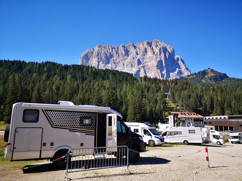
Day
Plan de Gralba
Streda Plan de Gralba 21, Sëlva - Wolkenstein - Selva di Val Gardena, South Tyrol, Trentino-Alto Adige/Südtirol, Italy
46° 31' 58.2" N 11° 46' 24.2" E
46.5328465 11.7733758
• Head southeast on Strada Plan de Gralba (SS242). Go for 5.3 km.
• Turn sharp right. Go for 187 m.
• Arrive at your destination on the left.
☍
5,5 km
( 7 min.)
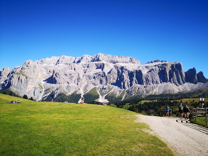
Day
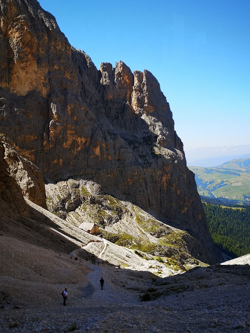
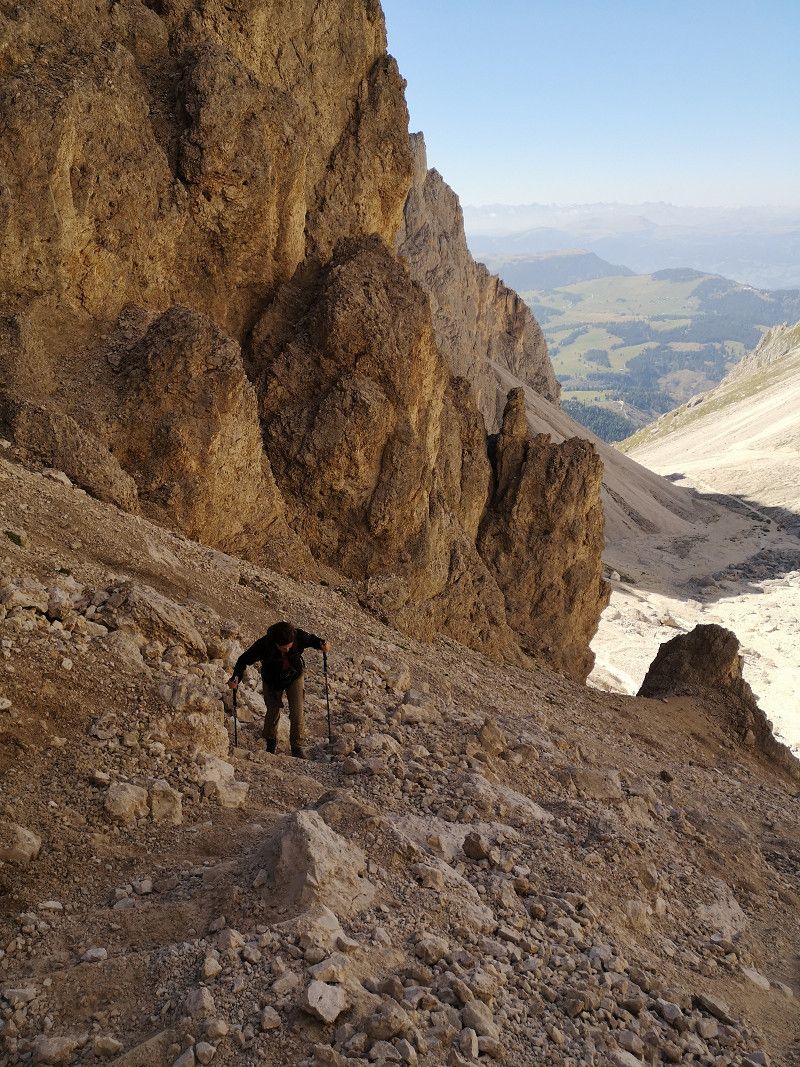
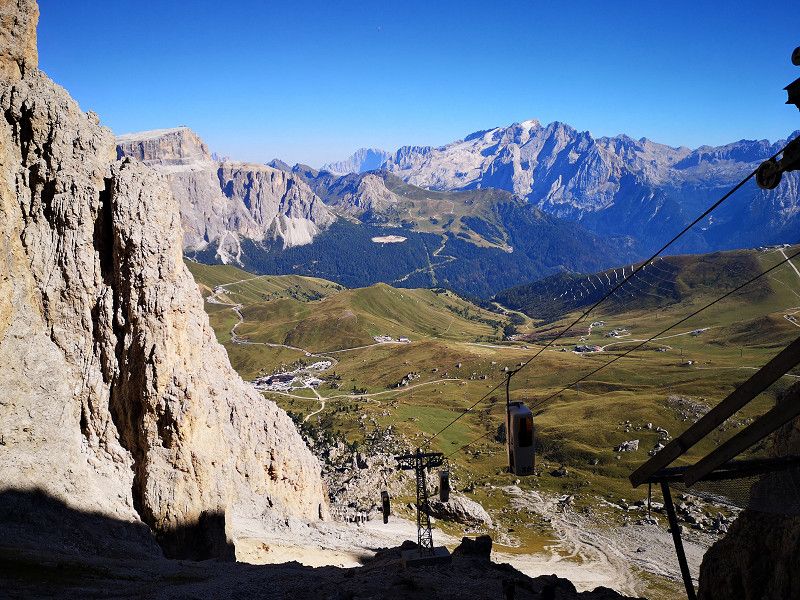
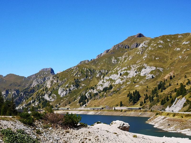
Sellajoch Paß
Sentiero Giro del Sasso Lungo, Sëlva - Wolkenstein - Selva di Val Gardena, South Tyrol, Trentino-Alto Adige/Südtirol, Italy
46° 30' 24" N 11° 45' 26.9" E
46.5066735 11.7574829
• Head north. Go for 187 m.
• Turn right onto Strada Passo Sella (SS242). Go for 6.3 km.
• Turn right onto Strada Statale delle Dolomiti (SS48) toward Modena/A22/Canazei. Go for 5.1 km.
• Turn left onto Streda de Col De Pin. Go for 444 m.
• Take the 2nd exit from roundabout onto Streda de Parèda (SS641) toward Alba-Penia/Rocca Pietore/Cortina/Belluno. Go for 10.7 km.
• Turn right onto Località Fedaia. Go for 145 m.
• Turn right onto Località Fedaia. Go for 726 m.
• Arrive at Località Fedaia.
☍
23,6 km
( 33 min.)
Day
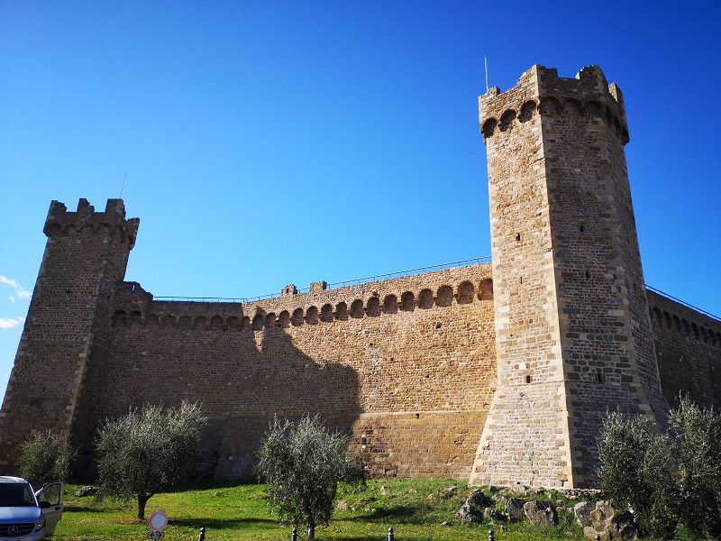
Lago di Fedaia
Provincia di Trento, Trentino-Alto Adige/Südtirol, Italy
46° 27' 30.8" N 11° 51' 56.4" E
46.4585499 11.8656566
• Head east on Località Fedaia. Go for 1.8 km.
• Continue on Località Passo Fedaia. Go for 12.8 km.
• Continue on Località Saviner di Laste (SP563) toward Belluno/Agordo/Alleghe/Caprile. Go for 1.2 km.
• Continue on Corso Veneto (SR203) toward Belluno/Agordo. Go for 13.0 km.
• Turn right onto Piazza 4 Novembre (SP346) toward Autostrade/A22/Bolzano/Falcade/Canale d'a./Vallada A./S. Tomaso. Go for 12.8 km.
• Turn right onto Strada Provinciale del Passo di San Pellegrino (SP346). Go for 3.3 km.
• Continue on Strada Statale del Passo di San Pellegrino (SS346). Go for 13.2 km.
• Take the 1st exit from roundabout onto SS48 toward Autostrada/A22/Trento/Predazzo. Go for 2.0 km.
• Pass 4 roundabouts and continue on Strada Statale delle Dolomiti (SS48). Go for 9.7 km.
• Take the 1st exit from roundabout onto Strada Provinciale di Fiemme (SP232) toward Cavalese/Trento/SS12/A22/Ora/SS48. Go for 5.2 km.
• Take the 2nd exit from roundabout onto Strada Provinciale di Fiemme (SP232) toward Brennero/A22/Modena/Cavalese/SS252/Trento/SS48. Go for 6.4 km.
• Take the 3rd exit from roundabout onto Strada Provinciale di Fiemme (SP232) toward Autostrada/A22. Go for 3.2 km.
• Continue on Strada Statale delle Dolomiti (SS48). Go for 16.4 km.
• Turn slightly left onto Via Egna (SP17) toward Gleno/Glen/Centro/Zentrum. Go for 2.9 km.
• Turn right onto Via Villa (SP84). Go for 899 m.
• Continue on Strada Provinciale Autostrada-Termeno (SP16) toward Autobahn/Autostrada/A22. Go for 140 m.
• Take the 2nd exit from roundabout toward Autostrada/A22/Autobahn. Go for 273 m.
• Turn right onto Strada Provinciale Autostrada-Termeno (SP16). Go for 257 m.
• Take the 1st exit from roundabout onto A22 (Autostrada del Brennero) toward Autostrada/Autobahn/Modena/Trento. Go for 65.6 km.
• Take the exit toward Rovereto Sud/Lago di Garda Nord. Go for 1.3 km.
• Take the 4th exit from roundabout toward Mori/Riva D/G/Arco. Go for 297 m.
• Continue on SS240. Go for 6.2 km.
• Pass 2 roundabouts and continue on Strada Rivana (SS240). Go for 5.1 km.
• Take the 3rd exit from roundabout onto Località Dosse (SS240dir) toward Arco. Go for 4.9 km.
• Take the 2nd exit from roundabout onto Viale Rovereto (SS240dir) toward Arco Centro. Go for 248 m.
• Take the 1st exit from roundabout onto Località Caneve (SS240dir). Go for 595 m.
• Take the 2nd exit from roundabout onto Strada Statale Gardesana Occidentale (SS45bis). Go for 592 m.
• Take the 2nd exit from roundabout onto Via San Pietro (SS45bis). Go for 364 m.
• Turn right onto Via Cesare Battisti (SP36) toward Ospedale/Ceole/Varignano/Vigne/Chiarano/Laghi. Go for 661 m.
• Turn right onto Via Francesco II di Borbone. Go for 228 m.
• Arrive at Via Francesco II di Borbone. Your destination is on the left.
☍
191,4 km
(2 hrs. 43 min.)
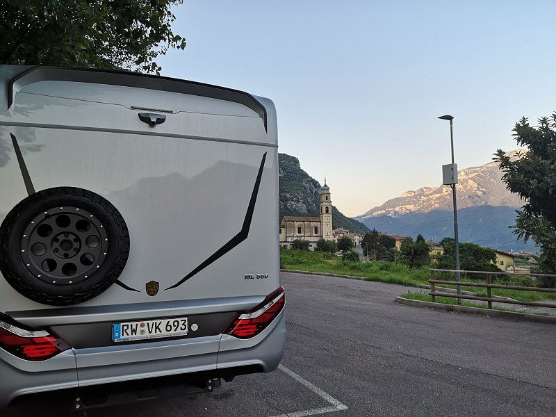
Day
Arco
Via Francesco II di Borbone 18, Arco, Provincia di Trento, Trentino-Alto Adige/Südtirol, Italy
45° 55' 14.5" N 10° 52' 37" E
45.9207058 10.8769397
• Head northeast on Via Francesco II di Borbone.
• Turn right toward Via Francesco II di Borbone. Go for 56 m.
• Turn right onto Via Francesco II di Borbone. Go for 228 m.
• Turn left onto Viale dei Capitelli (SP36). Go for 661 m.
• Continue on Via Garberie (SS45bis). Go for 315 m.
• Take the 2nd exit from roundabout onto Via Santa Caterina (SS45bis). Go for 794 m.
• Take the 3rd exit from roundabout onto Via Grande Circonvallazione toward Brennero/A22/Modena/Rovereto/SS240/Trento/SS45bis/Verona. Go for 617 m.
• Continue toward SP118. Go for 36 m.
• Take the 3rd exit from roundabout onto SP118 toward Autostrada/A22/Nago/SS240dir/Dro/SS45bis/Mori/SS240/Rovereto/Trento. Go for 1.6 km.
• Take the 1st exit from roundabout toward Nago/SS45bis/Rovereto. Go for 35 m.
• Turn right onto Strada Statale di Loppio e Val di Ledro (SS240dir). Go for 4.8 km.
• Take the 3rd exit from roundabout onto Strada Rivana (SS240) toward Autostrada/A22/Rovereto. Go for 676 m.
• Pass 2 roundabouts and continue on Località Loppio (SS240). Go for 10.7 km.
• Keep right toward Brennero/Modena. Go for 192 m.
• Take ramp onto A22 (Autostrada del Brennero) toward Modena/Verona. Go for 13.4 km.
• Take the exit toward Ala-Avio. Go for 776 m.
• Turn left onto Strada Provinciale Destra Adige (SP90) toward Sabbionara/Avio/Verona/Zona Industriale Avio. Go for 1.7 km.
• Take the 3rd exit from roundabout onto Via al Ponte. Go for 920 m.
• Take the 2nd exit from roundabout onto Via Generale Antonio Cantore toward Verona. Go for 336 m.
• Turn right onto Strada Statale dell'Abetone e del Brennero (SS12). Go for 10.3 km.
• Turn right toward Via Cantarane. Go for 68 m.
• Continue on Via Cantarane. Go for 322 m.
• Continue on Via del Ponte. Go for 311 m.
• Turn left onto SP11 toward Brentino B./Caprino V./SP8/Verona/SP12. Go for 110 m.
• Continue on Via Adige (SP11). Go for 304 m.
• Continue on SP11. Go for 9 m.
• Continue on Via Adige (SP11). Go for 968 m.
• Continue on SP11. Go for 2.1 km.
• Continue on Località Treminon (SP11). Go for 275 m.
• Turn right onto Località Treminon. Go for 299 m.
• Continue straight ahead. Go for 29 m.
• Arrive at your destination on the right.
☍
52,8 km
( 47 min.)
Punto Sosta
Via Santuario, 37020, Brentino Belluno, Italy
45° 37' 58" N 10° 52' 3" E
45.6327778 10.8675000
• Head southwest. Go for 222 m.
• Turn slightly right onto Località Treminon. Go for 106 m.
• Turn right onto SP11. Go for 826 m.
• Continue on Via Aldo Moro (SP11). Go for 34 m.
• Continue on SP11. Go for 1.5 km.
• Continue on Località Turan (SP11). Go for 397 m.
• Continue on SP11. Go for 165 m.
• Continue on Località Turan (SP11). Go for 223 m.
• Continue on SP11. Go for 3.8 km.
• Continue on Via Zuane Osteria (SP11). Go for 1.3 km.
• Turn left onto Via San Pieretto (SP11) toward Brennero-Modena/A22/Rivoli V.Se/Affi/Verona. Go for 1.3 km.
• Take the 2nd exit from roundabout onto Località Porton (SP11) toward Autostrada/A22/Affi/Verona. Go for 1.9 km.
• Continue on SP11. Go for 190 m.
• Continue on Dauzia (SP11). Go for 332 m.
• Continue on SP11. Go for 343 m.
• Turn right toward Via San Pieretto/SP29b. Go for 140 m.
• Continue on Via San Pieretto (SP29b). Go for 837 m.
• Take the 2nd exit from roundabout onto Via San Pieretto (SP29b). Go for 386 m.
• Continue toward Autostrada del Brennero/A22. Go for 53 m.
• Take the 4th exit from roundabout onto A22 (Autostrada del Brennero) toward Milano-Venezia/A4. Go for 106 km.
• Take the left exit toward Bologna/Roma/Modena onto A1 (Autostrada del Sole). Go for 51.7 km.
• Continue on SS64var. Go for 928 m.
• Continue on Raccordo Autostradale Sasso Marconi SS64 Porretana. Go for 2.4 km.
• Continue on A1 (Autostrada del Sole). Go for 10.7 km.
• Keep right onto A1var (Variante di Valico) toward Direttissima/A1/Firenze/Badia. Go for 37.7 km.
• Continue on A1 (Autostrada del Sole). Go for 16.5 km.
• Take the exit toward Calenzano/Sesto Fiorentino/Prato/Calenzano Centro. Go for 771 m.
• Keep right onto Via di Prato toward Calenzano Centro. Go for 269 m.
• Turn right onto Via Vittorio Emanuele toward Calenzano Centro. Go for 37 m.
• Continue on Via di Prato. Go for 198 m.
• Pass 3 roundabouts and continue on Via di Prato. Go for 1.3 km.
• Take the 3rd exit from roundabout onto Via di Prato. Go for 160 m.
• Take the 2nd exit from Via di Prato roundabout onto Via Firenze toward Prato. Go for 542 m.
• Pass 2 roundabouts and continue on Via Firenze (SP8). Go for 2.2 km.
• Turn right onto Via Firenze. Go for 125 m.
• Keep left onto Via Firenze. Go for 100 m.
• Turn right onto Via Firenze. Go for 992 m.
• Take the 2nd exit from Rotatoria della Stazione roundabout onto Via Giacomo Matteotti. Go for 182 m.
• Turn left onto Via Giacomo Matteotti. Go for 150 m.
• Take the 2nd exit from roundabout onto Ponte 20 Settembre. Go for 71 m.
• Continue on Via Arcivescovo Antonio Martini. Go for 281 m.
• Arrive at Via Arcivescovo Antonio Martini. Your destination is on the right.
☍
247,7 km
(2 hrs. 19 min.)
Day
Prato
Italien
43° 52' 39.7" N 11° 6' 8" E
43.8777049 11.1022280
• Head southwest on Via Arcivescovo Antonio Martini.
• Continue on Via Pomeria. Go for 853 m.
• Continue on Via Giovacchino Carradori. Go for 232 m.
• Continue on Via Camillo Benso di Cavour. Go for 324 m.
• Take the 2nd exit from Rotatoria dell'Ospedale roundabout onto Via Jean Monnet. Go for 554 m.
• Take the 2nd exit from Rotatoria Jean Monnet roundabout onto Via Pietro Nenni. Go for 337 m.
• Take the 1st exit from Rotatoria Pietro Nenni roundabout onto Strada Provinciale Autostrada Declassata (SP6) toward Autostrada/Pistoia/Poggio a Caiano. Go for 1.4 km.
• Take ramp toward Vaiano-Vernio/Montemurlo/Zona Industriale Macrolotto. Go for 209 m.
• Take the 3rd exit from Rotatoria di Capezzana roundabout onto Viale Salvador Allende toward Poggio a Caiano/Zona Industriale Macrolotto. Go for 795 m.
• Take the 2nd exit from roundabout onto Viale Salvador Allende. Go for 582 m.
• Take the 2nd exit from roundabout onto Viale 16 Aprile. Go for 704 m.
• Pass 5 roundabouts. Go for 3.9 km.
• Take the 1st exit from roundabout onto Via Statale (SR66). Go for 565 m.
• Take the 3rd exit from roundabout onto Via Baccheretana. Go for 1.0 km.
• Turn left onto Via Pistoiese. Go for 2.4 km.
• Continue on Via Pucci Verdini. Go for 304 m.
• Turn right onto Largo della Repubblica (SP43). Go for 31 m.
• Continue on Piazza Vittorio Emanuele II (SP43). Go for 127 m.
• Continue on Via Jacopo Modesti (SP43). Go for 176 m.
• Continue on Piazza Santi Michele e Francesco (SP43). Go for 46 m.
• Continue on Via Vergheretana (SP43). Go for 1.5 km.
• Continue on SP43. Go for 62 m.
• Continue on Via Vergheretana (SP43). Go for 1.9 km.
• Continue on Via Montalbano (SP43). Go for 1.8 km.
• Continue on Passo del Pinone (SP43). Go for 74 m.
• Continue on SP43. Go for 1.2 km.
• Continue on Via Carmignanese (SP43). Go for 5.0 km.
• Turn slightly right onto Via Amerini. Go for 1.6 km.
• Continue on Via Ripalta. Go for 1.5 km.
• Turn left onto Via Girolamo Calvi. Go for 99 m.
• Arrive at Via Girolamo Calvi. Your destination is on the right.
☍
29,3 km
( 37 min.)
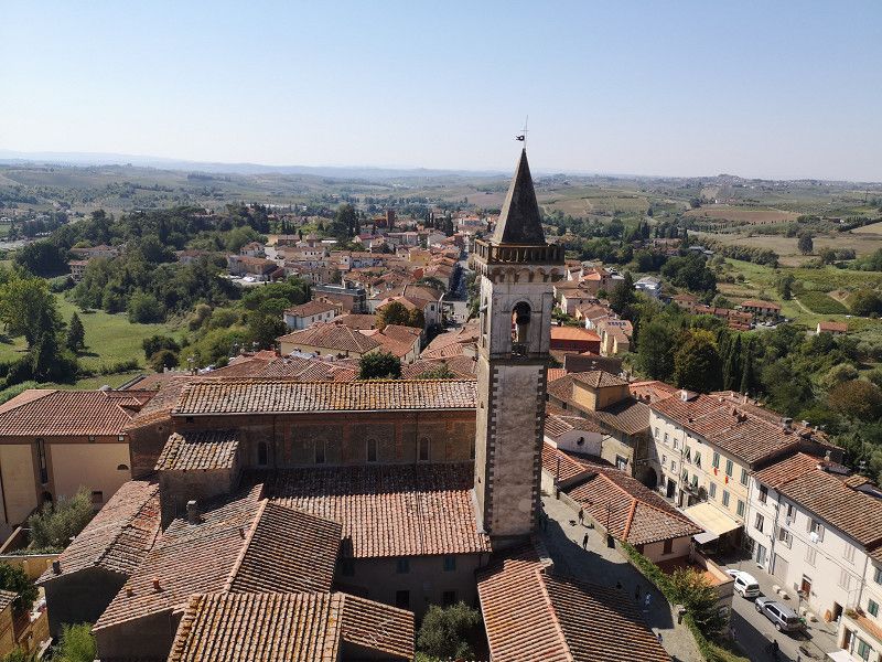
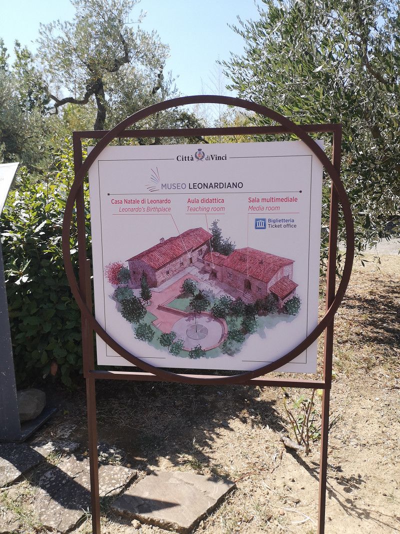
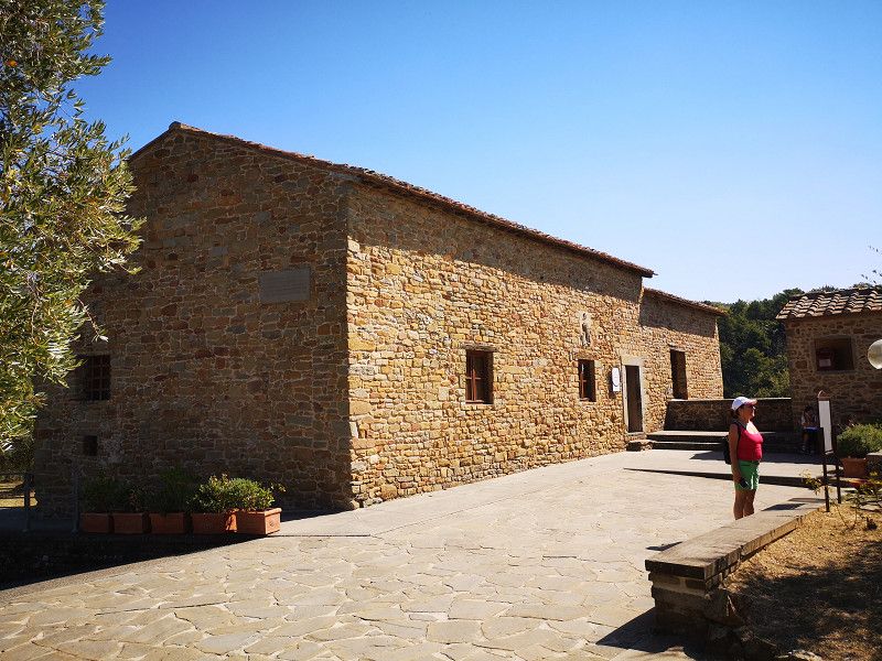
Day
Vinci
Birthplace of Leonardo da Vinci, an all-rounder. The two museums are worth seeing, but the birthplace is not necessarily.
Parking space with water and wastewater, 5 minutes to the center, free and partial shade until around 2 p.m.
Via Girolamo Calvi 74, Vinci, Firenze, Italy
43° 46' 53.3" N 10° 55' 42" E
43.7814672 10.9283339
• Head toward Via Piagge on Via Girolamo Calvi. Go for 342 m.
• Continue on Via Giacomo Matteotti. Go for 126 m.
• Turn slightly left onto Via Cerretana (SP105). Go for 663 m.
• Take the 2nd exit from roundabout onto Via Cerretana (SP105) toward Cerreto Guidi/Toiano/Apparita. Go for 4.2 km.
• Turn right onto Via Pianello Val Tidone (SP31). Go for 3.1 km.
• Turn left onto Via sul Vincio (SP31). Go for 2.1 km.
• Turn left onto Via Mario Bercilli. Go for 404 m.
• Turn left onto Via Provinciale Francesca (SR436). Go for 985 m.
• Turn right onto Via di Massarella (SP111) toward Massarella/Chiesina Uz. Go for 7.2 km.
• Continue toward SP111. Go for 20 m.
• Turn right onto Via Pesciatina (SP60) toward Chiesina Uzzanese. Go for 4.0 km.
• Turn right onto Via Valdinievole (SP15). Go for 179 m.
• Turn left onto Strada Provinciale del Biagioni (SP36) toward Lucca/Altopascio. Go for 2.5 km.
• Take the 1st exit from roundabout onto Via della Sibolla. Go for 351 m.
• Take the 3rd exit from roundabout onto Via della Sibolla. Go for 650 m.
• Continue on Via delle Cerbaie. Go for 75 m.
• Take ramp onto A11 (Autostrada Firenze Mare) toward Firenze/Pisa/Pisa Nord/Aurelia/SS1. Go for 17.1 km.
• Take the exit toward Lucca Est onto Viale Europa. Go for 841 m.
• Keep right onto Viale Europa toward Pescia/SS435/Camaiore/SP1/Castelnuovo Garfagnana/SP2/Abetone. Go for 778 m.
• Keep right onto Viale Giosuè Carducci toward Pescia. Go for 952 m.
• Turn left onto Piazzale Bettino Ricasoli. Go for 78 m.
• Continue on Sortita Baluardo San Colombano. Go for 183 m.
• Turn left onto Rampa Baluardo San Colombano. Go for 91 m.
• Turn sharp right onto Corso Giuseppe Garibaldi. Go for 140 m.
• Turn left onto Piazza della Rosa. Go for 25 m.
• Continue on Via della Rosa. Go for 239 m.
• Continue on Piazza Santa Maria Forisportam. Go for 16 m.
• Turn left onto Via Santa Croce. Go for 202 m.
• Continue on Via Santa Croce. Go for 100 m.
• Continue on Via Roma. Go for 81 m.
• Continue on Piazza San Michele. Go for 28 m.
• Arrive at Piazza San Michele. Your destination is on the right.
☍
47,7 km
( 46 min.)
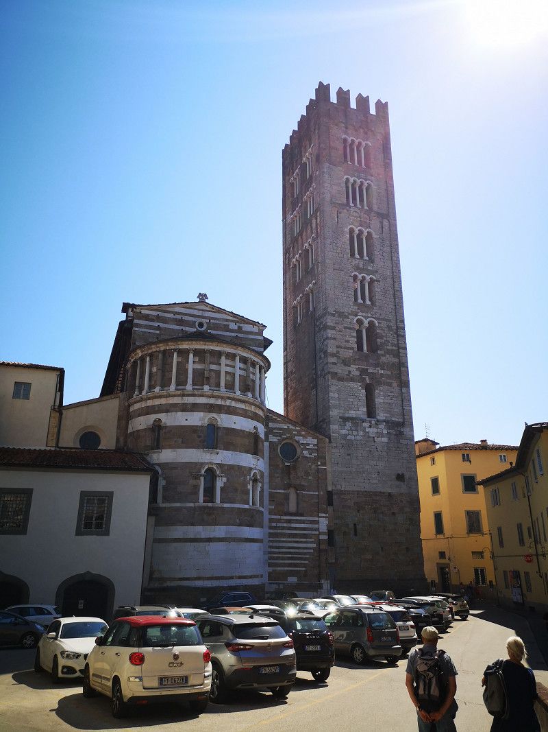
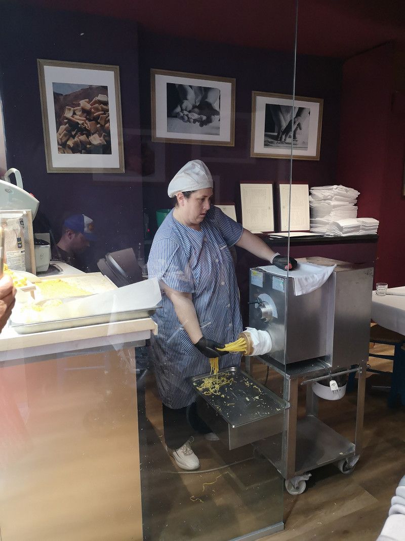
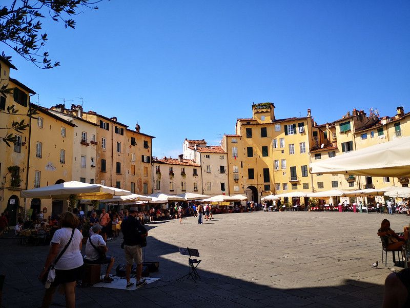
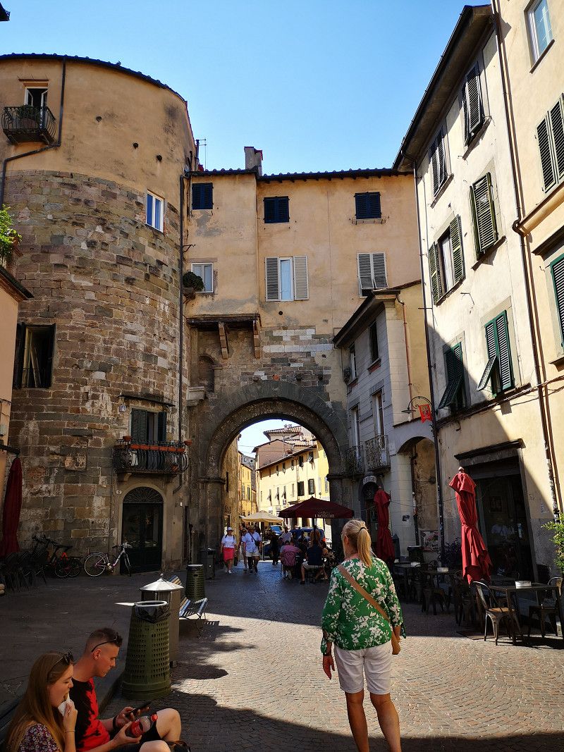
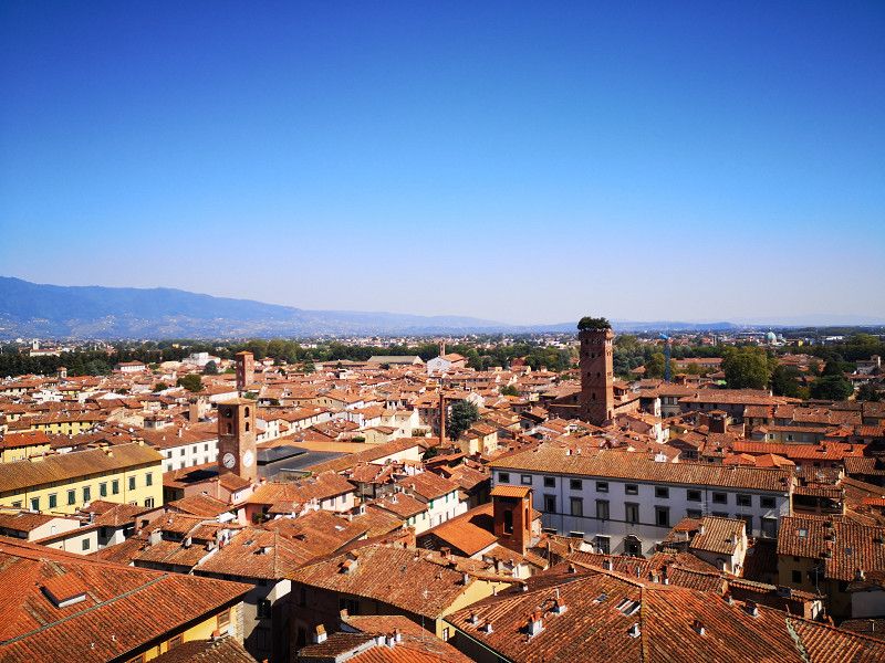
Day
Lucca, Italien
Very nice town to stay in
55100 Lucca, Italien
43° 50' 34.5" N 10° 30' 9.7" E
43.8429197 10.5026977
• Head west on Piazza San Michele. Go for 41 m.
• Turn left onto Via Vittorio Veneto. Go for 97 m.
• Turn left onto Piazza Napoleone. Go for 66 m.
• Turn right onto Piazza Napoleone. Go for 113 m.
• Continue on Via San Girolamo. Go for 160 m.
• Turn left onto Via Francesco Carrara. Go for 9 m.
• Turn right onto Sortita Porta San Pietro. Go for 91 m.
• Turn right onto Piazzale del Risorgimento. Go for 54 m.
• Turn right onto Viale della Repubblica. Go for 98 m.
• Keep right onto Viale Giosuè Carducci. Go for 548 m.
• Take the 3rd exit from roundabout onto Viale Europa. Go for 877 m.
• Turn right. Go for 221 m.
• Keep right toward Genova/A12/Viareggio/A11/E80/Sarzanese/SR439. Go for 1.4 km.
• Continue on Viadotto San Donato. Go for 502 m.
• Take ramp onto A11 (Diramazione Viareggio-Lucca) toward Viareggio/Genova. Go for 18.9 km.
• Take the exit toward Genova/E31/A15/Parma onto A12 (Autostrada Azzurra). Go for 26.8 km.
• Take the exit toward Carrara. Go for 646 m.
• Take the 2nd exit from roundabout onto Viale Galileo Galilei. Go for 1.0 km.
• Turn right onto Via Aurelia (SS1). Go for 1.4 km.
• Take the 3rd exit from roundabout onto Viale 20 Settembre toward Carrara. Go for 3.2 km.
• Continue on Via Roma. Go for 319 m.
• Turn right onto Via Don Giovanni Minzoni. Go for 225 m.
• Keep right onto Via Don Giovanni Minzoni. Go for 155 m.
• Take the 2nd exit from Via Don Giovanni Minzoni roundabout onto Via del Cavatore. Go for 665 m.
• Turn left onto Via Monterosso. Go for 48 m.
• Turn left. Go for 42 m.
• Arrive at your destination on the right.
☍
57,7 km
( 45 min.)
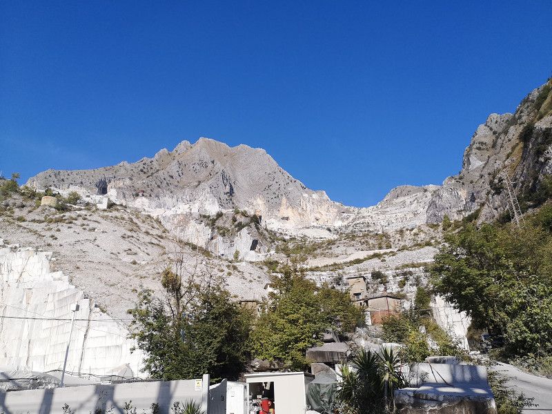
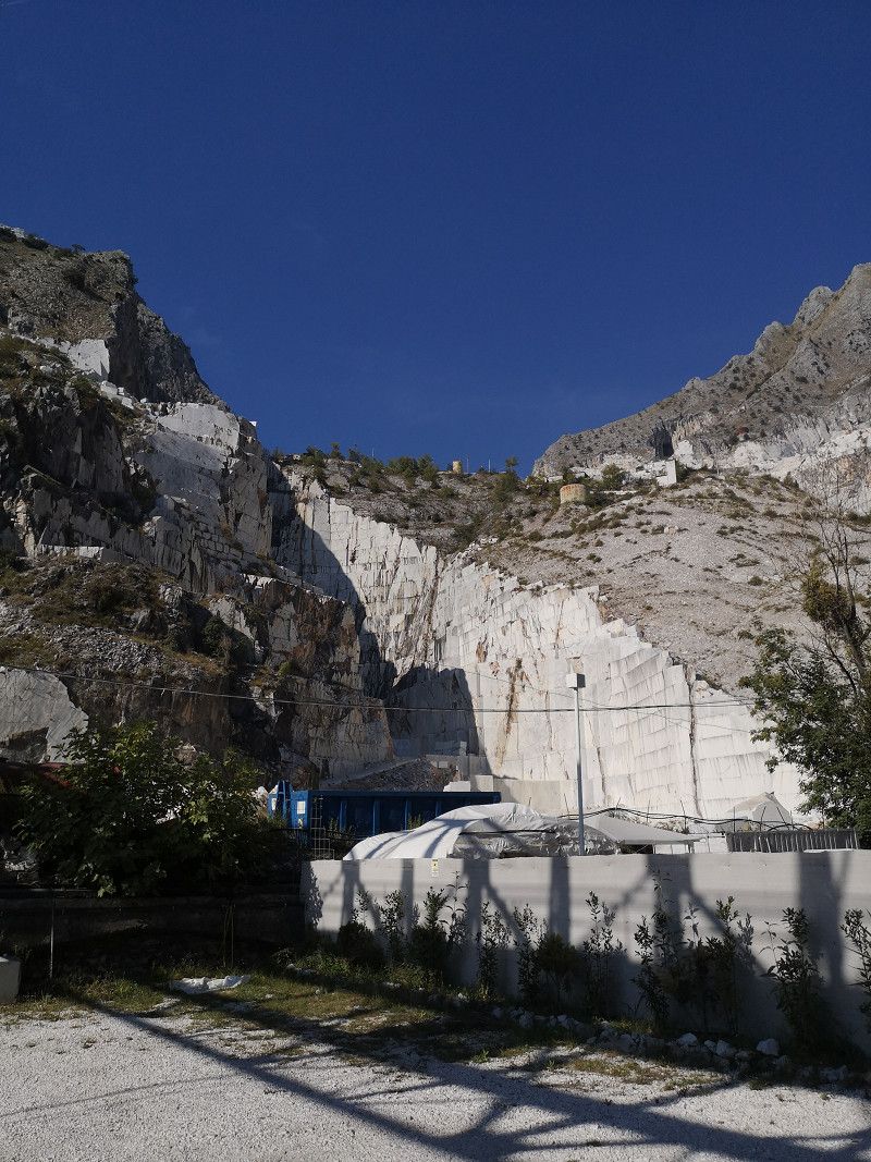
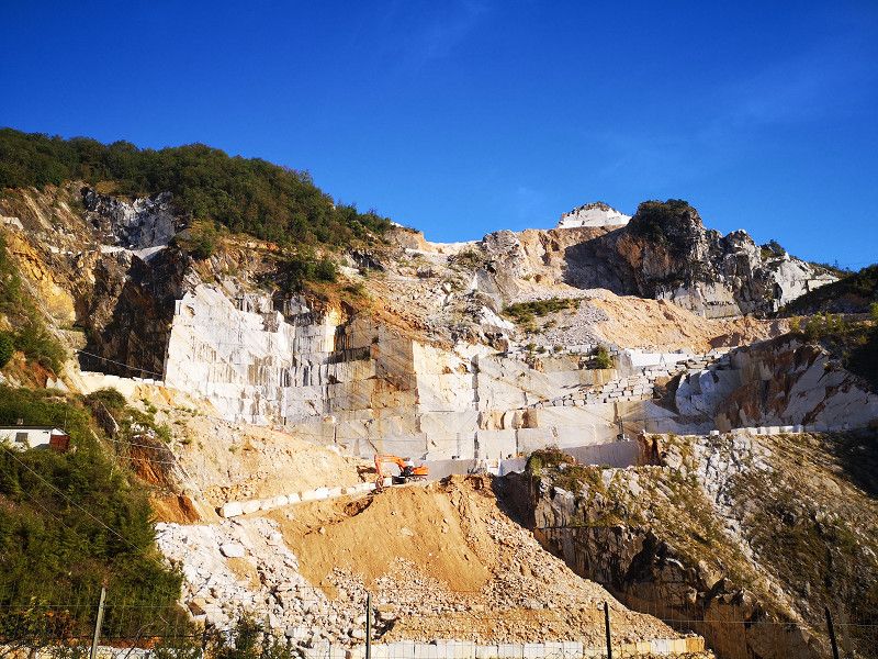
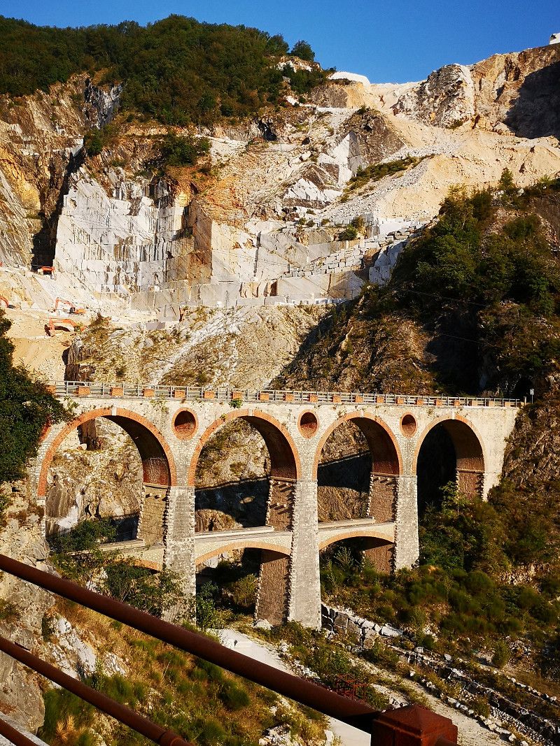
Carrara
It is best to book tours online
Massa-Carrara, Toskana, Italien
44° 4' 45" N 10° 6' 8.5" E
44.0791804 10.1023532
• Head toward Via del Cavatore. Go for 17 m.
• Turn left onto Via del Cavatore. Go for 62 m.
• Turn left onto Via Monterosso. Go for 77 m.
• Continue on Via Eugenio Chiesa. Go for 39 m.
• Turn left onto Piazza Monzoni. Go for 126 m.
• Turn slightly right onto Via del Cavatore. Go for 189 m.
• Turn left onto Via Lorenzo Bartolini. Go for 199 m.
• Turn left onto Via San Francesco. Go for 5.3 km.
• Turn right onto Strada Provinciale di Fosdinovo Diramazione (SP446dir). Go for 427 m.
• Turn right onto Via Aurelia Ovest (SS1). Go for 804 m.
• Take the 3rd exit from roundabout onto Via Enrico Mattei toward Autostrada/A12/Marina di Massa. Go for 868 m.
• Pass 2 roundabouts and continue on Via Enrico Mattei (SP46). Go for 1.6 km.
• Take the 1st exit from roundabout onto Strada Provinciale Massa Avenza (SP3) toward Autostrada/A12/Avenza-Carrara/Sarzana. Go for 201 m.
• Take the 2nd exit from roundabout onto A12 (Autostrada Azzurra) toward Autostrada/Genova/Rosignano M. Go for 45.8 km.
• Take the exit toward Pisa Centro/Aeroporto Pisa onto Strada di Grande Comunicazione Fi-Pi-Li. Go for 8.3 km.
• Take ramp onto Via Giovanni Gronchi toward SS12/SS206/Firenze/Pisa. Go for 1.9 km.
• Take the 2nd exit from Rotonda Alcide De Gasperi roundabout onto Via San Pio da Pietrelcina. Go for 745 m.
• Take the 1st exit from Rotonda Caduti di San Quirico di Valleriana roundabout onto Via Monsignore Aristo Manghi. Go for 167 m.
• Take the 2nd exit from Rotonda Giulio Battistini roundabout onto Via Monsignore Aristo Manghi. Go for 554 m.
• Continue on Via di Cisanello. Go for 92 m.
• Take the 2nd exit from Rotatoria Caduti di Kindu roundabout onto Via Ferruccio Giovannini. Go for 1.3 km.
• Take the 2nd exit from Rotatoria Caduti di Nassirya roundabout onto Via Giuseppe Moruzzi. Go for 642 m.
• Take the 2nd exit from roundabout onto Via di Pratale. Go for 126 m.
• Turn right onto Via di Pratale. Go for 73 m.
• Arrive at your destination on the right.
☍
69,5 km
( 55 min.)
Day
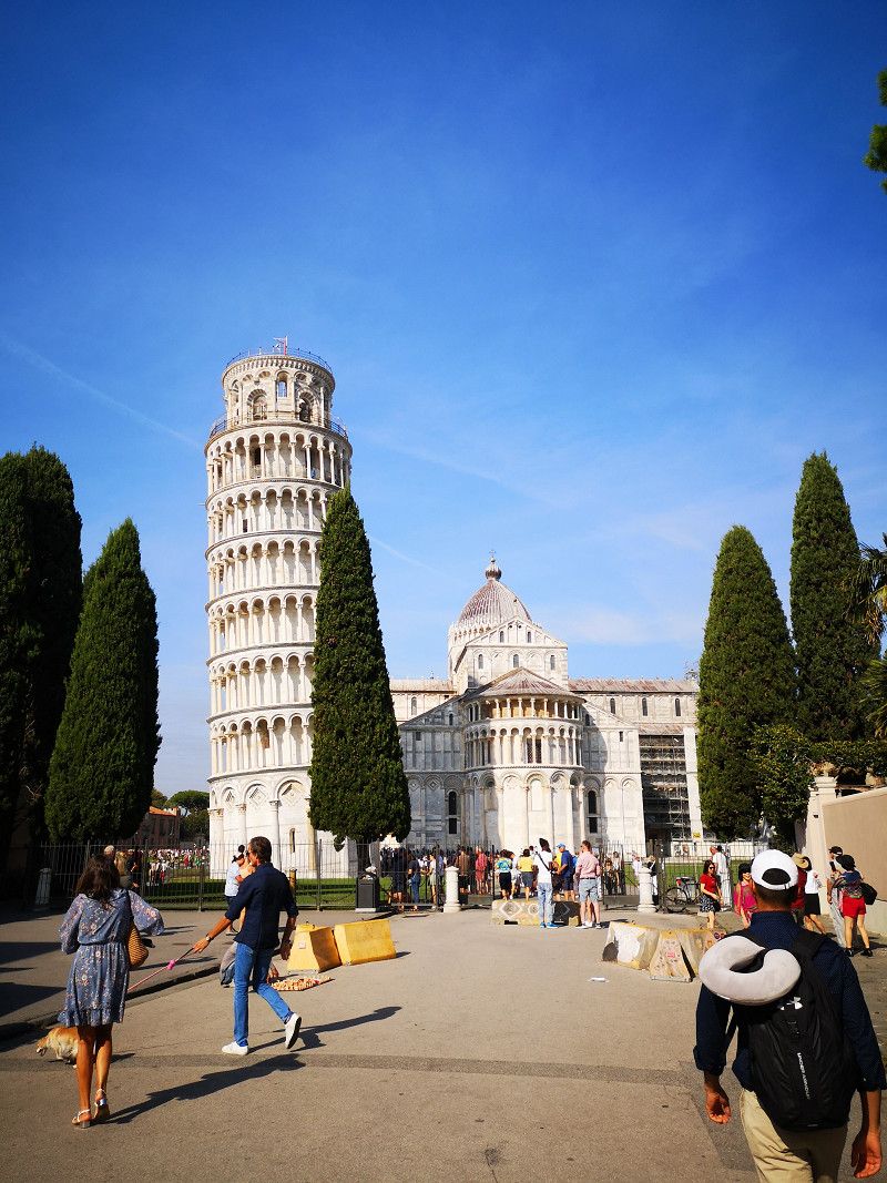
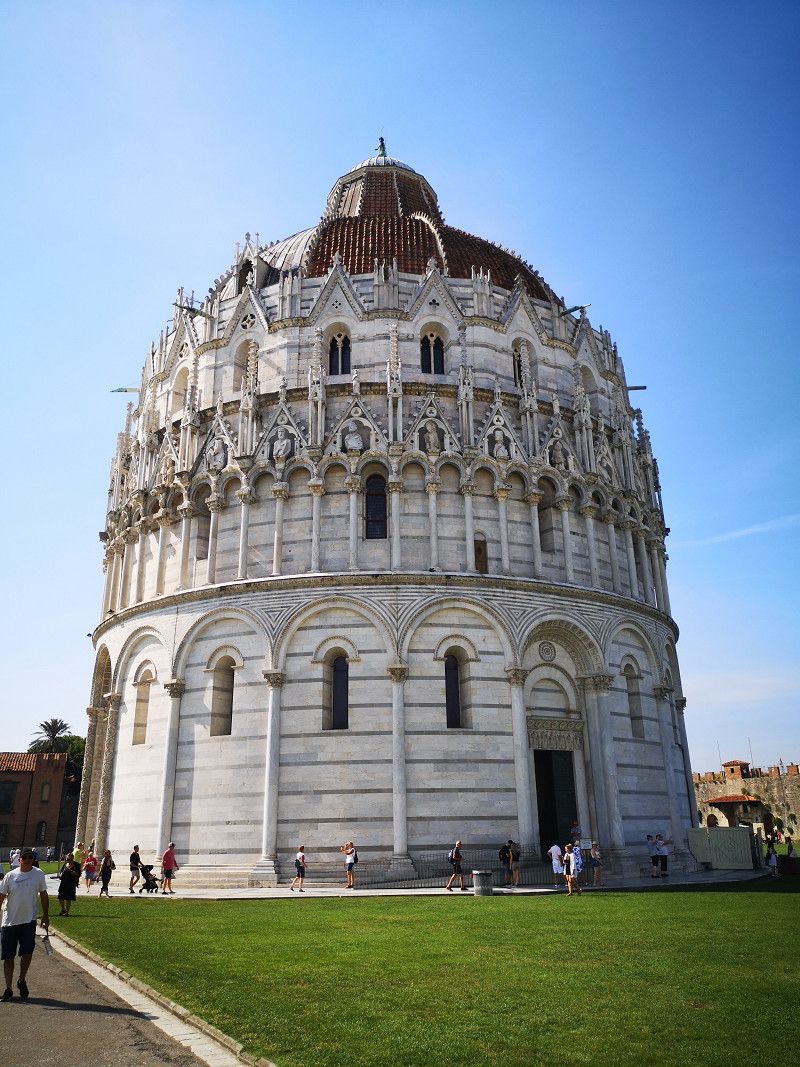
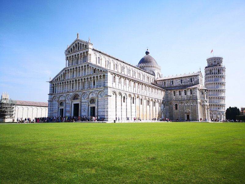
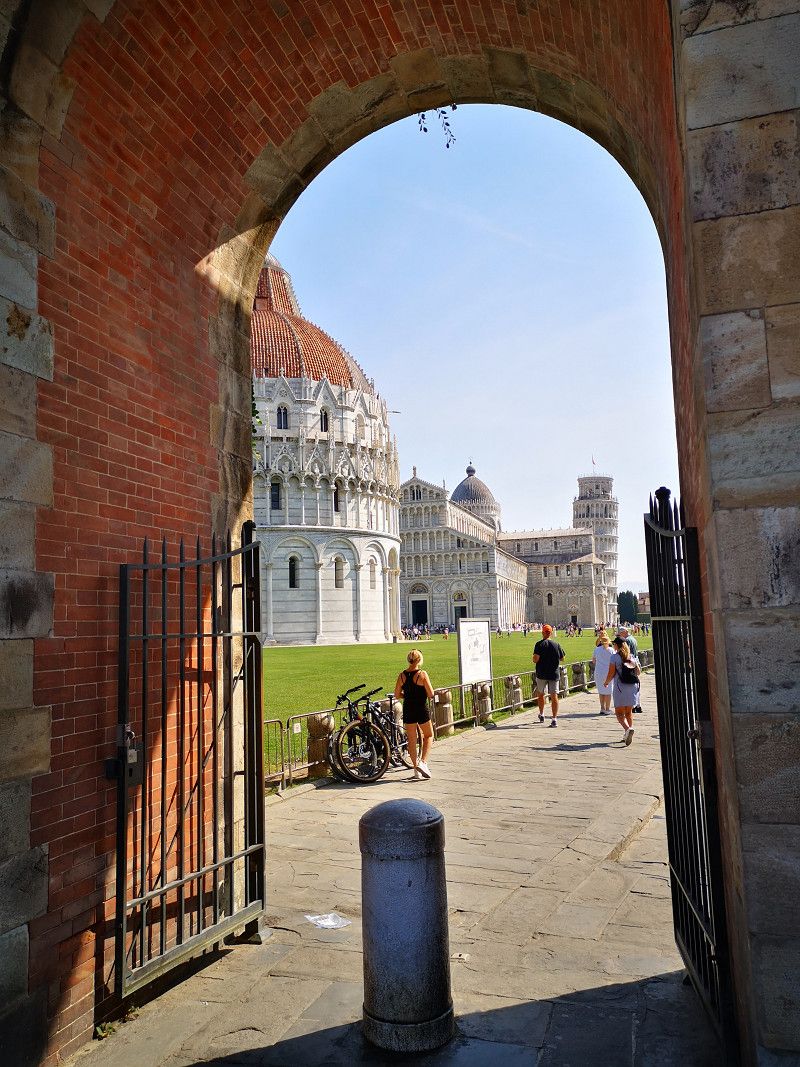
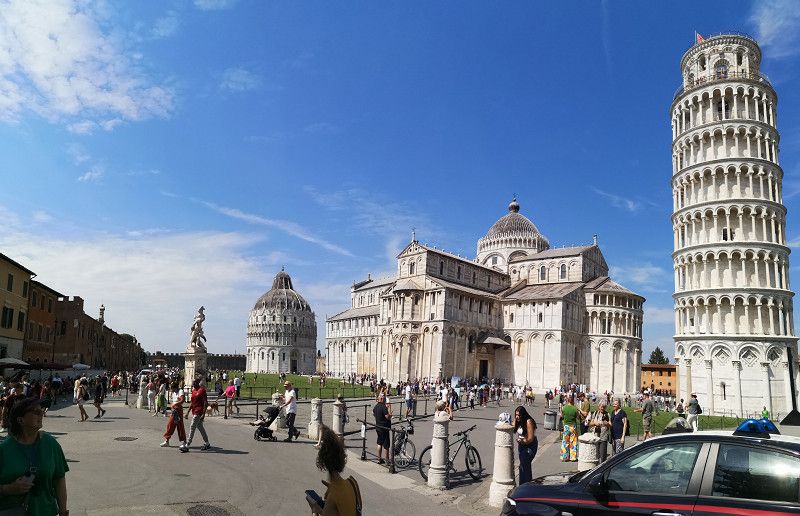
Pisa
Motorhome parking partly with electricity, very nice staff.
Via di Pratale, Pisa, Pisa, Tuscany, Italy
43° 43' 17.6" N 10° 25' 14.9" E
43.7215663 10.4207951
• Head northwest. Go for 270 m.
• Turn right toward Via di Pratale. Go for 14 m.
• Turn right onto Via di Pratale. Go for 200 m.
• Turn left onto Via Carlo Goldoni. Go for 216 m.
• Continue on Via Ignazio Pellegrini. Go for 58 m.
• Turn left onto Via San Giovanni Bosco. Go for 78 m.
• Keep right onto Via Enrico van Lint. Go for 97 m.
• Take the 2nd exit from Largo Gabriele Monasterio roundabout onto Via Gino Luzzatto toward Livorno/A12/Firenze/SP206/Roma. Go for 531 m.
• Continue on Via Pietro Nenni. Go for 435 m.
• Take the 2nd exit from roundabout onto Via Carlo Matteucci. Go for 262 m.
• Continue on Via Cisanello. Go for 375 m.
• Take the 2nd exit from Rotonda dell'Origine del Santo Sepolcro roundabout onto Via Cisanello. Go for 702 m.
• Take the 1st exit from Rotonda Caduti di San Quirico di Valleriana roundabout onto Via San Pio da Pietrelcina. Go for 673 m.
• Take the 1st exit from Rotonda Alcide De Gasperi roundabout onto Via Giovanni Gronchi. Go for 918 m.
• Take ramp onto Strada di Grande Comunicazione Fi-Pi-Li toward Firenze/Aurelia/SS1/Aeroporto/Autostrade/A11/A12. Go for 13.6 km.
• Take left ramp onto Strada di Grande Comunicazione Fi-Pi-Li toward Firenze. Go for 31.5 km.
• Take ramp toward Empoli. Go for 306 m.
• Take the 2nd exit from roundabout onto Circonvallazione Sud. Go for 2.0 km.
• Take the 3rd exit from roundabout. Go for 147 m.
• Take the 2nd exit from Via Luigi Pirandello roundabout onto Via Luigi Pirandello. Go for 133 m.
• Turn right onto Via Giambattista Vico. Go for 647 m.
• Keep left toward Montespertoli. Go for 38 m.
• Take the 2nd exit from roundabout onto Strada Provinciale di Val d'Orme (SP51) toward Siena/Castelfiorentino/Montespertoli/Martignana/Pozzale. Go for 653 m.
• Take the 3rd exit from roundabout onto Strada Provinciale di Val d'Orme (SP51) toward Siena/Castelfiorentino/Montespertoli. Go for 2.9 km.
• Continue on Via Val d'Orme (SP51). Go for 2.0 km.
• Pass 5 roundabouts and continue on Via Orme (SP51). Go for 5.5 km.
• Take the 1st exit from roundabout onto Strada Provinciale Volterrana (SP4). Go for 329 m.
• Arrive at Strada Provinciale Volterrana (SP4). Your destination is on the right.
☍
64,5 km
( 55 min.)
Ortimino
Florenz, Italien
43° 38' 14.7" N 11° 1' 28.6" E
43.6374267 11.0246160
• Head southwest on Strada Provinciale Volterrana (SP4). Go for 6.2 km.
• Continue on Via Giordano Bruno (SP4). Go for 1.2 km.
• Turn right toward Certaldo/Poggibonsi. Go for 170 m.
• Turn left toward Via Bernardino Ciurini/SR429. Go for 137 m.
• Continue on Via Bernardino Ciurini (SR429). Go for 906 m.
• Take the 2nd exit from roundabout onto Via Bernardo Ciurini (SR429) toward Siena/Certaldo. Go for 3.6 km.
• Turn left toward Certaldo Centro. Go for 48 m.
• Continue on Via delle Regioni. Go for 1.9 km.
• Continue on Via Fratelli Cervi. Go for 116 m.
• Take the 2nd exit from roundabout onto Via Fratelli Cervi toward Centro. Go for 493 m.
• Continue on Via Felice Cavallotti. Go for 227 m.
• Turn left onto Via Roberto Ruffilli. Go for 133 m.
• Turn right onto Via Giovanni Amendola. Go for 137 m.
• Turn slightly left onto Via Sallustio. Go for 106 m.
• Turn left onto Via delle Mura. Go for 972 m.
• Turn right onto Via delle Mura. Go for 475 m.
• Arrive at Via delle Mura. Your destination is on the left.
☍
16,8 km
( 22 min.)
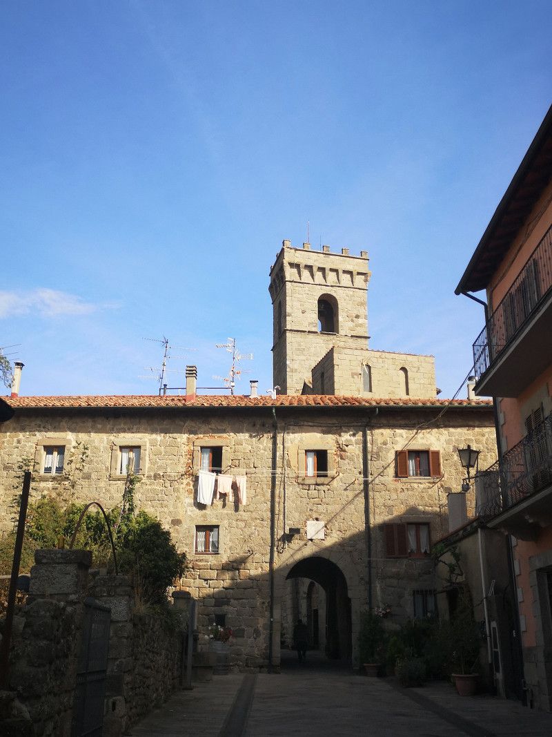
Day
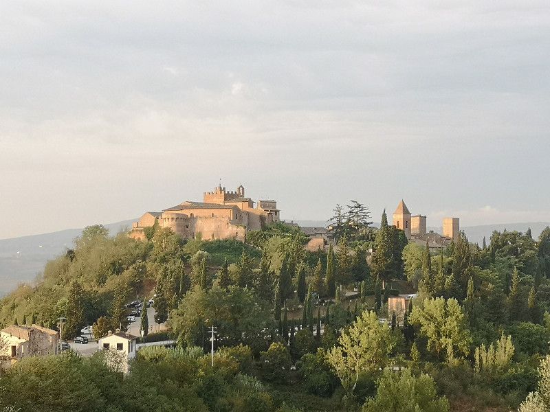
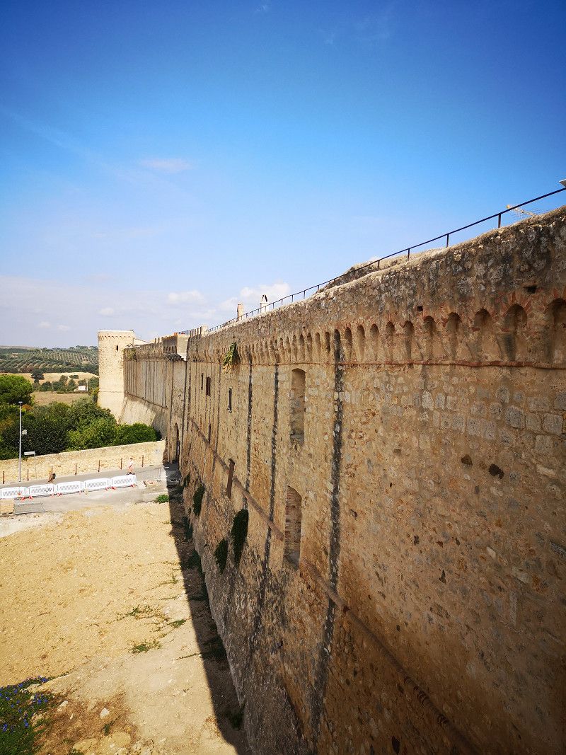
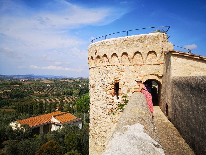
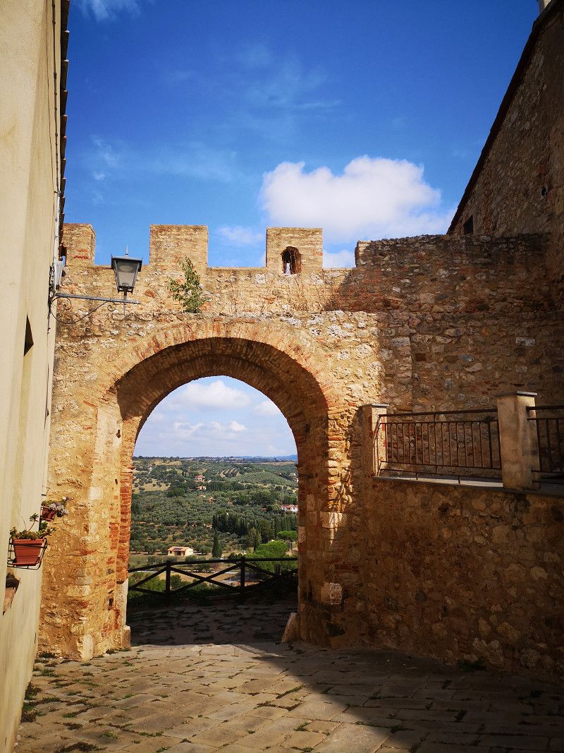
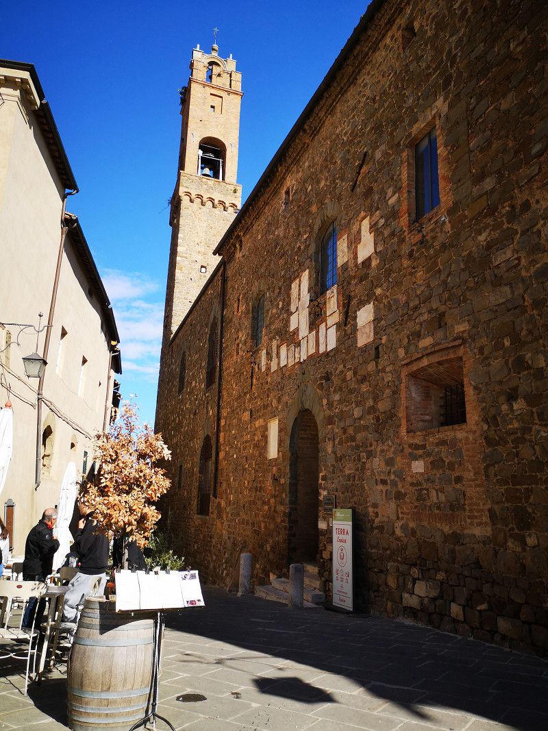
Certaldo Alto
Very nice old town on the mountain.
We stayed near a winery with a great view
Via delle Mura, Certaldo, Florence, Tuscany, Italy
43° 33' 11.7" N 11° 2' 53.1" E
43.5532398 11.0480697
• Head toward Località Quercitella Santa Maria a Collina on Via delle Mura. Go for 475 m.
• Turn sharp left onto Via delle Mura. Go for 972 m.
• Turn right onto Via Sallustio. Go for 106 m.
• Turn left onto Via del Bosco. Go for 129 m.
• Turn right onto Via Felice Cavallotti. Go for 20 m.
• Turn left onto Via Vincenzo Bellini toward Poggibonsi. Go for 148 m.
• Turn left onto Viale Giacomo Matteotti. Go for 57 m.
• Turn sharp right onto Via Fonda. Go for 206 m.
• Turn left onto Via Antonio Vivaldi. Go for 468 m.
• Take the 2nd exit from roundabout onto Via Giovanni Falcone e Paolo Borsellino toward San Gimignano/SP429/Gambassi Terme/Poggibonsi. Go for 185 m.
• Continue on Via Luigi Galvani. Go for 218 m.
• Continue on Via Marco Polo. Go for 229 m.
• Take the 1st exit from roundabout onto Strada Provinciale Certaldese 2 (SP64) toward Poggibonsi. Go for 146 m.
• Turn left onto Via dei Platani (SP1). Go for 518 m.
• Turn right onto Strada Provinciale di San Gimignano (SP1) toward Badia a Elmi. Go for 1.3 km.
• Turn right onto Via Fonte Campaino (SP1) toward S. Gimignano. Go for 8.8 km.
• Take the 3rd exit from roundabout onto Via Martiri di Citerna (SP1) toward Colle Val d'Elsa/Poggibonsi/Siena-Firenze. Go for 2.0 km.
• Turn slightly left onto Via Quercecchio. Go for 61 m.
• Turn left onto Via Quercecchio. Go for 169 m.
• Turn left onto Via San Giovanni. Go for 9 m.
• Turn slightly left onto Via San Giovanni. Go for 17 m.
• Continue on Piazza Cisterna. Go for 32 m.
• Turn slightly left onto Via San Matteo. Go for 24 m.
• Arrive at Via San Matteo. Your destination is on the right.
☍
16,3 km
( 26 min.)
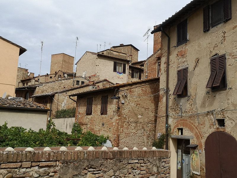
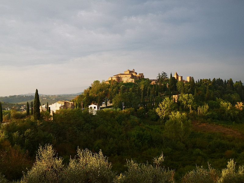
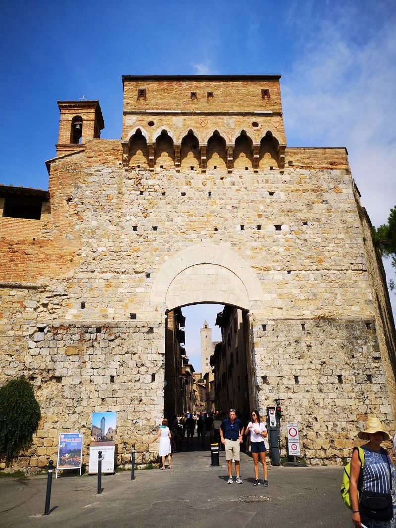
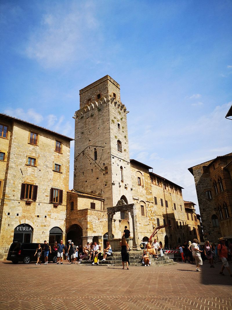
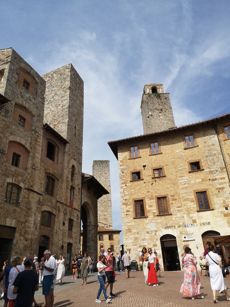
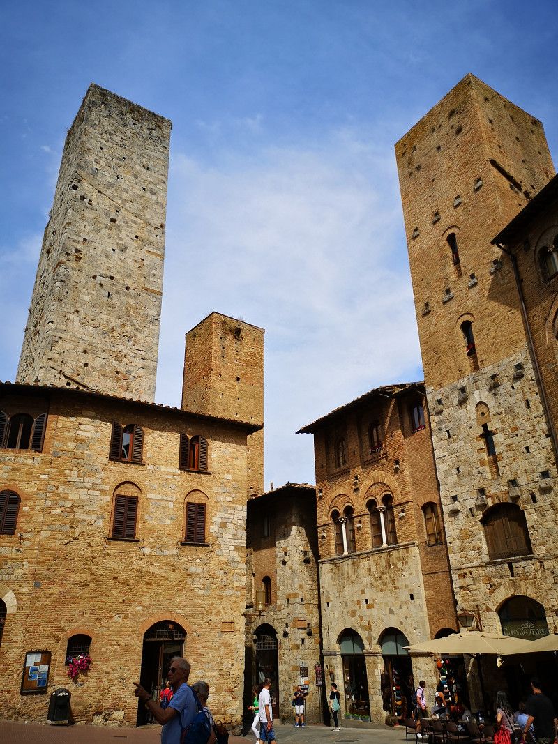
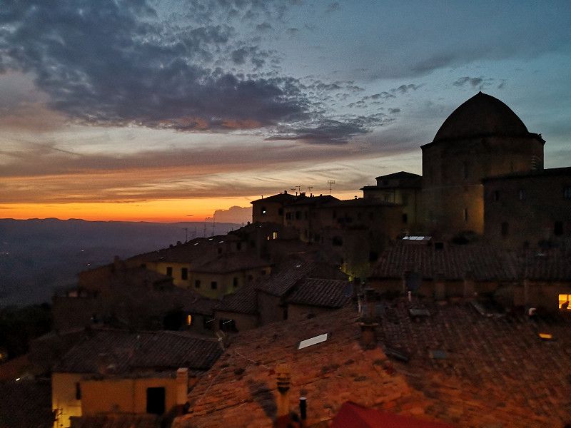
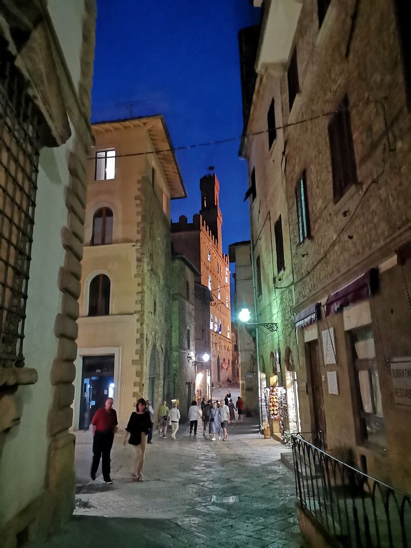
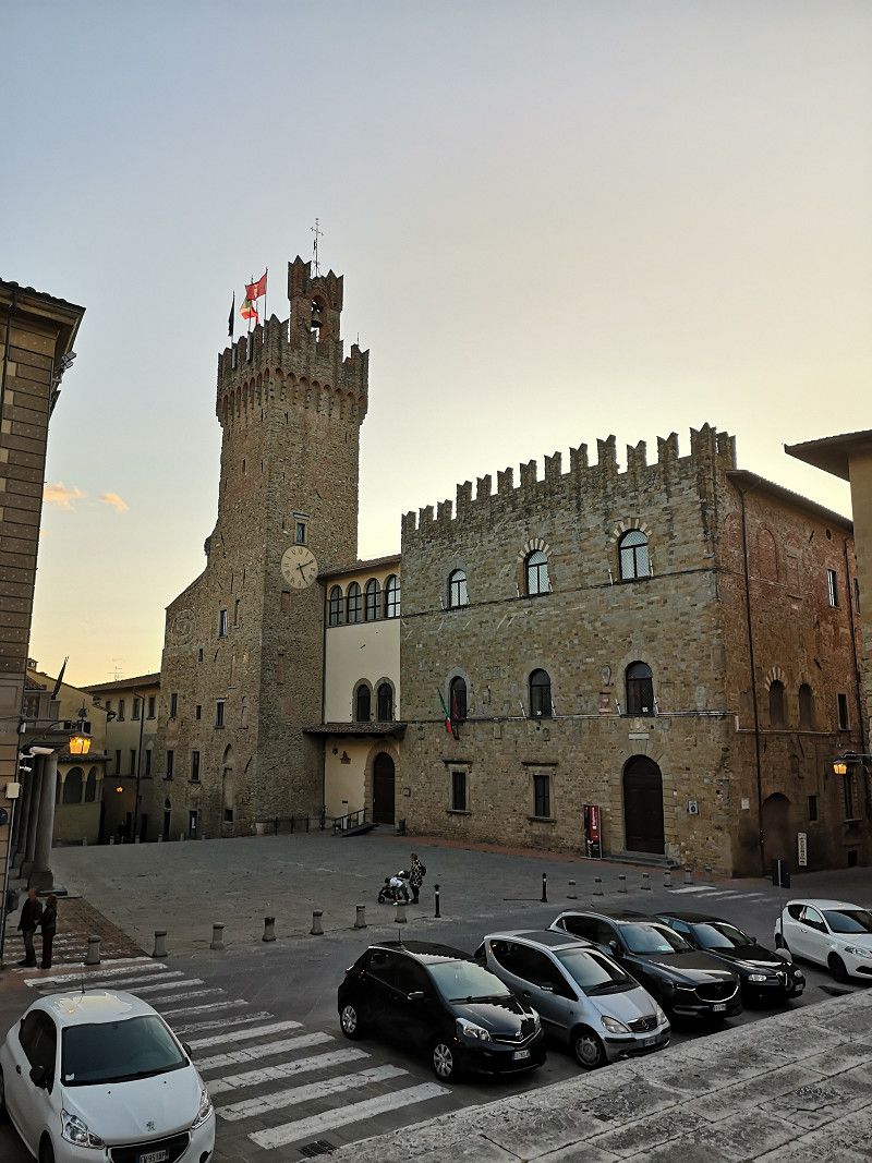
San Gimignano, Siena, Italien
An old town with a wow factor, like something out of a fairy tale. Unfortunately, very, very many tourists. There is an ice cream parlor in the central square that has won the world championship title several times.
53037 San Gimignano, Siena, Italien
43° 28' 3.5" N 11° 2' 36.6" E
43.4676324 11.0434909
• Head toward Piazza Duomo on Via San Matteo. Go for 345 m.
• Turn right onto Strada Provinciale di San Gimignano (SP1). Go for 1.6 km.
• Take the 2nd exit from roundabout onto Strada Provinciale di Cellole (SP69) toward Cellole Gambassi/Montaione/Gambassi/Larniano/Libbiano/Pancole. Go for 6.2 km.
• Continue on Strada Provinciale di S. Gimignano (SP63). Go for 645 m.
• Turn left onto Località Camporbiano (SP62) toward Volterra. Go for 3.6 km.
• Continue on Strada Provinciale del Cornocchio (SP53). Go for 6.7 km.
• Turn right onto Strada Regionale di Val di Cecina (SR68). Go for 8.3 km.
• Continue on Strada Regionale di Val di Cecina (SR68). Go for 3.1 km.
• Turn right onto Viale dei Ponti. Go for 43 m.
• Turn sharp right onto Via di Porta a Selci. Go for 68 m.
• Arrive at Via di Porta a Selci. Your destination is on the left.
☍
30,6 km
( 37 min.)
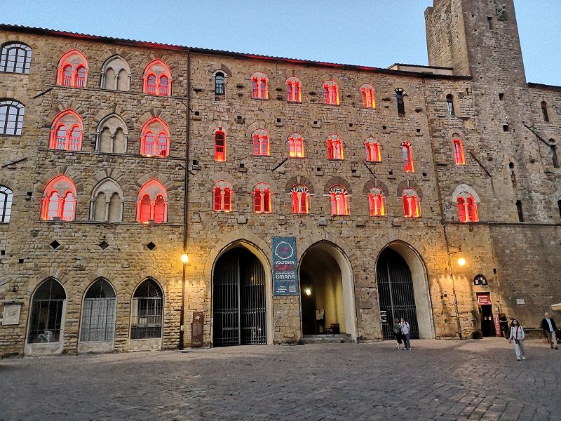
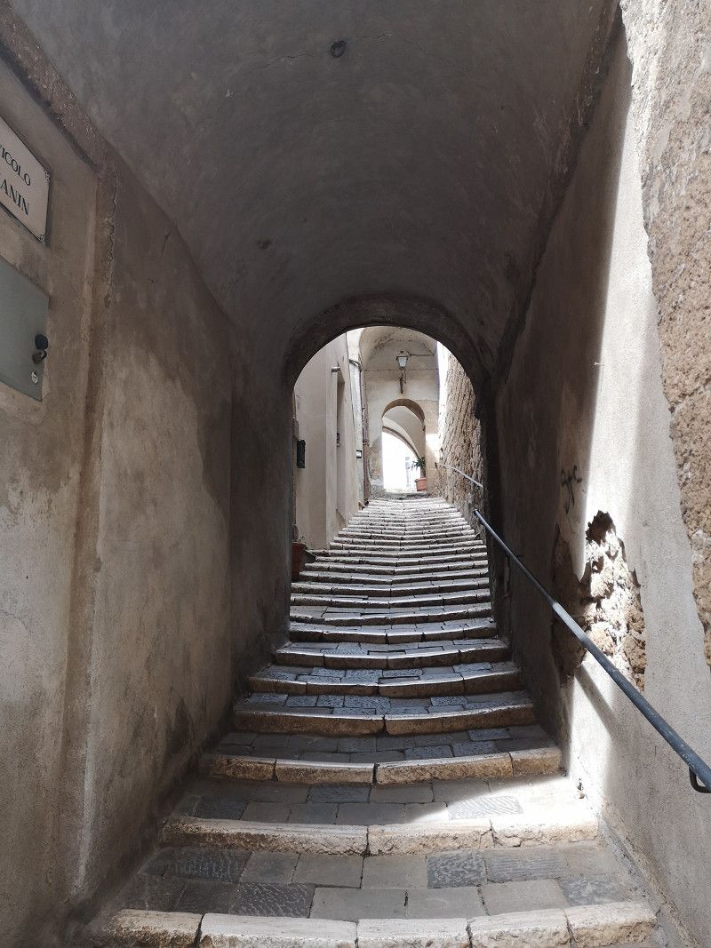
Volterra, Pisa, Italien
Motorhome parking space is located below the very beautiful old town, accessible via stairs with around 250 steps
56048 Volterra, Pisa, Italien
43° 23' 57.8" N 10° 51' 57.7" E
43.3993950 10.8660333
• Head toward Viale dei Ponti on Via di Porta a Selci. Go for 68 m.
• Turn sharp left onto Viale dei Ponti. Go for 43 m.
• Turn sharp right onto Viale Giuseppe Garibaldi (SR68). Go for 660 m.
• Take the 3rd exit from roundabout onto Viale Giuseppe Garibaldi (SR68). Go for 9.0 km.
• Take the 2nd exit from Via Borgo Lisci roundabout onto Via Borgo Lisci (SR68). Go for 5.4 km.
• Continue on Via di Val di Cecina. Go for 184 m.
• Take the 3rd exit from roundabout onto Strada Regionale di Val di Cecina (SR68). Go for 7.8 km.
• Pass 2 roundabouts and continue on Strada Regionale di Val di Cecina (SR68). Go for 2.8 km.
• Continue on Strada Regionale di Val di Cecina (SR68). Go for 1.8 km.
• Take the 2nd exit from roundabout onto Località Molino di Rialdo (SR68). Go for 4.3 km.
• Take the 2nd exit from roundabout onto Strada Regionale di Val di Cecina (SR68). Go for 326 m.
• Take the 2nd exit from roundabout onto Strada Provinciale Val di Cecina (SP29). Go for 1.7 km.
• Take the 1st exit from roundabout onto Strada Provinciale dei Tre Comuni (SP28). Go for 2.7 km.
• Continue on Strada Provinciale del Paratino (SP14). Go for 457 m.
• Take the 2nd exit from roundabout onto Strada Provinciale del Paratino (SP14) toward Cecina Centro/Casale/Bibbona/Guardistallo. Go for 380 m.
• Take the 4th exit from roundabout onto Strada Provinciale del Paratino (SP14) toward Roma/Grosseto. Go for 259 m.
• Turn right and take ramp onto Strada Statale Aurelia (SS1) toward Roma/Grosseto. Go for 36.0 km.
• Take ramp toward Venturina. Go for 1.4 km.
• Turn left onto Via Enos Cerrini. Go for 480 m.
• Turn right onto Via Stazione. Go for 473 m.
• Take the 2nd exit from roundabout onto Via Stazione. Go for 165 m.
• Turn slightly left onto Via Stazione. Go for 39 m.
• Turn right. Go for 35 m.
• Arrive at your destination on the left.
☍
76,4 km
(1 hrs. 3 min.)
Day
Campiglia Marittima
Via della Stazione, Venturina Terme, Livorno, Toskana, Italien
43° 1' 2.2" N 10° 35' 11.6" E
43.0172828 10.5865677
• Head southeast. Go for 13 m.
• Turn slightly right toward Via Stazione. Go for 22 m.
• Turn slightly right onto Via Stazione. Go for 45 m.
• Turn right onto Via Stazione. Go for 130 m.
• Take the 1st exit from roundabout onto Via Stazione. Go for 497 m.
• Turn left onto Via Enos Cerrini. Go for 480 m.
• Turn right and take ramp onto Strada Statale della Val di Cornia (SS398) toward Piombino/Livorno/Grosseto. Go for 2.0 km.
• Turn left onto Via Aurelia Sud (SP39). Go for 78 m.
• Turn right onto Via dell'Agricoltura. Go for 231 m.
• Take the 1st exit from roundabout onto Via dell'Agricoltura. Go for 406 m.
• Continue on Via della Monaca. Go for 688 m.
• Continue on Via Suveretana (SR398). Go for 7.4 km.
• Continue on Via Pilade Caporali (SP18). Go for 144 m.
• Turn left onto Via Guglielmo Marconi (SP18). Go for 140 m.
• Turn right onto Via Roma. Go for 70 m.
• Arrive at Via Roma. Your destination is on the right.
☍
12,3 km
( 15 min.)
Suvereto
Livorno, Toskana, Italien
43° 4' 44.5" N 10° 40' 43.3" E
43.0790150 10.6786806
• Head northeast on Via Roma.
• Turn right onto Via Giacomo Matteotti. Go for 79 m.
• Continue on Piazza Don Angelo Biondi. Go for 17 m.
• Turn slightly right onto Piazza Vittorio Veneto. Go for 42 m.
• Continue on Via Pilade Caporali (SP18). Go for 144 m.
• Turn left onto Viale Dante Alighieri (SR398). Go for 3.3 km.
• Turn right onto Strada Provinciale Montioni (SP19). Go for 15.1 km.
• Take the 2nd exit from roundabout onto Strada Regionale Sarzanese Valdera (SR439). Go for 1.2 km.
• Take the 2nd exit from roundabout onto Via Massetana Sud (SR439). Go for 8.9 km.
• Keep right onto SR439. Go for 34 m.
• Take the 1st exit from roundabout onto Strada Provinciale Massa Marittima (SP151). Go for 1.6 km.
• Take the 2nd exit from roundabout. Go for 51 m.
• Turn slightly left onto Viale del Risorgimento. Go for 500 m.
• Turn left onto Viale del Risorgimento. Go for 162 m.
• Turn slightly right onto Via Pietro Nenni. Go for 606 m.
• Turn right onto Via Pietro Nenni. Go for 11 m.
• Continue on Via Ugo La Malfa. Go for 38 m.
• Turn right onto Via Ugo La Malfa. Go for 71 m.
• Arrive at Via Ugo La Malfa. Your destination is on the left.
☍
32,0 km
( 31 min.)
Massa Marittima
Unfortunately the parking space was closed and we moved to the parking lot.
Viale Pietro Nenni 55, Massa Marittima, Grosseto, Italy
43° 2' 45.8" N 10° 53' 43.5" E
43.0460453 10.8954273
• Head southeast on Via Ugo La Malfa. Go for 71 m.
• Turn left onto Via Ugo La Malfa. Go for 38 m.
• Continue on Via Pietro Nenni. Go for 11 m.
• Turn left onto Via Pietro Nenni. Go for 606 m.
• Turn slightly left onto Viale del Risorgimento. Go for 122 m.
• Turn right onto Via del Partigiano. Go for 265 m.
• Turn slightly left onto Via Gaetano Gandolfi. Go for 34 m.
• Turn right onto Viale del Risorgimento. Go for 179 m.
• Turn slightly right toward Via Massetana Sud/SP151. Go for 17 m.
• Take the 2nd exit from roundabout onto Via Massetana Sud (SP151). Go for 1.5 km.
• Turn left onto Strada Provinciale Accesa (SP49). Go for 4.5 km.
• Turn left onto Strada Provinciale Accesa (SP49). Go for 2.5 km.
• Continue on Strada Provinciale Accesa (SP49). Go for 4.5 km.
• Turn right onto Strada Provinciale Collacchia (SP31). Go for 2.1 km.
• Take the 3rd exit from roundabout onto Strada Statale Aurelia (SS1) toward Grosseto. Go for 48.7 km.
• Keep right toward Collecchino. Go for 38 m.
• Turn left. Go for 94 m.
• Turn left toward Strada Consortile Collecchio. Go for 71 m.
• Turn slightly left onto Strada Consortile Collecchio. Go for 274 m.
• Turn right onto Strada Consortile Collecchio. Go for 299 m.
• Turn right toward Strada Provinciale Alberese Scalo. Go for 749 m.
• Turn left onto Strada Provinciale Alberese Scalo. Go for 2.3 km.
• Arrive at your destination.
☍
69,1 km
( 52 min.)
Day
Parco Naturale della Maremma
Unfortunately, motorhomes are not allowed to pass through
Italien
42° 37' 49.3" N 11° 6' 34.2" E
42.6303496 11.1095000
• Head east. Go for 1.9 km.
• Continue on Strada Provinciale Alberese Scalo. Go for 406 m.
• Turn right toward Strada Consortile Collecchio. Go for 749 m.
• Turn left onto Strada Consortile Collecchio. Go for 299 m.
• Turn left onto Strada Consortile Collecchio. Go for 274 m.
• Turn slightly right. Go for 71 m.
• Turn right toward Strada Statale Aurelia/SS1. Go for 94 m.
• Turn right onto Strada Statale Aurelia (SS1). Go for 40.5 km.
• Take ramp toward Pescia Fiorentina. Go for 158 m.
• Turn left onto Strada Pescia Fiorentina Chiarone (SP75) toward Pescia Fiorentina. Go for 1.3 km.
• Turn left. Go for 41 m.
• Turn right. Go for 194 m.
• Arrive at your destination on the left.
☍
45,9 km
( 37 min.)
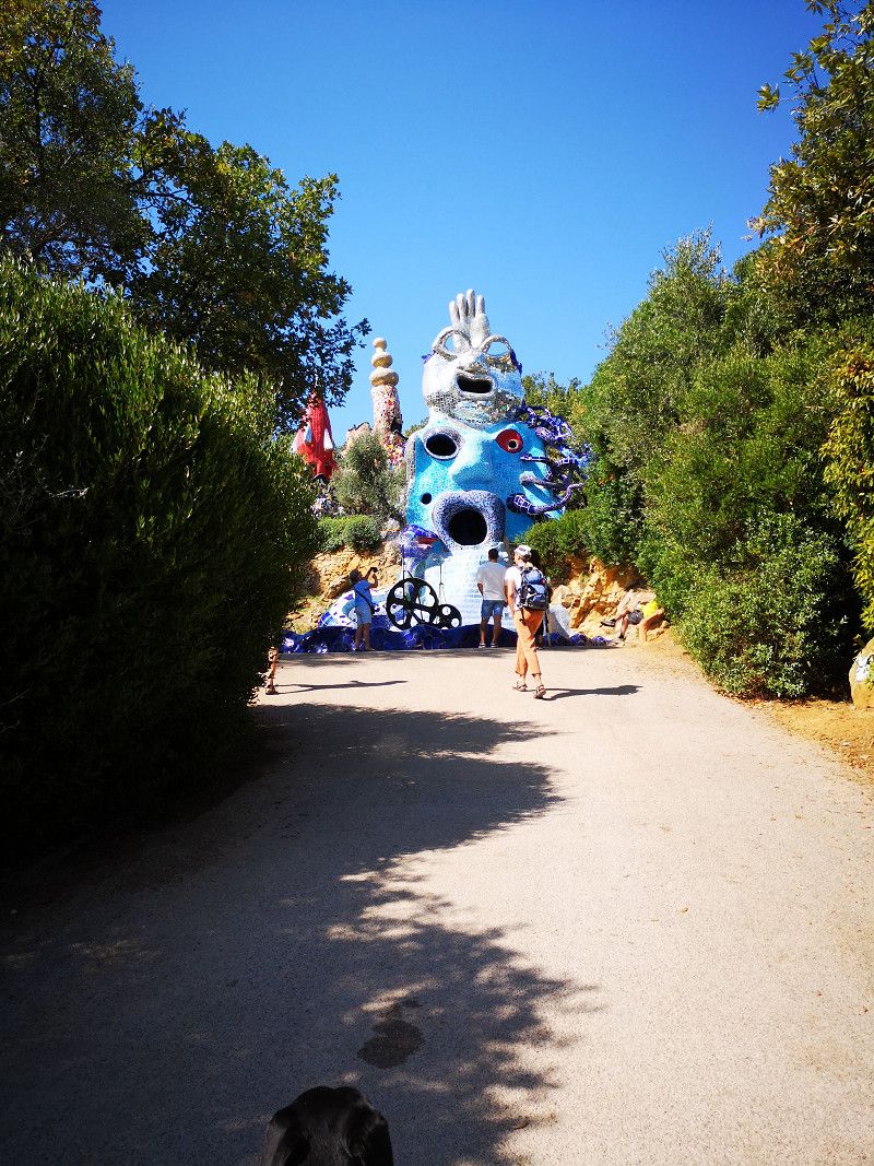
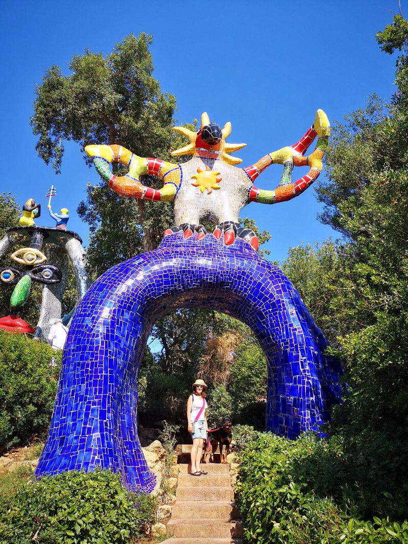
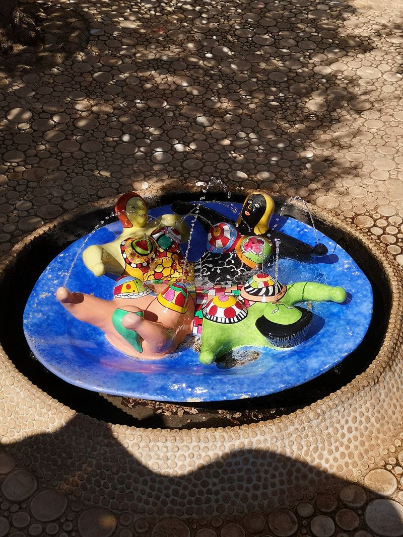
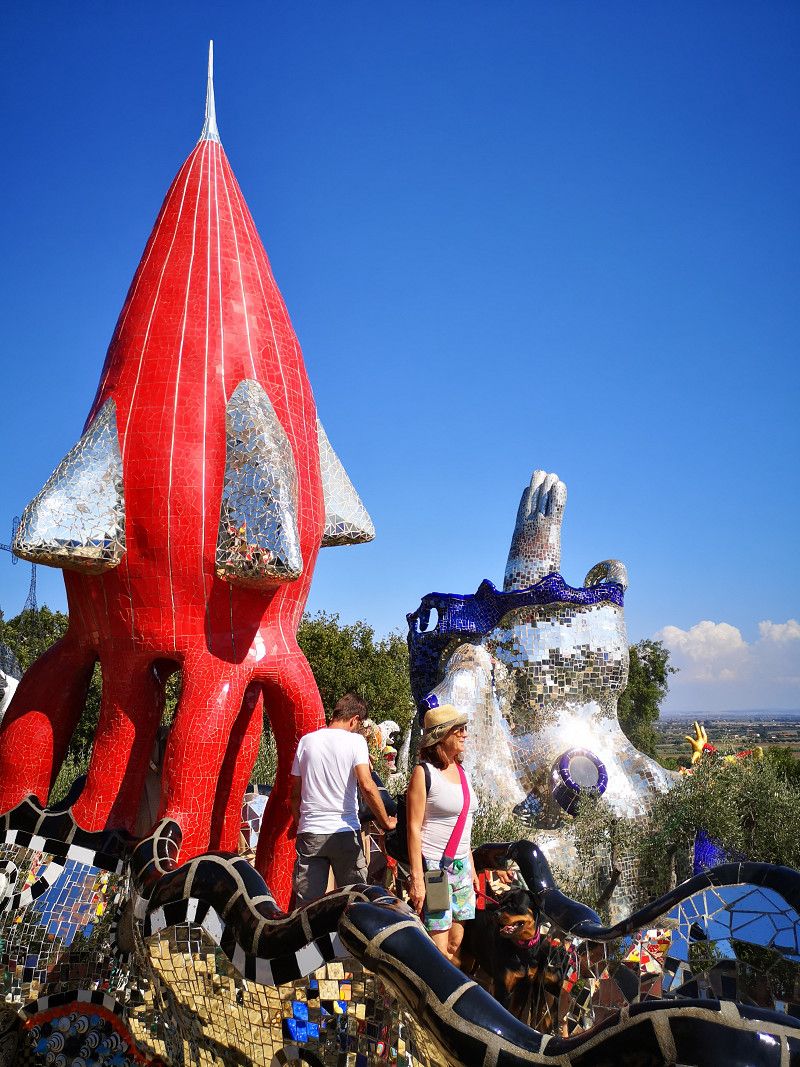
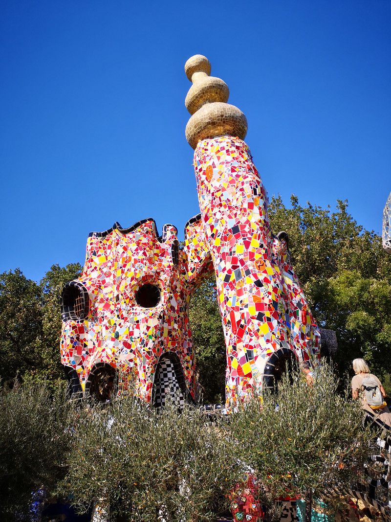
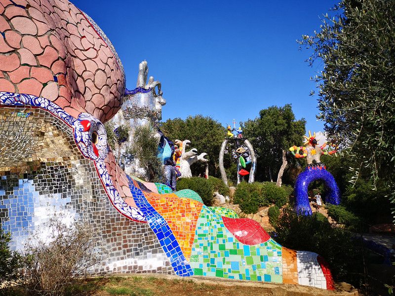
Giardino dei Tarocchi
Strada Provinciale 75 Pescia Fiorentina Chiarone, Capalbio, Grosseto, Toskana, Italien
42° 25' 28.1" N 11° 28' 9.6" E
42.4244825 11.4693378
• Head southeast. Go for 33 m.
• Turn right. Go for 23 m.
• Turn left toward Strada Pescia Fiorentina Chiarone/SP75. Go for 41 m.
• Turn right onto Strada Pescia Fiorentina Chiarone (SP75). Go for 1.1 km.
• Take ramp onto Via Aurelia (SS1) toward Grosseto. Go for 26.3 km.
• Take ramp toward Roma/Albinia/Porto S. Stefano/Manciano. Go for 132 m.
• Take the 1st exit from roundabout onto Via Pietro Aldi (SR74). Go for 254 m.
• Turn right onto Via Lazio. Go for 159 m.
• Arrive at Via Lazio. Your destination is on the left.
☍
28,0 km
( 21 min.)
Übernachtung bei Albinia
Via Lazio 3, Albinia, Grosseto, Italy
42° 29' 57.6" N 11° 12' 20.9" E
42.4993261 11.2058077
• Head toward Via Pietro Aldi on Via Lazio. Go for 159 m.
• Turn left onto Via Pietro Aldi (SR74). Go for 253 m.
• Take the 1st exit from roundabout toward Roma/Orbetello/Argentario/Manciano. Go for 443 m.
• Take the 2nd exit from roundabout toward Porto Ercole/Porto S. Stefano. Go for 109 m.
• Continue on Strada Provinciale Giannella (SP36). Go for 49 m.
• Take the 1st exit from roundabout. Go for 1.7 km.
• Take the 2nd exit from roundabout onto Strada Regionale Maremmana (SR74). Go for 2.3 km.
• Continue toward Strada Provinciale Amiatina/SP160. Go for 37 m.
• Take the 3rd exit from roundabout onto Strada Provinciale Amiatina (SP160). Go for 10.8 km.
• Turn right onto Via dell'Impostino. Go for 161 m.
• Turn right onto Via 20 Settembre. Go for 183 m.
• Turn slightly right onto Via 20 Settembre. Go for 40 m.
• Arrive at Via 20 Settembre. Your destination is on the right.
☍
16,2 km
( 15 min.)
Day
Magliano In Toscana
Via Xx Settembre 6, Magliano In Toscana, Grosseto, Italien
42° 35' 56.1" N 11° 17' 28" E
42.5989160 11.2911200
• Head toward Via della Costituzione on Via 20 Settembre. Go for 280 m.
• Turn right toward Via 24 Maggio. Go for 42 m.
• Continue on Via 24 Maggio. Go for 324 m.
• Continue on Strada Provinciale Amiatina (SP160). Go for 834 m.
• Turn left onto Strada Provinciale Sant'Andrea (SP94). Go for 8.3 km.
• Keep left toward Strada Provinciale Sant'Andrea/SP94. Go for 33 m.
• Turn left onto Strada Regionale Maremmana (SR74). Go for 2.6 km.
• Take the 1st exit from roundabout onto Strada Regionale Maremmana (SR74). Go for 9.0 km.
• Take the 2nd exit from roundabout onto Strada Regionale Maremmana (SR74). Go for 7.4 km.
• Continue on Strada Comunale di Circonvallazione. Go for 639 m.
• Take the 4th exit from roundabout onto Via dell'Imposto (SR74). Go for 296 m.
• Take the 2nd exit from roundabout onto Via Padre Pascucci (SP159). Go for 6.5 km.
• Turn right onto Strada Provinciale Follonata (SP10). Go for 5.3 km.
• Arrive at Strada Provinciale Follonata (SP10). Your destination is on the left.
☍
41,6 km
( 45 min.)
Übernachtung in Saturnia
SP10, Saturnia, Grosseto, Tuscany, Italy
42° 39' 29.8" N 11° 30' 33.7" E
42.6582822 11.5093554
• Head north on Strada Provinciale Follonata (SP10). Go for 1.3 km.
• Turn left. Go for 152 m.
• Turn right toward Strada Comunale Saturnia la Croce. Go for 137 m.
• Turn slightly right onto Strada Comunale Saturnia la Croce. Go for 801 m.
• Continue on Piazzale Benvenuto di Giovanni. Go for 27 m.
• Continue on Via della Chiesa. Go for 147 m.
• Arrive at Via della Chiesa.
☍
2,6 km
( 4 min.)
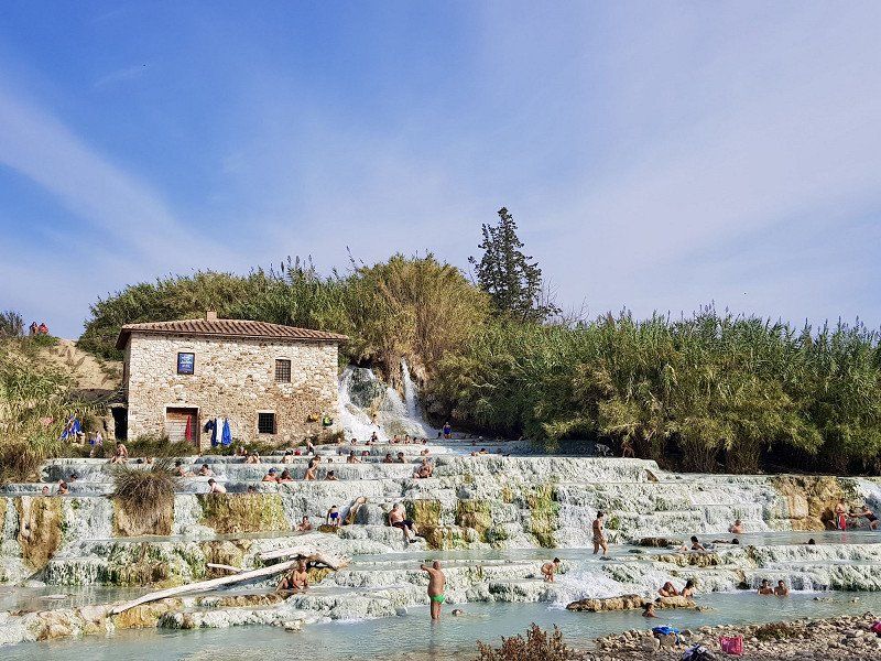
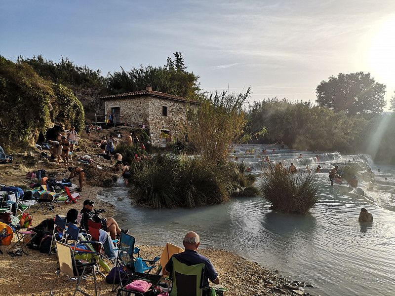
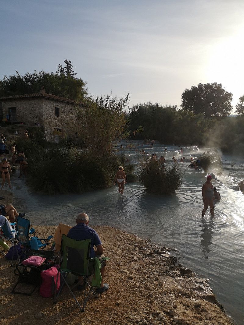
Saturnia, Grosseto, Italien
58014 Saturnia, Grosseto, Italien
42° 39' 47.6" N 11° 30' 15.4" E
42.6632327 11.5042774
• Head east on Via della Chiesa.
• Turn slightly left onto Via Italia. Go for 772 m.
• Continue on Strada Provinciale Follonata (SP10). Go for 8.1 km.
• Turn right onto Via Aldo Moro (SP22). Go for 18.0 km.
• Turn right onto Strada Provinciale Pian della Madonna (SP46). Go for 4.6 km.
• Turn left onto Strada Regionale Maremmana (SR74). Go for 634 m.
• Turn right onto Strada Regionale Maremmana (SR74). Go for 80 m.
• Turn sharp left onto Via Giovanni XXIII (SR74). Go for 32 m.
• Turn right onto Via Don F. Rossi. Go for 46 m.
• Turn left onto Via Carolina Allegretti. Go for 109 m.
• Turn left onto Via Giovanni XXIII (SR74). Go for 40 m.
• Arrive at Via Giovanni XXIII (SR74). Your destination is on the right.
☍
32,4 km
( 40 min.)
Day
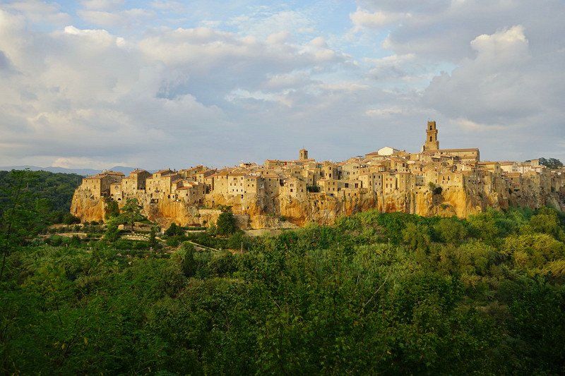
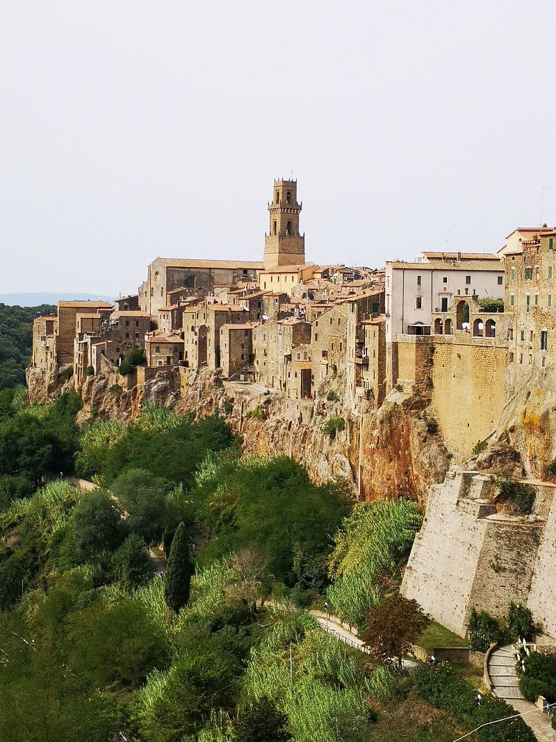
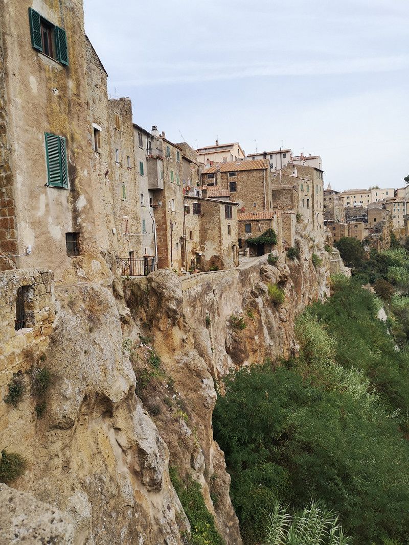
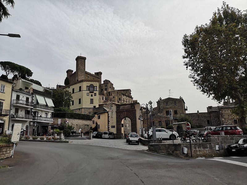
Pitigliano, Grosseto, Italien
58017 Pitigliano, Grosseto, Italien
42° 38' 7.1" N 11° 40' 12" E
42.6353182 11.6699906
• Head toward Via L. Pavolini on Via Giovanni XXIII (SR74). Go for 130 m.
• Turn left onto Via Nicola Ciacci. Go for 344 m.
• Continue on Via N. Ciacci. Go for 60 m.
• Continue on Via Nicola Ciacci. Go for 7.3 km.
• Continue toward Strada Provinciale Pantano/SP127. Go for 25 m.
• Take the 2nd exit from roundabout onto Strada Regionale Maremmana (SR74). Go for 7.0 km.
• Continue on Strada Statale Maremmana (SS74). Go for 750 m.
• Turn left onto Località Cantoniera (SS74). Go for 972 m.
• Turn right onto Strada Provinciale di Gradoli (SP145). Go for 1.5 km.
• Continue on Via Piave. Go for 263 m.
• Continue on Via Indipendenza. Go for 74 m.
• Turn left onto Via Roma. Go for 377 m.
• Continue on Strada Provinciale di Gradoli (SP145). Go for 4.9 km.
• Turn right onto Strada Regionale Cassia (SR2). Go for 7.1 km.
• Turn right onto Viale Santa Maria. Go for 488 m.
• Arrive at Viale Santa Maria. Your destination is on the right.
☍
31,3 km
( 34 min.)
Bolsena
Viale Cadorna 6, Lake Bolsena, Viterbo, Italy
42° 38' 20.1" N 11° 59' 5.6" E
42.6389060 11.9848932
• Head southwest on Viale Santa Maria. Go for 27 m.
• Turn left onto Viale Luigi Cadorna. Go for 118 m.
• Arrive at Viale Luigi Cadorna. Your destination is on the right.
☍
0,1 km
( )
Day
Day
Day
Bolsena
Viale L. Cadorna, Bolsena, Viterbo, Lazio, Italy
42° 38' 15.9" N 11° 59' 4.1" E
42.6377483 11.9844852
• Head northeast on Viale Luigi Cadorna. Go for 118 m.
• Turn right onto Viale Santa Maria. Go for 515 m.
• Turn left onto Via Roma (SR2). Go for 357 m.
• Turn right toward Piazza Giacomo Matteotti. Go for 43 m.
• Continue on Piazza Giacomo Matteotti. Go for 4.6 km.
• Turn slightly left onto Strada Provinciale Bolsenese (SP53). Go for 1.4 km.
• Continue on Strada Provinciale Piansanese (SP13). Go for 1.4 km.
• Turn left onto Strada Statale Umbro Casentinese (SS71). Go for 11.5 km.
• Continue on Via della Gabelletta toward Autostrada/A1. Go for 236 m.
• Turn left onto Strada dell'Arcone toward Orvieto/Sferracavallo. Go for 99 m.
• Turn right toward Strada dell'Arcone. Go for 32 m.
• Take the 1st exit from roundabout onto Via della Segheria. Go for 1.1 km.
• Take the 1st exit from roundabout onto Strada di Porta Romana. Go for 508 m.
• Turn left onto Via Giuseppe Garibaldi. Go for 64 m.
• Turn slightly right onto Via Giuseppe Garibaldi. Go for 118 m.
• Turn right onto Via Cipriano Macente. Go for 167 m.
• Continue on Via Luca Signorelli. Go for 74 m.
• Arrive at Via Luca Signorelli. Your destination is on the left.
☍
22,3 km
( 29 min.)
Day
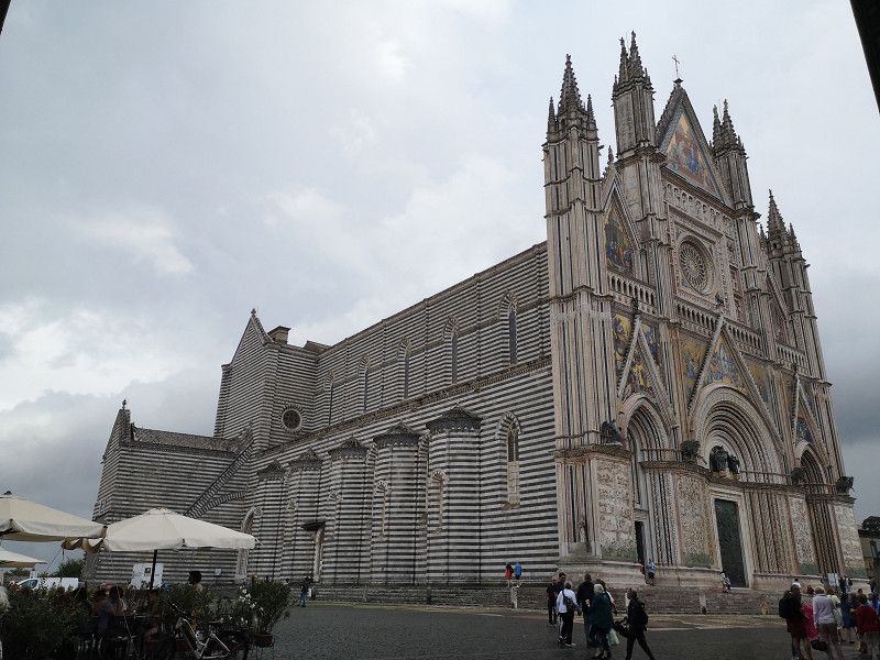
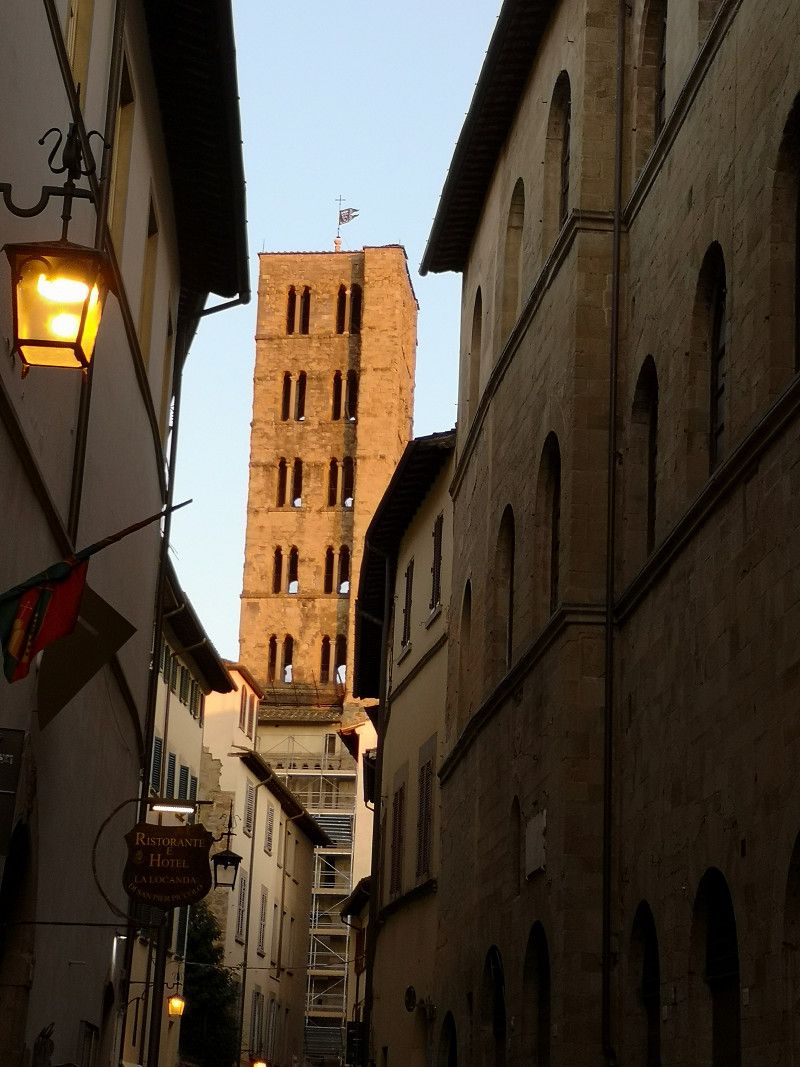
Orvieto, Terni, Italien
05018 Orvieto, Terni, Italien
42° 43' 6.6" N 12° 6' 38.7" E
42.7185068 12.1107446
• Head northeast on Via Luca Signorelli.
• Continue on Piazza Antonio Filippo Gualtieri. Go for 15 m.
• Continue on Via Gualterio. Go for 201 m.
• Turn right onto Via Cesare Nebbia. Go for 180 m.
• Continue on Piazza Gugliemo Marconi. Go for 35 m.
• Turn left onto Piazza Gugliemo Marconi. Go for 51 m.
• Continue on Via Postierla. Go for 560 m.
• Turn right. Go for 199 m.
• Turn right toward Strada Fontana del Leone. Go for 151 m.
• Continue on Strada Fontana del Leone. Go for 154 m.
• Continue on Via Fontana del Leone. Go for 666 m.
• Turn left onto Via Fontana del Leone. Go for 232 m.
• Turn left onto Strada Bagnorese (SS71). Go for 1.4 km.
• Continue toward Roma/A1/Firenze/Todi. Go for 34 m.
• Take the 1st exit from roundabout onto Via Angelo Costanzi (SS205) toward Autostrada/A1/Todi. Go for 680 m.
• Take the 2nd exit from roundabout onto Via Angelo Costanzi (SS205) toward A1/Baschi/Todi. Go for 649 m.
• Turn left toward Firenze/Roma. Go for 20 m.
• Turn right and take ramp onto A1 (Autostrada del Sole) toward Firenze. Go for 41.7 km.
• Take the exit toward Chiusi/Chianciano. Go for 1.1 km.
• Turn right toward Chiusi/Cetona/Chianciano T./Abbadia S.S./Perugia/Castiglion del Lago/Città della Pieve/Fabro. Go for 26 m.
• Turn left onto Strada Provinciale di Chianciano (SP146). Go for 579 m.
• Take the 3rd exit from roundabout onto Strada Provinciale di Chianciano (SP146) toward Chianciano T./Montepulciano/Siena. Go for 7.0 km.
• Take the 2nd exit from roundabout onto Strada Provinciale di Chianciano (SP146). Go for 1.7 km.
• Take the 1st exit from roundabout onto Viale della Libertà (SP40). Go for 1.1 km.
• Take the 1st exit from roundabout onto Viale della Libertà (SP146). Go for 7.6 km.
• Continue on Viale della Rimembranza. Go for 23 m.
• Turn right onto Via del Vecchio Cimitero. Go for 279 m.
• Turn sharp right onto Via del Vecchio Cimitero. Go for 35 m.
• Turn sharp left onto Via dei Filosofi. Go for 200 m.
• Turn right onto Via di Collazzi. Go for 113 m.
• Turn sharp left onto Via di San Donato. Go for 323 m.
• Continue on Piazza Grande. Go for 36 m.
• Turn right onto Piazza Grande. Go for 19 m.
• Arrive at Piazza Grande. Your destination is on the right.
☍
67,1 km
(1 hrs. )
Day
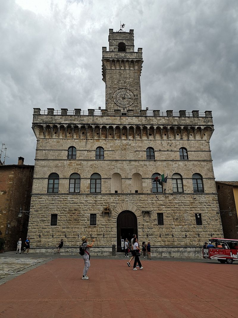
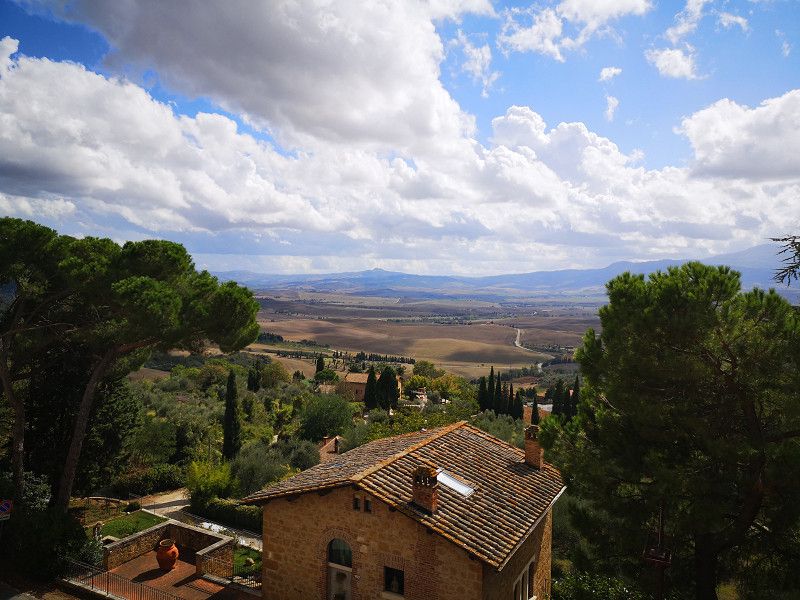
Montepulciano
Siena, Toskana, Italien
43° 5' 33.8" N 11° 46' 51.5" E
43.0927229 11.7809720
• Head toward Via Talosa on Piazza Grande. Go for 29 m.
• Turn right onto Piazza Grande. Go for 23 m.
• Turn slightly left onto Via del Teatro. Go for 161 m.
• Turn slightly left onto Via delle Farine. Go for 145 m.
• Turn sharp right onto Via dell'Oriolo. Go for 60 m.
• Continue on Via di San Pietro. Go for 220 m.
• Turn left onto Via di San Pietro. Go for 61 m.
• Turn left onto Via di San Pietro. Go for 68 m.
• Keep right onto Via della Circonvallazione (SP17). Go for 339 m.
• Continue on Strada per Pienza (SP146). Go for 11.5 km.
• Take the 3rd exit from roundabout onto Strada Provinciale di Chianciano (SP146) toward Pienza/Via S.Gregorio. Go for 838 m.
• Turn slightly left onto Piazza Dante Alighieri. Go for 42 m.
• Turn left onto Piazza Martiri della Libertà. Go for 4 m.
• Continue on Corso Il Rossellino. Go for 28 m.
• Turn left onto Via del Leone. Go for 43 m.
• Turn left onto Via delle Mura. Go for 20 m.
• Arrive at Via delle Mura. Your destination is on the left.
☍
13,6 km
( 17 min.)
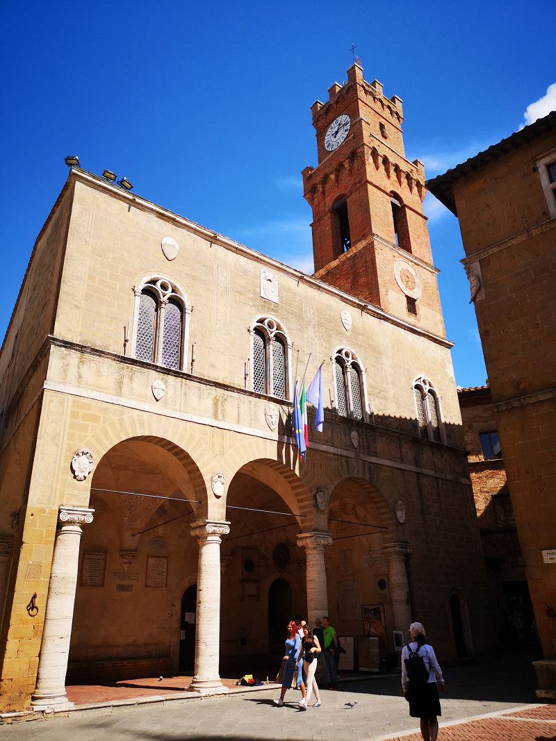
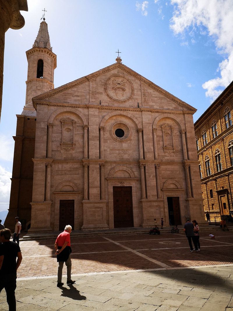
Day
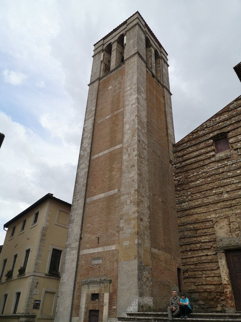
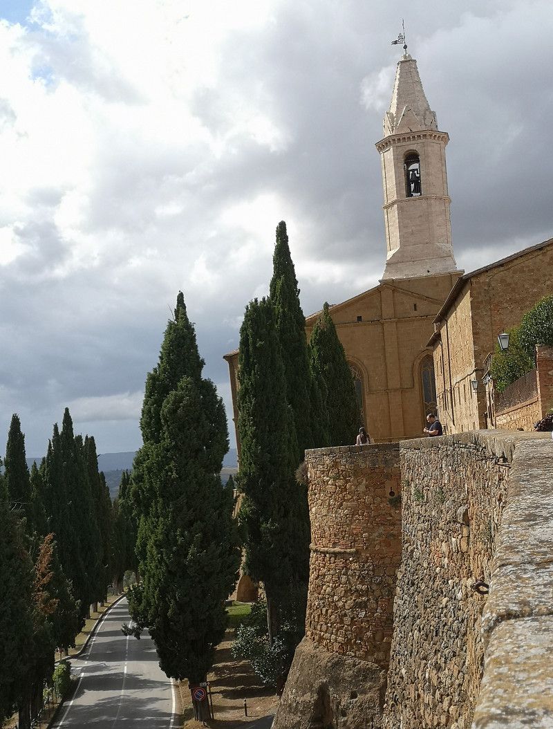
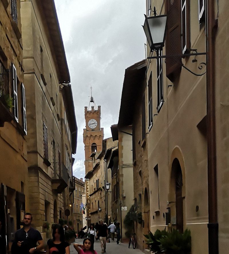
Pienza, Siena, Italien
53026 Pienza, Siena, Italien
43° 4' 38.8" N 11° 40' 39.3" E
43.0774495 11.6775951
• Head toward Via Enzo Mangiavacchi on Via delle Mura. Go for 19 m.
• Turn slightly left onto Strada Provinciale di Chianciano (SP146). Go for 756 m.
• Take the 2nd exit from roundabout onto Strada Provinciale di Chianciano (SP146) toward S.Quirico d'Orcia/Siena/Cassia/SP2. Go for 8.9 km.
• Turn right onto SP137 toward Siena/SS2/Montalcino/SP14. Go for 143 m.
• Turn right and take ramp onto Strada Regionale Cassia (SR2) toward Montalcino/Siena/Grosseto. Go for 5.6 km.
• Take ramp onto Località Bivio dell'Asso (SP14) toward Grosseto/Montalcino/Zona Industriale Bivio Asse. Go for 5.5 km.
• Take the 2nd exit from roundabout onto Traversa dei Monti (SP14) toward Montalcino Centro/Grosseto. Go for 1.8 km.
• Take the 4th exit from roundabout onto Strada Provinciale della Badia di Sant'Antimo (SP55) toward Castelnuovo A./Castelnuovo dell'Abate/Seggiano. Go for 2.0 km.
• Turn left. Go for 304 m.
• Arrive at your destination on the left.
☍
25,0 km
( 29 min.)
Übernachtung in Montalcino
Strada Provinciale della Badia di Sant'Antimo, Montalcino, Siena, Tuscany, Italy
43° 2' 51.4" N 11° 29' 56.6" E
43.0476010 11.4990567
• Head toward Strada Provinciale della Badia di Sant'Antimo. Go for 304 m.
• Turn right onto Strada Provinciale della Badia di Sant'Antimo (SP55). Go for 1.9 km.
• Enter the roundabout. Go for 47 m.
• Arrive at your destination on the left.
☍
2,3 km
( 3 min.)
Day
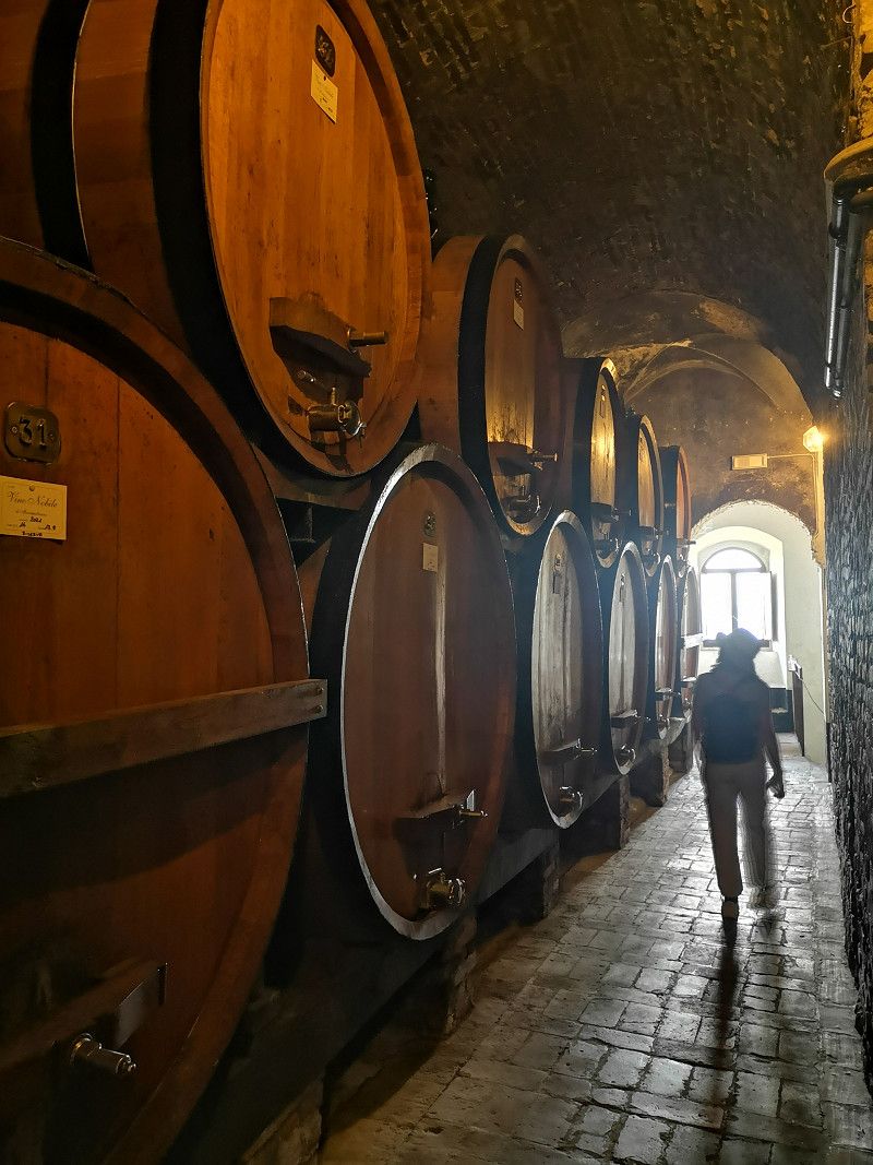
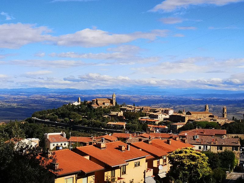
Montalcino, Siena, Italien
Small village, the stay is mainly dedicated to wine... Not much worth seeing.
53024 Montalcino, Siena, Italien
43° 3' 18.4" N 11° 29' 20.4" E
43.0551015 11.4890032
• Follow the roundabout. Go for 19 m.
• Take the 3rd exit from roundabout onto Via Circonvallazione (SP14) toward Autostrada/A1/Roma/SR2/Siena/Torrenieri. Go for 1.7 km.
• Take the 2nd exit from roundabout onto Strada Provinciale del Brunello (SP45) toward Siena/SR2/Buonconvento. Go for 9.5 km.
• Turn left toward Strada Provinciale del Brunello/SP45. Go for 30 m.
• Turn left onto Strada Regionale Cassia (SR2). Go for 12.7 km.
• Take the 4th exit from roundabout onto Strada Regionale Cassia (SR2) toward Firenze-Roma/A1/Arezzo-Perugia/E78/Monteroni d'Arbia/Asciano. Go for 2.1 km.
• Arrive at Via Roma (SR2). Your destination is on the right.
☍
26,1 km
( 28 min.)
Monteroni d'Arbia
Siena, Toskana, Italien
43° 13' 52.3" N 11° 25' 19.3" E
43.2311830 11.4220328
• Head toward Via della Filanda on Via Roma (SR2). Go for 109 m.
• Turn right onto Via San Giusto toward Roma/SP2. Go for 455 m.
• Continue on Via del Poggiarello toward Asciano/Roma. Go for 18 m.
• Turn left onto Via Roma (SR2) toward Asciano/Roma. Go for 70 m.
• Turn left onto Via Lauretana (SP12) toward Asciano. Go for 14.5 km.
• Continue on Strada Provinciale Lauretana (SP438). Go for 271 m.
• Take the 2nd exit from roundabout onto Strada Comunale delle Fonti (SP438) toward Firenze-Roma/A1/Asciano Centro. Go for 7.4 km.
• Keep left onto Strada Lauretana (SP438) toward Sinalunga/Trequanda. Go for 2.3 km.
• Take ramp onto Raccordo Siena-Bettolle (SS326) toward A1/Autostrade. Go for 5.6 km.
• Take ramp toward Rigomagno/Arezzo. Go for 210 m.
• Take the 3rd exit from roundabout onto Traversa Siena (SP11) toward Arezzo. Go for 968 m.
• Continue on Traversa Della Siena-Perugia (SP11a) toward Rigomagno/Arezzo. Go for 1.6 km.
• Continue on Strada Provinciale Siena Cortona (SP28). Go for 837 m.
• Take the 2nd exit from roundabout onto Strada Provinciale Siena Cortona (SP28) toward Arezzo/Lucignano. Go for 1.2 km.
• Continue on Via Fonte Lari toward Lucignano Centro/Arezzo. Go for 509 m.
• Continue on Strada Provinciale Procacci (SP19) toward Firenze/Arezzo. Go for 5.1 km.
• Take left ramp onto Strada di Grande Comunicazione Grosseto-Fano toward Arezzo/Firenze-Roma/A1. Go for 15.0 km.
• Keep right onto Ripa dell'Olmo (SS73) toward Arezzo. Go for 1.7 km.
• Take the 2nd exit from roundabout onto Strada Statale Senese Aretina (SS73) toward Arezzo Zona Stadio/Sansepolcro. Go for 2.1 km.
• Take ramp toward S. Firmina/Gaville/Monastero/Montagnore/Villalba. Go for 777 m.
• Continue on Viale Leonardo da Vinci. Go for 185 m.
• Take the 3rd exit from roundabout onto Viale Duccio di Buoninsegna. Go for 710 m.
• Turn left onto Viale Mecenate. Go for 152 m.
• Turn right onto Via 25 Aprile. Go for 250 m.
• Keep right toward Viale Luca Signorelli. Go for 8 m.
• Keep right onto Viale Luca Signorelli. Go for 137 m.
• Keep left onto Viale Luca Signorelli. Go for 286 m.
• Continue on Largo Inigo Campioni. Go for 76 m.
• Turn right onto Via Mino da Poppi. Go for 165 m.
• Turn slightly left onto Via Bartolomeo di Ser Gorello. Go for 127 m.
• Turn right onto Viale Giacomo Matteotti. Go for 123 m.
• Turn right onto Via Fonte Veneziana. Go for 260 m.
• Continue on Via Francesco Redi. Go for 169 m.
• Turn left onto Via Pier Ludovico Occhini. Go for 147 m.
• Turn left onto Via Francesco Coradini. Go for 230 m.
• Arrive at Via Francesco Coradini. Your destination is on the right.
☍
63,8 km
(1 hrs. 5 min.)
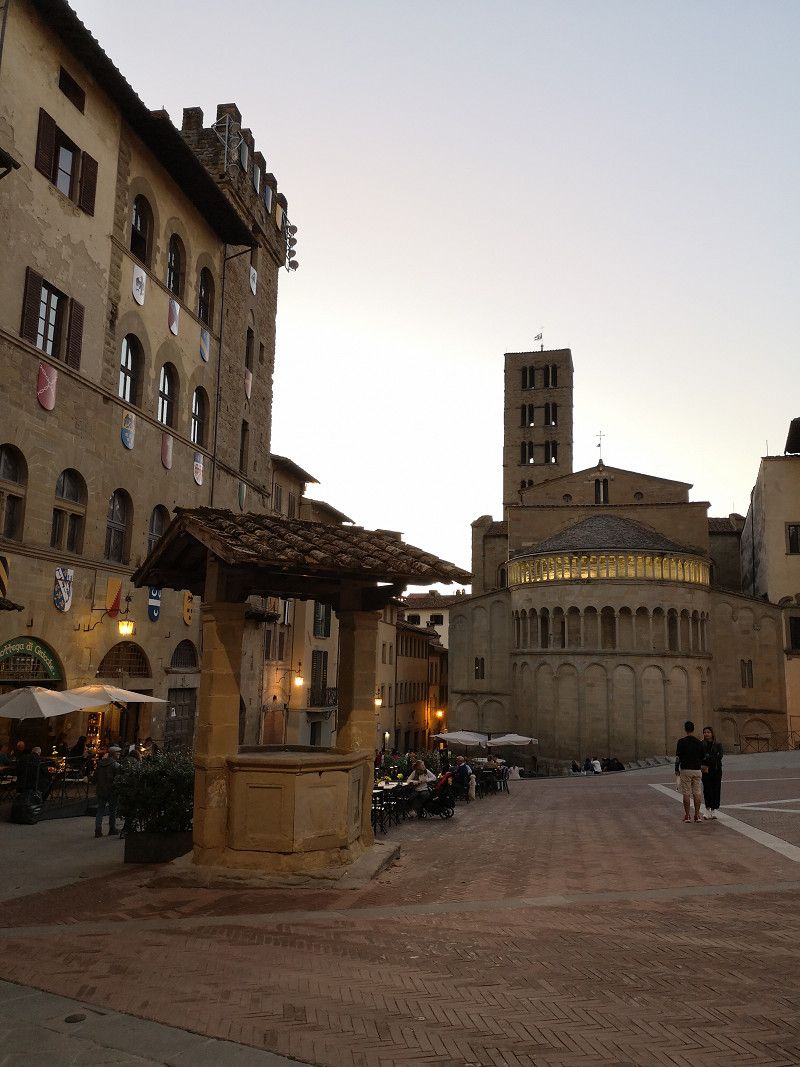
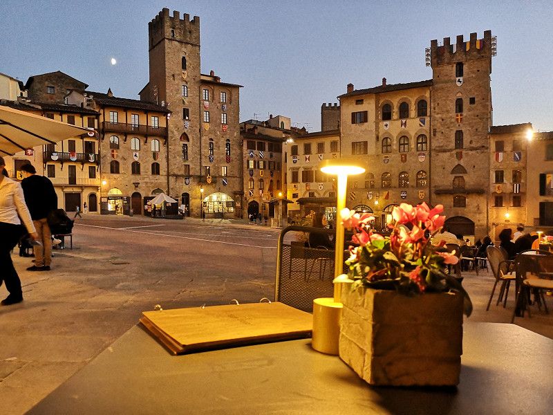
Arezzo
Very beautiful historic city center that invites you to linger. Unfortunately we didn't have enough time planned.
We stayed overnight at the cemetery, very close to the center.
Via Francesco Coradini 13, Arezzo, Arezzo, Italy
43° 27' 55.4" N 11° 53' 31.9" E
43.4653912 11.8922019
• Head northeast on Via Francesco Coradini. Go for 230 m.
• Turn right onto Via Pier Ludovico Occhini. Go for 147 m.
• Turn right onto Via Francesco Redi. Go for 169 m.
• Continue on Via Fonte Veneziana. Go for 260 m.
• Turn right onto Via Antonio da San Gallo. Go for 188 m.
• Continue on Via Francesco Gamurrini. Go for 453 m.
• Continue on Via Guido Tarlati. Go for 787 m.
• Take the 2nd exit from roundabout onto Via Guido Tarlati. Go for 366 m.
• Take the 2nd exit from roundabout onto Via Bernardo Dovizi. Go for 127 m.
• Take the 2nd exit from roundabout onto Via Emilia. Go for 326 m.
• Turn right onto Via della Chimera. Go for 913 m.
• Pass 2 roundabouts and continue on Via Setteponti (SP1). Go for 6.2 km.
• Turn right toward Località Ponte a Buriano/SP56. Go for 675 m.
• Turn right onto Località Ponte a Buriano (SP56). Go for 142 m.
• Keep left onto Località Ponte a Buriano (SP1). Go for 3.1 km.
• Turn right. Go for 630 m.
• Turn left toward Strada Comunale Meliciano. Go for 591 m.
• Turn right onto Strada Comunale Meliciano. Go for 54 m.
• Turn left. Go for 110 m.
• Arrive at your destination on the right.
☍
15,5 km
( 21 min.)
Day
Day
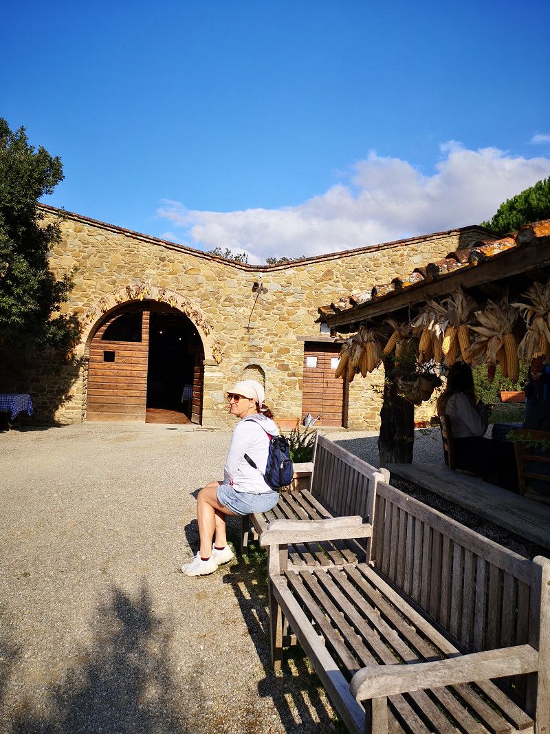
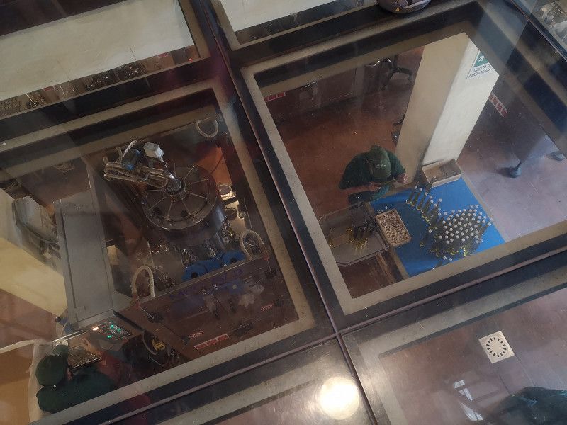
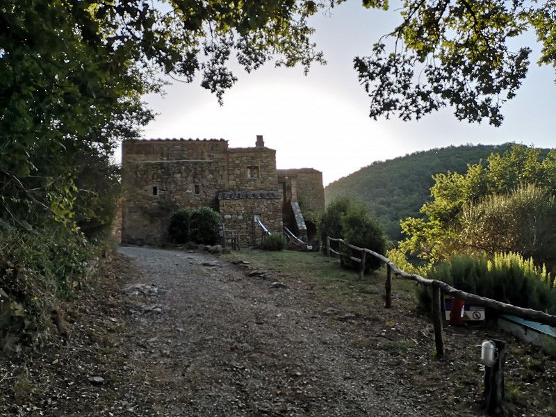
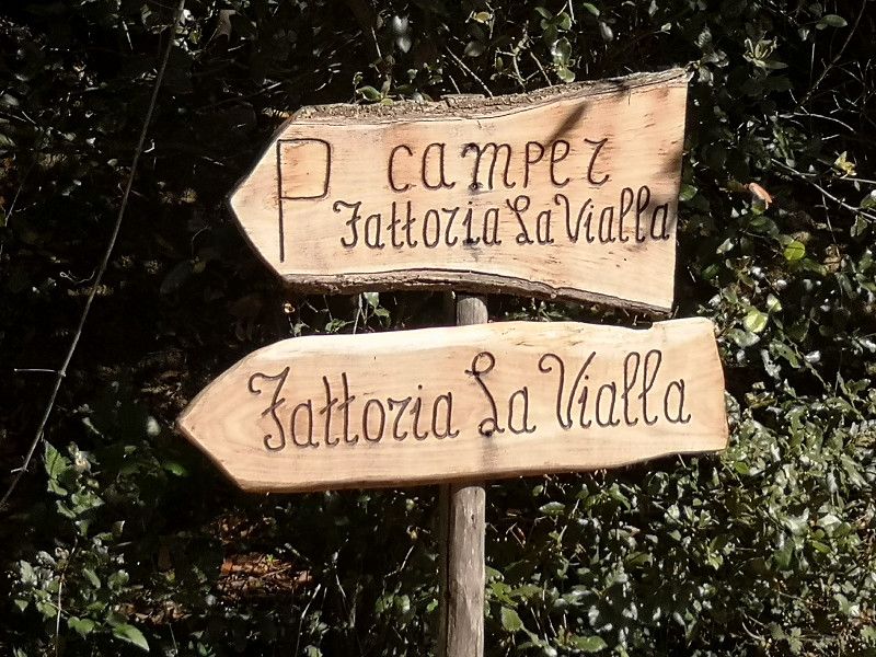
Fattoria La Vialla
Very nice atmosphere with super friendly employees... And good products at real prices... Will organize the visit better next time and take part in the wine festival.
Via di Meliciano 26, Castiglion Fibocchi, Arezzo, Toskana, Italien
43° 31' 43.7" N 11° 46' 48.9" E
43.5288067 11.7802463
• Head toward Località Meliciano. Go for 110 m.
• Turn right onto Strada Comunale Meliciano. Go for 54 m.
• Turn left. Go for 591 m.
• Turn right toward Strada Provinciale Setteponti/SP1. Go for 630 m.
• Turn right onto Strada Provinciale Setteponti (SP1). Go for 1.4 km.
• Take the 2nd exit from roundabout onto Via Setteponti (SP1). Go for 5.9 km.
• Take the 1st exit from roundabout onto Via Girolamo del Borro (SP1). Go for 6.1 km.
• Turn left onto Strada Provinciale Valdarno Casentinese (SP59). Go for 5.9 km.
• Take the 3rd exit from roundabout onto Strada Provinciale Valdarno Casentinese (SP59). Go for 2.4 km.
• Take the 5th exit from roundabout onto Via Ponte Mocarini (SP59). Go for 416 m.
• Turn right onto Strada Provinciale Lungo Arno (SP11). Go for 1.4 km.
• Take the 3rd exit from roundabout onto A1 (Autostrada del Sole) toward Firenze. Go for 35.0 km.
• Take the exit toward Firenze Sud onto SP127 (Raccordo Di Varlungo). Go for 4.1 km.
• Turn sharp left onto Via Enrico De Nicola toward Centro/Viali di Circonvallazione. Go for 736 m.
• Take the 1st exit from Largo Jean-Michel Folon roundabout onto Via della Casaccia. Go for 149 m.
• Take the 2nd exit from roundabout onto Via del Gignoro. Go for 254 m.
• Take the 3rd exit from Via del Gignoro roundabout onto Via del Gignoro toward Fiesole. Go for 296 m.
• Pass 2 roundabouts and continue on Via del Gignoro. Go for 590 m.
• Continue on Piazza San Bartolomeo al Gignoro. Go for 20 m.
• Keep left onto Piazza San Bartolomeo al Gignoro toward Coverciano. Go for 62 m.
• Take the 2nd exit from Piazza San Bartolomeo al Gignoro roundabout onto Viale Giovanni Verga. Go for 314 m.
• Turn right onto Via Federigo Tozzi. Go for 221 m.
• Continue on Via dei Fontebuoni. Go for 349 m.
• Take the 1st exit from Via Lungo l'Affrico roundabout onto Via Lungo l'Affrico. Go for 281 m.
• Keep left onto Via Lungo l'Affrico. Go for 218 m.
• Continue on Viale Augusto Righi. Go for 31 m.
• Keep right onto Viale Augusto Righi. Go for 786 m.
• Continue on Viale Alessandro Volta toward San Domenico/Fiesole. Go for 48 m.
• Turn right onto Piazza Thomas Alva Edison toward San Domenico/Fiesole. Go for 8 m.
• Continue on Via San Domenico. Go for 1.9 km.
• Continue on Via David Sassoli. Go for 120 m.
• Continue on Strada Provinciale S. Domenico Fiesole (SP53). Go for 138 m.
• Continue on Via Giuseppe Mantellini (SP53). Go for 2.3 km.
• Take the 2nd exit from Piazza Mino da Fiesole roundabout onto Piazza Mino da Fiesole (SP53). Go for 1.3 km.
• Turn right onto Via Peramonda. Go for 457 m.
• Turn slightly right onto Via Corsica. Go for 28 m.
• Turn right onto Via Poggio Magherini. Go for 156 m.
• Arrive at Via Poggio Magherini. Your destination is on the right.
☍
74,7 km
(1 hrs. 8 min.)
Day
Camping Florenz
Via Poggio Magherini 10, Fiesole, Firenze, Italy
43° 48' 24" N 11° 18' 17.2" E
43.8066622 11.3047841
• Head toward Via Corsica on Via Poggio Magherini. Go for 156 m.
• Turn right onto Via Corsica. Go for 281 m.
• Turn right onto Via Francesco Colzi. Go for 166 m.
• Turn left onto Via Giacomo Matteotti (SP53). Go for 754 m.
• Take the 2nd exit from Piazza Mino da Fiesole roundabout onto Piazza Mino da Fiesole (SP53). Go for 2.4 km.
• Continue on Via David Sassoli. Go for 120 m.
• Continue on Via San Domenico. Go for 1.9 km.
• Continue on Piazza Thomas Alva Edison. Go for 1.1 km.
• Turn left onto Via Dogali. Go for 97 m.
• Turn left onto Viale dei Mille. Go for 137 m.
• Turn right onto Via Antonio Pacinotti. Go for 211 m.
• Continue on Piazza Giorgio Vasari. Go for 51 m.
• Continue on Via degli Artisti. Go for 442 m.
• Continue on Piazzale Donatello. Go for 87 m.
• Turn slightly left onto Piazzale Donatello. Go for 71 m.
• Take the 1st exit from Piazzale Donatello roundabout onto Piazzale Donatello toward Via Aretina/SS67/Piazza Beccaria/Autostrade/A11/A1. Go for 141 m.
• Continue on Viale Antonio Gramsci. Go for 1.2 km.
• Keep right onto Viale della Giovine Italia. Go for 102 m.
• Continue on Lungarno della Zecca Vecchia. Go for 419 m.
• Turn slightly right onto Piazza dei Cavalleggeri. Go for 44 m.
• Continue on Corso dei Tintori. Go for 232 m.
• Turn right onto Via dei Benci. Go for 167 m.
• Continue on Piazza di Santa Croce. Go for 19 m.
• Turn left onto Via dell'Anguillara. Go for 261 m.
• Continue on Via della Condotta. Go for 135 m.
• Turn left onto Via delle Farine. Go for 29 m.
• Turn slightly right onto Piazza della Signoria. Go for 50 m.
• Turn right onto Piazza della Signoria. Go for 19 m.
• Arrive at Piazza della Signoria. Your destination is on the right.
☍
10,8 km
( 20 min.)
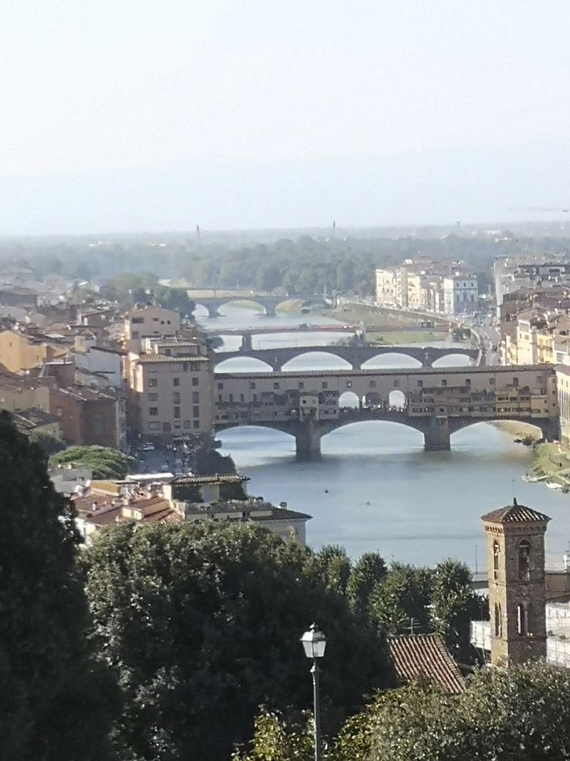
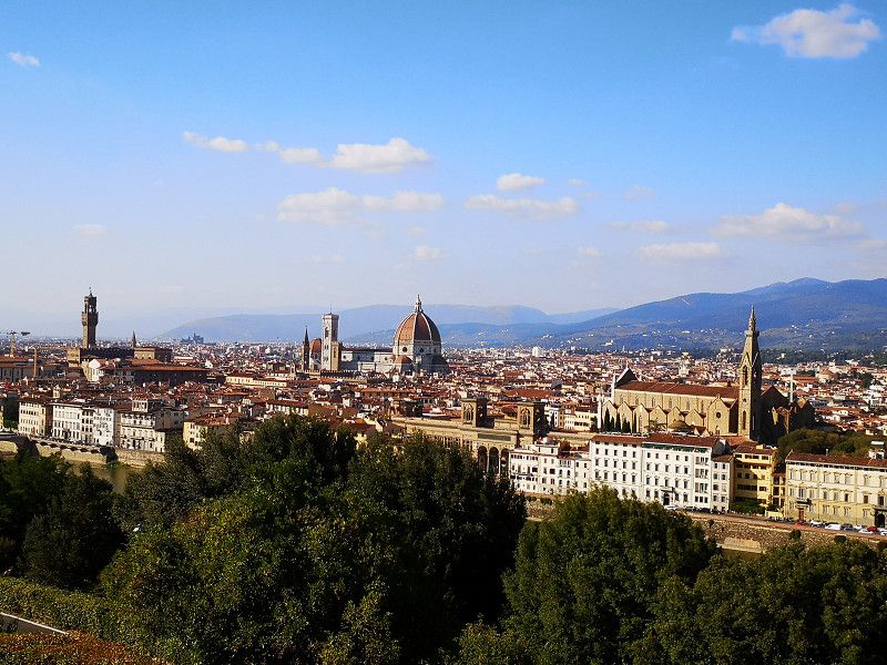
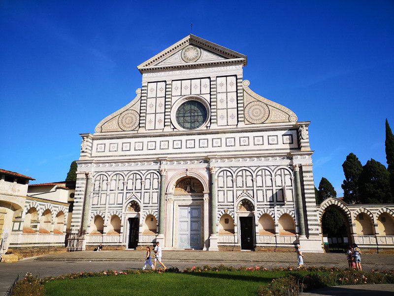
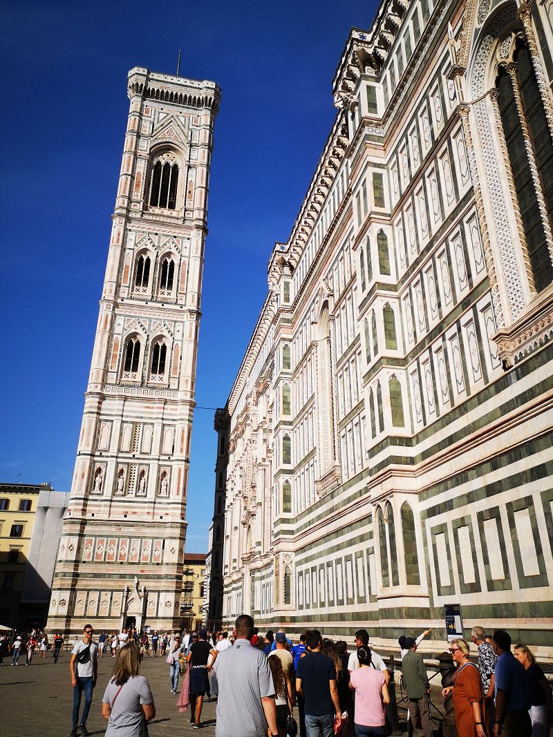
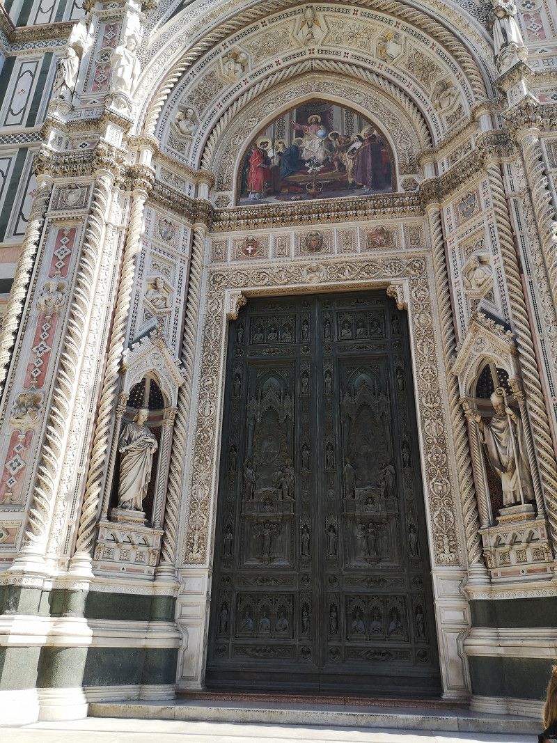
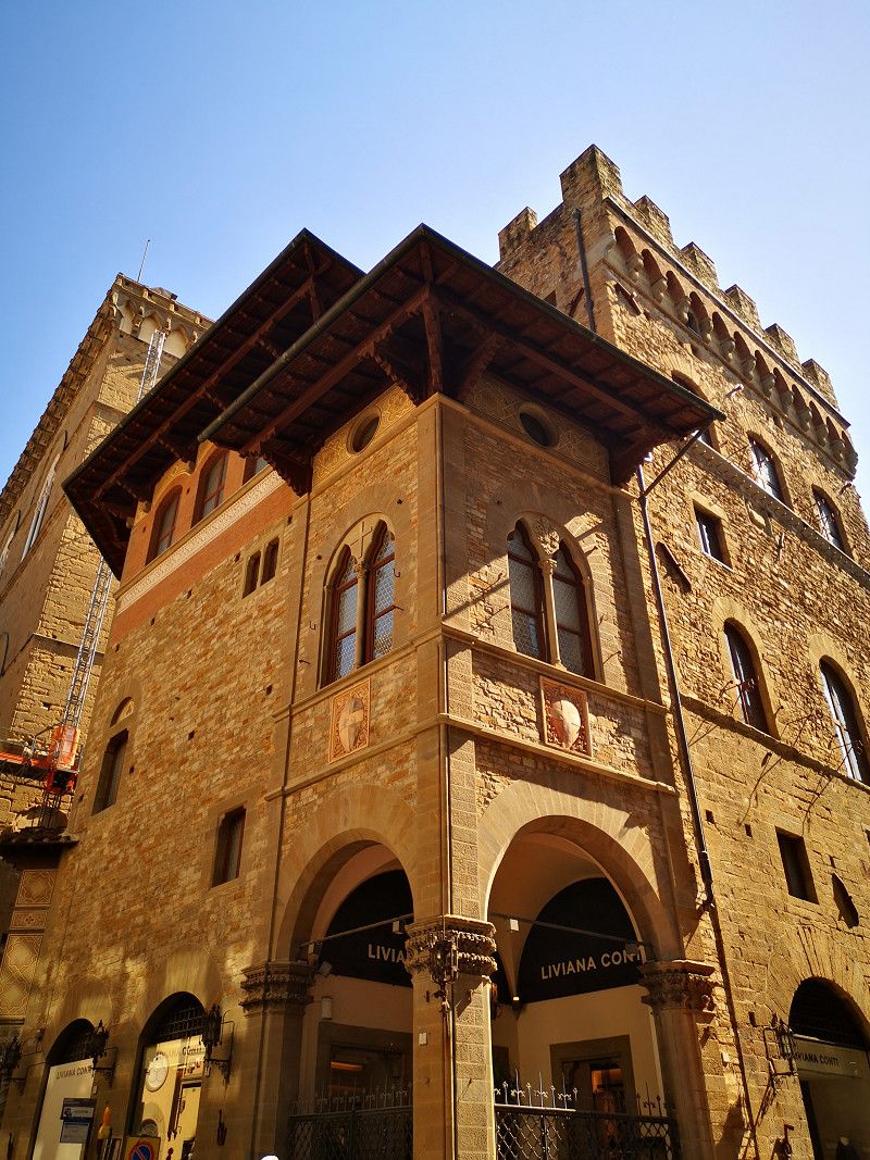
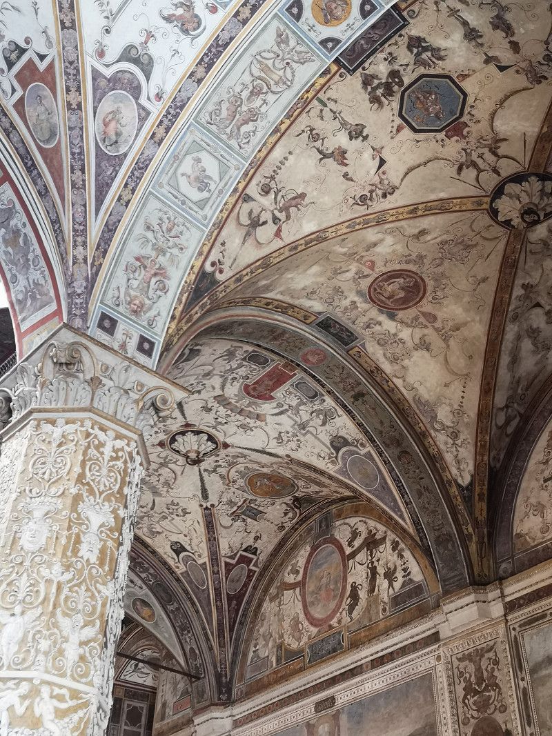
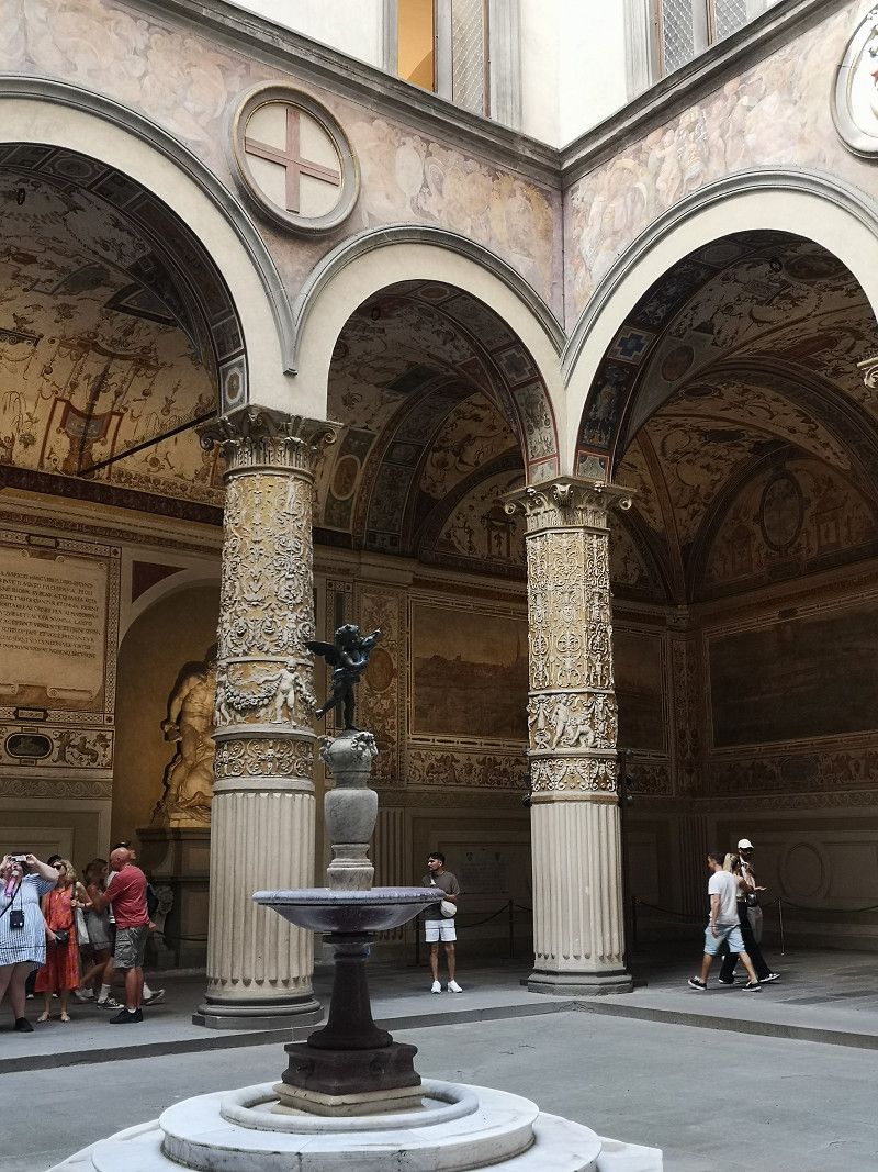
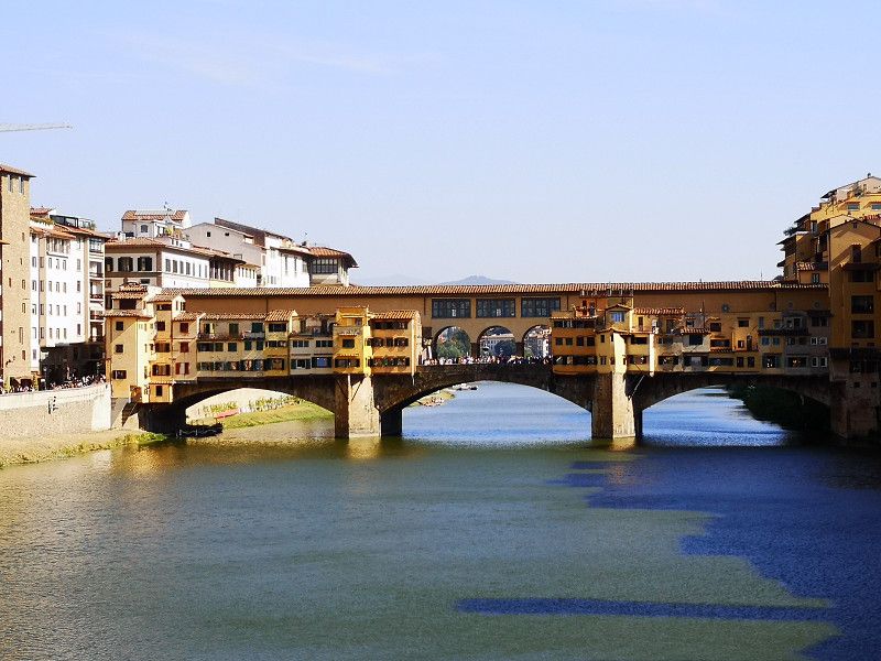
Florenz
Florence is a must visit... Duomo di Santa Maria, Ponte Vecchio, Palazzo di Medici and many other beautiful squares and buildings
Firenze, Toskana, Italien
43° 46' 11.5" N 11° 15' 20.1" E
43.7698712 11.2555757
• Head southeast on Piazza della Signoria. Go for 19 m.
• Turn right onto Piazza della Signoria. Go for 41 m.
• Turn left onto Piazza della Signoria. Go for 60 m.
• Turn slightly right onto Via della Ninna. Go for 103 m.
• Turn slightly right onto Piazza del Grano. Go for 65 m.
• Continue on Via dei Castellani. Go for 75 m.
• Continue on Via dei Saponai. Go for 95 m.
• Continue on Piazza Mentana. Go for 27 m.
• Turn right onto Piazza Mentana. Go for 55 m.
• Turn left onto Lungarno Generale Armando Diaz. Go for 100 m.
• Continue on Lungarno delle Grazie. Go for 242 m.
• Continue on Piazza dei Cavalleggeri. Go for 33 m.
• Continue on Lungarno della Zecca Vecchia. Go for 419 m.
• Continue on Lungarno Guglielmo Pecori Giraldi. Go for 257 m.
• Keep left onto Viale Giovanni Amendola toward Viale Circonvallazione/Centro/Aeroporto A. Vespucci. Go for 335 m.
• Keep right onto Viale Giovanni Amendola. Go for 930 m.
• Continue on Piazzale Donatello toward Piazza Libertà/Autostrade. Go for 183 m.
• Take the 1st exit from roundabout onto Piazzale Donatello toward Piazza Libertà. Go for 692 m.
• Continue on Piazza della Libertà. Go for 327 m.
• Keep right onto Viale Spartaco Lavagnini toward Aeroporto Amerigo Vespucci/A1/Autostrade/A11/Prato-Pisa. Go for 716 m.
• Turn right onto Viale Filippo Strozzi. Go for 556 m.
• Keep right onto Viale Filippo Strozzi toward Ponte della Vittoria/Aeroporto/S.G.C. FI-PI-LI/Siena/Milano/A1/Pisa/A11. Go for 206 m.
• Continue on Viale Belfiore. Go for 105 m.
• Keep right onto Viale Francesco Redi toward Novoli/Aeroporto A. Vespucci/Autostrade/A1/A11/Sesto Fiorentino-Prato/Campi Bisenzio-Pistoia. Go for 1.5 km.
• Continue on Via di Novoli toward Aeroporto/Autostrade/A1/A11/Sesto Fiorentino-Prato/Campi Bisenzio-Pistoia. Go for 103 m.
• Take the 1st exit from Via di Novoli roundabout onto Via Enrico Forlanini toward Ospedale Careggi/A1/Autostrade/A11/Campi Bisenzio-Pistoia. Go for 550 m.
• Continue on Viale Alessandro Guidoni toward Campi B.-Prato/A1/Autostrade/A11. Go for 12 m.
• Turn left onto Viale Alessandro Guidoni toward Aeroporto/A1/Autostrade/A11/Sesto Fiorentino-Prato/Campi Bisenzio-Pistoia. Go for 1.9 km.
• Turn right onto Viale Undici Agosto. Go for 239 m.
• Keep middle onto Viale Undici Agosto toward Autostrade/A11/A1/Aeroporto A. Vespucci/Prato-Pistoia. Go for 157 m.
• Continue on Viale Giovanni Luder. Go for 294 m.
• Keep right onto Viale Giovanni Luder toward Aeroporto A. Vespucci/Osmannoro/Firenze-Mare/A11/Milano-Napoli/A1/Prato-Pistoia. Go for 390 m.
• Keep middle onto Autostrada Firenze Mare (A11) toward Firenze-Mare/Milano-Napoli/A1/Prato-Pistoia. Go for 67.0 km.
• Take the exit toward Lucca Ovest/Viareggio/E80/Genova/A12 onto A11 (Diramazione Viareggio-Lucca). Go for 19.4 km.
• Take the exit toward Genova/E31/A15/Parma onto A12 (Autostrada Azzurra). Go for 67.3 km.
• Take the exit toward Levanto. Go for 1.6 km.
• Turn left onto Via Levanto (SP566dir) toward Levanto/Monterosso/SS370/Bonassola/Cinque Terre. Go for 9.9 km.
• Take the 2nd exit from roundabout onto Via Nostra Signora della Guardia (SP566dir) toward Centro. Go for 564 m.
• Take the 4th exit from roundabout onto Strada Provinciale Albero d'Oro (SP43) toward Genova-Livorno/A12/Parma/A15/Carrodano/Monterosso/La Spezia. Go for 166 m.
• Turn left onto Località Albero d'Oro (SP43). Go for 5.4 km.
• Continue toward SP38. Go for 28 m.
• Continue on SP38. Go for 119 m.
• Continue on Località Colle di Gritta (SP38). Go for 135 m.
• Continue on Galleria Colle di Gritta (SP38). Go for 84 m.
• Continue on SP38. Go for 335 m.
• Continue on Galleria Soviore (SP38). Go for 80 m.
• Continue on SP38. Go for 1.1 km.
• Continue on Galleria Rondanara. Go for 66 m.
• Continue on SP38. Go for 1.2 km.
• Turn right onto Località Serra (SP38). Go for 990 m.
• Turn slightly right onto SP38. Go for 281 m.
• Continue on Via Soviore (SP38). Go for 285 m.
• Continue on Via Roma (SP38). Go for 435 m.
• Turn left toward Piazza Giuseppe Garibaldi. Go for 65 m.
• Turn left onto Piazza Giuseppe Garibaldi. Go for 45 m.
• Arrive at Piazza Giuseppe Garibaldi. Your destination is on the left.
☍
187,4 km
(2 hrs. 13 min.)
Day
Day
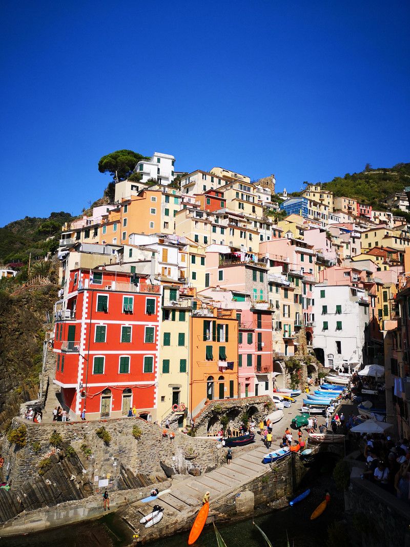
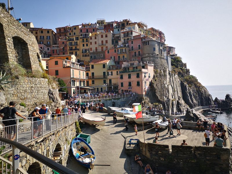
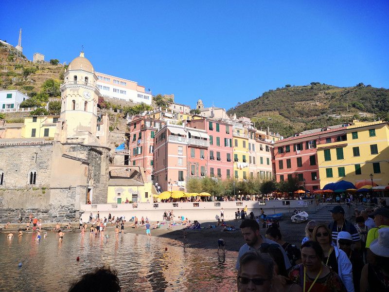
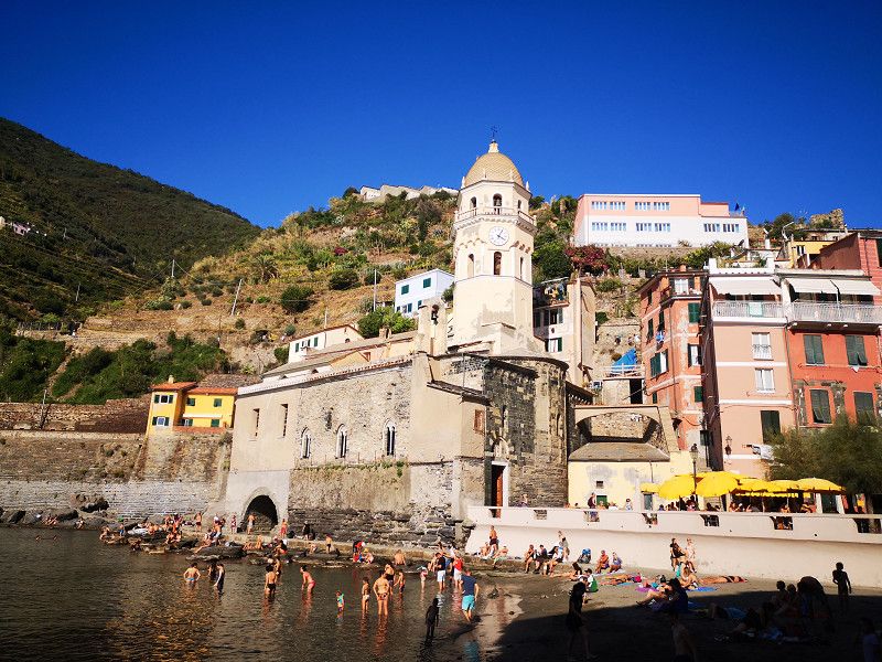
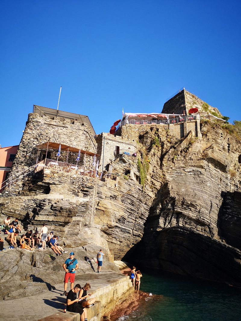
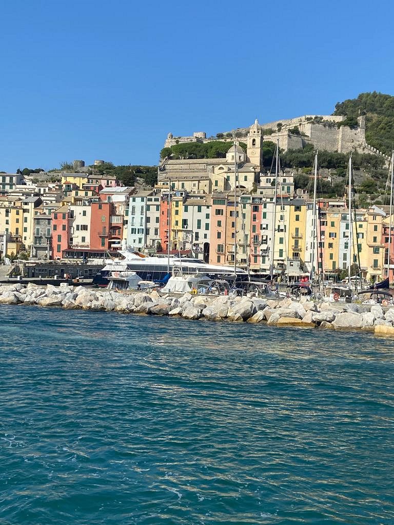
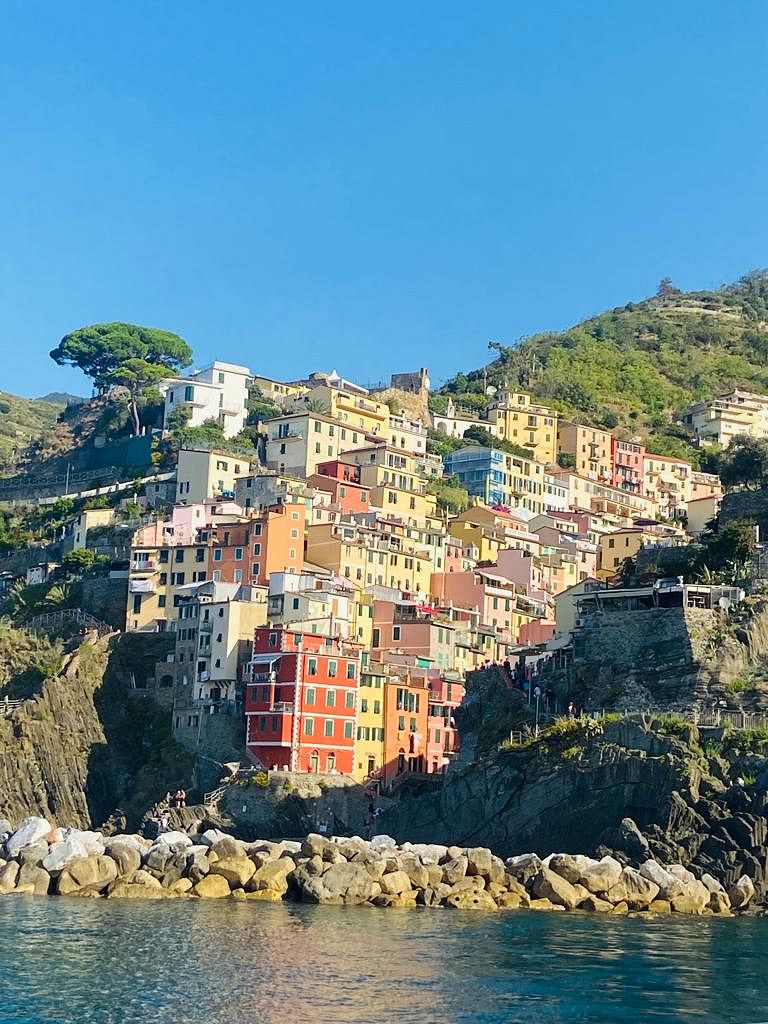
Cinque Terre
Be sure to visit the villages starting from Monterosso to Vernazza... to Porto Verdere and back by boat (day ticket €39 per person).
It's best to reserve a parking space in Monterosso by phone in advance, very nice operators... You can also find out more in Parkforanight.
La Spezia, Ligurien, Italien
44° 8' 47.5" N 9° 39' 20" E
44.1465216 9.6555583
• Head toward Via Servano on Piazza Giuseppe Garibaldi. Go for 45 m.
• Turn right toward Via Roma. Go for 65 m.
• Turn right onto Via Roma. Go for 398 m.
• Turn slightly right onto Via Roma (SP38). Go for 37 m.
• Continue on Via Soviore (SP38). Go for 285 m.
• Continue on SP38. Go for 281 m.
• Turn slightly left onto Località Serra (SP38). Go for 990 m.
• Continue on SP38. Go for 78 m.
• Turn right onto SP38. Go for 1.2 km.
• Continue on Galleria Rondanara. Go for 66 m.
• Continue on SP38. Go for 1.1 km.
• Continue on Galleria Soviore (SP38). Go for 80 m.
• Continue on SP38. Go for 335 m.
• Continue on Galleria Colle di Gritta (SP38). Go for 84 m.
• Continue on Località Colle di Gritta (SP38). Go for 135 m.
• Continue on SP38. Go for 147 m.
• Continue on Località Piè di Legnaro (SP43). Go for 5.4 km.
• Turn right onto Strada Provinciale Albero d'Oro (SP43) toward Centro/Genova-Livorno/A12/Genova. Go for 139 m.
• Take the 1st exit from roundabout onto Via Nostra Signora della Guardia (SP566dir) toward Genova/Parma/A15/Genova-Livorno/A12/Carrodano/Montale. Go for 556 m.
• Take the 2nd exit from roundabout onto Località San Gottardo (SP566dir) toward A12/Autostrade/A15/Casella/Carrodano/Montale. Go for 9.9 km.
• Take ramp onto A12 (Autostrada Azzurra) toward Parma/A15/Livorno/E31. Go for 26.3 km.
• Take the exit toward Parma onto A15 (Autostrada della Cisa). Go for 100 km.
• Take the left exit onto A1 (Autostrada del Sole). Go for 28.5 km.
• Take the exit toward Cremona/A21/Brescia/Fiorenzuola. Go for 402 m.
• Keep right onto A21dir (D21) toward Cremona/A21/Brescia/E70. Go for 12.1 km.
• Continue on A21 (Autostrada Torino-Piacenza-Brescia). Go for 56.0 km.
• Take the left exit toward Milano onto A4 (Autostrada della Serenissima). Go for 7.2 km.
• Take the exit toward Brescia Ovest. Go for 462 m.
• Keep left toward Orzinuovi/Crema/Roncadelle/Milano. Go for 40 m.
• Continue on Via Tangenziale Sud. Go for 30 m.
• Take the 3rd exit from roundabout onto Tangenziale Brescia Sud (SPBS11var) toward Milano/A35. Go for 4.0 km.
• Keep right onto Strada Provinciale Sebina Orientale (SPBS510DIR) toward Pisogne/SPBS510/Rodengo Saiano. Go for 1.5 km.
• Keep left onto Strada Provinciale Sebina Orientale (SPBS510DIR) toward Pisogne/SPBS510/Zona Industriale Moie. Go for 12.0 km.
• Turn right toward Strada Provinciale Iseo-Polaveno/SP48. Go for 54 m.
• Turn right onto Strada Provinciale Iseo-Polaveno (SP48). Go for 4.7 km.
• Turn left. Go for 68 m.
• Arrive at your destination on the left.
☍
274,9 km
(2 hrs. 51 min.)
Day
Day
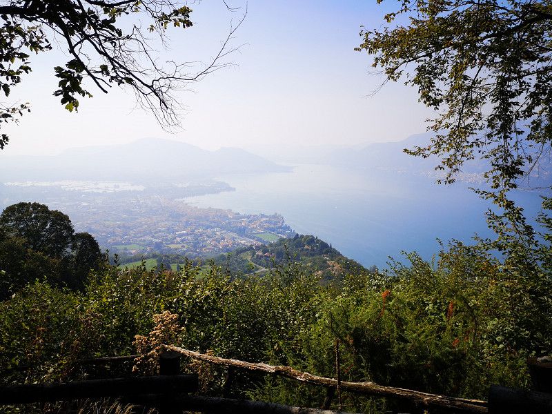
Iseosee - Agritourisme la Tesa
Approximately 30 shady places... From the berths there is a great view over the lake
Via Silvio Bonomelli, Iseo, Brescia, Lombardy, Italy
45° 39' 49.8" N 10° 4' 46.6" E
45.6638466 10.0796090
• Head toward Strada Provinciale Iseo-Polaveno. Go for 68 m.
• Turn right onto Strada Provinciale Iseo-Polaveno (SP48). Go for 5.3 km.
• Take ramp onto Strada Provinciale Sebina Orientale (SPBS510) toward Autostrade/Clusane/Sarnico/Rovato/Brescia. Go for 568 m.
• Take the 2nd exit from roundabout onto Montecognolo (SPBS510) toward Brescia. Go for 11.0 km.
• Keep right onto Strada Provinciale Sebina Orientale (SPBS510DIR) toward Aeroporto Montichiari/Ospitaletto/A4/Tangenziale Sud-Brescia/SS11/Castegnato. Go for 2.7 km.
• Continue on Tangenziale Brescia Sud (SPBS11var). Go for 3.5 km.
• Take ramp toward E64/A4. Go for 525 m.
• Take left ramp onto A4 (Autostrada Torino-Trieste) toward Torino/A21/Piacenza/Venezia/E66. Go for 6.1 km.
• Take the exit toward Torino/Piacenza/Cremona/La Spezia/A15 onto A21 (Autostrada Torino-Piacenza-Brescia). Go for 56.5 km.
• Keep right onto A21dir (D21) toward E70/Fiorenzuola/A21/E31/Parma-La Spezia/A15/E45/Bologna/A1. Go for 12.8 km.
• Take the exit toward Fiorenzuola onto SP462r (Località Barabasca). Go for 1.9 km.
• Take the 1st exit from roundabout onto Strada Statale di Val d'Arda (SP462r). Go for 1.6 km.
• Take ramp onto Via Emilia (SS9) toward Piacenza. Go for 2.1 km.
• Turn left onto Strada Comunale della Pelosa toward S. Protaso. Go for 782 m.
• Turn right onto Strada Comunale della Pelosa. Go for 1.4 km.
• Arrive at Strada Comunale della Pelosa.
☍
106,9 km
(1 hrs. 8 min.)
Day
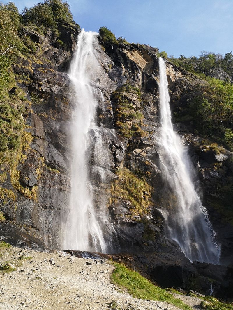
Chiavenna
Overnight stay on the free parking space... It was ok... Free tour of the waterfall
Italien
44° 56' 20" N 9° 51' 29" E
44.9388881 9.8580457
• Head north on Strada Comunale della Pelosa. Go for 1.4 km.
• Turn left onto Strada Comunale della Pelosa. Go for 782 m.
• Turn right onto Via Emilia (SS9). Go for 2.0 km.
• Take ramp onto Strada Statale di Val d'Arda (SP462r) toward Autostrada/A1/Cortemaggiore. Go for 2.0 km.
• Take the 2nd exit from roundabout onto Strada Statale di Val d'Arda (SP462r). Go for 502 m.
• Take ramp onto A1 (Autostrada del Sole) toward Milano. Go for 76.9 km.
• Continue on A51 (Tangenziale Est). Go for 10.8 km.
• Keep right onto A52 (Tangenziale Nord) toward E64/Torino/A4/Aeroporto Malpensa. Go for 6.1 km.
• Take the exit toward Lecco/SS36/Monza/Villa Reale onto Viale Brianza. Go for 501 m.
• Continue on Viale Lombardia (SS36). Go for 134 m.
• Keep left onto Strada Statale Nuova Valassina (SS36) toward Lecco/Monza/Ospedale San Gerardo. Go for 14.1 km.
• Keep left onto Strada Statale del Lago di Como e dello Spluga (SS36) toward Lecco/Sondrio. Go for 67.0 km.
• Take ramp toward Colico/SP72/Chiavenna/SS36/Madesimo. Go for 311 m.
• Take the 3rd exit from roundabout onto Strada Statale del Lago di Como e dello Spluga (SS36) toward Chiavenna/Menaggio/SS148/St.Moritz. Go for 723 m.
• Pass 2 roundabouts and continue on Strada Statale del Lago di Como e dello Spluga (SS36). Go for 3.2 km.
• Take the 3rd exit from roundabout onto Strada Statale del Lago di Como e dello Spluga (SS36) toward Chiavenna/Spluga/St.Moritz/Lugano/Como. Go for 6.5 km.
• Pass 4 roundabouts and continue on Strada Statale del Lago di Como e dello Spluga (SS36). Go for 13.6 km.
• Take the 3rd exit from Piazza Giuseppe Verdi roundabout toward St.Moritz/SS37/Madesimo. Go for 46 m.
• Continue on Via Consoli Chiavennaschi (SS36). Go for 269 m.
• Take the 2nd exit from Largo Valichi Alpini Antonio Pio roundabout onto Viale Maloggia (SS37) toward St.Moritz. Go for 9.7 km.
• Take the 1st exit from roundabout onto Strada Statale della Maloja (SS37) toward Confine di Stato/St.Moritz. Go for 345 m.
• Continue on Vecchia Dogana (3). Go for 112 m.
• Pass 6 roundabouts and continue on Via Chantunela (27). Go for 34.6 km.
• Turn left onto Via Maistra Champfèr toward Champfèr/Suvretta. Go for 599 m.
• Continue on Plazza Guardalej. Go for 10 m.
• Continue on Via Maistra Champfèr. Go for 54 m.
• Keep left onto Via Somplaz. Go for 3.2 km.
• Take the 3rd exit from Plazza da la Posta Veglia roundabout onto Via Maistra. Go for 130 m.
• Turn slightly left onto Via dal Mulin. Go for 21 m.
• Turn right. Go for 26 m.
• Arrive at your destination on the left.
☍
255,8 km
(3 hrs. 16 min.)
Day
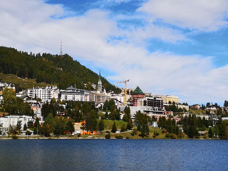
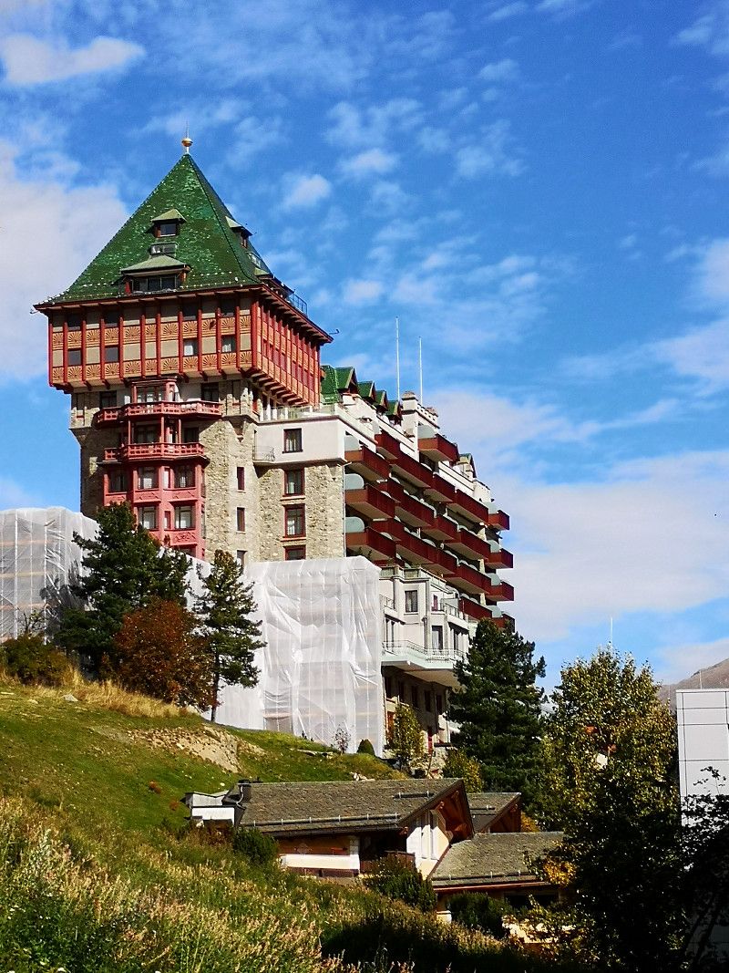
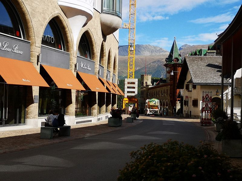
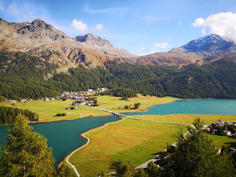
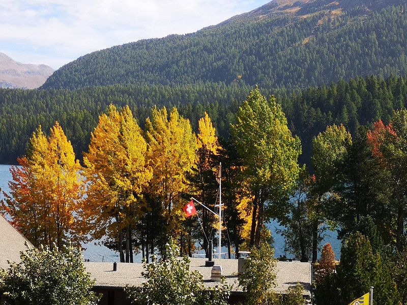
Sankt Moritz
Great campsite right on Lake Silvaplana
Maloja, Graubünden, Schweiz
46° 29' 52.4" N 9° 50' 21.3" E
46.4978958 9.8392428
• Head toward Via dal Mulin. Go for 26 m.
• Turn right onto Via dal Mulin. Go for 37 m.
• Turn right onto Via Traunter Plazzas. Go for 58 m.
• Turn left onto Via dal Mulin. Go for 56 m.
• Continue on Via Traunter Plazzas. Go for 128 m.
• Take the 1st exit from Plazza da la Posta Veglia roundabout onto Via Somplaz. Go for 3.2 km.
• Continue on Via Maistra Champfèr. Go for 54 m.
• Continue on Plazza Guardalej. Go for 10 m.
• Continue on Via Maistra Champfèr. Go for 599 m.
• Turn right onto Via Chantunela (27). Go for 695 m.
• Take the 2nd exit from roundabout onto Sviamaint da Silvaplauna (3) toward Chur/Julierpass. Go for 43.0 km.
• Take the 2nd exit from roundabout onto Albulastrasse (3/417) toward Chur/Thusis/Lenzerheide. Go for 10.4 km.
• Continue on Tunnel Sils. Go for 1.8 km.
• Take ramp onto A13 toward Chur. Go for 48.8 km.
• Take exit 11 toward St. Gallen/St. Margrethen/München/Feldkirch/Vaduz onto A13. Go for 40.8 km.
• Take exit 4 toward Kriessern/Altstätten/Götzis. Go for 389 m.
• Continue on Zollstrasse. Go for 260 m.
• Continue on L58. Go for 429 m.
• Take the 3rd exit from roundabout onto Mäderer Landesstraße (L58). Go for 1.2 km.
• Take the 3rd exit from roundabout onto Neue Landstraße (L55). Go for 951 m.
• Take left ramp onto A14 (Rheintal Autobahn) toward Deutschland/Bregenz. Go for 26.5 km.
• Continue on A96. Go for 39.0 km.
• Take exit 8 toward Leutkirch-Süd/Herlazhofen. Go for 353 m.
• Turn right onto Zollhaus (K8025) toward Leutkirch/Isny/Herlazhofen. Go for 1.3 km.
• Continue on Wangener Straße (K8025). Go for 1.1 km.
• Take the 1st exit from roundabout onto Wangener Straße (L308). Go for 180 m.
• Turn left onto Untere Grabenstraße (L260). Go for 292 m.
• Enter the roundabout. Go for 33 m.
• Arrive at your destination on the left.
☍
221,6 km
(2 hrs. 39 min.)
Day
Leutkirch im Allgäu
Deutschland
47° 49' 36.3" N 10° 1' 17" E
47.8267410 10.0213851
• Follow the roundabout. Go for 18 m.
• Take the 2nd exit from roundabout onto Bahnhofstraße. Go for 137 m.
• Turn left onto Karlstraße (L308). Go for 106 m.
• Continue on Poststraße (L308). Go for 232 m.
• Take the 1st exit from roundabout onto Wangener Straße (K8025). Go for 1.1 km.
• Continue on Wangener Straße (K8025). Go for 1.7 km.
• Turn left and take ramp onto A96 toward Lindau/Wangen. Go for 35.2 km.
• Take exit 3 toward Sigmarszell/Scheidegg/Flughafen Friedrichshafen. Go for 329 m.
• Turn right onto B31 toward Flughafen Friedrichshafen/Lindau/Ravensburg/B467. Go for 35.7 km.
• Continue on B31 toward Donaueschingen/Meersburg. Go for 4.9 km.
• Keep left onto B31 toward Stuttgart/Singen/Stockach/Überlingen/Uhldingen-Mühlhofen. Go for 12.6 km.
• Continue on B31N. Go for 15.6 km.
• Continue on A98. Go for 12.5 km.
• Take exit 11 toward Stuttgart/Villingen-Schwenningen onto A81. Go for 42.9 km.
• Take exit 35 toward Rottweil-Süd/Deißlingen onto B27. Go for 7.5 km.
• Take the 1st exit from roundabout onto B14/B27 toward Stuttgart/A81/Tübingen/Balingen/Schramberg/Oberndorf a.N./RW-Bühlingen/Gewerbegebiet Zimmern o.R./Gewerbegebiet Berner Feld/Gewerbegebiet Neckartal. Go for 1.3 km.
• Take ramp toward RW-Bühlingen. Go for 259 m.
• Turn right onto Stadionstraße. Go for 1.2 km.
• Take the 2nd exit from roundabout onto Stadionstraße toward Stadtmitte. Go for 274 m.
• Take the 2nd exit from roundabout onto Königstraße toward Stadtmitte. Go for 499 m.
• Arrive at Königstraße. Your destination is on the right.
☍
174,1 km
(2 hrs. 1 min.)
Day
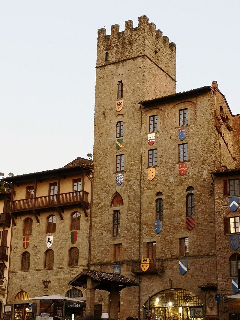
Rottweil, Deutschland
48° 9' 54.9" N 8° 37' 42.4" E
48.1652577 8.6284530