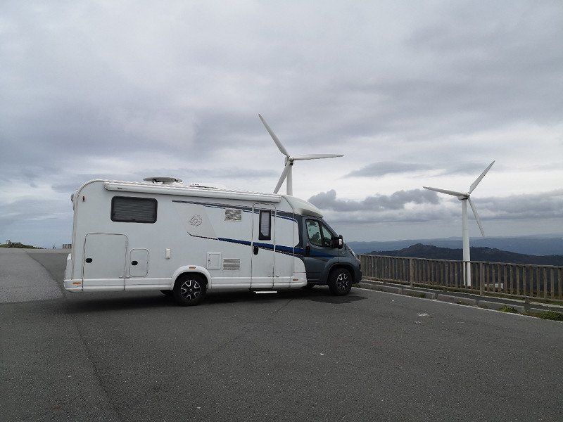
Day
Rottweil, Deutschland
48° 9' 54.9" N 8° 37' 42.4" E
48.1652577 8.6284530
• Head toward Wilhelmstraße on Königstraße. Go for 447 m.
• Take the 2nd exit from roundabout onto Königstraße. Go for 668 m.
• Continue on Tuttlinger Straße. Go for 2.0 km.
• Take the 2nd exit from roundabout onto B27. Go for 16.3 km.
• Continue toward Schaffhausen/Donaueschingen/Bad Dürrheim. Go for 56 m.
• Turn slightly left onto B27/B33. Go for 23.4 km.
• Take the 2nd exit from roundabout onto Schaffhauser Straße (B27) toward Schaffhausen/Waldshut-Tiengen/Gewerbegebiet Vogelherd. Go for 230 m.
• Turn right onto Waldshuter Straße (L214) toward Fützen/Epfenhofen/Gewerbegebiet Vogelherd. Go for 755 m.
• Take the 2nd exit from roundabout onto Waldshuter Straße (L214). Go for 326 m.
• Continue on L214. Go for 1.6 km.
• Take ramp onto B314 toward Waldshut-Tiengen. Go for 27.9 km.
• Take the 1st exit from roundabout onto A98 toward Schaffhausen/B34/Klettgau. Go for 352 m.
• Continue on B34. Go for 2.8 km.
• Turn right onto L162 toward Zurzach/Küssaberg. Go for 5.1 km.
• Take the 2nd exit from roundabout onto Zurzacher Straße (L162). Go for 592 m.
• Continue toward Zürcherstrasse. Go for 59 m.
• Continue on Zürcherstrasse. Go for 27 m.
• Turn right onto Zürcherstrasse. Go for 176 m.
• Turn left onto Ostumfahrung Zurzach. Go for 720 m.
• Continue on Bruggerstrasse. Go for 1.6 km.
• Continue on Zurzibergstrasse. Go for 1.4 km.
• Take the 2nd exit from roundabout onto Zurzibergstrasse. Go for 544 m.
• Turn right onto Staltig. Go for 225 m.
• Continue on Steig. Go for 262 m.
• Continue on Würenlingerstrasse. Go for 2.9 km.
• Continue on Tegerfelderstrasse. Go for 1.4 km.
• Continue on Breitenstrasse. Go for 860 m.
• Continue on Siggenthalerstrasse. Go for 180 m.
• Take the 2nd exit from roundabout onto Siggenthalerstrasse. Go for 699 m.
• Turn left onto Döttingerstrasse (5). Go for 386 m.
• Turn right onto Stillistrasse (5) toward Bern/Luzern/Aarau/Brugg/Hard. Go for 2.8 km.
• Take the 2nd exit from roundabout onto Zurzacherstrasse (5). Go for 2.0 km.
• Turn left onto Aarauerstrasse (3/5). Go for 491 m.
• Continue on Aarauerstrasse (5). Go for 972 m.
• Turn left onto Unterwerkstrasse. Go for 116 m.
• Keep right onto Unterwerkstrasse. Go for 123 m.
• Turn left onto Unterwerkstrasse. Go for 118 m.
• Take the 3rd exit from roundabout toward Windisch/Hausen. Go for 958 m.
• Continue on Zubringer Hausen. Go for 1.8 km.
• Continue on Lenzburgerstrasse. Go for 3.4 km.
• Take the 3rd exit from roundabout onto A1 toward Bern. Go for 37.2 km.
• Continue on A1 (Härkingen) toward E25/Lausanne/Bern/Biel/Bienne/Oensingen. Go for 50.8 km.
• Continue on A6 (Wankdorf) toward Interlaken/Thun/Bern-Ostring/Bern-Wankdorf/Flughafen. Go for 3.6 km.
• Take exit 12 toward Bern-Ostring. Go for 252 m.
• Continue on Ostring (6) toward Lausanne/Fribourg/Zentrum. Go for 563 m.
• Take the 2nd exit from roundabout onto Thunstrasse (10) toward Lausanne/Fribourg. Go for 621 m.
• Take the 2nd exit from Thunplatz roundabout onto Jungfraustrasse. Go for 464 m.
• Continue on Marienstrasse. Go for 447 m.
• Turn right onto Kirchenfeldbrücke. Go for 253 m.
• Continue on Casinoplatz. Go for 101 m.
• Continue on Hotelgasse. Go for 73 m.
• Arrive at Hotelgasse. Your destination is on the left.
☍
201,0 km
(2 hrs. 25 min.)
Bern
Schweiz
46° 56' 52.7" N 7° 26' 50.8" E
46.9479739 7.4474468
• Head toward Kramgasse on Hotelgasse. Go for 5 m.
• Continue on Zibelegässli. Go for 58 m.
• Turn left onto Rathausgasse. Go for 53 m.
• Turn right onto Kornhausplatz. Go for 31 m.
• Turn right onto Grabenpromenade. Go for 92 m.
• Turn left onto Brunngasshalde. Go for 55 m.
• Continue on Schüttestrasse. Go for 254 m.
• Continue on Waisenhausplatz. Go for 43 m.
• Continue on Hodlerstrasse. Go for 296 m.
• Continue on Schützenmattstrasse (1/12). Go for 250 m.
• Turn right onto Neubrückstrasse (1/12) toward Zürich/Basel/6/Biel. Go for 66 m.
• Turn right onto Tiefenaustrasse (1/12). Go for 804 m.
• Keep left toward Neufeldtunnel. Go for 212 m.
• Continue on Neufeldtunnel. Go for 559 m.
• Take left ramp onto A1 toward Lausanne/Neuchâtel/Fribourg. Go for 97.0 km.
• Continue on A1. Go for 2.7 km.
• Take the exit toward Genève onto A1. Go for 65.2 km.
• Continue on A41. Go for 1.1 km.
• Take the exit toward Paris/Lyon onto A40 (Autoroute Blanche). Go for 77.8 km.
• Take the exit toward Lyon/Aéroport Saint Exupéry onto A42. Go for 48.6 km.
• Take the left exit toward Marseille/Grenoble/Lyon/N346 onto A42. Go for 990 m.
• Take the exit toward Lyon onto A42. Go for 3.6 km.
• Take the left exit toward Marseille/Grenoble/Périphérique Sud/Porte de Cusset onto D383 (Boulevard Laurent Bonnevay). Go for 6.0 km.
• Keep left onto Boulevard Laurent Bonnevay (D383) toward St Étienne/Marseille/Vénissieux. Go for 1.9 km.
• Keep left onto Boulevard Laurent Bonnevay (D383) toward Paris/Saint-Étienne/Marseille/Lyon-Centre/Vénissieux-Centre. Go for 3.3 km.
• Keep left onto D383 toward Paris/Marseille/Saint-Étienne/Pierre Bénite/Saint Fons-Centre/Port E. Herriot. Go for 2.3 km.
• Take ramp toward Saint Fons-Belle Étoile. Go for 263 m.
• Continue on Avenue Albert Ramboz. Go for 1.3 km.
• Take the 3rd exit from roundabout onto Avenue Albert Ramboz. Go for 782 m.
• Take ramp onto A7 (Autoroute du Soleil) toward Vienne/St Étienne/Valence/Marseille. Go for 22.8 km.
• Take exit 10 toward Ampuis/Condrieu onto D386. Go for 1.7 km.
• Turn left onto D4 G toward D45 E/Marseille/Vaugris/Z.A. de Vérenay. Go for 781 m.
• Turn right onto Route du Barrage (D4 B). Go for 384 m.
• Turn left onto Route du Barrage (D4). Go for 360 m.
• Turn right onto N7. Go for 2.2 km.
• Take the 3rd exit from roundabout onto Chemin du Pavillon (D131) toward Reventin-Village/Les Côtes d'Arey. Go for 279 m.
• Continue on Route des Côtes d'Arey (D131). Go for 919 m.
• Turn left onto Chemin des Cîmes (C4). Go for 527 m.
• Turn left onto Rue de la Mairie. Go for 267 m.
• Continue on Rue des Écoles. Go for 52 m.
• Continue on Rue Mouret. Go for 62 m.
• Turn slightly left onto Rue des Écoles. Go for 10 m.
• Arrive at Rue des Écoles. Your destination is on the left.
☍
346,1 km
(3 hrs. 20 min.)
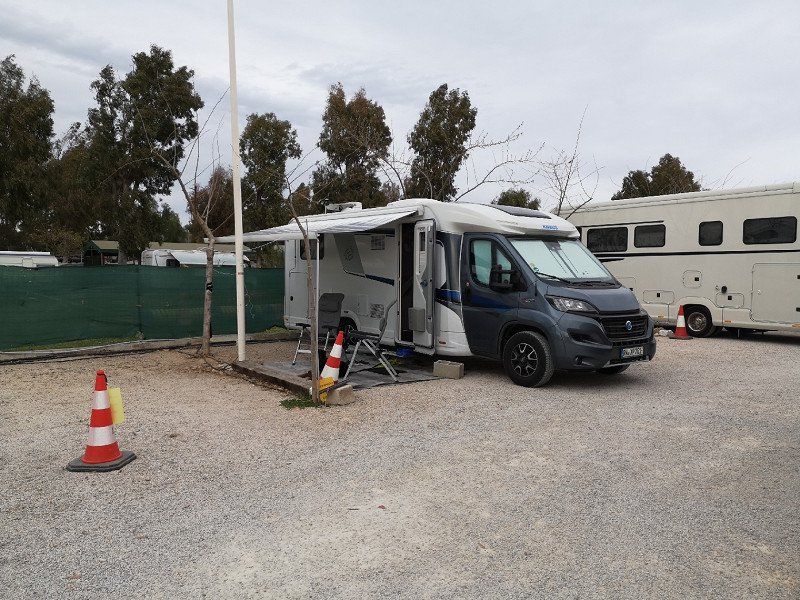
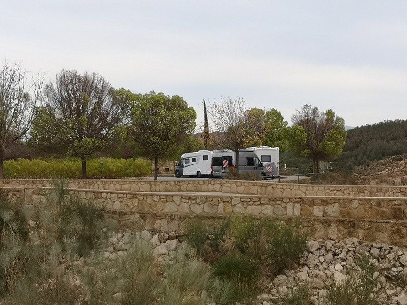
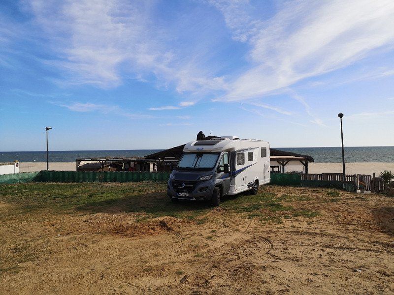
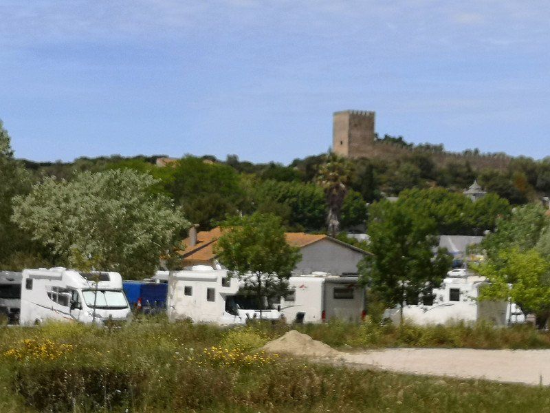
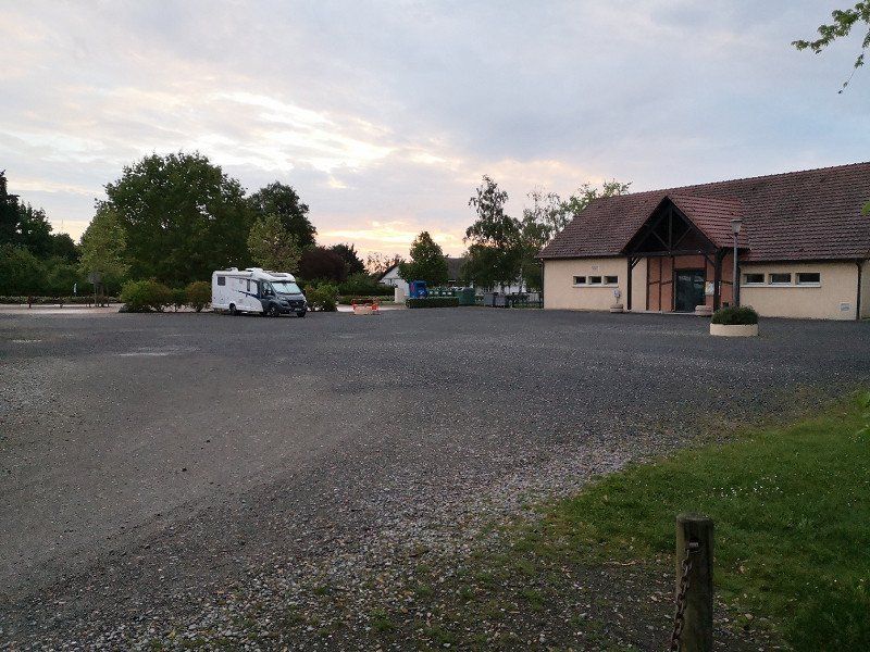
Wohnmobilstellplatz
Beautiful parking lot with water, toilet, waste disposal, disposal option. Next door a bakery.
Parking is known and therefore well frequented.
93 Rue des Écoles, 38121 Reventin-Vaugris, Frankreich
45° 28' 7.4" N 4° 50' 31.2" E
45.4687223 4.8419962
• Head toward Rue Mouret on Rue des Écoles. Go for 10 m.
• Turn slightly right onto Rue Mouret. Go for 62 m.
• Continue on Rue des Écoles. Go for 52 m.
• Turn right onto Chemin des Petrières (C1). Go for 833 m.
• Continue on Chemin des Petrières (C1). Go for 115 m.
• Turn right onto Route des Côtes d'Arey (D131). Go for 133 m.
• Continue on Chemin du Pavillon (D131). Go for 235 m.
• Take the 3rd exit from roundabout onto N7 toward Valence/Roussillon/Auberives S/V./Z.A. du Saluant. Go for 1.5 km.
• Pass 2 roundabouts and continue on N7. Go for 7.9 km.
• Take left ramp onto A7 (Autoroute du Soleil) toward Annonay/Valence. Go for 150 km.
• Keep right onto A9 (Échangeur d'Orange) toward Barcelone/Toulouse/Montpellier/Nîmes. Go for 281 km.
• Continue on AP-7 (Autopista de la Mediterrània). Go for 66.6 km.
• Take the exit toward Fornells de la Selva/Barcelona/N-2 onto A-2 (Autovia del Nordest). Go for 28.1 km.
• Take the 3rd exit from roundabout onto GI-600 toward Blanes. Go for 1.9 km.
• Take the 1st exit from roundabout onto C-32 toward Barcelona. Go for 25.8 km.
• Take exit 108 toward Caldes d'Estrac. Go for 403 m.
• Take the 4th exit from roundabout onto BV-5034 toward Caldes d'Estrac. Go for 475 m.
• Take the 2nd exit from roundabout onto BV-5034 toward Barcelona/N-2/Girona. Go for 765 m.
• Turn right onto N-2 toward Mataró/Barcelona. Go for 796 m.
• Take the 3rd exit from roundabout onto N-2 toward Barcelona. Go for 2.2 km.
• Take the 2nd exit from roundabout toward Barcelona. Go for 83 m.
• Continue on N-2. Go for 565 m.
• Turn right. Go for 124 m.
• Arrive at your destination on the left.
☍
569,8 km
(5 hrs. 7 min.)
Day
Camping Barcelona
camping barcelona,
Not a really nice campsite, a bit too noisy because of the railway and road, but it offers a cheap (€3.9 per trip) bus service to Barcelona (approx. 40 minutes, 39 km). Important: book online as soon as possible (https://campingbarcelonabus.com/bus-tickets/)
Veinat de Mata, 108, 08304 Mataró, Barcelona, Spanien
41° 33' 4.9" N 2° 28' 58.9" E
41.5513700 2.4830199
• Head southeast. Go for 84 m.
• Continue toward Avinguda del Maresme/N-2. Go for 36 m.
• Turn right onto Avinguda del Maresme (N-2). Go for 611 m.
• Take the 1st exit from Rotonda d'Elisabet Cristina de Brunsvic roundabout onto Carretera de la Pedrera (C-31E) toward C-32/N-2/Barcelona. Go for 1.4 km.
• Take ramp onto C-32 (Autopista de Barcelona a Mataró) toward Barcelona/N-2/Mataró. Go for 19.6 km.
• Keep right onto C-31 toward Barcelona/Glòries/Tiana/Montgat. Go for 12.8 km.
• Turn right onto Carrer de Padilla. Go for 180 m.
• Turn left onto Avinguda Diagonal toward C. Lepant/pl. Francesc Macià/Estació Sants/Aeroport. Go for 391 m.
• Turn slightly left onto Carrer d'Aragó toward Pl. Espanya/Estació Sants/Aeroport. Go for 1.5 km.
• Turn left onto Passeig de Gràcia. Go for 447 m.
• Turn right onto Passeig de Gràcia. Go for 200 m.
• Turn right onto Plaça de Catalunya. Go for 141 m.
• Arrive at Plaça de Catalunya. Your destination is on the left.
☍
37,3 km
( 35 min.)
Day
Barcelona, Spanien
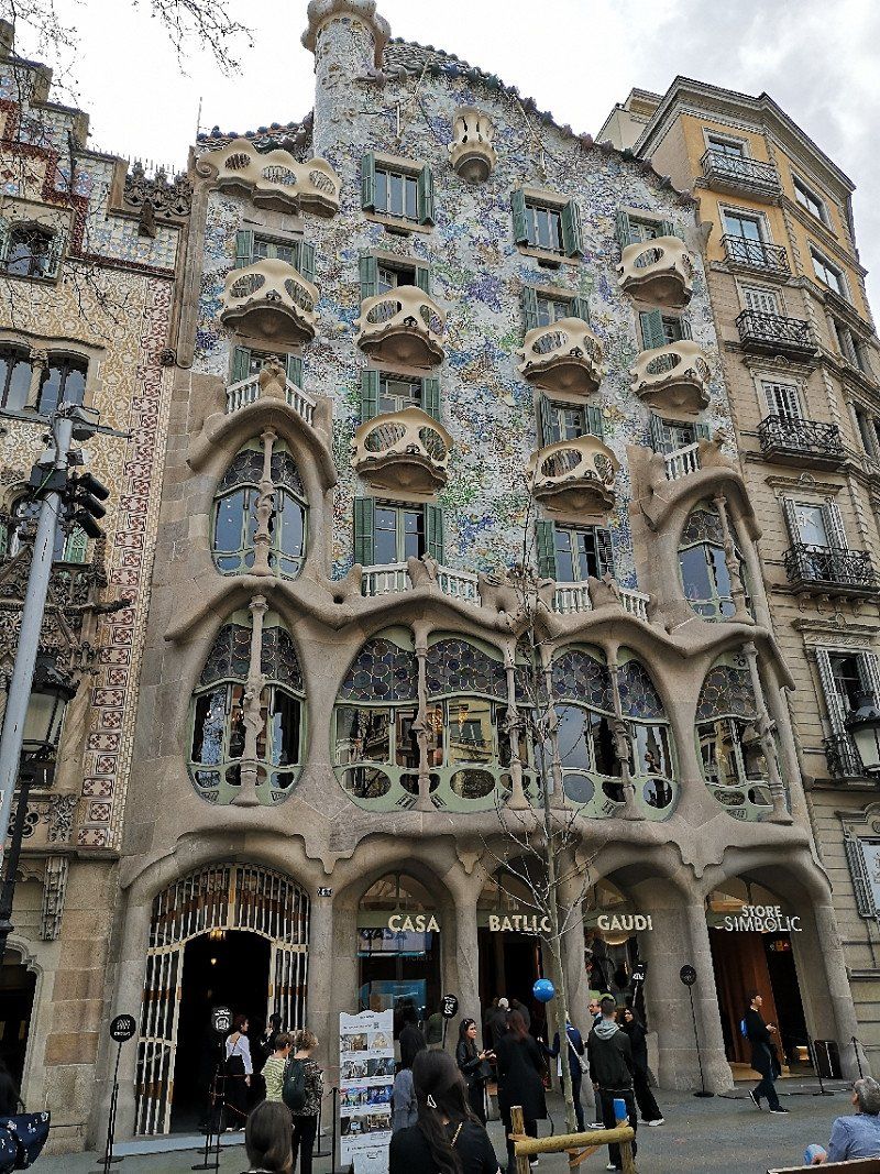
The city of Barcelona captivates with numerous Gothic architecture and is therefore characterized by its special originality. The most impressive house in the metropolis in Spanish Art Nouveau style is Antoni Gaudí's Casa Batlló. It's worth taking a look from the outside alone, you can hardly miss the house when strolling through the city!
Information and tips:
Location: Passeig de Gràcia 43, 08007 Barcelona
Opening times: daily 9 a.m. - 9 p.m. (last entry 8 p.m.)
Prices:
Adults €24.50
7-18 years, students and seniors €21.50
Children under 7 years free of charge
The architectural work is also called "House of Bones" because of the balconies, which are reminiscent of skull parts and bones. The roof resembles the scaly skin of an animal, the sun lets the colorfully mixed mosaics and tiles shimmer and shine in the sunlight. The inner workings of Casa Batlló fascinate with artful details, no matter where you look. Simply fascinating how Gaudí implemented colors, shapes and lights in all his masterpieces.
Guru tip: If you want to explore the Catalan city and are just as excited as I am, you should also visit Gaudí's Park Güell. The park's greenery seems to have sprung from an enchanting fairy tale - extraordinary architectural forms decorated with small colorful mosaics. A feast for the eyes! Barcelona really is a creative paradise, don't you agree?
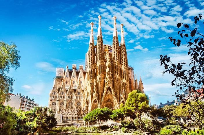
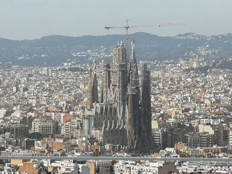
Sagrada Família in Barcelona
I assume that you certainly know this pompous building and that it can rightly be named first. The Sagrada Familia is the symbol of the cosmopolitan city of Barcelona and is admired by millions of international visitors every day.
Information and tips:
Location: Carrer de Mallorca/Carrer de Marina, 08013 Barcelona
Opening hours:
Nov-Feb 9am-6pm
Mar 9am-7pm
Apr-Sept 9am-8pm
Oct 9am-7pm
Prices:
Church: 15€ (can only be purchased online)
Church & audio guide: 22€
Church, museum & audio guide: 24€
Church & guided tour: 24€
Church, tower visit & audio guide: 29€
The gigantic church was designed by Antoni Gaudí and construction began in 1882. Unfortunately, these continue to this day, so when you visit this attraction in Spain you will certainly notice the numerous scaffolding. This total work of art has been in the works for 136 years, but there is great hope that it will be completed by 2026, on the occasion of the 100th anniversary of Gaudí's death, and that the church can finally shine as a whole. The architecture of the Sagrada Familia is particularly striking, be it from the outside or inside. Until the construction is completed, the church will be framed from the outside by a total of 18 detailed towers with filigree and colorful tips.
The tallest tower of the Sagrada Familia is said to be a proud 172.5 meters high, making it the tallest church tower in the world. The pillars that stand in the interior and make it look even higher stand for religious symbolism. Each column is special in a way and is reminiscent of a tree trunk with branches. If you look up, you'll see what I'm talking about: a forest of lights falling through the stained glass windows and unique shapes line the entire nave. Simply indescribable - just take a look for yourself during your holiday in Barcelona!
Guru Tip: The line of tourists waiting in front of the Sagrada Familia is endless, so I recommend buying your tickets online in advance. You can choose between normal single tickets or tickets including interesting audio guides, a guided tour or a visit to the Gaudí House Museum.
By the way: You can find more Barcelona tips in my travel magazine.
The high-rise Mirador Terre Glories has a viewing platform from which you can admire the whole of Barcelona, highly recommended. Admission €15 per person when booked online.
We recommend the hop on/hop off bus tour for €33 per person.
Barcelona, Provinz Barcelona, Spanien
41° 23' 14.6" N 2° 10' 6.8" E
41.3873974 2.1685680
• Head southwest on Plaça de Catalunya.
• Continue on Ronda de la Universitat. Go for 365 m.
• Continue on Plaça de la Universitat toward Pl. Universitat/G. V. Corts Catalanes/Pl. Espanya/Rda. Sant Antoni. Go for 97 m.
• Continue on Ronda de Sant Antoni. Go for 124 m.
• Turn right onto Plaça de Goya. Go for 69 m.
• Continue on Carrer de Sepúlveda. Go for 1.4 km.
• Turn right onto Avinguda del Paral.lel. Go for 168 m.
• Take the 4th exit from Plaça d'Espanya roundabout onto Gran Via de les Corts Catalanes toward pl. Cerdà/Aeroport/Castelldefels/C-31/C-32/Fira Gran Via/l'Hospitalet/Tarragona. Go for 5.2 km.
• Take exit 195A toward Tarragona onto B-20. Go for 4.8 km.
• Continue on C-32. Go for 54.5 km.
• Take the left exit toward Tarragona/València onto AP-7 (Autopista de la Mediterrània). Go for 12.2 km.
• Take exit 32 toward Torredembarra/Altafulla. Go for 460 m.
• Take the 3rd exit from roundabout onto T-214 toward AP-7/Lleida/Torredembarra/Altafulla/Tarragona/Barcelona. Go for 226 m.
• Take the 1st exit from roundabout onto Carretera de Cádiz a Barcelona (N-340) toward Tarragona. Go for 4.9 km.
• Continue on A-7. Go for 7.4 km.
• Take exit 1164 toward Centre Ciutat Tarragona/Vía Augusta. Go for 344 m.
• Take the 4th exit from roundabout. Go for 180 m.
• Take the 1st exit from roundabout onto Carretera Llorito toward Centre Ciutat Tarragona. Go for 907 m.
• Continue toward Tarragona Centre Cuitat/Augusta. Go for 46 m.
• Take the 1st exit from roundabout onto Carrer de la Via Augusta toward Tarragona Centre Cuitat/Augusta. Go for 281 m.
• Pass 2 roundabouts and continue on Carrer de la Via Augusta (N-340). Go for 1.1 km.
• Turn left onto Passeig Marítim de Rafael Casanova. Go for 198 m.
• Turn right onto Passeig Marítim de Rafael Casanova. Go for 305 m.
• Turn left. Go for 14 m.
• Arrive at your destination on the left.
☍
95,3 km
(1 hrs. 10 min.)
Day
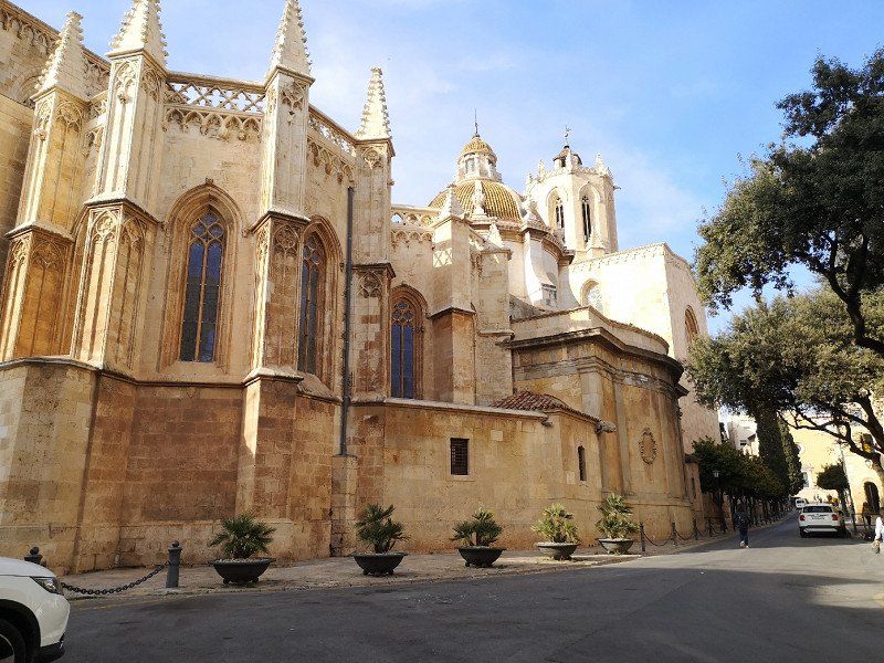
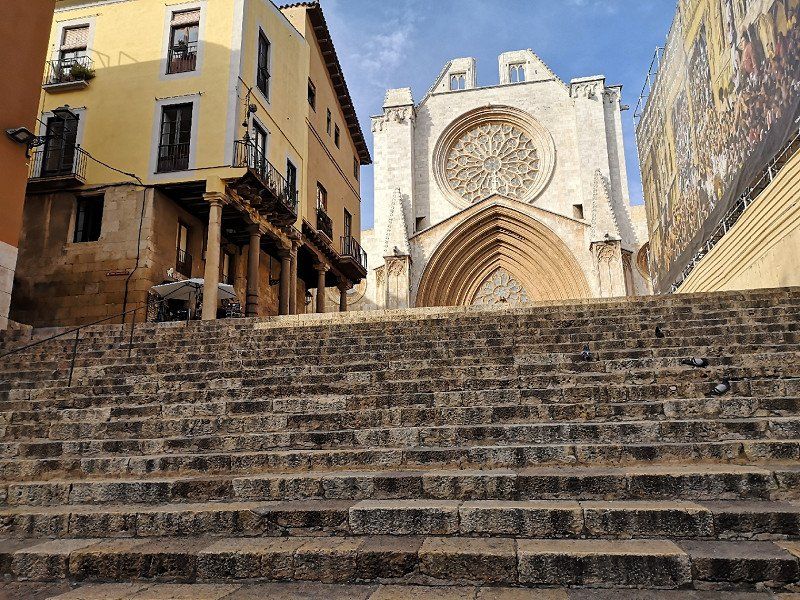
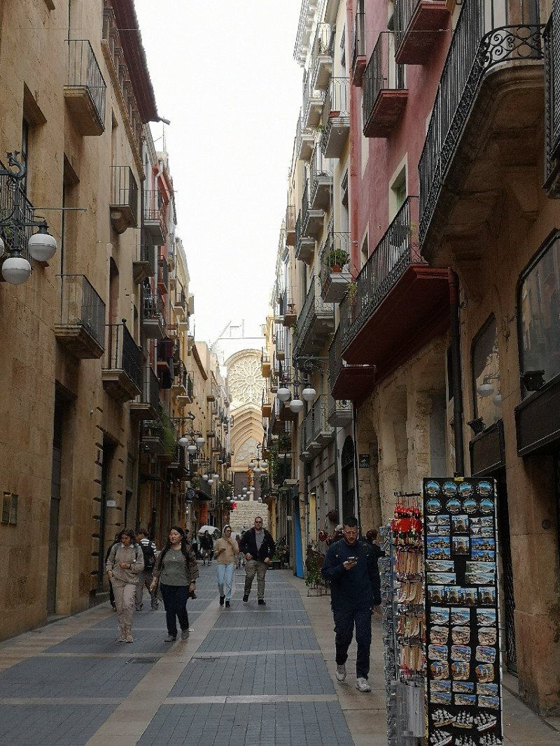
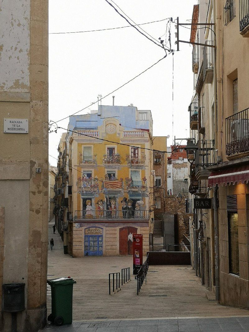
Tarragona
On the C31 via the beautiful coastal road to Sitges and on to Tarragona, which has a beautiful old town.
Passeig Marítim Rafael Casanov, 6B, 43007 Tarragona, Spanien
41° 6' 49.1" N 1° 15' 58.7" E
41.1136454 1.2663108
• Head toward Passeig Marítim de Rafael Casanova. Go for 14 m.
• Turn right onto Passeig Marítim de Rafael Casanova. Go for 305 m.
• Turn left onto Passeig Marítim de Rafael Casanova. Go for 198 m.
• Turn right onto Carrer de la Via Augusta (N-340). Go for 432 m.
• Pass 2 roundabouts and continue on Carrer de la Via Augusta (N-340). Go for 855 m.
• Continue toward Carretera Llorito. Go for 44 m.
• Take the 2nd exit from roundabout onto Carretera Llorito toward Castelló/A-7/Barcelona. Go for 988 m.
• Take the 2nd exit from roundabout. Go for 156 m.
• Take the 3rd exit from roundabout onto A-7 (Autopista de Circumval.lació) toward Tarragona/Castello. Go for 13.2 km.
• Take exit 1152 toward Vila-Seca oest/E-15/Reus/C-14/Salou/Tarragona/Castelló onto AP-7 (Autopista de la Mediterrània). Go for 111 km.
• Take exit 43 toward Peníscola/Peñíscola/Benicarló. Go for 1.2 km.
• Turn right. Go for 24 m.
• Turn right. Go for 442 m.
• Turn left toward Avenida de la Estación/CV-141. Go for 600 m.
• Turn left onto Avenida de la Estación (CV-141). Go for 2.2 km.
• Take the 2nd exit from roundabout onto Avenida de la Estación (CV-141). Go for 1.3 km.
• Take the 1st exit from roundabout. Go for 221 m.
• Arrive at your destination on the right.
☍
133,5 km
(1 hrs. 22 min.)
Day
Day
Peníscola
Spanien
40° 22' 0.8" N 0° 23' 28.7" E
40.3668829 0.3913172
• Head north. Go for 168 m.
• Take the 4th exit from roundabout onto Avenida de la Estación (CV-141) toward E-15/AP-7/Castelló/Tarragona. Go for 1.4 km.
• Take the 3rd exit from roundabout onto Avenida de la Estación (CV-141). Go for 3.6 km.
• Continue on CV-141 toward Benicarló/Tarragona/E-15/AP-7/Valencia/Barcelona. Go for 70 m.
• Take the 2nd exit from roundabout onto N-340 toward Benicarló/Tarragona/E-15/AP-7/Valencia/Barcelona. Go for 1.8 km.
• Take ramp toward N-340a/Benicarló sud/Benicarló Sur/Castelló/Castellón/E-15/AP-7/Tarragona. Go for 332 m.
• Take the 1st exit from roundabout onto AP-7 (Autopista del Mediterráneo) toward Valencia. Go for 115 km.
• Keep left onto V-21 toward Valencia (Norte)/Puçol/V-23/Sagunt/Sagunto. Go for 19.6 km.
• Take the 2nd exit from Plaza Cardenal Vicente Enrique y Tarancón roundabout onto Avenida de Aragón toward Estadi Mestalla/Av. Aragón/Av. d'Aragó/Grans Víes. Go for 749 m.
• Take the 2nd exit from roundabout onto Avenida de Aragón. Go for 209 m.
• Take the 3rd exit from Plaza Zaragoza roundabout. Go for 90 m.
• Continue on Puente de Aragón. Go for 208 m.
• Continue toward Avenida Jacinto Benavente. Go for 48 m.
• Turn left onto Avenida Jacinto Benavente toward Alicante/Alacant/Madrid/A-3/Ciudad de las Artes y Las Ciencias/El Saler. Go for 719 m.
• Continue on Calle del Alcalde Reig toward Ciudad de las Artes y Las Ciencias/El Saler. Go for 532 m.
• Take the 2nd exit from roundabout onto Avenida Profesor López Piñero (V-15) toward Madrid/Aeropuerto/A-3/Hospital La Fe/Ciutat de les Arts i les Ciències. Go for 107 m.
• Keep left onto Avenida Profesor López Piñero (V-15). Go for 3.4 km.
• Continue on CV-500. Go for 4.2 km.
• Take the exit toward El Saler. Go for 1.0 km.
• Take the 1st exit from roundabout toward El Saler. Go for 66 m.
• Continue on Carrera del Río (CV-5010). Go for 100 m.
• Turn right. Go for 58 m.
• Turn left. Go for 100 m.
• Arrive at your destination on the left.
☍
153,7 km
(1 hrs. 33 min.)
Camping Bungalow Park Albufeira
Directly at a bus stop, every 20 minutes there is a bus to Valencia
Carrera del Riu, 556, 46012 Valencia, Spanien
39° 23' 13.6" N 0° 20' 0.2" W
39.3871091 -0.3333766
• Head east. Go for 100 m.
• Turn right toward Carrera del Río/CV-5010. Go for 58 m.
• Turn left onto Carrera del Río (CV-5010). Go for 140 m.
• Take the 3rd exit from roundabout onto CV-500 toward Valencia. Go for 5.2 km.
• Continue on V-15. Go for 3.4 km.
• Take the 1st exit from roundabout onto Calle del Alcalde Reig toward Centre Ciutat. Go for 614 m.
• Continue on Avenida Jacinto Benavente toward Centro Ciudad/Centre Ciutat. Go for 684 m.
• Turn left onto Gran Vía Marqués del Turia. Go for 517 m.
• Turn right onto Calle Isabel la Católica. Go for 348 m.
• Turn slightly left onto Calle Pérez Bayer. Go for 116 m.
• Continue on Plaza Niños de San Vicente. Go for 30 m.
• Continue on Calle Sagasta. Go for 92 m.
• Continue on Calle Correos. Go for 174 m.
• Arrive at Calle Correos. Your destination is on the right.
☍
11,5 km
( 13 min.)
Day
Valencia
Beautiful old town easily explored on foot
Spanien
39° 28' 11.7" N 0° 22' 34.6" W
39.4699075 -0.3762881
• Head toward Calle Pérez Pujol on Calle Correos. Go for 89 m.
• Turn right onto Calle Pérez Pujol. Go for 73 m.
• Turn left onto Calle Roger de Lauria. Go for 81 m.
• Turn right onto Calle Pascual y Genís. Go for 143 m.
• Continue on Calle Félix Pizcueta. Go for 272 m.
• Turn right onto Gran Vía Marqués del Turia. Go for 157 m.
• Continue on Gran Vía de las Germanías toward Aeropuerto/Madrid/A-3/CV-35/Llíria/V-31/Alacant/Albacete. Go for 243 m.
• Keep right onto Gran Vía de las Germanías toward Alacant/V-31/Albacete/València Joaquín Sorolla. Go for 164 m.
• Turn left onto Calle de Gibraltar. Go for 34 m.
• Turn slightly right onto Calle Cuba. Go for 253 m.
• Turn right onto Calle Puerto Rico. Go for 167 m.
• Turn right onto Calle Filipinas. Go for 82 m.
• Make a U-Turn onto Calle Filipinas. Go for 506 m.
• Continue on Plaza de Manuel Sanchis Guarner. Go for 69 m.
• Turn right onto Avenida de Ausiàs March. Go for 1.3 km.
• Take the 3rd exit from roundabout onto Avenida de Ausiàs March (V-31) toward V-30/Hospital La Fe/Hospital Urgències/Urgencias. Go for 13.8 km.
• Continue on A-7 (Autovía del Mediterráneo). Go for 42.8 km.
• Continue on A-35 toward Albacete/Murcia. Go for 32.8 km.
• Take exit 11 toward La Font de la Figuera/Alacant/Alicante/Murcia onto A-33. Go for 92.9 km.
• Continue on A-30 (Autovía de Murcia). Go for 22.5 km.
• Take exit 134A toward Murcia/Ronda Oeste/Cartagena/E-15/Almería/A-7 onto A-30 (Murcia Ronda Oeste). Go for 3.0 km.
• Take exit 138 toward Almería/Granada onto A-7 (Autovía del Mediterráneo). Go for 193 km.
• Take exit 762 toward Hospital/Retamar-El Toyo/AL-3115/Cabo de Gata onto N-344. Go for 4.5 km.
• Take the 2nd exit from roundabout onto Carretera Níjar-Retamar (N-344) toward Almería/AL-12. Go for 565 m.
• Take the 3rd exit from roundabout onto Carretera de Cabo de Gata (AL-3115) toward El Toyo/Plaza del Mar/Retamar/Cabo de Gata/San Jose. Go for 528 m.
• Take the 2nd exit from roundabout onto Carretera de Cabo de Gata (AL-3115). Go for 749 m.
• Take the 3rd exit from roundabout toward Cabo de Gata/San Jose. Go for 114 m.
• Continue on Carretera de Cabo de Gata (AL-3115). Go for 7.2 km.
• Take the 1st exit from roundabout onto Carretera de Cabo de Gata (AL-3115) toward Cabo de Gata. Go for 2.0 km.
• Continue on AL-3115. Go for 259 m.
• Continue on Carretera de Cabo de Gata (AL-3115). Go for 2.6 km.
• Continue on AL-3115. Go for 509 m.
• Take the 1st exit from roundabout onto Calle Mazarulleque. Go for 138 m.
• Arrive at Calle Mazarulleque. Your destination is on the left.
☍
423,4 km
(4 hrs. 3 min.)
Day
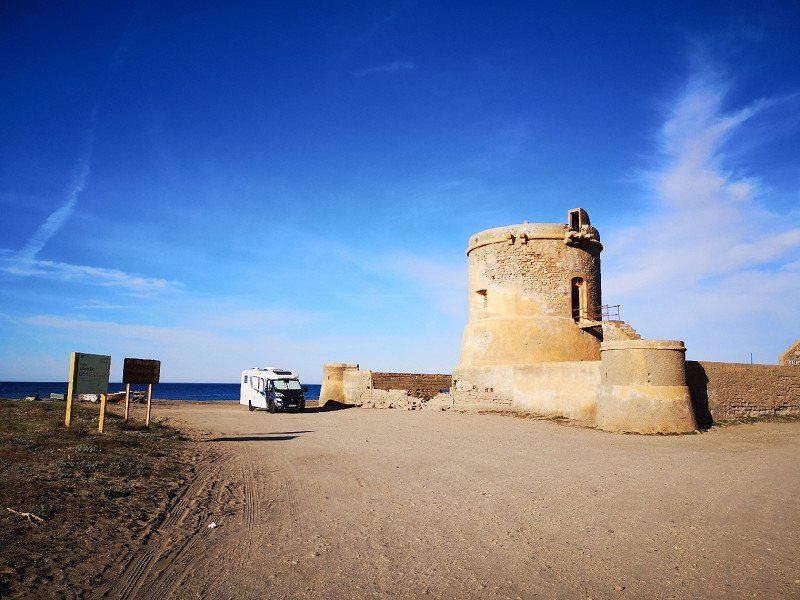
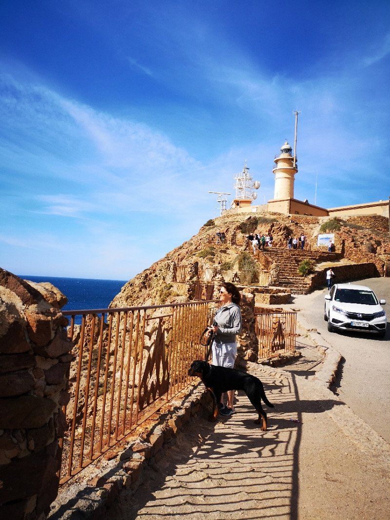
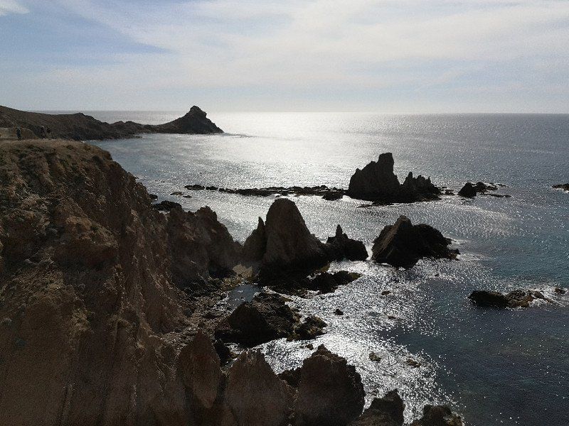
Cabo de Gata
Overnight on the beach next to Torreon de San Miguel
Spanien
36° 46' 54.3" N 2° 14' 32.1" W
36.7817465 -2.2422484
• Head northwest on Calle Mazarulleque. Go for 175 m.
• Turn right onto Calle El Salmón. Go for 93 m.
• Turn left onto Calle La Melva. Go for 74 m.
• Continue on Calle El Salmón. Go for 40 m.
• Continue on Calle La Melva. Go for 1.5 km.
• Turn slightly right. Go for 1.1 km.
• Turn left toward Carretera de Cabo de Gata/AL-3115. Go for 1.9 km.
• Turn left onto Carretera de Cabo de Gata (AL-3115). Go for 6.8 km.
• Take the 2nd exit from roundabout onto Carretera de Cabo de Gata (AL-3115) toward Hospital de Alta Resolución El Toyo/Almería/N-340a/AL-12. Go for 778 m.
• Take the 3rd exit from roundabout onto Carretera de Cabo de Gata (AL-3115). Go for 414 m.
• Take the 2nd exit from roundabout onto N-344 toward Almería/AL-12. Go for 690 m.
• Take the 3rd exit from roundabout onto N-344 toward Almería. Go for 2.3 km.
• Take the 1st exit from roundabout onto N-349 toward E-15/Almería/Murcia. Go for 2.1 km.
• Take the 2nd exit from roundabout toward E-15/A-7/A-92/Granada/Almería. Go for 172 m.
• Continue toward Autovía del Mediterráneo/A-7. Go for 41 m.
• Take the 4th exit from roundabout onto A-7 (Autovía del Mediterráneo) toward Almería/Ronda de Almería/A-92/Granada/Málaga. Go for 7.3 km.
• Take exit 777 toward Guadix/Granada. Go for 295 m.
• Take the 2nd exit from roundabout onto A-92 toward Guadix/Granada. Go for 88.7 km.
• Take exit 304 toward Guadix (Este)/Alcudia de Guadix/Exfiliana. Go for 446 m.
• Turn left toward Alcudia de Guadix/A-92/Almería. Go for 117 m.
• Take the 1st exit from roundabout onto A-4101. Go for 4.3 km.
• Continue on N-324. Go for 1.1 km.
• Turn left onto Calle Obispo Rincón toward Puente Viejo. Go for 192 m.
• Take the 2nd exit from roundabout onto Camino Viejo. Go for 106 m.
• Take the 1st exit from roundabout onto Calle Cañada del Doce. Go for 235 m.
• Continue on Calle Cañada del Doce. Go for 114 m.
• Turn slightly right onto Calle Cañada Primera de la Fifa. Go for 24 m.
• Turn slightly left onto Calle Cañada Segunda de la Fifa. Go for 22 m.
• Turn slightly right onto Camino Los Forasteros. Go for 59 m.
• Turn slightly right onto Camino Los Forasteros. Go for 155 m.
• Turn right onto Camino Los Forasteros. Go for 42 m.
• Take the 2nd exit from roundabout onto Calle Cuatro Veredas. Go for 381 m.
• Turn right onto Calle Cuatro Veredas. Go for 27 m.
• Turn right onto Calle Cuatro Veredas. Go for 19 m.
• Arrive at Calle Cuatro Veredas. Your destination is on the right.
☍
121,8 km
(1 hrs. 23 min.)
Day
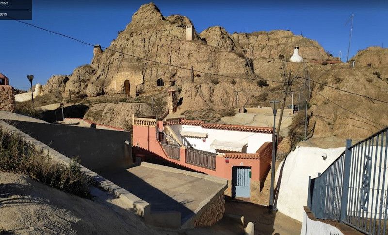
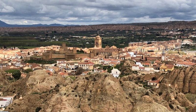
Guadix, Spanien
cave houses
C. Virgen de Fátima, 72, 18500 Guadix, Granada, Spanien
37° 17' 30.5" N 3° 8' 17.3" W
37.2918110 -3.1381441
• Head toward Calle Primera Cañada Cuatro Veredas on Calle Cuatro Veredas. Go for 76 m.
• Turn right onto Calle Primera Cañada Cuatro Veredas. Go for 58 m.
• Turn left onto Calle Primera Cañada Cuatro Veredas. Go for 81 m.
• Turn slightly left onto Calle Eras de Lara. Go for 48 m.
• Turn left toward Calle Cañada de Lara. Go for 38 m.
• Turn left onto Calle Cañada de Lara. Go for 61 m.
• Turn slightly right onto Calle Cañada de Gracia. Go for 240 m.
• Turn right onto Calle Carrera de las Cruces. Go for 54 m.
• Continue on Calle Carrera de las Cruces. Go for 262 m.
• Turn slightly left onto Calle San Miguel. Go for 96 m.
• Turn left onto Calle San Miguel. Go for 11 m.
• Turn right onto Calle San Miguel. Go for 339 m.
• Continue on Plaza Torreón del Ferro. Go for 18 m.
• Take the 1st exit from roundabout onto Calle San Miguel. Go for 121 m.
• Turn left onto Carretera de Granada (A-4100). Go for 514 m.
• Pass 2 roundabouts and continue on Carretera de Granada (A-4100). Go for 661 m.
• Continue on A-4100. Go for 237 m.
• Continue on Carretera de Granada (A-4100). Go for 1.2 km.
• Turn right toward A-92/Baza/Murcia/Granada. Go for 415 m.
• Take the 3rd exit from roundabout toward Granada/A-92. Go for 149 m.
• Turn left and take ramp onto A-92 toward Granada. Go for 10.1 km.
• Take exit 282 toward La Peza/A-4105. Go for 293 m.
• Take the 5th exit from roundabout onto A-308 toward La Peza/A-4105/Lopera. Go for 394 m.
• Take the 1st exit from roundabout toward A-4105/La Peza/Lopera. Go for 2.2 km.
• Turn right onto GR-3201. Go for 1.2 km.
• Arrive at GR-3201. Your destination is on the left.
☍
18,9 km
( 20 min.)
Parking Caravanas
Nice overnight stay at the reservoir
GR-3201, 18517 La Peza, Granada, Spanien
37° 18' 47.9" N 3° 15' 10.8" W
37.3133133 -3.2529902
• Head northeast on GR-3201. Go for 1.2 km.
• Turn sharp left toward A-308. Go for 2.2 km.
• Take the 2nd exit from roundabout onto A-308 toward A-92/Granada/Darro/Jaén. Go for 280 m.
• Take the 4th exit from roundabout onto A-92 toward Granada. Go for 31.8 km.
• Take exit 250 toward Víznar. Go for 309 m.
• Turn right onto Camino de Víznar (GR-3102) toward A-92/Guadix/Almería/Murcia. Go for 4.5 km.
• Take the 2nd exit from roundabout onto Calle Alcalde Mosén Rubí de Bracamonte. Go for 685 m.
• Take the 3rd exit from roundabout onto Camino de Alfacar. Go for 394 m.
• Take the 2nd exit from Plaza Santa Bonifacia Rodríguez roundabout onto Camino de Alfacar. Go for 592 m.
• Continue on Paseo de Cartuja. Go for 22 m.
• Turn right onto Calle Doctor González de Vega. Go for 274 m.
• Take the 3rd exit from roundabout onto Avenida Pulianas. Go for 861 m.
• Continue on Plaza de San Isidro toward Centro Ciudad. Go for 75 m.
• Continue on Calle Ancha de Capuchinos. Go for 354 m.
• Turn right onto Avenida del Hospicio. Go for 99 m.
• Continue on Avenida de la Constitución. Go for 39 m.
• Take the 2nd exit from roundabout onto Calle Gran Vía de Colón. Go for 779 m.
• Arrive at Calle Gran Vía de Colón.
☍
44,4 km
( 35 min.)
Day
Granada
Arrival at Camping Reina Isabelle and short stroll through town
Spanien
37° 10' 38.9" N 3° 35' 54.4" W
37.1774605 -3.5984368
• Head southeast on Calle Gran Vía de Colón. Go for 202 m.
• Continue on Plaza Isabel La Católica. Go for 93 m.
• Continue on Calle Pavaneras. Go for 98 m.
• Continue on Calle Santa Escolástica. Go for 163 m.
• Continue on Plaza de Fortuny. Go for 69 m.
• Turn left onto Plaza del Realejo. Go for 49 m.
• Turn right onto Calle Molinos. Go for 581 m.
• Turn left onto Cuesta Caidero. Go for 354 m.
• Continue on Calle Antequeruela Baja. Go for 189 m.
• Continue on Paseo del Generalife. Go for 478 m.
• Turn left toward Paseo del Generalife. Go for 19 m.
• Continue on Paseo del Generalife. Go for 182 m.
• Continue on Avenida del Generalife. Go for 131 m.
• Continue on Avenida del Generalife. Go for 32 m.
• Continue on Calle Real de la Alhambra. Go for 293 m.
• Arrive at Calle Real de la Alhambra. Your destination is on the left.
☍
2,9 km
( 11 min.)
Day
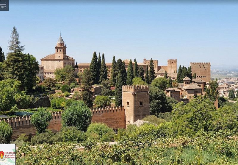
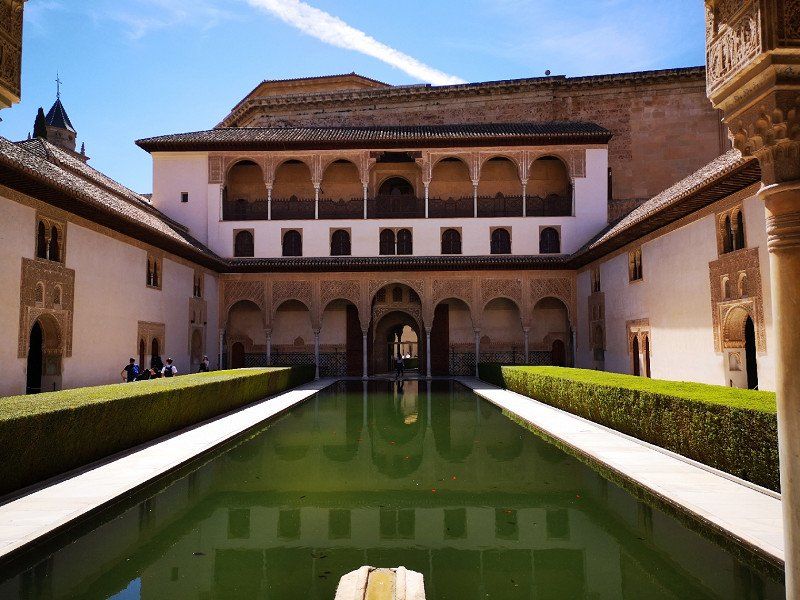
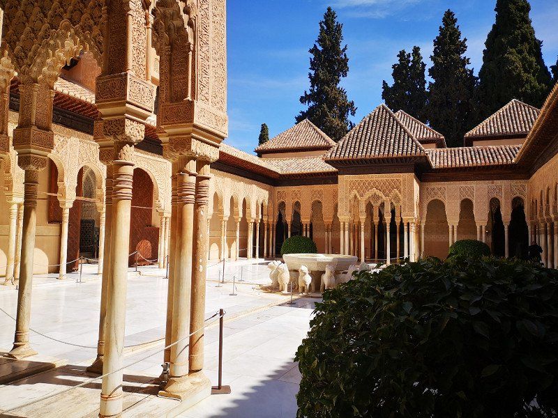
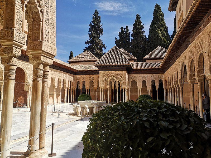
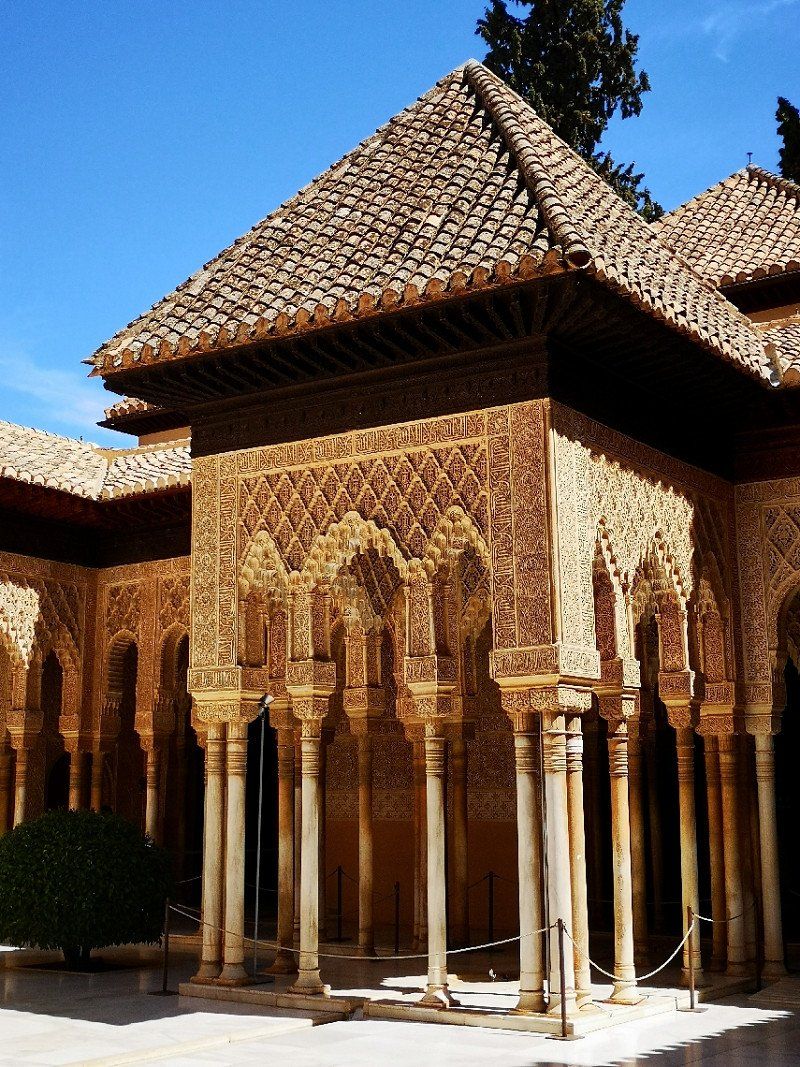
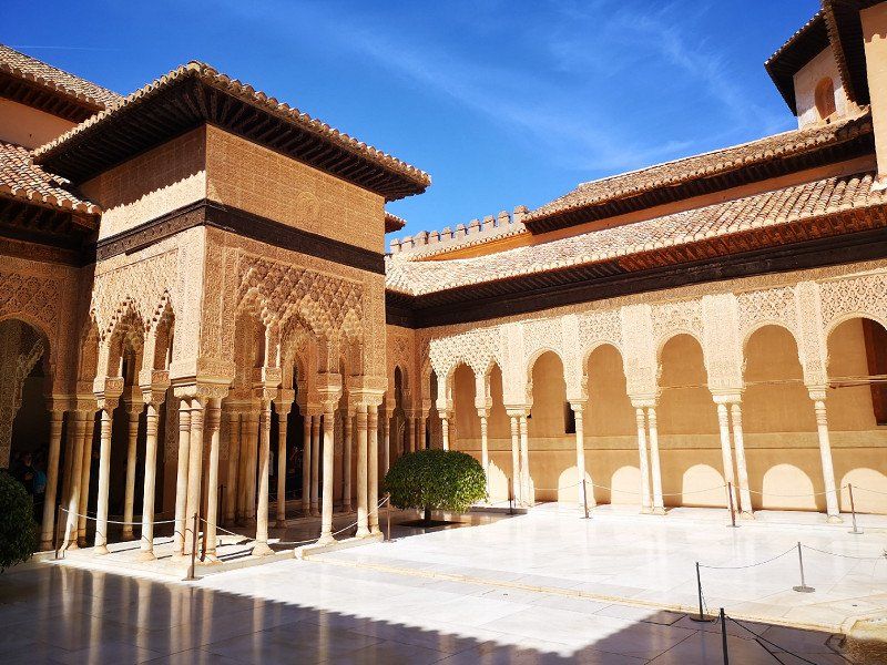
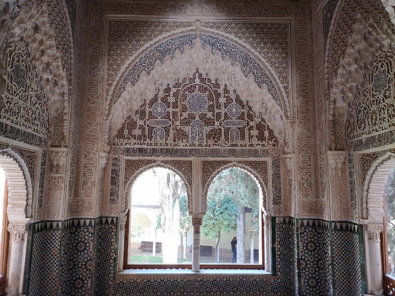
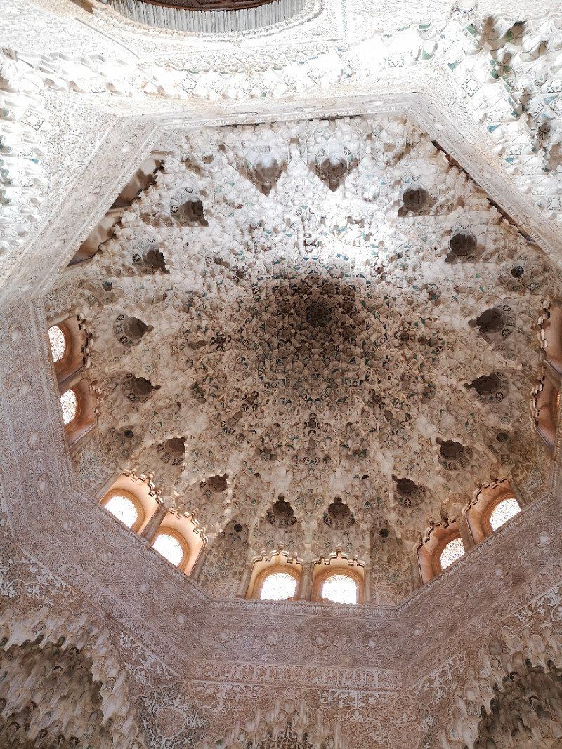
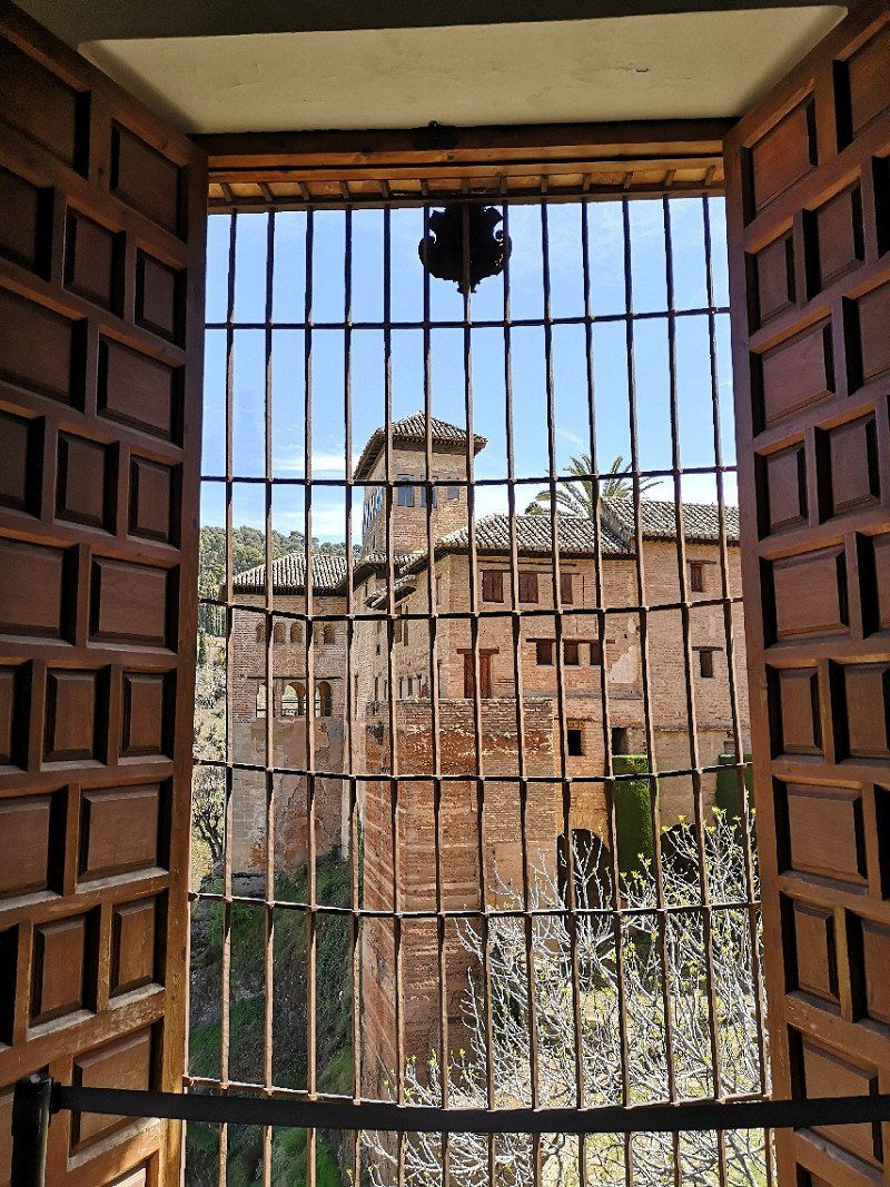
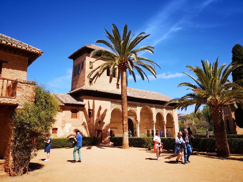
Alhambra, Calle Real de la Alhambra, Granada, Spanien
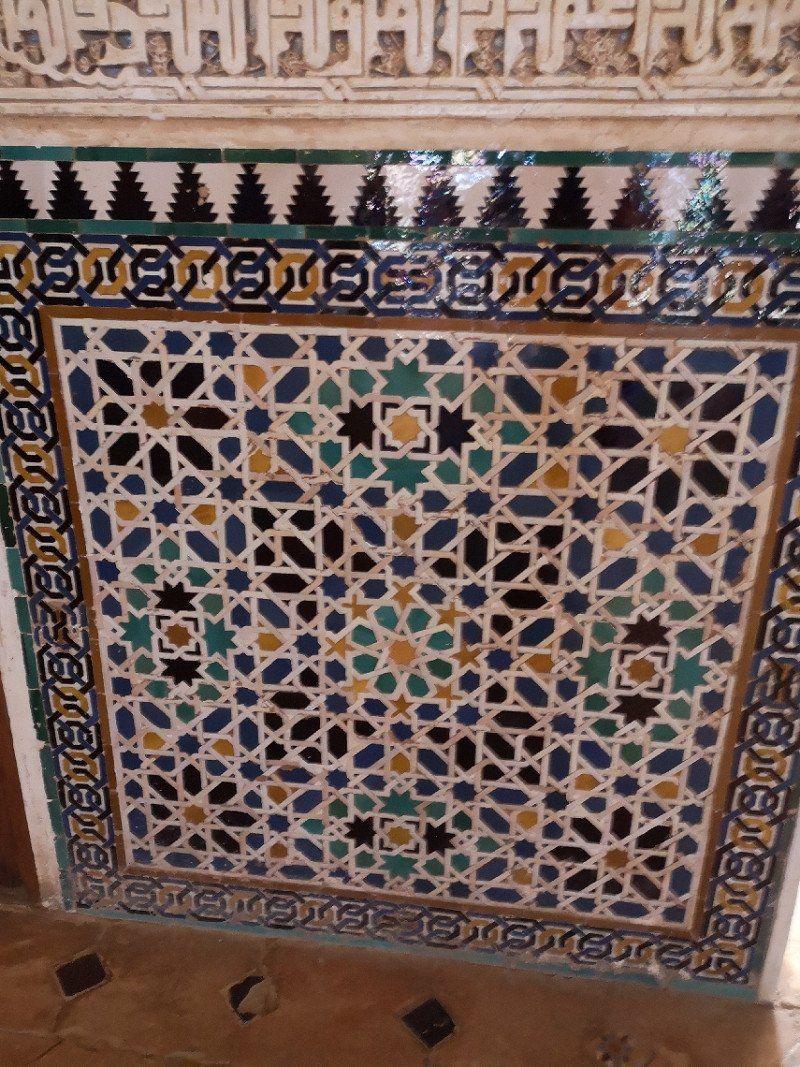
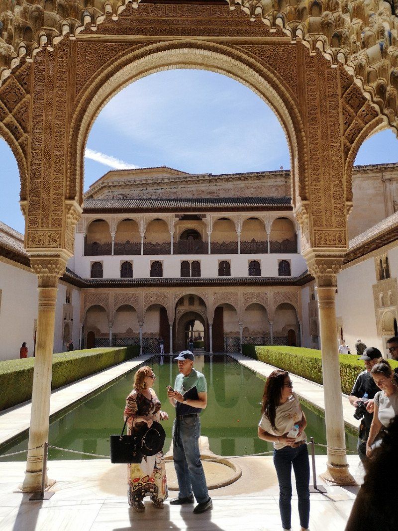
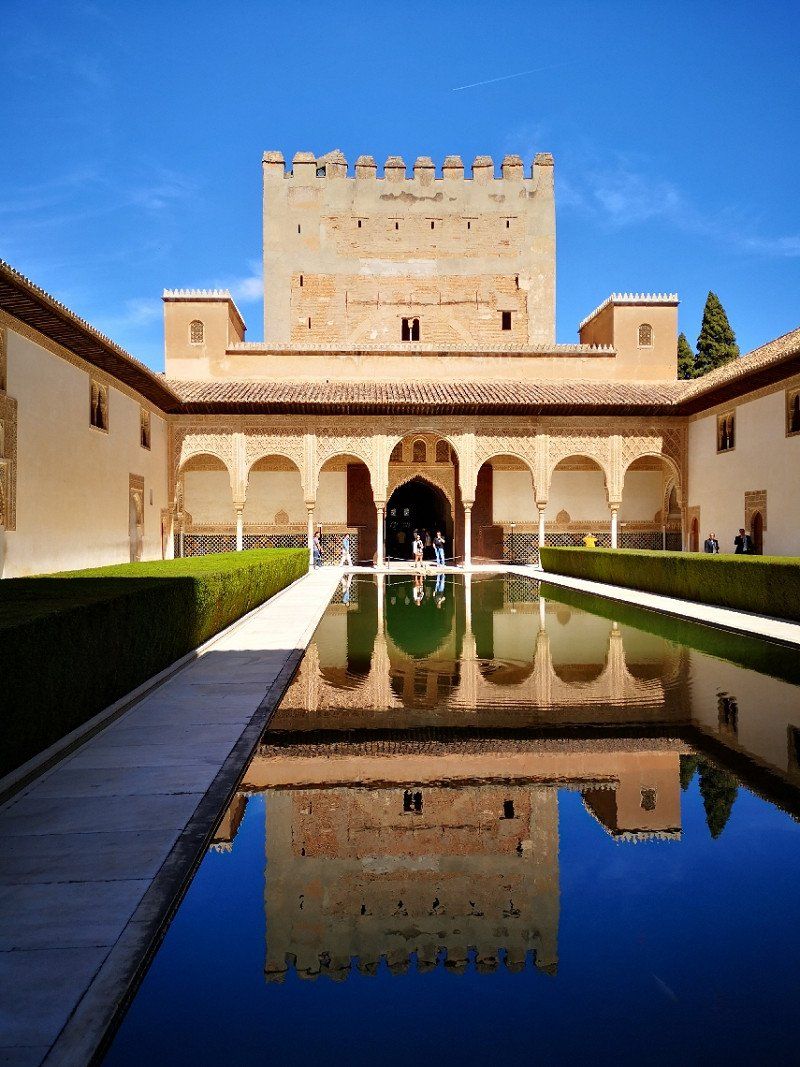
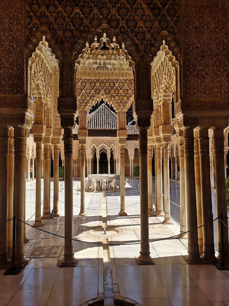
An incredibly impressive building, especially the Nasrid Palace with its filigree and rich ornaments and decorations. This is a must on any Spain trip.
Be sure to book your ticket online in advance, as the Nasrid Palace can only be visited to a limited extent and at certain times.
Often with a Fastline (without queuing) and bus tickets included, we could not see the Fastline and the ticket was not recognized on the bus... Advertising tricks
C. Real de la Alhambra, s/n, 18009 Granada, Spanien
37° 10' 33.9" N 3° 35' 17.3" W
37.1760783 -3.5881413
• Head toward Avenida del Generalife on Calle Real de la Alhambra. Go for 293 m.
• Turn right toward Paseo del Generalife. Go for 373 m.
• Turn right onto Paseo del Generalife. Go for 41 m.
• Continue on Calle Antequeruela Baja. Go for 189 m.
• Continue on Cuesta Caidero. Go for 354 m.
• Turn left onto Calle Vistillas de los Ángeles toward Cuesta de Escoriaza. Go for 179 m.
• Continue on Cuesta Escoriaza. Go for 366 m.
• Turn right onto Paseo de la Bomba. Go for 122 m.
• Continue on Paseo del Salón. Go for 338 m.
• Continue on Plaza del Humilladero. Go for 79 m.
• Turn right onto Calle Acera del Darro. Go for 544 m.
• Turn right onto Calle Ángel Ganivet. Go for 228 m.
• Turn slightly left onto Plaza de Mariana Pineda. Go for 20 m.
• Turn left onto Calle San Matías. Go for 342 m.
• Turn left onto Plaza Isabel La Católica. Go for 93 m.
• Continue on Calle Gran Vía de Colón. Go for 202 m.
• Arrive at Calle Gran Vía de Colón.
☍
3,8 km
( 15 min.)
Day
Granada
Spanien
37° 10' 38.9" N 3° 35' 54.4" W
37.1774605 -3.5984368
• Head northwest on Calle Gran Vía de Colón. Go for 706 m.
• Take the 2nd exit from roundabout onto Avenida de la Constitución. Go for 873 m.
• Continue on Avenida de Andalucía. Go for 266 m.
• Keep left onto Avenida de Andalucía toward Chana/Aeropuerto. Go for 706 m.
• Take the 2nd exit from roundabout onto Avenida de Andalucía (N-432). Go for 2.2 km.
• Keep left onto Carretera de Córdoba (N-432) toward A-92G/Málaga/Sevilla/Aeropuerto. Go for 398 m.
• Continue on A-92G. Go for 9.0 km.
• Take left ramp onto A-92 toward Málaga/Sevilla. Go for 83.2 km.
• Take exit 146 toward Campillos/Ronda/Antequera/El Torcal onto A-384. Go for 24.0 km.
• Turn left toward Ronda/Ardales. Go for 61 m.
• Keep right onto A-357 toward Ronda/Ardales/Málaga. Go for 8.6 km.
• Turn slightly left onto A-7286 toward Parque Guadalteba. Go for 2.2 km.
• Continue straight ahead. Go for 4.6 km.
• Turn right toward Área Pantano Chorro. Go for 816 m.
• Continue on Área Pantano Chorro. Go for 693 m.
• Turn left onto Pantano del Chorro. Go for 96 m.
• Turn right toward El Mirador. Go for 819 m.
• Turn slightly left onto El Mirador. Go for 1.1 km.
• Arrive at your destination.
☍
140,4 km
(1 hrs. 39 min.)
Day
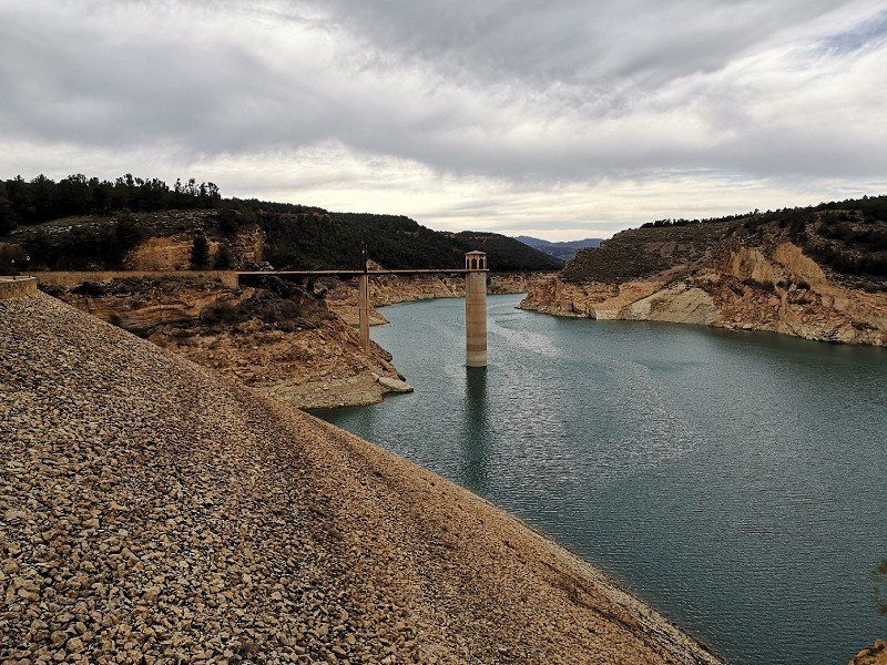
Camping Parque Ardales
A place where you can switch off, unfortunately the reservoir currently has very little water.
Vía sin nombre, 29550 Ardales, Málaga, Spanien
36° 55' 15.9" N 4° 48' 9.8" W
36.9210747 -4.8027290
• Head southwest. Go for 1.0 km.
• Take the 3rd exit from roundabout onto MA-5403. Go for 5.9 km.
• Continue on Carretera El Chorro (MA-5403). Go for 207 m.
• Turn left onto Carretera El Chorro (MA-5403). Go for 51 m.
• Continue on MA-5403. Go for 504 m.
• Turn slightly left onto Calle Estación Chorro. Go for 297 m.
• Turn slightly right. Go for 1.1 km.
• Arrive at your destination.
☍
9,0 km
( 22 min.)
Day
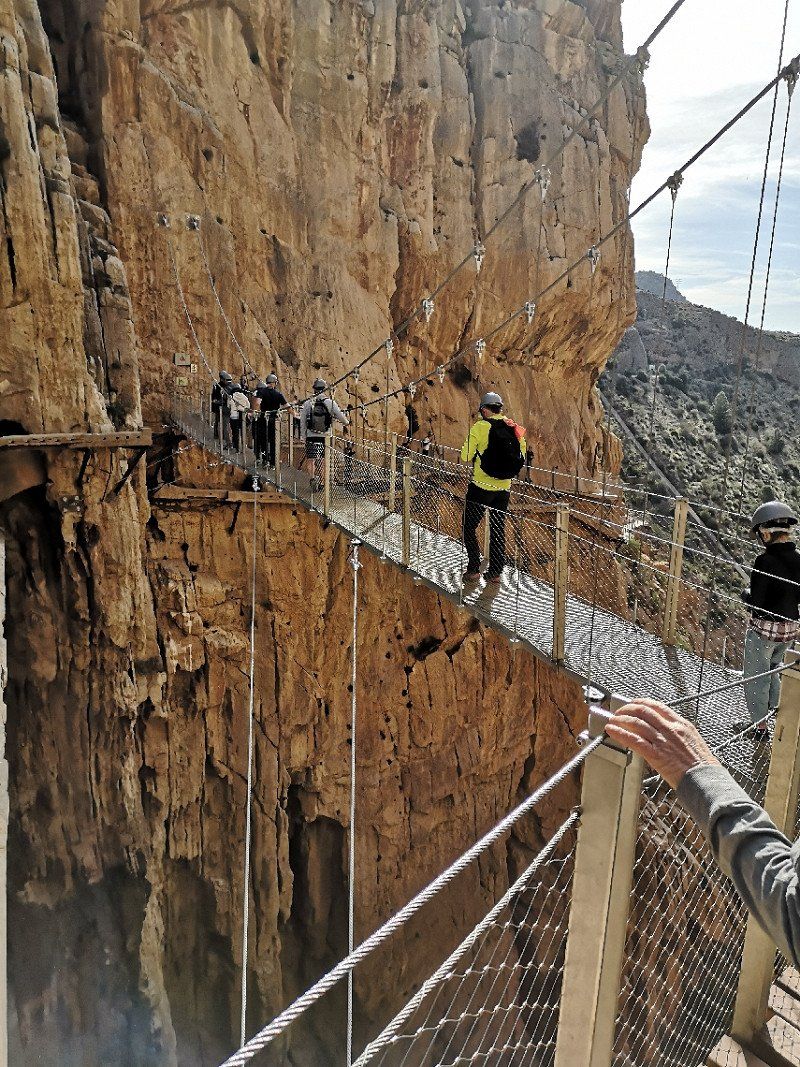
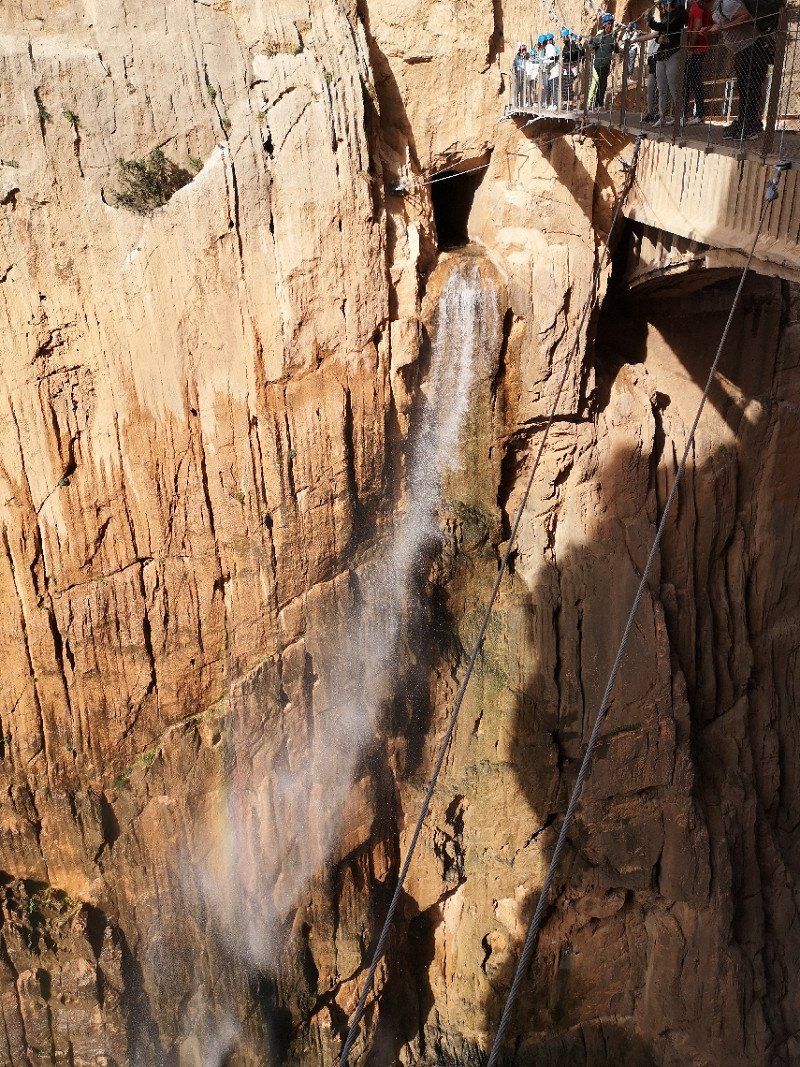
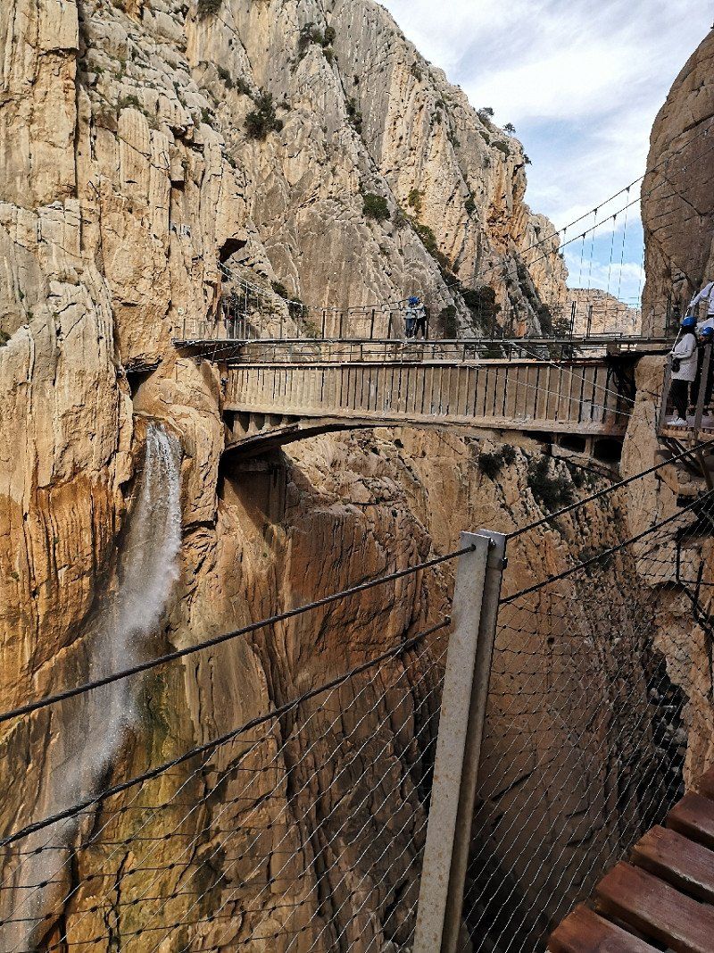
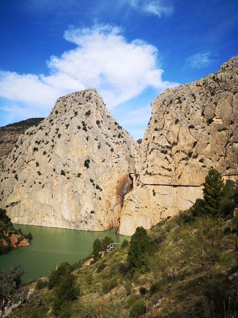
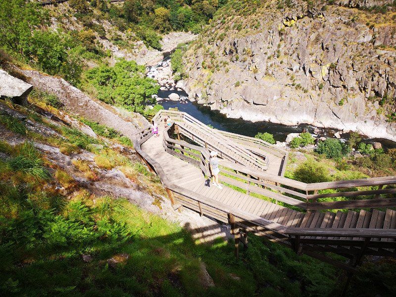
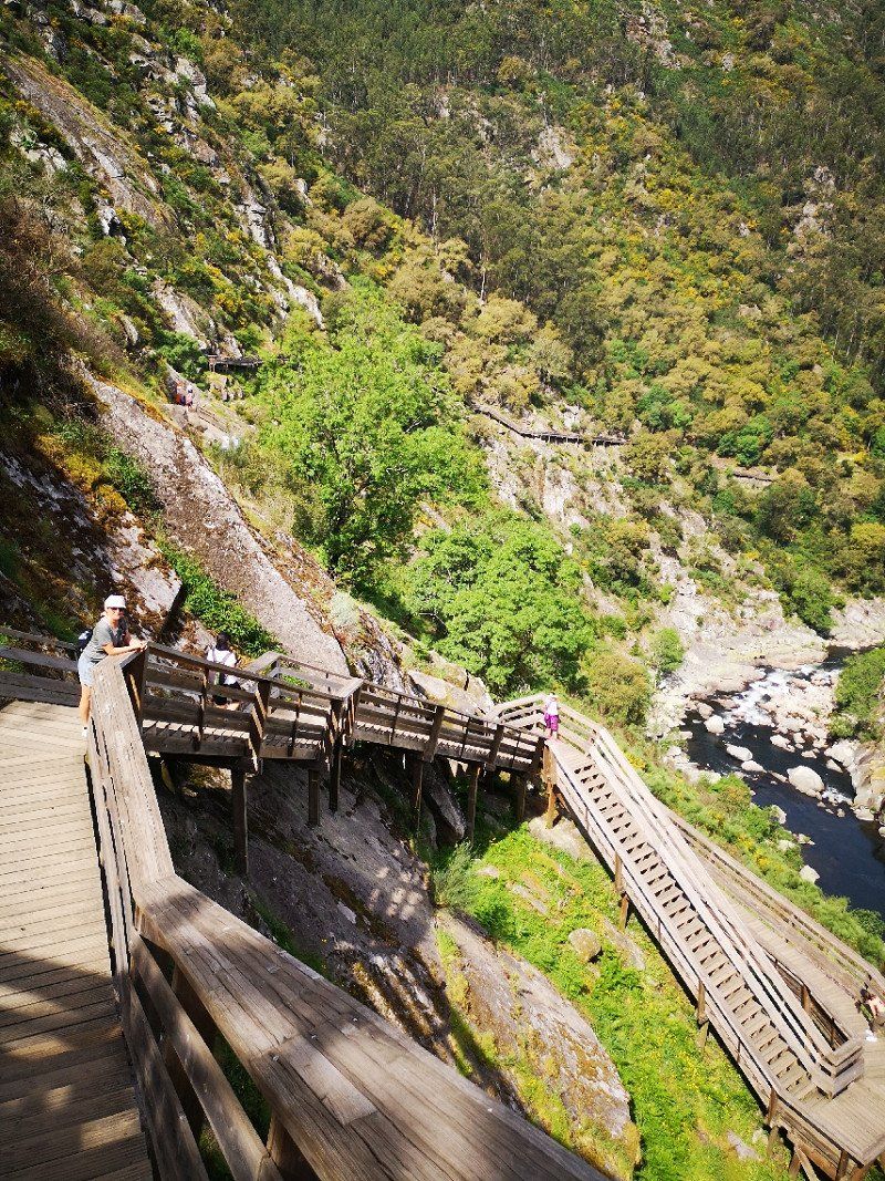
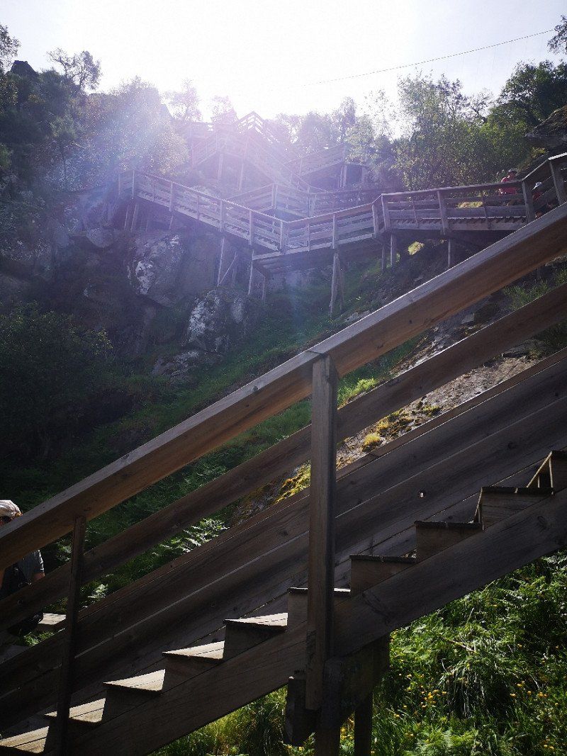
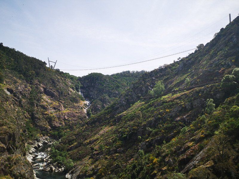
Caminito del Rey., El Caminito del Rey, Málaga, Spanien
Very beautiful gorge with an even more breathtaking path. Must see
El Caminito del Rey, 29200 Málaga, Spanien
36° 54' 57.3" N 4° 46' 17.2" W
36.9159140 -4.7714424
• Head southeast. Go for 1.1 km.
• Turn slightly left onto Calle Estación Chorro. Go for 297 m.
• Turn slightly right onto MA-5403. Go for 504 m.
• Continue on Carretera El Chorro (MA-5403). Go for 51 m.
• Turn right onto Carretera El Chorro (MA-5403). Go for 207 m.
• Continue on MA-5403. Go for 5.8 km.
• Take the 1st exit from roundabout. Go for 1.0 km.
• Arrive at your destination.
☍
9,0 km
( 22 min.)
Day
Camping Parque Ardales
1 day of relaxation in the middle of nature
Vía sin nombre, 29550 Ardales, Málaga, Spanien
36° 55' 15.9" N 4° 48' 9.8" W
36.9210747 -4.8027290
• Head southwest. Go for 1.0 km.
• Take the 2nd exit from roundabout onto MA-5403. Go for 5.5 km.
• Turn right onto MA-5403. Go for 101 m.
• Continue on A-357. Go for 6.7 km.
• Take ramp toward Teba/A-367/Ronda/A-7278. Go for 265 m.
• Take the 2nd exit from roundabout toward Teba/A-7278/Ronda/A-367. Go for 111 m.
• Take the 1st exit from roundabout onto A-367 toward Teba/A-7278/Ronda. Go for 22.9 km.
• Turn right toward Alcalá del Valle. Go for 24 m.
• Turn right onto A-7276. Go for 302 m.
• Continue on Carretera de Setenil a Cuevas del Becerro (A-7276). Go for 695 m.
• Continue on A-7276. Go for 10.1 km.
• Take the 3rd exit from roundabout onto CA-9121. Go for 1.7 km.
• Continue on Casas Nuevas (CA-9121). Go for 22 m.
• Continue on CA-9121. Go for 308 m.
• Take the 1st exit from roundabout onto CA-9121. Go for 258 m.
• Continue on Calle Federico García Lorca. Go for 357 m.
• Arrive at Calle Federico García Lorca. Your destination is on the left.
☍
50,5 km
( 47 min.)
Day
Setenil de las Bodegas
Unspectacular village... Only went shopping
Spanien
36° 51' 44.7" N 5° 10' 35.2" W
36.8624263 -5.1764469
• Head west on Calle Federico García Lorca. Go for 174 m.
• Continue on Calle Carril Alto. Go for 425 m.
• Continue on Calle Alcaide Manrique. Go for 173 m.
• Turn left onto Calle San Sebastián. Go for 650 m.
• Continue on CA-9113. Go for 2.3 km.
• Turn left onto MA-8406. Go for 4.7 km.
• Continue on MA-7402 toward Ronda. Go for 694 m.
• Turn right onto MA-8405 toward Montecorto/Los Villalones. Go for 4.4 km.
• Turn left onto MA-8407 toward Montecorto. Go for 4.6 km.
• Continue on Camino de Montecorto a Villalones (MA-8407). Go for 201 m.
• Continue on Calle Pablo Ruíz Picasso (MA-8407). Go for 19 m.
• Turn left onto Avenida de la Constitución (MA-8407). Go for 642 m.
• Turn right and take ramp onto A-374. Go for 1.6 km.
• Turn left onto A-7378 toward Zahara. Go for 1.3 km.
• Continue on A-2300. Go for 939 m.
• Continue on A-6300. Go for 158 m.
• Continue on A-2300. Go for 7.2 km.
• Turn left onto CA-9112. Go for 1.9 km.
• Take the 1st exit from roundabout onto CA-9104. Go for 656 m.
• Turn left onto Avenida de Andalucía toward Zahara. Go for 401 m.
• Turn slightly left onto Avenida de Andalucía. Go for 17 m.
• Continue on Calle Fernando Hué. Go for 83 m.
• Turn right onto Avenida de Andalucía. Go for 76 m.
• Continue on Calle Boquete San Juan. Go for 119 m.
• Turn left onto Calle San Juan. Go for 28 m.
• Turn left onto Calle Doctor Gómez Ulla. Go for 31 m.
• Turn left onto Calle Manchega. Go for 123 m.
• Arrive at Calle Manchega. Your destination is on the left.
☍
33,8 km
( 38 min.)
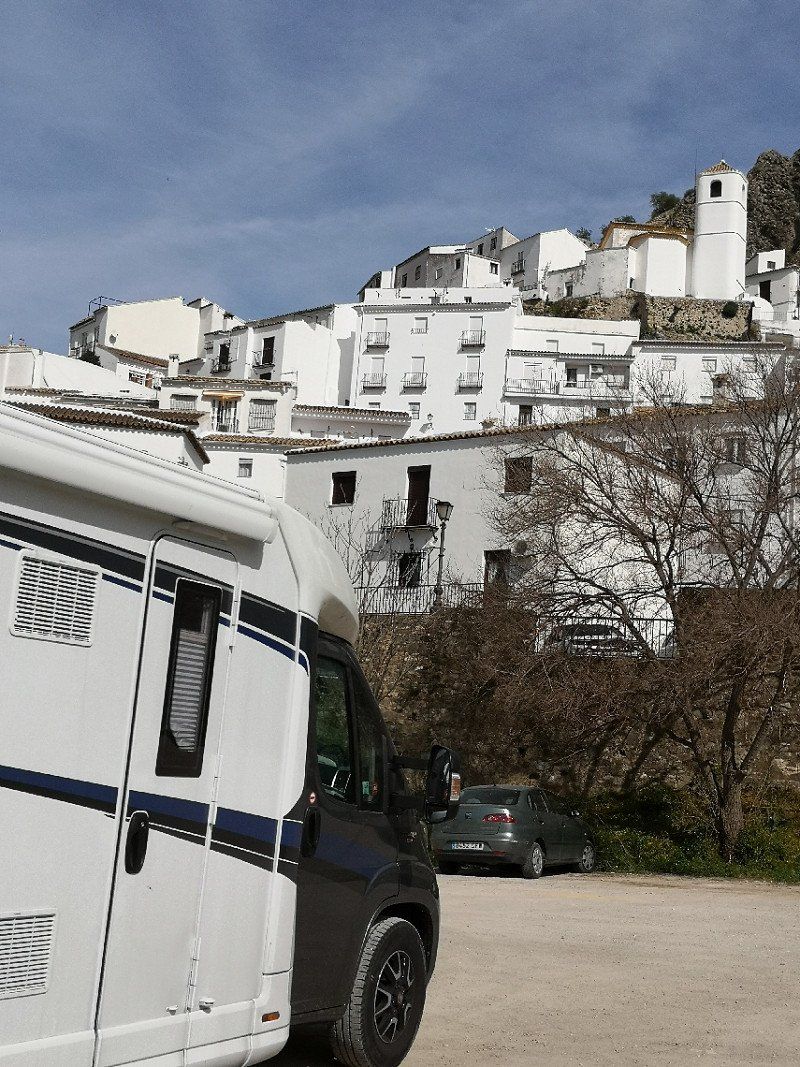
Zahara de la Sierra
Stayed in a parking lot, 5 minutes to the center. Nice village with a cozy village square for eating, etc.
Spanien
36° 50' 22.2" N 5° 23' 31.2" W
36.8394942 -5.3919919
• Head toward Avenida de Andalucía on Calle Manchega. Go for 28 m.
• Turn slightly right onto Calle Fernando Hué. Go for 83 m.
• Continue on Avenida de Andalucía. Go for 139 m.
• Keep right onto Avenida de Andalucía. Go for 279 m.
• Turn left onto CA-9104. Go for 871 m.
• Continue on Calle Los Vientos (CA-9104). Go for 38 m.
• Continue on CA-9104. Go for 277 m.
• Turn slightly left onto A-2300 toward Algodonales/Jerez de la Frontera. Go for 6.2 km.
• Turn right onto CA-9105. Go for 195 m.
• Turn left toward A-384. Go for 123 m.
• Turn right onto A-384. Go for 2.9 km.
• Take ramp onto A-384 toward Olvera/Antequera. Go for 14.2 km.
• Turn left onto CA-9102 toward Olvera. Go for 2.1 km.
• Continue on Calle Noria (CA-9102). Go for 295 m.
• Turn left onto Calle Bellavista (CA-9102). Go for 388 m.
• Turn right onto Calle San Juan Bosco. Go for 227 m.
• Arrive at Calle San Juan Bosco.
☍
28,2 km
( 26 min.)
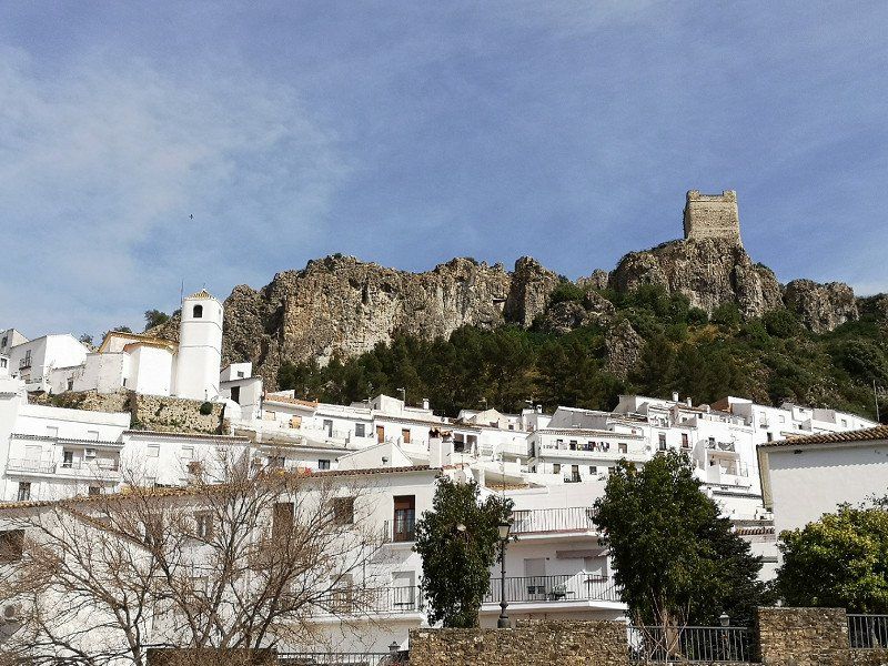
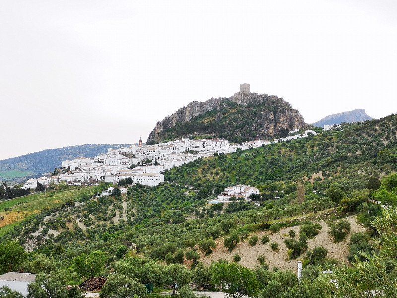
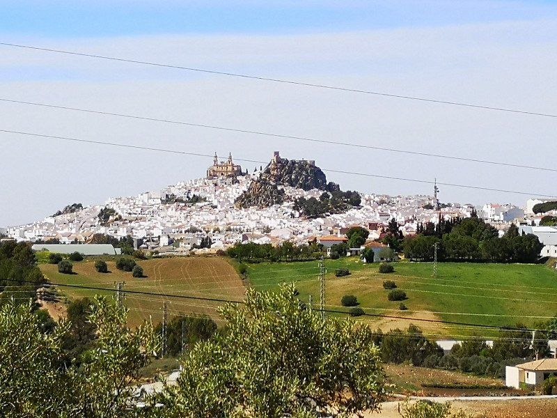
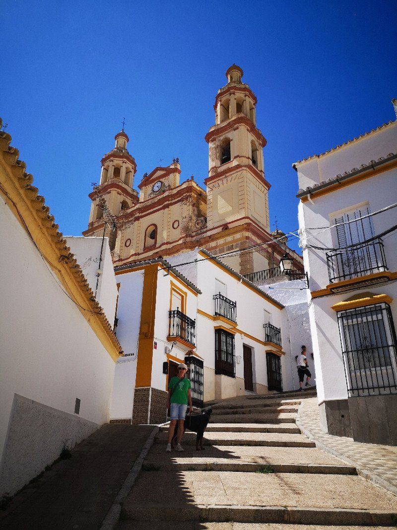
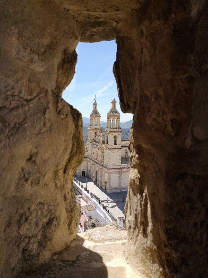
Olvera
On the route of the white villages. Very nice cathedral and castle with great views. Admission to the castle €2, it's worth it
Spanien
36° 56' 6.9" N 5° 15' 35.8" W
36.9352388 -5.2599555
• Head east on Calle San Juan Bosco. Go for 83 m.
• Take the 3rd exit from roundabout onto Calle Sepúlveda. Go for 120 m.
• Turn left onto Calle Pruna. Go for 5 m.
• Continue on Calle Bellavista (CA-9102). Go for 786 m.
• Turn right onto Calle Noria (CA-9102). Go for 295 m.
• Continue on CA-9102. Go for 2.1 km.
• Turn slightly right onto A-384 toward Algodonales/Jerez de la Fra. Go for 13.7 km.
• Take left ramp onto A-374/A-384 toward El Gastor/Ronda. Go for 12.0 km.
• Turn right onto A-7378. Go for 1.3 km.
• Continue on A-2300. Go for 939 m.
• Turn left onto CA-9123 toward Grazalema. Go for 8.7 km.
• Turn right onto A-372. Go for 1.1 km.
• Turn right onto Calle Empedrada. Go for 23 m.
• Turn left onto Calle Empedrada. Go for 24 m.
• Continue on Calle José María Jiménez. Go for 58 m.
• Turn right onto Plaza de España. Go for 7 m.
• Turn right onto Calle de las Piedras. Go for 215 m.
• Arrive at Calle de las Piedras. Your destination is on the right.
☍
41,5 km
( 39 min.)
Day
Grazalema
Spanien
36° 45' 31.2" N 5° 22' 6.4" W
36.7586748 -5.3684385
• Head west on Calle de las Piedras. Go for 31 m.
• Turn right onto Calle Portal. Go for 201 m.
• Turn sharp left onto A-372. Go for 4.1 km.
• Continue on A-2302. Go for 8.4 km.
• Take the 2nd exit from roundabout onto Calle Ermita (A-2302). Go for 11.9 km.
• Turn left onto Carretera Ubrique-El Bosque (A-373) toward Ubrique/Cortes de la Frontera/A-375/Alcalá de los Gazules/Jimena de la Frontera. Go for 1.0 km.
• Turn right onto Avenida de Cádiz (A-373). Go for 284 m.
• Take the 1st exit from Glorieta de RTVE roundabout onto Avenida de los Callejones (A-373) toward Centro Ciudad. Go for 267 m.
• Arrive at Avenida de los Callejones (A-373).
☍
26,2 km
( 31 min.)
Day
Ubrique
Spanien
36° 40' 37.5" N 5° 26' 43.4" W
36.6770842 -5.4453900
• Head toward Calle San José on Avenida de los Callejones (A-373). Go for 253 m.
• Take the 2nd exit from Glorieta de RTVE roundabout onto Avenida Carrero Blanco. Go for 238 m.
• Turn left onto Avenida Juan de la Rosa toward El Bosque/Grazalema/Ronda. Go for 108 m.
• Turn right onto Carretera Ubrique-El Bosque (A-373). Go for 1.0 km.
• Turn right onto A-2302. Go for 11.9 km.
• Take the 2nd exit from roundabout onto Calle Ermita (A-2302). Go for 8.4 km.
• Turn right onto A-372. Go for 10.3 km.
• Turn right onto A-372 toward Ronda. Go for 1.4 km.
• Keep left toward A-372. Go for 39 m.
• Turn right onto A-374. Go for 13.0 km.
• Turn right onto Calle Prado del Rey. Go for 168 m.
• Continue on Avenida de la Legión Española. Go for 138 m.
• Take the 2nd exit from roundabout onto Avenida de la Legión Española toward Algodonales/A-374/Sevilla/Pol. Industrial Ronda Norte. Go for 1.5 km.
• Turn right onto Calle Doctor Fernando Morell Castelló. Go for 48 m.
• Turn left onto Calle el Molino. Go for 46 m.
• Turn left onto Avenida Victoria. Go for 173 m.
• Turn slightly right onto Calle Comandante Salvador Carrasco. Go for 191 m.
• Take the 3rd exit from Plaza Concepción García Redondo roundabout onto Avenida de Andalucía. Go for 333 m.
• Turn right onto Calle Doctor Carrillo Guerrero. Go for 191 m.
• Enter the roundabout. Go for 43 m.
• Arrive at Plaza del Ahorro. Your destination is on the left.
☍
49,5 km
( 54 min.)
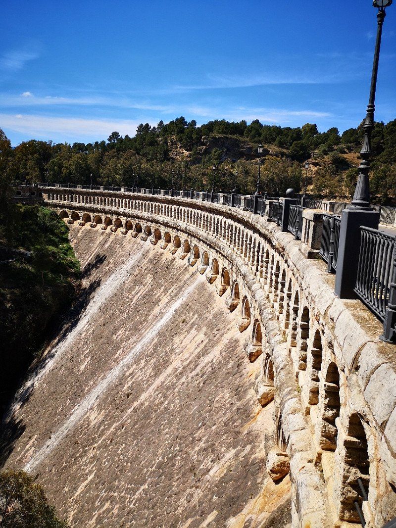
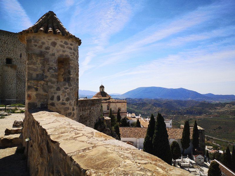
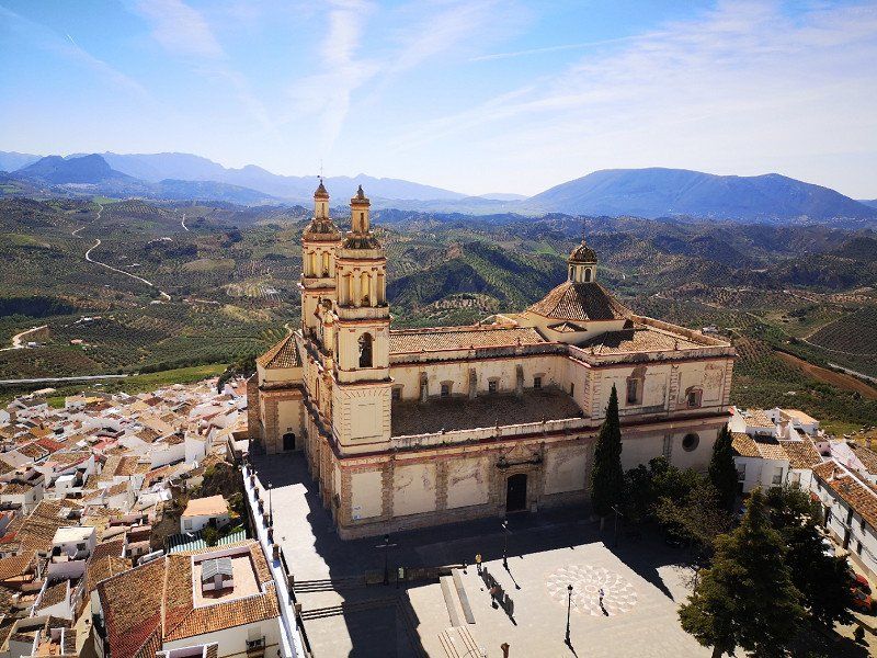
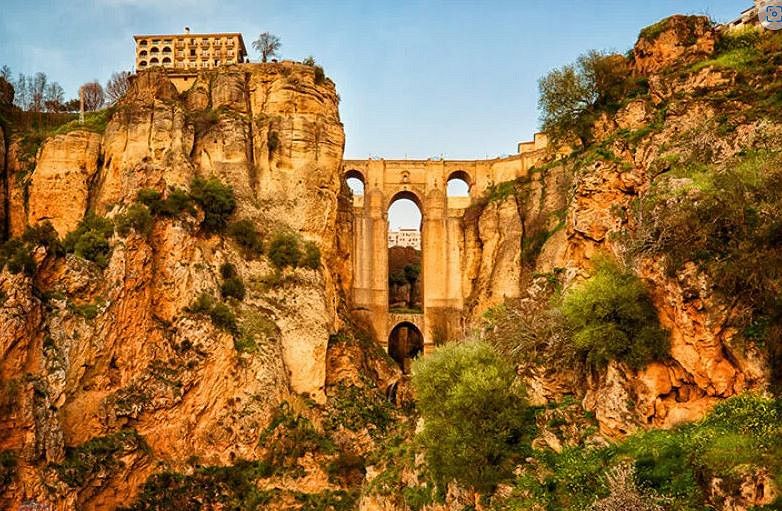
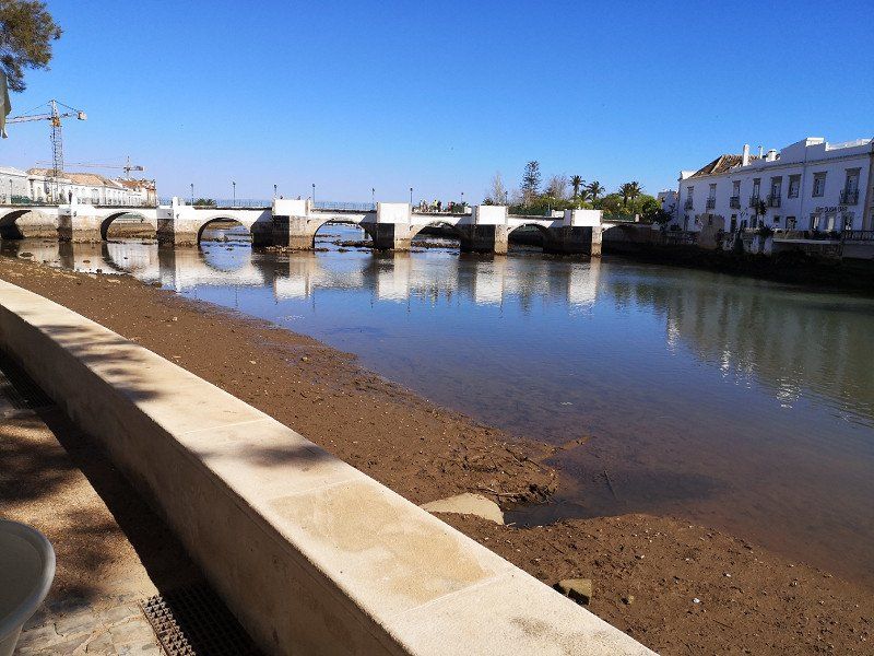
Ronda, Spanien
Ronda: One of the most beautiful cities in Andalusia
From Gibraltar we drive to sun-kissed Andalusia in the deep south of Spain. Don't miss the beautiful city of Ronda! The old and new town are separated by a deep gorge and only connected by an imposing bridge - unique in Spain. Even from afar, the white houses of the small town catch your eye.
Ronda is also a great starting point for trekking and hiking tours as it is situated on a sloping stone plateau. From here you can get to know the beautiful nature of Andalusia wonderfully. Popular regions for hiking are the Sierra de Grazalema in the west and the Sierra de las Nieves in the east. Contrary to the name, you can also hike in the "Snow Mountains" in winter, as snow only falls here in exceptional cases.
The Rio Guadalevin flows in the valley, over which the bridge, built between 1751 and 1793, spans. Hundreds of years ago, the river, which is quite narrow today, formed this mighty gorge. It is over 120 meters deep and 90 meters wide. A visit to Ronda is worthwhile just to see the bridge. Many myths and legends are entwined around the building. One says that the builder fell to his death from the bridge, knowing full well that he would never create anything so gigantic again.
29400 Ronda, Provinz Málaga, Spanien
36° 44' 46.4" N 5° 9' 40.4" W
36.7462090 -5.1612251
• Follow the roundabout.
• Take the 1st exit from roundabout onto Calle Jaén. Go for 61 m.
• Turn right onto Avenida Martínez Astein. Go for 77 m.
• Turn left onto Avenida de Málaga. Go for 335 m.
• Pass 4 roundabouts and continue on Avenida de Málaga. Go for 1.0 km.
• Take the 1st exit from roundabout onto Carretera de Circunvalación (A-397) toward San Pedro Alcántara/Algeciras. Go for 45.5 km.
• Take the 2nd exit from roundabout onto Carretera Ronda-San Pedro (A-397) toward A-7/N-340/Málaga/Algeciras. Go for 417 m.
• Take ramp onto AP-7 (Autopista del Mediterráneo) toward Algeciras. Go for 16.7 km.
• Continue on A-7 (Autovía del Mediterráneo). Go for 2.4 km.
• Continue on AP-7 (Autopista del Mediterráneo). Go for 11.6 km.
• Keep right onto AP-7. Go for 10.2 km.
• Continue on A-7 (Autovía del Mediterráneo). Go for 13.4 km.
• Take exit 1106 toward CA-34/La Línea/Gibraltar. Go for 239 m.
• Turn right onto N-340a toward San Roque (Este). Go for 1.1 km.
• Turn left toward CA-34/La Línea/Gibraltar. Go for 214 m.
• Keep left onto CA-34 toward La Línea/Gibraltar. Go for 1.7 km.
• Pass 5 roundabouts and continue on Avenida de España (CA-34). Go for 4.4 km.
• Take the 1st exit from roundabout onto Avenida Príncipe de Asturias (N-351). Go for 552 m.
• Take the 1st exit from Rotonda Real Balompédica Linense roundabout onto Avenida Príncipe de Asturias (N-351). Go for 326 m.
• Turn right onto Avenida Alcaidesa Marina toward Gibraltar. Go for 49 m.
• Take the 2nd exit from roundabout onto Carretera de la Frontera. Go for 414 m.
• Continue on Cerretera de la Frontera. Go for 49 m.
• Turn right. Go for 140 m.
• Continue toward Winston Churchill Avenue. Go for 29 m.
• Continue on Winston Churchill Avenue. Go for 63 m.
• Turn left. Go for 59 m.
• Turn slightly right toward Kingsway. Go for 205 m.
• Take the 1st exit from roundabout onto Kingsway. Go for 378 m.
• Continue on Kingsway Tunnel. Go for 529 m.
• Continue on Kingsway. Go for 367 m.
• Take the 1st exit from roundabout onto Devil's Tower Road. Go for 438 m.
• Take the 1st exit from roundabout onto Devil's Tower Road. Go for 358 m.
• Take the 3rd exit from roundabout onto Winston Churchill Avenue toward City Centre/Port. Go for 323 m.
• Take the 1st exit from roundabout onto Smith Dorrien Avenue. Go for 319 m.
• Take the 1st exit from roundabout onto Line Wall Road. Go for 484 m.
• Turn left onto John Mackintosh Square. Go for 104 m.
• Turn slightly left onto City Mill Lane. Go for 6 m.
• Arrive at City Mill Lane. Your destination is on the left.
☍
114,4 km
(1 hrs. 34 min.)
Day
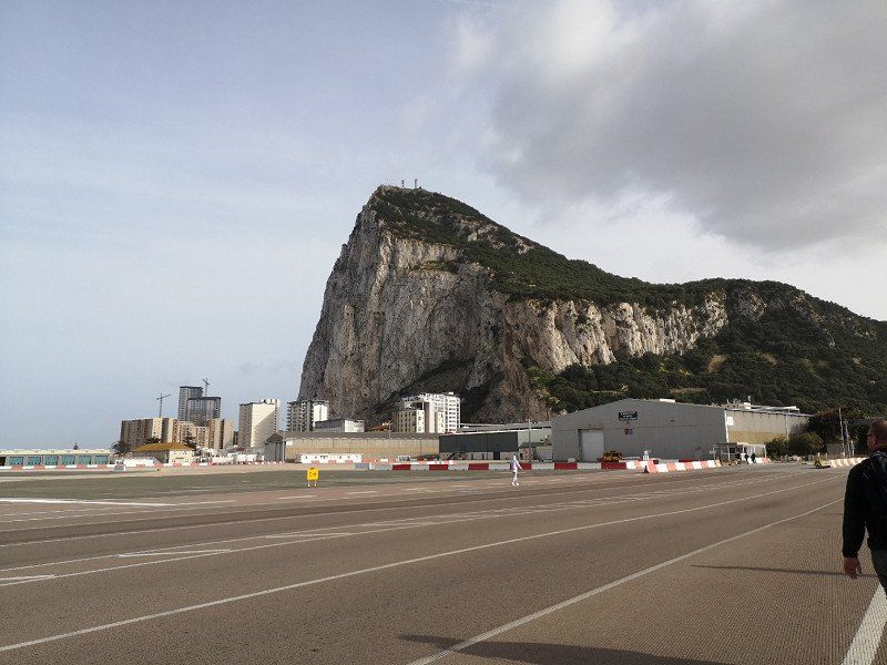
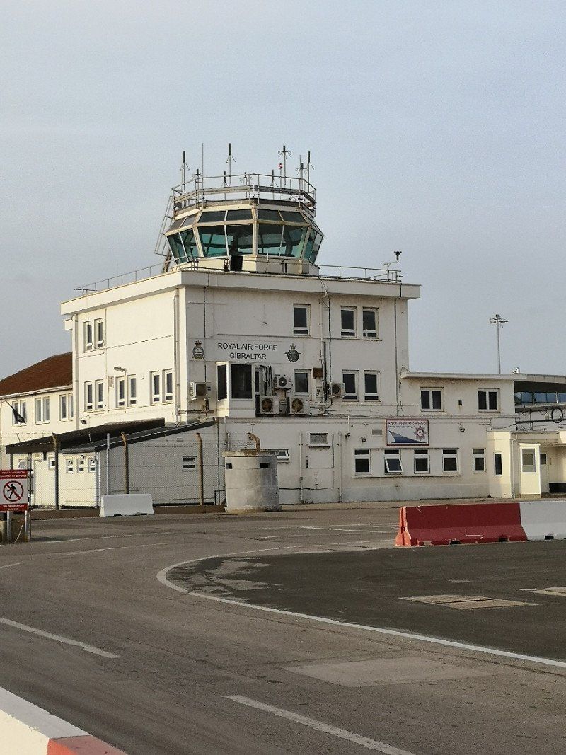
Gibraltar
Visiting the Monkeys of Gibraltar
Did you know that Gibraltar is part of Britain? The 6.5 square kilometer enclave has been a British Overseas Territory since 1704. With one special feature: it is the only one that is also part of the European Union. The first thing that comes to mind when you think of Gibraltar is probably the world famous monkeys in the wild. Legend has it that British rule ended as soon as the last monkey left Gibraltar.
The huge limestone cliff "The Rock" with a height of 426 meters is the highlight of Gibraltar and rises out of the sea like the bow of a ship. The nature reserve "Upper Rock" is probably the number one attraction. In addition to the flora and fauna on the rock, the interior of the rock with its monumental stalactite caves is also well worth seeing. In 2016, the cave complex was even declared a UNESCO World Heritage Site. Also exciting: the last Neanderthals in Europe once lived here.
Tip: The best way to explore "The Rock" is by cable car. Drive all the way up first, then stop at the sights on the way down. And: Don't feed the monkeys, they can get pretty cheeky and steal your bag!
36° 8' 26.7" N 5° 21' 12.9" W
36.1407510 -5.3535850
• Head toward Cornwall's Lane on City Mill Lane. Go for 25 m.
• Turn slightly right onto City Mill Lane. Go for 121 m.
• Turn right onto Governor's Street. Go for 163 m.
• Continue on Town Range. Go for 55 m.
• Turn right onto George's Lane. Go for 113 m.
• Turn left onto Cathedral Square. Go for 72 m.
• Turn right onto Cathedral Square. Go for 34 m.
• Turn slightly left toward Line Wall Road. Go for 34 m.
• Continue on Line Wall Road. Go for 714 m.
• Take the 1st exit from roundabout onto Smith Dorrien Avenue. Go for 323 m.
• Take the 3rd exit from roundabout onto Winston Churchill Avenue. Go for 301 m.
• Take the 1st exit from roundabout onto Devil's Tower Road. Go for 343 m.
• Take the 1st exit from roundabout onto Devil's Tower Road. Go for 434 m.
• Take the 3rd exit from roundabout onto Kingsway. Go for 466 m.
• Continue on Kingsway Tunnel. Go for 550 m.
• Continue on Kingsway. Go for 336 m.
• Take the 2nd exit from roundabout. Go for 256 m.
• Take the 1st exit from roundabout. Go for 236 m.
• Turn right. Go for 140 m.
• Continue toward Avenida Príncipe de Asturias. Go for 151 m.
• Turn right onto Avenida Príncipe de Asturias. Go for 115 m.
• Make a U-Turn onto Avenida Príncipe de Asturias. Go for 511 m.
• Continue on Avenida Príncipe de Asturias (N-351). Go for 269 m.
• Take the 2nd exit from Rotonda Real Balompédica Linense roundabout onto Avenida Príncipe de Asturias (N-351) toward San Roque/Campamento. Go for 533 m.
• Take the 4th exit from roundabout onto Avenida de España (CA-34). Go for 444 m.
• Take the 3rd exit from roundabout onto Avenida de España (CA-34) toward San Roque. Go for 425 m.
• Take the 3rd exit from roundabout onto Avenida de España (CA-34). Go for 422 m.
• Take the 3rd exit from roundabout onto Avenida de España (CA-34) toward San Roque. Go for 1.9 km.
• Pass 2 roundabouts and continue on CA-34. Go for 2.9 km.
• Keep left toward CA-34/San Roque/Algeciras/E-15/A-7/Cádiz/Sevilla. Go for 226 m.
• Take ramp onto A-7 (Autovía del Mediterráneo) toward Algeciras/Cádiz. Go for 9.8 km.
• Keep right onto N-340 toward E-15/A-7/Algeciras Centro Ciudad/Tarifa/Cádiz. Go for 1.3 km.
• Continue on A-7 (Autovía del Mediterráneo). Go for 4.3 km.
• Take exit 103. Go for 276 m.
• Take the 1st exit from roundabout onto N-340 toward Cadiz/Sevilla. Go for 338 m.
• Pass 2 roundabouts and continue on N-340. Go for 17.2 km.
• Keep right onto N-340 toward Vejer de la Frontera/Cádiz. Go for 4.1 km.
• Arrive at N-340. Your destination is on the left.
☍
49,9 km
( 49 min.)
Day
Day
Camping Río Jara
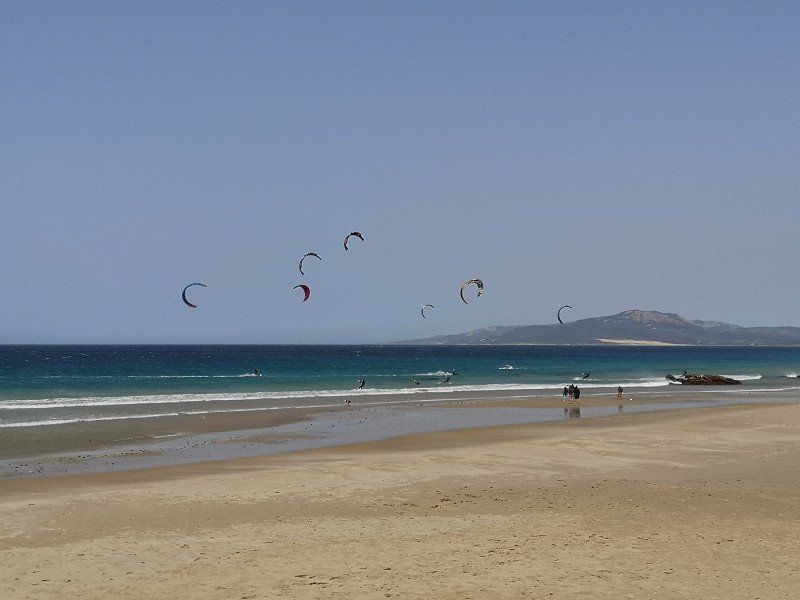
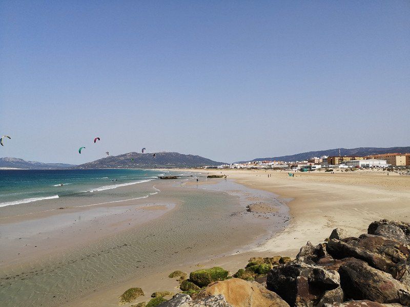
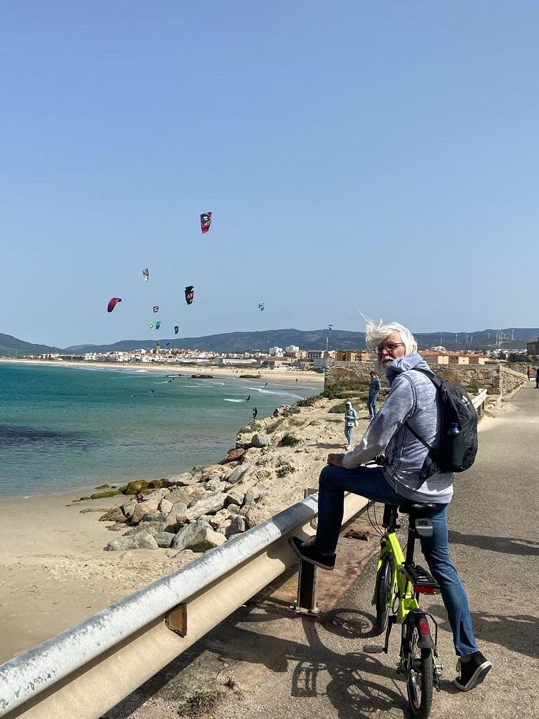
Simple campsite right by the sea, a bit expensive, suitable for kite surfers (very windy)
C.N. Cádiz-málaga, 11380, Tarifa, Spanien
36° 2' 37" N 5° 37' 50" W
36.0436100 -5.6305500
• Head east on N-340. Go for 3.9 km.
• Take the 2nd exit from roundabout onto N-340 toward Algeciras/Málaga. Go for 438 m.
• Arrive at N-340.
☍
4,3 km
( 3 min.)
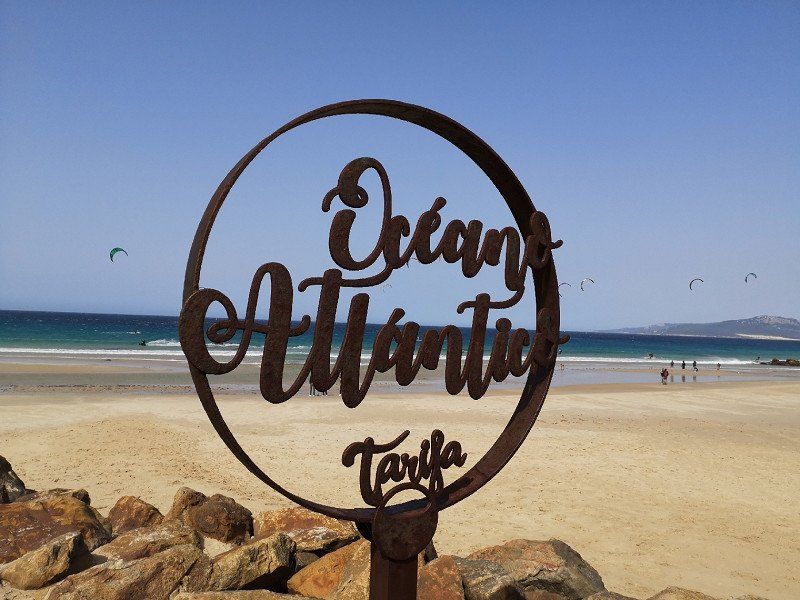
Tarifa
2CG3+PX Tarifa, Spanien
36° 1' 36.5" N 5° 35' 42" W
36.0267985 -5.5950124
• Head east on N-340. Go for 912 m.
• Turn sharp left toward Vejer de la Frontera/Cádiz. Go for 193 m.
• Turn right onto N-340 toward Vejer de la Frontera/Cádiz. Go for 871 m.
• Keep right onto N-340 toward Vejer de la Frontera/Cádiz. Go for 47.9 km.
• Pass 2 roundabouts and continue on N-340. Go for 1.8 km.
• Continue on A-48 (Autovía de la Costa de la Luz) toward Vejer de la Frontera/A-2229/Los Caños de Meca/A-2233. Go for 201 m.
• Take exit 36 toward Vejer de la Frontera/A-2229/Los Caños de Meca/A-2233. Go for 406 m.
• Take the 4th exit from roundabout toward A-2229/Vejer/A-2233/Los Caños de Meca/N-340/Algeciras/Málaga/El Palmar. Go for 263 m.
• Take the 2nd exit from roundabout toward Vejer/A-2229/Los Caños de Meca/A-2233/El Palmar. Go for 237 m.
• Take the 5th exit from roundabout onto A-2229. Go for 1.8 km.
• Continue on Calle Los Remedios (A-2229). Go for 244 m.
• Take the 2nd exit from roundabout onto Calle Los Remedios. Go for 77 m.
• Turn right onto Avenida de Andalucía. Go for 291 m.
• Turn left onto Calle San Ambrosio. Go for 144 m.
• Turn right onto Callejón Corchero. Go for 79 m.
• Turn right onto Calle Bellido. Go for 43 m.
• Turn left onto Calle Santiago. Go for 36 m.
• Turn right onto Calle Santiago. Go for 26 m.
• Turn left onto Calle Juan de Sevilla. Go for 82 m.
• Arrive at Calle Juan de Sevilla. Your destination is on the left.
☍
55,5 km
( 42 min.)
Day
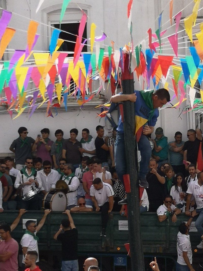
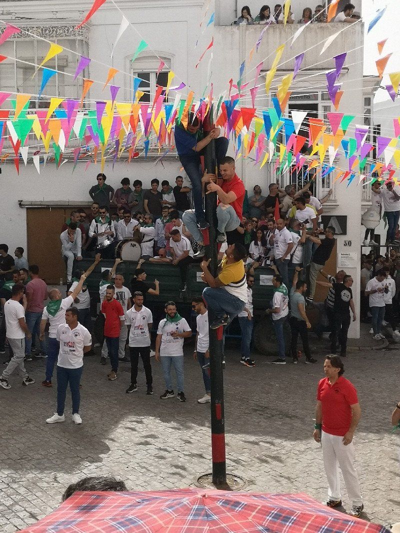
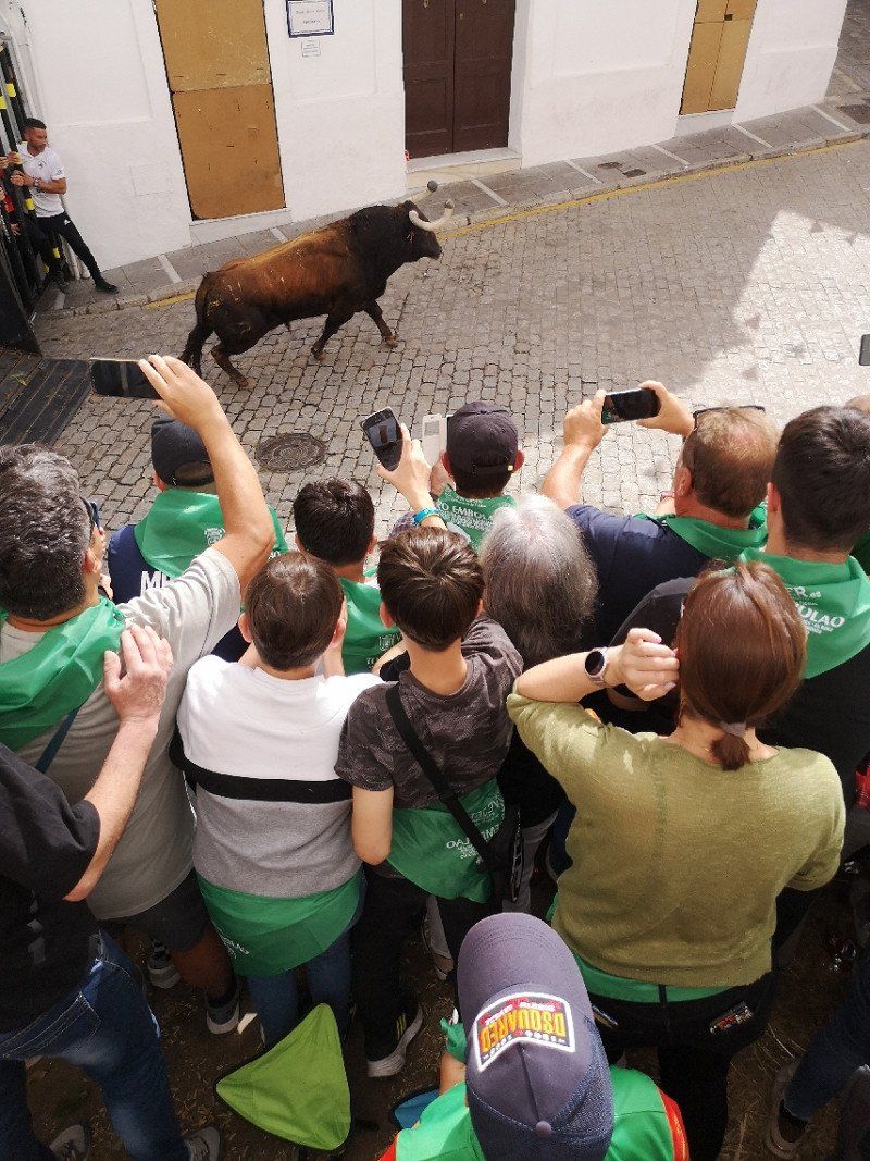
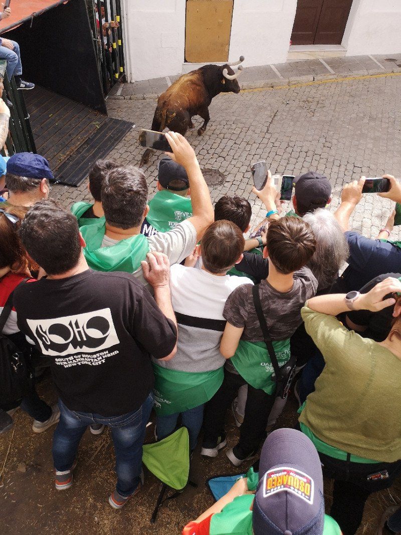
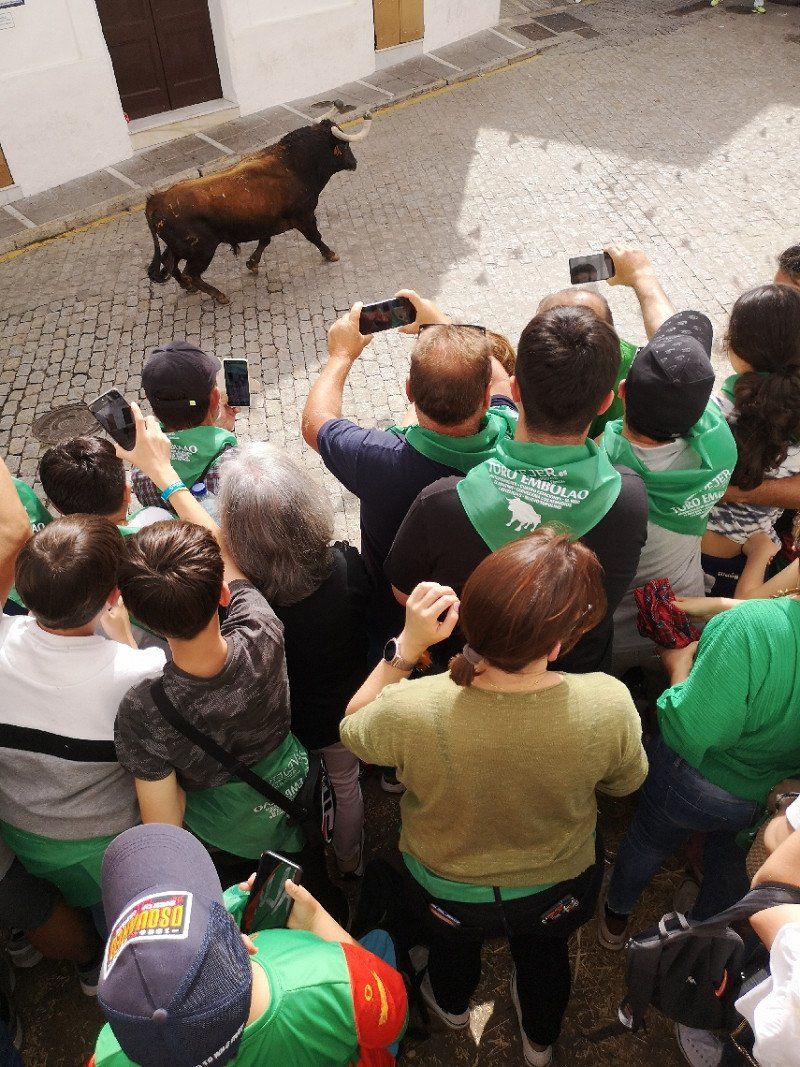
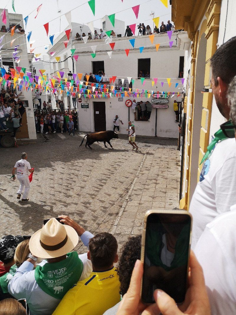
Vejer de la Frontera
Wonderful old town, we were lucky enough to watch the Fiesta del Toro Embolao from a car on Easter Sunday... Great timing and totally bloodless
Spanien
36° 15' 7.3" N 5° 58' 0.2" W
36.2520340 -5.9667359
• Head toward Calle Juan Belinque on Calle Juan de Sevilla. Go for 16 m.
• Turn sharp right onto Calle Juan Belinque. Go for 65 m.
• Continue on Avenida de San Miguel. Go for 269 m.
• Turn right onto Avenida de Buenavista. Go for 345 m.
• Turn right onto Avenida de Andalucía. Go for 649 m.
• Turn left onto Calle Los Remedios. Go for 25 m.
• Take the 1st exit from roundabout onto Calle Los Remedios (A-2229). Go for 285 m.
• Continue on A-2229. Go for 1.7 km.
• Take the 2nd exit from roundabout toward La Muela/E-5/A-48/Cadiz/Algeciras. Go for 182 m.
• Take the 3rd exit from roundabout onto N-340. Go for 10.4 km.
• Take the 2nd exit from roundabout onto N-340 toward La Lobita/El Colorado. Go for 116 m.
• Continue on Casas de los García (N-340). Go for 121 m.
• Continue on N-340. Go for 803 m.
• Take the 2nd exit from roundabout onto N-340 toward E-5/Chiclana/Cádiz. Go for 168 m.
• Continue on Casa de Postas (N-340). Go for 41 m.
• Continue on N-340. Go for 1.4 km.
• Pass 2 roundabouts and continue on N-340. Go for 1.0 km.
• Continue on Venta de la Curva (N-340). Go for 53 m.
• Continue on N-340. Go for 893 m.
• Pass 2 roundabouts and continue on N-340. Go for 933 m.
• Take the 3rd exit from roundabout. Go for 315 m.
• Turn left onto CA-3208. Go for 1.9 km.
• Continue on Carril Puente de Tablas. Go for 1.5 km.
• Continue on Carril El Maestro. Go for 182 m.
• Continue on Carril El Maestro. Go for 879 m.
• Turn slightly left. Go for 481 m.
• Turn slightly left. Go for 363 m.
• Arrive at your destination.
☍
25,0 km
( 29 min.)
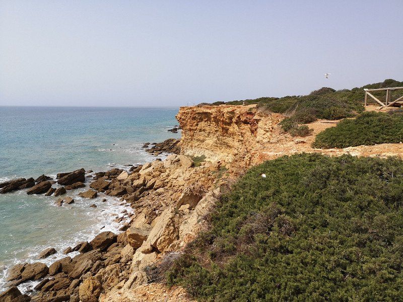
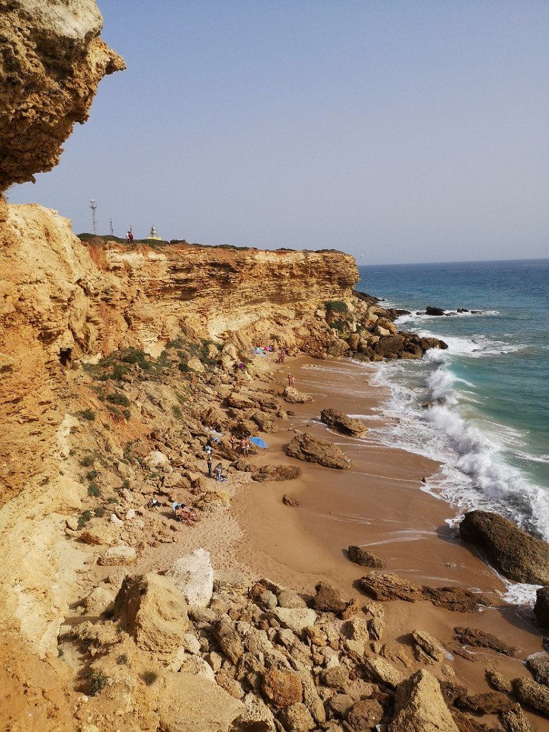
Cabo Roche
Very beautiful cliffs with bathing bays. We stayed right next to the lighthouse.
Spanien
36° 19' 7.6" N 6° 8' 21.4" W
36.3187840 -6.1392650
• Head southwest.
• Turn right. Go for 13 m.
• Turn right toward Venta de los Pinos. Go for 1.2 km.
• Continue on Venta de los Pinos. Go for 335 m.
• Continue on Carretera Urbanización Roche. Go for 76 m.
• Continue on Venta del Chiclanero. Go for 92 m.
• Continue on Calle Colorado. Go for 2.9 km.
• Continue toward El Colorado. Go for 37 m.
• Take the 1st exit from roundabout onto El Colorado. Go for 173 m.
• Take the 3rd exit from roundabout onto N-340. Go for 345 m.
• Pass 2 roundabouts and continue on N-340. Go for 1.9 km.
• Take the 1st exit from roundabout toward E-5/A-48/Algeciras. Go for 74 m.
• Take left ramp onto A-48 (Autovía de la Costa de la Luz) toward Cádiz/Sevilla. Go for 15.8 km.
• Take exit 1 toward Pto. Real/Sevilla/AP-4 onto A-4 (Autovía del Sur). Go for 9.7 km.
• Take exit 658 toward Sevilla onto AP-4 (Autopista del Sur). Go for 89.8 km.
• Continue on A-4 (Autopista del Sur). Go for 13.1 km.
• Take the exit toward Sevilla Centro/Av. de la Raza. Go for 514 m.
• Take the 2nd exit from roundabout onto Avenida de la Raza toward av. de la Raza. Go for 700 m.
• Take the 1st exit from roundabout onto Avenida de la Raza toward Puerto Este/av. de la Raza/Sevilla Centro. Go for 1.5 km.
• Continue on Avenida La Raza. Go for 882 m.
• Turn right onto Calle Cardenal Bueno Monreal. Go for 33 m.
• Turn right onto Calle Cardenal Bueno Monreal. Go for 337 m.
• Turn left onto Avenida Manuel Siurot. Go for 124 m.
• Continue on Avenida de la Borbolla toward Centro Ciudad. Go for 1.2 km.
• Turn slightly left onto Calle Juan de Mata Carriazo. Go for 575 m.
• Continue on Calle José María Moreno Galván. Go for 421 m.
• Turn left onto Calle Luis Montoto. Go for 222 m.
• Arrive at Calle Luis Montoto. Your destination is on the left.
☍
142,0 km
(1 hrs. 30 min.)
Day
Day
Sevilla, Spanien
Sevilla, Provinz Sevilla, Spanien
37° 23' 20.7" N 5° 59' 4.1" W
37.3890924 -5.9844589
• Head northwest on Calle Luis Montoto.
• Turn left onto Avenida Menéndez Pelayo. Go for 121 m.
• Keep left onto Calle La Florida. Go for 146 m.
• Turn right onto Calle Luis Montoto. Go for 117 m.
• Turn left onto Calle Juan Antonio Cavestany. Go for 520 m.
• Turn right toward Avenida José Laguillo. Go for 35 m.
• Turn right onto Avenida José Laguillo. Go for 306 m.
• Take the 5th exit from Glorieta Manuel Barrios roundabout onto Avenida de Kansas City. Go for 2.7 km.
• Continue on Avenida de Averroes. Go for 710 m.
• Continue on A-4 (Nudo Gota de Leche). Go for 126 km.
• Take exit 409B toward Córdoba (Oeste)/Aeropuerto onto CO-32. Go for 5.6 km.
• Take the 1st exit from roundabout onto Avenida del Aeropuerto (N-437) toward Córboba/Córdoba. Go for 821 m.
• Take the 2nd exit from roundabout onto Avenida del Aeropuerto (N-437) toward Centro Ciudad. Go for 2.0 km.
• Turn slightly left onto Glorieta Cruz Roja toward Centro Ciudad. Go for 87 m.
• Take the 1st exit from roundabout onto Glorieta Cruz Roja toward Centro Ciudad. Go for 131 m.
• Continue on Paseo de la Victoria. Go for 554 m.
• Turn slightly right onto Avenida Ronda de los Tejares toward Centro Ciudad/Plaza de Colón. Go for 499 m.
• Turn right onto Calle Caño. Go for 73 m.
• Turn left onto Calle Manuel María de Arjona. Go for 56 m.
• Arrive at Calle Manuel María de Arjona. Your destination is on the left.
☍
140,4 km
(1 hrs. 29 min.)
Day
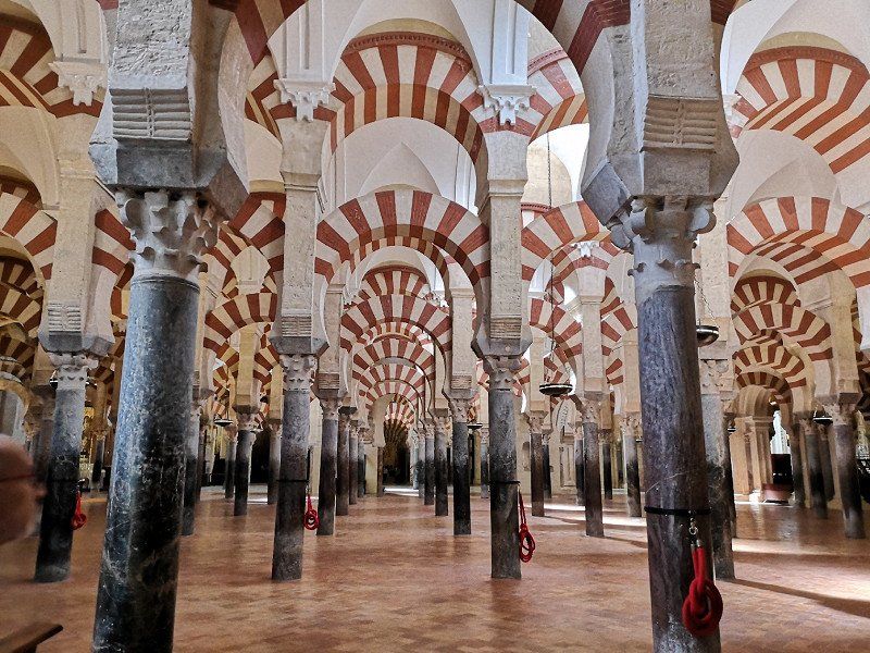
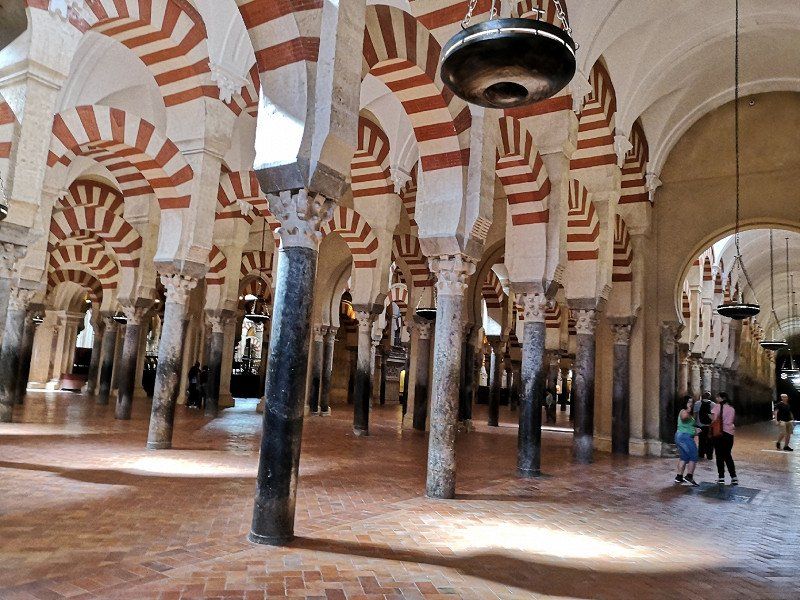
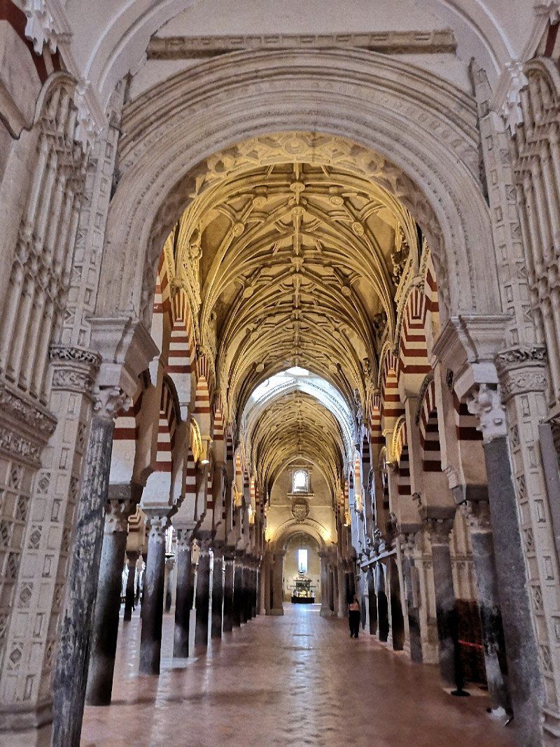
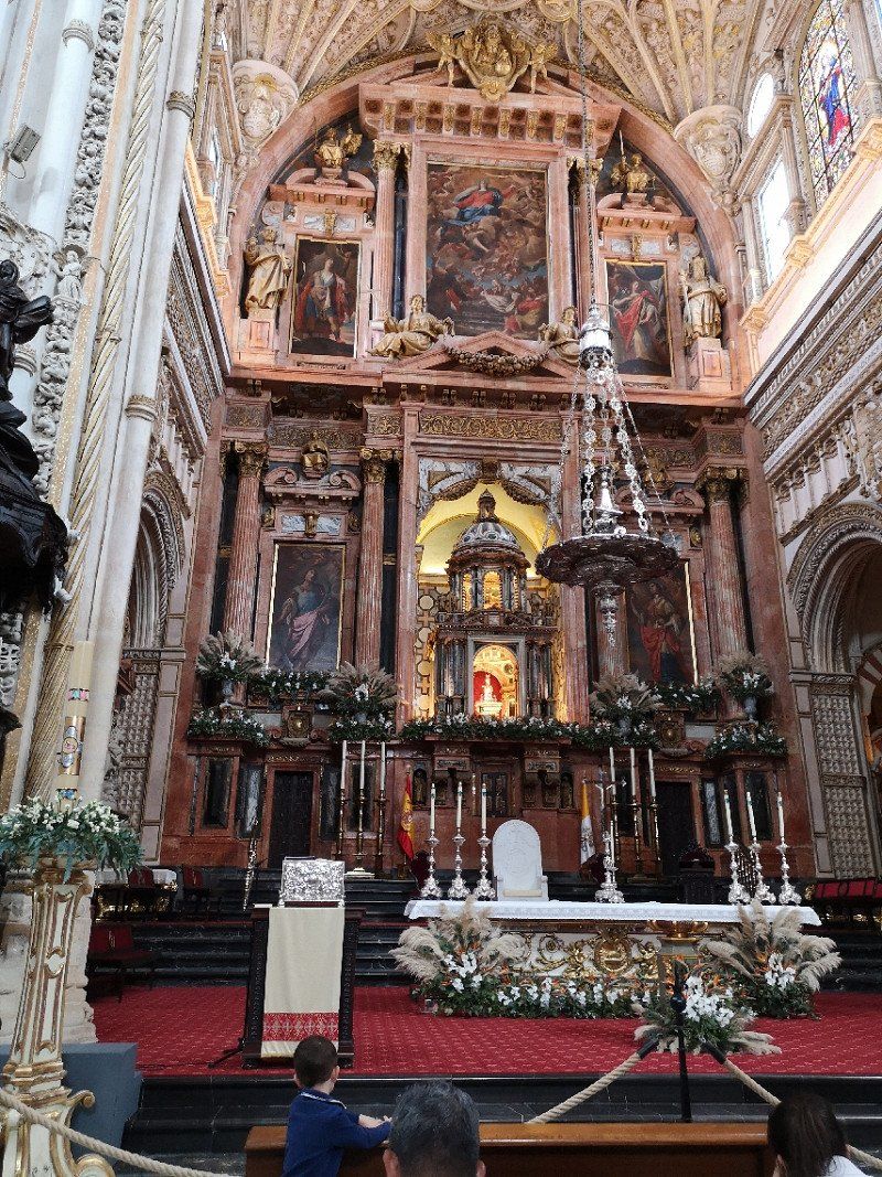
Córdoba
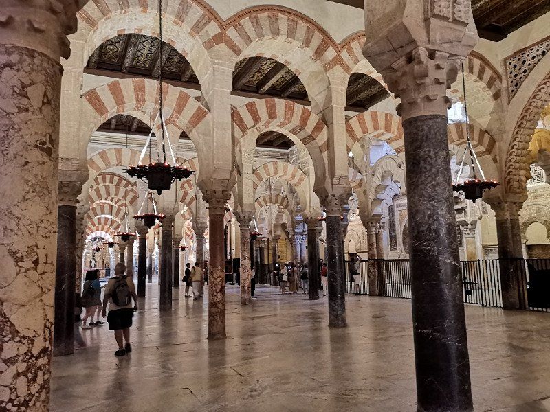
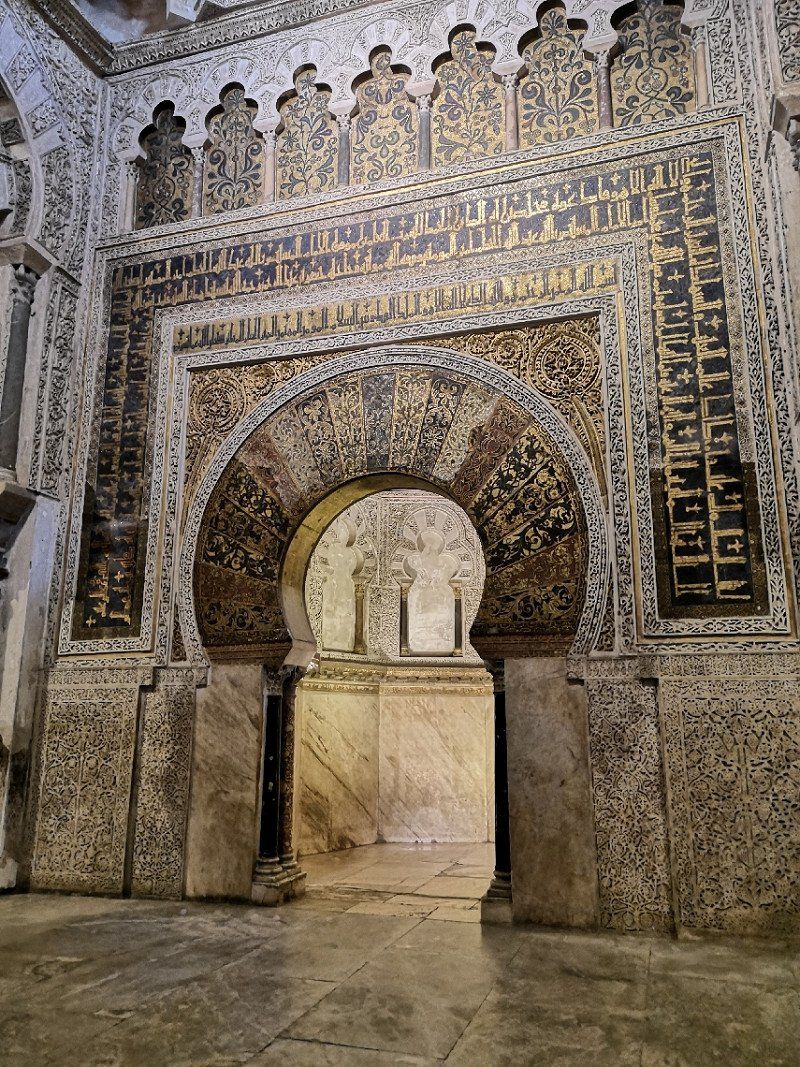
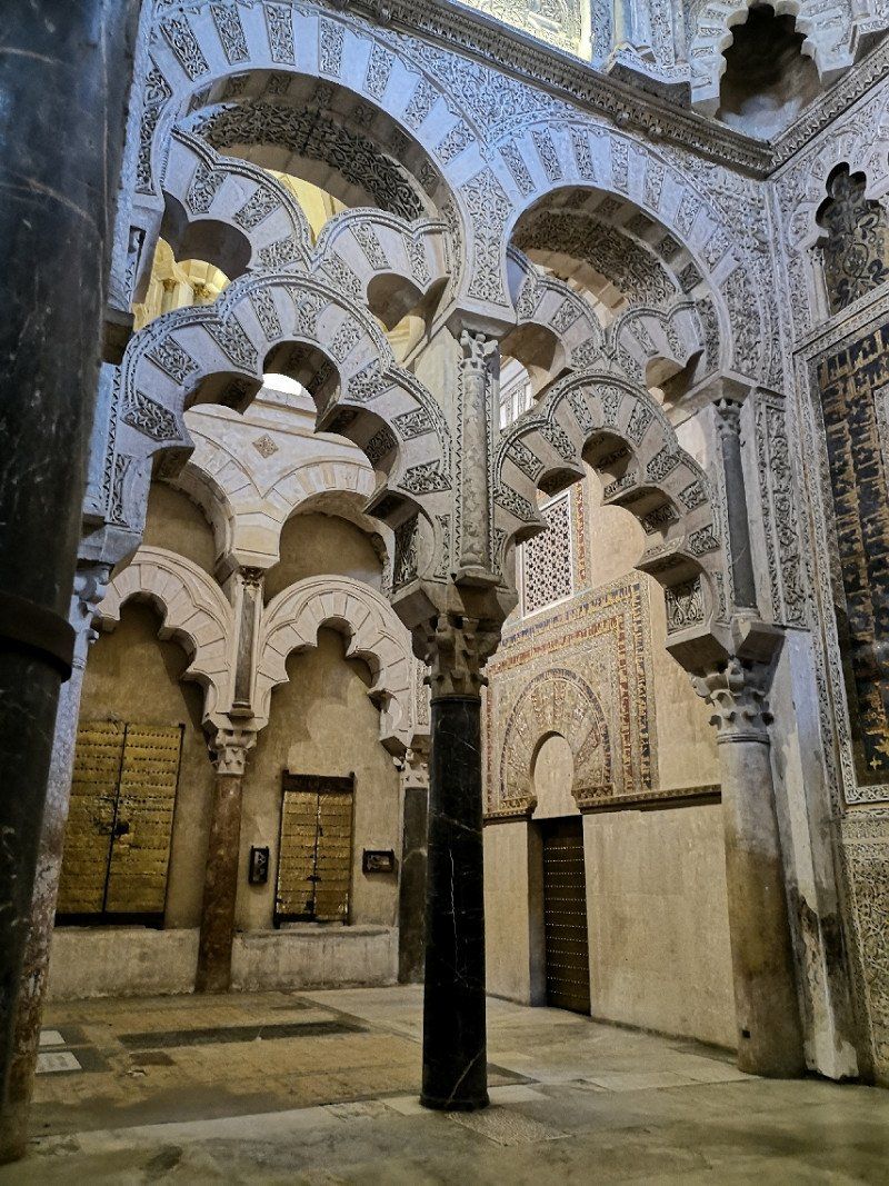
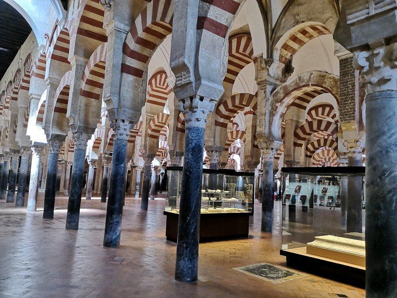
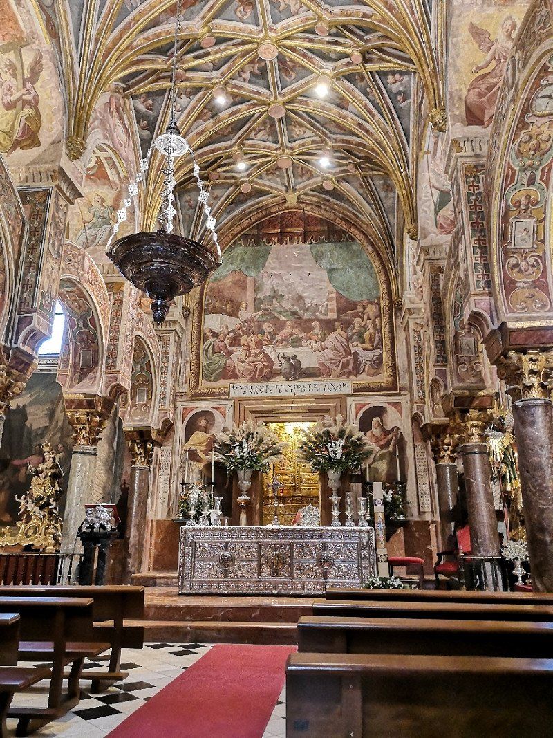
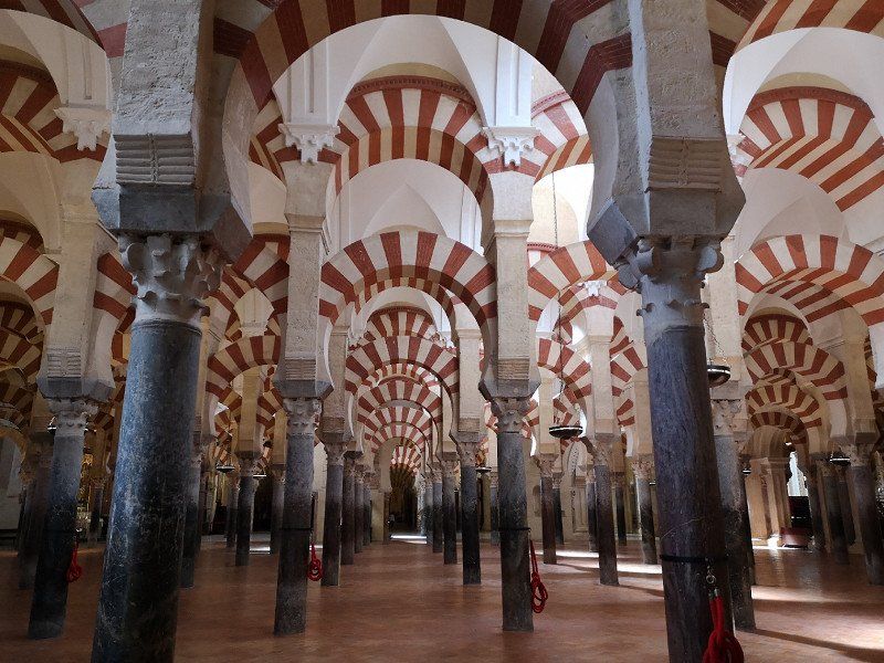
Mezquita very worth seeing
Spanien
37° 53' 17.4" N 4° 46' 45.8" W
37.8881751 -4.7793835
• Head east on Calle Manuel María de Arjona.
• Turn left onto Calle Puerta Osario. Go for 136 m.
• Turn right onto Plaza de Colón. Go for 143 m.
• Keep left onto Plaza de Colón. Go for 320 m.
• Turn right onto Avenida de las Ollerías toward Avda. de las Ollerías/Ronda del Marrubial/Madrid/E-5/N-4. Go for 768 m.
• Turn right onto Glorieta de la Fuensantilla toward Avda. de Barcelona. Go for 35 m.
• Turn right onto Calle Ronda del Marrubial toward Avda. de Barcelona. Go for 295 m.
• Continue on Avenida de Barcelona. Go for 671 m.
• Turn right onto Calle Campo de San Antón toward Estadio Municipal El Arcángel. Go for 376 m.
• Continue on Calle Campo Madre de Dios. Go for 373 m.
• Continue on Ronda de los Mártires. Go for 91 m.
• Continue on Avenida Compositor Rafael Castro. Go for 868 m.
• Take ramp onto A-4 (Autovía Ronda de Córdoba) toward Granada/N-432/Sevilla/Málaga. Go for 47.4 km.
• Take exit 450 toward N-4A/Écija/A-453/Palma del Río/SE-9105/Lucena onto Carretera Antigua N-IV. Go for 2.9 km.
• Take the 2nd exit from roundabout onto Carretera Antigua N-IV toward Écija Centro/Écija/Centro. Go for 285 m.
• Take the 2nd exit from roundabout onto Plaza de Gilés y Rubio. Go for 187 m.
• Continue on Calle General Weyler. Go for 190 m.
• Continue on Calle Comedias. Go for 170 m.
• Continue on Calle de Garcilaso. Go for 151 m.
• Continue on Calle Recogidas. Go for 74 m.
• Turn right onto Calle Eslava. Go for 25 m.
• Turn slightly left onto Calle Secretario Armesto. Go for 166 m.
• Turn left onto Calle La Marquesa. Go for 29 m.
• Arrive at Calle La Marquesa. Your destination is on the right.
☍
55,7 km
( 44 min.)
Day
Écija
small town with a quiet town center and many pretty churches, few tourists... relaxed day
Spanien
37° 32' 29.3" N 5° 4' 57.6" W
37.5414656 -5.0826742
• Head toward Calle del Conde on Calle La Marquesa. Go for 125 m.
• Turn left onto Calle del Conde. Go for 8 m.
• Turn right onto Calle Santa Ángela de la Cruz. Go for 302 m.
• Continue on Plazuela Puerta Osuna. Go for 35 m.
• Turn right onto Calle Cava. Go for 23 m.
• Continue on Calle Hospital. Go for 141 m.
• Continue on Calle Empedrada. Go for 119 m.
• Turn left onto Calle Cañaveralejo. Go for 92 m.
• Take the 2nd exit from roundabout onto Calle San Benito. Go for 469 m.
• Take the 1st exit from roundabout onto Avenida del Genil toward Sevilla/E-5/Córboba/A-4. Go for 276 m.
• Take the 2nd exit from roundabout onto A-4 (Autovía del Sur) toward Sevilla. Go for 80.0 km.
• Continue on Nudo Gota de Leche toward Centro Ciudad Sevilla/avd. Kansas City/Estación de Santa Justa. Go for 368 m.
• Take the exit toward Ronda Urbana Norte/Sevilla Norte/E-803/Mérida/A-66 onto SE-30 (Nudo Gota de Leche). Go for 4.2 km.
• Take the 2nd exit from Glorieta Olímpica roundabout onto SE-30 (Puente El Alamillo) toward Huelva/E-1/A-49/Mérida/E-803/N-630/Isla de la Cartuja/Estadio Olímpico. Go for 3.7 km.
• Take the exit toward A-49/Huelva/E-5/A-4/Cádiz onto A-66 (Autovía de la Plata). Go for 2.9 km.
• Take exit 17C toward Camas onto A-49 (Autopista del V Centenario). Go for 47.6 km.
• Take exit 48 toward Almonte onto A-483. Go for 25.0 km.
• Take the 2nd exit from roundabout onto A-483 toward Centro Ciudad El Rocío/Matalascañas. Go for 2.3 km.
• Take exit 2 toward El Rocío. Go for 384 m.
• Take the 2nd exit from roundabout toward A-483/Almonte/El Rocío. Go for 188 m.
• Take the 2nd exit from roundabout. Go for 533 m.
• Take the 1st exit from roundabout onto A-483. Go for 351 m.
• Take the 3rd exit from roundabout onto Calle El Ajolí. Go for 551 m.
• Turn left onto Calle La Cigüeña. Go for 51 m.
• Turn right toward Via de Servicio. Go for 161 m.
• Continue on Via de Servicio. Go for 533 m.
• Arrive at your destination on the left.
☍
170,4 km
(1 hrs. 50 min.)
El Rocío
Spanien
37° 8' 1.4" N 6° 28' 46.8" W
37.1337088 -6.4796528
• Head toward Calle Camino de los Tarajales. Go for 67 m.
• Turn right onto Calle Camino de los Tarajales. Go for 44 m.
• Turn right onto Calle El Ajolí. Go for 1.2 km.
• Turn slightly left onto Calle El Ajolí. Go for 30 m.
• Take the 1st exit from roundabout onto A-483. Go for 279 m.
• Take the 3rd exit from roundabout. Go for 601 m.
• Take the 3rd exit from roundabout toward A-483/Matalascañas. Go for 170 m.
• Take the 1st exit from roundabout toward Matalascañas. Go for 461 m.
• Continue on A-483. Go for 14.9 km.
• Keep left onto A-483. Go for 224 m.
• Take the 3rd exit from roundabout onto Carretera Norte. Go for 456 m.
• Take the 2nd exit from roundabout onto Carretera Norte. Go for 243 m.
• Take the 1st exit from roundabout onto Ronda del Sector Gallareta. Go for 284 m.
• Continue on Ronda del Sector Gallareta. Go for 234 m.
• Continue on Ronda del Pintor Goya. Go for 279 m.
• Turn left onto Avenida del Pintor Romero de Torres. Go for 233 m.
• Turn right onto Avenida Maestro Luna. Go for 77 m.
• Turn right onto Avenida Maestro Luna. Go for 55 m.
• Turn left onto Ronda Maestro Guerrero. Go for 160 m.
• Turn left toward Calle M. Go for 91 m.
• Continue on Calle M. Go for 145 m.
• Continue toward Calle M. Go for 106 m.
• Turn slightly right onto Calle M. Go for 423 m.
• Take the 3rd exit from roundabout onto Calle M. Go for 182 m.
• Arrive at Calle M. Your destination is on the left.
☍
20,9 km
( 25 min.)
Day
Matalascañas
2 nights on the simple pitch at Oskar. €10 on weekdays and €15 on weekends, no electricity and no waste disposal, but right on the beach. Beach bar (food expensive and bad) right next to it can also be annoying.
Spanien
36° 59' 53.7" N 6° 33' 5.8" W
36.9982536 -6.5516206
• Head north on Calle M. Go for 279 m.
• Turn right. Go for 24 m.
• Turn right toward Avenida del Compositor Falla. Go for 111 m.
• Turn left onto Avenida del Compositor Falla. Go for 103 m.
• Turn left onto Avenida del Compositor Falla. Go for 740 m.
• Take the 3rd exit from roundabout onto Avenida del Pintor Murillo. Go for 296 m.
• Turn slightly right onto Avenida del Pintor Murillo. Go for 448 m.
• Turn right onto Ronda del Sector Gallareta. Go for 18 m.
• Take the 2nd exit from roundabout onto Carretera Norte. Go for 274 m.
• Take the 1st exit from roundabout onto Carretera Norte. Go for 351 m.
• Pass 3 roundabouts and continue on A-494. Go for 28.4 km.
• Take the 2nd exit from roundabout onto N-442 toward Huelva. Go for 7.5 km.
• Pass 2 roundabouts and continue on N-442. Go for 5.8 km.
• Continue on Carretera de Ferrocarril (H-30). Go for 47 m.
• Keep right onto Carretera de Ferrocarril (H-30). Go for 10.8 km.
• Take the 1st exit from roundabout onto H-30 toward Gibraleón/Portugal. Go for 967 m.
• Take the 2nd exit from roundabout onto H-30 toward Gibraleón/Portugal. Go for 4.6 km.
• Take the 3rd exit from roundabout onto H-30 toward Gibraleón/Portugal/Sevilla/A-49. Go for 1.4 km.
• Take the 2nd exit from roundabout onto H-30 toward Gibraleón/Portugal/A-49/Sevilla. Go for 1.4 km.
• Take ramp onto A-49 (Autopista del V Centenario) toward Portugal. Go for 45.5 km.
• Continue on A22 (Via Infante de Sagres). Go for 8.9 km.
• Take exit 17 toward Monte Gordo/(N125). Go for 2.2 km.
• Continue toward N125. Go for 42 m.
• Take the 1st exit from roundabout onto N125. Go for 285 m.
• Pass 7 roundabouts and continue on N125. Go for 14.8 km.
• Keep left toward M508. Go for 56 m.
• Take the 3rd exit from roundabout onto M508. Go for 117 m.
• Continue on Rua Álvaro de Campos (M508). Go for 136 m.
• Turn left onto Avenida Zeca Afonso. Go for 56 m.
• Arrive at Avenida Zeca Afonso. Your destination is on the left.
☍
135,6 km
(1 hrs. 38 min.)
Day
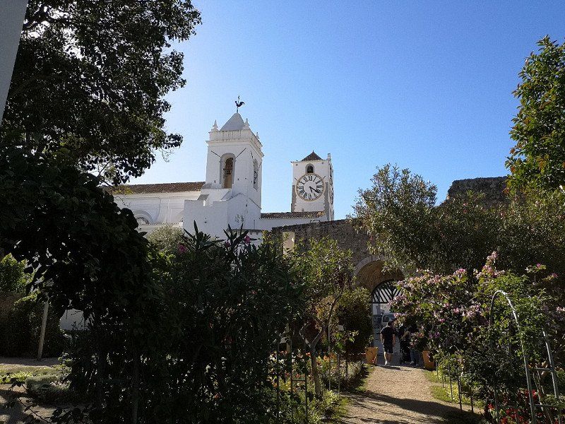
Tavira
Small town, but not nearly as attractive as described in some travel guides
Portugal
37° 8' 0.9" N 7° 38' 34.8" W
37.1335906 -7.6430019
• Head toward Rua Álvaro de Campos on Avenida Zeca Afonso. Go for 56 m.
• Turn right onto Rua Álvaro de Campos (M508). Go for 136 m.
• Continue on M508. Go for 24 m.
• Take the 3rd exit from roundabout onto N125. Go for 2.4 km.
• Take the 2nd exit from roundabout onto N270. Go for 3.7 km.
• Take the 2nd exit from roundabout toward Lisboa/Faro/Espanha. Go for 174 m.
• Take left ramp onto A22 (Via Infante de Sagres) toward Lisboa/Faro. Go for 10.9 km.
• Take exit 15 toward Olhão. Go for 648 m.
• Take the 1st exit from roundabout onto N398 toward Olhão. Go for 7.5 km.
• Take the 2nd exit from roundabout onto N125. Go for 1.5 km.
• Take the 2nd exit from roundabout onto Avenida Dom João VI (N125). Go for 447 m.
• Take the 3rd exit from roundabout onto Avenida Bernardino Silva. Go for 503 m.
• Continue on Avenida da República. Go for 327 m.
• Turn right onto Rua Diogo Mendonça Corte Real. Go for 52 m.
• Turn left onto Rua Gonçalo Velho. Go for 323 m.
• Turn left onto Travessa Heliodoro Salgado. Go for 47 m.
• Turn slightly right onto Travessa da Trindade. Go for 39 m.
• Arrive at Travessa da Trindade. Your destination is on the right.
☍
28,8 km
( 26 min.)
Olhão
Portugal
37° 1' 33.7" N 7° 50' 32.5" W
37.0260416 -7.8423509
• Head toward Travessa Luís Camões on Travessa da Trindade. Go for 47 m.
• Turn right onto Rua Padre António Joaquim Trindade. Go for 25 m.
• Turn right onto Rua Dr. António Batista Delgado. Go for 54 m.
• Turn right onto Rua Dr. Miguel Bombarda. Go for 94 m.
• Continue on Travessa do Faro. Go for 49 m.
• Continue on Rua Faro. Go for 75 m.
• Turn right onto Rua Moinho da Barreta. Go for 42 m.
• Turn left onto Praça João Deus. Go for 41 m.
• Turn right onto Rua Dr. Alberto Iria. Go for 52 m.
• Turn left onto Travessa Feira. Go for 14 m.
• Turn right onto Rua da Feira. Go for 100 m.
• Continue on Rua da Feira. Go for 559 m.
• Turn right onto Avenida 5 de Outubro. Go for 128 m.
• Take the 2nd exit from roundabout onto N125. Go for 2.2 km.
• Take the 1st exit from roundabout onto N125. Go for 2.1 km.
• Take the 2nd exit from roundabout onto N125 toward Faro. Go for 3.8 km.
• Continue on N125-10. Go for 1.5 km.
• Take ramp onto IC4 toward A22/Loulé/Lisboa/Portimão/Albufeira/IP1. Go for 4.4 km.
• Keep left onto IC4 toward Espanha/A22/Albufeira/Lisboa/A2/Loulé/Estádio Algarve. Go for 2.7 km.
• Take ramp onto N125 toward Portimão/Albufeira. Go for 5.9 km.
• Pass 7 roundabouts and continue on N125. Go for 8.3 km.
• Take the 2nd exit from roundabout onto M526. Go for 3.4 km.
• Turn left onto Estrada de Vale Carro. Go for 939 m.
• Turn left onto Caminho da Várzea. Go for 421 m.
• Turn right onto Caminho Banco. Go for 214 m.
• Turn right onto Caminho do Banco. Go for 43 m.
• Turn left onto Rua dos Foros. Go for 777 m.
• Turn left onto Estrada do Alfa-Mar. Go for 914 m.
• Turn left onto Estrada da Rocha Baixinha. Go for 2.6 km.
• Arrive at Estrada da Rocha Baixinha.
☍
41,3 km
( 53 min.)
Day
Day
Day
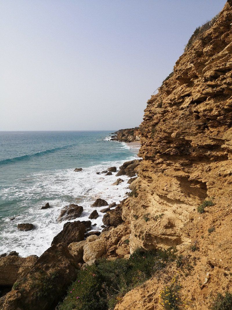
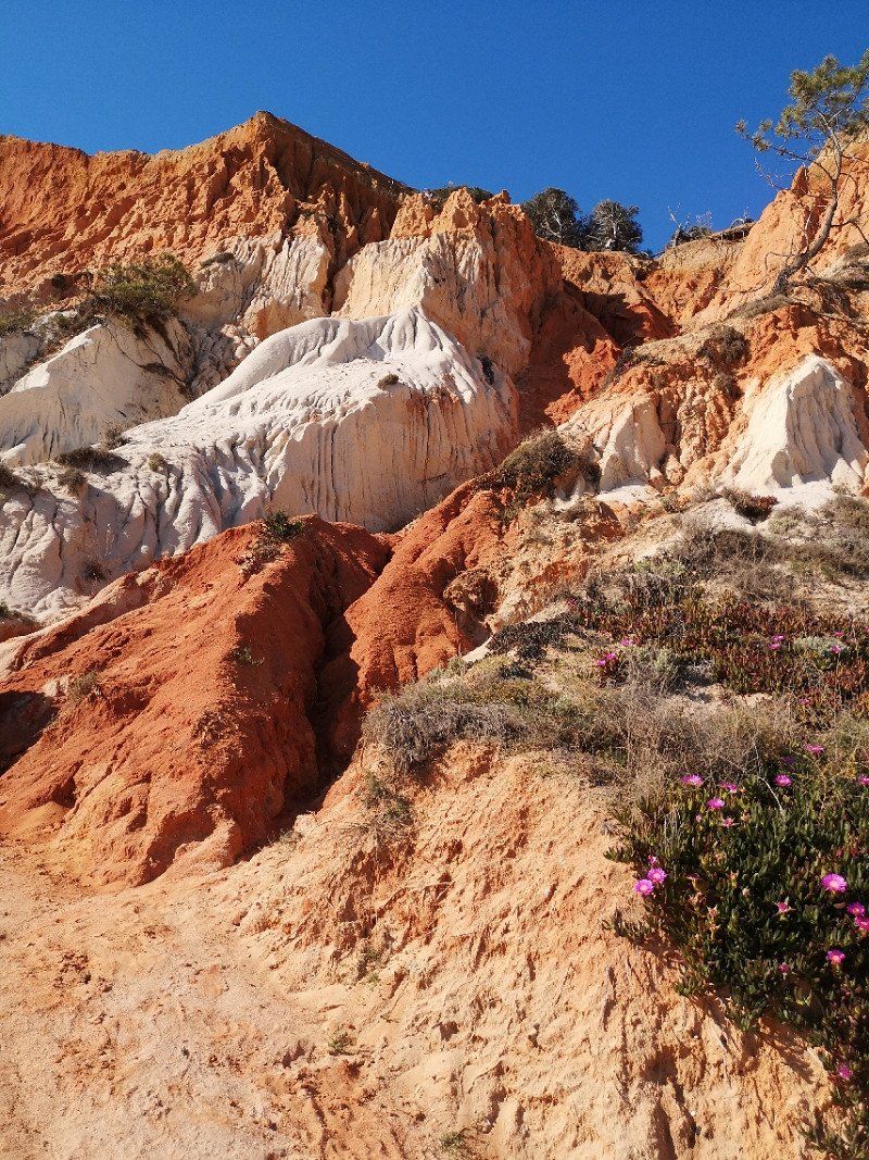
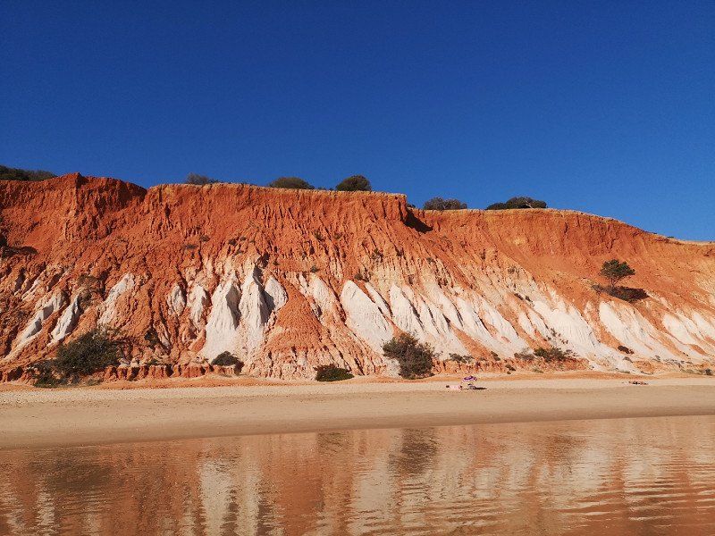
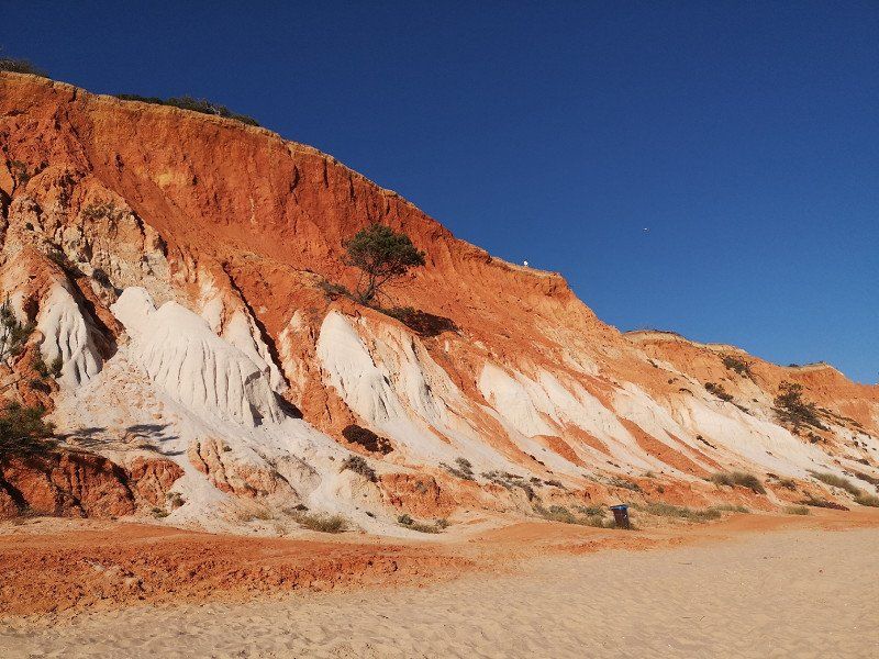
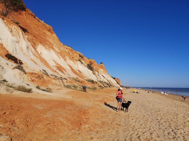
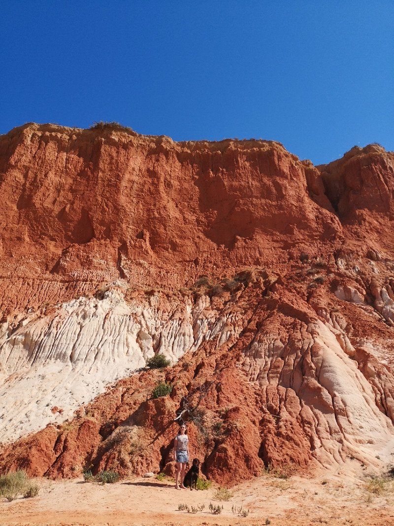
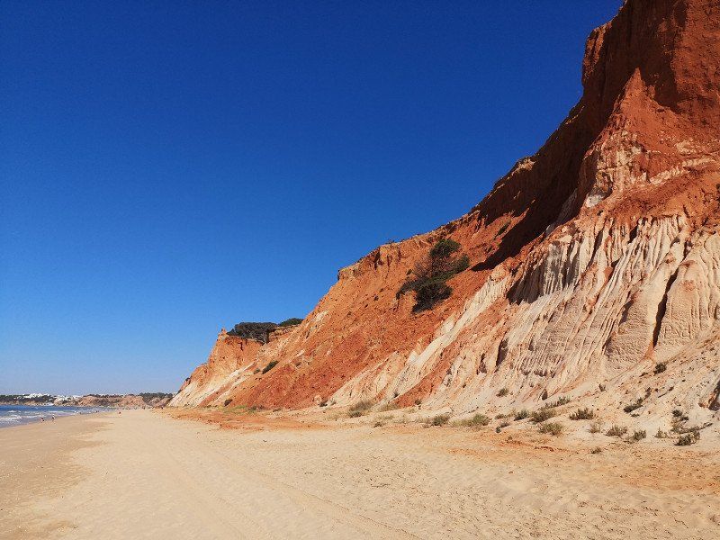
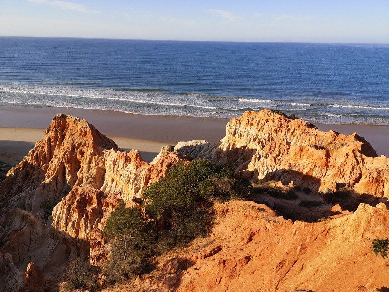
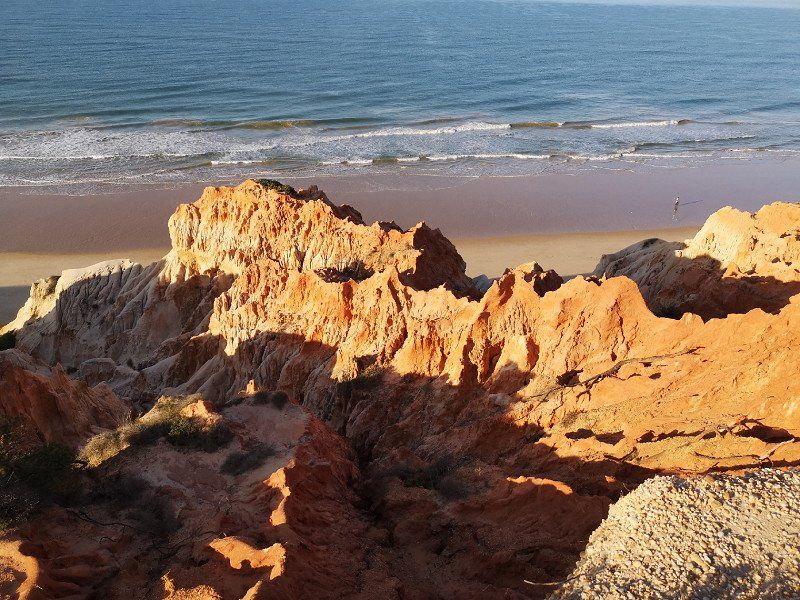
Praia da Falésia, Portugal
Praia da Falesia
You should definitely pay a visit to another beach: Praia da Falésia. This stretches over six kilometers between Olhos de Água and Vilamoura, making it the longest in the Algarve. The steep coast, which shimmers reddish, copper-colored or golden depending on the incidence of light, forms the dreamlike background of the huge sandy beach.
To the northwest of the beach, the small fishing village of Olhos de Agua is a peaceful little town with a wide range of restaurants and cafes. Vacationers who long for peace and quiet will get their money's worth here.
37° 4' 33.5" N 8° 8' 3.1" W
37.0759611 -8.1341991
• Head toward Caminho do Poço Velho on Estrada da Rocha Baixinha. Go for 2.6 km.
• Turn right onto Estrada do Alfa-Mar. Go for 914 m.
• Turn right onto Rua dos Foros. Go for 777 m.
• Turn right onto Caminho do Banco. Go for 43 m.
• Turn left toward Caminho Banco. Go for 21 m.
• Continue on Caminho Banco. Go for 193 m.
• Turn left onto Caminho da Várzea. Go for 421 m.
• Turn left onto Estrada de Vale Carro. Go for 1.0 km.
• Take the 1st exit from Rotunda de Vale Carro roundabout onto M1289. Go for 548 m.
• Take the 3rd exit from roundabout onto M526. Go for 3.7 km.
• Pass 2 roundabouts and continue on Avenida dos Descobrimentos (M526). Go for 1.6 km.
• Take the 3rd exit from roundabout onto Avenida dos Descobrimentos (M526) toward Lisboa/A2. Go for 672 m.
• Pass 4 roundabouts and continue on Avenida dos Descobrimentos (M526). Go for 3.5 km.
• Take the 3rd exit from roundabout onto Avenida dos Descobrimentos (M526). Go for 656 m.
• Take the 2nd exit from roundabout onto M526. Go for 169 m.
• Turn right onto Caminho das Sesmarias. Go for 590 m.
• Turn left onto Rua dos Corais. Go for 111 m.
• Turn left onto Rua dos Arrifes. Go for 74 m.
• Turn right onto Rua dos Arrifes. Go for 594 m.
• Arrive at your destination on the right.
☍
18,2 km
( 32 min.)
Day
Day
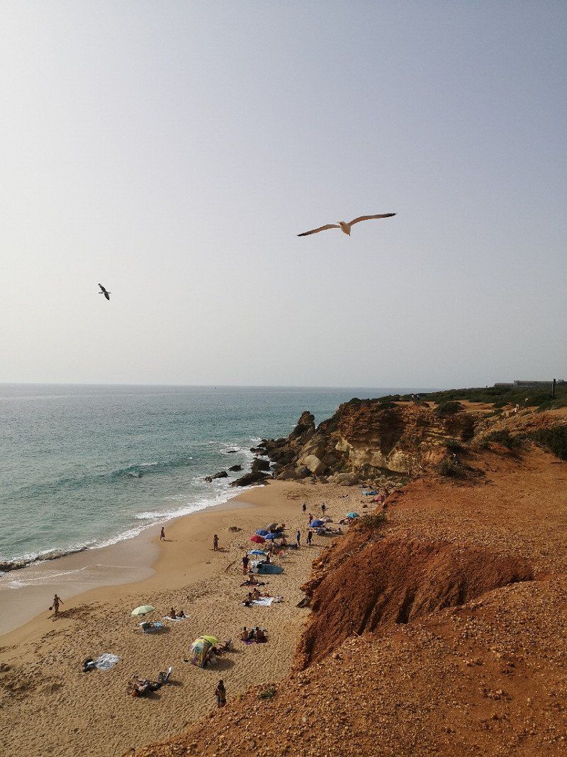
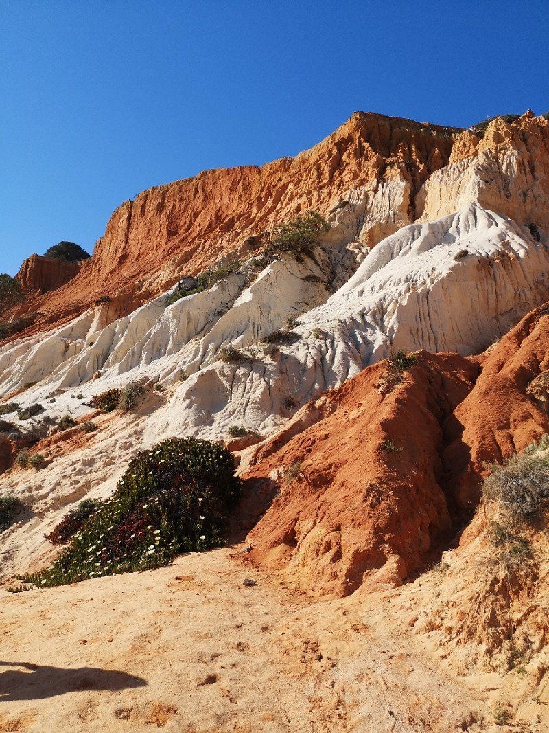
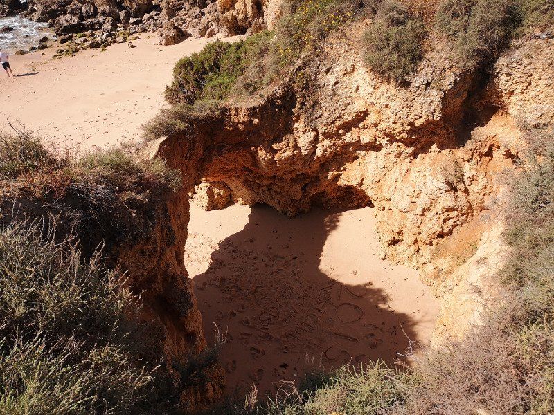
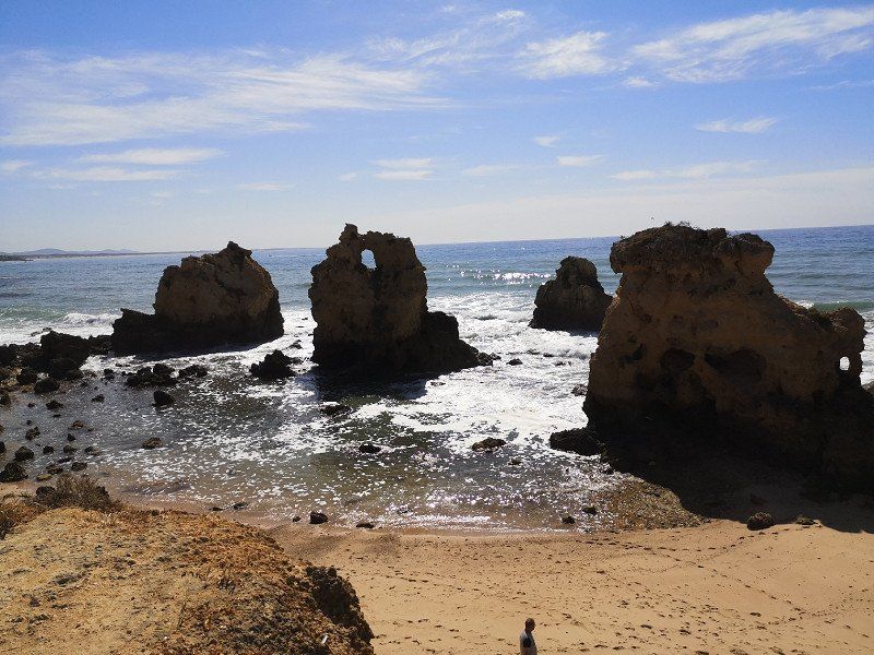
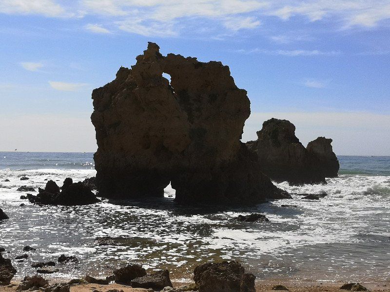
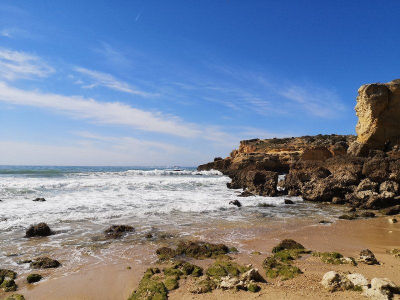
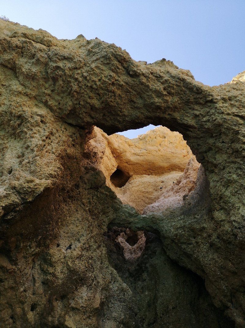
Praia dos Arrifes, Portugal
Praia dos Arrifes
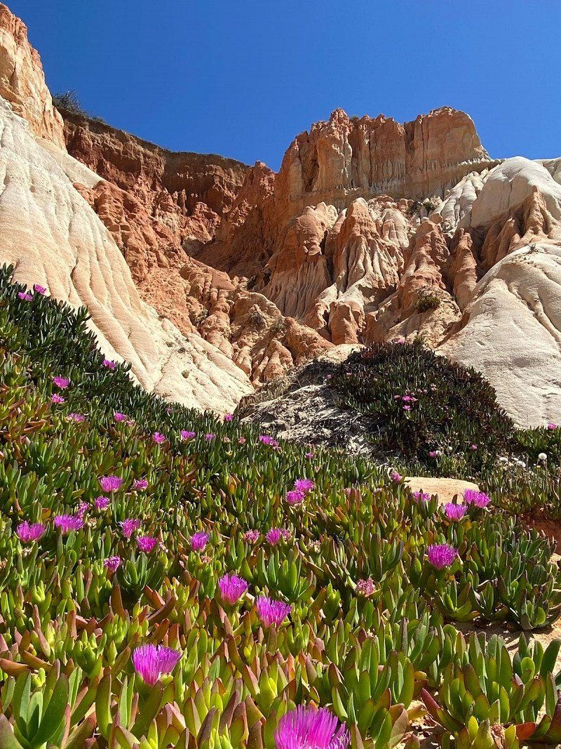
Praia dos Arrifes to the west of Albufeira is one of the smaller beaches but all the more charming. The beach is sheltered from the wind thanks to rock formations with characteristic caves and breakthroughs.
In 2019 you could still drive directly to the cliffs with the motorhome, but unfortunately this is no longer possible. However, the paved parking lot is only a few meters away. It is also worth turning left or right at Praia dos Arrifes. To the left, a path invites you to hike along the cliffs, to the right you reach another enchanting sandy beach.
37° 4' 34" N 8° 16' 38.2" W
37.0761127 -8.2772847
• Head toward Beco da Maré Grande. Go for 151 m.
• Turn slightly right onto Rua dos Arrifes. Go for 443 m.
• Turn left onto Rua dos Arrifes. Go for 74 m.
• Turn right onto Rua dos Corais. Go for 89 m.
• Turn right onto Caminho das Sesmarias. Go for 603 m.
• Turn left onto M526. Go for 133 m.
• Take the 2nd exit from roundabout onto M526. Go for 3.3 km.
• Take the 2nd exit from roundabout onto M526. Go for 2.8 km.
• Take the 1st exit from roundabout onto M526. Go for 1.6 km.
• Continue on Rua Alexandre Herculano. Go for 287 m.
• Turn left onto N125. Go for 567 m.
• Pass 2 roundabouts and continue on N125. Go for 1.4 km.
• Continue toward Via Infante de Sagres/A22. Go for 58 m.
• Take the 1st exit from roundabout onto A22 (Via Infante de Sagres) toward Lagos/Portimão. Go for 35.9 km.
• Take exit 1 toward Vila do Bispo/Sagres/Lagos. Go for 4.7 km.
• Take the 2nd exit from roundabout toward Lagos. Go for 846 m.
• Take the 3rd exit from roundabout onto N125 toward Lagos. Go for 743 m.
• Take the 2nd exit from roundabout onto N125 toward Lagos. Go for 543 m.
• Take the 2nd exit from roundabout onto Avenida das Comunidades Portuguesas (N125) toward Centro. Go for 423 m.
• Turn left onto Rua Doutor Teixeira Gomes. Go for 247 m.
• Take the 2nd exit from roundabout onto Estrada do Biker. Go for 177 m.
• Turn right onto Rua Infante de Sagres. Go for 45 m.
• Turn left onto Rua Infante de Sagres. Go for 14 m.
• Continue on Largo dos Quartéis. Go for 128 m.
• Continue on Rua do Jogo da Bola. Go for 26 m.
• Continue on Rua do Paiol. Go for 75 m.
• Turn left onto Rua dos Peixeiros. Go for 70 m.
• Turn right onto Rua Dr. António José de Almeida. Go for 106 m.
• Arrive at Rua Dr. António José de Almeida. Your destination is on the right.
☍
55,5 km
( 47 min.)
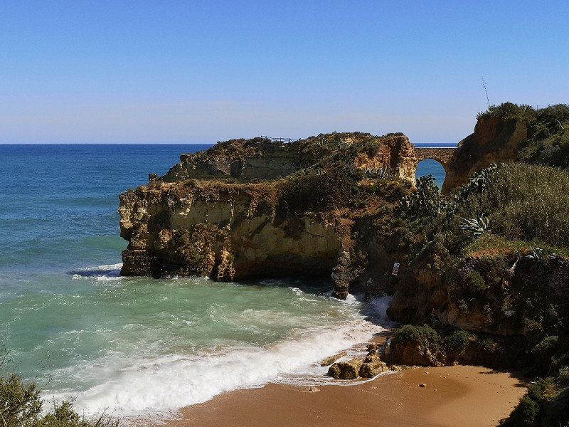
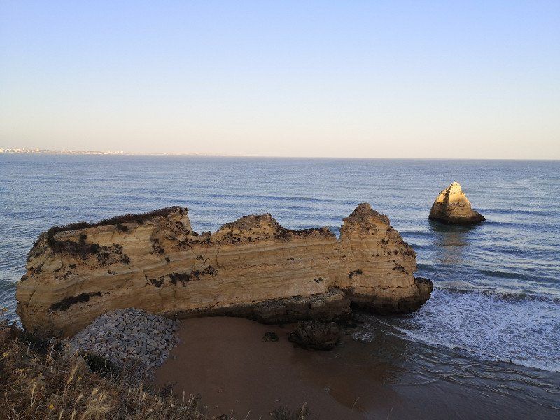
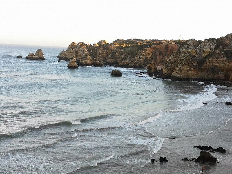
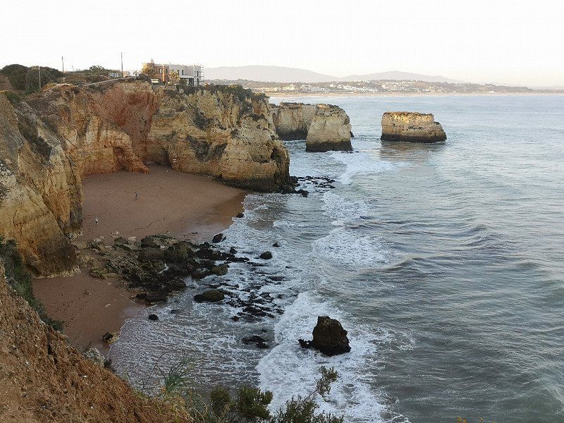
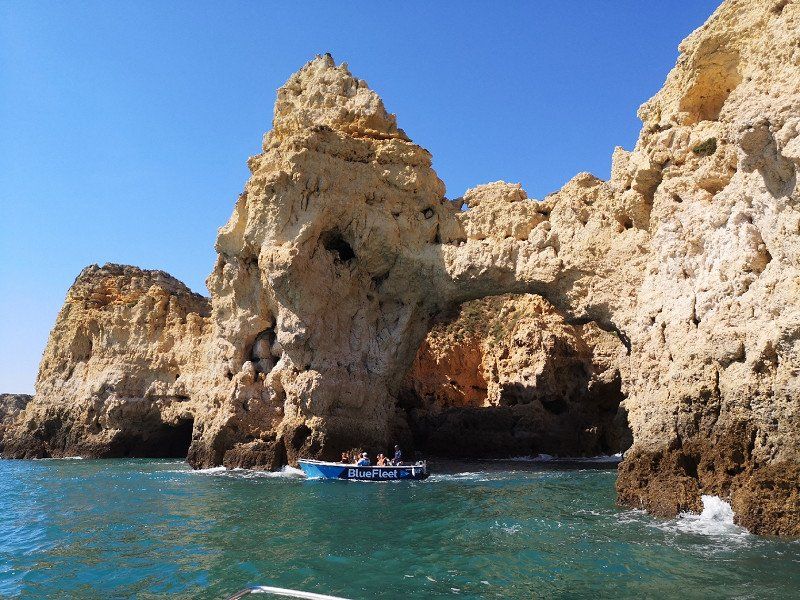
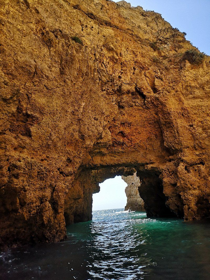
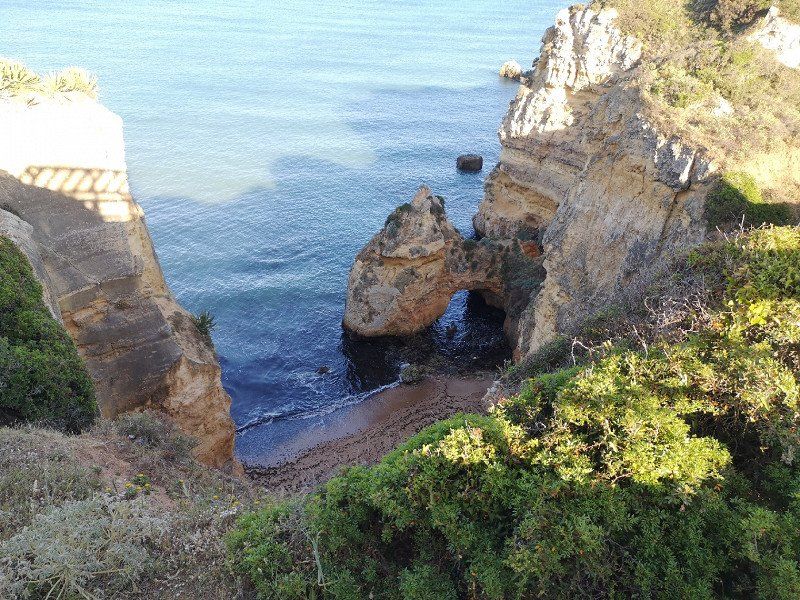
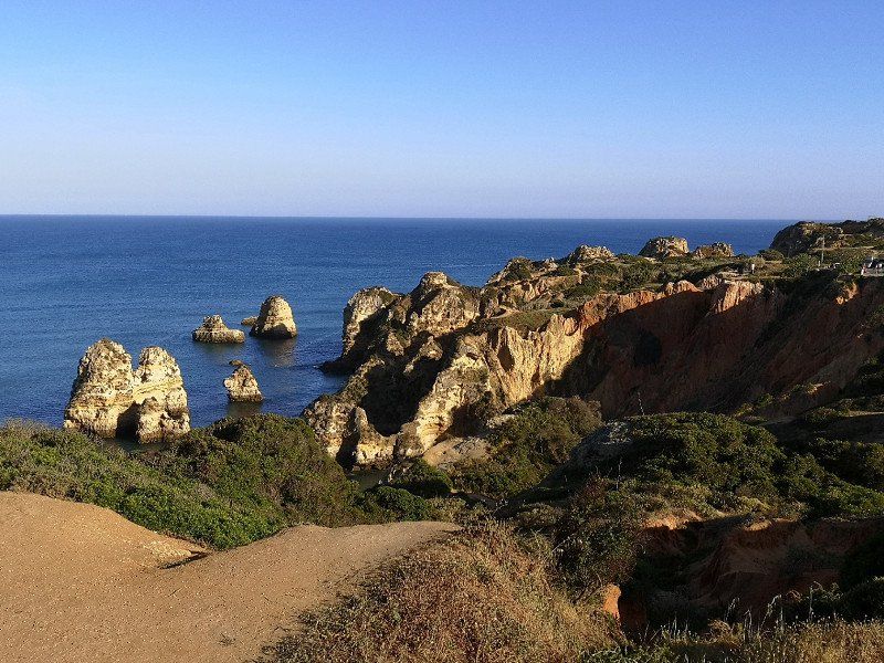
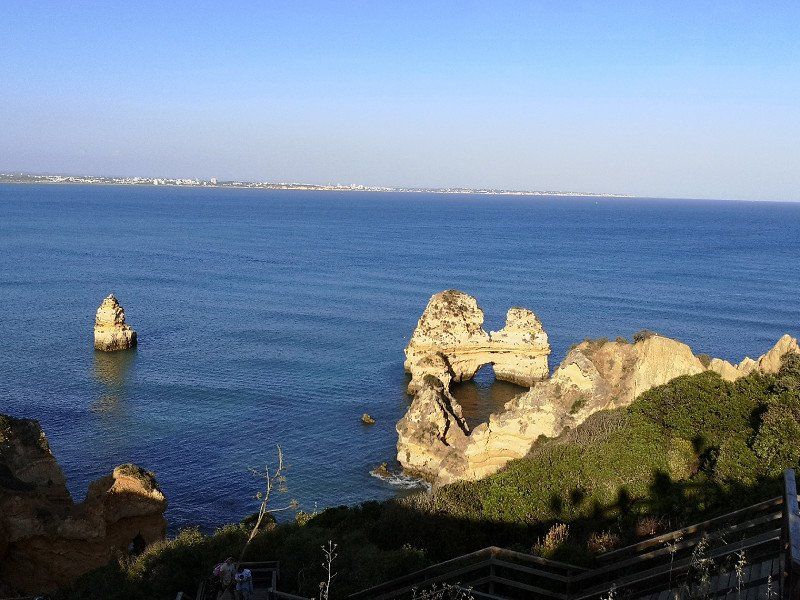
Lagos
The Trindade campsite is a bit dated and very basic, but it is centrally located to the old town and the beach.
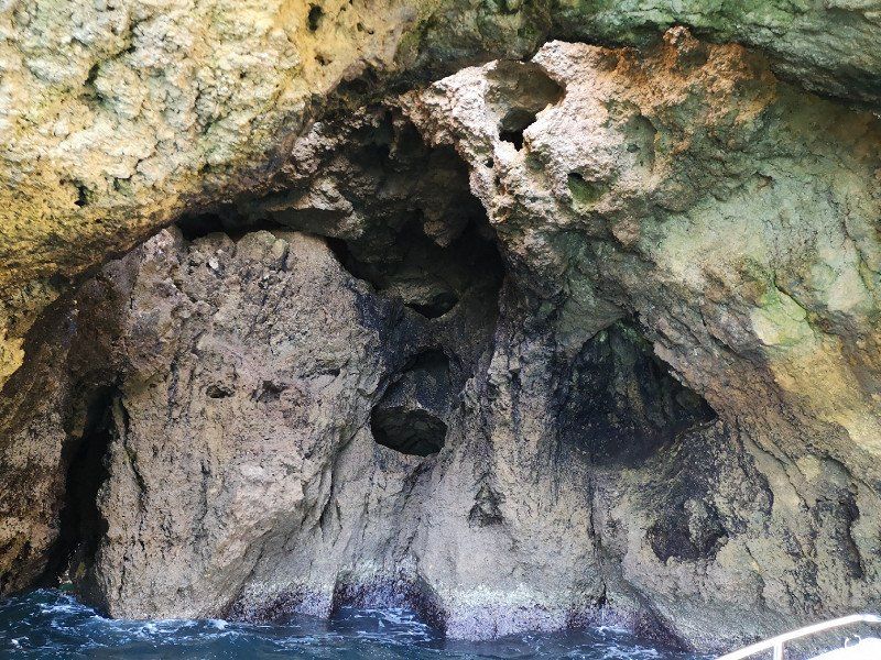
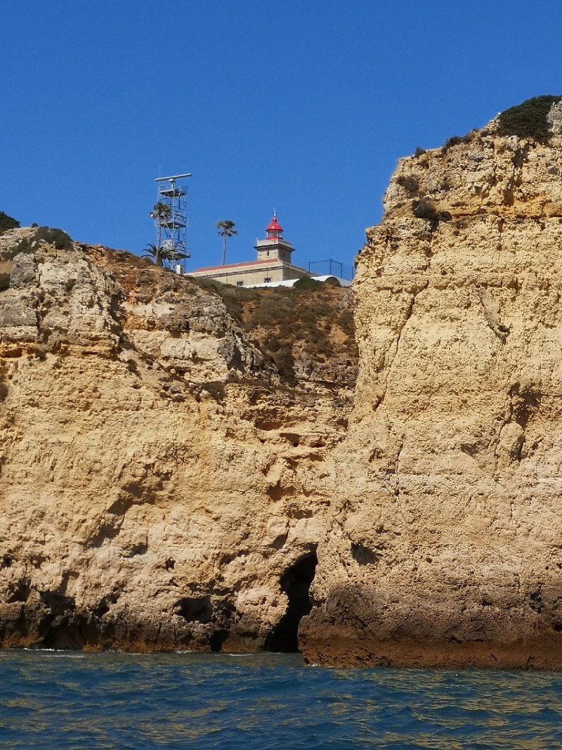
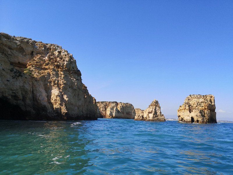
A boat tour to the Ponta da Piedade is definitely a little adventure and affordable for €20.
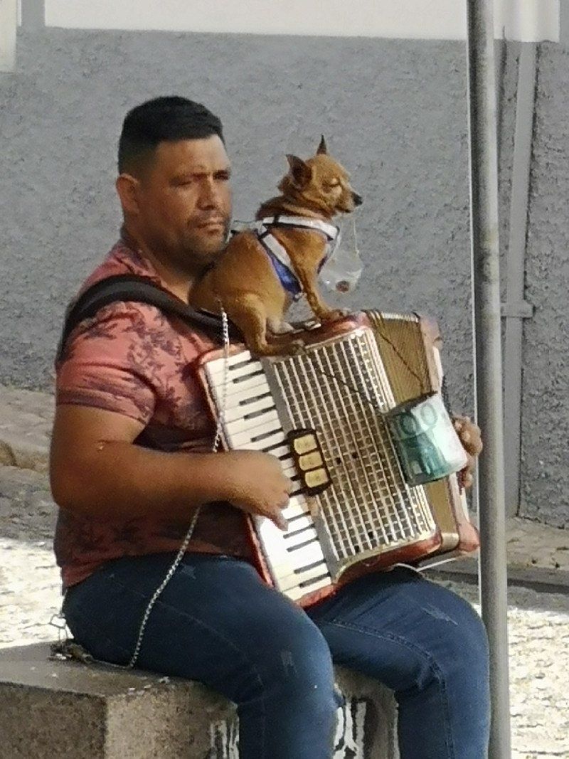
In the old town at Praca de Gil Eanes there are very good musicians almost every day. Here it is worth taking a break and simply relaxing
Portugal
37° 6' 10" N 8° 40' 22.9" W
37.1027881 -8.6730275
• Head east on Rua Dr. António José de Almeida.
• Turn slightly left onto Rua Doutor Faria e Silva. Go for 171 m.
• Turn right onto Rua Conselheiro Joaquim Machado. Go for 145 m.
• Turn right onto Rua António Crisógono dos Santos. Go for 8 m.
• Turn right onto Rua da Capelinha. Go for 142 m.
• Turn right onto Avenida dos Descobrimentos (N125). Go for 134 m.
• Make a U-Turn onto Avenida dos Descobrimentos (N125). Go for 889 m.
• Take the 2nd exit from roundabout onto Avenida dos Descobrimentos (N125) toward Portimão/Faro/Lisboa/Aljezur/Bensafrim. Go for 352 m.
• Take the 2nd exit from roundabout onto Avenida da Fonte Coberta toward Luz/Sagres/A22. Go for 852 m.
• Take the 2nd exit from roundabout toward V. do Bispo/A22. Go for 650 m.
• Continue toward V. do Bispo/N125/Sagres. Go for 48 m.
• Take the 2nd exit from roundabout toward V. do Bispo/Sagres. Go for 914 m.
• Continue toward V. do Bispo/Sagres. Go for 42 m.
• Take the 2nd exit from roundabout onto N125 toward V. do Bispo/Sagres/Vila do Bispo. Go for 2.8 km.
• Pass 4 roundabouts and continue on N125. Go for 7.2 km.
• Take the 3rd exit from roundabout onto N125 toward V. do Bispo/Sagres. Go for 1.6 km.
• Pass 4 roundabouts and continue on N125. Go for 8.7 km.
• Continue on N268. Go for 7.3 km.
• Continue on Avenida Infante Dom Henrique (N268). Go for 1.4 km.
• Take the 3rd exit from roundabout onto Rua de São Vicente. Go for 343 m.
• Turn right onto Praça da República. Go for 99 m.
• Turn left onto Rua da Fortaleza. Go for 347 m.
• Turn right. Go for 28 m.
• Turn slightly right. Go for 17 m.
• Turn slightly right. Go for 71 m.
• Arrive at your destination.
☍
34,3 km
( 38 min.)
Day
Área Ponta de Sagres
At the end of the world in Sagres
From the west coast, the first stop in the Algarve is Sagres, the most south-western point on the Cabo de São Vicente. Roaring sea, mighty cliffs and extensive beaches are waiting for you here. No wonder people used to think this was the end of the world. In Sagres there is also a beautiful lighthouse, a fort and many national parks. In addition, there is the legendary sausage stand "The Last Bratwurst Before America", which of course you shouldn't miss either. Our insider tip: Definitely try the dough rolls filled with Nutella, they taste heavenly.
Rua infante Dom Henrique, 8650-317, Sagres, Portugal
37° 0' 19" N 8° 56' 42" W
37.0052778 -8.9450000
• Head northwest. Go for 103 m.
• Turn right toward Avenida Infante Dom Henrique/N268. Go for 198 m.
• Take the 2nd exit from roundabout onto Avenida Infante Dom Henrique (N268). Go for 1.5 km.
• Continue on N268. Go for 7.3 km.
• Turn right toward N268/Aljezur/V. do Bispo. Go for 470 m.
• Turn right onto N268. Go for 27.4 km.
• Turn left onto N120. Go for 7.5 km.
• Take the 2nd exit from roundabout onto N120 toward Lisboa/Odeceixe/Rogil/Lagos/Bordeira. Go for 15.3 km.
• Turn sharp left onto Variante 19 de Abril. Go for 647 m.
• Turn left onto Rua da Várzea. Go for 137 m.
• Arrive at Rua da Várzea. Your destination is on the right.
☍
60,6 km
(1 hrs. )
Odeceixe
According to the guide book, should be a very nice picturesque village....
Portugal
37° 25' 58.2" N 8° 46' 17.8" W
37.4328321 -8.7716242
• Head east on Rua da Várzea.
• Continue on Rua do Gabão. Go for 96 m.
• Turn left onto Rua das Amoreiras. Go for 20 m.
• Turn right onto Rua do Forno. Go for 36 m.
• Turn left onto Rua das Amoreiras. Go for 108 m.
• Turn right toward Variante 19 de Abril. Go for 13 m.
• Turn right onto Variante 19 de Abril. Go for 560 m.
• Turn left onto N120. Go for 11.6 km.
• Take the 2nd exit from roundabout onto N120 toward Odemira. Go for 1.2 km.
• Take the 3rd exit from roundabout onto M502-1 toward Casa Branca. Go for 4.3 km.
• Turn right onto M502. Go for 8.3 km.
• Turn left onto N393. Go for 5.9 km.
• Take the 1st exit from roundabout onto N393 toward Cercal/V. N.va Milfontes. Go for 8.9 km.
• Take the 1st exit from roundabout onto N390 toward Cercal. Go for 867 m.
• Take the 2nd exit from roundabout onto N390 toward Cercal. Go for 1.6 km.
• Take the 3rd exit from roundabout onto M1072 toward Porto Covo. Go for 1.6 km.
• Continue on Malhadinhas (M1072). Go for 119 m.
• Continue on M1072. Go for 109 m.
• Continue on Malhadinhas (M1072). Go for 165 m.
• Continue on M1072. Go for 792 m.
• Turn left. Go for 2.3 km.
• Continue straight ahead. Go for 411 m.
• Arrive at your destination.
☍
48,9 km
( 51 min.)
Day
Vila Nova de Milfontes, Portugal
Q5PX+H7Q Vila Nova de Milfontes, Portugal
37° 47' 11.2" N 8° 48' 6.4" W
37.7864534 -8.8017654
• Head southwest. Go for 1.1 km.
• Turn left toward M1072. Go for 1.1 km.
• Turn left onto M1072. Go for 8.4 km.
• Turn right onto M554-1. Go for 822 m.
• Turn right onto M1116. Go for 20 m.
• Turn left. Go for 445 m.
• Arrive at your destination on the right.
☍
11,9 km
( 24 min.)
Porto Covo
Portugal
37° 51' 11.8" N 8° 45' 32.9" W
37.8532797 -8.7591311
• Head west. Go for 445 m.
• Turn sharp left onto M1116. Go for 2.4 km.
• Turn left onto Rua 1 de Maio. Go for 3.9 km.
• Continue on Largo da Liberdade. Go for 54 m.
• Continue on Rua 25 de Abril. Go for 8.7 km.
• Turn right onto M553. Go for 2.5 km.
• Turn slightly left onto N390. Go for 8.4 km.
• Turn right onto N261. Go for 13.6 km.
• Turn left onto N261. Go for 664 m.
• Take the 2nd exit from roundabout onto N261. Go for 1.0 km.
• Turn left onto IC1 toward Lisboa/Grândola. Go for 7.4 km.
• Turn right onto N121 toward Beja/Ferreira/Canhestros. Go for 8.4 km.
• Take the 2nd exit from roundabout onto Rua 1 de Fevereiro (N121). Go for 15.5 km.
• Take the 3rd exit from roundabout onto N2. Go for 774 m.
• Take the 3rd exit from roundabout onto N2. Go for 402 m.
• Pass 2 roundabouts and continue on N2. Go for 12.4 km.
• Take the 1st exit from roundabout onto N2. Go for 1.2 km.
• Turn right onto N257. Go for 18.3 km.
• Continue on Adro. Go for 95 m.
• Continue on Largo da Igreja. Go for 38 m.
• Continue on Rua das Igrejas. Go for 26 m.
• Continue on Avenida dos Bombeiros Voluntários (N257). Go for 9.5 km.
• Turn left onto Rua do Lagar Novo (N257). Go for 104 m.
• Turn right onto Largo dos Guisentos (N257). Go for 493 m.
• Take the 1st exit from roundabout onto R254. Go for 282 m.
• Pass 4 roundabouts and continue on R254. Go for 27.1 km.
• Take the 3rd exit from roundabout onto IP2 toward Évora. Go for 701 m.
• Pass 2 roundabouts and continue on IP2. Go for 1.5 km.
• Take the 2nd exit from roundabout onto Rua Serpa Pinto toward Centro Rossio/Giraldo. Go for 99 m.
• Continue on Avenida da Gulbenkian. Go for 327 m.
• Turn right onto Rua da República. Go for 413 m.
• Continue on Praça do Giraldo. Go for 122 m.
• Continue on Rua Serpa Pinto. Go for 71 m.
• Turn right onto Rua dos Caldeireiros. Go for 47 m.
• Continue on Rua de Santa Catarina. Go for 99 m.
• Turn left onto Rua Gabriel Victor Pereira Monte. Go for 125 m.
• Continue on Rua de São Cristóvão. Go for 186 m.
• Continue on Largo Penedos. Go for 25 m.
• Turn left onto Rua da Cal Branca. Go for 69 m.
• Arrive at Rua da Cal Branca. Your destination is on the right.
☍
147,4 km
(2 hrs. 3 min.)
Day
Évora, Portugal
38° 34' 17.2" N 7° 54' 48.6" W
38.5714310 -7.9135020
• Head toward Rua Carta Velha on Rua da Cal Branca. Go for 83 m.
• Turn left onto Rua São Domingos. Go for 21 m.
• Turn left onto Rua Frei Bráz. Go for 148 m.
• Continue on Largo Penedos. Go for 24 m.
• Turn left onto Rua dos Penedos. Go for 93 m.
• Continue on Largo das Alterações de Évora. Go for 30 m.
• Turn right onto Rua Serpa Pinto. Go for 44 m.
• Turn left onto Avenida de Lisboa toward Beja/Alcáçovas/Horta das Figueiras/Rossio/Giraldo. Go for 320 m.
• Take the 1st exit from roundabout onto Avenida Túlio Espanca (N114) toward A6/Lisboa/Montemor/Malagueira. Go for 301 m.
• Take the 2nd exit from roundabout onto Avenida Túlio Espanca (N114). Go for 333 m.
• Take the 2nd exit from roundabout onto Avenida Túlio Espanca (N114) toward A6/Lisboa/Montemor. Go for 197 m.
• Pass 2 roundabouts and continue on N114. Go for 10.1 km.
• Take ramp onto A6 (Autoestrada do Alentejo Central) toward Lisboa. Go for 59.8 km.
• Continue on IP7 (Nó da A2-A6-A13). Go for 892 m.
• Continue on A2 (Autoestrada do Sul). Go for 52.1 km.
• Continue on IP7 (Ponte 25 de Abril). Go for 4.4 km.
• Take the exit toward Cascais/Sintra/IC19/Monsanto/Estoril onto A5 (Autoestrada da Costa do Estoril). Go for 3.2 km.
• Take exit 3 toward Sintra/IC19/Amadora onto N117. Go for 909 m.
• Take ramp onto Estrada da Circunvalação toward Aeroporto/Norte/A1. Go for 1.3 km.
• Arrive at Estrada da Circunvalação. Your destination is on the left.
☍
134,3 km
(1 hrs. 21 min.)
Day
Day
Lissabon
Lisboa Camping & Bungalows, simple but clean, is located in a natural forest. A taxi to the city costs about 10-12€.
Tuktuk are very common; we got a 1-hour ride for 60€ instead of 90€ in the off-season, unfortunately only superficially... I can't recommend it. It is better to book a free tour of the city by locals based on tips with a free tour (e.g. Guruwalk). It was very interesting and we will be happy to book again in the future.
Estrada da Circunvalação, 1400 - 061, Monsanto, Portugal
38° 43' 28.4" N 9° 12' 28.8" W
38.7245600 -9.2080000
• Head south on Estrada da Circunvalação.
• Turn left. Go for 18 m.
• Make a U-Turn. Go for 101 m.
• Turn right onto Estrada da Circunvalação. Go for 142 m.
• Turn left onto Estrada de Almarjão. Go for 84 m.
• Take the 1st exit from roundabout onto Estrada de Almarjão. Go for 440 m.
• Take the 3rd exit from roundabout onto Estrada de Almarjão toward Amadora/Sintra. Go for 178 m.
• Take ramp onto N117 toward Amadora/Sintra. Go for 2.9 km.
• Take ramp onto Autoestrada Radial de Sintra (A37) toward Sintra/Hospital. Go for 7.0 km.
• Keep left onto Autoestrada Radial de Sintra (A37) toward Sintra/Cacém Poente. Go for 1.2 km.
• Keep left onto Autoestrada Radial de Sintra (A37) toward Sintra/Rio de Mouro. Go for 2.5 km.
• Keep left onto Autoestrada Radial de Sintra (A37) toward Sintra/Mem Martins/Carcavelos/N249-4. Go for 2.4 km.
• Take ramp onto A16 toward Sintra/Mafra/Ericeira/Pêro Pinheiro. Go for 3.0 km.
• Take exit 8 toward Centro Sintra/Colares onto Avenida General Mário Firmino Miguel. Go for 381 m.
• Keep left onto Avenida General Mário Firmino Miguel toward Colares/Sintra. Go for 799 m.
• Take the 2nd exit from Rotunda Doutor Eduardo Lacerda Tavares roundabout onto Avenida Doutor Desidério Cambournac toward Colares/Lourel/Estefânea Norte/Portela. Go for 556 m.
• Take the 2nd exit from roundabout onto Avenida Doutor Desidério Cambournac toward Colares/Estefânea-Norte. Go for 360 m.
• Continue on Avenida Heliodoro Salgado (N9). Go for 34 m.
• Arrive at Avenida Heliodoro Salgado (N9).
☍
22,1 km
( 19 min.)
Day
Sintra
Palacios Nacional da Pena, an incredibly beautiful castle that should not be missing on any trip to Portugal.
In the Sintra area there is almost no campsite and no shady or electrically powered pitches that are suitable for dog owners. By chance we came across the Parking Bus Sintra, which is quite safe, has tree shade and is close to the Palacios Nacional da Pena. With the app bolt, a pick-up on site as well as a cheap journey by "taxi" (approx. 4€ per trip) is possible... This also applies to the return trip.
In order to avoid long waiting times, it is essential to buy an entry ticket online beforehand. I would not recommend a shuttle ticket (only a short walk) or audio (there is only one app for the mobile phone).
Portugal
38° 48' 10.3" N 9° 22' 54" W
38.8028687 -9.3816589
• Head toward Rua Cp. Mário Alberto Soares Pimentel on Avenida Heliodoro Salgado (N9). Go for 82 m.
• Take the 4th exit from roundabout onto Avenida Heliodoro Salgado (N9). Go for 205 m.
• Continue on Avenida Doutor Desidério Cambournac. Go for 311 m.
• Take the 2nd exit from roundabout onto Avenida Doutor Desidério Cambournac. Go for 565 m.
• Take the 1st exit from Rotunda Doutor Eduardo Lacerda Tavares roundabout onto Avenida General Mário Firmino Miguel toward A16/A9/IC19/Algueirão. Go for 892 m.
• Take ramp onto A16 toward Lisboa/Mafra/Norte/A9. Go for 11.8 km.
• Take the left exit toward CREL/Norte/Lisboa/IC16 onto A9 (CREL). Go for 13.6 km.
• Take exit 5 toward Leiria onto A8 (Autoestrada do Oeste). Go for 66.0 km.
• Take exit 15 toward Óbidos/Peniche. Go for 923 m.
• Take the 2nd exit from roundabout onto N8 toward Peniche. Go for 735 m.
• Take the 1st exit from roundabout onto Rua da Memória. Go for 66 m.
• Turn right onto Rua da Porta da Vila. Go for 194 m.
• Turn slightly left onto Rua Direita. Go for 152 m.
• Turn left onto Travessa de Baltasar Figueira. Go for 17 m.
• Turn left onto Rua Facho. Go for 21 m.
• Arrive at Rua Facho. Your destination is on the right.
☍
95,5 km
( 57 min.)
Day
Óbidos
See book 1000 sights.... Intact walkable city wall. Nice stopover.
RV park at the aquaduct for 6 €
Portugal
39° 21' 37.5" N 9° 9' 29.5" W
39.3604212 -9.1582014
• Head north on Rua Facho. Go for 21 m.
• Turn right onto Travessa de Baltasar Figueira. Go for 17 m.
• Turn left onto Rua Direita. Go for 269 m.
• Continue on Largo São Tiago. Go for 30 m.
• Turn slightly left onto Largo São Tiago. Go for 70 m.
• Turn slightly left onto Largo São Tiago. Go for 228 m.
• Turn slightly right onto Estrada da Cerca. Go for 379 m.
• Turn sharp left onto Estrada da Cerca. Go for 321 m.
• Turn sharp right onto Rua Estação. Go for 541 m.
• Turn left onto N8. Go for 1.9 km.
• Take the 2nd exit from roundabout onto N8. Go for 515 m.
• Take ramp onto A8 (Autoestrada do Oeste) toward Leiria/Alcobaça. Go for 28.3 km.
• Take exit 22 toward Nazaré. Go for 978 m.
• Take the 2nd exit from roundabout onto N8-5 toward Tomar/Nazaré. Go for 667 m.
• Take the 3rd exit from roundabout onto N8-5 toward Nazaré. Go for 228 m.
• Take the 2nd exit from roundabout onto Avenida da Nazaré (N8-5). Go for 1.9 km.
• Continue on N8-5. Go for 1.9 km.
• Pass 2 roundabouts and continue on N8-5. Go for 450 m.
• Take the 1st exit from roundabout onto N8-5 toward Nazaré. Go for 391 m.
• Continue on Rua Combatentes do Ultramar (N8-5). Go for 391 m.
• Take the 1st exit from Rotunda do Matadouro roundabout onto Avenida Nogent-Sur Marne (N242). Go for 252 m.
• Take the 4th exit from Rotunda da Cerâmica roundabout onto Avenida Circular Norte. Go for 198 m.
• Turn left onto Avenida Circular Norte. Go for 40 m.
• Turn slightly right onto Avenida da Independência Nacional. Go for 30 m.
• Continue on Avenida de Olivença. Go for 90 m.
• Continue on Rua Adrião Batalha. Go for 143 m.
• Turn left onto Rua Mouzinho de Albuquerque. Go for 14 m.
• Turn right onto Rua França Borges. Go for 25 m.
• Arrive at Rua França Borges. Your destination is on the left.
☍
40,3 km
( 33 min.)
Nazaré, Portugal
Surer paradise with monster waves.... Only because of that we made a short stop, but it was nothing, the monster waves are there in October/November
2450 Nazaré, Portugal
39° 36' 4.4" N 9° 4' 12.4" W
39.6012147 -9.0700991
• Head toward Travessa do Açougue on Rua França Borges. Go for 37 m.
• Turn slightly left onto Travessa do Açougue. Go for 4 m.
• Turn left onto Travessa do Açougue. Go for 17 m.
• Turn left onto Rua Joaquim Bernardo de Souza Lobo. Go for 68 m.
• Turn right onto Rua Mouzinho de Albuquerque. Go for 83 m.
• Keep left onto Rua Mouzinho de Albuquerque. Go for 139 m.
• Turn left onto Avenida dos Bombeiros Voluntários (N242). Go for 151 m.
• Take the 2nd exit from Rotunda do Matadouro roundabout onto Rua Combatentes do Ultramar (N8-5). Go for 422 m.
• Continue on N8-5. Go for 370 m.
• Take the 3rd exit from roundabout onto N8-5 toward Lisboa/Leiria/Valado dos Frades. Go for 194 m.
• Pass 2 roundabouts and continue on N8-5. Go for 2.2 km.
• Continue on Avenida da Nazaré (N8-5). Go for 1.8 km.
• Take the 2nd exit from roundabout onto N8-5. Go for 237 m.
• Take the 2nd exit from roundabout onto N8-5 toward Alcobaça/A8. Go for 660 m.
• Take the 3rd exit from roundabout onto A8 (Autoestrada do Oeste) toward Leiria. Go for 20.6 km.
• Take the exit toward Leiria Sul/A1/N242/M.nha Grande onto A8 (Nó da A8-A17). Go for 12.6 km.
• Take exit 29 toward Lisboa/Porto/A1 onto A8-1. Go for 2.5 km.
• Take ramp onto A1 (Autoestrada do Norte) toward Lisboa/Fátima. Go for 15.0 km.
• Take exit 8 toward N356/Fátima/(IC9)/Batalha. Go for 1.5 km.
• Take ramp onto Avenida João XXIII (N356) toward Rotunda Sul/Ourém/Tomar. Go for 1.9 km.
• Take the 2nd exit from Rotunda dos Pastorinhos roundabout onto Avenida Irmã Lúcia de Jesus (N356) toward Ourém/Tomar. Go for 1.4 km.
• Continue on Avenida Irmã Lúcia de Jesus. Go for 160 m.
• Arrive at Avenida Irmã Lúcia de Jesus. Your destination is on the right.
☍
62,2 km
( 43 min.)
Day
Fátima
place of pilgrimage
Portugal
39° 37' 1" N 8° 39' 7.3" W
39.6169407 -8.6520361
• Head toward Rua da Cooperativa on Avenida Irmã Lúcia de Jesus. Go for 7 m.
• Turn left onto Estrada Nossa Senhora da Ortiga. Go for 1.6 km.
• Take the 2nd exit from roundabout onto Estrada Nossa Senhora da Ortiga. Go for 874 m.
• Keep left onto Estrada do Vale do Porto. Go for 1.5 km.
• Continue on Estrada da Nossa Senhora da Ortiga. Go for 910 m.
• Continue on Estrada de Ourém. Go for 193 m.
• Turn right onto Estrada do Vale. Go for 2.2 km.
• Turn slightly left onto Rua Principal. Go for 643 m.
• Continue on Avenida Pedro Pais Faria Caupers. Go for 363 m.
• Continue on Rua Luís de Camões. Go for 625 m.
• Continue on Rua Padre Manuel Bento Moreira. Go for 87 m.
• Turn right onto N349. Go for 2.2 km.
• Turn left onto Rua da Saudade. Go for 917 m.
• Continue on Estrada dos Toucinhos. Go for 2.2 km.
• Take the 3rd exit from roundabout onto IC9 toward Tomar. Go for 9.2 km.
• Take ramp toward Tomar Oeste/Carregueiros. Go for 460 m.
• Take the 2nd exit from roundabout onto N113. Go for 3.0 km.
• Take the 2nd exit from roundabout onto Avenida Marquês de Tomar. Go for 355 m.
• Continue on Rua de João Carlos Everard. Go for 210 m.
• Take the 3rd exit from Praça Alves Redol roundabout onto Ponte Eng. Eduardo de Arantes Oliveira. Go for 189 m.
• Continue on Avenida Norton de Matos. Go for 92 m.
• Take the 2nd exit from roundabout onto Avenida Norton de Matos. Go for 271 m.
• Continue on Avenida Ângela Tamagnini. Go for 113 m.
• Take the 1st exit from roundabout onto Praça Raúl Lopes. Go for 87 m.
• Turn left onto Praça Raúl Lopes. Go for 69 m.
• Turn right onto Rua Lopo Dias Sousa. Go for 216 m.
• Take the 1st exit from roundabout onto Estrada do Barreiro. Go for 104 m.
• Turn right. Go for 88 m.
• Turn left. Go for 14 m.
• Arrive at your destination on the right.
☍
28,9 km
( 29 min.)
Tomar
Convention do Christo
Portugal
39° 36' 19.4" N 8° 24' 15.5" W
39.6053819 -8.4043125
• Head northeast. Go for 14 m.
• Turn right toward Estrada do Barreiro. Go for 88 m.
• Turn left onto Estrada do Barreiro. Go for 89 m.
• Take the 3rd exit from roundabout onto Rua Lopo Dias Sousa. Go for 237 m.
• Continue on Praça Raúl Lopes. Go for 78 m.
• Take the 2nd exit from roundabout onto Alameda 1 de Março. Go for 230 m.
• Turn slightly right onto Rua Marquês de Pombal. Go for 137 m.
• Continue on Ponte Velha. Go for 94 m.
• Turn right onto Avenida Marquês de Tomar. Go for 332 m.
• Take the 2nd exit from roundabout onto Largo do Pelourinho (N113). Go for 2.9 km.
• Take the 2nd exit from roundabout toward Coimbra/Entronc.to/Tomar Norte. Go for 118 m.
• Take ramp onto IC9. Go for 37.0 km.
• Take ramp toward Batalha/Reg.go Fetal/Alq.dão Serra. Go for 751 m.
• Take the 2nd exit from roundabout onto Estrada de Fátima (N356) toward Batalha. Go for 2.2 km.
• Pass 2 roundabouts and continue on Estrada de Fátima (N356). Go for 1.0 km.
• Take the 1st exit from roundabout onto Estrada de Fátima. Go for 272 m.
• Continue on Rua António Maria dos Santos. Go for 30 m.
• Enter the roundabout. Go for 42 m.
• Arrive at your destination on the left.
☍
45,6 km
( 34 min.)
Batalha
Mosteiro da Batalha
Portugal
39° 39' 29.9" N 8° 49' 26.8" W
39.6582957 -8.8241243
• Follow the roundabout. Go for 50 m.
• Take the 3rd exit from roundabout onto Rua António Maria dos Santos toward A8. Go for 30 m.
• Continue on Estrada de Fátima. Go for 241 m.
• Take the 2nd exit from roundabout onto IC2 toward Lisboa/A8/Porto/Nazaré. Go for 1.5 km.
• Take the 3rd exit from roundabout onto N356. Go for 1.1 km.
• Take the 1st exit from roundabout onto Estrada Real Dona Maria I. Go for 302 m.
• Take the 2nd exit from roundabout onto A19 (Autoestrada Variante da Batalha) toward Leiria. Go for 7.2 km.
• Take exit 4 toward Aveiro/A17/Fig.ra Foz/Lisboa/M.nha Grande. Go for 576 m.
• Take the exit toward A17/Lisboa/M.nha Grande onto A8 (Autoestrada do Oeste). Go for 5.0 km.
• Take exit 24A toward Aveiro/Figueira da Foz onto A17 (Autoestrada do Litoral Centro). Go for 109 km.
• Take exit 16 toward Aveiro Sul. Go for 278 m.
• Take the 3rd exit from roundabout onto N235 toward Aveiro Sul. Go for 6.6 km.
• Continue on Avenida da Universidade. Go for 784 m.
• Take the 2nd exit from roundabout onto Avenida da Universidade. Go for 598 m.
• Take the 3rd exit from Rotunda do Hospital roundabout onto Rua de Calouste Gulbenkian. Go for 418 m.
• Take the 2nd exit from roundabout onto Rua Condessa Mumadona Dias. Go for 492 m.
• Take the 1st exit from Rotunda dos Marnotos roundabout onto Rua do Alavário. Go for 231 m.
• Continue on Rua do Clube dos Galitos. Go for 131 m.
• Turn right onto Rua Belém do Pará. Go for 134 m.
• Arrive at Rua Belém do Pará. Your destination is on the left.
☍
134,9 km
(1 hrs. 30 min.)
Day
Day
Day
Camping Praia da Costa Nova
The fishing village with the colorful cute houses
Portugal
40° 38' 25.8" N 8° 39' 13.5" W
40.6405055 -8.6537539
• Head toward Praça da República on Rua Belém do Pará. Go for 42 m.
• Continue on Rua Gustavo Ferreira Pinto Bastos. Go for 103 m.
• Turn right onto Rua Professor Barbosa de Magalhães. Go for 84 m.
• Turn left onto Rua do Capitão João Souza Pizarro. Go for 222 m.
• Turn right onto Avenida Artur Ravara. Go for 255 m.
• Take the 1st exit from Rotunda do Hospital roundabout onto Rua de Calouste Gulbenkian. Go for 377 m.
• Take the 2nd exit from roundabout onto Rua Condessa Mumadona Dias. Go for 492 m.
• Take the 3rd exit from Rotunda dos Marnotos roundabout onto A25 (Autoestrada Beiras Litoral e Alta) toward V. Formoso/Viseu/Lisboa/Porto. Go for 6.1 km.
• Take the left exit toward Viseu/Porto/A29 onto A25 (Autoestrada da Costa da Prata). Go for 10.1 km.
• Take exit 7 toward Porto onto A1 (Autoestrada do Norte). Go for 28.2 km.
• Take exit 18 toward Ovar. Go for 1.0 km.
• Take the 3rd exit from roundabout onto N223 toward Hospital/Porto/Coimbra. Go for 3.6 km.
• Pass 4 roundabouts and continue on N223. Go for 2.2 km.
• Take left ramp toward A32/Porto/Gaia. Go for 182 m.
• Take the 2nd exit from roundabout onto N223 toward Gaia. Go for 1.2 km.
• Take the 3rd exit from roundabout toward Pigeiros/Gaia/Ol. Azemeis. Go for 2.0 km.
• Take the 2nd exit from roundabout. Go for 7.2 km.
• Take the 2nd exit from roundabout. Go for 134 m.
• Turn right onto N326. Go for 17.8 km.
• Take the 3rd exit from roundabout onto Rua Eça de Queiroz. Go for 161 m.
• Take the 1st exit from roundabout. Go for 103 m.
• Continue on Rua Eça de Queiroz. Go for 43 m.
• Continue on Rua Dom Afonso Henriques (N326). Go for 70 m.
• Take the 1st exit from roundabout onto Avenida 25 de Abril (N326). Go for 273 m.
• Turn left onto Praça Brandão de Vasconcelos. Go for 35 m.
• Turn slightly right onto Rua Dr. Coelho da Rocha. Go for 22 m.
• Arrive at Rua Dr. Coelho da Rocha. Your destination is on the left.
☍
82,1 km
(1 hrs. 4 min.)
Day
Arouca Geopark, Rua Alfredo Vaz Pinto, Arouca, Portugal, Portugal
THE LONGEST SUSPENSION BRIDGE IN THE WORLD IS IN PORTUGAL
The longest pedestrian suspension bridge in the world has opened in Portugal. The 516 meter long structure spans the valley of the Rio Pavia river near the town of Arouca.
The huge structure is 516 meters long and is therefore referred to as 516 Arouca. The colossus hangs 175 meters above the river and is therefore not exactly something for people with a fear of heights! But if you manage to overcome the height, you get something in return: a fantastic view of the valley of the Rio Pavia, which is located in the UNESCO Geopark Arouca.
It is best to park the mobile home in the parking lot at the starting point Areinho. From there to the bridge it is about 30-45 minutes with a somewhat strenuous climb up the stairs. Buy the ticket for the bridge online in advance (at least 1 day in advance) and pay attention to the time window, so there is no waiting time. Bridge ticket also includes trail fee.
The control point for the bridge and trailer is just below the bridge. The start from Areinho is the less strenuous one as it follows the river downhill.
R. Alfredo Vaz Pinto, 4540-118 Arouca, Portugal
40° 55' 45" N 8° 14' 44.7" W
40.9291537 -8.2457371
• Head north on Rua Dr. Coelho da Rocha. Go for 17 m.
• Turn right onto Rua 1 de Maio. Go for 30 m.
• Turn right onto Rua 1 de Maio. Go for 55 m.
• Turn right onto Avenida 25 de Abril (N326). Go for 295 m.
• Take the 3rd exit from roundabout onto Rua Dom Afonso Henriques (N326). Go for 109 m.
• Continue on Rua Eça de Queiroz. Go for 125 m.
• Take the 2nd exit from roundabout. Go for 144 m.
• Continue on Rua Eça de Queiroz. Go for 13 m.
• Take the 2nd exit from roundabout onto N326. Go for 17.8 km.
• Turn left. Go for 67 m.
• Take the 2nd exit from roundabout. Go for 7.2 km.
• Take the 1st exit from roundabout onto A32 (Autoestrada de Entre Douro-e-Vouga) toward Gaia. Go for 22.5 km.
• Take exit 8 toward Porto/(Freixo)/Gaia onto A20 (CRIP). Go for 531 m.
• Take exit 2 toward Espinho/Canelas/Hospital onto A29 (Nó do Freixo IP1). Go for 1.6 km.
• Take exit 16 toward Porto/(Arrábida)/Gaia onto A1 (Autoestrada do Norte). Go for 8.5 km.
• Take the exit toward Hospital/C.po Alegre onto Via Panorâmica Edgar Cardoso. Go for 890 m.
• Turn right onto Rua do Campo Alegre toward Baixa Centro. Go for 464 m.
• Turn right toward Boavista/Faculdade Direito. Go for 38 m.
• Turn left toward Praça da Galiza. Go for 80 m.
• Turn left onto Rua de Júlio Dinis toward Boavista. Go for 574 m.
• Enter the roundabout. Go for 167 m.
• Arrive at Praça Mouzinho de Albuquerque.
☍
61,2 km
( 49 min.)
Day
Day
Porto, Portugal
41° 9' 28.6" N 8° 37' 44.8" W
41.1579438 -8.6291053
• Follow the roundabout. Go for 94 m.
• Take the 1st exit from roundabout onto Avenida de França. Go for 532 m.
• Turn right onto Rua da Quinta Amarela. Go for 221 m.
• Turn left onto Rua de Oliveira Monteiro. Go for 254 m.
• Continue on Praça do Exército Libertador. Go for 157 m.
• Continue on Rua do Carvalhido. Go for 157 m.
• Turn right onto Rua de Sousa Pinto toward Lisboa/A1/Braga/A3/VCI/P.te Freixo/Aeroporto. Go for 230 m.
• Turn left onto Rua de Acácio Lino toward Lisboa/A1/Braga/A3/VCI/Ponte do Freixo/Aeroporto. Go for 148 m.
• Take the 1st exit from Rotunda Orlando Ribeiro roundabout toward Braga/A3/Vila Real/A4/P.te Freixo/IC23/Lisboa/A1/Aeroporto. Go for 150 m.
• Take ramp onto A20 (CRIP) toward P.te Freixo/Lisboa/A1/Braga/A3/V. Real/A4. Go for 2.2 km.
• Take the exit toward Valença/Braga/Vila Real/A4/Valongo onto A3 (Autoestrada do Minho). Go for 77.1 km.
• Take exit 11 toward N203/P.te Lima. Go for 499 m.
• Take the 1st exit from roundabout onto N203 toward V.na Castelo/Pt.e Lima. Go for 607 m.
• Take the 1st exit from roundabout onto N203. Go for 1.8 km.
• Take the 1st exit from roundabout onto Avenida António Feijó. Go for 85 m.
• Take the 2nd exit from roundabout onto Avenida António Feijó. Go for 211 m.
• Turn left onto Rua Conselheiro António Ferreira. Go for 190 m.
• Turn right onto Praceta Doutor Vieira de Araújo. Go for 24 m.
• Arrive at Praceta Doutor Vieira de Araújo. Your destination is on the left.
☍
84,7 km
( 57 min.)
Day
Ponte de Lima
Portugal
41° 45' 53" N 8° 34' 57.9" W
41.7647333 -8.5827407
• Head toward Praceta Fernão de Magalhães on Praceta Doutor Vieira de Araújo. Go for 24 m.
• Turn left onto Rua Conselheiro António Ferreira. Go for 184 m.
• Turn right onto Avenida António Feijó. Go for 179 m.
• Take the 1st exit from roundabout onto Avenida António Feijó. Go for 122 m.
• Take the 3rd exit from roundabout onto Via do Foral Velho de D. Teresa (N203). Go for 1.9 km.
• Turn right toward N203. Go for 24 m.
• Take the 2nd exit from roundabout onto N203 toward Espanha/Valença/A3. Go for 675 m.
• Take the 2nd exit from roundabout onto A3 (Autoestrada do Minho) toward Valença/Espanha. Go for 35.2 km.
• Continue on A-55. Go for 4.5 km.
• Take exit 26B toward Pontevedra/Vigo onto AP-9 (Autoestrada do Atlántico). Go for 110 km.
• Take exit 67 toward Centro Cidade Santiago/Lugo/Aeroporto Lavacolla (SCQ)/Santiago Norte/Centro Histórico onto SC-20 (Avenida de Camilo José Cela). Go for 2.1 km.
• Take ramp toward Aeroporto Lavacolla/Lugo/Oviedo/Meixonfrío. Go for 246 m.
• Take the 3rd exit from roundabout onto Avenida de Asturias toward Santiago de Compostela/Avda. Asturias/Meixonfrío. Go for 1.6 km.
• Take the 3rd exit from Estrada Mallou de Arriba roundabout onto Avenida do Cruceiro da Coruña. Go for 1.1 km.
• Continue on Rúa de San Caetano. Go for 322 m.
• Continue on Avenida de Xoán XXIII. Go for 720 m.
• Continue on Avenida de Xoán XXIII. Go for 420 m.
• Continue on Rúa Costa de San Francisco. Go for 45 m.
• Turn left onto Rúa de San Francisco. Go for 225 m.
• Turn slightly right onto Rúa de San Francisco. Go for 50 m.
• Turn slightly left onto Praza do Obradoiro. Go for 52 m.
• Continue on Rúa do Franco. Go for 37 m.
• Continue on Rúa Fonseca. Go for 64 m.
• Turn slightly right onto Praza das Praterías. Go for 17 m.
• Turn left onto Praza das Praterías. Go for 25 m.
• Turn right onto Rúa Conga. Go for 113 m.
• Turn left onto Rúa Conga. Go for 30 m.
• Turn left onto Rúa San Paio de Antealtares. Go for 136 m.
• Turn right onto Vía Sacra. Go for 29 m.
• Turn left onto Rúa da Acibechería. Go for 72 m.
• Continue on Praza da Inmaculada. Go for 27 m.
• Arrive at Praza da Inmaculada. Your destination is on the left.
☍
160,3 km
(1 hrs. 41 min.)
Day
Santiago de Compostela
Praza do Obradoiro, s/n, 15704 Santiago de Compostela, A Coruña, Spanien
42° 52' 50.1" N 8° 32' 40.7" W
42.8805962 -8.5446412
• Head toward Rúa de San Francisco on Praza da Inmaculada. Go for 17 m.
• Turn slightly left onto Travesa das Dúas Portas. Go for 109 m.
• Turn left onto Rúa de San Francisco. Go for 84 m.
• Turn slightly right onto Rúa de San Francisco. Go for 50 m.
• Turn slightly left onto Praza do Obradoiro. Go for 52 m.
• Continue on Rúa do Franco. Go for 37 m.
• Continue on Rúa Fonseca. Go for 42 m.
• Turn right onto Rúa da Raíña. Go for 114 m.
• Turn right onto Travesa do Franco. Go for 29 m.
• Turn right onto Rúa do Franco. Go for 17 m.
• Turn left onto Travesía Fonseca. Go for 78 m.
• Turn left onto Avenida de Rodrigo de Padrón. Go for 102 m.
• Continue on Avenida de Figueroa. Go for 80 m.
• Turn left onto Avenida de Figueroa. Go for 26 m.
• Turn right onto Avenida de Xoán Carlos I. Go for 271 m.
• Continue on Avenida de Rosalía de Castro. Go for 483 m.
• Take the 3rd exit from roundabout onto Avenida Romero Donallo. Go for 533 m.
• Turn sharp right onto Avenida de Antonio Fraguas. Go for 3.1 km.
• Take ramp toward E-1/AP-9/Pontevedra/A Coruña/Noia. Go for 359 m.
• Take left ramp onto AG-56 toward Noia. Go for 11.8 km.
• Continue on Gundín (CG-1.5). Go for 17.3 km.
• Take ramp toward Noia Norte. Go for 841 m.
• Take the 3rd exit from roundabout onto Orro (AC-550) toward P.I. Augalevada/Noia Norte. Go for 297 m.
• Continue on AC-550. Go for 269 m.
• Continue on Estrada Orro (AC-550). Go for 544 m.
• Continue on AC-550. Go for 168 m.
• Continue on Rúa Vista Fermosa (AC-550). Go for 450 m.
• Take the 2nd exit from roundabout onto Rúa Vista Fermosa (AC-550). Go for 856 m.
• Continue on Rúa Carcasia (AC-550). Go for 273 m.
• Continue on Rúa Calvario (AC-550). Go for 145 m.
• Continue on Rúa Rosalía de Castro (AC-550). Go for 32 m.
• Take the 1st exit from roundabout onto Rúa Rosalía de Castro (AC-550). Go for 49 m.
• Turn right onto Rúa da Pedra Sartaña. Go for 208 m.
• Continue on Peirao do Marqués. Go for 294 m.
• Turn left onto Costa do Ferrador (AC-550). Go for 142 m.
• Turn left onto Rúa Rosalía de Castro (AC-550). Go for 11 m.
• Arrive at Rúa Rosalía de Castro (AC-550). Your destination is on the right.
☍
39,3 km
( 36 min.)
Day
Noia
Great coastal road
Spanien
42° 47' 3.4" N 8° 53' 17.8" W
42.7842757 -8.8882891
• Head toward Rúa Galicia on Rúa Rosalía de Castro (AC-550). Go for 258 m.
• Take the 2nd exit from roundabout onto Rúa Rosalía de Castro (AC-550). Go for 55 m.
• Continue on Rúa Calvario (AC-550). Go for 145 m.
• Continue on Rúa Carcasia (AC-550). Go for 273 m.
• Continue on Rúa Vista Fermosa (AC-550). Go for 821 m.
• Take the 2nd exit from roundabout onto Rúa Vista Fermosa (AC-550). Go for 476 m.
• Continue on AC-550. Go for 168 m.
• Continue on Estrada Orro (AC-550). Go for 544 m.
• Continue on AC-550. Go for 269 m.
• Continue on Orro (AC-550). Go for 206 m.
• Take the 2nd exit from roundabout onto AC-550 toward Outes/Muros. Go for 1.4 km.
• Keep left onto AC-554 toward Muros. Go for 4.1 km.
• Take the 2nd exit from roundabout onto Catasueiro (AC-550). Go for 18.3 km.
• Take the 2nd exit from Rúa Acea roundabout onto Avenida Buenos Aires (AC-550). Go for 1.5 km.
• Arrive at Avenida Calvo Sotelo (AC-550). Your destination is on the right.
☍
28,5 km
( 32 min.)
Muros
Great coastal road
Spanien
42° 46' 28.6" N 9° 3' 28.3" W
42.7746007 -9.0578552
• Head southeast on Avenida Calvo Sotelo (AC-550). Go for 40.6 km.
• Turn right onto Avenida Fisterra (AC-552). Go for 1.7 km.
• Take the 2nd exit from roundabout onto O Vilar de Toba (AC-552). Go for 610 m.
• Take the 3rd exit from roundabout onto VG-1.4. Go for 5.0 km.
• Take the 1st exit from roundabout onto Rúa da Coruña (AC-445). Go for 1.2 km.
• Continue on AC-445. Go for 196 m.
• Continue on Sardiñeiro de Abaixo (AC-445). Go for 50 m.
• Continue on AC-445. Go for 17 m.
• Continue on Sardiñeiro de Abaixo (AC-445). Go for 211 m.
• Continue on AC-445. Go for 2.0 km.
• Continue on Calcova (AC-445). Go for 222 m.
• Continue on AC-445. Go for 120 m.
• Continue on Calcova (AC-445). Go for 308 m.
• Continue on AC-445. Go for 53 m.
• Continue on Calcova (AC-445). Go for 38 m.
• Continue on As Escaselas (AC-445). Go for 830 m.
• Continue on Lugar Anchoa (AC-445). Go for 780 m.
• Continue on AC-445. Go for 743 m.
• Turn right onto Rúa Cabo Fisterra (AC-445). Go for 155 m.
• Continue on Rúa Alcalde Fernández (AC-445). Go for 201 m.
• Arrive at Rúa Alcalde Fernández (AC-445). Your destination is on the right.
☍
55,0 km
( 55 min.)
Faro de Fisterra
destination of the Way of Saint James
Spanien
42° 54' 28.1" N 9° 15' 54.1" W
42.9078005 -9.2650315
• Head toward Camiño da Barcia on Rúa Alcalde Fernández (AC-445). Go for 145 m.
• Turn left toward Rúa Federico Ávila. Go for 13 m.
• Turn left toward Rúa Federico Ávila. Go for 18 m.
• Turn right onto Rúa Alcalde Fernández (AC-445). Go for 331 m.
• Continue on Rúa Cabo Fisterra (AC-445). Go for 155 m.
• Turn left onto AC-445. Go for 743 m.
• Continue on Lugar Anchoa (AC-445). Go for 780 m.
• Continue on As Escaselas (AC-445). Go for 830 m.
• Continue on Calcova (AC-445). Go for 38 m.
• Keep right onto AC-445. Go for 53 m.
• Continue on Calcova (AC-445). Go for 308 m.
• Continue on AC-445. Go for 120 m.
• Continue on Calcova (AC-445). Go for 222 m.
• Continue on AC-445. Go for 2.0 km.
• Continue on Sardiñeiro de Abaixo (AC-445). Go for 211 m.
• Continue on AC-445. Go for 17 m.
• Continue on Sardiñeiro de Abaixo (AC-445). Go for 50 m.
• Continue on AC-445. Go for 196 m.
• Continue on Rúa da Coruña (AC-445). Go for 1.2 km.
• Take the 2nd exit from roundabout onto VG-1.4. Go for 4.9 km.
• Take the 2nd exit from roundabout onto Cavado (AC-552). Go for 1.1 km.
• Turn left onto Morancelle (CP-2803). Go for 374 m.
• Continue on CP-2803. Go for 41 m.
• Continue on Morancelle (CP-2803). Go for 7 m.
• Continue on San Xián (CP-2803). Go for 518 m.
• Continue on Rúa San Xian (CP-2803). Go for 199 m.
• Continue on San Xián (CP-2803). Go for 84 m.
• Continue on Bermún (CP-2803). Go for 81 m.
• Continue on Bermún (CP-2303). Go for 381 m.
• Continue on CP-2303. Go for 504 m.
• Continue on Sinagoga (CP-2303). Go for 88 m.
• Continue on CP-2303. Go for 266 m.
• Continue on Sinagoga (CP-2303). Go for 467 m.
• Continue on Mintiráns (CP-2303). Go for 167 m.
• Continue on CP-2303. Go for 28 m.
• Continue on Mintiráns (CP-2303). Go for 507 m.
• Continue on CP-2303. Go for 437 m.
• Continue on Caberta (CP-2303). Go for 350 m.
• Continue on CP-2303. Go for 106 m.
• Continue on Caberta (CP-2303). Go for 29 m.
• Continue on CP-2303. Go for 1.0 km.
• Continue on Sorna (CP-2303). Go for 305 m.
• Keep right onto Lugar Sorna (CP-2303). Go for 193 m.
• Continue on CP-2303. Go for 49 m.
• Continue on Sorna (CP-2303). Go for 63 m.
• Continue on CP-2303. Go for 145 m.
• Continue on Sorna (CP-2303). Go for 216 m.
• Continue on Vilarmide (CP-2303). Go for 284 m.
• Continue on CP-2303. Go for 65 m.
• Continue on Vilarmide (CP-2303). Go for 26 m.
• Continue on CP-2303. Go for 8 m.
• Continue on Vilarmide (CP-2303). Go for 96 m.
• Continue on A Aveeira (CP-2303). Go for 96 m.
• Continue on CP-2303. Go for 57 m.
• Continue on A Aveeira (CP-2303). Go for 147 m.
• Continue on Os Pasantes (CP-2303). Go for 535 m.
• Continue on Morpeguite (CP-2303). Go for 406 m.
• Continue on CP-2303. Go for 101 m.
• Continue on Morpeguite (CP-2303). Go for 105 m.
• Continue on CP-2303. Go for 459 m.
• Continue on Añobres (CP-2303). Go for 235 m.
• Continue on CP-2303. Go for 486 m.
• Continue on O Vilariño (CP-2303). Go for 462 m.
• Continue on CP-2303. Go for 406 m.
• Continue on Cartel (CP-2303). Go for 170 m.
• Continue on CP-2303. Go for 36 m.
• Continue on Alberguería (CP-2303). Go for 239 m.
• Continue on CP-2303. Go for 111 m.
• Continue on Alberguería (CP-2303). Go for 307 m.
• Continue on Estrada Muíños (CP-2303). Go for 17 m.
• Turn slightly left onto Alberguería (CP-2303). Go for 14 m.
• Continue on CP-2303. Go for 441 m.
• Continue on Moraime (CP-2303). Go for 289 m.
• Continue on Moraime (AC-440). Go for 141 m.
• Continue on AC-440. Go for 60 m.
• Continue on Moraime (AC-440). Go for 76 m.
• Continue on AC-440. Go for 119 m.
• Continue on Moraime (AC-440). Go for 334 m.
• Continue on AC-440. Go for 187 m.
• Continue on As Casas Novas (AC-440). Go for 25 m.
• Continue on Chorente (AC-440). Go for 29 m.
• Continue on AC-440. Go for 129 m.
• Continue on Figueiras de Arriba (AC-440). Go for 347 m.
• Continue on AC-440. Go for 5 m.
• Continue on Figueiras de Arriba (AC-440). Go for 113 m.
• Continue on AC-440. Go for 17 m.
• Continue on Figueiras de Arriba (AC-440). Go for 119 m.
• Continue on AC-440. Go for 121 m.
• Continue on Figueiras de Arriba (AC-440). Go for 160 m.
• Continue on A Baiuca (AC-440). Go for 403 m.
• Continue on AC-440. Go for 321 m.
• Continue on A Baiuca (AC-440). Go for 20 m.
• Continue on AC-440. Go for 56 m.
• Continue on Avenida López Abente (AC-440). Go for 144 m.
• Continue on Rúa Mariña (AC-440). Go for 253 m.
• Turn left onto Rúa Real. Go for 43 m.
• Turn right onto Rúa Real. Go for 22 m.
• Turn left onto Rúa Eduardo Pondal. Go for 14 m.
• Continue on Rúa José María del Río. Go for 46 m.
• Turn slightly left onto Rúa Areal. Go for 7 m.
• Continue on Rúa Recuncho das Palilleiras. Go for 62 m.
• Take the 4th exit from roundabout onto Rúa Coido. Go for 132 m.
• Turn left onto Rúa Ramón Caamaño. Go for 29 m.
• Turn left onto Rúa Ramón Caamaño. Go for 41 m.
• Arrive at Rúa Ramón Caamaño. Your destination is on the right.
☍
29,2 km
( 32 min.)
Day
Muxía
Not worth visiting
Spanien
43° 6' 15.1" N 9° 13' 5.8" W
43.1041888 -9.2182913
• Head toward Rúa Recuncho das Palilleiras on Rúa Ramón Caamaño. Go for 53 m.
• Turn right onto Rúa Recuncho das Palilleiras. Go for 49 m.
• Continue on Rúa Areal. Go for 7 m.
• Turn slightly right onto Rúa José María del Río. Go for 46 m.
• Continue on Rúa Eduardo Pondal. Go for 14 m.
• Turn right onto Rúa Real. Go for 164 m.
• Continue on Avenida López Abente. Go for 269 m.
• Continue on AC-440. Go for 56 m.
• Continue on A Baiuca (AC-440). Go for 20 m.
• Continue on AC-440. Go for 321 m.
• Continue on A Baiuca (AC-440). Go for 403 m.
• Continue on Figueiras de Arriba (AC-440). Go for 160 m.
• Continue on AC-440. Go for 121 m.
• Continue on Figueiras de Arriba (AC-440). Go for 119 m.
• Continue on AC-440. Go for 17 m.
• Continue on Figueiras de Arriba (AC-440). Go for 113 m.
• Continue on AC-440. Go for 5 m.
• Continue on Figueiras de Arriba (AC-440). Go for 347 m.
• Continue on AC-440. Go for 129 m.
• Continue on Chorente (AC-440). Go for 29 m.
• Continue on As Casas Novas (AC-440). Go for 25 m.
• Continue on AC-440. Go for 187 m.
• Continue on Moraime (AC-440). Go for 334 m.
• Continue on AC-440. Go for 119 m.
• Continue on Moraime (AC-440). Go for 76 m.
• Continue on AC-440. Go for 60 m.
• Continue on Moraime (AC-440). Go for 141 m.
• Continue on AC-440. Go for 238 m.
• Continue on Moraime (AC-440). Go for 137 m.
• Continue on Os Muíños (AC-440). Go for 345 m.
• Continue on AC-440. Go for 10 m.
• Continue on Os Muíños (AC-440). Go for 44 m.
• Continue on Rúa Muíños (AC-440). Go for 154 m.
• Continue on Os Muíños (AC-440). Go for 142 m.
• Continue on Labexo (AC-440). Go for 317 m.
• Continue on AC-440. Go for 26 m.
• Continue on Labexo (AC-440). Go for 114 m.
• Continue on AC-440. Go for 566 m.
• Continue on A Casa do Monte-Moraime (AC-440). Go for 104 m.
• Continue on Vilar de Sobremonte (AC-440). Go for 690 m.
• Continue on San Martiño (AC-440). Go for 254 m.
• Continue on AC-440. Go for 466 m.
• Continue on Ozón (AC-440). Go for 384 m.
• Continue on Rúa Quintans (AC-440). Go for 785 m.
• Continue on AC-440. Go for 173 m.
• Continue on Quintáns (AC-440). Go for 141 m.
• Continue on AC-440. Go for 6.3 km.
• Turn left onto AC-552. Go for 14.4 km.
• Take the 3rd exit from roundabout onto Vía Alta C. Carballo-Berdoias (VG-1.5) toward A Coruña. Go for 2.2 km.
• Continue on AG-55 (Autovía da Costa da Morte). Go for 58.9 km.
• Keep right onto Estrada Baños de Arteixo (AG-55) toward avda. Finisterre/Avda. Alfonso Molina. Go for 296 m.
• Turn right onto Avenida Enrique Salgado Torres toward Alfonso Molina. Go for 374 m.
• Keep left onto Avenida de San Cristóbal toward AC-10/Hospital/AC-11/AP-9/Avenida Alfonso Molina. Go for 705 m.
• Take ramp onto Avenida Alcalde Alfonso Molina (AC-11) toward Aeroporto/Madrid/Ferrol/A-9/Santiago/Tui/N-550. Go for 1.5 km.
• Keep right onto AP-9 (Autopista del Atlántico) toward Santiago/Ferrol/E-70/A-6/Lugo. Go for 11.1 km.
• Take the left exit toward Guisamo/N-6/Ferrol onto AP-9 (Autoestrada do Atlántico). Go for 31.5 km.
• Take exit 31F toward Fene/Neda. Go for 176 m.
• Turn left onto AC-115. Go for 2.2 km.
• Turn right onto Lugar Portazgo (AC-862). Go for 6.2 km.
• Turn slightly left onto Vista Alegre (AC-862). Go for 3.6 km.
• Take the 2nd exit from roundabout onto AC-862. Go for 11.9 km.
• Turn right toward AC-862. Go for 255 m.
• Turn right onto AC-862. Go for 1.2 km.
• Turn left onto AC-862. Go for 1.2 km.
• Continue on Lugar Felgosas (AC-862). Go for 2.7 km.
• Keep right onto AC-862. Go for 186 m.
• Turn right toward AC-862. Go for 191 m.
• Continue on AC-862. Go for 7.7 km.
• Turn left onto CP-6121. Go for 113 m.
• Continue on A Ponte de Mera (CP-6121). Go for 796 m.
• Continue on Veiga (CP-6121). Go for 323 m.
• Continue on CP-6121. Go for 45 m.
• Continue on Veiga (CP-6121). Go for 792 m.
• Continue on CP-6121. Go for 273 m.
• Continue on Esteiro de Abaixo (CP-6121). Go for 386 m.
• Continue on Rúa Nova (CP-6121). Go for 9 m.
• Continue on Esteiro de Arriba (CP-6121). Go for 212 m.
• Continue on Rúa de Abaixo (CP-6121). Go for 93 m.
• Continue on A Adega (CP-6121). Go for 345 m.
• Continue on O Barral (CP-6121). Go for 236 m.
• Continue on Condomiña (CP-6121). Go for 299 m.
• Continue on CP-6121. Go for 991 m.
• Continue on Cabanán de Arriba (CP-6121). Go for 118 m.
• Continue on A Lama-Sismundi (CP-6121). Go for 15 m.
• Continue on CP-6121. Go for 286 m.
• Continue on A Lama-Sismundi (CP-6121). Go for 152 m.
• Continue on O Souto Chao (CP-6121). Go for 339 m.
• Continue on O Pazo (CP-6121). Go for 105 m.
• Continue on O Areado (CP-6121). Go for 217 m.
• Continue on O Carballo (CP-6121). Go for 80 m.
• Continue on Vimbieiro (CP-6121). Go for 474 m.
• Continue on CP-6121. Go for 81 m.
• Continue on Reboredo-Sismundi (CP-6121). Go for 492 m.
• Continue on CP-6121. Go for 104 m.
• Continue on A Ortigueira (CP-6121). Go for 153 m.
• Continue on CP-6121. Go for 27 m.
• Continue on A Ortigueira (CP-6121). Go for 289 m.
• Continue on A Basanta (CP-6121). Go for 118 m.
• Continue on A Castiñeira (CP-6121). Go for 181 m.
• Continue on A Cerca (CP-6121). Go for 459 m.
• Turn left onto Estrada a Cedeira (DP-2204). Go for 787 m.
• Continue on DP-2204. Go for 758 m.
• Continue on O Campo do Monte (DP-2204). Go for 1.3 km.
• Continue on O Castro (DP-2204). Go for 191 m.
• Continue on DP-2204. Go for 375 m.
• Continue on O Castro (DP-2204). Go for 89 m.
• Turn left onto As Maciñeiras (DP-2204). Go for 146 m.
• Continue on O Castro (DP-2204). Go for 77 m.
• Continue on DP-2204. Go for 1.0 km.
• Turn left toward O Castro. Go for 361 m.
• Continue on O Castro. Go for 122 m.
• Continue on A Golpa. Go for 127 m.
• Arrive at A Golpa. Your destination is on the right.
☍
187,4 km
(2 hrs. 21 min.)
Mirador de Vixia de Herbeira
Very nice view from the highest cliffs in Europe
Spanien
43° 43' 39.7" N 7° 54' 52.6" W
43.7277059 -7.9146038
• Head north on A Golpa. Go for 127 m.
• Continue on O Castro. Go for 483 m.
• Turn right onto DP-2204. Go for 1.0 km.
• Continue on O Castro (DP-2204). Go for 77 m.
• Continue on As Maciñeiras (DP-2204). Go for 146 m.
• Turn right onto O Castro (DP-2204). Go for 89 m.
• Continue on DP-2204. Go for 375 m.
• Continue on O Castro (DP-2204). Go for 191 m.
• Continue on O Campo do Monte (DP-2204). Go for 1.3 km.
• Continue on DP-2204. Go for 758 m.
• Continue on Estrada a Cedeira (DP-2204). Go for 787 m.
• Turn right onto Estrada a Mera (CP-6121). Go for 459 m.
• Continue on A Castiñeira (CP-6121). Go for 181 m.
• Continue on A Basanta (CP-6121). Go for 118 m.
• Continue on A Ortigueira (CP-6121). Go for 289 m.
• Continue on CP-6121. Go for 27 m.
• Continue on A Ortigueira (CP-6121). Go for 153 m.
• Continue on CP-6121. Go for 104 m.
• Continue on Reboredo-Sismundi (CP-6121). Go for 492 m.
• Continue on CP-6121. Go for 81 m.
• Continue on Vimbieiro (CP-6121). Go for 474 m.
• Continue on O Carballo (CP-6121). Go for 80 m.
• Continue on O Areado (CP-6121). Go for 217 m.
• Continue on O Pazo (CP-6121). Go for 105 m.
• Continue on O Souto Chao (CP-6121). Go for 339 m.
• Continue on A Lama-Sismundi (CP-6121). Go for 152 m.
• Keep right onto CP-6121. Go for 286 m.
• Continue on A Lama-Sismundi (CP-6121). Go for 15 m.
• Continue on Cabanán de Arriba (CP-6121). Go for 118 m.
• Continue on CP-6121. Go for 991 m.
• Continue on Condomiña (CP-6121). Go for 299 m.
• Continue on O Barral (CP-6121). Go for 236 m.
• Continue on A Adega (CP-6121). Go for 345 m.
• Continue on Rúa de Abaixo (CP-6121). Go for 93 m.
• Continue on Esteiro de Arriba (CP-6121). Go for 212 m.
• Continue on Rúa Nova (CP-6121). Go for 9 m.
• Continue on Esteiro de Abaixo (CP-6121). Go for 386 m.
• Continue on CP-6121. Go for 273 m.
• Continue on Veiga (CP-6121). Go for 792 m.
• Continue on CP-6121. Go for 45 m.
• Continue on Veiga (CP-6121). Go for 323 m.
• Continue on A Ponte de Mera (CP-6121). Go for 796 m.
• Continue on CP-6121. Go for 113 m.
• Turn left onto A Ponte de Mera (AC-862). Go for 6.0 km.
• Take the 1st exit from roundabout onto Estrada de As Pontes de García Rodríguez (AC-101). Go for 767 m.
• Take the 2nd exit from roundabout onto Estrada de As Pontes de García Rodríguez (AC-101). Go for 375 m.
• Take the 3rd exit from roundabout onto CG-1.3. Go for 7.6 km.
• Take the 2nd exit from roundabout onto San Xoán toward Espasante/AC-862/Viveiro/LU-862/Estación de FEVE. Go for 235 m.
• Take the 2nd exit from roundabout onto AC-862. Go for 12.3 km.
• Continue on LU-862. Go for 13.5 km.
• Take the 2nd exit from roundabout onto LU-862. Go for 2.1 km.
• Take the 3rd exit from Estrada Viveiro roundabout onto LU-862. Go for 575 m.
• Turn left onto Avenida de Galicia (LU-862). Go for 244 m.
• Take the 2nd exit from roundabout onto Avenida Ramón Canosa (LU-862). Go for 4.4 km.
• Take the 2nd exit from roundabout onto Vía de Altas Prestacións Costa Norte (CG-2.3). Go for 7.9 km.
• Take the 2nd exit from roundabout onto Beltrán. Go for 433 m.
• Take the 2nd exit from roundabout onto Beltrán (LU-862). Go for 1.3 km.
• Turn left toward Avenida de Lieiro/N-642. Go for 38 m.
• Continue on O Castelo (N-642). Go for 167 m.
• Continue on Avenida de Lieiro (N-642). Go for 331 m.
• Continue on O Castelo (N-642). Go for 23 m.
• Continue on Lieiro (N-642). Go for 367 m.
• Continue on Lieiro (LU-P-1501). Go for 172 m.
• Continue on San Cibrao (LU-P-1501). Go for 27 m.
• Continue on Lieiro (LU-P-1501). Go for 39 m.
• Continue on San Cibrao (LU-P-1501). Go for 862 m.
• Continue on San Cibrao. Go for 83 m.
• Continue on Rúa Beiramar. Go for 73 m.
• Take the 1st exit from roundabout onto Rúa de Campos. Go for 86 m.
• Turn right onto Rúa Rosalía de Castro. Go for 83 m.
• Arrive at Rúa Rosalía de Castro.
☍
74,1 km
(1 hrs. 16 min.)
San Cibrao
Beautiful, free parking space right by the sea
Spanien
43° 41' 37.8" N 7° 26' 29.5" W
43.6938309 -7.4415158
• Head toward Rúa das Areas on Rúa Rosalía de Castro. Go for 155 m.
• Turn right onto Avenida da Veiga. Go for 112 m.
• Take the 2nd exit from roundabout onto Avenida Bellavista (LU-P-1501). Go for 600 m.
• Take the 2nd exit from roundabout onto San Cibrao (LU-P-1501). Go for 734 m.
• Continue on LU-P-1501. Go for 610 m.
• Take the 1st exit from roundabout onto LU-P-1501. Go for 301 m.
• Take the 2nd exit from roundabout onto Río Covo. Go for 94 m.
• Turn right onto Río Covo. Go for 1.2 km.
• Take the 2nd exit from roundabout onto Espiñeirido (N-642). Go for 10.1 km.
• Continue on Vilachá (N-642). Go for 5.9 km.
• Pass 3 roundabouts and continue on Vilaxuane (N-642). Go for 8.0 km.
• Take the 3rd exit from roundabout onto A Anea (N-634). Go for 8.5 km.
• Take the 3rd exit from roundabout onto Estrada LU-P-5206 toward Playa de as Catedrais. Go for 656 m.
• Take the 2nd exit from roundabout onto Estrada LU-P-5206. Go for 449 m.
• Turn right. Go for 101 m.
• Arrive at your destination.
☍
37,5 km
( 38 min.)
Day
Praia das Catedrais, Spanien
Visit at low tide, then you can explore the rocks on the beach.
As Catedrais beach, Spanien
43° 33' 14.6" N 7° 9' 26" W
43.5540577 -7.1572259
• Head southwest. Go for 97 m.
• Turn right toward Estrada LU-P-5206. Go for 12 m.
• Turn left onto Estrada LU-P-5206. Go for 388 m.
• Take the 1st exit from roundabout onto Estrada LU-P-5206. Go for 574 m.
• Take the 2nd exit from roundabout toward Oviedo/A Coruña. Go for 150 m.
• Take ramp onto A-8 (Autovía do Cantábrico) toward Ribadeo/Oviedo. Go for 15.6 km.
• Take exit 501 toward Barres-Castropol/Vegadeo/Lugo/Serantes-Tapia de C./Serantes/Tapia de Casariego/Avilés/Ribadeo/E-70/A Coruña/A-8. Go for 284 m.
• Take the 4th exit from roundabout onto N-634 toward E-70/A-8/Ribadeo/A Coruña/Avilés. Go for 311 m.
• Take the 1st exit from roundabout onto N-634 toward Serantes/Tapia de C./Avilés. Go for 369 m.
• Take the 1st exit from roundabout onto N-634. Go for 3.6 km.
• Turn right. Go for 32 m.
• Continue toward Avenida San Esteban. Go for 39 m.
• Continue toward Avenida General Primo de Rivera. Go for 555 m.
• Continue on Avenida General Primo de Rivera. Go for 423 m.
• Turn right onto Avenida San Esteban. Go for 124 m.
• Arrive at Avenida San Esteban. Your destination is on the left.
☍
22,5 km
( 18 min.)
Parking Playa Grande
Nice parking lot with sea view
Av. San Esteban, 33740, Tapia de Casariego, Spanien
43° 33' 59" N 6° 56' 45" W
43.5663889 -6.9458333
• Head southeast on Avenida San Esteban.
• Turn left onto Avenida San Esteban. Go for 47 m.
• Continue on Avenida Doctor José Luis Pérez Campoamor. Go for 143 m.
• Continue on Calle La Industrial. Go for 115 m.
• Turn right onto Calle Coronado Villar. Go for 339 m.
• Turn left toward N-634. Go for 566 m.
• Turn left onto N-634. Go for 1.1 km.
• Take the 1st exit from roundabout onto AS-23. Go for 374 m.
• Pass 2 roundabouts and continue on AS-23. Go for 1.8 km.
• Take the 2nd exit from roundabout onto A-8 (Autovía del Cantábrico) toward Luarca/Oviedo. Go for 78.0 km.
• Take exit 417 toward Carcedo/N-632/Aeropuerto. Go for 441 m.
• Take the 1st exit from roundabout. Go for 431 m.
• Take ramp onto N-632 toward Avilés. Go for 1.2 km.
• Turn left onto N-643 toward Aeropuerto. Go for 104 m.
• Continue on Carcedo (N-643). Go for 160 m.
• Continue on N-643. Go for 575 m.
• Turn right onto CT-1. Go for 396 m.
• Arrive at CT-1. Your destination is on the left.
☍
85,8 km
( 50 min.)
Day
Santiago del Monte
Very nice vantage point with incredible google road layout
Spanien
43° 33' 0.1" N 6° 1' 33.9" W
43.5500295 -6.0260701
• Head southwest on CT-1. Go for 396 m.
• Turn left onto N-643. Go for 575 m.
• Continue on Carcedo (N-643). Go for 160 m.
• Continue on N-643. Go for 87 m.
• Turn left onto N-632. Go for 2.8 km.
• Take the 2nd exit from roundabout onto A-8 (Autovía del Cantábrico) toward Oviedo/Gijón/Avilés/Aeropuerto. Go for 52.3 km.
• Take the left exit toward Villaviciosa/Santander onto A-8 (Autovía del Cantábrico). Go for 15.8 km.
• Take exit 346 toward Lastres/AS-257/Venta del Pobre. Go for 299 m.
• Take the 2nd exit from roundabout onto N-632 toward Colunga/Santander/Lastres/AS-257/Villaviciosa/E-70/Oviedo/A-8. Go for 264 m.
• Take the 2nd exit from roundabout onto AS-257 toward Lastres. Go for 5.6 km.
• Continue on Camino a La Venta del Pobre (AS-257). Go for 295 m.
• Continue on Calle Barrigón (AS-257). Go for 377 m.
• Arrive at Calle Barrigón (AS-257). Your destination is on the left.
☍
78,9 km
( 50 min.)
Llastres
Small fishing village where a Spanish medical series was filmed.
Spanien
43° 30' 50.1" N 5° 16' 14" W
43.5139204 -5.2705500
• Head toward Bajada del Puerto on Calle Barrigón (AS-257). Go for 37 m.
• Continue on Calle Cristo (AS-257). Go for 266 m.
• Continue on Calle San Antonio (AS-257). Go for 696 m.
• Continue on AS-257. Go for 2.0 km.
• Continue on Alameda Poladura (AS-257). Go for 789 m.
• Continue on Avenida Playa (AS-257). Go for 411 m.
• Take the 3rd exit from roundabout onto Avenida Generalísimo (N-632). Go for 53 m.
• Continue on Avenida Asturias (N-632). Go for 318 m.
• Continue on Avenida Generalísimo (N-632). Go for 298 m.
• Continue on N-632. Go for 494 m.
• Take the 1st exit from roundabout onto AS-260 toward Arriondas/Coceña/E-70/A-8. Go for 345 m.
• Take the 3rd exit from roundabout onto AS-260 toward Arriondas. Go for 137 m.
• Continue toward Autovía del Cantábrico/A-8. Go for 22 m.
• Take the 3rd exit from roundabout onto A-8 (Autovía del Cantábrico) toward Ribadesella/Santander. Go for 139 km.
• Take the exit onto A-8 (Autovía del Cantábrico). Go for 70.3 km.
• Keep left onto AP-8 toward Balmaseda/BI-636/Bilbao/Miribilla/Vitoria-Gasteiz/Donostia/S. Sebastián. Go for 14.9 km.
• Take the exit toward Donostia/San Sebastián/E-804/Vitoria-Gasteiz/AP-68 onto A-8 (Autovía del Cantábrico). Go for 1.6 km.
• Keep left onto AP-8 (Autopista del Cantábrico) toward A-8/Donostia-San Sebastián. Go for 86.4 km.
• Take the exit toward Hernani/Pasaia/Irun/Baiona/Bordeaux onto AP-1/AP-8 (Segundo Cinturón de San Sebastián). Go for 14.6 km.
• Take the exit onto AP-8. Go for 12.7 km.
• Continue on A63 (Autoroute de la Côte Basque). Go for 206 km.
• Take the exit toward Paris/Toulouse/Bordeaux/Talence onto A630 (Rocade de Bordeaux). Go for 9.2 km.
• Keep left onto Rocade de Bordeaux (N230) toward Paris/A10/Lyon/A89. Go for 8.4 km.
• Take ramp onto N89 toward Périgueux/Libourne/Yvrac. Go for 18.5 km.
• Keep left onto A89 toward Lyon/Périgueux/Bergerac/Libourne-Nord. Go for 167 km.
• Take the left exit toward Paris/Limoges/Lyon/A89/Clermont-Fd/Tulle/Brive-Est onto A20 (L'Occitane). Go for 16.7 km.
• Take exit 46.1 toward Lyon/Clermont-Fd/Tulle/St-Germain les V. onto A89. Go for 161 km.
• Take the left exit toward E11/Paris/Montluçon/Vichy onto A71. Go for 46.6 km.
• Take exit 11 toward E62/Moulins/Bourbon l'Arch. onto A79. Go for 45.5 km.
• Take exit 29 toward Montbeugny. Go for 462 m.
• Take the 1st exit from roundabout onto D53 toward Montbeugny. Go for 463 m.
• Turn left onto D105. Go for 2.5 km.
• Continue on Rue de la Dierne (D105). Go for 167 m.
• Turn right onto Rue de l'Agriculture (D12). Go for 272 m.
• Arrive at Rue de l'Agriculture (D12). Your destination is on the left.
☍
1,027,1 km
(9 hrs. 2 min.)
Day
Montbeugny
Overnight stay on the way home
Frankreich
46° 31' 43.2" N 3° 29' 20" E
46.5286600 3.4888820
• Head toward Chemin des Merlins on Rue de l'Agriculture (D12). Go for 272 m.
• Turn left onto Rue de la Dierne (D105). Go for 167 m.
• Continue on D105. Go for 2.5 km.
• Turn right onto D53. Go for 429 m.
• Take the 1st exit from roundabout onto A79 toward Chalon S/S./Mâcon/Montceau les M. Go for 45.9 km.
• Continue on N79. Go for 10.1 km.
• Continue on N70. Go for 43.7 km.
• Take the 2nd exit from Rond-Point Jeanne Rose roundabout onto N80 toward A6/Chalon S/S./A6/Chalon. Go for 26.6 km.
• Take the 1st exit from Giratoire de Cortelin roundabout onto Route Express Chalon Montceau (N80) toward Chalon S/Saône. Go for 450 m.
• Turn right toward A6/Paris/Dijon/Lyon/Bourg en B./Mâcon. Go for 332 m.
• Take ramp onto A6 (Autoroute du Soleil) toward Paris/Dijon. Go for 31.1 km.
• Continue on A31. Go for 5.3 km.
• Take the exit toward Mulhouse/Besançon/Dole onto A36 (La Comtoise). Go for 164 km.
• Keep left onto A36 (La Comtoise) toward Strasbourg/Mulhouse/Belfort/Montbéliard. Go for 74.2 km.
• Continue on A5/A36. Go for 87 m.
• Continue on A5. Go for 104 m.
• Take the left exit toward Karlsruhe/Stuttgart/Freiburg onto A5. Go for 35.4 km.
• Take exit 62 toward Donaueschingen/Freiburg onto B31A. Go for 5.0 km.
• Keep left onto Autobahnzubringer Mitte (B31A) toward Donaueschingen/Titisee-Neustadt/FR-Stadtmitte. Go for 25.8 km.
• Keep left onto B31 toward Villingen-Schwenningen/Donaueschingen/Titisee-Neustadt/B500. Go for 34.2 km.
• Turn right and take ramp onto B27/B33 toward Stuttgart/Villingen-Schwenningen/Bad Dürrheim/Donaueschingen. Go for 13.3 km.
• Keep right onto B27. Go for 16.3 km.
• Take the 2nd exit from roundabout toward Rottweil-Süd/Stadtmitte/Gewerbegebiet Saline/Süd. Go for 93 m.
• Continue on Tuttlinger Straße. Go for 356 m.
• Turn right onto Neufraer Straße. Go for 136 m.
• Take the 3rd exit from roundabout onto Römerstraße. Go for 1.5 km.
• Turn left onto Lehrstraße. Go for 523 m.
• Arrive at Lehrstraße. Your destination is on the left.
☍
537,6 km
(5 hrs. 8 min.)
Day
78628 Rottweil, Deutschland
48° 9' 48.4" N 8° 38' 48.6" E
48.1634481 8.6468210