Road trip from our home Lith via Sweden to the North Cape and back via Norway. We go through the bridges.
Day
Lith, Nederland
Molenstraat 1, 5397 EK Lith, Nederland
51° 48' 21.8" N 5° 26' 28" E
51.8060687 5.4411216
• Head toward Marktplein on Molenstraat. Go for 41 m.
• Turn right onto Marktplein (N625). Go for 3.6 km.
• Take the 2nd exit from roundabout onto Beatrixweg. Go for 2.6 km.
• Take the 2nd exit from roundabout onto Beatrixweg. Go for 1.5 km.
• Continue on Dorpenweg (N626). Go for 1.3 km.
• Pass 7 roundabouts and continue on Dorpenweg (N277). Go for 8.7 km.
• Turn right onto Erfsestraat toward Nijmegen/Herpen/Bedrijvenlocatie de Bulk. Go for 337 m.
• Turn right and take ramp onto A50 toward Nijmegen/Arnhem. Go for 11.2 km.
• Keep left onto A50. Go for 19.2 km.
• Take the exit toward Zwolle/Apeldoorn/Oberhausen/Arnhem onto A12/A50. Go for 6.5 km.
• Take the exit toward Apeldoorn/Zwolle onto A50. Go for 21.8 km.
• Take the exit toward Hengelo/Deventer onto A1. Go for 49.0 km.
• Take the exit toward Osnabrück/Enschede/Hengelo onto A1/A35. Go for 3.9 km.
• Continue on A1 toward Osnabrück/Hengelo/Borne. Go for 23.4 km.
• Continue on A30. Go for 64.0 km.
• Take exit 14 toward Bremen/Osnabrück-Hafen onto A1 (Hansalinie). Go for 202 km.
• Take exit 43 toward Flensburg/Kiel/Hamburg-West/Tötensen/Flughafen onto A261 (Buchholzer Dreieck). Go for 10.3 km.
• Continue on A7. Go for 11.6 km.
• Keep left onto A7. Go for 54.7 km.
• Take exit 16 toward Plön. Go for 390 m.
• Continue on Hamburger Chaussee (L319) toward Kiel/Neumünster/Plön/Brokenlande. Go for 8.2 km.
• Keep right onto Plöner Straße (K16) toward Plön. Go for 744 m.
• Turn right onto Sachsenring (L323). Go for 43 m.
• Arrive at Sachsenring (L323). Your destination is on the right.
☍
505,1 km
(4 hrs. 37 min.)
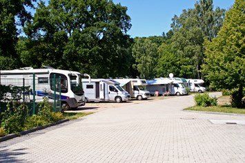
Neumünster, Duitsland
Wohnmobilstellplatz Bad am Stadtwald
Hansar ring 177
N54.08087 N54º4'51º
E 9.96110 E9º57'40"
site code:85573
€13.-- pn for 2 pers, electricity paid
Plöner Str. 84-86, 24534 Neumünster, Duitsland
54° 4' 11.4" N 9° 59' 56.4" E
54.0698359 9.9989918
• Head south on Sachsenring (L323). Go for 336 m.
• Make a U-Turn onto Sachsenring (L323). Go for 392 m.
• Continue on Feldstraße (B430) toward A7/Flensburg/Kiel/Rendsburg/Holstenhallen. Go for 1.7 km.
• Turn left onto Ilsahl (B430) toward Flensburg/A7/Rendsburg/Holstenhallen. Go for 1.6 km.
• Turn right onto Rendsburger Straße (L328). Go for 4.0 km.
• Take ramp onto A7 toward Flensburg/Kiel. Go for 90.4 km.
• Continue on E45 (Sønderjyske Motorvej). Go for 89.5 km.
• Keep right onto E20 (Kolding) toward Odense/Fredericia. Go for 84.6 km.
• Take exit 46 toward Nyborg V/Ørbæk/165. Go for 470 m.
• Turn left onto Hjulbyvej (8) toward Kerteminde/165/Nyborg C/160. Go for 1.0 km.
• Turn right onto Odensevej (160). Go for 874 m.
• Take the 2nd exit from roundabout onto Odensevej (160). Go for 3.1 km.
• Turn left onto Frisengårdsvej. Go for 993 m.
• Turn right onto Stentevej. Go for 156 m.
• Arrive at Stentevej. Your destination is on the left.
☍
279,1 km
(2 hrs. 36 min.)
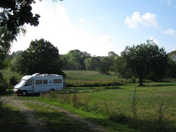
Nyborg, Denemarken
Sulkendrup Molle, Jan Grønbaek & Anette Lyholm
Sulkendrupvej 1
€13.50 pn for 2 persons
electricity paid
no wifi, tip: move the bathroom door upwards and then turn the button.
Nice place, can be a bit noisy.
Stentevej 13, 5800 Nyborg, Denemarken
55° 19' 24.7" N 10° 48' 1.3" E
55.3235366 10.8003480
• Head toward Karseløkken on Stentevej. Go for 156 m.
• Turn left onto Frisengårdsvej. Go for 993 m.
• Turn left onto Vestergade (160). Go for 774 m.
• Turn left onto Havnegade (163). Go for 392 m.
• Take the 2nd exit from roundabout onto Storebæltsvej (163). Go for 947 m.
• Turn right and take ramp onto E20 (Fynske Motorvej) toward København. Go for 110 km.
• Keep right onto Ishøj toward Ballerup/O4/21/København V. Go for 841 m.
• Continue on O4 (Ishøj). Go for 2.4 km.
• Take the exit toward København/21ø onto 21 (Holbækmotorvejen). Go for 10.2 km.
• Continue on Folehaven (O2) toward Centrum. Go for 1.3 km.
• Turn left onto Gammel Køge Landevej. Go for 1.3 km.
• Turn right onto Vigerslev Allé. Go for 1.4 km.
• Turn left onto Vesterfælledvej. Go for 835 m.
• Turn right onto Vesterbrogade. Go for 1.2 km.
• Turn left onto Stenosgade. Go for 148 m.
• Turn right onto Gammel Kongevej. Go for 138 m.
• Turn left onto Vester Søgade. Go for 29 m.
• Arrive at Vester Søgade. Your destination is on the left.
☍
133,2 km
(1 hrs. 25 min.)
København, Denemarken
Bellanhoj Camping
Hvidkildevej 66
site code 22414
€25.--pn for 2 pers.
electricity paid
large lawn, sanitary outdated. great location to visit Copenhagen from here.
City camping
discharge wastewater into a well at the Danish flag at the blue containers near camper field - bus [number 2A] to Copenhagen 100m - Copenhagen 4.5km - center 2km
Gl. Kongevej 10, 1610 København, Denemarken
55° 40' 28.7" N 12° 33' 29.3" E
55.6746378 12.5581518
• Head north on Vester Søgade. Go for 187 m.
• Turn right onto Herholdtsgade. Go for 177 m.
• Turn right onto Vester Farimagsgade. Go for 68 m.
• Turn left onto Ved Vesterport. Go for 91 m.
• Turn right onto Hammerichsgade. Go for 152 m.
• Continue on Bernstorffsgade. Go for 832 m.
• Turn right onto Kalvebod Brygge (O2) toward E20/21. Go for 2.6 km.
• Continue on Scandiagade toward Malmø/E20/Lufthavn/Odense/E47/Bella Center. Go for 372 m.
• Continue on Sydhavnsgade. Go for 510 m.
• Continue on Sjællandsbroen. Go for 832 m.
• Keep right onto Centrumforbindelsen toward Odense/E20/E47/E55/Malmø/Lufthavn. Go for 829 m.
• Take ramp onto E20 (Øresundsmotorvejen) toward Malmø/Lufthavn. Go for 19.5 km.
• Continue on E20 (Öresundsbron). Go for 14.6 km.
• Take exit 13 toward Lockarp/Industriområde Fosieby. Go for 419 m.
• Take the 1st exit from roundabout onto Arrievägen toward Lockarp. Go for 1.4 km.
• Take the 2nd exit from roundabout onto Sofiedalsvägen. Go for 2.1 km.
• Turn left onto Käglingevägen (101). Go for 1.2 km.
• Arrive at Käglingevägen (101). Your destination is on the left.
☍
46,0 km
( 36 min.)
Malmö, Zweden
The Malmöhus Castle
The bright red Malmöhus Castle is the oldest intact castle from the Swedish Renaissance . The castle is home to no fewer than four different museums.
The Turning Torso
The city's most talked-about building is the Turning Torso skyscraper, a 190-meter-high structure designed by Spanish architect Santiago Calatrava . The tower dominates the city and is visible from everywhere.
Lomma Camping & Resort
Södra Västkustvägen 114, 234 34 Lomma, Sweden, is located 12 km above Malmø
H328+JR Malmö, Zweden
55° 33' 5.6" N 13° 4' 1.4" E
55.5515569 13.0670694
• Head toward Kungshögsvägen on Käglingevägen (101). Go for 1.2 km.
• Turn right onto Lockarps Kyrkoväg toward Lockarp. Go for 2.0 km.
• Take the 1st exit from roundabout onto Arrievägen toward Malmö/Lockarp. Go for 1.5 km.
• Take the 3rd exit from roundabout onto E6/E20/E22 (Yttre Ringvägen) toward E65/Göteborg/Kalmar. Go for 13.2 km.
• Continue on E6/E20 toward E4/Göteborg/Stockholm. Go for 5.1 km.
• Take exit 20 toward Lomma onto 103. Go for 1.2 km.
• Continue toward Centrum. Go for 43 m.
• Take the 2nd exit from Prästbergarondellen roundabout toward Centrum. Go for 196 m.
• Continue on Tenngatan. Go for 377 m.
• Continue on Järngatan. Go for 854 m.
• Take the 1st exit from roundabout onto Södra Västkustvägen. Go for 1.5 km.
• Arrive at Södra Västkustvägen. Your destination is on the left.
☍
27,2 km
( 19 min.)
Lomma, Zweden
Lomma Camping & Resort
Södra Vastkustvagen 114, 234 34 Lomma, Sweden
Södra Västkustvägen 114, 234 34 Lomma, Zweden
55° 41' 24.7" N 13° 3' 35.7" E
55.6901962 13.0599246
• Head toward Fiskarhusvägen on Södra Västkustvägen. Go for 1.5 km.
• Take the 2nd exit from roundabout. Go for 553 m.
• Continue on Järngatan. Go for 410 m.
• Continue on Tenngatan. Go for 449 m.
• Take the 2nd exit from Prästbergarondellen roundabout toward E6/E20/Lund. Go for 267 m.
• Take ramp onto E6/E20 toward Malmö. Go for 19.7 km.
• Continue on E20 (Yttre Ringvägen) toward Flygplats/Köpenhamn/Limhamn. Go for 13.7 km.
• Continue on E20 (Øresundsbroen). Go for 26.7 km.
• Take the exit toward Helsingør/Sjællands Odde/21/København N-V onto E47 (Motorring 3). Go for 1.7 km.
• Take the exit toward Sjællands Odde/Roskilde onto 21 (Holbækmotorvejen). Go for 5.4 km.
• Take the exit toward Ballerup/Sj. Odde/Roskilde onto 21 (Vallensbæk). Go for 18.8 km.
• Continue on 21 (Holbækmotorvejen) toward Sjællands Odde. Go for 21.4 km.
• Keep right onto 23 toward Kalundborg. Go for 6.7 km.
• Take exit 2 toward Kvanløse/Holbæk/Sorø. Go for 298 m.
• Turn left onto Ringstedvej (57) toward Sorø/Ugerløse. Go for 8.3 km.
• Pass 2 roundabouts and continue on Hovedgaden (57). Go for 4.6 km.
• Turn right onto Stenmaglevej toward Assentorp. Go for 916 m.
• Turn right onto Engkrogen. Go for 602 m.
• Arrive at Engkrogen.
☍
131,9 km
(1 hrs. 24 min.)
HJ79+35 Stenlille, Denemarken
55° 33' 45.9" N 11° 37' 4.5" E
55.5627382 11.6179048
• Head toward Stenmaglevej on Engkrogen. Go for 602 m.
• Turn left onto Stenmaglevej. Go for 916 m.
• Turn left onto Sorøvej (57). Go for 4.0 km.
• Pass 2 roundabouts and continue on Holbæk Landevej (57). Go for 8.8 km.
• Turn right and take ramp onto 23 (Kalundborgmotorvejen) toward København. Go for 7.0 km.
• Continue on 21 (Holbæk). Go for 23.0 km.
• Continue on 21 (Holbækmotorvejen) toward København. Go for 15.9 km.
• Take the left exit toward København/E20ø/Lufthavn/E47n onto 21 (Holbækmotorvejen). Go for 5.5 km.
• Take the exit toward Lufthavn/E20/Malmø/København C onto E47 (Motorring 3). Go for 1.2 km.
• Take the left exit toward Lufthavn/Malmø/København C onto E20 (Amagermotorvejen). Go for 27.8 km.
• Continue on E20 (Öresundsbron). Go for 27.8 km.
• Take exit 18 toward Kalmar/Lund onto E22. Go for 45.0 km.
• Take ramp toward S Rörum/Hörby N. Go for 288 m.
• Turn left toward S Rörum. Go for 278 m.
• Continue on Fulltofta. Go for 2.2 km.
• Continue on Fulltofta. Go for 1.2 km.
• Continue on Fulltofta. Go for 2.7 km.
• Continue on Södra Rörum Hörbyvägen. Go for 429 m.
• Turn right onto Södra Rörum Häglingevägen. Go for 552 m.
• Continue on Södra Rörum. Go for 2.5 km.
• Continue on Fundersed. Go for 1.1 km.
• Continue on Fundersed. Go for 404 m.
• Continue on Fundersed. Go for 1.9 km.
• Continue on Stenshult. Go for 878 m.
• Continue on Häglinge. Go for 272 m.
• Continue on Västra Häglinge. Go for 221 m.
• Continue on Häglinge. Go for 623 m.
• Continue on Häglinge. Go for 79 m.
• Continue toward Häglinge. Go for 26 m.
• Continue on Häglinge. Go for 108 m.
• Continue on Häglinge. Go for 268 m.
• Continue on Västra Häglinge. Go for 260 m.
• Continue on Västra Häglinge. Go for 1.5 km.
• Continue on Röslöv. Go for 726 m.
• Continue on Fredriksberg. Go for 2.0 km.
• Turn left onto Sösdala toward Hässleholm. Go for 123 m.
• Take ramp onto 23 toward Hässleholm. Go for 18.7 km.
• Take the 2nd exit from roundabout onto 23 toward Växjö/119/Tingsryd. Go for 15.1 km.
• Turn right toward Glimminge. Go for 2.6 km.
• Continue on Glimminge. Go for 164 m.
• Continue on Glimminge. Go for 439 m.
• Turn left onto 19 toward Osby. Go for 1.1 km.
• Continue on 23 toward Växjö/19/Älmhult. Go for 9.2 km.
• Take the 2nd exit from roundabout onto 23 toward Osby N. Go for 2.6 km.
• Continue on 23 toward Växjö. Go for 63 m.
• Take the 2nd exit from roundabout onto 23 toward Växjö. Go for 75.3 km.
• Take ramp toward Centrum. Go for 1.6 km.
• Take the 2nd exit from Samarkandsrondellen roundabout onto Storgatan. Go for 664 m.
• Pass 3 roundabouts and continue on Storgatan. Go for 1.3 km.
• Turn right onto Högalidsgatan. Go for 66 m.
• Continue on Askelövsgatan. Go for 9 m.
• Continue on Sandgärdsgatan. Go for 158 m.
• Continue on Sandgärdsgatan. Go for 271 m.
• Turn left onto Sandgärdsgatan. Go for 15 m.
• Turn slightly left onto Västergatan. Go for 96 m.
• Arrive at Västergatan.
☍
317,8 km
(3 hrs. 28 min.)
Vaxjo, Zweden
Sustainability trumps
Växjö is a town in the Småland region and is arguably the greenest town in Europe . Not only are there a lot of parks, the municipal council is also known for developing sustainable initiatives. In September you can attend the FOOD festival where you can try all kinds of local products that are produced in a sustainable way. The town is also surrounded by no fewer than 23 nature reserves and dozens of lakes.
The Kronoberg Castle
You'll also find Kronoberg Castle, one of the best-preserved Renaissance buildings in Sweden . You should definitely not miss this castle if you are in the area.
Storgatan 16, 352 31 Växjö, Zweden
56° 52' 44.4" N 14° 48' 21.1" E
56.8790044 14.8058522
• Head north on Västergatan. Go for 81 m.
• Turn left. Go for 73 m.
• Turn right toward Teatergränd. Go for 22 m.
• Turn left onto Teatergränd. Go for 57 m.
• Continue on Biblioteksgatan. Go for 144 m.
• Turn left onto Liedbergsgatan. Go for 116 m.
• Turn right onto Storgatan. Go for 307 m.
• Pass 3 roundabouts and continue on Storgatan. Go for 1.8 km.
• Take the 2nd exit from Samarkandsrondellen roundabout. Go for 1.7 km.
• Continue on 25/27. Go for 1.0 km.
• Take the exit toward Flygplats/Jönköping/Öjaby onto 30. Go for 1.9 km.
• Pass 4 roundabouts and continue on Jönköpingsvägen (30). Go for 92.8 km.
• Take ramp onto E4 toward Stockholm/Jönköping. Go for 14.8 km.
• Take exit 95A toward Stockholm/31/40 Ö/47 Ö/Elmia onto E4. Go for 36.4 km.
• Take exit 104 toward Tranås/Gränna/Visingsö. Go for 441 m.
• Turn right onto 133 toward Visingsö/Gränna. Go for 351 m.
• Take the 2nd exit from roundabout onto Jönköpingsvägen. Go for 2.7 km.
• Arrive at Brahegatan.
☍
154,7 km
(1 hrs. 53 min.)
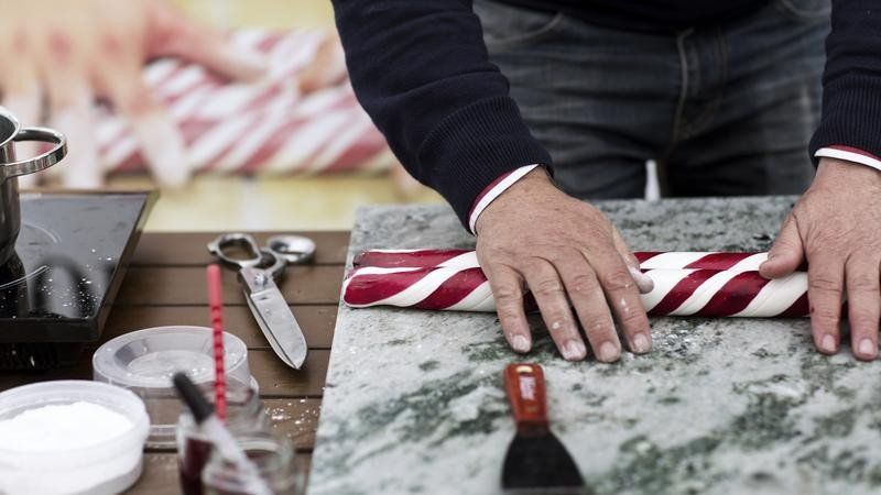
Gränna , Zweden
Gränna, known for its famous red and white mint candy canes. In the town you will find several bakeries where you can buy the delicacy, but also learn everything about the preparation process.
Brahegatan 73, 563 32 Gränna, Zweden
58° 1' 30.1" N 14° 28' 12.3" E
58.0250234 14.4700948
• Head northeast on Brahegatan. Go for 2.1 km.
• Continue on Uppgränna. Go for 1.3 km.
• Continue on Uppgränna kvarn. Go for 69 m.
• Continue on Uppgränna. Go for 372 m.
• Continue on Uppgränna Toragård. Go for 74 m.
• Turn left onto Uppgränna Knutagård. Go for 38 m.
• Continue on Uppgränna Skermagård. Go for 498 m.
• Continue on Uppgränna gästgivaregård. Go for 255 m.
• Continue on Uppgränna. Go for 191 m.
• Continue on Uppgränna Sjösnäs. Go for 379 m.
• Continue on Uppgränna Sjöhagen. Go for 1.3 km.
• Continue on Boeryd. Go for 1.5 km.
• Continue on Boeryd. Go for 451 m.
• Continue on Getingaryd Rastaborg. Go for 178 m.
• Continue on Getingaryd. Go for 2.1 km.
• Continue on Narbäck Fridhem. Go for 1.1 km.
• Continue on Holkaberg Sjöberga. Go for 1.5 km.
• Continue on Stava. Go for 521 m.
• Continue on Stava. Go for 396 m.
• Continue on Stava Utsikten. Go for 148 m.
• Turn right onto Stava Vilhelmsro. Go for 216 m.
• Turn right toward E4. Go for 242 m.
• Take ramp onto E4 toward Stockholm. Go for 11.2 km.
• Take exit 106 toward Vadstena/Ödeshög/Östgötaporten. Go for 347 m.
• Take the 3rd exit from Trafikplats Ödeshög roundabout onto Bergslagsdiagonalen. Go for 778 m.
• Pass 2 roundabouts and continue on Ödeshögsvägen. Go for 29.4 km.
• Continue on Södra vägen. Go for 592 m.
• Turn left onto Slottsgatan. Go for 230 m.
• Turn right onto Knivsmedsgatan. Go for 180 m.
• Arrive at Knivsmedsgatan. Your destination is on the left.
☍
57,7 km
( 49 min.)
Vadstena, Zweden
Vadstena, a medieval town with breathtaking views of Lake Vättern.
In the town you will find a well-preserved Renaissance castle and a beautiful monastery, the St. Birgitta. For centuries this has been the cultural and commercial center and traded glassware and handmade lace. These crafts can still be found in the local boutiques. In addition to the historical highlights, there is a lot of nature around Vadstena. In the area you will find two large lakes with long sandy beaches, rolling cornfields and wild animals.
Camper stop check a little further on the route Linkoping Friluftmuseet , Tunnbindaregatan 1, 582 46 Linköping, Sweden
and
Cafe Tannefors slussar "sluscafet"
Forshemsgatan 7, 582 44 Linkoping, Sweden
and P SAAB Arena, 582 78 Linkoping, Sweden
Helgeandsgatan 15D, 592 30 Vadstena, Zweden
58° 26' 51.4" N 14° 53' 24.8" E
58.4476022 14.8902335
• Head northeast on Knivsmedsgatan. Go for 58 m.
• Continue on Fyllagatan. Go for 93 m.
• Turn left onto Strågatan. Go for 56 m.
• Turn right onto Storgatan. Go for 93 m.
• Continue on Motalagatan. Go for 853 m.
• Turn right onto Birgittas väg. Go for 369 m.
• Turn left onto Skänningevägen (206) toward Linköping/Skänninge/Kvarnbacken. Go for 1.1 km.
• Pass 2 roundabouts and continue on 206. Go for 13.5 km.
• Take the 3rd exit from roundabout onto 206. Go for 12.0 km.
• Turn left and take ramp onto E4 toward Stockholm/Linköping. Go for 55.5 km.
• Take exit 119 toward Kalmar/E22/Arkösund/209/Norrköping S C/Sjukhus/Flygplats. Go for 505 m.
• Continue on Trafikplats Borg (E22). Go for 1.7 km.
• Take ramp toward Sjukhus/Kalmar/Flygplats/210/Arkösund/Centrum. Go for 229 m.
• Take the 2nd exit from roundabout onto Linköpingsvägen (E4.6) toward Kneippen. Go for 1.2 km.
• Continue on E4.6. Go for 38 m.
• Continue on Södra Promenaden (E4.6). Go for 393 m.
• Take the 2nd exit from Fenixrondellen roundabout onto Södra Promenaden (E4.6). Go for 1.1 km.
• Turn left onto Kristinagatan. Go for 335 m.
• Turn left onto Hantverkaregatan. Go for 36 m.
• Arrive at Hantverkaregatan. Your destination is on the right.
☍
89,3 km
(1 hrs. 6 min.)
Norrköping, Zweden
The Industrial Landscape
Hantverkaregatan 43b, 602 32 Norrköping, Zweden
58° 35' 15.9" N 16° 11' 32.7" E
58.5877450 16.1924210
• Head toward Kristinagatan on Hantverkaregatan. Go for 405 m.
• Turn left onto Östra Promenaden (E4.8). Go for 1.1 km.
• Pass 2 roundabouts and continue on Ståthögavägen (E4.8). Go for 2.4 km.
• Take the 1st exit from Sandbyhovsrondellen roundabout onto Stockholmsvägen (E4.8) toward E4. Go for 223 m.
• Take the 2nd exit from Ingelstarondellen roundabout onto Stockholmsvägen (E4.8) toward E4/51/55/56. Go for 1.6 km.
• Continue on Stockholmsvägen. Go for 315 m.
• Continue toward Trafikplats Norrköping norra. Go for 297 m.
• Continue on Trafikplats Norrköping norra. Go for 395 m.
• Continue on E4 (Trafikplats Norrköping norra). Go for 122 km.
• Take exit 144 toward Nynäshamn. Go for 423 m.
• Turn right onto 225 toward Nynäshamn/Gärtuna. Go for 1.0 km.
• Take the 2nd exit from roundabout onto 225 toward Nynäshamn/Gärtuna. Go for 8.8 km.
• Take the 1st exit from roundabout onto Nynäsvägen (225) toward Nynäshamn. Go for 3.9 km.
• Turn left onto Rosenhill (257) toward Västerhaninge/Tungelsta/Hemfosa/Norrga kvarn. Go for 2.5 km.
• Turn left onto 257 toward Västerhaninge/Tungelsta. Go for 13.3 km.
• Turn right onto Tungelstavägen. Go for 411 m.
• Continue on Trädgårdsvägen. Go for 75 m.
• Turn left onto Ålstavägen. Go for 156 m.
• Turn right onto Ålstavägen. Go for 80 m.
• Turn left onto Vretalundsvägen. Go for 319 m.
• Arrive at Vretalundsvägen. Your destination is on the right.
☍
160,3 km
(1 hrs. 53 min.)
Vretalundsvägen 42, 137 56 Tungelsta, Zweden
59° 5' 59.8" N 18° 1' 59.5" E
59.0999352 18.0331928
• Head toward Strömbergavägen on Vretalundsvägen. Go for 319 m.
• Turn right onto Ålstavägen. Go for 80 m.
• Turn left onto Ålstavägen. Go for 156 m.
• Turn right onto Trädgårdsvägen. Go for 75 m.
• Continue on Tungelstavägen. Go for 411 m.
• Continue on Gamla Stockholmsvägen (257). Go for 4.4 km.
• Take the 1st exit from roundabout onto Nynäsvägen (257) toward Stockholm/73/Nynäshamn/Centrum. Go for 363 m.
• Take the 2nd exit from roundabout onto Österhaningevägen (257) toward Stockholm/Nynäshamn/Dalarö. Go for 1.3 km.
• Turn left and take ramp onto 73 toward Stockholm. Go for 25.2 km.
• Keep right onto Herkulesgatan toward Nybroplan. Go for 182 m.
• Keep right onto Herkulesgatan toward Tegelbacken/Gustav Adolfs Torg. Go for 88 m.
• Continue on Herkulesgatan. Go for 17 m.
• Continue on Herkulesgatan. Go for 239 m.
• Turn right onto Malmtorgsgatan. Go for 198 m.
• Arrive at Gustav Adolfs torg. Your destination is on the left.
☍
33,2 km
( 32 min.)
Stockholm, Zweden
Immerse yourself one last time in the beautiful history of the city. Stroll through the narrow streets of Gamla Stan or view the beautiful works of Dali in the Moderna Museet. If you prefer peace and quiet, you can also drive from Vadstena towards the coast near Stockholm and experience a part of the beautiful archipelago. Just outside the city limits, an archipelago of about thirty thousand (!) islands awaits you. The last night you will stay in the center of Stockholm
The historic district of Gamla Stan is the historic center of the city . You are catapulted back in time.
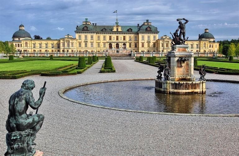
Drottningholm Castle
Drottningholm Castle is one of the biggest attractions in Stockholm. This royal palace was built in the seventeenth century by analogy with the French and Italian buildings of the time. The palace therefore resembles Versailles . Around the castle are beautifully landscaped gardens with a Chinese pavilion that Queen Louisa Ulrika received for her birthday in 1753.
Gustav Adolfs torg 24, 111 52 Stockholm, Zweden
59° 19' 45.6" N 18° 4' 6.9" E
59.3293235 18.0685808
• Head southeast on Gustav Adolfs torg. Go for 48 m.
• Continue on Strömgatan. Go for 18 m.
• Turn left onto Gustav Adolfs torg. Go for 60 m.
• Turn left onto Arsenalsgatan. Go for 20 m.
• Turn right onto Regeringsgatan. Go for 64 m.
• Turn left onto Jakobsgatan. Go for 319 m.
• Continue on Tegelbacken. Go for 209 m.
• Continue on Tegelbacken. Go for 20 m.
• Continue on Klara Mälarstrand. Go for 46 m.
• Turn right onto Blekholmsgatan toward E4/E20. Go for 337 m.
• Turn left toward Blekholmstunneln. Go for 21 m.
• Continue on Blekholmstunneln. Go for 292 m.
• Keep left onto Blekholmstunneln. Go for 2.1 km.
• Take left ramp onto E4/E20 (Norra Länken) toward E10/Norrtull. Go for 745 m.
• Keep left onto E4 (Hagatunneln) toward Sundsvall/E18/Flygplats. Go for 6.5 km.
• Continue on E4 (Uppsalavägen). Go for 123 m.
• Take the exit toward Oslo onto E18 (Kymlingelänken). Go for 64.1 km.
• Take exit 142 toward Mora/Sala. Go for 357 m.
• Turn right onto Salavägen (70) toward Mora/Sala. Go for 308 m.
• Take the 2nd exit from roundabout onto 70 toward Mora/Sala. Go for 38.8 km.
• Take the 2nd exit from roundabout onto 56/70. Go for 3.6 km.
• Take the 2nd exit from Evelunds Cirkulationsplats roundabout onto 70 toward Mora/Norberg. Go for 57.3 km.
• Pass 6 roundabouts and continue on 70. Go for 39.5 km.
• Take the 3rd exit from Grådarondellen roundabout onto Bergslagsdiagonalen (E16) toward Oslo/Örebro/Mora. Go for 744 m.
• Pass 8 roundabouts and continue on E16. Go for 20.8 km.
• Take the 2nd exit from roundabout onto 70 toward Mora. Go for 33.6 km.
• Turn left onto Tällbergsvägen toward Tällberg. Go for 1.1 km.
• Continue on Plintsberg Tällbergsvägen. Go for 279 m.
• Continue on Plintsberg Plintsbergsvägen. Go for 85 m.
• Continue on Plintsberg Tällbergsvägen. Go for 107 m.
• Continue on Plintsberg Tällbergsvägen. Go for 769 m.
• Continue on Tällbergsvägen. Go for 1.0 km.
• Turn slightly right onto Tällbergsvägen. Go for 288 m.
• Arrive at Tällbergsvägen. Your destination is on the left.
☍
273,7 km
(3 hrs. 14 min.)
Tällberg, Zweden
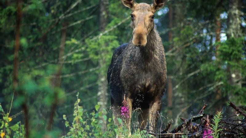
During a walk you should not be surprised if you spot one of the Swedish Big Five (moose, wolf, lynx, bear or wolverine). Tällberg, on the edge of Lake Siljan. This is the largest lake in Dalarna and has a huge scope, where you have beautiful routes to explore. Around the lake you will find idyllic views, beaches and typical Swedish villages such as Leksand, Orsa and Mora. Tällberg is authentic and peaceful and was the place to retreat for the famous Danish fairy tale writer Hans Christian Andersen. He lost his heart to this village in 1850 and came here mainly to enjoy the peace and conviviality. The lake is ideal for various outdoor activities. Start your stay calmly with a nice walk along one of the banks or rent a canoe and paddle across the lake. Enjoy the photogenic red houses along the banks.
Leksand a village before Tallberg... This village is also considered the most traditional in Dalarna and is known for its crispbread brand. Take a look at the crispbread factory and learn everything about the crispy and airy piece of “bread”. From Leksand you can discover the rolling landscape by bike and you will pass about fifty villages and hamlets. Make an occasional stop for a Swedish fika or a cozy picnic.
Sjögattu 2, 793 70 Tällberg, Zweden
60° 49' 34" N 14° 59' 31.5" E
60.8260976 14.9920858
• Head east on Tällbergsvägen. Go for 1.3 km.
• Continue on Plintsberg Tällbergsvägen. Go for 772 m.
• Continue on Plintsberg Tällbergsvägen. Go for 104 m.
• Continue on Plintsberg Plintsbergsvägen. Go for 85 m.
• Continue on Plintsberg Tällbergsvägen. Go for 279 m.
• Continue on Tällbergsvägen. Go for 1.1 km.
• Turn left onto 70. Go for 8.7 km.
• Pass 6 roundabouts and continue on 70. Go for 35.4 km.
• Take the 2nd exit from roundabout onto E45 toward Mora. Go for 1.4 km.
• Pass 2 roundabouts and continue on Vasagatan (E45). Go for 733 m.
• Take the 2nd exit from Cirkulationsplats Stranden roundabout onto Älvgatan (70). Go for 504 m.
• Pass 3 roundabouts and continue on Dalgatan (70). Go for 42.1 km.
• Turn right onto Klittenvägen toward Sveg/Lillhärdal/Klitten. Go for 11 m.
• Continue on Rotvägen. Go for 540 m.
• Continue on Kvarnvägen. Go for 97 m.
• Continue on Klittenvägen. Go for 415 m.
• Turn right onto Klittenvägen. Go for 1.3 km.
• Continue toward Nylinvägen. Go for 389 m.
• Continue on Nylinvägen. Go for 92 m.
• Continue toward Klittenvägen. Go for 290 m.
• Continue on Klittenvägen. Go for 1.7 km.
• Continue on Klittenvägen. Go for 834 m.
• Continue on Klittenvägen. Go for 2.3 km.
• Turn left. Go for 1.6 km.
• Turn left toward Göransbodarna. Go for 4.2 km.
• Continue on Göransbodarna. Go for 433 m.
• Turn slightly right. Go for 2.0 km.
• Turn right. Go for 798 m.
• Arrive at your destination on the right.
☍
109,4 km
(1 hrs. 51 min.)
Leksand/Dalarna Zweden
Leksand This village is considered to be the most traditional in Dalarna and is known for its crispbread brand. Take a look at the crispbread factory and learn everything about the crispy and airy piece of “bread”. From Leksand you can discover the rolling landscape by bike and you will pass about fifty villages and hamlets. Make a stop every now and then for a Swedish fika or a cozy picnic
85P7+JJ Dalarna, Zweden
61° 20' 11.4" N 14° 9' 50.4" E
61.3365000 14.1640100
• Head west. Go for 798 m.
• Turn left toward Göransbodarna. Go for 2.0 km.
• Turn slightly left onto Göransbodarna. Go for 433 m.
• Continue straight ahead. Go for 4.2 km.
• Turn right. Go for 1.6 km.
• Turn right toward Klittenvägen. Go for 1.1 km.
• Continue on Klittenvägen. Go for 2.0 km.
• Continue toward Klittenvägen. Go for 1.5 km.
• Continue on Klittenvägen. Go for 153 m.
• Continue toward Nylinvägen. Go for 290 m.
• Continue on Nylinvägen. Go for 481 m.
• Continue on Klittenvägen. Go for 1.3 km.
• Turn right toward Lugnkrok. Go for 10.5 km.
• Continue on Lugnkrok. Go for 3.1 km.
• Continue on Jöllen. Go for 9.0 km.
• Continue on Rymdalen. Go for 7.4 km.
• Continue on Kölkojan. Go for 6.8 km.
• Continue on Munkhäden. Go for 2.6 km.
• Continue on Ulvsjön. Go for 8.4 km.
• Continue on Smedjegatan. Go for 3.2 km.
• Continue on Olingskog. Go for 18.4 km.
• Continue on Åsen Oppibygget. Go for 273 m.
• Continue on Åsen. Go for 591 m.
• Continue on Åsen. Go for 302 m.
• Continue on Åsen. Go for 368 m.
• Continue on Åsen. Go for 411 m.
• Continue on Åsen. Go for 3.1 km.
• Continue on Sunnanå. Go for 497 m.
• Continue on Sunnanå. Go for 634 m.
• Continue on Olov Högmans väg. Go for 159 m.
• Turn right onto Olov Högmans väg. Go for 266 m.
• Continue on Härjulfs väg. Go for 969 m.
• Continue on Nordanhå. Go for 1.2 km.
• Continue on Nordanhå. Go for 26.1 km.
• Turn sharp left onto Ulvkälla (E45). Go for 1.3 km.
• Turn right onto Vallarvägen (E45) toward Östersund/Hudiksvall/Flygplats. Go for 122 km.
• Turn left onto Lillhallen (321) toward Åre/Mattmar/Svenstavik. Go for 76.2 km.
• Turn left onto E14 toward Trondheim/Åre/Järpen/Mattmar. Go for 34.6 km.
• Turn left onto Stamgärde. Go for 666 m.
• Arrive at Stamgärde.
☍
354,5 km
(4 hrs. 26 min.)
Åreälven, Zweden
874F+R7 Undersåker, Zweden
63° 18' 25.4" N 13° 16' 23.6" E
63.3070437 13.2732259
• Head east on Stamgärde. Go for 666 m.
• Turn left onto Stamgärde (E14). Go for 27.6 km.
• Turn right onto 322 toward Sandvika/Norge/Skalstugan/Norge Verdal. Go for 6.4 km.
• Turn right onto Tännforsen. Go for 1.8 km.
• Arrive at your destination.
☍
36,5 km
( 32 min.)
Tännforsen, Zweden
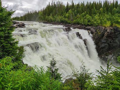
The Tännforsen is one of the highest waterfalls in Sweden . The water thunders down no less than 38 meters. The waterfall is also located in a dense coniferous forest , which only increases the fairytale quality of the place. Moreover, in winter the waterfall freezes completely, a unique view.
Åreälven, 830 15 Duved, Zweden
63° 26' 42.9" N 12° 44' 25.5" E
63.4452579 12.7404099
• Head northwest. Go for 204 m.
• Turn right onto Tännforsen. Go for 1.7 km.
• Turn left onto 322. Go for 6.4 km.
• Turn left onto E14. Go for 90.2 km.
• Take the 3rd exit from roundabout onto Föllingevägen (339) toward Valsjöbyn/Krokom/Föllinge/Änge. Go for 1.3 km.
• Take the 2nd exit from roundabout onto Föllingevägen (339). Go for 3.7 km.
• Turn right onto Näsevägen toward Lit/Åskott/Aspåsnäset. Go for 2.5 km.
• Continue on Aspåsnäset. Go for 949 m.
• Continue on Aspåsnäset. Go for 704 m.
• Continue on Aspåsnäset. Go for 1.2 km.
• Continue on Aspåsnäset. Go for 663 m.
• Continue on Aspåsnäset. Go for 5.3 km.
• Continue on Litsnäset. Go for 4.5 km.
• Continue on Klösta. Go for 765 m.
• Continue toward Östersundsvägen. Go for 4.1 km.
• Continue on Östersundsvägen. Go for 90 m.
• Turn left onto E45. Go for 39.2 km.
• Turn right toward Ramsele/Skyttmon/344. Go for 907 m.
• Continue on Ede. Go for 512 m.
• Continue on Ede. Go for 343 m.
• Turn right onto Ede (344). Go for 2.8 km.
• Turn left toward Görvikskvarnen. Go for 8.8 km.
• Continue on Görvikskvarnen. Go for 4.3 km.
• Continue on Görvik. Go for 1.1 km.
• Continue on Görvik. Go for 4.1 km.
• Continue on Sörviken. Go for 5.2 km.
• Continue on Sörviken. Go for 5.6 km.
• Continue on Sörviken. Go for 11.4 km.
• Continue on Vallen. Go for 546 m.
• Continue on Vallen. Go for 2.3 km.
• Continue on Vallen. Go for 268 m.
• Continue on Vallen. Go for 6.9 km.
• Turn right onto 345. Go for 6.1 km.
• Turn right onto Krångvägen (331/341). Go for 3.0 km.
• Turn left onto Näsåkersvägen. Go for 10.6 km.
• Continue on Imfors. Go for 793 m.
• Turn left onto Forsmo. Go for 1.2 km.
• Turn right toward Betåsen. Go for 6.5 km.
• Continue on Betåsen. Go for 2.6 km.
• Turn left onto 90. Go for 5.1 km.
• Arrive at 90.
☍
254,6 km
(3 hrs. 6 min.)
Gårelehöjden, Zweden
Cor Buissant des Amorie responds to FB
Unnamed Road
880 30, Nasaker, Sweden
Gårelehojden
beautiful, but secluded location - on a river - wooded area - water refueling possible, on the way to the seaside resort at the first house [after 30m] right at the rear, just ask before use - pets on a leash - small contribution desired - center 21km
Gårelehöjden, 880 30 Näsåker, Zweden
63° 35' 59" N 16° 49' 3" E
63.5997182 16.8175117
• Head north on 90. Go for 13.9 km.
• Turn right onto Köpmangatan (90) toward Vilhelmina. Go for 540 m.
• Turn left onto Åselevägen (90) toward Vilhelmina/Åsele. Go for 65.8 km.
• Take the 2nd exit from roundabout onto Vilhelminavägen (90) toward Dorotea/Centrum/Vilhelmina. Go for 45.8 km.
• Turn right onto Meselefors (E45) toward Arvidsjaur/Storuman/Vilhelmina. Go for 90.2 km.
• Turn left onto Blå vägen (E12/E45). Go for 1.0 km.
• Turn left onto Stenselevägen. Go for 92 m.
• Turn right onto Skolgatan. Go for 216 m.
• Turn left onto Köpmangatan. Go for 82 m.
• Turn right onto Järnvägsgatan. Go for 89 m.
• Arrive at Järnvägsgatan. Your destination is on the right.
☍
217,8 km
(2 hrs. 23 min.)
Storuman, Zweden
Järnvägsgatan 18, 923 31 Storuman, Zweden
65° 5' 44.2" N 17° 6' 44.2" E
65.0956204 17.1122771
• Head northeast on Järnvägsgatan. Go for 132 m.
• Turn right onto Stationsgatan. Go for 90 m.
• Turn left onto Skolgatan. Go for 63 m.
• Turn right onto Torggatan. Go for 83 m.
• Turn left onto Blå vägen (E12/E45). Go for 419 m.
• Turn right onto E45 toward Arvidsjaur. Go for 144 km.
• Turn right onto Inlandsvägen (E45) toward Flygplats/Arvidsjaur/Skellefteå. Go for 7.9 km.
• Take the 2nd exit from roundabout onto Inlandsvägen (E45) toward Gällivare/Jokkmokk. Go for 152 km.
• Take the 2nd exit from roundabout onto Klockarvägen (E45) toward Gällivare. Go for 93.0 km.
• Take the 1st exit from roundabout onto Lasarettsgatan toward Sjukhus. Go for 325 m.
• Continue on Luleåvägen. Go for 158 m.
• Take the 2nd exit from roundabout onto Nuolajärvivägen. Go for 1.7 km.
• Take the 2nd exit from roundabout onto Inlandsvägen (E45). Go for 8.8 km.
• Turn left onto Inlandsvägen (E10/E45) toward Karesuando/Kiruna. Go for 61.5 km.
• Continue on Etian (E10) toward Kiruna. Go for 35.8 km.
• Turn right onto Marknadsvägen toward Esrange/Jukkasjärvi/Icehotel/Laxforsen. Go for 6.3 km.
• Arrive at Marknadsvägen. Your destination is on the right.
☍
512,0 km
(5 hrs. 56 min.)
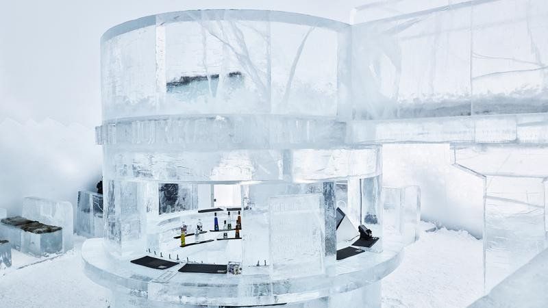
Jukkasjärvi, Zweden
ice hotel
A visit to a husky kennel or opt for a relaxed sauna afternoon.
Underground iron ore mine in Kiruna
It's like a city underground. This means the largest underground iron ore mine in the world in Kiruna. During this tour, the bus will take you to a depth of 500 meters. During the tour, the guide will tell you more about the production, the evacuation plan, the history and that modern mining can even cause an entire city to be moved. In the mining environment you get an even better picture through the displays, films and the machines used for ore mining and iron production. Suitable for 6 years and older.
Included: guide, snack. Duration: 2.5 hours. Departure times: from June 1 to October 31 on Tuesdays, Thursdays and Saturdays. Tip: It can be cold in the mine, so bring a sweater
Nybyggarvägen 6-26, 981 91 Jukkasjärvi, Zweden
67° 51' 0.7" N 20° 36' 8" E
67.8501828 20.6022146
• Head west on Marknadsvägen. Go for 6.3 km.
• Turn left onto E10. Go for 35.8 km.
• Turn left onto Inlandsvägen (E45) toward Pajala/Karesuando/Svappavaara. Go for 24.7 km.
• Continue on 395 toward Pajala. Go for 54.7 km.
• Turn left onto Kangosvägen toward Muodoslompolo/Parkalompolo/Keräntöjärvi/Kangos. Go for 7.6 km.
• Continue on Kangosvägen. Go for 1.5 km.
• Continue on Östra Kangos. Go for 12.3 km.
• Continue on Hukanmaa. Go for 1.1 km.
• Continue on Hukanmaa. Go for 35.8 km.
• Turn left onto Kitkiöjoki (99). Go for 27.4 km.
• Turn right onto Muoniovägen (404). Go for 13.8 km.
• Continue on Tullitie (954). Go for 221 m.
• Turn left onto Torniontie (E8) toward Kilpisjärvi/Enontekiö/Keskusta. Go for 2.0 km.
• Turn right onto Rovaniementie (79) toward Rovaniemi/Kittilä. Go for 61.5 km.
• Take the 2nd exit from roundabout onto Levintie (79) toward Kittilä. Go for 2.1 km.
• Turn left onto Tunturitie toward Levihuippu/Kouta. Go for 4.6 km.
• Turn left. Go for 64 m.
• Arrive at your destination.
☍
291,5 km
(3 hrs. 46 min.)
Vielma/Levi, Finland
Levi, a small but lively village. The center of Levi has been given its own name: Sirkka; you will find many restaurants and shops.
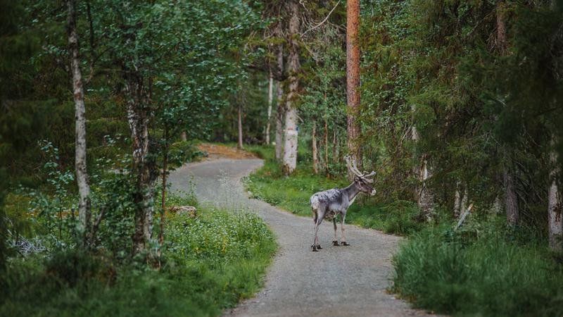
In summer this is a perfect area for outdoor activities. One of the Finnish specialties is, of course, reindeer. There are a number of restaurants in the center that prepare reindeer according to family recipes. Highly recommended!
QVM9+84 Vielma, Finland
67° 46' 59.8" N 24° 52' 4.2" E
67.7832872 24.8678286
• Head toward Tunturitie. Go for 64 m.
• Turn right onto Tunturitie. Go for 4.6 km.
• Turn left onto Levintie (79). Go for 17.3 km.
• Turn left onto Sodankyläntie (80) toward Sodankylä. Go for 84.9 km.
• Turn left onto Rovaniementie (E75) toward Ivalo/Sodankylä. Go for 675 m.
• Take the 2nd exit from roundabout onto Sodankyläntie (E75) toward Ivalo. Go for 899 m.
• Take the 2nd exit from roundabout onto Ivalontie (E75) toward Ivalo. Go for 127 km.
• Turn right onto Saariseläntie (9693) toward Saariselkä/Suolocielgi. Go for 535 m.
• Take the 1st exit from roundabout onto Saariseläntie (9693). Go for 90 m.
• Arrive at Saariseläntie (9693). Your destination is on the left.
☍
236,6 km
(2 hrs. 52 min.)
Saariselkä, Finland
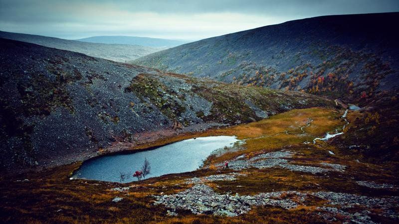
Saariselkä is nestled amid breathtaking yet rugged hillside scenery in the Urho Kekkonen National Park. In this national park there are various walks that take you along various lakes and steep gorges. The gorges were created by the meltwater from the Ice Age. Put on your hiking boots and discover the diversity of the park.
Saariseläntie 2, 99830 Inari, Finland
68° 25' 10.8" N 27° 24' 36" E
68.4196636 27.4100029
• Head west on Saariseläntie (9693). Go for 84 m.
• Take the 2nd exit from roundabout onto Saariseläntie (9693). Go for 577 m.
• Turn right onto Rovaniementie (E75) toward Rovaniemi. Go for 31.0 km.
• Pass 3 roundabouts and continue on Ivalontie (E75). Go for 165 km.
• Turn right onto Nuorgamintie (970) toward Nuorgam/Njuorggán. Go for 47.1 km.
• Continue on Polmakveien (895). Go for 18.5 km.
• Turn right onto E6/E75. Go for 13.5 km.
• Turn right toward Kirkenes. Go for 10 m.
• Take the 1st exit from roundabout onto Rávttebelgeainu (E6) toward Kirkenes. Go for 708 m.
• Turn right onto Tangnesveien. Go for 249 m.
• Arrive at Tangnesveien.
☍
276,6 km
(3 hrs. 13 min.)
Varangerbotn, Noorwegen
5H72+PP Varangerbotn, Noorwegen
70° 9' 51.5" N 28° 33' 6.6" E
70.1643143 28.5518210
• Head northeast on Tangnesveien. Go for 249 m.
• Turn left onto Rávttebelgeainu (E6). Go for 699 m.
• Take the 1st exit from roundabout onto E75 toward Vardø. Go for 31.4 km.
• Continue on Nordvarangerveien (E75). Go for 455 m.
• Continue on E75. Go for 291 m.
• Continue on Nordvarangerveien (E75). Go for 2.5 km.
• Continue on E75. Go for 229 m.
• Continue on Nordvarangerveien (E75). Go for 5.1 km.
• Continue on E75. Go for 32 m.
• Continue on Nordvarangerveien (E75). Go for 3.3 km.
• Continue on E75. Go for 2.1 km.
• Continue on Nordvarangerveien (E75). Go for 1.9 km.
• Continue on E75. Go for 740 m.
• Continue on Tanavegen (E75). Go for 1.5 km.
• Continue on Havnegata (E75). Go for 889 m.
• Continue on Hvistendalsgate (E75). Go for 228 m.
• Take the 2nd exit from roundabout onto Hvistendalsgate (E75). Go for 953 m.
• Continue on Vardøvegen (E75). Go for 942 m.
• Continue on E75. Go for 2.0 km.
• Continue on Nordvarangerveien (E75). Go for 8.0 km.
• Continue on E75. Go for 6.4 km.
• Continue on Nordvarangerveien (E75). Go for 381 m.
• Continue on E75. Go for 118 m.
• Continue on Nordvarangerveien (E75). Go for 695 m.
• Continue on E75. Go for 52.2 km.
• Continue on Vardøtunnelen (E75). Go for 2.9 km.
• Continue on E75. Go for 228 m.
• Continue on Brodtkorbs gate. Go for 108 m.
• Turn right onto Kristian 4 gate. Go for 193 m.
• Continue on Kristian 4 gate. Go for 33 m.
• Turn left toward Idrettsgata. Go for 185 m.
• Turn left onto Idrettsgata. Go for 158 m.
• Continue straight ahead. Go for 817 m.
• Arrive at your destination.
☍
128,1 km
(1 hrs. 41 min.)
Vardø, Noorwegen
942M+9M Vardø, Noorwegen
70° 21' 3.6" N 31° 8' 3" E
70.3509914 31.1341659
• Head toward Idrettsgata. Go for 817 m.
• Continue on Idrettsgata. Go for 158 m.
• Turn right toward Søndre Berggate. Go for 52 m.
• Turn right onto Søndre Berggate. Go for 202 m.
• Turn left onto Skolegata. Go for 104 m.
• Continue on Brodtkorbs gate. Go for 166 m.
• Continue on E75. Go for 228 m.
• Continue on Vardøtunnelen (E75). Go for 2.9 km.
• Continue on E75. Go for 52.2 km.
• Continue on Nordvarangerveien (E75). Go for 695 m.
• Continue on E75. Go for 118 m.
• Continue on Nordvarangerveien (E75). Go for 381 m.
• Continue on E75. Go for 6.4 km.
• Continue on Nordvarangerveien (E75). Go for 8.0 km.
• Continue on E75. Go for 2.0 km.
• Continue on Vardøvegen (E75). Go for 942 m.
• Continue on Hvistendalsgate (E75). Go for 922 m.
• Take the 2nd exit from roundabout onto Hvistendalsgate (E75). Go for 258 m.
• Continue on Havnegata (E75). Go for 889 m.
• Continue on Tanavegen (E75). Go for 1.5 km.
• Continue on E75. Go for 740 m.
• Continue on Nordvarangerveien (E75). Go for 1.9 km.
• Continue on E75. Go for 2.1 km.
• Continue on Nordvarangerveien (E75). Go for 3.3 km.
• Continue on E75. Go for 32 m.
• Continue on Nordvarangerveien (E75). Go for 5.1 km.
• Continue on E75. Go for 229 m.
• Continue on Nordvarangerveien (E75). Go for 2.5 km.
• Continue on E75. Go for 291 m.
• Continue on Nordvarangerveien (E75). Go for 455 m.
• Continue on E75. Go for 31.4 km.
• Take the 2nd exit from roundabout onto E6/E75. Go for 13.6 km.
• Turn left onto Polmakveien (895) toward Buolbmát/Polmak. Go for 18.5 km.
• Continue on 970. Go for 47.1 km.
• Turn right onto E75 toward E6. Go for 270 m.
• Continue on Samelandsbrua (E75). Go for 760 m.
• Turn left onto E6 toward Alta/Karasjohka/Karasjok. Go for 113 km.
• Turn left onto Piera Biret geaidnu. Go for 49 m.
• Arrive at Piera Biret geaidnu. Your destination is on the left.
☍
320,0 km
(3 hrs. 53 min.)
Karasjok, Zweden
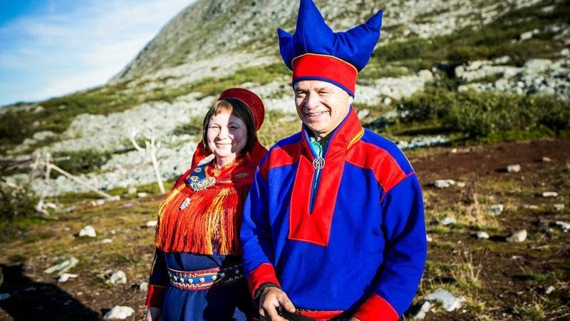
Karasjok. About 90% of the local population speaks Sami and the area is home to about 60,000 reindeer. Visit an authentic Sami family, see the reindeer and hear stories about past and present Sami culture. Sample Sami dishes such as bidos, a traditional reindeer stew, and hear the fascinating stories of the Sami.
Piera Biret Geaidnu 7A, 9730 Karasjok, Noorwegen
69° 28' 16.9" N 25° 30' 46.5" E
69.4713588 25.5129263
• Head toward Skuvllaluodda on Piera Biret geaidnu. Go for 90 m.
• Turn right onto Skuvllaluodda. Go for 94 m.
• Turn right onto Suomageaidnu (92). Go for 109 m.
• Take the 3rd exit from roundabout onto Kautokeinoveien (E6) toward Alta/Leavdnja/Lakselv/92/Guovdageaidnu/Kautokeino. Go for 350 m.
• Take the 1st exit from roundabout onto Leavnnjageaidnu (E6) toward Alta/Leavdnja/Lakselv. Go for 73.4 km.
• Take the 3rd exit from roundabout onto E6 toward Alta. Go for 48.1 km.
• Keep right toward E6. Go for 1.7 km.
• Turn right onto E6. Go for 13.9 km.
• Continue on E69 toward Nordkapp/Honningsvåg. Go for 2.6 km.
• Continue on Øverland (E69). Go for 113 m.
• Continue on E69. Go for 4.6 km.
• Continue on Solberg (E69). Go for 84 m.
• Continue on E69. Go for 8.6 km.
• Continue on Sørset (E69). Go for 138 m.
• Continue on E69. Go for 3.4 km.
• Continue on Skarvbergtunnelen (E69). Go for 4.7 km.
• Continue on E69. Go for 4.2 km.
• Continue on Sortviktunnelen (E69). Go for 490 m.
• Continue on E69. Go for 15.4 km.
• Continue on Stranda (E69). Go for 1.6 km.
• Continue on E69. Go for 12 m.
• Continue on Stranda (E69). Go for 1.8 km.
• Continue on E69. Go for 425 m.
• Continue on Reinelva (E69). Go for 2.7 km.
• Continue on E69. Go for 1.9 km.
• Continue on Indre Mannskarvika (E69). Go for 389 m.
• Continue on E69. Go for 8.8 km.
• Continue on Porsangervika (E69). Go for 1.3 km.
• Continue on E69. Go for 706 m.
• Continue on Porsangervika (E69). Go for 381 m.
• Continue on E69. Go for 3.2 km.
• Continue on Kåfjord (E69). Go for 6.1 km.
• Continue on E69. Go for 154 m.
• Continue on Vesterpollen (E69). Go for 44 m.
• Continue on Laholmen (E69). Go for 66 m.
• Continue on Nordkapptunnelen (E69). Go for 6.8 km.
• Continue on E69. Go for 733 m.
• Continue on Veidnesbrua (E69). Go for 675 m.
• Continue on E69. Go for 9 m.
• Continue on Sarnesveien (E69). Go for 1.5 km.
• Continue on E69. Go for 480 m.
• Continue on Sarnestunnelen (E69). Go for 225 m.
• Continue on E69. Go for 48 m.
• Continue on Sarnesveien (E69). Go for 2.6 km.
• Continue on E69. Go for 118 m.
• Continue on Ørntind (E69). Go for 371 m.
• Continue on Sarnesveien (E69). Go for 555 m.
• Continue on E69. Go for 422 m.
• Continue on Sarnesveien (E69). Go for 1.4 km.
• Continue on E69. Go for 111 m.
• Continue on Honningsvågtunnelen (E69). Go for 4.5 km.
• Continue on E69. Go for 108 m.
• Continue on Kobbhullveien (E69). Go for 1.3 km.
• Continue on E69. Go for 511 m.
• Turn right onto Nordkappveien (E69). Go for 1.9 km.
• Continue on Nordkappgata (E69). Go for 537 m.
• Arrive at Nordkappgata (E69). Your destination is on the left.
☍
236,5 km
(3 hrs. 8 min.)
Honningsvåg, Noorwegen
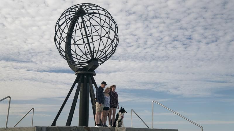
On the way, don't forget to stop at Hjemmeluft, where you can admire ancient rock carvings between 4200 and 500 BC. The area around the North Cape is fascinating, with spectacular nature and picturesque fishing villages. The North Cape itself is an island and consists of Honningsvåg, Nordvågen, Kamøyvær, Gjesvær, Skarsvåg and Repvåg on the mainland. North of the treeline, Nordkapp offers a wide variety of sights and activities, such as arctic food with fresh produce, as well as a rich history and culture. Do you want to know everything about this region? Then visit the Nordkappmusseet (North Cape Museum).
Nordkapphallen on the North Cape
Get to know the story of the North Cape, Europe's northernmost point, in the Nordkapphallen. In this visitor center you will learn more about the seasons, history, St. John's Chapel, the cave of light and the northernmost post office are also discussed. This ticket gives you access to the Panorama Film, historical exhibitions and the Cave of Lights. Don't forget to visit the restaurant, you will be treated to a fantastic view of the Arctic Ocean
Important information:
-The ticket is valid for 24 hours. -The tickets are personal and not transferable to others. - You must be in possession of a valid ID. -Parking is possible for a fee, take into account about €20 for the car. -Children under the age of five have free access. -When you travel to the North Cape in winter, you have to take convoy driving into account.
Drive past the town of Gjesvær. From here you can make an excursion to the bird island of Gjecaerstappen where you will find hundreds of puffins. You can also take a walk to the natural rock arch of Kirkeporten which immediately offers you an impressive view of the North Cape. Don't miss Skarsvåg. Nestled in a rugged landscape, this lovely fishing village is the northernmost fishing village in the world. The church in Honningsvåg is also worth a visit. This church was inaugurated in 1885 after a hurricane razed the old church in Kjelvik. The church was built in neo-Gothic style and is an important place for the population. After the war, the church was used as accommodation, bakery and kitchen, and today it symbolizes hope, courage and unity - and as a tourist attraction in Honningsvåg. Did you know that the sun shines through here continuously from mid-May to the end of July? Watch the sunset over the Barents Sea from the North Cape Plateau tonight.
If you want to visit the real northernmost tip of the mainland, you should go to Kap Knivskjellodden. This is only possible with a walk of about eighteen kilometers there and back. Follow the cairns about one and a half meters high for the right direction. You cannot miss these stones, because next to heather nothing grows. You may even see a herd of reindeer passing by.
Nordkappgata 1B, 9750 Honningsvåg, Noorwegen
70° 58' 56.2" N 25° 58' 12.7" E
70.9822909 25.9702074
• Head toward Fiskeriveien on Nordkappgata (E69). Go for 19 m.
• Take the 3rd exit from roundabout onto Nordkappgata (E69). Go for 598 m.
• Continue on Nordkappveien (E69). Go for 2.5 km.
• Continue on E69. Go for 154 m.
• Continue on Skipsfjorden (E69). Go for 5.2 km.
• Continue on E69. Go for 6.1 km.
• Turn left onto 8038. Go for 17.1 km.
• Continue on Lyngpollen (8038). Go for 1.7 km.
• Continue on 8038. Go for 1.5 km.
• Continue on Midtvegen (8038). Go for 59 m.
• Continue on Walsøenesvegen (8038). Go for 36 m.
• Arrive at Walsøenesvegen (8038).
☍
34,9 km
( 49 min.)
Glesvær, Noorwegen
Drive past the town of Gjesvær. From here you can make an excursion to the bird island Gjecaerstappen where you will find hundreds of puffins. You can also take a walk to the natural rock arch of Kirkeporten which immediately offers you an impressive view of the North Cape. Don't miss Skarsvåg. Nestled in a rugged landscape, this lovely fishing village is the northernmost fishing village in the world. The church in Honningsvåg is also worth a visit. This church was inaugurated in 1885 after a hurricane razed the old church in Kjelvik. The church was built in neo-Gothic style and is an important place for the population. After the war, the church was used as accommodation, bakery and kitchen, and today it symbolizes hope, courage and unity - and as a tourist attraction in Honningsvåg. Did you know that the sun shines through here continuously from mid-May to the end of July? Watch the sunset over the Barents Sea from the North Cape Plateau tonight.
Nygårdsvegen 1, 9765 Gjesvær, Noorwegen
71° 5' 54" N 25° 22' 33.8" E
71.0983198 25.3760455
• Head toward Midtvegen on Walsøenesvegen (8038). Go for 36 m.
• Continue on Midtvegen (8038). Go for 59 m.
• Turn left onto 8038. Go for 1.5 km.
• Continue on Lyngpollen (8038). Go for 1.7 km.
• Continue on 8038. Go for 17.1 km.
• Turn right onto E69. Go for 6.1 km.
• Continue on Skipsfjorden (E69). Go for 5.2 km.
• Continue on E69. Go for 154 m.
• Continue on Nordkappveien (E69). Go for 637 m.
• Turn right onto E69. Go for 511 m.
• Continue on Kobbhullveien (E69). Go for 1.3 km.
• Continue on E69. Go for 108 m.
• Continue on Honningsvågtunnelen (E69). Go for 4.5 km.
• Continue on E69. Go for 111 m.
• Continue on Sarnesveien (E69). Go for 1.4 km.
• Continue on E69. Go for 422 m.
• Continue on Sarnesveien (E69). Go for 555 m.
• Continue on Ørntind (E69). Go for 371 m.
• Continue on E69. Go for 118 m.
• Continue on Sarnesveien (E69). Go for 2.6 km.
• Continue on E69. Go for 48 m.
• Continue on Sarnestunnelen (E69). Go for 225 m.
• Continue on E69. Go for 480 m.
• Continue on Sarnesveien (E69). Go for 1.5 km.
• Continue on E69. Go for 9 m.
• Continue on Veidnesbrua (E69). Go for 675 m.
• Continue on E69. Go for 733 m.
• Continue on Nordkapptunnelen (E69). Go for 6.8 km.
• Continue on Laholmen (E69). Go for 66 m.
• Continue on Vesterpollen (E69). Go for 44 m.
• Continue on E69. Go for 154 m.
• Continue on Kåfjord (E69). Go for 6.1 km.
• Continue on E69. Go for 3.2 km.
• Continue on Porsangervika (E69). Go for 381 m.
• Continue on E69. Go for 706 m.
• Continue on Porsangervika (E69). Go for 1.3 km.
• Continue on E69. Go for 8.8 km.
• Continue on Indre Mannskarvika (E69). Go for 389 m.
• Continue on E69. Go for 1.9 km.
• Continue on Reinelva (E69). Go for 2.7 km.
• Continue on E69. Go for 425 m.
• Continue on Stranda (E69). Go for 1.8 km.
• Continue on E69. Go for 12 m.
• Continue on Stranda (E69). Go for 1.6 km.
• Continue on E69. Go for 15.4 km.
• Continue on Sortviktunnelen (E69). Go for 490 m.
• Continue on E69. Go for 4.2 km.
• Continue on Skarvbergtunnelen (E69). Go for 4.7 km.
• Continue on E69. Go for 3.4 km.
• Continue on Sørset (E69). Go for 138 m.
• Continue on E69. Go for 8.6 km.
• Continue on Solberg (E69). Go for 84 m.
• Continue on E69. Go for 4.6 km.
• Continue on Øverland (E69). Go for 113 m.
• Continue on E69. Go for 2.6 km.
• Turn right onto E6. Go for 23.1 km.
• Continue on Repparfjordveien (94) toward Hammerfest. Go for 53.7 km.
• Take the 2nd exit from roundabout onto Storsvingen (94). Go for 1.6 km.
• Turn left onto Sjøgata. Go for 119 m.
• Arrive at Sjøgata. Your destination is on the left.
☍
207,3 km
(3 hrs. 24 min.)
Hammerfest, Noorwegen
Best hikes to Hvaldimir
Zick-Zack-Weg Einstieg
Hiking Highlight..From the height there is a beautiful view over the city and the bay. You can also take a taxi to the viewpoint.
Eisbar Museum
Hiking Highlight....The Polar Bear Museum is a MUST visit when visiting Hammerfest. Here you can also join the polar bear club.
Gatefulle Forsol
Hiking Highlight.....The Sami once lived here. The sea level was a few meters higher than it is now.
Blick auf Hammerfest
Highlight
Easily accessible by bike; from here you have a good view of the whole city and the bay.
Sjøgata 6, 9600 Hammerfest, Noorwegen
70° 39' 48.4" N 23° 40' 55.1" E
70.6634382 23.6819665
• Head north on Sjøgata.
• Turn left onto Sørøygata. Go for 419 m.
• Turn right onto Akkarfjordveien (94). Go for 1.2 km.
• Take the 2nd exit from roundabout onto Storsvingen (94). Go for 53.7 km.
• Turn right onto Repparfjorddalen (E6). Go for 80.7 km.
• Take the 4th exit from roundabout onto Aronnesveien (870) toward Aronnes. Go for 3.9 km.
• Arrive at Aronnesveien (870). Your destination is on the left.
☍
139,9 km
(2 hrs. 7 min.)
Alta, Noorwegen
Beautiful scenery on a well traveled Trail
Review of Cecret Lake TrailI
This is a beautiful route with beautiful views of the mountains, wildflowers, the Lake of the Upper and Valleys. Many people travel this trail so don't think you have an individual experience. Some online trail guides say this is an "easy" trail. It is not, even for seasoned hikers. We had a 3 year old with us and he was able to do it but it gets steep and rocky at the top with several switchbacks. This is not for pushchairs or wheelchairs.
The parking is difficult. We were lucky enough to find a spot in the lower parking lot. There really should be a shuttle more than just two days on the weekend.
The temperature is lovely - at least 15 degrees cooler than down in the city. Lots of water and snacks. Although it is cooler you can get sunburnt so wear sunscreen or a hat or both.
It took us an hour and a half to hike slowly to the lake and an hour to get down. Without kids it would be faster but the joy is seeing things along the way, not rushing.
Dogs are not allowed on this trail and camping is not allowed near the lake as it is a watershed lake.
Well worth the walk! It is so beautiful!
Elvestrand 9, 9514 Alta, Noorwegen
69° 57' 26.4" N 23° 17' 14.1" E
69.9573328 23.2872403
• Head toward Elvestrand on Aronnesveien (870). Go for 1.1 km.
• Take the 3rd exit from roundabout onto Aronnesveien (870). Go for 331 m.
• Take the 3rd exit from roundabout onto Altaveien (E6) toward Narvik. Go for 102 km.
• Arrive at Kvænangsveien (E6). Your destination is on the left.
☍
102,9 km
(1 hrs. 26 min.)
Badderen Noorwegen
From Alta we go via the E6 in the direction of Badderen, on the way we see where we stop and where we are going to do something.
Sætra, Kvænangen kommune, Noorwegen
69° 50' 42.6" N 22° 1' 34.1" E
69.8451579 22.0261497
• Head south on Kvænangsveien (E6). Go for 58.7 km.
• Turn right onto Blomstereng. Go for 147 m.
• Arrive at Blomstereng.
☍
58,8 km
( 51 min.)
Storslett Noorwegen
Blomstereng 8A, 9151 Storslett, Noorwegen
69° 46' 19.4" N 20° 59' 47.1" E
69.7720579 20.9964203
• Head toward Engvegen on Blomstereng. Go for 123 m.
• Turn slightly right onto Blomstereng. Go for 24 m.
• Turn left onto Hovedvegen (E6). Go for 1.0 km.
• Turn right onto Høgeggvegen (865) toward Bilto/Sonjatun Sykehus. Go for 232 m.
• Take the 2nd exit from roundabout onto Høgeggvegen (865). Go for 842 m.
• Continue on 865. Go for 4.5 km.
• Continue on 865. Go for 1.2 km.
• Continue on Reisadalen (865). Go for 801 m.
• Continue on 865. Go for 530 m.
• Continue on Solberg (865). Go for 82 m.
• Continue on 865. Go for 3.9 km.
• Continue on Reisadalen (865). Go for 1.4 km.
• Continue on 865. Go for 8 m.
• Continue on Reisadalen (865). Go for 907 m.
• Continue on 865. Go for 62 m.
• Continue on Reisadalen (865). Go for 1.1 km.
• Continue on 865. Go for 319 m.
• Continue on Haugsetveien (865). Go for 570 m.
• Continue on 865. Go for 5.0 km.
• Continue on Reisadalen (865). Go for 559 m.
• Continue on 865. Go for 395 m.
• Continue on Reisadalen (865). Go for 147 m.
• Continue on Vinnelysveien (865). Go for 633 m.
• Continue on Reisadalen (865). Go for 108 m.
• Continue on 865. Go for 1.2 km.
• Turn slightly left onto Reisadalen (865). Go for 11.6 km.
• Turn left. Go for 300 m.
• Turn slightly right toward Svartfossveien. Go for 546 m.
• Continue on Svartfossveien. Go for 401 m.
• Turn slightly left toward Biltoveien. Go for 328 m.
• Continue on Biltoveien. Go for 3.4 km.
• Arrive at Biltoveien.
☍
42,2 km
(1 hrs. 5 min.)
Bilto, Noorwegen
Taking a piece of the country in lovely walks
FFW8+2R Bilto, Noorwegen
69° 29' 42.2" N 21° 28' 1.4" E
69.4950476 21.4670673
• Head north on Biltoveien. Go for 3.7 km.
• Turn slightly right onto Svartfossveien. Go for 401 m.
• Continue toward Reisadalen/865. Go for 846 m.
• Turn right onto Reisadalen (865). Go for 6.4 km.
• Turn left onto Reisadalen (865). Go for 5.2 km.
• Turn slightly right onto 865. Go for 1.2 km.
• Continue on Reisadalen (865). Go for 108 m.
• Continue on Vinnelysveien (865). Go for 633 m.
• Continue on Reisadalen (865). Go for 147 m.
• Continue on 865. Go for 395 m.
• Continue on Reisadalen (865). Go for 559 m.
• Continue on 865. Go for 2.1 km.
• Turn left onto 865. Go for 2.8 km.
• Continue on Haugsetveien (865). Go for 570 m.
• Continue on 865. Go for 319 m.
• Continue on Reisadalen (865). Go for 1.1 km.
• Continue on 865. Go for 62 m.
• Continue on Reisadalen (865). Go for 907 m.
• Continue on 865. Go for 8 m.
• Continue on Reisadalen (865). Go for 1.4 km.
• Continue on 865. Go for 680 m.
• Turn left onto 865. Go for 3.2 km.
• Continue on Solberg (865). Go for 82 m.
• Continue on 865. Go for 530 m.
• Continue on Reisadalen (865). Go for 801 m.
• Continue on 865. Go for 5.7 km.
• Continue on Høgeggvegen (865). Go for 816 m.
• Take the 2nd exit from roundabout onto Høgeggvegen (865). Go for 258 m.
• Turn left onto Sentrum (E6). Go for 150 km.
• Turn right onto E8 toward Tromsø. Go for 68.5 km.
• Take the 3rd exit from roundabout onto Bruvegen (862). Go for 1.8 km.
• Turn left onto Skippergata. Go for 278 m.
• Turn right onto Bispegata. Go for 123 m.
• Turn left onto Grønnegata. Go for 358 m.
• Turn left onto Fredrik Langes gate. Go for 48 m.
• Arrive at Fredrik Langes gate. Your destination is on the right.
☍
261,9 km
(4 hrs. 8 min.)
Tromso, Noorwegen
Storgata 64, 9008 Tromsø, Noorwegen
69° 38' 57.1" N 18° 57' 19.2" E
69.6492047 18.9553238
• Head toward Grønnegata on Fredrik Langes gate. Go for 48 m.
• Turn right onto Grønnegata. Go for 358 m.
• Turn right onto Bispegata. Go for 123 m.
• Turn left onto Skippergata. Go for 270 m.
• Turn right onto 862. Go for 1.8 km.
• Take the 1st exit from roundabout onto E8. Go for 68.5 km.
• Continue on E6. Go for 50.7 km.
• Turn right onto 855 toward Senja/Finnsnes. Go for 29.9 km.
• Continue on 86. Go for 3.5 km.
• Continue on Storgata (86). Go for 900 m.
• Turn right onto Skolegata. Go for 97 m.
• Turn left onto Smørhusbakken. Go for 285 m.
• Turn right onto Knausen. Go for 118 m.
• Arrive at Knausen. Your destination is on the left.
☍
156,5 km
(2 hrs. 6 min.)
Botnhamm Noorwegen
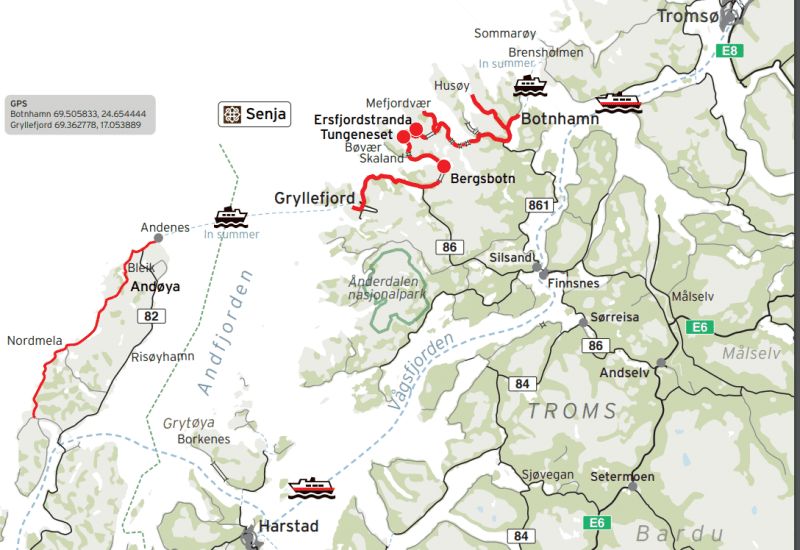
Route Senja: from Gryllefjord to Botnhamn: 102 kilometers
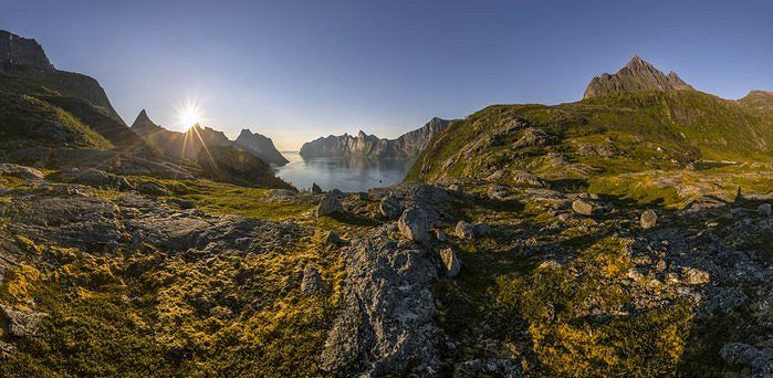
Senja is a beautiful island located north of the Arctic Circle. You will find a mix of mountains, beaches, rocky coastlines, colorful fishing villages and the northernmost zoo in the world (Polar Park)
Knausen 9, 9300 Finnsnes, Noorwegen
69° 13' 55.3" N 17° 58' 51.1" E
69.2320380 17.9808555
• Head toward Liaveien on Knausen. Go for 86 m.
• Turn left onto Liaveien. Go for 161 m.
• Turn right onto Nygårdsveien. Go for 115 m.
• Turn slightly left onto Larsbakken. Go for 150 m.
• Turn right onto Strandveien (86). Go for 845 m.
• Continue on 86. Go for 1.3 km.
• Turn right onto Vikaveien (861). Go for 1.7 km.
• Continue on 861. Go for 59 m.
• Continue on Vikaveien (861). Go for 254 m.
• Continue on 861. Go for 175 m.
• Continue on Vikaveien (861). Go for 1.1 km.
• Continue on 861. Go for 85 m.
• Continue on Vikaveien (861). Go for 370 m.
• Continue on 861. Go for 670 m.
• Continue on Vikaveien (861). Go for 848 m.
• Continue on 861. Go for 178 m.
• Continue on Vikaveien (861). Go for 272 m.
• Continue on 861. Go for 308 m.
• Continue on Vikaveien (861). Go for 107 m.
• Continue on Grasmyrveien (861). Go for 1.6 km.
• Continue on 861. Go for 43 m.
• Continue on Grasmyrveien (861). Go for 724 m.
• Continue on 861. Go for 1.1 km.
• Continue on Grasmyrveien (861). Go for 568 m.
• Continue on 861. Go for 341 m.
• Continue on Skognesveien (861). Go for 271 m.
• Continue on 861. Go for 412 m.
• Continue on Skognesveien (861). Go for 279 m.
• Continue on 861. Go for 82 m.
• Continue on Skognesveien (861). Go for 679 m.
• Continue on 861. Go for 156 m.
• Continue on Skognesbotn (861). Go for 84 m.
• Continue on 861. Go for 167 m.
• Continue on Skognesveien (861). Go for 906 m.
• Continue on 861. Go for 595 m.
• Continue on Skognesveien (861). Go for 358 m.
• Continue on 861. Go for 99 m.
• Continue on Skognesveien (861). Go for 844 m.
• Continue on 861. Go for 198 m.
• Continue on Skognesveien (861). Go for 174 m.
• Continue on 861. Go for 357 m.
• Continue on Skognesveien (861). Go for 115 m.
• Continue on 861. Go for 126 m.
• Continue on Skognesveien (861). Go for 182 m.
• Continue on 861. Go for 83 m.
• Continue on Skognesveien (861). Go for 248 m.
• Continue on 861. Go for 121 m.
• Continue on Skognesveien (861). Go for 646 m.
• Continue on 861. Go for 1.1 km.
• Continue on Skognesveien (861). Go for 405 m.
• Continue on 861. Go for 410 m.
• Continue on Landøyveien (861). Go for 1.5 km.
• Continue on 861. Go for 959 m.
• Turn left onto Skolebakken (861). Go for 81 m.
• Continue on Lysnesveien (861). Go for 4.0 km.
• Continue on 861. Go for 214 m.
• Continue on Lysnesveien (861). Go for 752 m.
• Continue on 861. Go for 157 m.
• Continue on Lysnesveien (861). Go for 536 m.
• Continue on 861. Go for 206 m.
• Continue on Lysnesveien (861). Go for 1.7 km.
• Continue on 861. Go for 298 m.
• Continue on Lysnesveien (861). Go for 2.6 km.
• Continue on 861. Go for 101 m.
• Continue on Lysnesveien (861). Go for 461 m.
• Continue on 861. Go for 457 m.
• Continue on Lysnesveien (861). Go for 2.0 km.
• Continue on Stønesbotnveien (861). Go for 4.0 km.
• Continue on 861. Go for 70 m.
• Continue on Stønesbotnveien (861). Go for 336 m.
• Continue on 861. Go for 8 m.
• Continue on Stønesbotnveien (861). Go for 3.6 km.
• Turn right onto Botnhamnveien (862). Go for 3.5 km.
• Continue on 862. Go for 452 m.
• Continue on Breidablikk (862). Go for 98 m.
• Continue on 862. Go for 63 m.
• Continue on Botnhamnveien (862). Go for 2.5 km.
• Continue on 862. Go for 24 m.
• Continue on Botnhamnveien (862). Go for 724 m.
• Continue on 862. Go for 133 m.
• Arrive at 862. Your destination is on the left.
☍
53,9 km
(1 hrs. 13 min.)
Gryllefjord, Noorwegen
Fylkesvei 862 192, 9373 Botnhamn, Noorwegen
69° 30' 26.8" N 17° 54' 10.5" E
69.5074434 17.9029236
• Head toward Botnhamnveien on 862. Go for 133 m.
• Continue on Botnhamnveien (862). Go for 724 m.
• Continue on 862. Go for 24 m.
• Continue on Botnhamnveien (862). Go for 2.5 km.
• Continue on 862. Go for 63 m.
• Continue on Breidablikk (862). Go for 98 m.
• Continue on 862. Go for 452 m.
• Continue on Botnhamnveien (862). Go for 3.5 km.
• Turn right onto Stønesbotnveien (862). Go for 2.9 km.
• Continue on 862. Go for 14.7 km.
• Continue on Mefjordveien (862). Go for 1.8 km.
• Turn sharp left onto 862. Go for 13.2 km.
• Turn right onto Bergsfjordveien (7866). Go for 606 m.
• Keep left onto Bergsfjordveien (7866). Go for 5.3 km.
• Arrive at Bergsfjordveien (7866). Your destination is on the left.
☍
46,0 km
(1 hrs. 13 min.)
Bøvær
Fv251, 9385 Skaland, Noorwegen
69° 27' 57.3" N 17° 13' 36.9" E
69.4659248 17.2269058
• Head toward Skjæringa on Bergsfjordveien (7866). Go for 5.3 km.
• Continue on Bergsfjordveien (7866). Go for 10.4 km.
• Continue on 862. Go for 6.3 km.
• Turn left onto 86. Go for 11.8 km.
• Continue on Svandalsveien (86). Go for 11.9 km.
• Continue on 86. Go for 782 m.
• Continue on Høgliveien (86). Go for 120 m.
• Continue on 86. Go for 636 m.
• Continue on Høgliveien (86). Go for 1.6 km.
• Continue on 86. Go for 68 m.
• Continue on Høgliveien (86). Go for 3.3 km.
• Continue on 86. Go for 542 m.
• Continue on Høgliveien (86). Go for 586 m.
• Continue on 86. Go for 115 m.
• Continue on Høgliveien (86). Go for 526 m.
• Continue on 86. Go for 328 m.
• Continue on Høgliveien (86). Go for 358 m.
• Continue on Laukhellaveien (86). Go for 2.7 km.
• Continue on 86. Go for 10 m.
• Continue on Laukhellaveien (86). Go for 1.5 km.
• Continue on 86. Go for 1.3 km.
• Continue on Strandveien (86). Go for 1.3 km.
• Take the 3rd exit from roundabout onto Storgata (86). Go for 1.2 km.
• Continue on 86. Go for 3.4 km.
• Continue on 855. Go for 29.9 km.
• Turn right onto E6. Go for 4.8 km.
• Pass 6 roundabouts and continue on Nordmoveien (E6). Go for 89.6 km.
• Take the 2nd exit from roundabout onto Medbyveien (E6/E10) toward Narvik/Kiruna. Go for 8.6 km.
• Pass 2 roundabouts and continue on Rombaksveien (E6). Go for 7.4 km.
• Arrive at Kongensgate (E6). Your destination is on the right.
☍
206,6 km
(3 hrs. 23 min.)
Narvik, Noorwegen
Once you have arrived in Narvik you can explore the area. Preferably drive to the 1,810 meter long cable car that will take you to the highest point in Narvik. From this point you have a breathtaking view over the city, the deep Ototfjorden and in the area you will see several mountain peaks. Narvik is a 'complete picture': the city has islands to the west, fjords stretching north to south, and mountains in every other direction. The city is known for iron, which was transported by rail for decades. You can learn everything about the history of this town in the Museum Nord – Historic Museum of Narvik.
CCQG+9W Narvik, Noorwegen
68° 26' 18.6" N 17° 25' 38.1" E
68.4384984 17.4272612
• Head southwest on Kongensgate (E6). Go for 3 m.
• Take the 3rd exit from roundabout onto Kongensgate (E6). Go for 1.8 km.
• Take the 2nd exit from roundabout onto E6 toward Alta. Go for 5.6 km.
• Take the 1st exit from roundabout onto Leirvik (E6/E10) toward Kiruna. Go for 6.4 km.
• Turn left onto Nygård (E10) toward Luleå. Go for 27.4 km.
• Continue on E10. Go for 38.6 km.
• Turn right onto Kalle Jons väg toward Abisko Ö. Go for 133 m.
• Turn slightly right onto Karvens väg. Go for 33 m.
• Arrive at Karvens väg.
☍
79,9 km
(1 hrs. 2 min.)
Abisko, Zweden
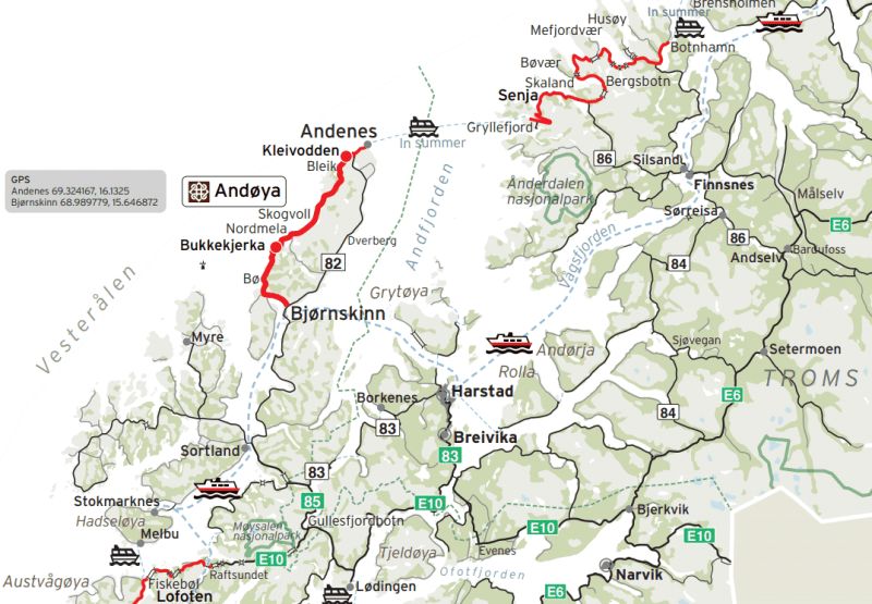
From Narvik we take another trip to Sweden, Abisko National Park
Abisko 1:22, 981 07 Abisko, Zweden
68° 20' 58.3" N 18° 49' 52.5" E
68.3495413 18.8312408
• Head toward Kalle Jons väg on Karvens väg. Go for 33 m.
• Turn slightly left onto Kalle Jons väg. Go for 133 m.
• Turn left onto E10. Go for 38.6 km.
• Continue on Kong Olavs vei (E10). Go for 27.4 km.
• Turn right onto Nygård (E6/E10) toward Alta/Å i Lofoten. Go for 6.3 km.
• Take the 1st exit from roundabout onto Leirvik (E6/E10) toward Alta. Go for 8.6 km.
• Take the 2nd exit from roundabout onto Kong Olavs vei (E10) toward Å i Lofoten/83/Harstad. Go for 1.0 km.
• Turn right onto Prestjordveien. Go for 264 m.
• Turn left onto Prestjordveien. Go for 55 m.
• Arrive at Prestjordveien. Your destination is on the right.
☍
82,4 km
(1 hrs. 10 min.)
Bjervik, Noorwegen
From here we enter the Lofoten
Prestjordveien 23, 8530 Bjerkvik, Noorwegen
68° 33' 14.2" N 17° 31' 52.8" E
68.5539529 17.5313250
• Head northeast on Prestjordveien. Go for 55 m.
• Turn right onto Prestjordveien. Go for 264 m.
• Turn right onto Kong Olavs vei (E10). Go for 59.5 km.
• Take the 2nd exit from roundabout onto Tjeldsundveien (E10) toward Sortland/Lødingen/Å i Lofoten. Go for 48.3 km.
• Turn right onto Kong Olavs vei (E10). Go for 18.1 km.
• Take the 2nd exit from roundabout onto Våtvollveien (85). Go for 14.4 km.
• Turn left onto Kong Olavs vei (85). Go for 14.3 km.
• Continue on Strandveien (85). Go for 4.6 km.
• Continue on Kringelveien (82). Go for 5.1 km.
• Continue on 82. Go for 430 m.
• Continue on Lilandveien (82). Go for 5.2 km.
• Continue on Reinsnesveien (82). Go for 14.5 km.
• Continue on 82. Go for 14.4 km.
• Continue on Buksnes (82). Go for 139 m.
• Continue on 82. Go for 1.5 km.
• Continue on Godbakken (82). Go for 96 m.
• Continue on 82. Go for 1.3 km.
• Continue on Toftar (82). Go for 102 m.
• Continue on 82. Go for 315 m.
• Continue on Alset (82). Go for 101 m.
• Continue on 82. Go for 14.7 km.
• Continue on Torvhågveien (82). Go for 181 m.
• Continue on 82. Go for 10.1 km.
• Continue on Dverbergveien (82). Go for 4.4 km.
• Continue on Sandmelra (82). Go for 94 m.
• Continue on 82. Go for 22.0 km.
• Continue on Bleiksveien (82). Go for 174 m.
• Continue on Bleiksveien (82). Go for 3.1 km.
• Continue on Storgata (82). Go for 433 m.
• Arrive at Storgata (82).
☍
258,1 km
(3 hrs. 55 min.)
Andenes, Noorwegen
Storgata 55, 8480 Andenes, Noorwegen
69° 18' 57.9" N 16° 7' 12.8" E
69.3160799 16.1202284
• Head toward Vesterveien on Storgata (82). Go for 433 m.
• Continue on Bleiksveien (82). Go for 3.3 km.
• Continue on 82. Go for 22.0 km.
• Continue on Sandmelra (82). Go for 94 m.
• Continue on Dverbergveien (82). Go for 4.4 km.
• Continue on 82. Go for 10.1 km.
• Continue on Torvhågveien (82). Go for 181 m.
• Continue on 82. Go for 14.7 km.
• Continue on Alset (82). Go for 101 m.
• Continue on 82. Go for 315 m.
• Continue on Toftar (82). Go for 102 m.
• Continue on 82. Go for 1.3 km.
• Continue on Godbakken (82). Go for 96 m.
• Continue on 82. Go for 1.5 km.
• Continue on Buksnes (82). Go for 139 m.
• Continue on 82. Go for 14.4 km.
• Continue on Reinsnesveien (82). Go for 14.5 km.
• Continue on Lilandveien (82). Go for 5.2 km.
• Continue on 82. Go for 430 m.
• Continue on Kringelveien (82). Go for 5.1 km.
• Continue on Strandveien (85). Go for 4.6 km.
• Continue on Kong Olavs vei (85). Go for 14.3 km.
• Turn right onto Våtvollveien (85). Go for 14.3 km.
• Take the 1st exit from roundabout onto E10. Go for 79.5 km.
• Take the 1st exit from roundabout onto Kong Olavs vei (E10). Go for 67.2 km.
• Pass 4 roundabouts and continue on Buksnesveien (E10). Go for 3.1 km.
• Turn right onto Flesveien (E10). Go for 57.3 km.
• Turn left onto Birger Eriksens vei (E10). Go for 360 m.
• Arrive at Birger Eriksens vei (E10).
☍
339,3 km
(5 hrs. 15 min.)
Moskenes, Noorwegen
see if we can take the drill to Bodo from here
Birger Eriksens Vei 23, 8392 Sørvågen, Noorwegen
67° 54' 0.7" N 13° 2' 47.5" E
67.9001872 13.0465365
• Head south on Birger Eriksens vei (E10). Go for 28 m.
• Turn right onto Birger Eriksens vei (E10). Go for 119 m.
• Take the Moskenes-Bodø Ferry. Stay on for 96.9 km.
• Head east on Terminalveien (80). Go for 271 m.
• Turn right onto Terminalveien (80). Go for 31 m.
• Turn right onto Terminalveien (80). Go for 27 m.
• Take the 1st exit from roundabout onto Jernbaneveien (80). Go for 487 m.
• Take the 2nd exit from roundabout onto Jernbaneveien (80). Go for 141 m.
• Take the 3rd exit from roundabout onto Sjøgata (80). Go for 591 m.
• Take the 2nd exit from roundabout onto 80. Go for 702 m.
• Take the 1st exit from roundabout onto Sandhorngata. Go for 144 m.
• Turn right onto Gamle Riksvei. Go for 13 m.
• Turn left onto Sandhorngata. Go for 389 m.
• Arrive at Sandhorngata. Your destination is on the right.
☍
99,8 km
(3 hrs. 2 min.)
Bodo, Noorwegen
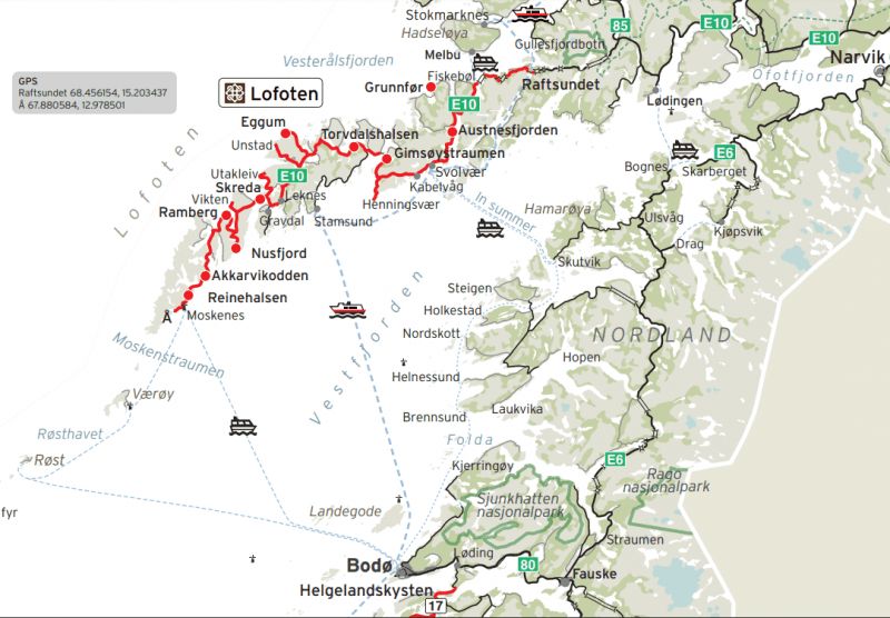
Saltstraumen by RIB
Come by and experience the bustling tidal current of Saltstraumen through RIB! We travel through a breathtaking landscape and you are in close contact with the elements. We will make several stops during the tour and you will learn about our proud coastal heritage.
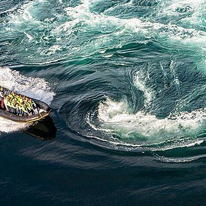
Mjelle Pure nature! Beautiful beach with beautiful blue water. The beach can be reached on foot after a nice walk.
Børtindgata 12, 8008 Bodø, Noorwegen
67° 16' 49.3" N 14° 24' 17.7" E
67.2803556 14.4049160
• Head southwest on Sandhorngata.
• Turn left onto Børtindgata. Go for 227 m.
• Turn left onto Hålogalandsgata. Go for 383 m.
• Take the 2nd exit from roundabout onto Hålogalandsgata. Go for 464 m.
• Take the 1st exit from roundabout. Go for 113 m.
• Take the 2nd exit from roundabout onto 80. Go for 488 m.
• Pass 4 roundabouts and continue on 80. Go for 15.5 km.
• Take the 1st exit from roundabout onto 17. Go for 13.3 km.
• Arrive at Saltstraumveien (17).
☍
30,5 km
( 29 min.)
Tuv, Noorwegen
6JF5+5R Tuv, Noorwegen
67° 13' 22.5" N 14° 36' 34.5" E
67.2229098 14.6095857
• Head toward Gjerdeveien on Saltstraumveien (17). Go for 839 m.
• Turn left onto Kulturveien (812). Go for 21.5 km.
• Arrive at Kulturveien (812).
☍
22,3 km
( 20 min.)
Me in Nature
Sandkollen 45, 8100 Misvær, Noorwegen
67° 12' 27.4" N 14° 56' 56.4" E
67.2076070 14.9490023
• Head south on Kulturveien (812). Go for 15.1 km.
• Turn left onto Nupveien (7484). Go for 507 m.
• Turn left. Go for 44 m.
• Turn slightly left toward Vei 1406. Go for 37 m.
• Continue on Vei 1406. Go for 40 m.
• Arrive at Vei 1406. Your destination is on the right.
☍
15,7 km
( 15 min.)
Misvær Camping Aksjeselskap
Address:8100 Misvær
Nettstedet:http://www.misvaercamping.no/?...
8100 Misvær, Noorwegen
67° 7' 22.4" N 15° 0' 14" E
67.1228864 15.0038910
• Head south on Vei 1406. Go for 117 m.
• Turn left toward Nupveien/7484. Go for 264 m.
• Turn right onto Nupveien (7484). Go for 403 m.
• Turn left onto Kulturveien (812). Go for 32.1 km.
• Turn right onto E6. Go for 2.6 km.
• Turn right onto 7466. Go for 1.6 km.
• Continue on Gropa (7466). Go for 50 m.
• Continue on 7466. Go for 619 m.
• Arrive at 7466. Your destination is on the right.
☍
37,7 km
( 35 min.)
Nesby, Noorwegen
399P+35 Nesby, Noorwegen
67° 4' 3.5" N 15° 23' 7.6" E
67.0676479 15.3854448
• Head toward Oseng on 7466. Go for 4.4 km.
• Turn right onto 7466. Go for 790 m.
• Turn left onto 7466. Go for 117 m.
• Turn left onto E6. Go for 138 km.
• Take the 2nd exit from roundabout onto Selforsveien (E6) toward Mo i Rana. Go for 265 m.
• Take the 2nd exit from roundabout onto Selforsveien (E6). Go for 257 m.
• Take the 1st exit from roundabout onto Nesnaveien (12) toward 17/Utskarpen. Go for 774 m.
• Take the 1st exit from roundabout onto Nesnaveien (12) toward Kysten. Go for 394 m.
• Take the 2nd exit from roundabout onto Nesnaveien (12). Go for 1.4 km.
• Turn right onto Grannesveien. Go for 29 m.
• Continue on Grannesveien. Go for 127 m.
• Turn right onto Loftfjellveien. Go for 428 m.
• Turn right. Go for 1.5 km.
• Arrive at your destination.
☍
148,0 km
(1 hrs. 51 min.)
Mo i Rana, Noorwegen
Mo i Rana (Norwegian pronunciation: [ˈmuː i ˈrɑːnɑ]) is a town and administrative center of Rana Municipality in Nordland County, Norway. It is located just south of the Arctic Circle and in the Helgeland region of Nordland. Some of the outlying areas of the city include the suburbs of Båsmoen and Ytteren to the north and Selfors to the east.
9559+53 Mo i Rana, Noorwegen
66° 21' 28.4" N 14° 10' 3.5" E
66.3578827 14.1676304
• Head toward Loftfjellveien. Go for 1.5 km.
• Turn left onto Loftfjellveien. Go for 428 m.
• Turn left onto Grannesveien. Go for 156 m.
• Turn left onto Nesnaveien (12). Go for 1.3 km.
• Take the 2nd exit from roundabout onto Nesnaveien (12). Go for 436 m.
• Take the 1st exit from roundabout onto Vikaåsen toward Sentrum. Go for 847 m.
• Take the 2nd exit from roundabout onto Vikaåsen. Go for 877 m.
• Take the 1st exit from roundabout onto Midtre gate. Go for 168 m.
• Turn left onto Midtre gate. Go for 694 m.
• Continue on Søndre gate. Go for 322 m.
• Turn right onto Søndre gate. Go for 119 m.
• Arrive at your destination.
☍
6,8 km
( 13 min.)
Havmannen
Havmannen stands in the water of the Ranfjord about 15 meters from the water's edge. The water surface rises and falls with the tide. The position of the image is also determined by its relationship with the structure of the city.
The statue stands with its back to the city, looking out over the fjord, towards the open sea. It seems to focus on its own thoughts, turning inward to its inner space, both as a physical and a mental state. Despite its scale, this statue is not a monument. The rhetoric is addressed to each of us individually, and this discussion is private. It belongs to the experiences that we cannot share with others. We base our sense of having something in common on the belief that we share these existential experiences.
If we go a step further and look at the sculpture in its surroundings, in the landscape formed by the city and its buildings, the fjord with its water and the hills with their intricate stone formations, we can experience that the sculpture loses its materially heavy presence and is transformed into a black outline, almost a hole or negative shape sculpted in the sky.
Ola Grotnes' vei, 8624 Mo i Rana, Noorwegen
66° 18' 36.6" N 14° 7' 38.6" E
66.3101729 14.1273880
• Head west.
• Turn left toward Søndre gate. Go for 206 m.
• Turn right onto Søndre gate. Go for 77 m.
• Turn left onto Mobekkbrua. Go for 242 m.
• Take the 2nd exit from roundabout onto E6. Go for 81 m.
• Take the 1st exit from roundabout onto E6 toward Trondheim. Go for 22.7 km.
• Turn right toward Dalavegen. Go for 195 m.
• Turn left onto Dalavegen. Go for 64 m.
• Turn left onto Tuvslettvegen. Go for 111 m.
• Turn left. Go for 205 m.
• Arrive at your destination.
☍
23,9 km
( 22 min.)
Finneidfjord, Noorwegen
Finneidfjord is a place in Hemnes Municipality, Nordland County, Norway. Finneidfjord has 389 inhabitants and has an area of 0.6 km²
5RRH+C5 Finneidfjord, Noorwegen
66° 11' 28" N 13° 49' 40.6" E
66.1911024 13.8279527
• Head toward Tuvslettvegen. Go for 205 m.
• Turn right onto Tuvslettvegen. Go for 111 m.
• Turn right onto Dalavegen. Go for 64 m.
• Turn right toward E6. Go for 195 m.
• Turn right onto E6. Go for 15.0 km.
• Turn left onto Parkveien (806/321). Go for 149 m.
• Turn left onto Parkveien (7350). Go for 168 m.
• Turn right onto Sentrumsveien. Go for 91 m.
• Arrive at Sentrumsveien. Your destination is on the right.
☍
16,0 km
( 14 min.)
Hemnes kommune
Nature and geology De
Hemnes municipality has a varied nature. The river Røssåga flows through a valley in a south-north direction from Tustervatnet, the northwestern arm of Røssvatn, to Sørfjorden. The valley is open and wide and has good farmland. The forest line runs at 400-500 meters above sea level. More than half of the area of the municipality is above this level and only six percent of the municipality is below 150 meters above sea level. This level largely coincides with the cultivation limit.
At the top of Bryggfjelldalen, a side valley to the Røssågas Valley to the east, lies the 2.1-kilometer-long Grønndal Cave and Ytterlihullet, one of Norway's deepest caves, 180 meters deep.
The rock in Hemnes is strongly influenced by the Caledonian mountain range folding (Caledonian orogeny). Large areas in the municipality are covered with mica shale and mica gneiss, as well as Precambrian and Cambrosilur rocks that have been heavily modified during the folding of the mountain range. North of Røssvatnet, in the southern part of the municipality, is Okstindan with Oksskolten, the highest mountain in Northern Norway with 1916 meters above sea level. A significant portion of the mountain range is covered by the Okstind Glacier.
Magmatic rocks, mainly granite, have invaded the transformed rocks in some places north of the municipality, for example in the central parts of the Hemnes peninsula and in a few smaller areas west of Skarpsundet, at the inlet to the southern arms of the Ranfjord , Sørfjorden and Elsfjorden . Otherwise, the folding chain in Hemnes has different areas with limestone and marble, for example in the northeast, south
Sentrumsveien 1, 8646 Korgen, Noorwegen
66° 4' 35.9" N 13° 49' 24.8" E
66.0766286 13.8235474
• Head toward Nordfallet on Sentrumsveien. Go for 91 m.
• Turn left onto Parkveien (7350). Go for 168 m.
• Continue on Parkveien (806). Go for 386 m.
• Continue on Sjøforsen (806). Go for 785 m.
• Continue on 806. Go for 683 m.
• Continue on Sjøsela (806). Go for 101 m.
• Continue on 806. Go for 419 m.
• Continue on Reinåneset (806). Go for 76 m.
• Continue on 806. Go for 458 m.
• Continue on Sagen (806). Go for 58 m.
• Continue on 806. Go for 2.5 km.
• Continue on Granengmoen (806). Go for 56 m.
• Continue on 806. Go for 600 m.
• Continue on Sørfjellveien (806). Go for 275 m.
• Continue on 806. Go for 248 m.
• Continue on Bjuråmoen (806). Go for 97 m.
• Continue on 806. Go for 2.1 km.
• Turn slightly left onto Skoglund (806). Go for 130 m.
• Continue on 806. Go for 1.2 km.
• Continue on Heggedal (806). Go for 99 m.
• Continue on 806. Go for 4.1 km.
• Continue on Ivarrud (806). Go for 98 m.
• Continue on 806. Go for 255 m.
• Continue on Sørfjellveien (806). Go for 704 m.
• Continue on 806. Go for 6.2 km.
• Continue on Sørfjellveien (806). Go for 441 m.
• Continue on 806. Go for 85 m.
• Continue on Kongsdalsveien (7356). Go for 148 m.
• Arrive at Kongsdalsveien (7356).
☍
22,5 km
( 32 min.)
Bleikvasslia, Noorwegen
Here we go into the Okstidan nature reserve, also called the roof of Norway, but we still have to find out whether it is good to drive with the camper
WR45+HQ Bleikvasslia, Noorwegen
65° 54' 23.2" N 13° 48' 33.9" E
65.9064460 13.8094218
• Head toward Langliveien on Kongsdalsveien (7356). Go for 148 m.
• Turn left onto Åsli (7340). Go for 116 m.
• Continue on 7340. Go for 4.4 km.
• Continue on Tuven (7340). Go for 98 m.
• Continue on 7340. Go for 16.5 km.
• Continue on Villmarksveien (7340). Go for 7.7 km.
• Arrive at Villmarksveien (7340). Your destination is on the right.
☍
29,0 km
( 40 min.)
Aakerviken, Noorwegen
Okstindan is a mountain range in the inner Helgeland district in Nordland county, Norway. It is located in the municipality of Hemnes. Mount Oksskolten is part of the Okstindan Mountains and is the highest mountain in Northern Norway.
PXC5+JQ Aakerviken, Noorwegen
65° 43' 17.5" N 13° 57' 34.1" E
65.7215266 13.9594676
• Head south on Villmarksveien (7340). Go for 12.5 km.
• Continue on 7340. Go for 9 m.
• Continue on Villmarksveien (7340). Go for 7.1 km.
• Turn right onto Hattfjelldalsveien (73). Go for 1.5 km.
• Arrive at Hattfjelldalsveien (73).
☍
21,1 km
( 28 min.)
Mjølkarlia, Noorwegen
HWX8+RG Mjølkarlia, Noorwegen
65° 35' 58.6" N 13° 54' 58.6" E
65.5996099 13.9162711
• Head southwest on Hattfjelldalsveien (73). Go for 29.1 km.
• Turn right and take ramp toward Steinkjer/Mosjøen. Go for 126 m.
• Turn left onto E6. Go for 17.9 km.
• Arrive at Svenningdalsvegen (E6). Your destination is on the right.
☍
47,0 km
( 35 min.)
Wild Campingspot
Langveien, 8680 Trofors, Noorwegen
65° 23' 2.9" N 13° 21' 57.9" E
65.3841462 13.3660698
• Head south on Svenningdalsvegen (E6). Go for 929 m.
• Turn right onto Tosenvegen (76) toward Brønnøysund. Go for 65.1 km.
• Arrive at Tosenveien (76).
☍
66,0 km
( 53 min.)
Hommelstø, Noorwegen
CG2V+HX Hommelstø, Noorwegen
65° 24' 5.3" N 12° 32' 41.7" E
65.4014635 12.5449144
• Head northwest on Tosenveien (76). Go for 22.4 km.
• Turn right onto Skille (17). Go for 947 m.
• Turn right onto Eideveien. Go for 1.4 km.
• Turn slightly right. Go for 432 m.
• Arrive at your destination on the right.
☍
25,2 km
( 24 min.)
Kjerringlorten Leirduebane
8900 Brønnøysund, Noorwegen
65° 30' 20" N 12° 22' 28.4" E
65.5055618 12.3745537
• Head toward Eideveien. Go for 432 m.
• Turn slightly left onto Eideveien. Go for 1.4 km.
• Turn left onto Skille (17). Go for 36.3 km.
• Turn right. Go for 113 m.
• Arrive at your destination.
☍
38,2 km
( 34 min.)
Vendesund, Noorwegen
VENNESUND CAMPING KYSTVEIEN 5 8920 SOMNA
0047 7502 7375
N65°12'55" E12°2'33"
CAMPSITE SIZE: 2 HA
OPEN: 01-01-2021 - 31-12-2021
Vennesund Campsite in Somna in the Nordland region
Since 2018 Vennesund Camping has had a new sanitary building with, among other things, large family bathrooms. In addition, the hytter has been renovated and, in addition to the "grass camping pitches", a number of paved places (with extra power connections) have also been realised. Handy in bad weather. The campsite has free WIFI and the restaurant (Brygge) at the campsite is very popular. From the terrace at the restaurant you have a wonderful view of the sea and the ferries.
64R7+82 Vendesund, Noorwegen
65° 14' 27.1" N 12° 6' 45" E
65.2408529 12.1125084
• Head south. Go for 113 m.
• Turn right onto 17. Go for 4.9 km.
• Take the Vennesund-Holm Ferry. Stay on for 5.6 km.
• Head north on Holmsveien (17). Go for 257 m.
• Arrive at Holmsveien (17).
☍
10,9 km
( 43 min.)
Holm, Norway, Noorwegen
54J9+X8 Holm, Norway, Noorwegen
65° 10' 56.8" N 12° 7' 5.8" E
65.1824437 12.1182722
• Head east on Holmsveien (17). Go for 20.4 km.
• Turn right onto Hollupveien (802) toward Bogen/Leka Ferge. Go for 5.7 km.
• Turn right onto Gravvikvegen (771). Go for 28 m.
• Continue on 771. Go for 38 m.
• Continue on Horsfjordveien (771). Go for 3.9 km.
• Turn left onto Horsfjordveien. Go for 108 m.
• Arrive at Horsfjordveien.
☍
30,1 km
( 24 min.)
Sørhorsfjord, Noorwegen
4222+GX Sørhorsfjord, Noorwegen
65° 6' 4.5" N 12° 0' 8.7" E
65.1012589 12.0024031
• Head south on Horsfjordveien. Go for 108 m.
• Turn right onto Horsfjordveien (771). Go for 3.9 km.
• Continue on 771. Go for 38 m.
• Continue on Gravvikvegen (771). Go for 28 m.
• Turn left onto Hålopvegen (802). Go for 5.7 km.
• Turn right onto Årsandøyveien (17). Go for 20.5 km.
• Turn left onto Foldavegen (17) toward Steinkjer/Namsos. Go for 80.4 km.
• Take the 2nd exit from roundabout onto Overhallsvegen (17). Go for 22.4 km.
• Turn left onto Spillumsstrandsvegen (17). Go for 1.9 km.
• Take the 2nd exit from roundabout onto Spillumsstrandsvegen (17) toward Steinkjer. Go for 1.5 km.
• Take the 1st exit from roundabout onto Nøsthaugvegen (769). Go for 1.2 km.
• Turn left onto Sivavegen. Go for 248 m.
• Turn left onto Sivavegen. Go for 415 m.
• Arrive at Sivavegen.
☍
138,3 km
(2 hrs. 1 min.)
Namsos, Noorwegen
FG46+JP Namsos, Noorwegen
64° 27' 23.5" N 11° 30' 42.4" E
64.4565167 11.5117656
• Head northeast on Sivavegen. Go for 415 m.
• Turn right onto Sivavegen. Go for 248 m.
• Turn right onto Nøsthaugvegen (769). Go for 1.1 km.
• Take the 2nd exit from roundabout onto Veg Nr 26 (17). Go for 23.0 km.
• Turn left. Go for 109 m.
• Arrive at your destination.
☍
24,9 km
( 23 min.)
Sjøåsen, Noorwegen
865Q+MV Sjøåsen, Noorwegen
64° 18' 33.2" N 11° 14' 22.9" E
64.3092096 11.2397010
• Head toward Namsosvegen. Go for 255 m.
• Turn left onto Namsosvegen (17). Go for 40.0 km.
• Turn right onto Kvamsvegen (E6). Go for 5.3 km.
• Pass 7 roundabouts and continue on Steinkjervegen (E6). Go for 8.9 km.
• Keep left onto E6 toward Trondheim. Go for 29.6 km.
• Pass 3 roundabouts and continue on E6. Go for 28.0 km.
• Take the 1st exit from roundabout onto Breivegen (E6). Go for 9.8 km.
• Pass 6 roundabouts and continue on E6. Go for 40.5 km.
• Take ramp onto Haakon VII's gate (6668) toward Lade. Go for 1.2 km.
• Pass 2 roundabouts and continue on Haakon VII's gate (6668). Go for 1.8 km.
• Take the 3rd exit from roundabout onto Lade alle (6668). Go for 209 m.
• Turn right onto Olav Engelbrektssons alle. Go for 496 m.
• Turn left onto Sjømannsveien. Go for 270 m.
• Turn slightly right onto Leiv Eirikssons vei. Go for 776 m.
• Arrive at Leiv Eirikssons vei.
☍
167,2 km
(2 hrs. 29 min.)
Trondheim, Noorwegen
FF83+28 Trondheim, Noorwegen
63° 27' 54" N 10° 27' 12.1" E
63.4650066 10.4533571
• Head southwest on Leiv Eirikssons vei. Go for 776 m.
• Turn slightly left onto Sjømannsveien. Go for 270 m.
• Turn right onto Olav Engelbrektssons alle. Go for 496 m.
• Turn left onto Lade alle (6668). Go for 171 m.
• Take the 1st exit from roundabout onto Haakon VII's gate (6668). Go for 1.3 km.
• Pass 3 roundabouts. Go for 1.8 km.
• Take ramp onto Omkjøringsvegen (E6) toward Oslo. Go for 5.4 km.
• Keep left onto Omkjøringsvegen (E6) toward E39/Oslo/Heimdal. Go for 3.1 km.
• Keep left onto E6 toward Oslo/E39. Go for 79.0 km.
• Keep left onto Trondheimsveien (E6). Go for 31.4 km.
• Pass 3 roundabouts and continue on E6. Go for 48.2 km.
• Turn right onto Hjerkinnhusvegen. Go for 158 m.
• Turn slightly left. Go for 76 m.
• Arrive at your destination on the right.
☍
172,1 km
(2 hrs. 27 min.)
Hjerkinn, nabij National park Dovrefjell, Noorwegen
Musk Ox safari.
Look for the last herd of wild musk oxen in Dovrefjell National Park. Musk oxen live in groups on the open tundra plains of northern Siberia, Greenland, Canada, Alaska and also Norway.
Musk oxen are arctic animals and are mainly found in cold regions, but they have been reintroduced in certain northern areas, such as Russia, Alaska, Spitsbergen and the Dovrefjell National Park in Norway. This Dovrefjell National Park is therefore one of the few places in the world where the musk ox still alive in the wild
Hjerkinnhusvegen 14, 2661 Hjerkinn, Noorwegen
62° 13' 15.2" N 9° 32' 57.7" E
62.2208792 9.5493603
• Head toward Hjerkinnhusvegen. Go for 76 m.
• Turn slightly right onto Hjerkinnhusvegen. Go for 158 m.
• Turn right onto Trondheimsvegen (E6). Go for 30.9 km.
• Take the 1st exit from roundabout onto Romsdalsvegen (E136) toward Ålesund/Åndalsnes. Go for 55.4 km.
• Take the 3rd exit from roundabout onto Romsdalsvegen (E136). Go for 49.0 km.
• Turn left onto Sørsidevegen (E136) toward Ålesund. Go for 43.4 km.
• Take the 2nd exit from roundabout onto Brastadstranda (E39) toward Ålesund. Go for 21.5 km.
• Turn left onto Giskemovegen (522). Go for 176 m.
• Continue on Valgermo (522). Go for 97 m.
• Continue on Giskemovegen (522). Go for 142 m.
• Continue on 522. Go for 43 m.
• Continue on Giskemovegen (522). Go for 1.0 km.
• Turn left onto Storfjordvegen (650). Go for 38.7 km.
• Turn right onto 63. Go for 156 m.
• Take the Linge-Eidsdal Ferry. Stay on for 2.6 km.
• Head toward Ytterdalsgata on 63. Go for 11.8 km.
• Turn right onto Indreeidstunnelen (63). Go for 5.2 km.
• Turn right onto Ørnevegen (63). Go for 9.6 km.
• Turn left. Go for 26 m.
• Arrive at your destination on the left.
☍
270,0 km
(4 hrs. 31 min.)
Vinje camping Geiranger, Noorwegen
The Geirangerfjord is 'just' a 15 kilometer long arm of the enormous Storfjord. But it is one of the most impressive you can find in the Norwegian fjords. I will explore it by car, on foot and by ferry. these are the most beautiful sights of the Geirangerfjord.
This fjord is home to many waterfalls. All waterfalls have been given names. And they are all easy to see from the water. A boat trip is therefore the most suitable for this.
Geirangerfjord Viewpoint
When you arrive driving to the village of Geiranger the road meanders from top to bottom. At the top you can see a lookout called Ørnesvingen. From here you have a nice overview of the first part of the fjord. Which is also the narrowest. Perfect for a photo. With a bit of luck you will see a ferry and only then you will see how immense the gorge is. And how small the ship.
Geirangervegen 146, 6216 Geiranger, Noorwegen
62° 5' 42.2" N 7° 13' 5.9" E
62.0950660 7.2183190
• Head south. Go for 26 m.
• Turn right onto Geirangervegen (63). Go for 1.6 km.
• Turn left onto 63. Go for 119 m.
• Take the Geiranger-Hellesylt Ferry. Stay on for 20.1 km.
• Head toward Hellesyltvegen on 60. Go for 578 m.
• Turn right onto Hellesyltvegen (60). Go for 878 m.
• Turn left onto Langedalsvegen (60). Go for 25.0 km.
• Turn left onto E39 toward Bergen/Stryn/60. Go for 8.3 km.
• Turn left onto Nordfjordvegen (15) toward Stryn. Go for 15.8 km.
• Take the 2nd exit from roundabout onto Tonningsgata (15) toward Otta. Go for 124 km.
• Take the 1st exit from roundabout onto Sognefjellsvegen (55) toward Sogndal. Go for 998 m.
• Turn left toward Øy. Go for 68 m.
• Continue on Øy. Go for 43 m.
• Arrive at Øy.
☍
197,3 km
(3 hrs. 40 min.)
Lom, Noorwegen
climatic park 2469
OPNINGTIDER
Dayleg guiding: mid-June – mid-August: Klokka 10.30 and 14.00. Besøksadresse: Klimapark 2469, Galdhøpiggvegen 1357, 2687 Bøverdalen
There is also a bus from Lom going here
RHH5+VX Lom, Noorwegen
61° 49' 47" N 8° 33' 35.9" E
61.8297305 8.5599592
• Head toward Sognefjellsvegen on Øy. Go for 111 m.
• Turn right onto Sognefjellsvegen (55). Go for 986 m.
• Take the 1st exit from roundabout onto Bergomsvegen (15). Go for 24.7 km.
• Turn right onto Fjellvegen (51). Go for 92.2 km.
• Turn right onto Skøltevegen (2508). Go for 4.2 km.
• Continue on Dalsvegen (2508). Go for 2.9 km.
• Continue on Holun (2508). Go for 83 m.
• Continue on Dalsvegen (2508). Go for 741 m.
• Continue on Skjel (2508). Go for 85 m.
• Continue on Dalsvegen (2508). Go for 319 m.
• Continue on Ranisete (2508). Go for 141 m.
• Continue on Dalsvegen (2508). Go for 926 m.
• Continue on 2508. Go for 358 m.
• Continue on Eggeåsvegen (2508). Go for 5.4 km.
• Turn right onto Øygarden (2510). Go for 99 m.
• Continue on Ellestadvegen (2510). Go for 19 m.
• Continue on Hørevegen (2510). Go for 2.1 km.
• Turn left onto Riddarvegen (2510). Go for 2.3 km.
• Turn right onto Tyinvegen (E16). Go for 66.7 km.
• Take the 1st exit from roundabout onto E16 toward Bergen/Lærdal. Go for 28.3 km.
• Take the 2nd exit from roundabout onto E16 toward Bergen/Aurland. Go for 25.1 km.
• Pass 5 roundabouts and continue on Strandavegen (E16). Go for 72.2 km.
• Take the 1st exit from roundabout onto E16 toward Bergen. Go for 2.6 km.
• Pass 2 roundabouts and continue on Hardangervegen (E16). Go for 75.4 km.
• Take the 2nd exit from roundabout onto Hardangervegen (587) toward Flesland/Bergen Syd/E39. Go for 5.1 km.
• Turn right onto Lonaleitet (5294). Go for 81 m.
• Turn left onto Lonaleitet (5294). Go for 116 m.
• Turn left onto Lonaleitet. Go for 163 m.
• Continue on Kalihaugen. Go for 254 m.
• Turn left onto Hardangervegen. Go for 38 m.
• Turn left onto Hardangervegen (587). Go for 426 m.
• Turn right onto Hardangervegen. Go for 61 m.
• Continue on Hardangervegen. Go for 41 m.
• Turn slightly left onto Hardangervegen. Go for 16 m.
• Turn slightly right onto Lone Camping. Go for 133 m.
• Turn slightly left toward Hardangervegen. Go for 53 m.
• Turn left onto Hardangervegen. Go for 83 m.
• Arrive at Hardangervegen. Your destination is on the left.
☍
414,5 km
(5 hrs. 41 min.)
Bergen, Noorwegen
›
Lone Camping Bergen in Haukeland near Bergen in the Vestland region (Hordaland) Lone Camping Bergen is a large campsite with a wide variety of camping pitches. Due to the weather, the many paved camping pitches and the large number of accommodations are no superfluous luxury. Prefer on the grass? Which can. You are also directly on the Haukelandmeer. The various terraces on the campsite give you a nice view of the surrounding mountains and the lake.
Visit Bergen
Bus stop is in front of the campsite. Halfway through Nesttun, change to the express tram (Skyss) to Bergen. Times and information about the Bergen Card (including a discount on public transport and museums) are available at the reception. In Bergen, the fish market, the Floibanen and Bryggen are the biggest attractions. A little less weather? No problem. In the many restaurants, shops and shopping centers you can forget about bad weather.
At Lone Camping Mountains
You will find good sanitary facilities at the campsite. Also with nice family bathrooms (shower, toilet and sink in 1 room). Just in front of the campsite you will find a gas station and a large supermarket. You can do your shopping on foot. Or score a warm bite at the gas station. They also sell sandwiches at the gas station. In bad weather you can take them to the TV room at the campsite.
Lone Camping AS, Hardangervegen 697, 5268 Haukeland, Noorwegen
60° 22' 24.8" N 5° 27' 33.1" E
60.3735431 5.4592000
• Head south on Hardangervegen. Go for 83 m.
• Turn right. Go for 53 m.
• Turn slightly right toward Lone Camping. Go for 65 m.
• Continue on Lone Camping. Go for 68 m.
• Turn slightly left onto Hardangervegen. Go for 16 m.
• Turn slightly right onto Hardangervegen. Go for 41 m.
• Continue on Hardangervegen. Go for 43 m.
• Turn slightly left onto Hardangervegen. Go for 18 m.
• Turn right onto Hardangervegen (587). Go for 5.2 km.
• Take the 1st exit from roundabout onto Hardangervegen (E16) toward E39/Åsane/Indre Arna. Go for 9.7 km.
• Pass 2 roundabouts and continue on E16. Go for 68.3 km.
• Take the 2nd exit from roundabout onto Strandavegen (E16). Go for 1.2 km.
• Pass 4 roundabouts and continue on Vinjadalen (E16). Go for 62.0 km.
• Turn right onto Flåmsdalsvegen (5624). Go for 189 m.
• Continue on Flåmsdalsvegen. Go for 131 m.
• Turn left onto Nedre Fretheim. Go for 658 m.
• Turn right onto Fretheimshaugane. Go for 20 m.
• Turn slightly left onto Fretheimshaugane. Go for 15 m.
• Turn right. Go for 84 m.
• Arrive at your destination on the right.
☍
147,9 km
(2 hrs. 5 min.)
Flam, Noorwegen
Fretheimshaugane 84, 5743 Flåm, Noorwegen
60° 51' 38.8" N 7° 6' 42.4" E
60.8607716 7.1117849
• Head toward Fretheimshaugane. Go for 84 m.
• Turn left onto Fretheimshaugane. Go for 35 m.
• Turn left onto Nedre Fretheim. Go for 658 m.
• Turn right onto Flåmsdalsvegen. Go for 320 m.
• Turn left onto E16. Go for 44.2 km.
• Pass 5 roundabouts and continue on Strandavegen (E16). Go for 19.5 km.
• Continue on 13. Go for 874 m.
• Turn left onto Hardangervegen (13). Go for 30.3 km.
• Take the 1st exit from roundabout onto Vallaviktunnelen (13). Go for 3.3 km.
• Take the 2nd exit from Butunnelen roundabout onto Butunnelen (13). Go for 53.8 km.
• Turn left onto Ragdevegen. Go for 22 m.
• Turn right onto Ragdevegen. Go for 1.7 km.
• Arrive at Ragdevegen.
☍
154,8 km
(2 hrs. 26 min.)
Odda, Noorwegen
3H7J+9G Odda, Noorwegen
60° 3' 48.5" N 6° 34' 52.6" E
60.0634816 6.5812654
• Head south on Ragdevegen. Go for 1.7 km.
• Turn left onto Ragdevegen. Go for 22 m.
• Turn right onto Tyssedalsvegen (13). Go for 5.3 km.
• Arrive at Stanavegen (13). Your destination is on the right.
☍
7,0 km
( 10 min.)
Tyssendal, Trolltunga Noorwegen
Make sure you are fit enough
The hike to Trolltunga is really often underestimated. Not only in the heaviness of the walk, but also in clothing. First, it is not a walk through the park . You have to take into account a walk that will take you about 8 to 10 hours (round trip). If you stop a lot to take pictures and have lunch, it will take you longer. If you are not fit, do not start the walk.
Wear hiking clothes
Sunny and nice weather was predicted for us, we even waited for it. However, the weather above turned to rain and light snow. Wearing good hiking clothes is a must. Rain-resistant clothing certainly can't hurt either. I also recommend wearing layers so that you can put on and take off something. A pair of gloves is therefore not superfluous.
This is how you get to the Trolltunga start
By car
You can leave your car at three parking spaces. The Trolltunga hike starts at P2 or P3.
- In the village of Tyssedal (also called P1: 220 parking spaces). P1 costs NOK 300 (about €30) per day. + shuttle costs to P3
- At the bottom of the trail at Skjeggedal (P2: 180 places). P2 costs NOK 500 (about €50) per day
- 1 kilometer after the official start of the walk, at the upper parking or Mågelitopp (P3: 30 places). P3 costs NOK 600 (about €60) per day. .
By shuttle bus
Due to the limited parking capacity, it is recommended to come by public transport. You can take public transport from the town of Odda or Tyssedal to P2 or P3.
There are two companies that arrange shuttle buses between Odda, P1 Tyssedal and P2 Skjeggedal: Odda Taxi (OT) and TaxiBus Odda (TBO). These run in the season from June 1 to September 30. The price from Odda to P2 Skjeggedal is NOK 230–250 (return ticket)
Skjeggedalsvegen 15, 5770 Tyssedal, Noorwegen
60° 7' 0.3" N 6° 33' 35.1" E
60.1167612 6.5597398
• Head northwest on Stanavegen (13).
• Turn left onto Gamle Oddaveg. Go for 49 m.
• Take the 3rd exit from roundabout onto Gamle Oddaveg. Go for 110 m.
• Turn right onto Stanavegen (13). Go for 6.2 km.
• Take the 2nd exit from roundabout onto Røldalsvegen (13). Go for 17.7 km.
• Turn left onto E134 toward Haukeli/Rødal. Go for 20.0 km.
• Turn right onto Suldalsvegen (13) toward Sandnes/Sand. Go for 58.7 km.
• Turn left onto Gullingvegen (4702) toward Jøsenfjorden/Mosvatnet. Go for 736 m.
• Turn right onto Gullingvegen (4702). Go for 16.8 km.
• Continue on Jøsenfjordvegen (4702). Go for 11.2 km.
• Turn left onto Indre Ryfylkevegen (13). Go for 13.1 km.
• Take the Nesvik-Hjelmeland Ferry. Stay on for 3.1 km.
• Head southeast on 13. Go for 241 m.
• Take the 1st exit from roundabout onto Ryfylkevegen (13). Go for 43.8 km.
• Take the 3rd exit from roundabout onto Ryfylkevegen (13) toward Sandnes/Jørpeland. Go for 3.5 km.
• Pass 4 roundabouts and continue on Ryfylkevegen (523). Go for 11.0 km.
• Turn left onto Preikestolvegen (4642). Go for 87 m.
• Turn left onto Preikestolvegen (4642). Go for 24 m.
• Turn right onto Preikestolvegen (4642). Go for 834 m.
• Turn right onto Preikestolvegen. Go for 64 m.
• Turn left onto Preikestolvegen. Go for 41 m.
• Arrive at Preikestolvegen. Your destination is on the left.
☍
207,3 km
(4 hrs. 7 min.)
Preikestolen, Noorwegen
Preikestolvegen 97, 4100 Jørpeland, Noorwegen
58° 59' 56" N 6° 5' 32.9" E
58.9989005 6.0924644
• Head east on Preikestolvegen. Go for 80 m.
• Turn left onto Preikestolvegen. Go for 113 m.
• Turn right onto Preikestolvegen. Go for 19 m.
• Turn left onto Preikestolvegen (4642). Go for 834 m.
• Turn left onto Preikestolvegen (4642). Go for 85 m.
• Turn right onto Ryfylkevegen (523). Go for 3.7 km.
• Pass 3 roundabouts and continue on Ryfylkevegen (13). Go for 7.3 km.
• Take the 2nd exit from roundabout onto 13. Go for 15.0 km.
• Take the 2nd exit from roundabout onto Hundvågtunnelen (13). Go for 6.0 km.
• Continue on E39 (Eiganestunnelen). Go for 25.7 km.
• Pass 3 roundabouts and continue on Sandnesveien (E39). Go for 127 km.
• Turn right onto E39. Go for 7.9 km.
• Pass 7 roundabouts and continue on E39. Go for 35.6 km.
• Take the 2nd exit from roundabout onto E39 toward Kristiansand. Go for 28.1 km.
• Take the 2nd exit from roundabout onto Fidjebakken (E39). Go for 1.9 km.
• Keep left onto Vesterveien (E18) toward Oslo/Sentrum/Sykehus. Go for 102 km.
• Take the 2nd exit from roundabout onto Lindlandsveien (E18). Go for 61.0 km.
• Take ramp toward Heistad. Go for 189 m.
• Take the 2nd exit from roundabout. Go for 379 m.
• Take the 1st exit from roundabout. Go for 166 m.
• Continue on E18. Go for 124 km.
• Keep right toward Fosskolltunnelen. Go for 217 m.
• Continue on Fosskolltunnelen. Go for 540 m.
• Continue toward E18. Go for 163 m.
• Continue on E18. Go for 32.6 km.
• Take ramp toward DFDS/Stena/Sentralst. Go for 531 m.
• Turn right onto Myntgata toward Ring 1. Go for 66 m.
• Turn left onto Langkaia toward Ring 1. Go for 183 m.
• Continue on Langkaia. Go for 133 m.
• Turn right onto Operagata toward Ring 1. Go for 316 m.
• Turn left onto Nylandsveien. Go for 514 m.
• Take the 3rd exit from roundabout toward Sentrum V. Go for 205 m.
• Take the 1st exit from roundabout onto Schweigaards gate (162) toward Ring 1/Sentrum V. Go for 105 m.
• Take the 2nd exit from roundabout onto Lybekkergata (162). Go for 254 m.
• Continue on Hammersborggata (162). Go for 114 m.
• Turn left onto Calmeyers gate. Go for 66 m.
• Turn right onto Youngs gate. Go for 155 m.
• Turn left onto Møllergata. Go for 126 m.
• Arrive at Møllergata. Your destination is on the left.
☍
582,3 km
(7 hrs. 20 min.)
Oslo Noorwegen
Not yet known whether we will visit Oslo, but above Oslo we will go back into Sweden
Møllergata 12, 0179 Oslo, Noorwegen
59° 54' 52.5" N 10° 44' 50.6" E
59.9145842 10.7473764
• Head toward Skråninga on Møllergata. Go for 306 m.
• Continue on Kongens gate. Go for 500 m.
• Turn left onto Myntgata. Go for 276 m.
• Continue on Myntgata. Go for 98 m.
• Turn right toward E18/Stockholm/E6. Go for 85 m.
• Continue on Akershusstranda toward E18/Stockholm/E6/Trondheim/Gøteborg/Akershus Slott. Go for 194 m.
• Take the 1st exit from roundabout onto Operatunnelen (E18) toward Stockholm/E6/Trondheim/Gøteborg. Go for 1.2 km.
• Keep right onto Operatunnelen (E18) toward Stockholm/Gøteborg/E6/Ring 1/Sentrum Ø. Go for 17.9 km.
• Take ramp onto E6/E18. Go for 820 m.
• Continue on E6 toward Gøteborg. Go for 91.5 km.
• Continue on E6 (Svinesundsbron). Go for 78.0 km.
• Take exit 100 toward Håby. Go for 794 m.
• Take the 2nd exit from roundabout onto Håbyvägen. Go for 281 m.
• Take the 1st exit from roundabout. Go for 2.5 km.
• Take the 3rd exit from roundabout. Go for 401 m.
• Pass 2 roundabouts and continue on Strömstadsvägen. Go for 491 m.
• Turn left onto Bruksvägen. Go for 356 m.
• Turn right onto Örekilsvägen. Go for 34 m.
• Turn left onto Örekilsvägen. Go for 371 m.
• Turn right onto Örekilsvägen. Go for 48 m.
• Arrive at Örekilsvägen. Your destination is on the left.
☍
196,2 km
(2 hrs. 15 min.)
Munkedal, Zweden
white moose has been spotted here
Örekilsvägen 10, 455 33 Munkedal, Zweden
58° 28' 17.4" N 11° 40' 48.7" E
58.4715051 11.6801923
• Head south on Örekilsvägen. Go for 537 m.
• Turn right onto Örekilsvägen. Go for 34 m.
• Turn left onto Bruksvägen. Go for 356 m.
• Turn right onto Strömstadsvägen. Go for 233 m.
• Pass 3 roundabouts. Go for 1.8 km.
• Continue on Fossvägen. Go for 118 m.
• Take the 2nd exit from roundabout toward E6/Göteborg/Uddevalla. Go for 377 m.
• Take the 2nd exit from roundabout onto E6 toward Göteborg/Uddevalla. Go for 92.3 km.
• Keep right onto Ringömotet. Go for 103 m.
• Continue on E6 (Tingstadstunneln). Go for 585 m.
• Take exit 75A toward Frederikshavn onto E45. Go for 927 m.
• Take ramp. Go for 209 m.
• Turn left onto Kämpegatan. Go for 158 m.
• Continue on Gullbergsvassgatan. Go for 148 m.
• Turn left onto Kruthusgatan. Go for 132 m.
• Turn right onto Kruthusgatan. Go for 38 m.
• Arrive at Kruthusgatan. Your destination is on the left.
☍
98,1 km
(1 hrs. 6 min.)
Onbekend, Zweden
Kruthusgatan 7, 411 04 Göteborg, Zweden
57° 42' 42.5" N 11° 58' 48.8" E
57.7118054 11.9802188
• Head northwest on Kruthusgatan. Go for 38 m.
• Turn left onto Kruthusgatan. Go for 132 m.
• Turn right onto Gullbergsvassgatan. Go for 148 m.
• Continue on Kämpegatan. Go for 98 m.
• Turn right and take ramp onto E45. Go for 841 m.
• Take ramp onto E6 toward E20/40/Malmö/Jönköping. Go for 139 km.
• Take exit 43 toward Karlshamn/Halmstad S. Go for 423 m.
• Take the 1st exit from roundabout onto Laholmsvägen (E6.4) toward Centrum. Go for 880 m.
• Turn left onto Västervallvägen toward Östra Stranden. Go for 1.3 km.
• Arrive at Västervallvägen.
☍
143,1 km
(1 hrs. 25 min.)
Halmstad, Zweden
JVWF+VJ Halmstad, Zweden
56° 38' 49.9" N 12° 52' 26.5" E
56.6472032 12.8740365
• Head toward Norra Badvägen on Västervallvägen. Go for 1.3 km.
• Turn right onto Laholmsvägen (E6.4). Go for 872 m.
• Take the 3rd exit from roundabout onto E6/E20 toward Malmö. Go for 74.9 km.
• Continue on E6/E20 (Trafikplats Helsingborg S). Go for 64.4 km.
• Continue on E20 (Yttre Ringvägen) toward Flygplats/Köpenhamn/Limhamn. Go for 13.7 km.
• Continue on E20 (Øresundsbroen). Go for 39.4 km.
• Take exit 29 toward Greve S/Karlslunde. Go for 312 m.
• Turn right onto Mosede Landevej (217) toward Roskilde/Tune/Karlslunde Landsby/Greve Landsby. Go for 618 m.
• Take the 2nd exit from roundabout onto Mosede Landevej (217). Go for 510 m.
• Continue on Tune Landevej (217). Go for 4.7 km.
• Pass 2 roundabouts and continue on Vindingevej (217). Go for 4.5 km.
• Turn left onto Øde Hastrup Vej. Go for 753 m.
• Turn right onto Øde Hastrup Vej. Go for 917 m.
• Arrive at Øde Hastrup Vej. Your destination is on the left.
☍
206,8 km
(2 hrs. 3 min.)
Roskilde, Denemarken
J496+3V Roskilde, Denemarken
55° 37' 3.9" N 12° 6' 43.8" E
55.6177436 12.1121805
• Head north on Øde Hastrup Vej. Go for 692 m.
• Turn right onto Øde Hastrup Vej. Go for 149 m.
• Turn right onto Øde Hastrup Vej. Go for 1.8 km.
• Turn left onto Køgevej (6). Go for 5.7 km.
• Take the 2nd exit from roundabout onto 6 toward Køge/E20/E47. Go for 6.8 km.
• Turn left and take ramp onto E20/E47 (Køge Bugt Motorvejen) toward Odense/Rødby/Gedser/E55. Go for 5.6 km.
• Keep left onto E20 (Køge Vest) toward Odense. Go for 174 km.
• Keep left onto E20 (Fredericia) toward Esbjerg/E45s/Kolding/Flensborg. Go for 15.5 km.
• Take exit 64 toward Esbjerg onto E20 (Kolding Vest). Go for 66.4 km.
• Keep right onto E20 toward Esbjerg C/Havn. Go for 1.4 km.
• Take the 2nd exit from roundabout onto Gammelby Ringvej (E20). Go for 685 m.
• Keep left onto Gammelby Ringvej (E20). Go for 399 m.
• Take the 2nd exit from roundabout onto Zodiakvej. Go for 1.1 km.
• Turn left. Go for 294 m.
• Arrive at your destination.
☍
280,9 km
(2 hrs. 39 min.)
Esbjerg, Denemarken
CFWW+MJ Esbjerg, Denemarken
55° 26' 48" N 8° 29' 47.8" E
55.4466576 8.4966078
• Head toward Zodiakvej. Go for 294 m.
• Turn right onto Zodiakvej. Go for 968 m.
• Take the 1st exit from roundabout onto Gammelby Ringvej (E20). Go for 1.0 km.
• Take the 2nd exit from roundabout onto Tjæreborgvej (E20). Go for 837 m.
• Keep left onto Tjæreborgvej (E20) toward Kolding/Varde. Go for 252 m.
• Take the 2nd exit from roundabout onto E20 (Esbjergmotorvejen) toward Kolding/Varde. Go for 65.4 km.
• Take the exit toward Flensborg onto E45 (Sønderjyske Motorvej). Go for 82.9 km.
• Continue on A7. Go for 156 km.
• Keep left onto A7. Go for 14.7 km.
• Keep right onto A261 (Autobahndreieck Hamburg-Südwest) toward Bremen/Tötensen. Go for 9.0 km.
• Take exit 4 toward Osnabrück/Bremen/Rade onto A1. Go for 135 km.
• Take exit 63 toward Cloppenburg/Emstek onto B72 (Emsteker Straße). Go for 58.6 km.
• Turn right onto B402 toward Hoogeveen/A31/Meppen/Lingen/Sögel. Go for 32.3 km.
• Continue on A37. Go for 43.4 km.
• Continue on A28. Go for 36.9 km.
• Take exit 20 toward Zwolle-Noord/Almelo/Deventer/RING. Go for 495 m.
• Turn left onto Zwartewaterallee (N35) toward RING oost/Almelo/Oosterenk/Ziekenhuis Isala/Industrieterrein Marslanden. Go for 1.5 km.
• Continue on Ceintuurbaan (N35) toward Almelo/Industrieterrein Marslanden/Oosterenk J/RING. Go for 352 m.
• Continue on Ceintuurbaan (N35) toward Almelo/Industrieterrein Marslanden/RING. Go for 2.1 km.
• Turn right onto Oldeneelallee toward RING zuid/Industrieterrein Marslanden/Wijhe. Go for 1.7 km.
• Take the 2nd exit from roundabout onto Oldeneelallee. Go for 333 m.
• Turn right onto Nieuwe Deventerweg. Go for 543 m.
• Turn left onto Thorbeckelaan. Go for 328 m.
• Turn right onto Monseigneur Nolenslaan. Go for 64 m.
• Arrive at Monseigneur Nolenslaan. Your destination is on the left.
☍
645,3 km
(6 hrs. 7 min.)
Zwolle, Nederland
Monseigneur Nolenslaan 7, 8014 AS Zwolle, Nederland
52° 29' 16.8" N 6° 6' 17.7" E
52.4879964 6.1049229
• Head north on Monseigneur Nolenslaan. Go for 113 m.
• Turn right onto Goeman Borgesiuslaan. Go for 60 m.
• Turn left onto Thorbeckelaan. Go for 215 m.
• Turn left onto Nieuwe Deventerweg. Go for 412 m.
• Turn right onto Ittersumallee. Go for 526 m.
• Turn left onto IJsselallee. Go for 3.6 km.
• Take the 3rd exit from roundabout onto A28 toward Kampen/Apeldoorn/Amersfoort. Go for 3.0 km.
• Take the exit toward Arnhem/Apeldoorn onto A50. Go for 56.7 km.
• Take the left exit toward Rotterdam/Eindhoven/Nijmegen/Utrecht onto A12/A50. Go for 7.3 km.
• Take the exit toward Rotterdam/Eindhoven/Nijmegen onto A50. Go for 31.5 km.
• Take exit 17 toward Ravenstein. Go for 392 m.
• Take the 3rd exit from roundabout onto Dorpenweg (N626) toward Ravenstein. Go for 569 m.
• Pass 6 roundabouts and continue on Dorpenweg (N626). Go for 9.0 km.
• Continue on Beatrixweg. Go for 1.5 km.
• Take the 2nd exit from roundabout onto Beatrixweg. Go for 2.5 km.
• Take the 1st exit from roundabout onto John F. Kennedybaan (N625). Go for 3.9 km.
• Turn right onto Verlengde Herenengstraat. Go for 215 m.
• Arrive at Verlengde Herenengstraat. Your destination is on the right.
☍
121,5 km
(1 hrs. 23 min.)
Lith, Nederland
Korte Herenengstraat 7, 5397 BG Lith, Nederland
51° 48' 17.5" N 5° 26' 9.5" E
51.8048478 5.4359859