Unfortunately, we don't support your browser (Internet Explorer) anymore, some functionalities could not work. Click here to get information on how to upgrade your browser.
Road trip, Denmark, Sweden, Norway

Travelogue
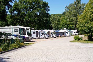
Wohnmobilstellplatz Bad am Stadtwald
Hansar ring 177
N54.08087 N54º4'51º
E 9.96110 E9º57'40"
site code:85573
€13.-- pn for 2 pers, electricity paid
Wohnmobilstellplatz Bad am Stadtwald
Hansar ring 177
N54.08087 N54º4'51º
E 9.96110 E9º57'40"
site code:85573
€13.-- pn for 2 pers, electricity paid
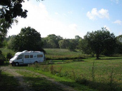
Sulkendrup Molle, Jan Grønbaek & Anette Lyholm
Sulkendrupvej 1
€13.50 pn for 2 persons
electricity paid
no wifi, tip: move the bathroom door upwards and then turn the button.
Nice place, can be a bit noisy.
Sulkendrup Molle, Jan Grønbaek & Anette Lyholm
Sulkendrupvej 1
€13.50 pn for 2 persons
electricity paid
no wifi, tip: move the bathroom door upwards and then turn the button.
Nice place, can be a bit noisy.
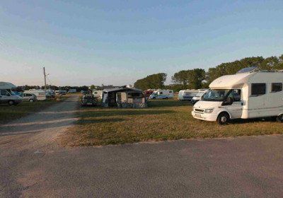
Bellanhoj Camping
Hvidkildevej 66
site code 22414
€25.--pn for 2 pers.
electricity paid
large lawn, sanitary outdated. great location to visit Copenhagen from here.
City camping
discharge wastewater into a well at the Danish flag at the blue containers near camper field - bus [number 2A] to Copenhagen 100m - Copenhagen 4.5km - center 2km
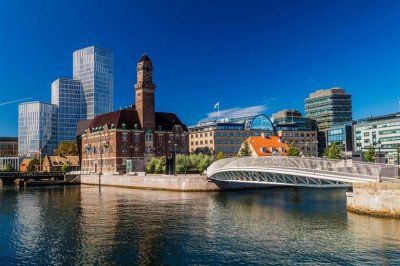
The Malmöhus Castle
The bright red Malmöhus Castle is the oldest intact castle from the Swedish Renaissance . The castle is home to no fewer than four different museums.
The Turning Torso
The city's most talked-about building is the Turning Torso skyscraper, a 190-meter-high structure designed by Spanish architect Santiago Calatrava . The tower dominates the city and is visible from everywhere.
Lomma Camping & ResortSödra Västkustvägen 114, 234 34 Lomma, Sweden, is located 12 km above Malmø
Lomma Camping & Resort
Södra Vastkustvagen 114, 234 34 Lomma, Sweden
Lomma Camping & Resort
Södra Vastkustvagen 114, 234 34 Lomma, Sweden
Sustainability trumps
Växjö is a town in the Småland region and is arguably the greenest town in Europe . Not only are there a lot of parks, the municipal council is also known for developing sustainable initiatives. In September you can attend the FOOD festival where you can try all kinds of local products that are produced in a sustainable way. The town is also surrounded by no fewer than 23 nature reserves and dozens of lakes.
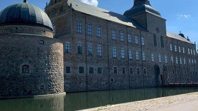
The Kronoberg Castle
You'll also find Kronoberg Castle, one of the best-preserved Renaissance buildings in Sweden . You should definitely not miss this castle if you are in the area.

Sustainability trumps
Växjö is a town in the Småland region and is arguably the greenest town in Europe . Not only are there a lot of parks, the municipal council is also known for developing sustainable initiatives. In September you can attend the FOOD festival where you can try all kinds of local products that are produced in a sustainable way. The town is also surrounded by no fewer than 23 nature reserves and dozens of lakes.
The Kronoberg Castle
You'll also find Kronoberg Castle, one of the best-preserved Renaissance buildings in Sweden . You should definitely not miss this castle if you are in the area.
Gränna, known for its famous red and white mint candy canes. In the town you will find several bakeries where you can buy the delicacy, but also learn everything about the preparation process.
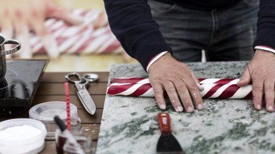
Gränna, known for its famous red and white mint candy canes. In the town you will find several bakeries where you can buy the delicacy, but also learn everything about the preparation process.
Vadstena, a medieval town with breathtaking views of Lake Vättern.
In the town you will find a well-preserved Renaissance castle and a beautiful monastery, the St. Birgitta. For centuries this has been the cultural and commercial center and traded glassware and handmade lace. These crafts can still be found in the local boutiques. In addition to the historical highlights, there is a lot of nature around Vadstena. In the area you will find two large lakes with long sandy beaches, rolling cornfields and wild animals.
Camper stop check a little further on the route Linkoping Friluftmuseet , Tunnbindaregatan 1, 582 46 Linköping, Sweden
and
Cafe Tannefors slussar "sluscafet"
Forshemsgatan 7, 582 44 Linkoping, Sweden
and P SAAB Arena, 582 78 Linkoping, Sweden
Immerse yourself one last time in the beautiful history of the city. Stroll through the narrow streets of Gamla Stan or view the beautiful works of Dali in the Moderna Museet. If you prefer peace and quiet, you can also drive from Vadstena towards the coast near Stockholm and experience a part of the beautiful archipelago. Just outside the city limits, an archipelago of about thirty thousand (!) islands awaits you. The last night you will stay in the center of Stockholm
The historic district of Gamla Stan is the historic center of the city . You are catapulted back in time.
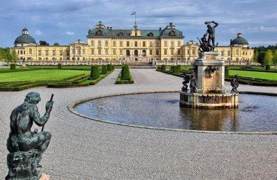
Drottningholm Castle
Drottningholm Castle is one of the biggest attractions in Stockholm. This royal palace was built in the seventeenth century by analogy with the French and Italian buildings of the time. The palace therefore resembles Versailles . Around the castle are beautifully landscaped gardens with a Chinese pavilion that Queen Louisa Ulrika received for her birthday in 1753.
Immerse yourself one last time in the beautiful history of the city. Stroll through the narrow streets of Gamla Stan or view the beautiful works of Dali in the Moderna Museet. If you prefer peace and quiet, you can also drive from Vadstena towards the coast near Stockholm and experience a part of the beautiful archipelago. Just outside the city limits, an archipelago of about thirty thousand (!) islands awaits you. The last night you will stay in the center of Stockholm
The historic district of Gamla Stan is the historic center of the city . You are catapulted back in time.
Drottningholm Castle
Drottningholm Castle is one of the biggest attractions in Stockholm. This royal palace was built in the seventeenth century by analogy with the French and Italian buildings of the time. The palace therefore resembles Versailles . Around the castle are beautifully landscaped gardens with a Chinese pavilion that Queen Louisa Ulrika received for her birthday in 1753.
During a walk you should not be surprised if you spot one of the Swedish Big Five (moose, wolf, lynx, bear or wolverine). Tällberg, on the edge of Lake Siljan. This is the largest lake in Dalarna and has a huge scope, where you have beautiful routes to explore. Around the lake you will find idyllic views, beaches and typical Swedish villages such as Leksand, Orsa and Mora. Tällberg is authentic and peaceful and was the place to retreat for the famous Danish fairy tale writer Hans Christian Andersen. He lost his heart to this village in 1850 and came here mainly to enjoy the peace and conviviality. The lake is ideal for various outdoor activities. Start your stay calmly with a nice walk along one of the banks or rent a canoe and paddle across the lake. Enjoy the photogenic red houses along the banks.
Leksand a village before Tallberg... This village is also considered the most traditional in Dalarna and is known for its crispbread brand. Take a look at the crispbread factory and learn everything about the crispy and airy piece of “bread”. From Leksand you can discover the rolling landscape by bike and you will pass about fifty villages and hamlets. Make an occasional stop for a Swedish fika or a cozy picnic.
Leksand This village is considered to be the most traditional in Dalarna and is known for its crispbread brand. Take a look at the crispbread factory and learn everything about the crispy and airy piece of “bread”. From Leksand you can discover the rolling landscape by bike and you will pass about fifty villages and hamlets. Make a stop every now and then for a Swedish fika or a cozy picnic
Leksand This village is considered to be the most traditional in Dalarna and is known for its crispbread brand. Take a look at the crispbread factory and learn everything about the crispy and airy piece of “bread”. From Leksand you can discover the rolling landscape by bike and you will pass about fifty villages and hamlets. Make a stop every now and then for a Swedish fika or a cozy picnic
The Tännforsen is one of the highest waterfalls in Sweden . The water thunders down no less than 38 meters. The waterfall is also located in a dense coniferous forest , which only increases the fairytale quality of the place. Moreover, in winter the waterfall freezes completely, a unique view.
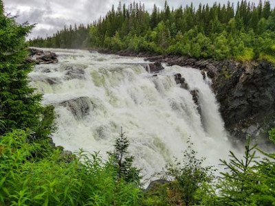
The Tännforsen is one of the highest waterfalls in Sweden . The water thunders down no less than 38 meters. The waterfall is also located in a dense coniferous forest , which only increases the fairytale quality of the place. Moreover, in winter the waterfall freezes completely, a unique view.
Cor Buissant des Amorie responds to FB
Unnamed Road
880 30, Nasaker, Sweden
Gårelehojden
beautiful, but secluded location - on a river - wooded area - water refueling possible, on the way to the seaside resort at the first house [after 30m] right at the rear, just ask before use - pets on a leash - small contribution desired - center 21km
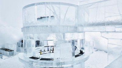
ice hotel
A visit to a husky kennel or opt for a relaxed sauna afternoon.
Underground iron ore mine in KirunaIt's like a city underground. This means the largest underground iron ore mine in the world in Kiruna. During this tour, the bus will take you to a depth of 500 meters. During the tour, the guide will tell you more about the production, the evacuation plan, the history and that modern mining can even cause an entire city to be moved. In the mining environment you get an even better picture through the displays, films and the machines used for ore mining and iron production. Suitable for 6 years and older.
Included: guide, snack. Duration: 2.5 hours. Departure times: from June 1 to October 31 on Tuesdays, Thursdays and Saturdays. Tip: It can be cold in the mine, so bring a sweater
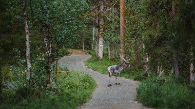
Levi, a small but lively village. The center of Levi has been given its own name: Sirkka; you will find many restaurants and shops.
In summer this is a perfect area for outdoor activities. One of the Finnish specialties is, of course, reindeer. There are a number of restaurants in the center that prepare reindeer according to family recipes. Highly recommended!
Saariselkä is nestled amid breathtaking yet rugged hillside scenery in the Urho Kekkonen National Park. In this national park there are various walks that take you along various lakes and steep gorges. The gorges were created by the meltwater from the Ice Age. Put on your hiking boots and discover the diversity of the park.
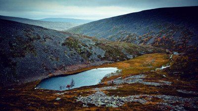
Saariselkä is nestled amid breathtaking yet rugged hillside scenery in the Urho Kekkonen National Park. In this national park there are various walks that take you along various lakes and steep gorges. The gorges were created by the meltwater from the Ice Age. Put on your hiking boots and discover the diversity of the park.
Karasjok. About 90% of the local population speaks Sami and the area is home to about 60,000 reindeer. Visit an authentic Sami family, see the reindeer and hear stories about past and present Sami culture. Sample Sami dishes such as bidos, a traditional reindeer stew, and hear the fascinating stories of the Sami.
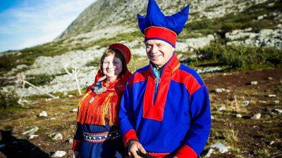
Karasjok. About 90% of the local population speaks Sami and the area is home to about 60,000 reindeer. Visit an authentic Sami family, see the reindeer and hear stories about past and present Sami culture. Sample Sami dishes such as bidos, a traditional reindeer stew, and hear the fascinating stories of the Sami.
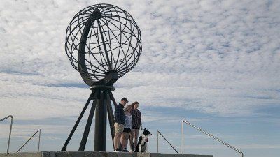
On the way, don't forget to stop at Hjemmeluft, where you can admire ancient rock carvings between 4200 and 500 BC. The area around the North Cape is fascinating, with spectacular nature and picturesque fishing villages. The North Cape itself is an island and consists of Honningsvåg, Nordvågen, Kamøyvær, Gjesvær, Skarsvåg and Repvåg on the mainland. North of the treeline, Nordkapp offers a wide variety of sights and activities, such as arctic food with fresh produce, as well as a rich history and culture. Do you want to know everything about this region? Then visit the Nordkappmusseet (North Cape Museum).
Nordkapphallen on the North Cape
Get to know the story of the North Cape, Europe's northernmost point, in the Nordkapphallen. In this visitor center you will learn more about the seasons, history, St. John's Chapel, the cave of light and the northernmost post office are also discussed. This ticket gives you access to the Panorama Film, historical exhibitions and the Cave of Lights. Don't forget to visit the restaurant, you will be treated to a fantastic view of the Arctic Ocean
Important information:
-The ticket is valid for 24 hours. -The tickets are personal and not transferable to others. - You must be in possession of a valid ID. -Parking is possible for a fee, take into account about €20 for the car. -Children under the age of five have free access. -When you travel to the North Cape in winter, you have to take convoy driving into account.
Drive past the town of Gjesvær. From here you can make an excursion to the bird island of Gjecaerstappen where you will find hundreds of puffins. You can also take a walk to the natural rock arch of Kirkeporten which immediately offers you an impressive view of the North Cape. Don't miss Skarsvåg. Nestled in a rugged landscape, this lovely fishing village is the northernmost fishing village in the world. The church in Honningsvåg is also worth a visit. This church was inaugurated in 1885 after a hurricane razed the old church in Kjelvik. The church was built in neo-Gothic style and is an important place for the population. After the war, the church was used as accommodation, bakery and kitchen, and today it symbolizes hope, courage and unity - and as a tourist attraction in Honningsvåg. Did you know that the sun shines through here continuously from mid-May to the end of July? Watch the sunset over the Barents Sea from the North Cape Plateau tonight.
If you want to visit the real northernmost tip of the mainland, you should go to Kap Knivskjellodden. This is only possible with a walk of about eighteen kilometers there and back. Follow the cairns about one and a half meters high for the right direction. You cannot miss these stones, because next to heather nothing grows. You may even see a herd of reindeer passing by.
Drive past the town of Gjesvær. From here you can make an excursion to the bird island Gjecaerstappen where you will find hundreds of puffins. You can also take a walk to the natural rock arch of Kirkeporten which immediately offers you an impressive view of the North Cape. Don't miss Skarsvåg. Nestled in a rugged landscape, this lovely fishing village is the northernmost fishing village in the world. The church in Honningsvåg is also worth a visit. This church was inaugurated in 1885 after a hurricane razed the old church in Kjelvik. The church was built in neo-Gothic style and is an important place for the population. After the war, the church was used as accommodation, bakery and kitchen, and today it symbolizes hope, courage and unity - and as a tourist attraction in Honningsvåg. Did you know that the sun shines through here continuously from mid-May to the end of July? Watch the sunset over the Barents Sea from the North Cape Plateau tonight.
Drive past the town of Gjesvær. From here you can make an excursion to the bird island Gjecaerstappen where you will find hundreds of puffins. You can also take a walk to the natural rock arch of Kirkeporten which immediately offers you an impressive view of the North Cape. Don't miss Skarsvåg. Nestled in a rugged landscape, this lovely fishing village is the northernmost fishing village in the world. The church in Honningsvåg is also worth a visit. This church was inaugurated in 1885 after a hurricane razed the old church in Kjelvik. The church was built in neo-Gothic style and is an important place for the population. After the war, the church was used as accommodation, bakery and kitchen, and today it symbolizes hope, courage and unity - and as a tourist attraction in Honningsvåg. Did you know that the sun shines through here continuously from mid-May to the end of July? Watch the sunset over the Barents Sea from the North Cape Plateau tonight.
Best hikes to Hvaldimir
Zick-Zack-Weg Einstieg
Hiking Highlight..From the height there is a beautiful view over the city and the bay. You can also take a taxi to the viewpoint.
Eisbar Museum
Hiking Highlight....The Polar Bear Museum is a MUST visit when visiting Hammerfest. Here you can also join the polar bear club.
Gatefulle Forsol
Hiking Highlight.....The Sami once lived here. The sea level was a few meters higher than it is now.
Blick auf Hammerfest
Highlight
Easily accessible by bike; from here you have a good view of the whole city and the bay.
Review of Cecret Lake TrailI
This is a beautiful route with beautiful views of the mountains, wildflowers, the Lake of the Upper and Valleys. Many people travel this trail so don't think you have an individual experience. Some online trail guides say this is an "easy" trail. It is not, even for seasoned hikers. We had a 3 year old with us and he was able to do it but it gets steep and rocky at the top with several switchbacks. This is not for pushchairs or wheelchairs.
The parking is difficult. We were lucky enough to find a spot in the lower parking lot. There really should be a shuttle more than just two days on the weekend.
The temperature is lovely - at least 15 degrees cooler than down in the city. Lots of water and snacks. Although it is cooler you can get sunburnt so wear sunscreen or a hat or both.
It took us an hour and a half to hike slowly to the lake and an hour to get down. Without kids it would be faster but the joy is seeing things along the way, not rushing.
Dogs are not allowed on this trail and camping is not allowed near the lake as it is a watershed lake.
Well worth the walk! It is so beautiful!
From Alta we go via the E6 in the direction of Badderen, on the way we see where we stop and where we are going to do something.
From Alta we go via the E6 in the direction of Badderen, on the way we see where we stop and where we are going to do something.
Taking a piece of the country in lovely walks
Taking a piece of the country in lovely walks
Possible whale watching.
Possible whale watching.
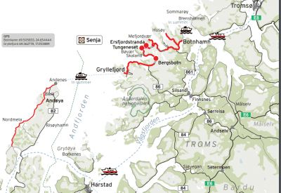
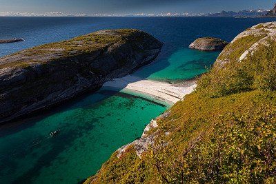
Route Senja: from Gryllefjord to Botnhamn: 102 kilometers
Senja is a beautiful island located north of the Arctic Circle. You will find a mix of mountains, beaches, rocky coastlines, colorful fishing villages and the northernmost zoo in the world (Polar Park)
Route Senja: from Gryllefjord to Botnhamn: 102 kilometers
Senja is a beautiful island located north of the Arctic Circle. You will find a mix of mountains, beaches, rocky coastlines, colorful fishing villages and the northernmost zoo in the world (Polar Park)
Once you have arrived in Narvik you can explore the area. Preferably drive to the 1,810 meter long cable car that will take you to the highest point in Narvik. From this point you have a breathtaking view over the city, the deep Ototfjorden and in the area you will see several mountain peaks. Narvik is a 'complete picture': the city has islands to the west, fjords stretching north to south, and mountains in every other direction. The city is known for iron, which was transported by rail for decades. You can learn everything about the history of this town in the Museum Nord – Historic Museum of Narvik.
Once you have arrived in Narvik you can explore the area. Preferably drive to the 1,810 meter long cable car that will take you to the highest point in Narvik. From this point you have a breathtaking view over the city, the deep Ototfjorden and in the area you will see several mountain peaks. Narvik is a 'complete picture': the city has islands to the west, fjords stretching north to south, and mountains in every other direction. The city is known for iron, which was transported by rail for decades. You can learn everything about the history of this town in the Museum Nord – Historic Museum of Narvik.
From Narvik we take another trip to Sweden, Abisko National Park
From Narvik we take another trip to Sweden, Abisko National Park
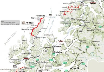
From here we enter the Lofoten
From here we enter the Lofoten
Whale Museum,
see if we can take the drill to Bodo from here
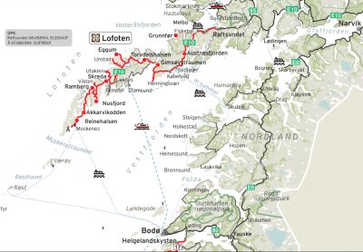
see if we can take the drill to Bodo from here
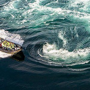
Come by and experience the bustling tidal current of Saltstraumen through RIB! We travel through a breathtaking landscape and you are in close contact with the elements. We will make several stops during the tour and you will learn about our proud coastal heritage.
Mjelle Pure nature! Beautiful beach with beautiful blue water. The beach can be reached on foot after a nice walk.
Address:8100 Misvær
Nettstedet:http://www.misvaercamping.no/?...
Address:8100 Misvær
Nettstedet:http://www.misvaercamping.no/?...
Mo i Rana (Norwegian pronunciation: [ˈmuː i ˈrɑːnɑ]) is a town and administrative center of Rana Municipality in Nordland County, Norway. It is located just south of the Arctic Circle and in the Helgeland region of Nordland. Some of the outlying areas of the city include the suburbs of Båsmoen and Ytteren to the north and Selfors to the east.
Mo i Rana (Norwegian pronunciation: [ˈmuː i ˈrɑːnɑ]) is a town and administrative center of Rana Municipality in Nordland County, Norway. It is located just south of the Arctic Circle and in the Helgeland region of Nordland. Some of the outlying areas of the city include the suburbs of Båsmoen and Ytteren to the north and Selfors to the east.
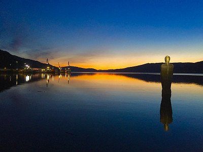
Havmannen stands in the water of the Ranfjord about 15 meters from the water's edge. The water surface rises and falls with the tide. The position of the image is also determined by its relationship with the structure of the city.
The statue stands with its back to the city, looking out over the fjord, towards the open sea. It seems to focus on its own thoughts, turning inward to its inner space, both as a physical and a mental state. Despite its scale, this statue is not a monument. The rhetoric is addressed to each of us individually, and this discussion is private. It belongs to the experiences that we cannot share with others. We base our sense of having something in common on the belief that we share these existential experiences.
If we go a step further and look at the sculpture in its surroundings, in the landscape formed by the city and its buildings, the fjord with its water and the hills with their intricate stone formations, we can experience that the sculpture loses its materially heavy presence and is transformed into a black outline, almost a hole or negative shape sculpted in the sky.
Finneidfjord is a place in Hemnes Municipality, Nordland County, Norway. Finneidfjord has 389 inhabitants and has an area of 0.6 km²
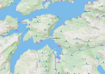
Finneidfjord is a place in Hemnes Municipality, Nordland County, Norway. Finneidfjord has 389 inhabitants and has an area of 0.6 km²
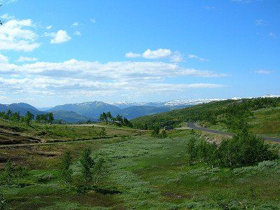
Nature and geology De
Hemnes municipality has a varied nature. The river Røssåga flows through a valley in a south-north direction from Tustervatnet, the northwestern arm of Røssvatn, to Sørfjorden. The valley is open and wide and has good farmland. The forest line runs at 400-500 meters above sea level. More than half of the area of the municipality is above this level and only six percent of the municipality is below 150 meters above sea level. This level largely coincides with the cultivation limit.
At the top of Bryggfjelldalen, a side valley to the Røssågas Valley to the east, lies the 2.1-kilometer-long Grønndal Cave and Ytterlihullet, one of Norway's deepest caves, 180 meters deep.
The rock in Hemnes is strongly influenced by the Caledonian mountain range folding (Caledonian orogeny). Large areas in the municipality are covered with mica shale and mica gneiss, as well as Precambrian and Cambrosilur rocks that have been heavily modified during the folding of the mountain range. North of Røssvatnet, in the southern part of the municipality, is Okstindan with Oksskolten, the highest mountain in Northern Norway with 1916 meters above sea level. A significant portion of the mountain range is covered by the Okstind Glacier.
Magmatic rocks, mainly granite, have invaded the transformed rocks in some places north of the municipality, for example in the central parts of the Hemnes peninsula and in a few smaller areas west of Skarpsundet, at the inlet to the southern arms of the Ranfjord , Sørfjorden and Elsfjorden . Otherwise, the folding chain in Hemnes has different areas with limestone and marble, for example in the northeast, south
Here we go into the Okstidan nature reserve, also called the roof of Norway, but we still have to find out whether it is good to drive with the camper
Here we go into the Okstidan nature reserve, also called the roof of Norway, but we still have to find out whether it is good to drive with the camper
Okstindan is a mountain range in the inner Helgeland district in Nordland county, Norway. It is located in the municipality of Hemnes. Mount Oksskolten is part of the Okstindan Mountains and is the highest mountain in Northern Norway.
Okstindan is a mountain range in the inner Helgeland district in Nordland county, Norway. It is located in the municipality of Hemnes. Mount Oksskolten is part of the Okstindan Mountains and is the highest mountain in Northern Norway.
VENNESUND CAMPING KYSTVEIEN 5 8920 SOMNA
0047 7502 7375
N65°12'55" E12°2'33"
CAMPSITE SIZE: 2 HA
OPEN: 01-01-2021 - 31-12-2021
Vennesund Campsite in Somna in the Nordland regionSince 2018 Vennesund Camping has had a new sanitary building with, among other things, large family bathrooms. In addition, the hytter has been renovated and, in addition to the "grass camping pitches", a number of paved places (with extra power connections) have also been realised. Handy in bad weather. The campsite has free WIFI and the restaurant (Brygge) at the campsite is very popular. From the terrace at the restaurant you have a wonderful view of the sea and the ferries.
Musk Ox safari.
Look for the last herd of wild musk oxen in Dovrefjell National Park. Musk oxen live in groups on the open tundra plains of northern Siberia, Greenland, Canada, Alaska and also Norway.
Musk oxen are arctic animals and are mainly found in cold regions, but they have been reintroduced in certain northern areas, such as Russia, Alaska, Spitsbergen and the Dovrefjell National Park in Norway. This Dovrefjell National Park is therefore one of the few places in the world where the musk ox still alive in the wild
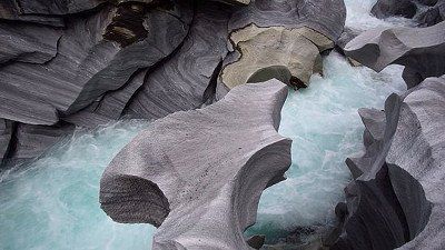
The Geirangerfjord is 'just' a 15 kilometer long arm of the enormous Storfjord. But it is one of the most impressive you can find in the Norwegian fjords. I will explore it by car, on foot and by ferry. these are the most beautiful sights of the Geirangerfjord.
This fjord is home to many waterfalls. All waterfalls have been given names. And they are all easy to see from the water. A boat trip is therefore the most suitable for this.
Geirangerfjord Viewpoint
When you arrive driving to the village of Geiranger the road meanders from top to bottom. At the top you can see a lookout called Ørnesvingen. From here you have a nice overview of the first part of the fjord. Which is also the narrowest. Perfect for a photo. With a bit of luck you will see a ferry and only then you will see how immense the gorge is. And how small the ship.
climatic park 2469
OPNINGTIDERDayleg guiding: mid-June – mid-August: Klokka 10.30 and 14.00. Besøksadresse: Klimapark 2469, Galdhøpiggvegen 1357, 2687 Bøverdalen
There is also a bus from Lom going here
climatic park 2469
OPNINGTIDERDayleg guiding: mid-June – mid-August: Klokka 10.30 and 14.00. Besøksadresse: Klimapark 2469, Galdhøpiggvegen 1357, 2687 Bøverdalen
There is also a bus from Lom going here
›
Lone Camping Bergen is a large campsite with a wide variety of camping pitches. Due to the weather, the many paved camping pitches and the large number of accommodations are no superfluous luxury. Prefer on the grass? Which can. You are also directly on the Haukelandmeer. The various terraces on the campsite give you a nice view of the surrounding mountains and the lake.
Visit Bergen
Bus stop is in front of the campsite. Halfway through Nesttun, change to the express tram (Skyss) to Bergen. Times and information about the Bergen Card (including a discount on public transport and museums) are available at the reception. In Bergen, the fish market, the Floibanen and Bryggen are the biggest attractions. A little less weather? No problem. In the many restaurants, shops and shopping centers you can forget about bad weather.
At Lone Camping Mountains
You will find good sanitary facilities at the campsite. Also with nice family bathrooms (shower, toilet and sink in 1 room). Just in front of the campsite you will find a gas station and a large supermarket. You can do your shopping on foot. Or score a warm bite at the gas station. They also sell sandwiches at the gas station. In bad weather you can take them to the TV room at the campsite.
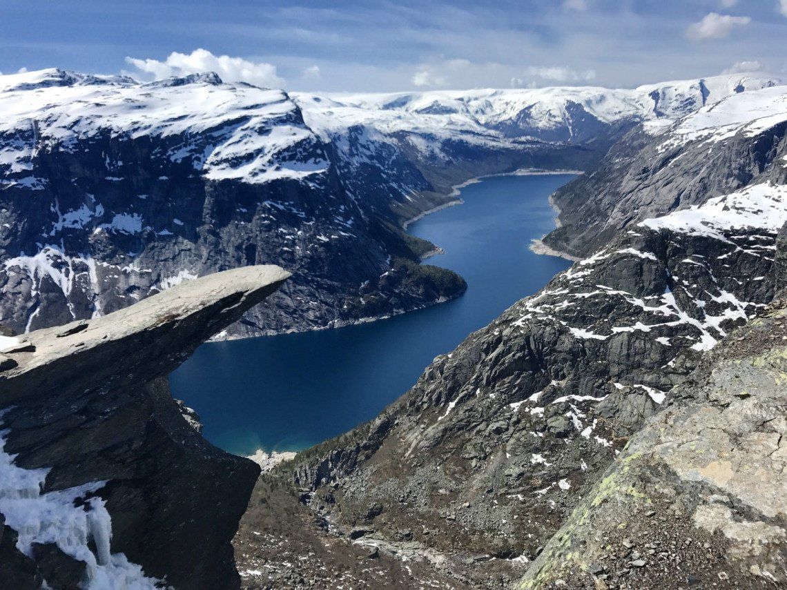
Make sure you are fit enough
The hike to Trolltunga is really often underestimated. Not only in the heaviness of the walk, but also in clothing. First, it is not a walk through the park . You have to take into account a walk that will take you about 8 to 10 hours (round trip). If you stop a lot to take pictures and have lunch, it will take you longer. If you are not fit, do not start the walk.
Wear hiking clothes
Sunny and nice weather was predicted for us, we even waited for it. However, the weather above turned to rain and light snow. Wearing good hiking clothes is a must. Rain-resistant clothing certainly can't hurt either. I also recommend wearing layers so that you can put on and take off something. A pair of gloves is therefore not superfluous.
This is how you get to the Trolltunga start
By car
You can leave your car at three parking spaces. The Trolltunga hike starts at P2 or P3.
- In the village of Tyssedal (also called P1: 220 parking spaces). P1 costs NOK 300 (about €30) per day. + shuttle costs to P3
- At the bottom of the trail at Skjeggedal (P2: 180 places). P2 costs NOK 500 (about €50) per day
- 1 kilometer after the official start of the walk, at the upper parking or Mågelitopp (P3: 30 places). P3 costs NOK 600 (about €60) per day. .
By shuttle bus
Due to the limited parking capacity, it is recommended to come by public transport. You can take public transport from the town of Odda or Tyssedal to P2 or P3.
There are two companies that arrange shuttle buses between Odda, P1 Tyssedal and P2 Skjeggedal: Odda Taxi (OT) and TaxiBus Odda (TBO). These run in the season from June 1 to September 30. The price from Odda to P2 Skjeggedal is NOK 230–250 (return ticket)
Not yet known whether we will visit Oslo, but above Oslo we will go back into Sweden
Not yet known whether we will visit Oslo, but above Oslo we will go back into Sweden
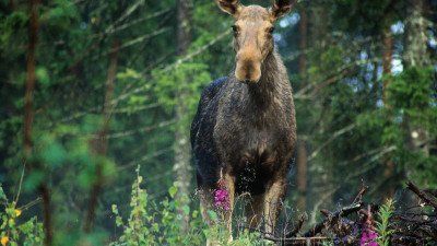
white moose has been spotted here
white moose has been spotted here
Route
Show newest first- 51.8061 5.4411
- 51° 48' 21.8" N 5° 26' 28" E
- 54.0698 9.999
- 54° 4' 11.4" N 9° 59' 56.4" E
- 55.3235 10.8003
- 55° 19' 24.7" N 10° 48' 1.3" E
- 55.6746 12.5582
- 55° 40' 28.7" N 12° 33' 29.3" E
- 55.5516 13.0671
- 55° 33' 5.6" N 13° 4' 1.4" E
- 55.6902 13.0599
- 55° 41' 24.7" N 13° 3' 35.7" E
- 55.5627 11.6179
- 55° 33' 45.9" N 11° 37' 4.5" E
- 56.879 14.8059
- 56° 52' 44.4" N 14° 48' 21.1" E
- 58.025 14.4701
- 58° 1' 30.1" N 14° 28' 12.3" E
- 58.4476 14.8902
- 58° 26' 51.4" N 14° 53' 24.8" E
- 58.5877 16.1924
- 58° 35' 15.9" N 16° 11' 32.7" E
- 59.0999 18.0332
- 59° 5' 59.8" N 18° 1' 59.5" E
- 59.3293 18.0686
- 59° 19' 45.6" N 18° 4' 6.9" E
- 60.8261 14.9921
- 60° 49' 34" N 14° 59' 31.5" E
- 61.3365 14.164
- 61° 20' 11.4" N 14° 9' 50.4" E
- 63.307 13.2732
- 63° 18' 25.4" N 13° 16' 23.6" E
- 63.4453 12.7404
- 63° 26' 42.9" N 12° 44' 25.5" E
- 63.5997 16.8175
- 63° 35' 59" N 16° 49' 3" E
- 65.0956 17.1123
- 65° 5' 44.2" N 17° 6' 44.2" E
- 67.8502 20.6022
- 67° 51' 0.7" N 20° 36' 8" E
- 67.7833 24.8678
- 67° 46' 59.8" N 24° 52' 4.2" E
- 68.4197 27.41
- 68° 25' 10.8" N 27° 24' 36" E
- 70.1643 28.5518
- 70° 9' 51.5" N 28° 33' 6.6" E
- 70.351 31.1342
- 70° 21' 3.6" N 31° 8' 3" E
- 69.4714 25.5129
- 69° 28' 16.9" N 25° 30' 46.5" E
- 70.9823 25.9702
- 70° 58' 56.2" N 25° 58' 12.7" E
- 71.0983 25.376
- 71° 5' 54" N 25° 22' 33.8" E
- 70.6634 23.682
- 70° 39' 48.4" N 23° 40' 55.1" E
- 69.9573 23.2872
- 69° 57' 26.4" N 23° 17' 14.1" E
- 69.8452 22.0261
- 69° 50' 42.6" N 22° 1' 34.1" E
- 69.7721 20.9964
- 69° 46' 19.4" N 20° 59' 47.1" E
- 69.495 21.4671
- 69° 29' 42.2" N 21° 28' 1.4" E
- 69.6492 18.9553
- 69° 38' 57.1" N 18° 57' 19.2" E
- 69.232 17.9809
- 69° 13' 55.3" N 17° 58' 51.1" E
- 69.5074 17.9029
- 69° 30' 26.8" N 17° 54' 10.5" E
- 69.4659 17.2269
- 69° 27' 57.3" N 17° 13' 36.9" E
- 68.4385 17.4273
- 68° 26' 18.6" N 17° 25' 38.1" E
- 68.3495 18.8312
- 68° 20' 58.3" N 18° 49' 52.5" E
- 68.554 17.5313
- 68° 33' 14.2" N 17° 31' 52.8" E
- 69.3161 16.1202
- 69° 18' 57.9" N 16° 7' 12.8" E
- 67.9002 13.0465
- 67° 54' 0.7" N 13° 2' 47.5" E
- 67.2804 14.4049
- 67° 16' 49.3" N 14° 24' 17.7" E
- 67.2229 14.6096
- 67° 13' 22.5" N 14° 36' 34.5" E
- 67.2076 14.949
- 67° 12' 27.4" N 14° 56' 56.4" E
- 67.1229 15.0039
- 67° 7' 22.4" N 15° 0' 14" E
- 67.0676 15.3854
- 67° 4' 3.5" N 15° 23' 7.6" E
- 66.3579 14.1676
- 66° 21' 28.4" N 14° 10' 3.5" E
- 66.3102 14.1274
- 66° 18' 36.6" N 14° 7' 38.6" E
- 66.1911 13.828
- 66° 11' 28" N 13° 49' 40.6" E
- 66.0766 13.8235
- 66° 4' 35.9" N 13° 49' 24.8" E
- 65.9064 13.8094
- 65° 54' 23.2" N 13° 48' 33.9" E
- 65.7215 13.9595
- 65° 43' 17.5" N 13° 57' 34.1" E
- 65.5996 13.9163
- 65° 35' 58.6" N 13° 54' 58.6" E
- 65.3841 13.3661
- 65° 23' 2.9" N 13° 21' 57.9" E
- 65.4015 12.5449
- 65° 24' 5.3" N 12° 32' 41.7" E
- 65.5056 12.3746
- 65° 30' 20" N 12° 22' 28.4" E
- 65.2409 12.1125
- 65° 14' 27.1" N 12° 6' 45" E
- 65.1824 12.1183
- 65° 10' 56.8" N 12° 7' 5.8" E
- 65.1013 12.0024
- 65° 6' 4.5" N 12° 0' 8.7" E
- 64.4565 11.5118
- 64° 27' 23.5" N 11° 30' 42.4" E
- 64.3092 11.2397
- 64° 18' 33.2" N 11° 14' 22.9" E
- 63.465 10.4534
- 63° 27' 54" N 10° 27' 12.1" E
- 62.2209 9.5494
- 62° 13' 15.2" N 9° 32' 57.7" E
- 62.0951 7.2183
- 62° 5' 42.2" N 7° 13' 5.9" E
- 61.8297 8.56
- 61° 49' 47" N 8° 33' 35.9" E
- 60.3735 5.4592
- 60° 22' 24.8" N 5° 27' 33.1" E
- 60.8608 7.1118
- 60° 51' 38.8" N 7° 6' 42.4" E
- 60.0635 6.5813
- 60° 3' 48.5" N 6° 34' 52.6" E
- 60.1168 6.5597
- 60° 7' 0.3" N 6° 33' 35.1" E
- 58.9989 6.0925
- 58° 59' 56" N 6° 5' 32.9" E
- 59.9146 10.7474
- 59° 54' 52.5" N 10° 44' 50.6" E
- 58.4715 11.6802
- 58° 28' 17.4" N 11° 40' 48.7" E
- 57.7118 11.9802
- 57° 42' 42.5" N 11° 58' 48.8" E
- 56.6472 12.874
- 56° 38' 49.9" N 12° 52' 26.5" E
- 55.6177 12.1122
- 55° 37' 3.9" N 12° 6' 43.8" E
- 55.4467 8.4966
- 55° 26' 48" N 8° 29' 47.8" E
- 52.488 6.1049
- 52° 29' 16.8" N 6° 6' 17.7" E
- 51.8048 5.436
- 51° 48' 17.5" N 5° 26' 9.5" E
Travelogue
Wohnmobilstellplatz Bad am Stadtwald
Hansar ring 177
N54.08087 N54º4'51º
E 9.96110 E9º57'40"
site code:85573
€13.-- pn for 2 pers, electricity paid
Wohnmobilstellplatz Bad am Stadtwald
Hansar ring 177
N54.08087 N54º4'51º
E 9.96110 E9º57'40"
site code:85573
€13.-- pn for 2 pers, electricity paid
Sulkendrup Molle, Jan Grønbaek & Anette Lyholm
Sulkendrupvej 1
€13.50 pn for 2 persons
electricity paid
no wifi, tip: move the bathroom door upwards and then turn the button.
Nice place, can be a bit noisy.
Sulkendrup Molle, Jan Grønbaek & Anette Lyholm
Sulkendrupvej 1
€13.50 pn for 2 persons
electricity paid
no wifi, tip: move the bathroom door upwards and then turn the button.
Nice place, can be a bit noisy.
Bellanhoj Camping
Hvidkildevej 66
site code 22414
€25.--pn for 2 pers.
electricity paid
large lawn, sanitary outdated. great location to visit Copenhagen from here.
City camping
discharge wastewater into a well at the Danish flag at the blue containers near camper field - bus [number 2A] to Copenhagen 100m - Copenhagen 4.5km - center 2km
The Malmöhus Castle
The bright red Malmöhus Castle is the oldest intact castle from the Swedish Renaissance . The castle is home to no fewer than four different museums.
The Turning Torso
The city's most talked-about building is the Turning Torso skyscraper, a 190-meter-high structure designed by Spanish architect Santiago Calatrava . The tower dominates the city and is visible from everywhere.
Lomma Camping & ResortSödra Västkustvägen 114, 234 34 Lomma, Sweden, is located 12 km above Malmø
Lomma Camping & Resort
Södra Vastkustvagen 114, 234 34 Lomma, Sweden
Lomma Camping & Resort
Södra Vastkustvagen 114, 234 34 Lomma, Sweden
Sustainability trumps
Växjö is a town in the Småland region and is arguably the greenest town in Europe . Not only are there a lot of parks, the municipal council is also known for developing sustainable initiatives. In September you can attend the FOOD festival where you can try all kinds of local products that are produced in a sustainable way. The town is also surrounded by no fewer than 23 nature reserves and dozens of lakes.
The Kronoberg Castle
You'll also find Kronoberg Castle, one of the best-preserved Renaissance buildings in Sweden . You should definitely not miss this castle if you are in the area.
Gränna, known for its famous red and white mint candy canes. In the town you will find several bakeries where you can buy the delicacy, but also learn everything about the preparation process.
Gränna, known for its famous red and white mint candy canes. In the town you will find several bakeries where you can buy the delicacy, but also learn everything about the preparation process.
Vadstena, a medieval town with breathtaking views of Lake Vättern.
In the town you will find a well-preserved Renaissance castle and a beautiful monastery, the St. Birgitta. For centuries this has been the cultural and commercial center and traded glassware and handmade lace. These crafts can still be found in the local boutiques. In addition to the historical highlights, there is a lot of nature around Vadstena. In the area you will find two large lakes with long sandy beaches, rolling cornfields and wild animals.
Camper stop check a little further on the route Linkoping Friluftmuseet , Tunnbindaregatan 1, 582 46 Linköping, Sweden
and
Cafe Tannefors slussar "sluscafet"
Forshemsgatan 7, 582 44 Linkoping, Sweden
and P SAAB Arena, 582 78 Linkoping, Sweden
Immerse yourself one last time in the beautiful history of the city. Stroll through the narrow streets of Gamla Stan or view the beautiful works of Dali in the Moderna Museet. If you prefer peace and quiet, you can also drive from Vadstena towards the coast near Stockholm and experience a part of the beautiful archipelago. Just outside the city limits, an archipelago of about thirty thousand (!) islands awaits you. The last night you will stay in the center of Stockholm
The historic district of Gamla Stan is the historic center of the city . You are catapulted back in time.
Drottningholm Castle
Drottningholm Castle is one of the biggest attractions in Stockholm. This royal palace was built in the seventeenth century by analogy with the French and Italian buildings of the time. The palace therefore resembles Versailles . Around the castle are beautifully landscaped gardens with a Chinese pavilion that Queen Louisa Ulrika received for her birthday in 1753.
During a walk you should not be surprised if you spot one of the Swedish Big Five (moose, wolf, lynx, bear or wolverine). Tällberg, on the edge of Lake Siljan. This is the largest lake in Dalarna and has a huge scope, where you have beautiful routes to explore. Around the lake you will find idyllic views, beaches and typical Swedish villages such as Leksand, Orsa and Mora. Tällberg is authentic and peaceful and was the place to retreat for the famous Danish fairy tale writer Hans Christian Andersen. He lost his heart to this village in 1850 and came here mainly to enjoy the peace and conviviality. The lake is ideal for various outdoor activities. Start your stay calmly with a nice walk along one of the banks or rent a canoe and paddle across the lake. Enjoy the photogenic red houses along the banks.
Leksand a village before Tallberg... This village is also considered the most traditional in Dalarna and is known for its crispbread brand. Take a look at the crispbread factory and learn everything about the crispy and airy piece of “bread”. From Leksand you can discover the rolling landscape by bike and you will pass about fifty villages and hamlets. Make an occasional stop for a Swedish fika or a cozy picnic.
Leksand This village is considered to be the most traditional in Dalarna and is known for its crispbread brand. Take a look at the crispbread factory and learn everything about the crispy and airy piece of “bread”. From Leksand you can discover the rolling landscape by bike and you will pass about fifty villages and hamlets. Make a stop every now and then for a Swedish fika or a cozy picnic
Leksand This village is considered to be the most traditional in Dalarna and is known for its crispbread brand. Take a look at the crispbread factory and learn everything about the crispy and airy piece of “bread”. From Leksand you can discover the rolling landscape by bike and you will pass about fifty villages and hamlets. Make a stop every now and then for a Swedish fika or a cozy picnic
The Tännforsen is one of the highest waterfalls in Sweden . The water thunders down no less than 38 meters. The waterfall is also located in a dense coniferous forest , which only increases the fairytale quality of the place. Moreover, in winter the waterfall freezes completely, a unique view.
The Tännforsen is one of the highest waterfalls in Sweden . The water thunders down no less than 38 meters. The waterfall is also located in a dense coniferous forest , which only increases the fairytale quality of the place. Moreover, in winter the waterfall freezes completely, a unique view.
Cor Buissant des Amorie responds to FB
Unnamed Road
880 30, Nasaker, Sweden
Gårelehojden
beautiful, but secluded location - on a river - wooded area - water refueling possible, on the way to the seaside resort at the first house [after 30m] right at the rear, just ask before use - pets on a leash - small contribution desired - center 21km
ice hotel
A visit to a husky kennel or opt for a relaxed sauna afternoon.
Underground iron ore mine in KirunaIt's like a city underground. This means the largest underground iron ore mine in the world in Kiruna. During this tour, the bus will take you to a depth of 500 meters. During the tour, the guide will tell you more about the production, the evacuation plan, the history and that modern mining can even cause an entire city to be moved. In the mining environment you get an even better picture through the displays, films and the machines used for ore mining and iron production. Suitable for 6 years and older.
Included: guide, snack. Duration: 2.5 hours. Departure times: from June 1 to October 31 on Tuesdays, Thursdays and Saturdays. Tip: It can be cold in the mine, so bring a sweater
Levi, a small but lively village. The center of Levi has been given its own name: Sirkka; you will find many restaurants and shops.
In summer this is a perfect area for outdoor activities. One of the Finnish specialties is, of course, reindeer. There are a number of restaurants in the center that prepare reindeer according to family recipes. Highly recommended!
Saariselkä is nestled amid breathtaking yet rugged hillside scenery in the Urho Kekkonen National Park. In this national park there are various walks that take you along various lakes and steep gorges. The gorges were created by the meltwater from the Ice Age. Put on your hiking boots and discover the diversity of the park.
Saariselkä is nestled amid breathtaking yet rugged hillside scenery in the Urho Kekkonen National Park. In this national park there are various walks that take you along various lakes and steep gorges. The gorges were created by the meltwater from the Ice Age. Put on your hiking boots and discover the diversity of the park.
Karasjok. About 90% of the local population speaks Sami and the area is home to about 60,000 reindeer. Visit an authentic Sami family, see the reindeer and hear stories about past and present Sami culture. Sample Sami dishes such as bidos, a traditional reindeer stew, and hear the fascinating stories of the Sami.
Karasjok. About 90% of the local population speaks Sami and the area is home to about 60,000 reindeer. Visit an authentic Sami family, see the reindeer and hear stories about past and present Sami culture. Sample Sami dishes such as bidos, a traditional reindeer stew, and hear the fascinating stories of the Sami.
On the way, don't forget to stop at Hjemmeluft, where you can admire ancient rock carvings between 4200 and 500 BC. The area around the North Cape is fascinating, with spectacular nature and picturesque fishing villages. The North Cape itself is an island and consists of Honningsvåg, Nordvågen, Kamøyvær, Gjesvær, Skarsvåg and Repvåg on the mainland. North of the treeline, Nordkapp offers a wide variety of sights and activities, such as arctic food with fresh produce, as well as a rich history and culture. Do you want to know everything about this region? Then visit the Nordkappmusseet (North Cape Museum).
Nordkapphallen on the North Cape
Get to know the story of the North Cape, Europe's northernmost point, in the Nordkapphallen. In this visitor center you will learn more about the seasons, history, St. John's Chapel, the cave of light and the northernmost post office are also discussed. This ticket gives you access to the Panorama Film, historical exhibitions and the Cave of Lights. Don't forget to visit the restaurant, you will be treated to a fantastic view of the Arctic Ocean
Important information:
-The ticket is valid for 24 hours. -The tickets are personal and not transferable to others. - You must be in possession of a valid ID. -Parking is possible for a fee, take into account about €20 for the car. -Children under the age of five have free access. -When you travel to the North Cape in winter, you have to take convoy driving into account.
Drive past the town of Gjesvær. From here you can make an excursion to the bird island of Gjecaerstappen where you will find hundreds of puffins. You can also take a walk to the natural rock arch of Kirkeporten which immediately offers you an impressive view of the North Cape. Don't miss Skarsvåg. Nestled in a rugged landscape, this lovely fishing village is the northernmost fishing village in the world. The church in Honningsvåg is also worth a visit. This church was inaugurated in 1885 after a hurricane razed the old church in Kjelvik. The church was built in neo-Gothic style and is an important place for the population. After the war, the church was used as accommodation, bakery and kitchen, and today it symbolizes hope, courage and unity - and as a tourist attraction in Honningsvåg. Did you know that the sun shines through here continuously from mid-May to the end of July? Watch the sunset over the Barents Sea from the North Cape Plateau tonight.
If you want to visit the real northernmost tip of the mainland, you should go to Kap Knivskjellodden. This is only possible with a walk of about eighteen kilometers there and back. Follow the cairns about one and a half meters high for the right direction. You cannot miss these stones, because next to heather nothing grows. You may even see a herd of reindeer passing by.
Drive past the town of Gjesvær. From here you can make an excursion to the bird island Gjecaerstappen where you will find hundreds of puffins. You can also take a walk to the natural rock arch of Kirkeporten which immediately offers you an impressive view of the North Cape. Don't miss Skarsvåg. Nestled in a rugged landscape, this lovely fishing village is the northernmost fishing village in the world. The church in Honningsvåg is also worth a visit. This church was inaugurated in 1885 after a hurricane razed the old church in Kjelvik. The church was built in neo-Gothic style and is an important place for the population. After the war, the church was used as accommodation, bakery and kitchen, and today it symbolizes hope, courage and unity - and as a tourist attraction in Honningsvåg. Did you know that the sun shines through here continuously from mid-May to the end of July? Watch the sunset over the Barents Sea from the North Cape Plateau tonight.
Drive past the town of Gjesvær. From here you can make an excursion to the bird island Gjecaerstappen where you will find hundreds of puffins. You can also take a walk to the natural rock arch of Kirkeporten which immediately offers you an impressive view of the North Cape. Don't miss Skarsvåg. Nestled in a rugged landscape, this lovely fishing village is the northernmost fishing village in the world. The church in Honningsvåg is also worth a visit. This church was inaugurated in 1885 after a hurricane razed the old church in Kjelvik. The church was built in neo-Gothic style and is an important place for the population. After the war, the church was used as accommodation, bakery and kitchen, and today it symbolizes hope, courage and unity - and as a tourist attraction in Honningsvåg. Did you know that the sun shines through here continuously from mid-May to the end of July? Watch the sunset over the Barents Sea from the North Cape Plateau tonight.
Best hikes to Hvaldimir
Zick-Zack-Weg Einstieg
Hiking Highlight..From the height there is a beautiful view over the city and the bay. You can also take a taxi to the viewpoint.
Eisbar Museum
Hiking Highlight....The Polar Bear Museum is a MUST visit when visiting Hammerfest. Here you can also join the polar bear club.
Gatefulle Forsol
Hiking Highlight.....The Sami once lived here. The sea level was a few meters higher than it is now.
Blick auf Hammerfest
Highlight
Easily accessible by bike; from here you have a good view of the whole city and the bay.
Review of Cecret Lake TrailI
This is a beautiful route with beautiful views of the mountains, wildflowers, the Lake of the Upper and Valleys. Many people travel this trail so don't think you have an individual experience. Some online trail guides say this is an "easy" trail. It is not, even for seasoned hikers. We had a 3 year old with us and he was able to do it but it gets steep and rocky at the top with several switchbacks. This is not for pushchairs or wheelchairs.
The parking is difficult. We were lucky enough to find a spot in the lower parking lot. There really should be a shuttle more than just two days on the weekend.
The temperature is lovely - at least 15 degrees cooler than down in the city. Lots of water and snacks. Although it is cooler you can get sunburnt so wear sunscreen or a hat or both.
It took us an hour and a half to hike slowly to the lake and an hour to get down. Without kids it would be faster but the joy is seeing things along the way, not rushing.
Dogs are not allowed on this trail and camping is not allowed near the lake as it is a watershed lake.
Well worth the walk! It is so beautiful!
From Alta we go via the E6 in the direction of Badderen, on the way we see where we stop and where we are going to do something.
From Alta we go via the E6 in the direction of Badderen, on the way we see where we stop and where we are going to do something.
Taking a piece of the country in lovely walks
Taking a piece of the country in lovely walks
Possible whale watching.
Possible whale watching.
Route Senja: from Gryllefjord to Botnhamn: 102 kilometers
Senja is a beautiful island located north of the Arctic Circle. You will find a mix of mountains, beaches, rocky coastlines, colorful fishing villages and the northernmost zoo in the world (Polar Park)
Route Senja: from Gryllefjord to Botnhamn: 102 kilometers
Senja is a beautiful island located north of the Arctic Circle. You will find a mix of mountains, beaches, rocky coastlines, colorful fishing villages and the northernmost zoo in the world (Polar Park)
Once you have arrived in Narvik you can explore the area. Preferably drive to the 1,810 meter long cable car that will take you to the highest point in Narvik. From this point you have a breathtaking view over the city, the deep Ototfjorden and in the area you will see several mountain peaks. Narvik is a 'complete picture': the city has islands to the west, fjords stretching north to south, and mountains in every other direction. The city is known for iron, which was transported by rail for decades. You can learn everything about the history of this town in the Museum Nord – Historic Museum of Narvik.
Once you have arrived in Narvik you can explore the area. Preferably drive to the 1,810 meter long cable car that will take you to the highest point in Narvik. From this point you have a breathtaking view over the city, the deep Ototfjorden and in the area you will see several mountain peaks. Narvik is a 'complete picture': the city has islands to the west, fjords stretching north to south, and mountains in every other direction. The city is known for iron, which was transported by rail for decades. You can learn everything about the history of this town in the Museum Nord – Historic Museum of Narvik.
From Narvik we take another trip to Sweden, Abisko National Park
From Narvik we take another trip to Sweden, Abisko National Park
From here we enter the Lofoten
From here we enter the Lofoten
Whale Museum,
see if we can take the drill to Bodo from here
see if we can take the drill to Bodo from here
Come by and experience the bustling tidal current of Saltstraumen through RIB! We travel through a breathtaking landscape and you are in close contact with the elements. We will make several stops during the tour and you will learn about our proud coastal heritage.
Mjelle Pure nature! Beautiful beach with beautiful blue water. The beach can be reached on foot after a nice walk.
Address:8100 Misvær
Nettstedet:http://www.misvaercamping.no/?...
Address:8100 Misvær
Nettstedet:http://www.misvaercamping.no/?...
Mo i Rana (Norwegian pronunciation: [ˈmuː i ˈrɑːnɑ]) is a town and administrative center of Rana Municipality in Nordland County, Norway. It is located just south of the Arctic Circle and in the Helgeland region of Nordland. Some of the outlying areas of the city include the suburbs of Båsmoen and Ytteren to the north and Selfors to the east.
Mo i Rana (Norwegian pronunciation: [ˈmuː i ˈrɑːnɑ]) is a town and administrative center of Rana Municipality in Nordland County, Norway. It is located just south of the Arctic Circle and in the Helgeland region of Nordland. Some of the outlying areas of the city include the suburbs of Båsmoen and Ytteren to the north and Selfors to the east.
Havmannen stands in the water of the Ranfjord about 15 meters from the water's edge. The water surface rises and falls with the tide. The position of the image is also determined by its relationship with the structure of the city.
The statue stands with its back to the city, looking out over the fjord, towards the open sea. It seems to focus on its own thoughts, turning inward to its inner space, both as a physical and a mental state. Despite its scale, this statue is not a monument. The rhetoric is addressed to each of us individually, and this discussion is private. It belongs to the experiences that we cannot share with others. We base our sense of having something in common on the belief that we share these existential experiences.
If we go a step further and look at the sculpture in its surroundings, in the landscape formed by the city and its buildings, the fjord with its water and the hills with their intricate stone formations, we can experience that the sculpture loses its materially heavy presence and is transformed into a black outline, almost a hole or negative shape sculpted in the sky.
Finneidfjord is a place in Hemnes Municipality, Nordland County, Norway. Finneidfjord has 389 inhabitants and has an area of 0.6 km²
Finneidfjord is a place in Hemnes Municipality, Nordland County, Norway. Finneidfjord has 389 inhabitants and has an area of 0.6 km²
Nature and geology De
Hemnes municipality has a varied nature. The river Røssåga flows through a valley in a south-north direction from Tustervatnet, the northwestern arm of Røssvatn, to Sørfjorden. The valley is open and wide and has good farmland. The forest line runs at 400-500 meters above sea level. More than half of the area of the municipality is above this level and only six percent of the municipality is below 150 meters above sea level. This level largely coincides with the cultivation limit.
At the top of Bryggfjelldalen, a side valley to the Røssågas Valley to the east, lies the 2.1-kilometer-long Grønndal Cave and Ytterlihullet, one of Norway's deepest caves, 180 meters deep.
The rock in Hemnes is strongly influenced by the Caledonian mountain range folding (Caledonian orogeny). Large areas in the municipality are covered with mica shale and mica gneiss, as well as Precambrian and Cambrosilur rocks that have been heavily modified during the folding of the mountain range. North of Røssvatnet, in the southern part of the municipality, is Okstindan with Oksskolten, the highest mountain in Northern Norway with 1916 meters above sea level. A significant portion of the mountain range is covered by the Okstind Glacier.
Magmatic rocks, mainly granite, have invaded the transformed rocks in some places north of the municipality, for example in the central parts of the Hemnes peninsula and in a few smaller areas west of Skarpsundet, at the inlet to the southern arms of the Ranfjord , Sørfjorden and Elsfjorden . Otherwise, the folding chain in Hemnes has different areas with limestone and marble, for example in the northeast, south
Here we go into the Okstidan nature reserve, also called the roof of Norway, but we still have to find out whether it is good to drive with the camper
Here we go into the Okstidan nature reserve, also called the roof of Norway, but we still have to find out whether it is good to drive with the camper
Okstindan is a mountain range in the inner Helgeland district in Nordland county, Norway. It is located in the municipality of Hemnes. Mount Oksskolten is part of the Okstindan Mountains and is the highest mountain in Northern Norway.
Okstindan is a mountain range in the inner Helgeland district in Nordland county, Norway. It is located in the municipality of Hemnes. Mount Oksskolten is part of the Okstindan Mountains and is the highest mountain in Northern Norway.
VENNESUND CAMPING KYSTVEIEN 5 8920 SOMNA
0047 7502 7375
N65°12'55" E12°2'33"
CAMPSITE SIZE: 2 HA
OPEN: 01-01-2021 - 31-12-2021
Vennesund Campsite in Somna in the Nordland regionSince 2018 Vennesund Camping has had a new sanitary building with, among other things, large family bathrooms. In addition, the hytter has been renovated and, in addition to the "grass camping pitches", a number of paved places (with extra power connections) have also been realised. Handy in bad weather. The campsite has free WIFI and the restaurant (Brygge) at the campsite is very popular. From the terrace at the restaurant you have a wonderful view of the sea and the ferries.
Musk Ox safari.
Look for the last herd of wild musk oxen in Dovrefjell National Park. Musk oxen live in groups on the open tundra plains of northern Siberia, Greenland, Canada, Alaska and also Norway.
Musk oxen are arctic animals and are mainly found in cold regions, but they have been reintroduced in certain northern areas, such as Russia, Alaska, Spitsbergen and the Dovrefjell National Park in Norway. This Dovrefjell National Park is therefore one of the few places in the world where the musk ox still alive in the wild
The Geirangerfjord is 'just' a 15 kilometer long arm of the enormous Storfjord. But it is one of the most impressive you can find in the Norwegian fjords. I will explore it by car, on foot and by ferry. these are the most beautiful sights of the Geirangerfjord.
This fjord is home to many waterfalls. All waterfalls have been given names. And they are all easy to see from the water. A boat trip is therefore the most suitable for this.
Geirangerfjord Viewpoint
When you arrive driving to the village of Geiranger the road meanders from top to bottom. At the top you can see a lookout called Ørnesvingen. From here you have a nice overview of the first part of the fjord. Which is also the narrowest. Perfect for a photo. With a bit of luck you will see a ferry and only then you will see how immense the gorge is. And how small the ship.
climatic park 2469
OPNINGTIDERDayleg guiding: mid-June – mid-August: Klokka 10.30 and 14.00. Besøksadresse: Klimapark 2469, Galdhøpiggvegen 1357, 2687 Bøverdalen
There is also a bus from Lom going here
climatic park 2469
OPNINGTIDERDayleg guiding: mid-June – mid-August: Klokka 10.30 and 14.00. Besøksadresse: Klimapark 2469, Galdhøpiggvegen 1357, 2687 Bøverdalen
There is also a bus from Lom going here
›
Lone Camping Bergen is a large campsite with a wide variety of camping pitches. Due to the weather, the many paved camping pitches and the large number of accommodations are no superfluous luxury. Prefer on the grass? Which can. You are also directly on the Haukelandmeer. The various terraces on the campsite give you a nice view of the surrounding mountains and the lake.
Visit Bergen
Bus stop is in front of the campsite. Halfway through Nesttun, change to the express tram (Skyss) to Bergen. Times and information about the Bergen Card (including a discount on public transport and museums) are available at the reception. In Bergen, the fish market, the Floibanen and Bryggen are the biggest attractions. A little less weather? No problem. In the many restaurants, shops and shopping centers you can forget about bad weather.
At Lone Camping Mountains
You will find good sanitary facilities at the campsite. Also with nice family bathrooms (shower, toilet and sink in 1 room). Just in front of the campsite you will find a gas station and a large supermarket. You can do your shopping on foot. Or score a warm bite at the gas station. They also sell sandwiches at the gas station. In bad weather you can take them to the TV room at the campsite.
Make sure you are fit enough
The hike to Trolltunga is really often underestimated. Not only in the heaviness of the walk, but also in clothing. First, it is not a walk through the park . You have to take into account a walk that will take you about 8 to 10 hours (round trip). If you stop a lot to take pictures and have lunch, it will take you longer. If you are not fit, do not start the walk.
Wear hiking clothes
Sunny and nice weather was predicted for us, we even waited for it. However, the weather above turned to rain and light snow. Wearing good hiking clothes is a must. Rain-resistant clothing certainly can't hurt either. I also recommend wearing layers so that you can put on and take off something. A pair of gloves is therefore not superfluous.
This is how you get to the Trolltunga start
By car
You can leave your car at three parking spaces. The Trolltunga hike starts at P2 or P3.
- In the village of Tyssedal (also called P1: 220 parking spaces). P1 costs NOK 300 (about €30) per day. + shuttle costs to P3
- At the bottom of the trail at Skjeggedal (P2: 180 places). P2 costs NOK 500 (about €50) per day
- 1 kilometer after the official start of the walk, at the upper parking or Mågelitopp (P3: 30 places). P3 costs NOK 600 (about €60) per day. .
By shuttle bus
Due to the limited parking capacity, it is recommended to come by public transport. You can take public transport from the town of Odda or Tyssedal to P2 or P3.
There are two companies that arrange shuttle buses between Odda, P1 Tyssedal and P2 Skjeggedal: Odda Taxi (OT) and TaxiBus Odda (TBO). These run in the season from June 1 to September 30. The price from Odda to P2 Skjeggedal is NOK 230–250 (return ticket)
Not yet known whether we will visit Oslo, but above Oslo we will go back into Sweden
Not yet known whether we will visit Oslo, but above Oslo we will go back into Sweden
white moose has been spotted here
white moose has been spotted here
Comments (2)
Comments from Freeontour users
Sehr Interessant hat mir sehr geholfen ? wünsche eine gute Reise
Danke, sie auch, ich had der route weiter abgeschlossen, und gehen wieder auf die brucke zu hause
Route is nog niet af, we gaan terug via Noorwegen.