For the year 2021 we had set ourselves a few travel destinations and discarded them again. The result was a tour of Istria in spring. An exploration in southern Italy was planned for autumn. Since we are retirees with no time constraints, we first went leisurely to the German wine route. Many other mobile drivers also had this idea and it became tight in sought-after locations. In general, the increase in new cars was noticeable everywhere. Places are slowly becoming scarce, even in the off-season. For Italy we had a plan which places we really wanted to see. Tuscany e.g. has a lot to offer, but is not an ideal area for motorhome enthusiasts in terms of parking spaces. For this we discovered - mostly by accident - other beautiful spots. Overall, it was an interesting and relaxing tour.
Day
Bad Vilbel, Deutschland
61118 Bad Vilbel, Deutschland
50° 10' 56.4" N 8° 44' 22.1" E
50.1823356 8.7394805
• Head southwest on Parkstraße. Go for 30 m.
• Take the 1st exit from roundabout onto Niddastraße. Go for 206 m.
• Turn right onto Kasseler Straße. Go for 89 m.
• Take the 2nd exit from roundabout onto Homburger Straße. Go for 94 m.
• Pass 2 roundabouts and continue on Homburger Straße. Go for 895 m.
• Take the 1st exit from roundabout onto B3 toward A661/Frankfurt. Go for 4.3 km.
• Take the left exit toward Würzburg/Offenbach/Frankfurt-Ost onto A661. Go for 11.4 km.
• Take exit 17 toward Köln/Wiesbaden/Flughafen F. Kreuz onto A3. Go for 8.5 km.
• Take exit 50 toward Basel/Darmstadt onto A5. Go for 23.6 km.
• Continue on E451 (Darmstädter Kreuz) toward A67/Stuttgart/Mannheim. Go for 754 m.
• Continue on A67. Go for 33.4 km.
• Take exit 10 toward Saarbrücken/Kaiserslautern/Ludwigshafen/MA-Sandhofen onto A6. Go for 27.9 km.
• Take exit 19 toward Grünstadt/Monsheim/Bad Dürkheim/Deutsche Weinstraße. Go for 461 m.
• Take the 3rd exit from roundabout onto B271 toward A61/Mannheim/A6/Neustadt/Weinstr./Bad Dürkheim/Kirchheim. Go for 7.7 km.
• Turn left onto Freinsheimer Straße (K4) toward Freinsheim. Go for 188 m.
• Arrive at Freinsheimer Straße (K4). Your destination is on the right.
☍
119,5 km
(1 hrs. 14 min.)
Kallstadt, Deutschland
We want to take it easy and visit the German Wine Route.
Via Kallstadt, Hambacher Schloss and Bad Bergzabern it goes to Bad Bellingen.
49° 29' 28.5" N 8° 10' 39" E
49.4912517 8.1775040
• Head toward Im Mosenborn on Freinsheimer Straße (K4). Go for 1.2 km.
• Continue on K4. Go for 293 m.
• Turn right onto L455. Go for 2.2 km.
• Take the 3rd exit from roundabout onto Altenbacher Straße. Go for 965 m.
• Turn left onto B37. Go for 897 m.
• Turn right onto B271 toward Neustadt/Weinstr./A65/Bad Dürkheim-Süd. Go for 274 m.
• Turn left onto B271. Go for 11.0 km.
• Take the left exit toward Karlsruhe/Neustadt/Weinstr. onto A65. Go for 6.6 km.
• Take exit 13 toward Neustadt-Süd/Speyer/Holiday-Park. Go for 309 m.
• Turn right onto B39 toward Kaiserslautern/Neustadt/Weinstr. Go for 441 m.
• Turn left onto K9 toward NW-Hambach/NW-Diedesfeld. Go for 2.9 km.
• Continue on Weinstraße (L512). Go for 235 m.
• Turn left onto K9. Go for 83 m.
• Continue on Eichstraße (K9). Go for 688 m.
• Continue on Schloßstraße (K9). Go for 1.7 km.
• Continue on Hambacher Schloss (K9). Go for 21 m.
• Arrive at Hambacher Schloss (K9).
☍
29,8 km
( 29 min.)
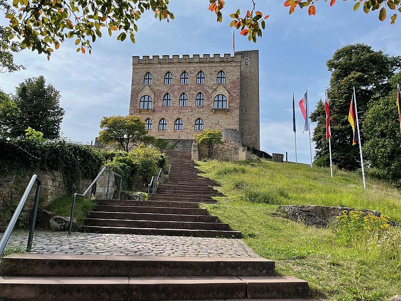
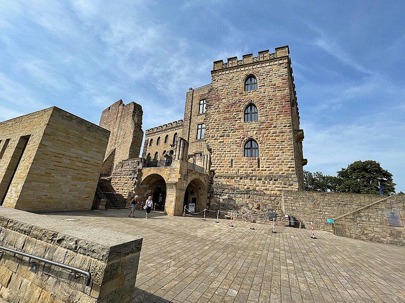
Day
Hambacher Schloss, Schlossstraße, Neustadt an der Weinstraße, Deutschland
German history took place here.
Schlossstraße, 67434 Neustadt an der Weinstraße, Deutschland
49° 19' 30" N 8° 7' 4.9" E
49.3249971 8.1180238
• Head north on Hambacher Schloss (K9). Go for 70 m.
• Turn slightly left onto Hambacher Schloss (K14). Go for 54 m.
• Continue on Freiheitstraße (K14). Go for 321 m.
• Turn slightly right onto Freiheitstraße (K14). Go for 517 m.
• Turn left onto Triftbrunnenweg (K14). Go for 1.1 km.
• Turn right onto In der Almel (K14). Go for 117 m.
• Turn left onto In der Almel (K14). Go for 116 m.
• Turn slightly right onto In der Almel (K14). Go for 337 m.
• Continue on Römerweg (K14). Go for 899 m.
• Turn left onto Weinstraße (K14). Go for 101 m.
• Turn right onto Dammstraße (L512). Go for 988 m.
• Continue on Mittelhambacher Straße (K9) toward A65/B39/Speyer/Landau. Go for 2.9 km.
• Turn right onto B39 toward A65/Speyer. Go for 466 m.
• Turn left and take ramp onto A65 toward Karlsruhe. Go for 17.9 km.
• Take exit 17 toward Landau-Süd/Wissembourg/Bad Bergzabern onto B38. Go for 2.7 km.
• Take left ramp onto B38 toward Weißenburg/Bad Bergzabern/Impflingen/LD-Mörzheim. Go for 6.5 km.
• Take the 2nd exit from roundabout onto Firststraße (B38) toward Wissembourg/Bad Bergzabern/Ingenheim. Go for 202 m.
• Turn left onto Hauptstraße (B38) toward Bad Bergzabern/Strasbourg. Go for 555 m.
• Turn right onto Bergzaberner Straße (B38) toward Straßburg/Bad Bergzabern. Go for 6.1 km.
• Continue on Landauer Straße (B38). Go for 179 m.
• Take the 2nd exit from roundabout onto Landauer Straße (B38) toward Klinikum LD-SÜW/Krankenhaus Ld-SÜW/Zentrum. Go for 770 m.
• Turn right onto Weinstraße (L508) toward Pleisweiler/Klinikum LD-SÜW. Go for 298 m.
• Turn left onto Königsberger Straße. Go for 56 m.
• Continue on Danziger Straße. Go for 202 m.
• Arrive at Danziger Straße.
☍
43,4 km
( 41 min.)
Day
Stellplatz am Weingut Hitziger
Liebfrauenbergweg 3, 76887, Bad Bergzabern, Germany
49° 6' 25" N 7° 59' 48" E
49.1069444 7.9966667
• Head southeast on Danziger Straße. Go for 202 m.
• Continue on Königsberger Straße. Go for 56 m.
• Turn right onto Weinstraße (L508). Go for 394 m.
• Take the 2nd exit from roundabout onto Kapeller Straße (B427) toward Karlsruhe/Kandel/Strasbourg/B38/Wissembourg. Go for 153 m.
• Turn right onto Steinfelder Straße (L545) toward Steinfeld/Lauterbourg. Go for 845 m.
• Take the 2nd exit from roundabout onto L545. Go for 6.7 km.
• Continue on L545. Go for 554 m.
• Continue on Waldhof (L545). Go for 217 m.
• Continue on L545. Go for 2.5 km.
• Continue on Bienwaldziegelhütte (L545). Go for 2.1 km.
• Continue on L545. Go for 443 m.
• Continue on Bienwaldmühle (L545). Go for 403 m.
• Continue on L545. Go for 1.3 km.
• Continue on Salmbacher Passage (L545). Go for 190 m.
• Continue on L545. Go for 2.7 km.
• Continue on Bienwaldmühler Straße (L545). Go for 704 m.
• Continue on Maxstraße (L545). Go for 323 m.
• Turn right onto Hauptstraße toward Wissembourg. Go for 171 m.
• Continue on Rue des Tirailleurs Tunisiens (D403). Go for 362 m.
• Turn left onto Rue du 19 Mars (D3). Go for 1.2 km.
• Take the 2nd exit from roundabout toward Haguenau/Strasbourg/Seltz. Go for 262 m.
• Take ramp onto A35. Go for 15.0 km.
• Take exit 56 toward Karlsruhe/Bâle/Rastatt/Baden-Baden/Roppenheim/Beinheim onto D504. Go for 1.4 km.
• Pass 2 roundabouts and continue on D504. Go for 3.8 km.
• Continue on B500. Go for 6.0 km.
• Take ramp onto A5 toward Basel. Go for 127 km.
• Take exit 65 toward Müllheim/Neuenburg/Badenweiler/Bad Bellingen. Go for 333 m.
• Take the 2nd exit from roundabout onto B378 toward Bad Bellingen/Badenweiler/Müllheim/Neuenburg/Karlsruhe/A5. Go for 366 m.
• Take the 1st exit from roundabout onto B378 toward Bad Bellingen/Badenweiler/Müllheim/Neuenburg. Go for 168 m.
• Turn right onto K4946 toward Neuenburg/Zentrum. Go for 194 m.
• Take the 1st exit from roundabout onto Basler Straße (L134). Go for 7.4 km.
• Continue on K6347. Go for 3.1 km.
• Turn left toward Badstraße. Go for 65 m.
• Turn right onto Badstraße. Go for 140 m.
• Turn left. Go for 18 m.
• Arrive at your destination.
☍
187,0 km
(2 hrs. 2 min.)
Day
Stellplatz der Balinea Therme
Badstraße 14, 79415, Bad Bellingen, Germany
47° 43' 47" N 7° 33' 7" E
47.7297222 7.5519444
• Head toward Badstraße. Go for 18 m.
• Turn right onto Badstraße. Go for 140 m.
• Turn left toward Umgehungsstraße/K6347. Go for 65 m.
• Turn left onto Umgehungsstraße (K6347). Go for 6.7 km.
• Turn right onto L137 toward Basel/A5/Karlsruhe. Go for 177 m.
• Take ramp onto A5. Go for 12.9 km.
• Continue on A2. Go for 14.1 km.
• Keep right onto A2 (Verzweigung Augst) toward Chiasso/Gotthard/Luzern/Bern/Arisdorf. Go for 28.2 km.
• Take the left exit toward Chiasso/Gotthard/Luzern/Zürich/Rothrist onto A1/A2. Go for 8.8 km.
• Take exit 47 toward Chiasso/Gotthard/Luzern/Reiden onto A2 (Verzweigung Wiggertal). Go for 139 km.
• Take exit 42 toward Quinto/Ambrì-Piotta/Rodi/Dalpe. Go for 408 m.
• Turn left onto 2. Go for 1.4 km.
• Turn left onto Nucleo Rodi. Go for 40 m.
• Arrive at Nucleo Rodi. Your destination is on the right.
☍
211,8 km
(2 hrs. 14 min.)
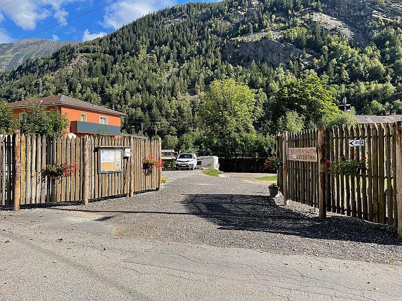
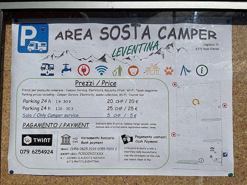
Day
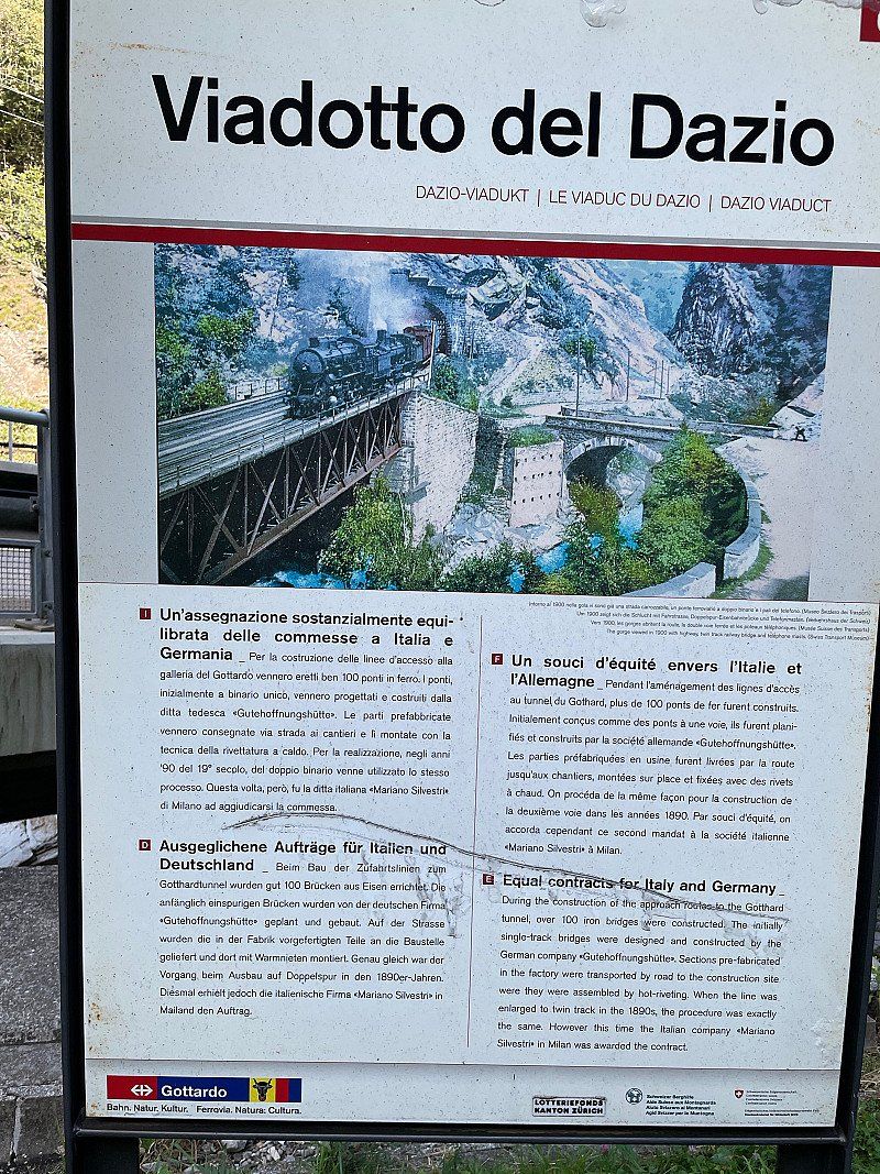
SP in Rodi-Fiesso, Prato, Schweiz
Good place for an overnight stay. The Viadotto del Dazio and a gorge can be reached on foot.
Rodi-Fiesso, 6772 Prato, Schweiz
46° 29' 26.6" N 8° 44' 15.3" E
46.4907300 8.7375800
• Head northeast on Nucleo Rodi. Go for 34 m.
• Turn left onto Strada della Stazione. Go for 156 m.
• Turn left onto Nucleo Rodi. Go for 18 m.
• Turn right onto Fiesso di Mezzo (2). Go for 1.2 km.
• Turn right toward A2. Go for 57 m.
• Take ramp onto A2 toward Bellinzona/Faido. Go for 98.0 km.
• Continue on A9 (Autostrada dei Laghi). Go for 31.0 km.
• Take the left exit onto A8 (Autostrada dei Laghi). Go for 5.1 km.
• Take the exit toward E64/Torino/A4/Genova/A7/Bologna/A1 onto A50 (Tangenziale Ovest). Go for 32.1 km.
• Continue on A1 (Autostrada del Sole). Go for 85.3 km.
• Take the exit toward Fidenza/SS9/Salsomaggiore T. Go for 581 m.
• Continue toward Strada Provinciale di Soragna/SP12. Go for 39 m.
• Take the 2nd exit from roundabout onto Strada Provinciale di Soragna (SP12) toward Autostrade/A1/A15/Fidenza/Parma/Piacenza/Salsomaggiore T./Tabiano. Go for 603 m.
• Continue toward Strada Provinciale di Soragna/SP12. Go for 35 m.
• Take the 1st exit from roundabout onto Strada Provinciale di Soragna (SP12). Go for 813 m.
• Continue toward Strada Provinciale di Cannetolo/SP63. Go for 43 m.
• Take the 2nd exit from roundabout onto Strada Provinciale di Cannetolo (SP63) toward Fontanellato. Go for 2.4 km.
• Take the 1st exit from roundabout onto Strada Provinciale di Cannetolo (SP63). Go for 5.5 km.
• Take the 1st exit from roundabout onto Strada Comunale Berettine. Go for 842 m.
• Take the 2nd exit from roundabout onto Strada Comunale Berettine. Go for 635 m.
• Take the 3rd exit from roundabout onto Strada Comunale del Priobato. Go for 561 m.
• Arrive at Strada Comunale del Priobato. Your destination is on the right.
☍
265,2 km
(2 hrs. 40 min.)
Day
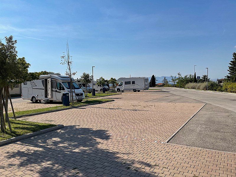
Area Parking Nord
A popular stop on the way to southern Italy for years. The SP is only practical, but the old town with the castle as the center and many restaurants is worth seeing
Via XXIV Maggio, 43012, Fontanellato, Italy
44° 52' 41" N 10° 10' 11" E
44.8780556 10.1697222
• Head southwest on Strada Comunale del Priobato. Go for 398 m.
• Take the 1st exit from roundabout onto Strada Comunale Berettine. Go for 505 m.
• Take the 2nd exit from roundabout onto Strada Comunale Berettine. Go for 3.6 km.
• Continue on Frazione Priorato. Go for 572 m.
• Take the 3rd exit from roundabout onto Via Emilia (SS9). Go for 1.1 km.
• Take the 1st exit from roundabout onto Via Emilia (SS9). Go for 3.2 km.
• Take ramp onto A15 (Autostrada della Cisa) toward La Spezia. Go for 95.5 km.
• Take the exit toward Firenze/A11/E76/Livorno onto A12 (Autostrada Azzurra). Go for 112 km.
• Take the exit toward Rosignano Marittimo/E80/Grosseto/A12/Roma/Vada/SS208/Cecina/Castellina M./S. Luce/Pisa onto SS1 (Strada Statale Aurelia). Go for 1.9 km.
• Keep left onto Strada Statale Aurelia (SS1) toward Grosseto/Cecina/SR206/Pisa/Vada/SP13. Go for 97 m.
• Take the 2nd exit from roundabout toward Pisa/SR206/Grosseto/Vada. Go for 392 m.
• Take the 1st exit from roundabout onto Via Emilia (SR206) toward Cecina/Vada/Grosseto/SS1. Go for 782 m.
• Take the 1st exit from roundabout onto Località Stradone della Torre (SP13). Go for 2.6 km.
• Pass 2 roundabouts and continue on Strada Provinciale della Torre (SP13). Go for 1.5 km.
• Take the 2nd exit from roundabout onto Via Don Antonio Vellutini. Go for 453 m.
• Take the 3rd exit from roundabout onto Strada Provinciale Vecchia Aurelia (SP39). Go for 173 m.
• Pass 2 roundabouts. Go for 296 m.
• Continue on Via 20 Giugno 1944. Go for 170 m.
• Take the 1st exit from roundabout onto Via Irma Bandiera. Go for 214 m.
• Turn left onto Via dei Cavalleggeri. Go for 2.4 km.
• Turn right onto Via dei Cavalleggeri. Go for 138 m.
• Arrive at Via dei Cavalleggeri. Your destination is on the left.
☍
227,7 km
(2 hrs. 14 min.)
Day
Day
Area Sosta Mazzanta
Unfortunately, the CP around Cecina were all full and there was only space left on the SP.
Via dei Cavalleggeri Nuovo, 57016, Rosignano Marittimo, Italy
43° 19' 41" N 10° 27' 38" E
43.3280556 10.4605556
• Head southwest on Via dei Cavalleggeri. Go for 14 m.
• Turn left onto Via Valle d'Aosta. Go for 186 m.
• Take the 3rd exit from Via Valle d'Aosta roundabout onto Via Monte Cervino. Go for 218 m.
• Turn right onto Via Pozzuolo. Go for 825 m.
• Continue on Via Campilunghi. Go for 1.8 km.
• Continue toward Via Francesco Domenico Guerrazzi. Go for 47 m.
• Take the 3rd exit from roundabout onto Via Francesco Domenico Guerrazzi. Go for 2.3 km.
• Continue straight ahead. Go for 46 m.
• Take the 1st exit from roundabout. Go for 46 m.
• Keep left toward Autostrada. Go for 35 m.
• Take the 2nd exit from roundabout onto Via San Pietro in Palazzi. Go for 490 m.
• Turn right onto Strada Regionale di Val di Cecina (SR68). Go for 143 m.
• Keep right onto Strada Regionale di Val di Cecina (SR68). Go for 1.0 km.
• Pass 4 roundabouts and continue on Strada Regionale di Val di Cecina (SR68). Go for 10.4 km.
• Take the 1st exit from roundabout onto Località Molino di Rialdo (SR68). Go for 2.5 km.
• Continue on Strada Regionale di Val di Cecina (SR68). Go for 242 m.
• Pass 2 roundabouts and continue on Strada Regionale di Val di Cecina (SR68). Go for 9.7 km.
• Continue toward Via di Val di Cecina. Go for 34 m.
• Take the 1st exit from roundabout onto Via di Val di Cecina. Go for 211 m.
• Continue on Strada Regionale di Val di Cecina (SR68). Go for 5.3 km.
• Take the 1st exit from Via Volterrana roundabout onto Via Volterrana (SR68). Go for 9.0 km.
• Take the 1st exit from roundabout onto Viale Giuseppe Garibaldi (SR68). Go for 851 m.
• Turn left onto Via del Poderino. Go for 580 m.
• Turn left onto Via del Poderino. Go for 384 m.
• Turn right. Go for 42 m.
• Turn slightly right. Go for 81 m.
• Arrive at your destination on the right.
☍
46,4 km
( 52 min.)
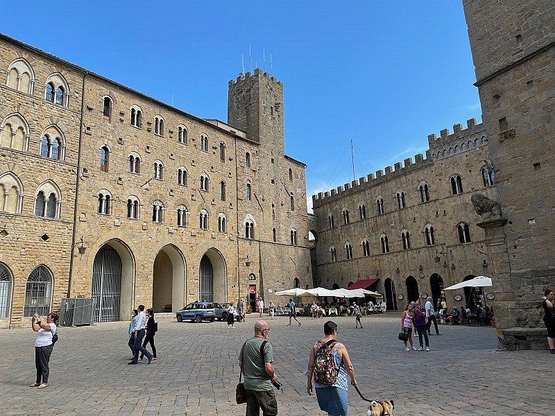
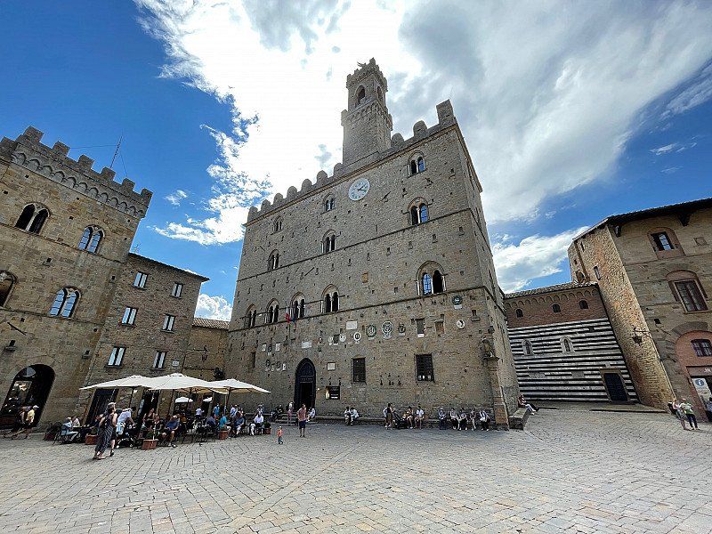
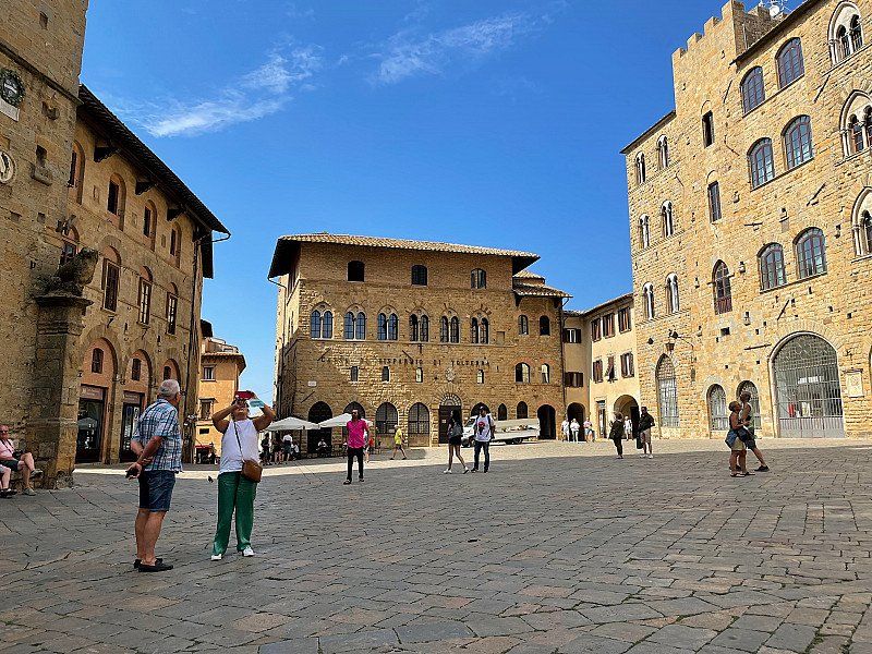
Day
Voltera
Absolutely worth seeing city. Overnight stays are also possible in the parking lot. Electricity V / E available.
Viale dei Filosofi, 56048, Volterra, Italy
43° 24' 12" N 10° 51' 49" E
43.4033333 10.8636111
• Head east. Go for 123 m.
• Turn left onto Via del Poderino. Go for 384 m.
• Turn right onto Via del Poderino. Go for 580 m.
• Turn right onto Viale Giosuè Carducci (SR68). Go for 841 m.
• Take the 3rd exit from roundabout onto Viale Giuseppe Garibaldi (SR68). Go for 9.0 km.
• Take the 2nd exit from Via Borgo Lisci roundabout onto Via Borgo Lisci (SR68). Go for 316 m.
• Turn left onto Via Massetana (SR439). Go for 12.0 km.
• Take the 3rd exit from roundabout onto Via G. Cercignani. Go for 112 m.
• Arrive at Via G. Cercignani. Your destination is on the right.
☍
23,3 km
( 29 min.)
SP Pomarance, Pisa, Italien
Good place to stay on the outskirts of the village. V / E and showers available.
56045 Pomarance, Pisa, Italien
43° 17' 56.5" N 10° 52' 19.9" E
43.2990410 10.8721881
• Head southwest on Via G. Cercignani. Go for 56 m.
• Take the 3rd exit from roundabout onto Piazza della Costituzione (SR439). Go for 14.4 km.
• Pass 2 roundabouts and continue on Località Pian dei Mucini (SR439). Go for 25.0 km.
• Turn slightly left toward Strada Provinciale Massa Marittima/SP151. Go for 71 m.
• Continue on Strada Provinciale Massa Marittima (SP151). Go for 290 m.
• Turn left onto Strada Provinciale Perolla (SP28). Go for 13.4 km.
• Turn right onto Strada Provinciale Collacchia (SP31). Go for 5.6 km.
• Take the 3rd exit from roundabout onto Strada Statale Aurelia (SS1) toward Grosseto. Go for 89.2 km.
• Take ramp toward Pescia Fiorentina. Go for 158 m.
• Turn left onto Strada Pescia Fiorentina Chiarone (SP75) toward Pescia Fiorentina. Go for 1.3 km.
• Turn left toward Strada Garavicchio. Go for 41 m.
• Continue on Strada Garavicchio. Go for 150 m.
• Turn right. Go for 182 m.
• Arrive at your destination on the left.
☍
150,0 km
(1 hrs. 55 min.)
Day
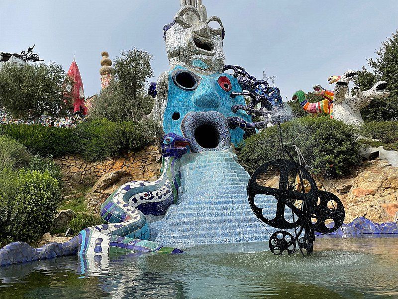
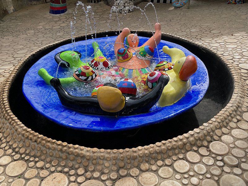
Giardino Dei Tarocchi, Strada Garavicchio, Pescia Fiorentina, Grosseto, Italien
An experience to visit this park and former residence of the artist Niki de Saint Phalle
Str. Garavicchio, 2, 58011 Pescia Fiorentina GR, Italien
42° 25' 33.3" N 11° 28' 0.3" E
42.4259035 11.4667417
• Head toward Strada Garavicchio. Go for 182 m.
• Turn left onto Strada Garavicchio. Go for 191 m.
• Turn right onto Strada Pescia Fiorentina Chiarone (SP75). Go for 1.3 km.
• Take ramp onto Via Aurelia (SS1). Go for 14.3 km.
• Take ramp toward Montalto di C./Canino/Tuscania/Viterbo. Go for 168 m.
• Turn left onto Strada Statale Castrense (SS312) toward Montalto di Castro/Tuscania/Viterbo. Go for 3.8 km.
• Take the 2nd exit from roundabout onto Strada Statale Castrense (SS312). Go for 2.5 km.
• Turn left onto Strada Provinciale Doganella (SP106). Go for 5.9 km.
• Turn left onto Strada Provinciale dell'Abbadia (SP107). Go for 1.2 km.
• Turn right. Go for 650 m.
• Arrive at your destination on the right.
☍
30,3 km
( 24 min.)
Day
Day
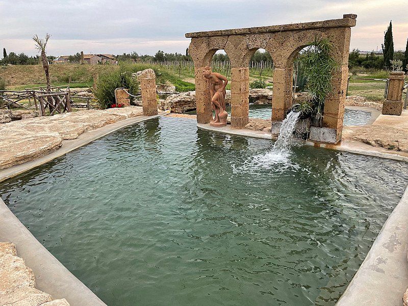
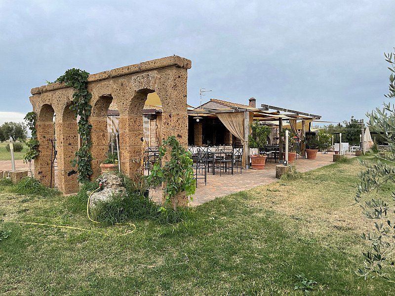
Resort Fonte Vulci / Agriturismo, Canino, Viterbo, Italien
At 52 euros per day for a simple pitch, this agritourism is well above our pain threshold. We have afforded ourselves the "luxury" for 2 days.
The thermal pools, which can be used free of charge, and the excellent restaurant, which cooks according to Etruscan recipes, made up for the "price shock" somewhat. In the evening, a noticeable number of guests from around Rome came to the restaurant.
On the 2nd day we visited the nearby remains of the Etruscan city of Vulci.
Vulci, Loc. Monte dell'Oro, snc, 01011 Canino VT, Italien
42° 26' 14.6" N 11° 38' 52.1" E
42.4373921 11.6478020
• Head toward Strada Provinciale dell'Abbadia. Go for 650 m.
• Turn left onto Strada Provinciale dell'Abbadia (SP107). Go for 1.2 km.
• Turn left onto Strada Provinciale Doganella (SP106). Go for 16.6 km.
• Continue on SP106. Go for 14 m.
• Continue on Viale Caduti sul Lavoro (SP106). Go for 278 m.
• Turn right onto Via Salvo D'Acquisto (SP47). Go for 4.4 km.
• Turn left onto Strada Statale Castrense (SS312). Go for 9.5 km.
• Turn right onto Località Cantoniera (SS74). Go for 972 m.
• Turn right onto Strada Provinciale di Gradoli (SP145). Go for 1.5 km.
• Continue on Via Piave. Go for 263 m.
• Continue on Via Indipendenza. Go for 74 m.
• Turn left onto Via Roma. Go for 377 m.
• Continue on Strada Provinciale di Gradoli (SP145). Go for 4.9 km.
• Turn right onto Strada Regionale Cassia (SR2). Go for 6.3 km.
• Turn right onto Viale Cristoforo Colombo. Go for 452 m.
• Turn right onto Viale Armando Diaz. Go for 203 m.
• Arrive at Viale Armando Diaz. Your destination is on the right.
☍
47,6 km
( 45 min.)
Day
Day
Day
Day
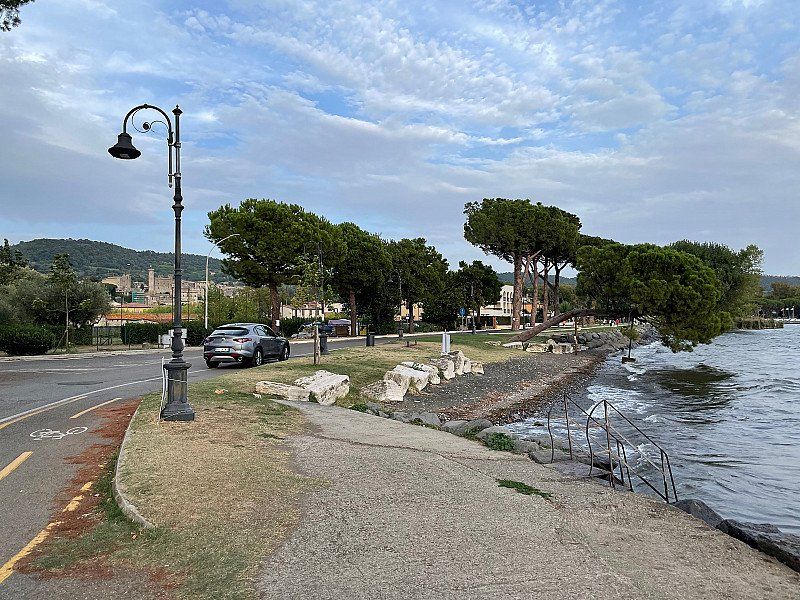
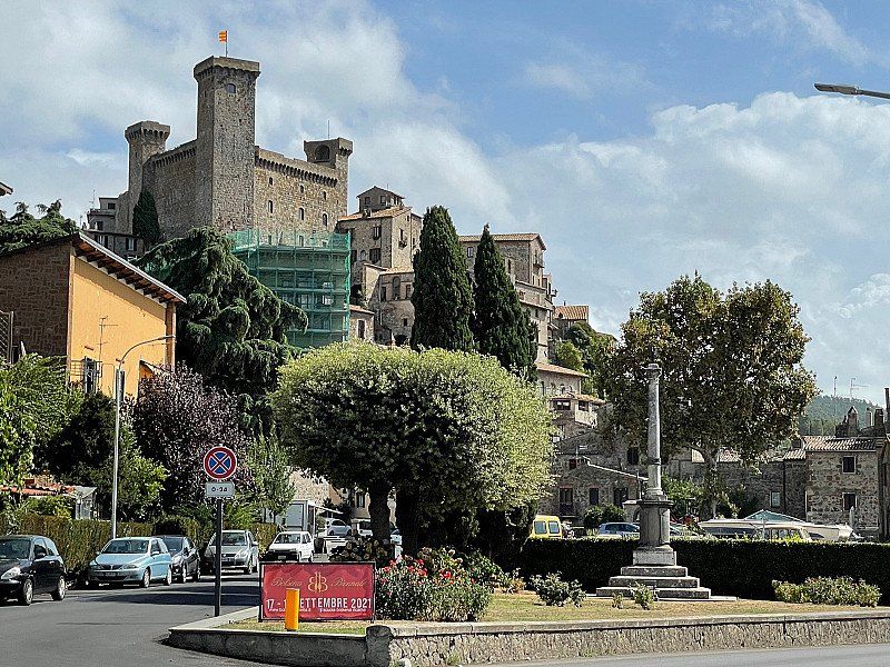
Camping Pineta
The campsite is on the lake. A visit to the medieval old town of Bolsena is a must. Good restaurants can be found by the lake and in the city.
Viale Armando Diaz 48, 01023, Bolsena, Italy
42° 38' 39.2" N 11° 58' 36.4" E
42.6442100 11.9767900
• Head east on Viale Armando Diaz. Go for 203 m.
• Turn left onto Viale Cristoforo Colombo. Go for 452 m.
• Turn right onto Via Cassia Nord (SR2). Go for 14.1 km.
• Keep right onto Via Cassia toward Viterbo. Go for 1.0 km.
• Keep left onto Via Casa Vecchia. Go for 217 m.
• Turn right onto Strada Regionale Cassia (SR2). Go for 12.7 km.
• Take the 2nd exit from roundabout onto Via Cassia (SR2). Go for 503 m.
• Take ramp onto Strada Statale Umbro-Laziale (SS675) toward Orte/Milano-Napoli/A1. Go for 26.7 km.
• Take ramp toward Firenze/Roma. Go for 672 m.
• Continue on Via Terni. Go for 256 m.
• Turn right toward Autostrada del Sole/A1. Go for 121 m.
• Take ramp onto A1 (Autostrada del Sole) toward Roma. Go for 247 km.
• Take the exit toward Salerno/Reggio Calabria/A3/Avellino/A16/Bari/A14 onto A30 (Autostrada Caserta-Salerno). Go for 30.9 km.
• Take the exit toward Palma/Campania. Go for 1.4 km.
• Keep left toward Angri/SS268/S. Giuseppe V. Go for 129 m.
• Take ramp onto Strada Statale del Vesuvio (SS268) toward Angri. Go for 5.8 km.
• Take ramp toward Poggiomarino/Caserta-Salerno/A30. Go for 270 m.
• Continue on Via Passanti Flocco. Go for 2.4 km.
• Take the 1st exit from roundabout onto Via Passanti. Go for 248 m.
• Turn left onto Via Parrella. Go for 815 m.
• Continue on Via Nolana. Go for 892 m.
• Turn right onto Via Parrelle Civita Giuliana. Go for 263 m.
• Arrive at Via Parrelle Civita Giuliana. Your destination is on the left.
☍
347,4 km
(3 hrs. 11 min.)
Day
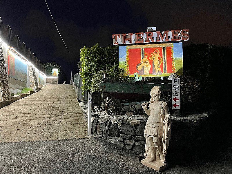
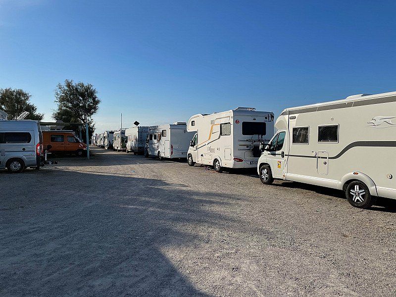
Area di sosta camper "La Terrazza di Hermès"
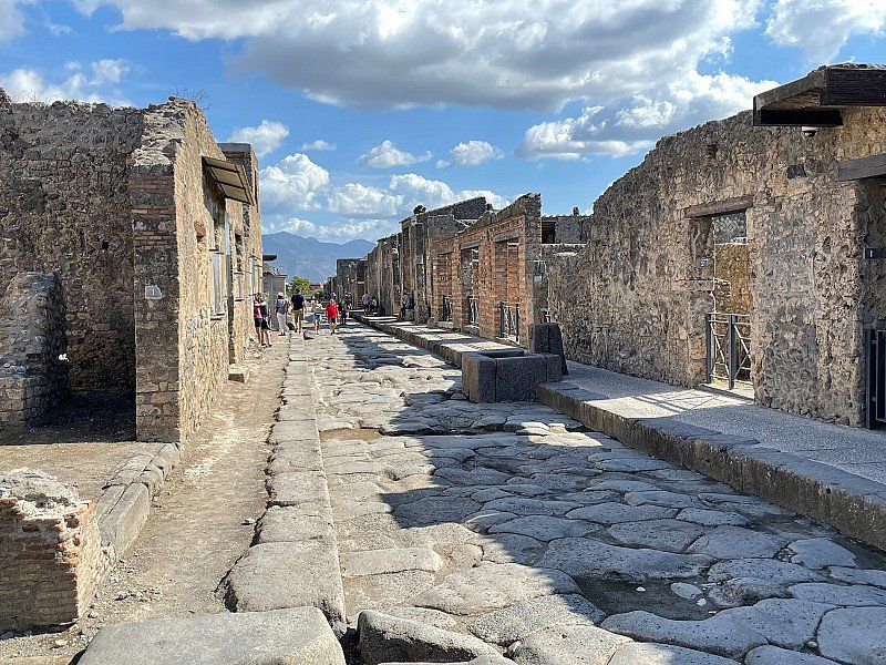
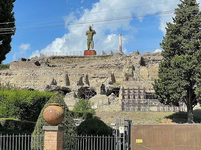
The SP with a view of Mount Vesuvius is well suited for visiting the ruined city of Pompei. You can walk to an entrance in around 20-25 minutes.
Via Parrelle Civita Giuliana, 27, 80045 Pompei NA, Italien
40° 45' 39.1" N 14° 29' 32.4" E
40.7608724 14.4923328
• Head toward Via Nolana on Via Parrelle Civita Giuliana. Go for 263 m.
• Turn right onto Via Nolana. Go for 1.3 km.
• Continue on Via Albenzio De Fusco. Go for 116 m.
• Turn right onto Via Piave. Go for 106 m.
• Turn left onto Via Lepanto. Go for 358 m.
• Take the 2nd exit from roundabout onto Via Lepanto. Go for 628 m.
• Take the 1st exit from roundabout onto Via Acquasalsa toward Napoli/A3/Salerno. Go for 89 m.
• Take the 2nd exit from roundabout onto Via Acquasalsa toward A3/Napoli/Salerno. Go for 286 m.
• Take left ramp onto A3 (Autostrada Napoli-Salerno) toward Salerno. Go for 28.5 km.
• Take the exit toward Tangenziale/Salerno Centro/Ospedale/Fratte. Go for 428 m.
• Keep right toward Ospedale/Tangenziale/SS18/Pontecagnano. Go for 205 m.
• Continue on Tangenziale (SS18). Go for 8.0 km.
• Take ramp onto Via Roberto Wenner toward Stadio Arechi/Giffoni V.P. Go for 720 m.
• Take the 2nd exit from roundabout onto Via Roberto Wenner toward Centro. Go for 301 m.
• Take the 2nd exit from roundabout. Go for 290 m.
• Continue straight ahead. Go for 44 m.
• Take the 2nd exit from roundabout. Go for 605 m.
• Continue toward Via Salvador Allende/SP175. Go for 68 m.
• Take the 2nd exit from roundabout onto Via Salvador Allende (SP175). Go for 4.5 km.
• Arrive at Via Lago Trasimeno (SP175). Your destination is on the right.
☍
46,8 km
( 37 min.)
Day
Camping Lido Di Salerno, Via Lago Trasimeno, Pontecagnano Faiano, Salerno, Italien
We drove to this place based on positive reviews. We didn't like it. Apart from the overcrowding and narrow spaces, the sanitary facilities are old and worn out.
The nearby Amalfi Coast is probably one of the reasons for the large number of visitors. In addition, many other campsites were already closed.
Via Lago Trasimeno, 84098 Pontecagnano Faiano SA, Italien
40° 35' 43.7" N 14° 52' 14.3" E
40.5954649 14.8706269
• Head southeast on Via Lago Trasimeno (SP175). Go for 1.9 km.
• Continue on Via Litoranea Salerno-Paestum (SP175a). Go for 7.2 km.
• Take the 2nd exit from roundabout onto Via Gino Birindelli (SP175). Go for 5.9 km.
• Turn right onto Via Foce Sele. Go for 569 m.
• Turn right. Go for 36 m.
• Arrive at your destination on the right.
☍
15,6 km
( 14 min.)
Day
Day
Day
Day
Area Sosta La Foce dei Tramonti
Cozy campsite on the coast and the mouth of the Sele River. Ideal for canoeists.
The Greek temples in nearby Paestum are easy to get to by bike.
Via Foce Sele 1, 84063, Paestum, Italy
40° 28' 51" N 14° 56' 42" E
40.4808333 14.9450000
• Head southeast. Go for 110 m.
• Continue on Via Foce Sele. Go for 495 m.
• Turn right onto Via Foce Sele (SP175). Go for 2.1 km.
• Take the 3rd exit from roundabout onto Via Foce Sele (SP175). Go for 608 m.
• Turn right onto Via Francesco Gregorio (SP175). Go for 3.5 km.
• Take the 3rd exit from roundabout onto Via Laura (SP175). Go for 1.8 km.
• Take the 2nd exit from roundabout onto Via Tavernelle (SP175). Go for 375 m.
• Turn right onto Via Magna Grecia. Go for 329 m.
• Arrive at Via Magna Grecia.
☍
9,4 km
( 11 min.)
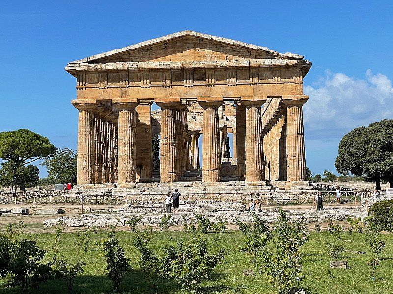
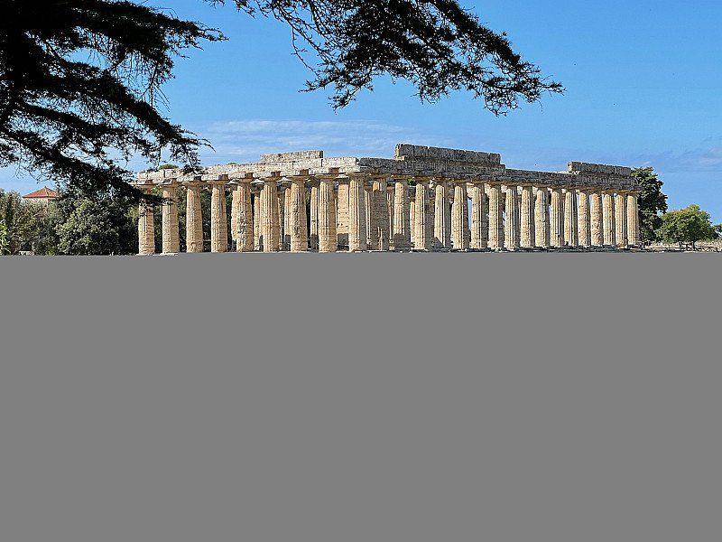
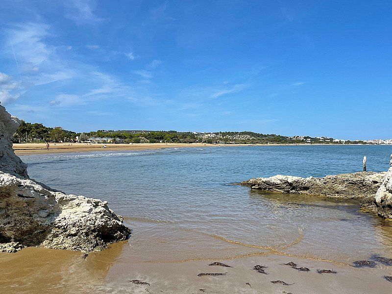
Paestum, Salerno, Italien
The temple complexes should be seen. We looked at the facility outside the fence. If you want to know more about it, you have to pay admission
84047 Paestum, Salerno, Italien
40° 25' 23.3" N 15° 0' 25.8" E
40.4231513 15.0071628
• Head north on Via Magna Grecia. Go for 329 m.
• Continue on Via Magna Grecia (SP276). Go for 3.3 km.
• Take the 2nd exit from roundabout onto Via Magna Grecia (SP276). Go for 1.7 km.
• Take the 3rd exit from roundabout onto Via Sabatella (SS18). Go for 2.8 km.
• Pass 2 roundabouts and continue on Viale Eburum (SS18). Go for 6.7 km.
• Take the 1st exit from roundabout onto Località Cioffi (SS18) toward A3/Reggio Calabria/Salerno/Battipaglia. Go for 1.5 km.
• Pass 5 roundabouts and continue on Strada Statale Tirrena Inferiore (SS18). Go for 4.7 km.
• Take the 2nd exit from roundabout onto Strada Statale Tirrena Inferiore (SS18) toward Salerno/A3/Reggio C. Go for 287 m.
• Pass 2 roundabouts and continue on Strada Statale Tirrena Inferiore (SS18). Go for 1.0 km.
• Take left ramp onto A2 (Autostrada del Mediterraneo) toward Salerno. Go for 21.2 km.
• Continue on A3 (Autostrada Salerno-Reggio Calabria) toward Salerno/Napoli. Go for 2.7 km.
• Take the right exit toward Salerno. Go for 21 m.
• Turn left onto Via Fra' Generoso. Go for 973 m.
• Continue on Via Giuseppe Paesano. Go for 43 m.
• Turn left onto Via Alfonso Gatto toward Napoli/SS18. Go for 999 m.
• Turn right onto Strada Regionale Tirrena Inferiore (SR18). Go for 53 m.
• Turn left onto Strada Regionale Tirrena Inferiore (SR18). Go for 1.6 km.
• Turn slightly left onto SS163. Go for 20.3 km.
• Enter the roundabout. Go for 82 m.
• Arrive at Piazza Flavio Gioia. Your destination is on the right.
☍
70,2 km
(1 hrs. 22 min.)
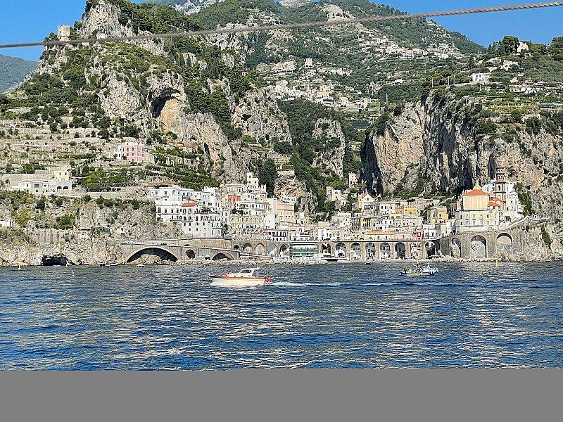
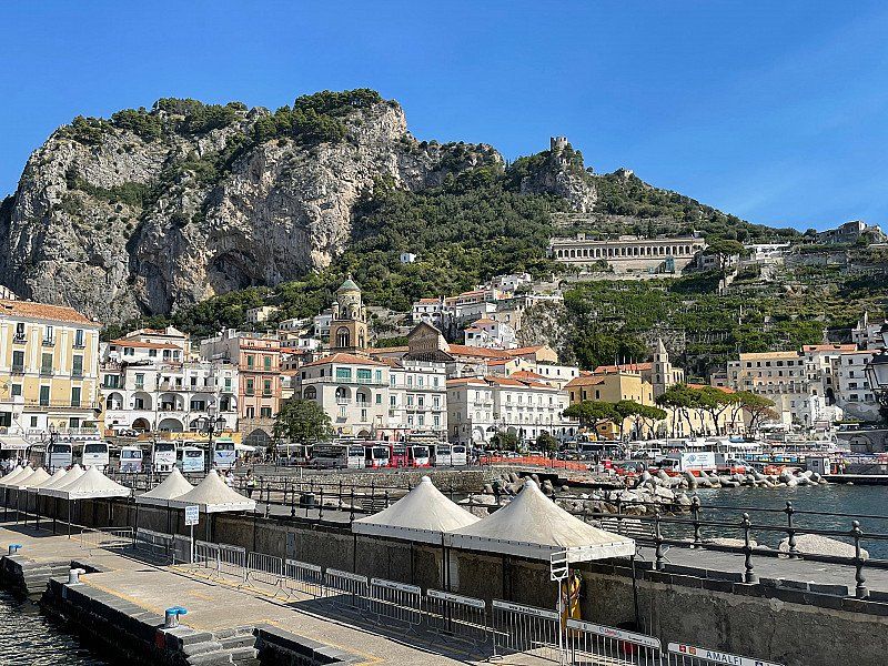
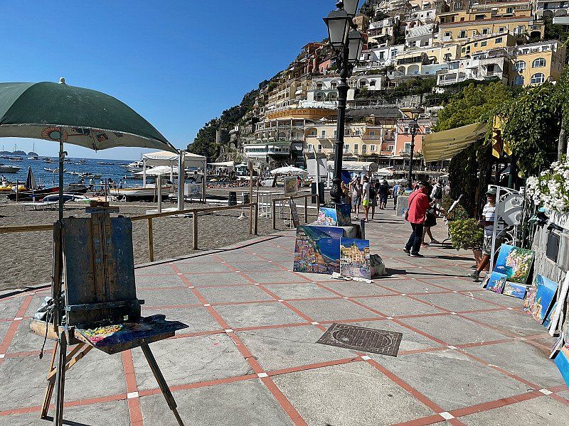
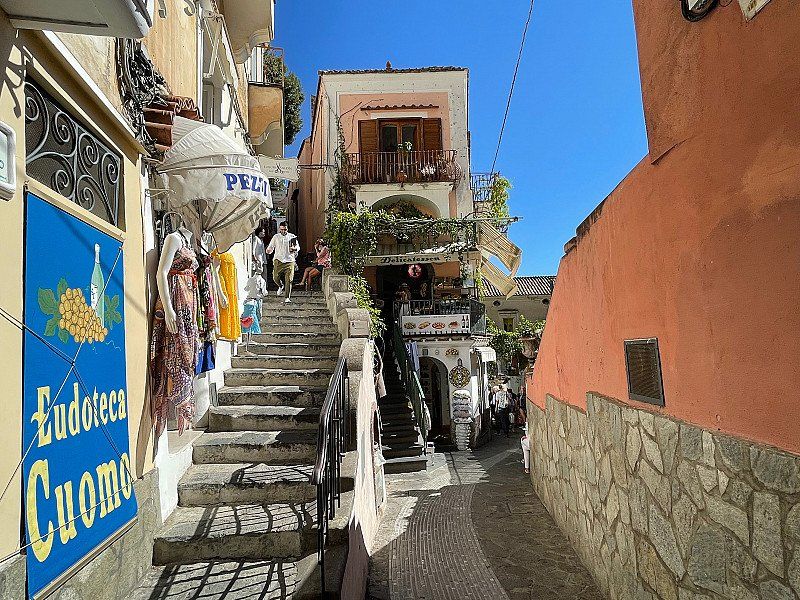
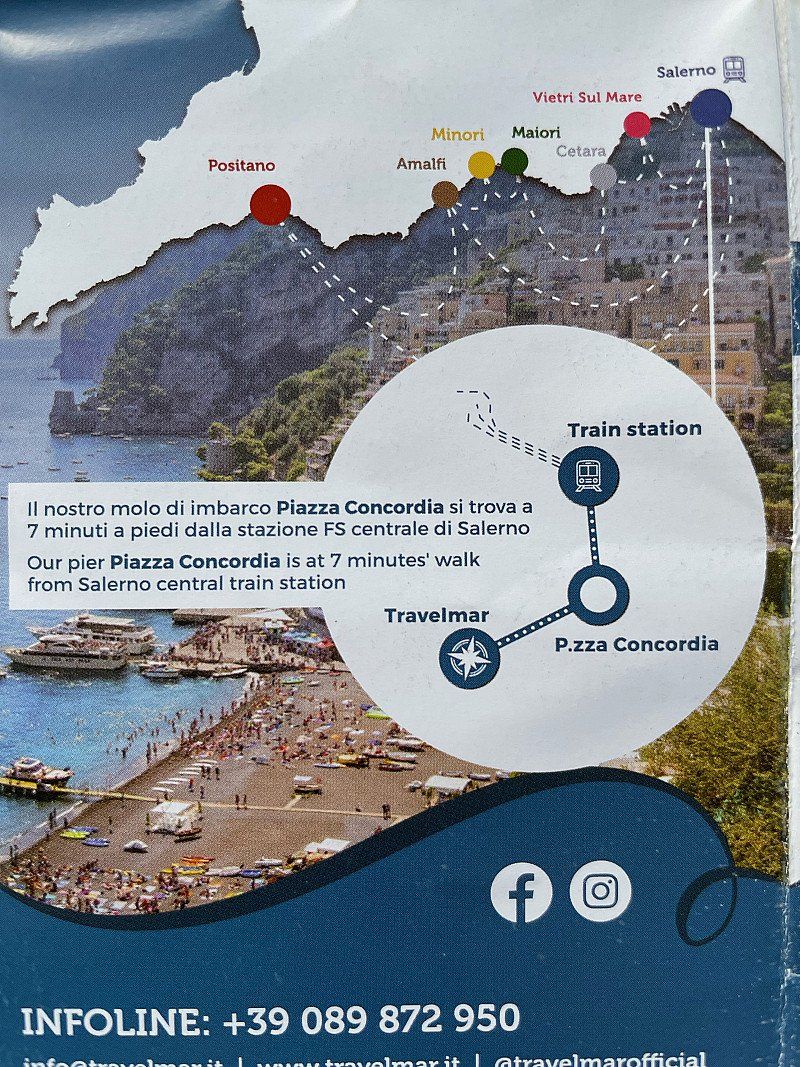
Amalfiküste, Amalfi, Salerno, Italien
With a rental car we drove from the campsite to Salerno. We took the ferry to Positano via the Amalfi station. What can I say: You have to see it. It's just very touristy.
84011 Amalfi, Salerno, Italien
40° 38' 0" N 14° 36' 10.4" E
40.6333389 14.6028963
• Follow the roundabout. Go for 29 m.
• Take the 1st exit from roundabout onto Corso Delle Repubbliche Marinare (SS163). Go for 20.3 km.
• Continue on Via Roma (SR18). Go for 1.6 km.
• Turn right onto Strada Regionale Tirrena Inferiore (SR18). Go for 53 m.
• Turn left onto Via Alfonso Gatto (SR18) toward Autostrade. Go for 999 m.
• Turn right onto Via Giuseppe Paesano. Go for 43 m.
• Continue on Via Fra' Generoso. Go for 983 m.
• Turn right and take ramp onto A3 (Autostrada Salerno-Reggio Calabria). Go for 2.7 km.
• Continue on A2 (Autostrada del Mediterraneo) toward Reggio Calabria. Go for 49.6 km.
• Take the exit toward Potenza/Sicignano onto RA5 (Raccordo Autostradale Scalo Sicignano-Potenza). Go for 52.5 km.
• Keep left onto SS7 toward Foggia/SS658/Matera/SS407. Go for 1.8 km.
• Keep left onto Strada Statale Basentana (SS407) toward Matera/Metaponto/SS106/Melfi/SS658. Go for 66.4 km.
• Take ramp onto SS7racc toward Matera/Bari/Altamura. Go for 8.4 km.
• Continue on Via Appia (SS7). Go for 19.4 km.
• Take ramp onto Via Appia (SS7) toward Taranto/Santeramo/Matera Nord. Go for 1.3 km.
• Take the 2nd exit from roundabout onto Via Appia (SS7) toward Autostrada/Taranto. Go for 2.3 km.
• Turn left onto Strada Provinciale Matera Gioia del Colle toward Gioia del Colle. Go for 23 m.
• Turn left onto Contrada Pedale della Madonna. Go for 284 m.
• Arrive at Contrada Pedale della Madonna. Your destination is on the right.
☍
228,7 km
(2 hrs. 43 min.)
Day
Day
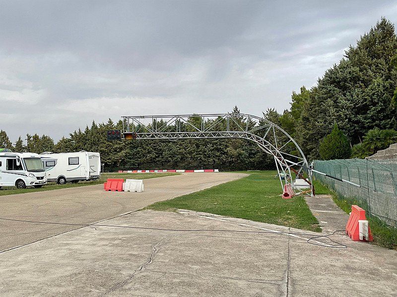
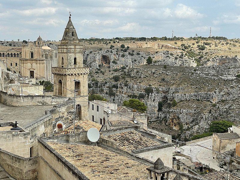
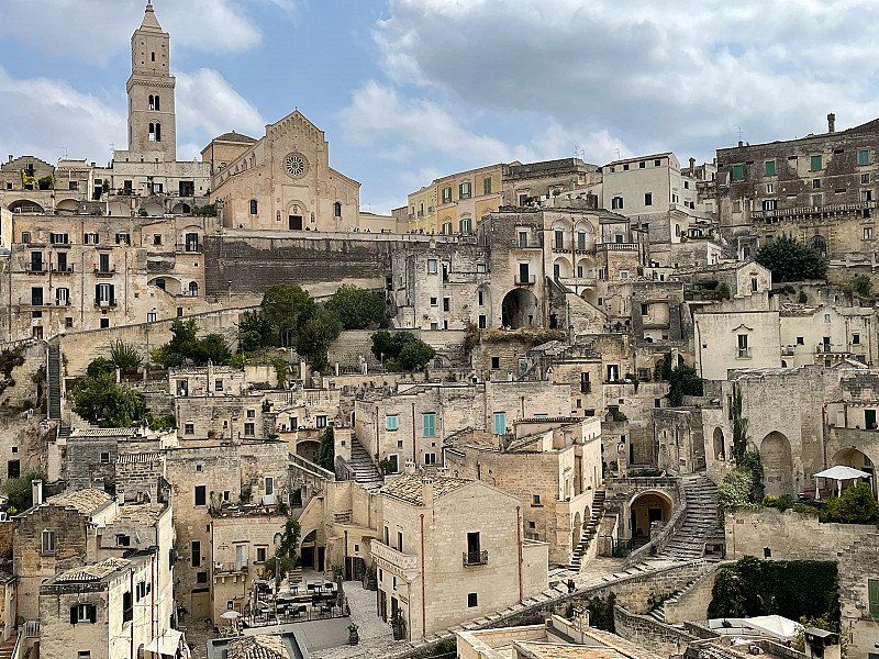
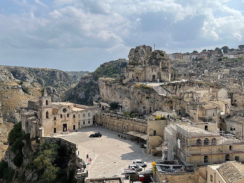
Matera SP auf einer stillgelegten Kartbahn
Matera with its former cave dwellings (called Sassi) is a must when traveling through Basilicata. This city has an enormous charisma. Even James Bond apparently couldn't resist and parts of the film "No Time to Die" were filmed in Matera.
The SP on the closed kart track was great. The operator has set up a free shuttle service for visiting the city.
SS7, 150, 75100 Matera MT, Italien
40° 40' 48" N 16° 37' 27.8" E
40.6800136 16.6243861
• Head east on Contrada Pedale della Madonna. Go for 284 m.
• Turn right onto Strada Provinciale Matera Gioia del Colle. Go for 23 m.
• Turn left onto Via Appia (SS7). Go for 25.5 km.
• Take the 2nd exit from roundabout onto SP23 toward Taranto/SS100/Bari/Autostrada. Go for 7.3 km.
• Turn left onto Contrada San Basilio (SS100) toward Bari/Gioia del Colle. Go for 3.3 km.
• Turn right onto Strada Provinciale per Castellaneta (SP116) toward Noci. Go for 2.6 km.
• Continue on Strada Provinciale Noci Verso Castellaneta (SP116). Go for 11.9 km.
• Turn left and take ramp onto Strada Provinciale delle Grotte (SP237). Go for 1.1 km.
• Continue on Strada Provinciale di Alberobello (SS377). Go for 10.4 km.
• Turn right onto Via 7 Liberatori della Selva (SS604) toward Mottola/Taranto/Monopoli/Bari. Go for 195 m.
• Take the 3rd exit from roundabout onto Via Giuseppe Capecelatro. Go for 334 m.
• Continue on Via Don Francesco Gigante. Go for 30 m.
• Take the 1st exit from roundabout onto Via Don Francesco Gigante. Go for 215 m.
• Turn right. Go for 20 m.
• Turn left. Go for 64 m.
• Arrive at your destination on the left.
☍
63,2 km
( 50 min.)
Day
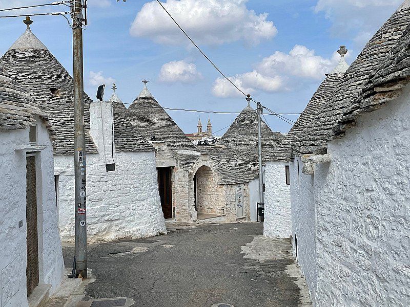
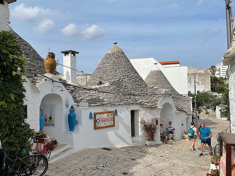
Area Sosta Alberobello
Here you can see the legendary Trulli houses. Very nice.
Via Cadore 2, 70011, Alberobello, Italy
40° 46' 58" N 17° 14' 2" E
40.7827778 17.2338889
• Head south. Go for 38 m.
• Turn right toward Via Don Francesco Gigante. Go for 132 m.
• Turn left onto Via Don Francesco Gigante. Go for 35 m.
• Turn right onto Largo Michelangelo la Sorte. Go for 112 m.
• Turn right onto Via Alessandro Manzoni. Go for 181 m.
• Continue on Via Cesare Battisti. Go for 210 m.
• Continue on Corso Trento e Trieste. Go for 260 m.
• Turn right onto Via Vittime del Fascismo. Go for 114 m.
• Turn sharp left onto Viale Bari. Go for 348 m.
• Continue on Viale Putignano. Go for 283 m.
• Continue toward Strada Statale dei Trulli/SS172. Go for 22 m.
• Take the 3rd exit from roundabout onto Strada Statale dei Trulli (SS172) toward Putignano/Bari. Go for 5.8 km.
• Take the 2nd exit from roundabout onto Strada Statale Putignano per Alberobello (SS172) toward Putignano/Turi. Go for 4.3 km.
• Continue toward Strada Provinciale Alberobello/SS172. Go for 58 m.
• Take the 2nd exit from roundabout onto Strada Provinciale Alberobello (SS172) toward Putignano/Turi. Go for 1.6 km.
• Take the 1st exit from roundabout toward Castellana G./Conversano/Turi/Bari/Ospedale. Go for 92 m.
• Continue on Via Martiri delle Foibe. Go for 187 m.
• Continue on Via Giambattista Carafa Bali. Go for 148 m.
• Take the 2nd exit from roundabout onto Viale Federico II. Go for 380 m.
• Continue on Viale Cavalieri di Malta. Go for 325 m.
• Continue on Viale della Libertà. Go for 142 m.
• Continue on Viale Tenente Pietro Sbiroli. Go for 144 m.
• Continue on Viale della Repubblica. Go for 520 m.
• Turn right onto Via Turi (SS172) toward Turi/Bari. Go for 2.9 km.
• Take the 2nd exit from roundabout onto SS172 toward Turi/Bari. Go for 6.5 km.
• Take the 3rd exit from roundabout onto Strada Provinciale Circonvallazione di Turi (SP215) toward Casamassima/Bari. Go for 4.5 km.
• Continue on SS172. Go for 5.7 km.
• Take middle ramp onto Strada Statale Bari Taranto (SS100) toward Bari. Go for 16.9 km.
• Take ramp onto Tangenziale di Bari (SS16) toward Foggia/Autostrade. Go for 7.3 km.
• Take ramp onto Via Bruno Buozzi toward Modugno/SS96. Go for 639 m.
• Continue on SS96. Go for 283 m.
• Keep left onto SS96. Go for 30.7 km.
• Take ramp toward Minervino M./SP234/Spinazzola/SP230. Go for 295 m.
• Take the 2nd exit from roundabout onto Strada Provinciale Ruvo di Puglia-Calendano (SP63) toward Minervino/SP234/Spinazzola/SP230. Go for 871 m.
• Continue on Strada Provinciale di Castel del Monte (SP234). Go for 3.9 km.
• Pass 2 roundabouts and continue on Strada Provinciale di Castel del Monte (SP234). Go for 12.1 km.
• Turn right onto SS170dir A. Go for 1.0 km.
• Turn left onto Via Castel del Monte (SP234a). Go for 921 m.
• Arrive at Via Castel del Monte (SP234a). Your destination is on the left.
☍
109,9 km
(1 hrs. 36 min.)
Day
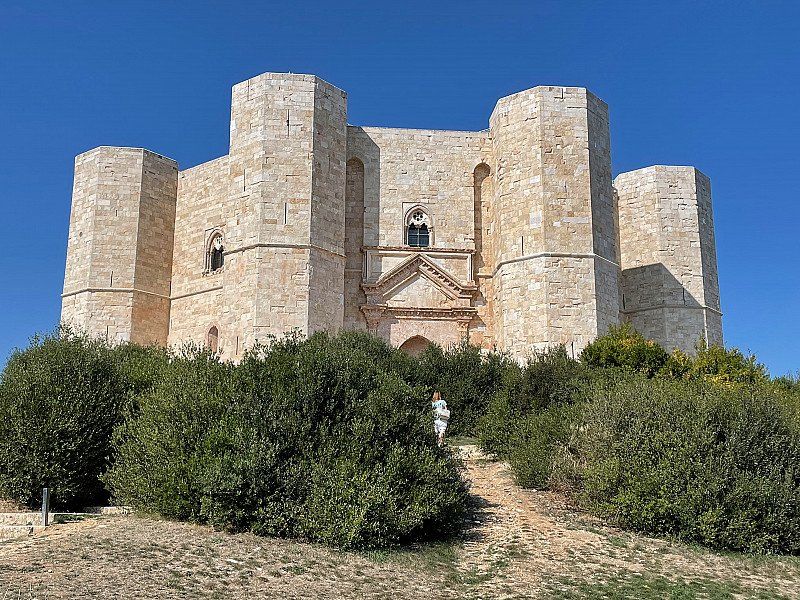
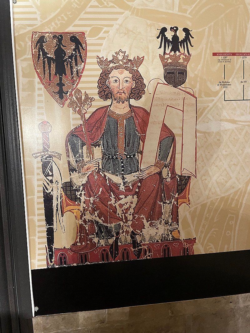
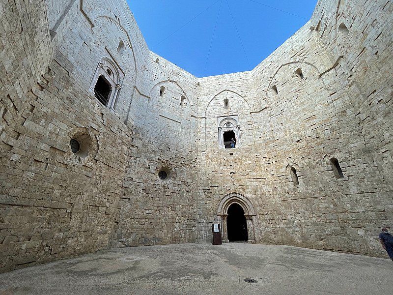
Castel del Monte, Strada Statale 170, Andria, Barletta-Andria-Trani, Italien
If you like castles, this is the place for you. The building was built by Friedrich II, a grandson of Barbarossa. Why and for what purpose is largely unknown. In any case, it is very worth seeing.
Contrada Castel del Monte Ex, Strada Statale 170, 76123 Andria BT, Italien
41° 5' 5.2" N 16° 16' 15.4" E
41.0847664 16.2709360
• Head west on Via Castel del Monte (SP234a). Go for 921 m.
• Turn right onto SS170dir A. Go for 900 m.
• Arrive at SS170dir A.
☍
1,8 km
( 3 min.)
Parcheggio Chiesa Santa Maria del Monte
SP to visit the Castel del Monte.
From there a shuttle bus goes to the castle and back.
SS170dir, 76123 Andria BT, Italien
41° 4' 32.2" N 16° 16' 28.9" E
41.0756025 16.2746841
• Head south on SS170dir A. Go for 104 m.
• Turn right onto SP234. Go for 4.2 km.
• Turn right onto Contrada Piano di Citulo (SP149) toward Montegrosso/SP43. Go for 1.6 km.
• Continue on SP149. Go for 8.2 km.
• Continue on Contrada Lama di Corvo (SP149). Go for 1.3 km.
• Continue on Contrada Iazzo Nuovo (SP149). Go for 3.2 km.
• Continue on SP149. Go for 2.5 km.
• Continue on Viale dei Condottieri (SP149). Go for 421 m.
• Continue on SP149. Go for 1.7 km.
• Take the 2nd exit from roundabout onto SS98 (SP231). Go for 2.8 km.
• Take ramp onto SR6. Go for 5.1 km.
• Take ramp onto SS93. Go for 586 m.
• Turn left and take ramp onto A14 (Autostrada Adriatica) toward Pescara. Go for 21.6 km.
• Take the exit toward Cerignola Est/Mattinata/Vieste/Pugnochiuso/Trinitapoli/Margherita di Savoia/Manfredonia. Go for 894 m.
• Turn left onto Strada Statale Rivolese (SS545) toward Manfredonia. Go for 3.3 km.
• Pass 2 roundabouts and continue on Strada Statale Rivolese (SS545). Go for 15.9 km.
• Continue on Strada Statale delle Salline per Manfredonia Corso (SS159) toward Monte San'Angelo. Go for 4.9 km.
• Take the 2nd exit from roundabout onto SP141. Go for 8.3 km.
• Turn left toward Viale Giuseppe Di Vittorio. Go for 61 m.
• Continue on SS89. Go for 887 m.
• Take ramp onto SS89 toward Mattinata/Vieste/San Giovanni R./Monte San'Angelo. Go for 9.8 km.
• Pass 2 roundabouts and continue on SS89. Go for 12.1 km.
• Turn right onto SS89 toward Mattinata. Go for 519 m.
• Keep right onto SP53. Go for 1.2 km.
• Turn right onto Strada Provinciale Mattinata Vieste (SP53) toward Vieste Litoranea. Go for 9.1 km.
• Turn right toward Strada Provinciale Mattinata Vieste/SP53. Go for 50 m.
• Continue on Strada Provinciale Mattinata Vieste (SP53). Go for 31.3 km.
• Turn right onto Via Madonna della Libera. Go for 251 m.
• Turn left onto Viale 24 Maggio. Go for 21 m.
• Turn right onto Via Milano. Go for 11 m.
• Arrive at Via Milano. Your destination is on the right.
☍
152,0 km
(2 hrs. 12 min.)
Day
Day
Day
Day
Day
Day
Day
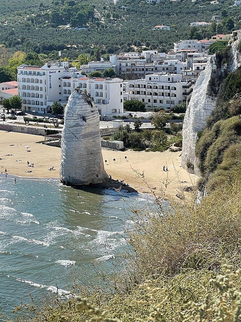
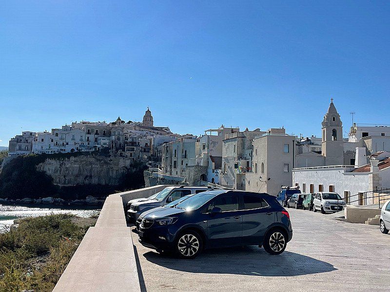
Vieste, Foggia, Italien
Vieste is a very popular travel destination on the Gargano. A whole bunch of CP / SP and restaurants await guests. In autumn, however, the offer is reduced considerably. At the beginning of October almost all restaurants on the beaches close and you can only find open restaurants in the city center.
71019 Vieste, Foggia, Italien
41° 52' 56.9" N 16° 10' 36.3" E
41.8824764 16.1767489
• Head toward Via Papa Giovanni XXIII on Via Milano. Go for 43 m.
• Turn left onto Via Papa Giovanni XXIII. Go for 33 m.
• Turn right onto Via Trieste. Go for 75 m.
• Turn right onto Via Santa Maria di Merino. Go for 34 m.
• Turn right onto Via Vittorio Veneto. Go for 106 m.
• Turn right onto Viale 24 Maggio. Go for 300 m.
• Take the 1st exit from roundabout onto Via Guglielmo Marconi. Go for 53 m.
• Continue on Via Dante Alighieri. Go for 1.0 km.
• Continue on Località Pietà. Go for 20 m.
• Keep right onto SS89 toward Ospedale/Peschici Litoranea/Rodi G.Co/Autostrada. Go for 8.8 km.
• Continue on Cascina Mandrione (SS89). Go for 266 m.
• Continue on SS89 toward Peschici/Rodi Garganico. Go for 10.5 km.
• Take the 3rd exit from roundabout onto SS89 toward Autostrada/Foggia. Go for 2.6 km.
• Turn right onto SS89. Go for 6.4 km.
• Turn left onto SP528 toward Vico G.Co/Ischitella/Foggia/Autostrada. Go for 5.7 km.
• Continue on SP144. Go for 71 m.
• Continue on SP528. Go for 336 m.
• Turn right onto Strada Scorrimento Veloce del Gargano. Go for 8.3 km.
• Keep right onto Strada Scorrimento Veloce del Gargano toward Bologna-Bari/A14/Foggia. Go for 52.0 km.
• Take the 2nd exit from roundabout onto A14 (Autostrada Adriatica) toward Bologna-Bari/Pescara. Go for 207 km.
• Take the exit toward Grottammare/Grottammare Centro/SS16/S. Benedetto D. T./Cupra M./Acquaviva P. Go for 712 m.
• Turn left toward Viale della Fratellanza. Go for 208 m.
• Continue on Viale della Fratellanza. Go for 460 m.
• Take the 3rd exit from roundabout toward Grottammare Centro. Go for 142 m.
• Continue on Via Gian Lorenzo Bernini (SS16). Go for 6.3 km.
• Turn left onto Strada Provinciale Valmenocchia (SP91) toward Montalto M./Cossignano/Carassai/Ripatransone/Montefiore dell'Aso. Go for 1.2 km.
• Turn left. Go for 212 m.
• Arrive at your destination on the right.
☍
312,5 km
(3 hrs. 31 min.)
Day
SP Natur Amiga - Cupra Marittima, Italien
Small, beautiful place above Cupra Marittima. V / E, shower, everything is available
Via Piana Santi, 34, 63064 Cupra Marittima AP, Italien
43° 2' 2.6" N 13° 50' 28" E
43.0340641 13.8411212
• Head toward Via Fernando Santi. Go for 212 m.
• Turn right onto Via Fernando Santi (SP91). Go for 1.1 km.
• Continue toward Via Adriatica Nord/SS16. Go for 49 m.
• Turn left onto Via Adriatica Nord (SS16). Go for 7.2 km.
• Take the 2nd exit from roundabout onto Via Giuseppe Mazzini (SS16) toward Ancona. Go for 384 m.
• Take ramp onto A14 (Autostrada Adriatica) toward Ancona. Go for 289 km.
• Continue on A1 (Autostrada del Sole). Go for 86.0 km.
• Take the exit toward La Spezia/Parma Ovest onto A15 (Autostrada della Cisa). Go for 5.9 km.
• Take the exit toward Parma Ovest/Pontetaro onto SS9 (Via Emilia). Go for 1.5 km.
• Take the 3rd exit from roundabout onto Strada Provinciale per Busseto (SP11). Go for 882 m.
• Take the 1st exit from roundabout onto SP11 toward Fontevivo. Go for 478 m.
• Keep left onto Strada Provinciale per Busseto (SP11). Go for 73 m.
• Take the 2nd exit from Strada Provinciale per Busseto roundabout onto Strada Provinciale per Busseto (SP11). Go for 723 m.
• Take the 2nd exit from roundabout onto Strada Provinciale per Busseto (SP11). Go for 284 m.
• Take the 1st exit from roundabout onto Strada Rosi Bellena. Go for 1.2 km.
• Continue on Strada Rosi di Bellena. Go for 1.8 km.
• Take the 3rd exit from roundabout onto Strada Comunale Berettine. Go for 1.3 km.
• Take the 2nd exit from roundabout onto Strada Comunale Berettine. Go for 1.2 km.
• Take the 1st exit from roundabout onto Strada Comunale del Priobato. Go for 445 m.
• Arrive at Strada Comunale del Priobato. Your destination is on the right.
☍
399,3 km
(3 hrs. 32 min.)
Day
Area Parking Nord
Via XXIV Maggio, 43012, Fontanellato, Italy
44° 52' 41" N 10° 10' 11" E
44.8780556 10.1697222
• Head northeast on Strada Comunale del Priobato. Go for 367 m.
• Turn right onto Viale 5 Novembre (SP11). Go for 832 m.
• Turn left onto Viale 5 Novembre (SP44). Go for 3.2 km.
• Pass 2 roundabouts and continue on Viale Giacomo Matteotti (SP10). Go for 4.5 km.
• Take the 1st exit from Via Augusto Daolio roundabout onto Via 1 Maggio (SP10). Go for 643 m.
• Pass 3 roundabouts and continue on Strada Provinciale di Cremona (SP10). Go for 10.6 km.
• Turn right onto SP10. Go for 2.6 km.
• Continue on SP33. Go for 3.6 km.
• Continue toward SP33. Go for 34 m.
• Take the 2nd exit from roundabout onto SP33. Go for 5.1 km.
• Take the 2nd exit from roundabout onto SP33. Go for 7.2 km.
• Take the 1st exit from roundabout onto Strada Provinciale Padana Inferiore (SPEXSS10) toward Cicognolo Centro/Piadena/Mantova. Go for 6.0 km.
• Turn left onto SP11 toward Isola Dovarese/Asola/Brescia. Go for 4.8 km.
• Continue on SP2. Go for 8.1 km.
• Continue toward Tangenziale Nord Ovest/SP2. Go for 48 m.
• Take the 2nd exit from roundabout onto Tangenziale Nord Ovest (SP2). Go for 1.8 km.
• Take the 2nd exit from roundabout onto SP1. Go for 1.1 km.
• Take the 2nd exit from roundabout onto Via Mantova (SP1). Go for 4.7 km.
• Turn slightly left onto Viale dei Caduti (SP8). Go for 2.4 km.
• Take the 2nd exit from roundabout onto SP8. Go for 2.4 km.
• Take the 2nd exit from roundabout onto SP8. Go for 2.4 km.
• Take the 1st exit from roundabout onto Via D. Pesenti (SP8). Go for 2.0 km.
• Take the 2nd exit from roundabout onto Via Repubblica (SP8). Go for 2.9 km.
• Continue toward Strada Crocevia/SP8. Go for 43 m.
• Take the 2nd exit from roundabout onto Strada Crocevia (SP8) toward Brescia/Mantova/Castiglione D/S/Guidizzolo. Go for 266 m.
• Take the 2nd exit from roundabout onto SP8 toward San Cassiano/Solferino/Cavriana. Go for 2.9 km.
• Continue on Via Pozzone (SP13). Go for 110 m.
• Turn left onto Via Monte Alto (SP8). Go for 1.4 km.
• Take the 1st exit from roundabout. Go for 1.2 km.
• Continue toward Strada Cavallara. Go for 42 m.
• Take the 2nd exit from roundabout onto Strada Cavallara. Go for 1.8 km.
• Continue on Via Cavallara (SP15). Go for 5.0 km.
• Take the 3rd exit from roundabout onto Strada dei Colli (SP19) toward Autostrada/A4/Monzambano/Ponti sul Mincio/Peschiera D/G/Verona. Go for 4.2 km.
• Turn right onto Via San Martino e Solferino. Go for 218 m.
• Turn left onto Via 1 Maggio. Go for 114 m.
• Turn right onto Via Generale Vittorio Darra. Go for 161 m.
• Turn left onto Via degli Alpini. Go for 46 m.
• Turn left onto Via degli Alpini. Go for 170 m.
• Arrive at your destination on the right.
☍
94,9 km
(1 hrs. 27 min.)
Day
Day
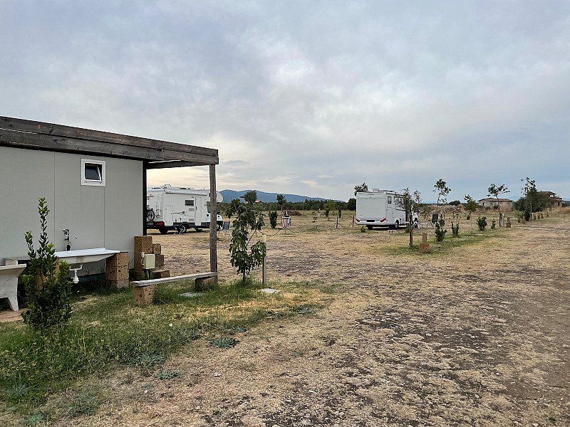
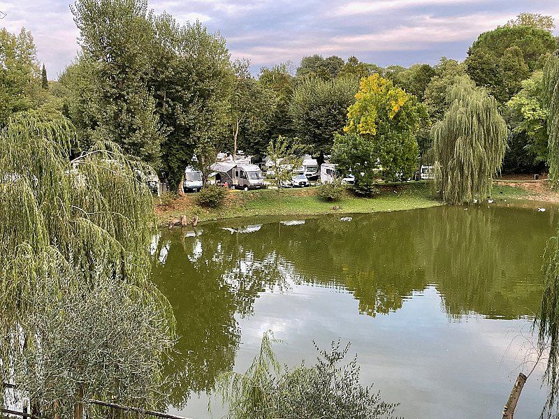
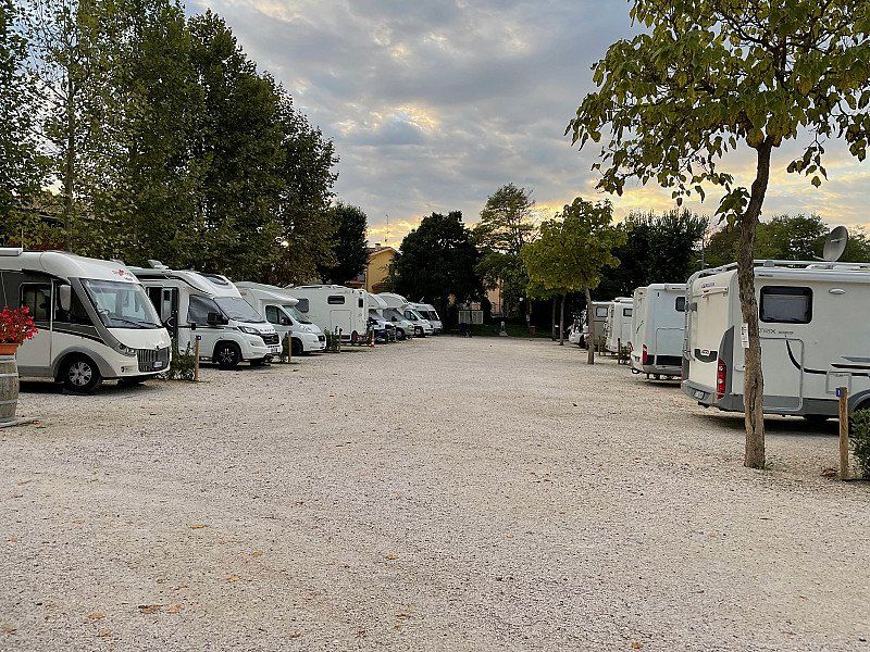
Area di sosta Monzambano
We approached this place near Lake Garda. It was created in a former gravel pit. A small pond complements the facility. The place is apparently popular and a lot of Italians go there on weekends. The area is ideally explored by bike and there is a lot to see. Along the river Mincio one comes Inn the worth seeing Borghetto.
Other destinations: Castellaro Lagusello and of course Lake Garda.
Via Generale V. Darra, 38C, 46040 Monzambano MN, Italien
45° 23' 23.2" N 10° 41' 34.5" E
45.3897745 10.6929186
• Head toward Via Generale dall'Ora. Go for 505 m.
• Turn slightly left onto Via Generale dall'Ora. Go for 130 m.
• Turn sharp left onto Strada dei Colli (SP19). Go for 4.9 km.
• Take the 3rd exit from roundabout onto Via Cavallara (SP15) toward Borghetto/Valeggio S/M/Villaftanca. Go for 326 m.
• Continue on Strada Tononi (SP15). Go for 910 m.
• Continue on SP3. Go for 1.2 km.
• Continue on Via Cavallara (SP3). Go for 447 m.
• Continue on SP3. Go for 328 m.
• Continue on Via Monte Borghetto (SP3). Go for 63 m.
• Turn sharp right onto SP55 toward Volta Mantovana/Ariano. Go for 128 m.
• Turn left onto Via Michelangelo Buonarroti. Go for 182 m.
• Turn left onto Via Giotto. Go for 152 m.
• Turn right onto Via Giotto. Go for 190 m.
• Arrive at Via Giotto. Your destination is on the left.
☍
9,4 km
( 11 min.)
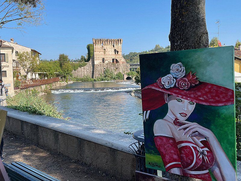
Cascate del Mincio
Nice excursion destination to Borghetto.
Via Giotto, 2, 37067 Valeggio sul Mincio VR, Italien
45° 21' 14.3" N 10° 43' 26.6" E
45.3539774 10.7240510
• Head south on Via Giotto. Go for 41 m.
• Continue on Via Michelangelo Buonarroti. Go for 32 m.
• Continue on Via Leonardo da Vinci. Go for 661 m.
• Turn left onto Via Michelangelo Buonarroti. Go for 182 m.
• Turn right onto SP55. Go for 131 m.
• Turn sharp left onto Via Monte Borghetto (SP3) toward Solferino/Castiglione D/S/Cavriana. Go for 107 m.
• Continue on SP3. Go for 328 m.
• Continue on Via Cavallara (SP3). Go for 447 m.
• Continue on SP3. Go for 1.2 km.
• Continue on Strada Tononi (SP3). Go for 910 m.
• Continue on Via Cavallara (SP15). Go for 248 m.
• Take the 2nd exit from roundabout onto Via Cavallara (SP15) toward Castellaro Lagusello/Cavriana/Solferino/Castiglione D/S/Brescia. Go for 3.0 km.
• Turn right toward SP18. Go for 57 m.
• Continue on Strada Primavera (SP18). Go for 801 m.
• Continue on Strada Nuova Italia (SP18). Go for 1.2 km.
• Turn left onto Strada Nuova Italia. Go for 132 m.
• Continue on Strada Castellaro Nuova Italia. Go for 249 m.
• Continue on Piazza Generale Orlandi. Go for 11 m.
• Continue on Via Castello Castellaro. Go for 218 m.
• Turn right onto Via Castello Castellaro. Go for 99 m.
• Arrive at Via Castello Castellaro. Your destination is on the right.
☍
10,1 km
( 11 min.)
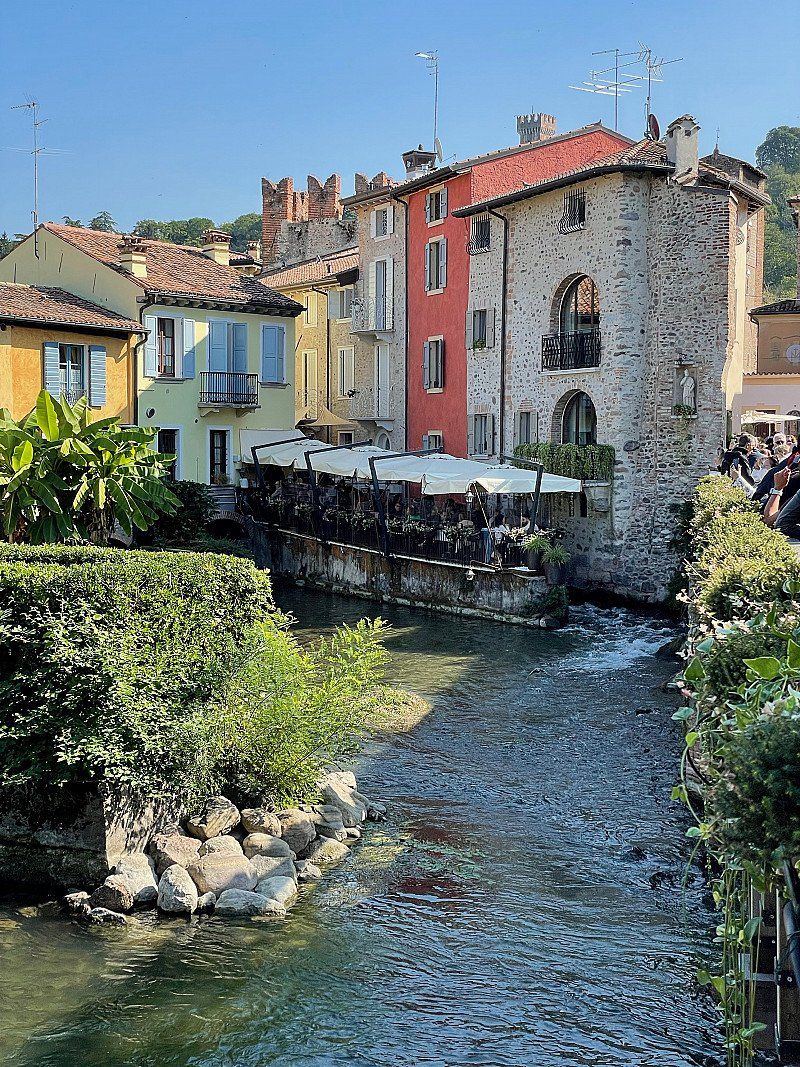
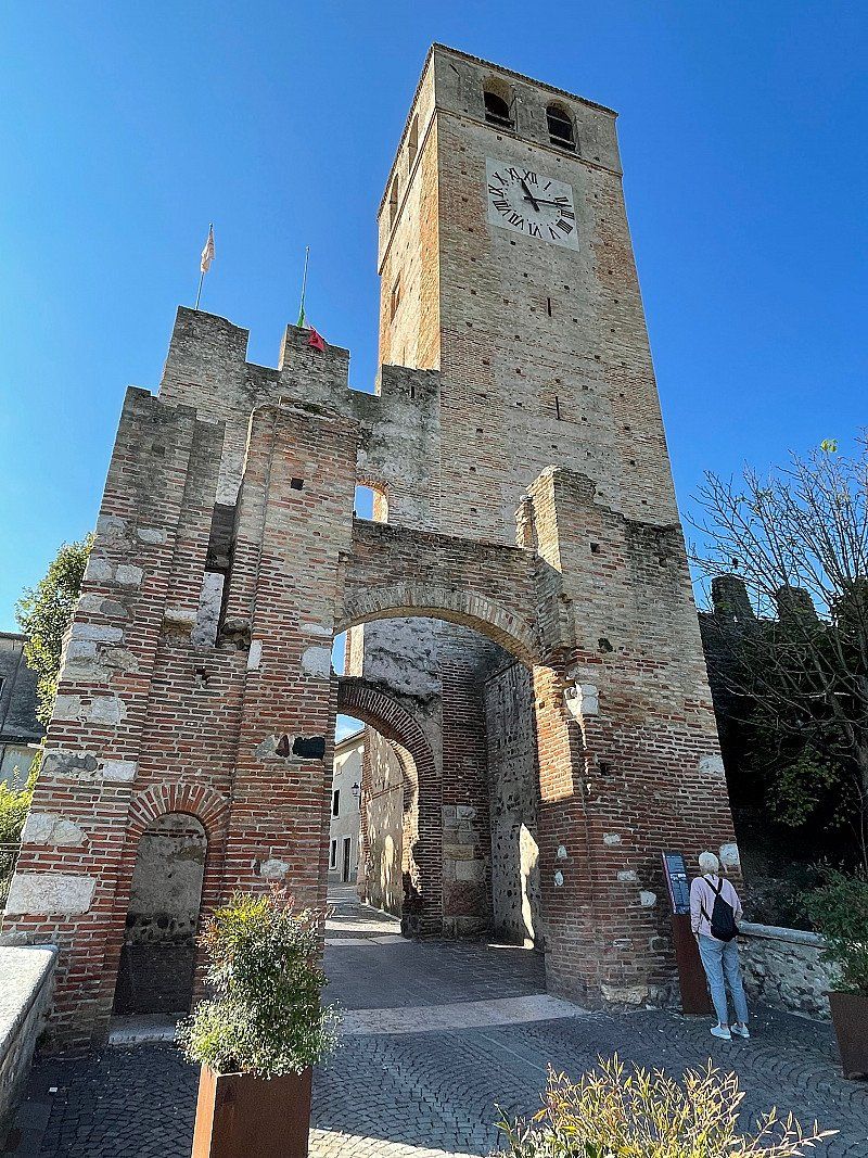
Borgo di Castellaro Lagusello
Bike excursion to Lagusello
Via Castello, 66, 46040 Castellaro Lagusello MN, Italien
45° 22' 18.7" N 10° 38' 5.5" E
45.3718656 10.6348515
• Head north on Via Castello Castellaro. Go for 99 m.
• Turn left onto Via Castello Castellaro. Go for 218 m.
• Continue on Piazza Generale Orlandi. Go for 11 m.
• Continue on Strada Castellaro Nuova Italia. Go for 249 m.
• Continue on Strada Nuova Italia. Go for 132 m.
• Turn left onto Strada Moscatello (SP18). Go for 2.9 km.
• Continue on Località Ponte del Cantone. Go for 403 m.
• Continue on Via Monzambano. Go for 231 m.
• Take the 1st exit from roundabout onto Strada Provinciale SS11-S. Martino-Pozzolengo (SP13DIR) toward MI-VE/A4/Brescia/Verona. Go for 1.4 km.
• Take the 1st exit from roundabout onto Località Sui Pozzi (SP106) toward Ponti S/M/Ponti S.Mincio. Go for 1.2 km.
• Continue on SP20. Go for 2.1 km.
• Take the 2nd exit from roundabout onto Via San Martino Solferino (SP20). Go for 362 m.
• Turn left onto Via Circonvallazione (SP19). Go for 1.6 km.
• Take the 2nd exit from roundabout. Go for 109 m.
• Continue on Via Mantova (SP28). Go for 422 m.
• Take the 1st exit from roundabout onto Via Tangenziale (SR11). Go for 1.5 km.
• Keep left onto Paradiso di Sotto toward Autostrada/A22/Affi/SR450/Verona/SR11. Go for 601 m.
• Continue on SS11dir. Go for 3.7 km.
• Continue on Strada Regionale di Affi (SR450). Go for 12.6 km.
• Take the 1st exit from roundabout toward SS12/A22. Go for 359 m.
• Take the 2nd exit from roundabout onto A22 (Autostrada del Brennero) toward Milano/A4/Brennero. Go for 191 km.
• Take the exit toward Vipiteno/Sterzing. Go for 1.4 km.
• Take the 4th exit from roundabout onto Passo di Giovo (SS44). Go for 417 m.
• Turn left onto Strada Statale di Val Sarentino e Passo Vizze (SS508). Go for 1.2 km.
• Turn left onto Zona Industriale. Go for 285 m.
• Arrive at Via Passo Pennes. Your destination is on the right.
☍
224,0 km
(2 hrs. 9 min.)
Day
Autobahn-Raststätte Vipiteno/Sterzing
After we tried unsuccessfully to get a place in Lazise on Lake Garda, we preferred to return home and stayed in Sterzing. The separated WoMo SP is ideal for staying overnight and separated from the truck spaces.
In Sterzing there is a public scale on which you can check the vehicle weight for a fee of 1 Euro (for 3.5 tons). The fee is graded according to weight class and is determined by the machine.
39049, Sterzing, Italy
46° 52' 50" N 11° 26' 20" E
46.8805556 11.4388889
• Head southwest on Via Passo Pennes. Go for 285 m.
• Turn right onto Strada Statale di Val Sarentino e Passo Vizze (SS508). Go for 1.2 km.
• Turn right onto Passo di Giovo (SS44). Go for 332 m.
• Take the 1st exit from roundabout onto A22 (Autostrada del Brennero) toward Autobahn/Autostrada/Brennero/Brenner. Go for 16.9 km.
• Continue on A13 (Brennerpass). Go for 31.7 km.
• Keep right onto A13 (Knoten Innsbruck-Berg Isel) toward Bregenz/Garmisch/Innsbruck-West. Go for 2.0 km.
• Continue on A12 (Inntal Autobahn). Go for 35.0 km.
• Take exit 113 toward Mötz/Reutte/Fernpass. Go for 333 m.
• Turn right onto Mötzer Landesstraße (L236). Go for 4.8 km.
• Take the 2nd exit from roundabout onto Mieminger Bundesstraße (B189) toward Reutte/Fernpaß/Nassereith. Go for 13.4 km.
• Keep left onto Mieminger Bundesstraße (B189) toward Reutte/Garmisch. Go for 91 m.
• Continue on Fernpass Bundesstraße (B179). Go for 49.2 km.
• Continue on Grenztunnel Füssen (A7). Go for 106 km.
• Take exit 123 toward Vöhringen/Weißenhorn/Bellenberg. Go for 273 m.
• Take the 3rd exit from roundabout onto NU14 toward Krumbach/Weißenhorn. Go for 3.3 km.
• Take the 1st exit from Goetheplatz roundabout onto St2019. Go for 659 m.
• Take the 3rd exit from roundabout onto Roggenburger Straße (St2019). Go for 4.9 km.
• Arrive at Weißenhorner Straße (St2019). Your destination is on the left.
☍
270,1 km
(2 hrs. 56 min.)
Day
Brauerei Biberach
Good SP to rest. There is a trusted drinks fridge. V / E available.
Weißenhorner Straße 24, 89297, Roggenburg-Biberach, Germany
48° 17' 16.4" N 10° 13' 13.3" E
48.2878755 10.2203567
• Head toward Rosenbergweg on Weißenhorner Straße (St2019). Go for 4.8 km.
• Take the 2nd exit from roundabout onto St2019. Go for 686 m.
• Take the 3rd exit from Goetheplatz roundabout onto Illerberger Straße (NU14). Go for 3.2 km.
• Take ramp onto A7 toward Ulm. Go for 20.1 km.
• Take exit 120 toward Stuttgart/Ulm onto A8. Go for 101 km.
• Continue on A8 toward Karlsruhe/Basel/Leonberg-West. Go for 53.8 km.
• Take the exit toward Frankfurt a.M./Mannheim/Karlsruhe/Landau (Pfalz) onto A5 (Autobahndreieck Karlsruhe). Go for 31.6 km.
• Take exit 41 toward Kronau/Östringen/Bad Schönborn/Waghäusel. Go for 346 m.
• Take the 3rd exit from roundabout onto L555 toward Karlsruhe/A5/Philippsburg/Waghäusel. Go for 636 m.
• Take the 2nd exit from roundabout onto L555 toward Philippsburg/Waghäusel. Go for 3.1 km.
• Take the 2nd exit from roundabout onto Kronauer Straße toward Kirrlach-Ortsmitte. Go for 958 m.
• Continue on Waghäusler Straße. Go for 621 m.
• Take the 1st exit from roundabout onto Bruchsaler Straße. Go for 19 m.
• Continue on Schwetzinger Straße. Go for 720 m.
• Turn right onto Friedrich-Schott-Straße. Go for 24 m.
• Turn right onto Friedrich-Schott-Straße. Go for 91 m.
• Arrive at Friedrich-Schott-Straße. Your destination is on the left.
☍
221,6 km
(2 hrs. 3 min.)
Day
Fa. Carsten Stäbler, Waghäusel, Deutschland
After we had determined the vehicle weight in Sterzig, we drove by the Stäbler company. We were made an offer for a charge.
Friedrich-Schott-Straße 2, 68753 Waghäusel, Deutschland
49° 14' 59.3" N 8° 32' 42" E
49.2497966 8.5450017
• Head southeast on Friedrich-Schott-Straße. Go for 111 m.
• Turn left onto Friedrich-Schott-Straße. Go for 94 m.
• Turn right onto Schwetzinger Straße. Go for 297 m.
• Take the 1st exit from roundabout onto K3587. Go for 1.8 km.
• Continue on K4255. Go for 2.1 km.
• Turn left onto L546 toward Speyer/Neulußheim/Hockenheim/Reilingen. Go for 478 m.
• Take the 2nd exit from roundabout onto L546 toward A6/Hockenheim/Neulußheim. Go for 2.1 km.
• Turn left and take ramp toward B36/Karlsruhe/Mannheim/Speyer/Hockenheim. Go for 157 m.
• Turn right onto L560 toward Mannheim/Speyer/Hockenheim. Go for 1.7 km.
• Continue on B39. Go for 6.2 km.
• Turn right and take ramp onto A6 toward Frankfurt. Go for 21.8 km.
• Continue on A67 toward Hannover/Frankfurt/Köln/Darmstadt. Go for 35.1 km.
• Continue on E451 (Darmstädter Kreuz) toward Hannover/Dortmund/Frankfurt/A5. Go for 877 m.
• Continue on A5. Go for 20.7 km.
• Take the exit toward Köln/Wiesbaden/Kelsterbach/Flughafen Frankfurt/München/Würzburg/Offenbach/F-Süd onto A3. Go for 9.0 km.
• Take exit 52 toward Bad Homburg/Frankfurt/Kassel onto A661. Go for 12.4 km.
• Take exit 8 toward Friedberg/Bad Vilbel onto B3. Go for 4.3 km.
• Take ramp onto Homburger Straße toward Bad Vilbel/Nieder-Eschbach/Nieder Erlenbach/Bad Vilbel-Massenheim. Go for 894 m.
• Pass 2 roundabouts and continue on Homburger Straße. Go for 239 m.
• Take the 2nd exit from roundabout onto Kasseler Straße. Go for 102 m.
• Turn right onto Homburger Straße. Go for 131 m.
• Turn left onto Homburger Straße. Go for 9 m.
• Turn right toward Parkstraße. Go for 160 m.
• Turn right onto Parkstraße. Go for 191 m.
• Arrive at Parkstraße. Your destination is on the left.
☍
121,0 km
(1 hrs. 10 min.)
Bad Vilbel, Deutschland
61118 Bad Vilbel, Deutschland
50° 10' 56.4" N 8° 44' 22.1" E
50.1823356 8.7394805