• Continue on A9 (Autostrada dei Laghi). Go for 31.0 km.
• Take the left exit onto A8 (Autostrada dei Laghi). Go for 5.1 km.
• Take the exit toward E64/Torino/A4/Genova/A7/Bologna/A1 onto A50 (Tangenziale Ovest). Go for 20.5 km.
• Take the exit toward Genova onto A7 (Autostrada Milano-Genova). Go for 81.0 km.
• Take the exit toward Serravalle S. Go for 584 m.
• Take the 3rd exit from roundabout onto Via Novi (SP35bis). Go for 813 m.
• Take the 3rd exit from roundabout onto Via Novi (SP35bis). Go for 357 m.
• Take the 2nd exit from roundabout onto Via della Moda. Go for 152 m.
• Turn right onto Via della Moda. Go for 145 m.
• Turn left toward Via della Moda. Go for 68 m.
• Continue on Via della Moda. Go for 59 m.
• Turn left. Go for 19 m.
• Arrive at your destination on the right.
☍
236,6 km
(2 hrs. 10 min.)
Serravalle Designer Outlet
Via della Moda 1, Serravalle Scrivia, Alessandria, Piemont, Italien
44° 44' 6.2" N 8° 50' 14.3" E
44.7350576 8.8372989
• Head toward Via della Moda. Go for 19 m.
• Turn left onto Via della Moda. Go for 61 m.
• Turn left toward Via della Moda. Go for 47 m.
• Continue on Via della Moda. Go for 106 m.
• Turn sharp left onto Via della Moda. Go for 88 m.
• Turn right onto Via della Moda. Go for 128 m.
• Take the 3rd exit from roundabout onto Via Novi (SP35bis) toward Milano/A7/Genova/Tortona/Serravalle S. Centro. Go for 402 m.
• Take the 2nd exit from roundabout onto Via Novi (SP35bis) toward Milano/A7/Genova/Serravalle S. Centro. Go for 812 m.
• Take the 2nd exit from roundabout onto A7 (Autostrada Milano-Genova) toward Genova. Go for 49.7 km.
• Take the exit toward Centro/Fiera di Genova onto SS1 (Strada Aldo Moro). Go for 3.5 km.
• Take ramp onto Via delle Casaccie toward Piazza De Ferrari/Corvetto. Go for 1.2 km.
• Continue on Via Ettore Vernazza. Go for 265 m.
• Continue on Piazza Raffaele De Ferrari. Go for 42 m.
• Turn right onto Piazza Raffaele De Ferrari. Go for 21 m.
• Continue on Via Francesco Petrarca. Go for 70 m.
• Turn right onto Via di Porta Soprana. Go for 59 m.
• Continue on Via di Porta Soprana. Go for 14 m.
• Arrive at Via di Porta Soprana.
☍
56,5 km
( 47 min.)
Genua
Genua, Ligurien, Italien
44° 24' 26.1" N 8° 56' 1.9" E
44.4072600 8.9338624
• Head northwest on Via di Porta Soprana.
• Arrive at Via di Porta Soprana.
☍
Distance not available
(Duration not available)
Never come back
Departure port: Genua
Genua, Ligurien, Italien
44.4072600 8.9338624
Arrival port: Posthudorra/Porto Torres
Sassari, Sardinien, Italien
40.83703338.4013292
• Head toward Via Amsicora on Corso Vittorio Emanuele II (SS131). Go for 55 m.
• Turn left onto Via Petronia. Go for 338 m.
• Turn right onto Via Principe di Piemonte. Go for 228 m.
• Take the 5th exit from roundabout onto Via Balai. Go for 833 m.
• Turn right onto Via Benedetto Croce. Go for 480 m.
• Continue on Via Tramontana. Go for 724 m.
• Take the 2nd exit from roundabout onto SP81. Go for 4.8 km.
• Pass 4 roundabouts and continue on SP81. Go for 5.8 km.
• Turn right. Go for 88 m.
• Turn right. Go for 164 m.
• Arrive at your destination on the left.
☍
Distance not available
(Duration not available)
Camping Villaggio LI NIBARI
Strada Provinciale 81 km 6, 07037, Marina di Sorso, Italien
40° 49' 27.2" N 8° 32' 40.4" E
40.8242100 8.5445600
• Head northwest. Go for 164 m.
• Turn left toward SP81. Go for 88 m.
• Turn left onto SP81. Go for 1.2 km.
• Pass 2 roundabouts and continue on SP81. Go for 1.9 km.
• Turn left toward Via Buddi Buddi. Go for 1.3 km.
• Continue on Via Buddi Buddi. Go for 546 m.
• Take the 1st exit from roundabout onto Via Grazia Deledda (SP25). Go for 2.8 km.
• Pass 2 roundabouts and continue on SS131. Go for 5.7 km.
• Take the 2nd exit from roundabout onto Via dell'Industria. Go for 2.4 km.
• Take ramp onto SS131 toward Sassari/Olbia/Nuoro/Oristano/Cagliari. Go for 2.1 km.
• Take ramp toward Stintino/Alghero/Aeroporto Alghero. Go for 313 m.
• Take the 1st exit from roundabout onto SS131 toward Stintino/Alghero. Go for 570 m.
• Take the 2nd exit from roundabout onto Strada Provinciale Porto Torres-Stintino-la Pelosa (SP34). Go for 1.3 km.
• Continue toward Strada Provinciale Porto Torres-Stintino-la Pelosa/SP34. Go for 45 m.
• Take the 3rd exit from roundabout onto Strada Provinciale Porto Torres-Stintino-la Pelosa (SP34). Go for 4.1 km.
• Turn left onto SP93. Go for 9.1 km.
• Turn right onto Via Fausto Coppi (SP18). Go for 8.1 km.
• Turn left onto Via Argentiera (SP18). Go for 5.0 km.
• Turn left onto Via Argentiera (SP18). Go for 13 m.
• Turn slightly left onto Via La Plata (SP18). Go for 192 m.
• Continue on Strada Vicinale Monte Fiocca Tronco A (SP18). Go for 83 m.
• Turn slightly right onto Piazza Camillo Marchese Argentiera (SP18). Go for 266 m.
• Continue on Via Fancello (SP18). Go for 154 m.
• Continue on Viale Umberto I (SP18). Go for 51 m.
• Continue on Via Bazzinita (SP18). Go for 113 m.
• Continue on Via Pozzo Podestà (SP18). Go for 302 m.
• Turn right onto Via Ettore Mura. Go for 101 m.
• Arrive at Via Ettore Mura. Your destination is on the right.
☍
48,0 km
( 52 min.)
Day
Day
Day
Argentiera, Sassari, Italien
40° 44' 1.9" N 8° 8' 53.9" E
40.7338696 8.1483093
• Head toward Via Pasquale Paoli on Via Ettore Mura. Go for 101 m.
• Turn left onto Piazza Cantina (SP18). Go for 302 m.
• Continue on Via Bazzinita (SP18). Go for 113 m.
• Continue on Viale Umberto I (SP18). Go for 51 m.
• Continue on Via Fancello (SP18). Go for 154 m.
• Continue on Piazza Camillo Marchese Argentiera (SP18). Go for 266 m.
• Turn slightly left onto Strada Vicinale Monte Fiocca Tronco A (SP18). Go for 83 m.
• Continue on Via La Plata (SP18). Go for 192 m.
• Turn slightly right onto Via Argentiera (SP18). Go for 13 m.
• Turn right onto Via Argentiera (SP18). Go for 4.9 km.
• Keep left onto Via Argentiera (SP18). Go for 116 m.
• Continue on Via Lampianu (SP57). Go for 1.6 km.
• Continue on SP57. Go for 1.7 km.
• Turn left onto Strada Vicinale La Muntagna. Go for 162 m.
• Arrive at Strada Vicinale La Muntagna. Your destination is on the left.
☍
9,8 km
( 18 min.)
Sassari
La Pedraia, Sassari, Sardinien, Italien
40° 46' 22" N 8° 11' 14.9" E
40.7727661 8.1874588
• Head east on Strada Vicinale La Muntagna. Go for 162 m.
• Turn right onto SP57. Go for 1.7 km.
• Turn left onto Strada Provinciale Scala Erre-Canaglia-Palmadula (SP4). Go for 153 m.
• Turn left onto Strada Provinciale Scala Erre-Canaglia-Palmadula (SP4). Go for 3.0 km.
• Turn left onto Strada Vicinale La Pimpinella. Go for 379 m.
• Arrive at Strada Vicinale La Pimpinella. Your destination is on the left.
☍
5,5 km
( 10 min.)
Sassari
SP4, Canaglia, Sassari, Sardinien, Italien
40° 46' 22.7" N 8° 13' 3.6" E
40.7729804 8.2176622
• Head toward Strada Provinciale Scala Erre-Canaglia-Palmadula on Strada Vicinale La Pimpinella. Go for 379 m.
• Turn right onto Strada Provinciale Scala Erre-Canaglia-Palmadula (SP4). Go for 3.0 km.
• Turn right onto Strada Provinciale Scala Erre-Canaglia-Palmadula (SP4). Go for 153 m.
• Turn sharp left onto Via Lampianu (SP57). Go for 1.6 km.
• Turn left onto Via Argentiera (SP18). Go for 1.7 km.
• Turn right onto SP69. Go for 10.4 km.
• Turn right. Go for 4.0 km.
• Turn left. Go for 2.3 km.
• Turn right. Go for 199 m.
• Turn right. Go for 30 m.
• Arrive at your destination on the left.
☍
23,8 km
( 37 min.)
Camping Village Glamping Torre del Porticciolo
Località Porticciolo, 07041, Alghero, Italien
40° 38' 33.8" N 8° 11' 24.7" E
40.6427276 8.1902057
• Head south. Go for 1.2 km.
• Turn right onto SP55bis. Go for 1.4 km.
• Turn right onto SP55. Go for 5.4 km.
• Continue on Località Capo Caccia (SP55). Go for 1.3 km.
• Keep right onto Località Capo Caccia (SP55). Go for 191 m.
• Turn slightly left onto Località Capo Caccia (SP55). Go for 1.5 km.
• Keep left onto Località Capo Caccia (SP55). Go for 189 m.
• Take the 1st exit from roundabout onto SP55. Go for 591 m.
• Arrive at SP55. Your destination is on the left.
☍
11,7 km
( 25 min.)
Day
Capo Caccia, Alghero, Sassari, Italien
Capo Caccia, 07041 Alghero, Sassari, Italien
40° 33' 39" N 8° 9' 50" E
40.5608330 8.1638890
• Head north on SP55. Go for 558 m.
• Take the 1st exit from roundabout onto Località Capo Caccia (SP55). Go for 205 m.
• Turn sharp left onto Località Capo Caccia. Go for 664 m.
• Arrive at Località Capo Caccia. Your destination is on the left.
☍
1,4 km
( 4 min.)
Neptungrotte, Alghero, Sassari, Italien
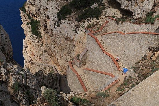
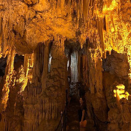
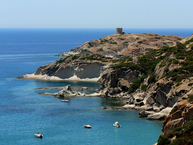
The cliffs of Capo Caccia hide a secret:
Admittedly, the impressive natural testimony is not that secret, almost popular or, to be more precise, one of the most beautiful sights in Sardinia.
In the steep rocky coast west of Alghero you will find the two million year old Neptune Grotto.
An imposing, gold-shining stalactite cave that has been carved into the rock material by freshwater streams over a total length of almost four kilometers.
You can only partially enter the cave, but you will be able to gather breathtaking impressions of massive stalagmites and tittes.
Grotte di Netturn You could also visit the popular travel destination with your children without any safety concerns.
The excursion tip is equally appreciated by locals and tourists and costs you around 12 € entry.
get there: From Alghero you drive about 45 minutes along the west coast of Sardinia to Capo Caccia. Directly from the parking lot of the coast, around 650 steps lead you down a well-fortified and wide staircase to the entrance of the grotto. The view of the sea rewards you for your effort. Alternatively, you can take a 40-minute boat ride from Alghero directly to the grotto. You can plan around €15 per person for this. our travel tip: Please take a jacket or sweater with you into the grotto to prevent circulatory problems. In the cave, the temperature is constantly around 10 °C.
07041 Alghero, Sassari, Italien
40° 33' 54.1" N 8° 9' 37.6" E
40.5650296 8.1604548
• Head southeast on Località Capo Caccia. Go for 3.7 km.
• Continue on SP55. Go for 5.5 km.
• Continue on Strada Vicinale Sant'Igori (SP55). Go for 489 m.
• Continue on SP55. Go for 3.2 km.
• Take the 2nd exit from roundabout onto Località Palmavera (SS127bis). Go for 2.3 km.
• Continue on SS127bis. Go for 3.0 km.
• Take the 2nd exit from roundabout onto SS127bis. Go for 957 m.
• Take the 1st exit from roundabout onto Viale 1 Maggio. Go for 1.2 km.
• Continue on Viale 1 Maggio. Go for 1.2 km.
• Continue on Via Lido. Go for 1.3 km.
• Take the 1st exit from roundabout onto Via Giuseppe Garibaldi. Go for 1.1 km.
• Turn right onto Via Sassari. Go for 379 m.
• Turn left onto Via 20 Settembre. Go for 247 m.
• Turn right onto Via Alberto La Marmora. Go for 28 m.
• Turn right onto Via Nuoro. Go for 15 m.
• Arrive at Via Nuoro. Your destination is on the left.
☍
24,7 km
( 47 min.)
Day
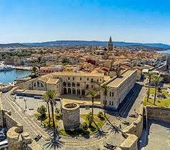
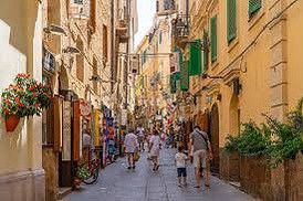
Alghero, Sassari, Italien
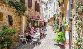
Alghero is one of the liveliest and most exciting towns in Sardinia. The former Catalan enclave enchants with a picturesque old town, an architectural mix of cultures and jewelery made from its world-famous corals. From the picturesque old town on a ledge to the traditional harbor and a long beach, its unique atmosphere unfolds. And that has a lot to do with the history of Sardinia's fifth largest city: Alghero was a Catalan enclave for over 400 years. The Sardinian inhabitants were replaced by Catalan - and so many mostly older residents of Alghero still speak the Catalan dialect Algherese.
In addition to the Sardinian, Italian and European flags, the Catalan flag also flies above the town hall. A dynamic juxtaposition of cultures that has also had a significant influence on the architecture: Catalan Gothic can be found in many of the city's buildings, such as the Church of San Francesco in the heart of the old town. So it's no wonder that the inhabitants of Alghero affectionately call their city Little Barcelona. Incidentally, people have lived here for centuries from lobster fishing. However, the north-west coast of Sardinia is world-famous for its corals. Numerous jewelers still process the colorful sea plants in Alghero into special jewelery today.
• Head toward Via Angelo Roth on Via Nuoro. Go for 107 m.
• Continue on Piazza della Mercede. Go for 86 m.
• Turn right onto Viale Giovanni XXIII (SS292). Go for 1.5 km.
• Take the 1st exit from roundabout onto Via Don Giovanni Minzoni (SS127bis). Go for 223 m.
• Take the 2nd exit from roundabout onto Via Don Giovanni Minzoni (SS127bis). Go for 260 m.
• Keep left toward Via Don Giovanni Minzoni/SS127bis. Go for 55 m.
• Take the 3rd exit from roundabout onto Via Don Giovanni Minzoni (SS127bis). Go for 1.1 km.
• Turn left onto Via Puglia. Go for 118 m.
• Turn left onto Via Liguria. Go for 432 m.
• Turn left onto Via Lido. Go for 40 m.
• Turn right. Go for 213 m.
• Turn left. Go for 42 m.
• Arrive at your destination on the left.
☍
4,2 km
( 10 min.)
Camping La Mariposa
Sassari, Sardinien, Italien
40° 34' 41.8" N 8° 18' 44.3" E
40.5782774 8.3122963
• Head west. Go for 255 m.
• Turn right onto Via Lido. Go for 1.3 km.
• Take the 1st exit from roundabout onto Via Giuseppe Garibaldi. Go for 1.1 km.
• Turn right onto Via Sassari. Go for 379 m.
• Turn right onto Via 20 Settembre. Go for 99 m.
• Continue on Piazza Sulis. Go for 40 m.
• Take the 2nd exit from roundabout onto Lungomare Dante. Go for 87 m.
• Keep right onto Lungomare Dante. Go for 66 m.
• Turn left onto Via Antonio Gramsci. Go for 382 m.
• Continue on Lungomare Dante. Go for 52 m.
• Keep right onto Lungomare Valencia. Go for 477 m.
• Continue on Viale della Resistenza. Go for 205 m.
• Turn right onto Strada Provinciale Alghero-Bosa (SP105). Go for 4.6 km.
• Continue on SP105. Go for 18.0 km.
• Continue on SP49. Go for 12.9 km.
• Arrive at SP49.
☍
39,9 km
( 48 min.)
Torre Argentina, Bosa, Oristano, Italien
Bosa, 08013 Bosa OR, Italien
40° 19' 9.9" N 8° 26' 38" E
40.3194082 8.4438910
• Head east on SP49. Go for 6.4 km.
• Take the 2nd exit from roundabout onto SP49. Go for 532 m.
• Take the 2nd exit from roundabout onto Via Cristoforo Colombo (SS129bis). Go for 517 m.
• Continue on Via Nazionale (SS129bis). Go for 1.2 km.
• Turn left onto Via Roma (SP19). Go for 80 m.
• Continue on Ponte Vecchio (SP19). Go for 109 m.
• Continue on Piazza Duomo (SP19). Go for 40 m.
• Arrive at Piazza Duomo (SP19). Your destination is on the left.
☍
8,9 km
( 10 min.)
Day
Bosa, Oristano, Sardinien, Italien
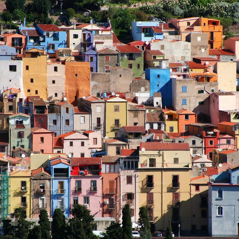
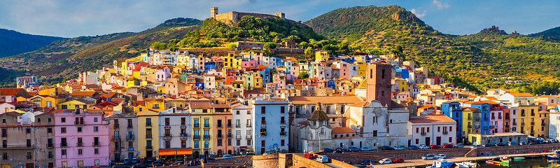
On the northwest coast of Sardinia, a trip to the small town of Bosa is worthwhile.
Even from afar you can see the colorful pastel colors of the charming baroque and classicist houses.
Bosa was an ideal place for the fur and leather industry due to its location directly on the river and its proximity to the sea.
Wine is still grown today on the fertile hills around the village, which you can enjoy in one of the numerous small cafés in the city center.
If you would like to take a closer look at the area, we recommend a hike to the castle complex in the old town.
Bosa Castello Malaspina From the Castello Malaspina you have a good overview of the city and the river Temo, which ends in the sea in the Bosa Marina. The sandy beach is known for its calm sea and is therefore one of the best places in Sardinia for a beach holiday with children.
We have also created an overview of the most beautiful beaches in Sardinia for you.
Getting there: Drive about 45 minutes south by car and reach Bosa on the west coast of Sardinia. A bus will take you to the small town in an hour. our travel tip: In the evening hours, stroll along the banks of the Termo past a palm-lined promenade and tranquil fishing boats.
08013 Bosa, Oristano, Italien
40° 17' 42.8" N 8° 30' 13.2" E
40.2952312 8.5036658
• Head toward Corso Vittorio Emanuele II on Piazza Duomo (SP19). Go for 7 m.
• Turn left onto Corso Vittorio Emanuele II (SP49). Go for 129 m.
• Turn left onto Via Palestro. Go for 72 m.
• Turn left onto Lungo Temo Alcide De Gasperi. Go for 144 m.
• Turn right onto Ponte Vecchio (SP19). Go for 109 m.
• Continue on Via Roma (SP19). Go for 257 m.
• Continue on Via dei Sarti (SS129bis). Go for 260 m.
• Continue on Via Barisone Seconda (SS129bis). Go for 327 m.
• Continue on SS129bis. Go for 1.5 km.
• Turn right onto SP35. Go for 3.0 km.
• Turn right onto Via Sant'Andrea. Go for 54 m.
• Turn left toward Via Roma. Go for 32 m.
• Turn right onto Via Roma. Go for 96 m.
• Turn slightly left onto Via Roma. Go for 158 m.
• Turn right onto SP35. Go for 1.9 km.
• Turn left onto Via Vittorio Emanuele III (SP35). Go for 573 m.
• Continue on Viale Vittorio Emanuele (SS292). Go for 7.2 km.
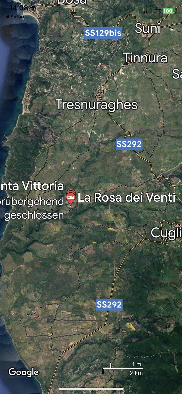
• Turn right onto Via Santa Vittoria. Go for 62 m.
• Take the 1st exit from roundabout onto Via Roma. Go for 64 m.
• Continue on Via Santa Vittoria. Go for 416 m.
• Turn right toward Regione Santa Vittoria. Go for 3.9 km.
• Turn right onto Regione Santa Vittoria. Go for 720 m.
• Arrive at Regione Santa Vittoria. Your destination is on the right.
Beautiful parking space with a magnificent view. Don't rely on the restaurant being open. 15€ including fresh water and gray water drain as well as electricity
Loc.colle di S.Vittoria, 09078 Sennariolo OR, Italien
40° 12' 4" N 8° 30' 11" E
40.2011111 8.5030556
• Head northeast on Regione Santa Vittoria. Go for 720 m.
• Turn left toward Via Santa Vittoria. Go for 3.9 km.
• Turn left onto Via Santa Vittoria. Go for 416 m.
• Continue on Via Roma. Go for 50 m.
• Take the 2nd exit from roundabout onto Via Santa Vittoria. Go for 89 m.
• Turn right onto Via 24 Maggio (SS292). Go for 4.1 km.
• Take the 1st exit from roundabout. Go for 2.2 km.
• Take the 1st exit from roundabout onto Strada Statale Nord Occidentale Sarda (SS292). Go for 8.8 km.
• Arrive at Strada Statale Nord Occidentale Sarda (SS292).
☍
20,2 km
( 26 min.)
Santa Caterina di Pittinuri
Strada Statale 292 Nord Occidentale Sarda, Santa Caterina di Pittinuri, Cùllieri/Cuglieri, Aristanis/Oristano, Sardinien, 09073, Italien
40° 7' 58.6" N 8° 30' 27.8" E
40.1329357 8.5077157
• Head southwest on Strada Statale Nord Occidentale Sarda (SS292). Go for 17.7 km.
• Take the 1st exit from roundabout onto SP66. Go for 7.4 km.
• Turn left toward SP7. Go for 93 m.
• Continue on SP7. Go for 6.3 km.
• Turn right onto SP59. Go for 5.6 km.
• Turn right. Go for 1.1 km.
• Turn left. Go for 213 m.
• Arrive at your destination on the right.
☍
38,4 km
( 37 min.)
Day
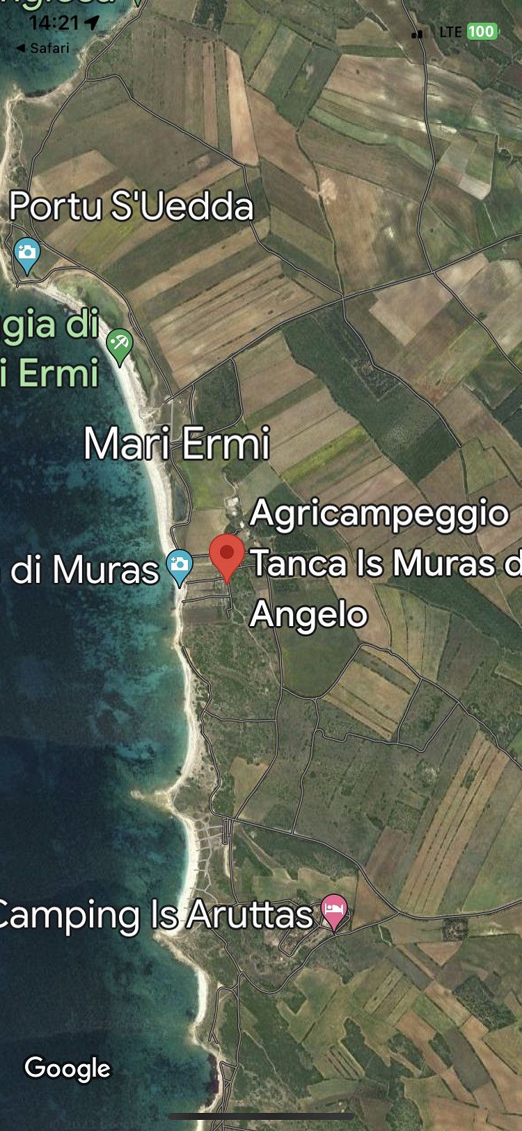
Agricampeggio Tanca Is Muras da Angelo, Mari Ermi, Oristano, Italien
Loc, 09170, 09072 Mari Ermi OR, Italien
39° 57' 43" N 8° 24' 11.7" E
39.9619506 8.4032363
• Head north. Go for 1.3 km.
• Turn right onto SP59. Go for 12 m.
• Turn left. Go for 759 m.
• Turn slightly right. Go for 991 m.
• Turn slightly right. Go for 346 m.
• Arrive at your destination on the left.
☍
3,4 km
( 9 min.)
Is Arutas, Cabras, Oristano, Italien
Is Arutas, 09072 Cabras OR, Italien
39° 56' 10.5" N 8° 24' 8.5" E
39.9362470 8.4023489
• Head south. Go for 2.1 km.
• Turn left toward SP6. Go for 3.7 km.
• Turn right onto SP6. Go for 2.3 km.
• Continue on Via Case Sparse (SP6). Go for 190 m.
• Turn slightly right onto SP6. Go for 701 m.
• Arrive at SP6. Your destination is on the left.
☍
8,9 km
( 21 min.)
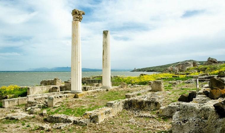
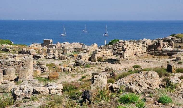
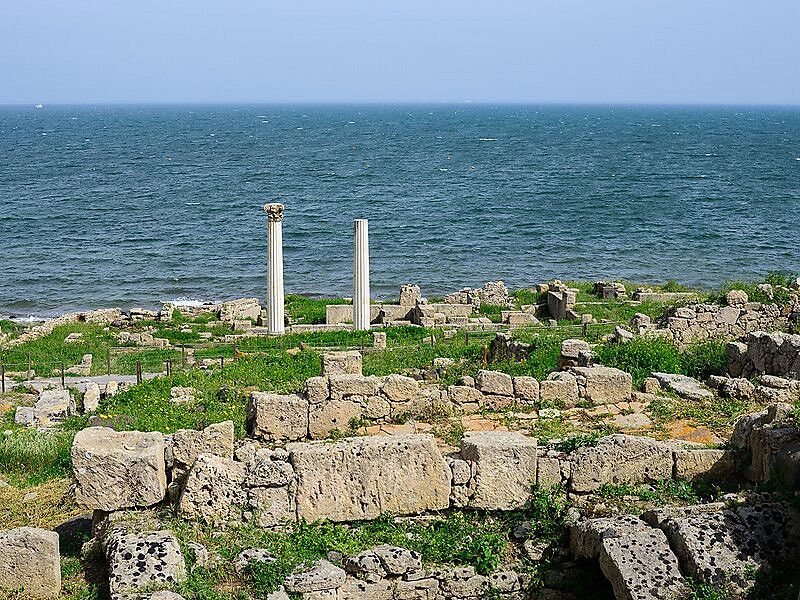
Area archeologica di Tharros, SP6, Cabras, Oristano, Italien
SP6, 09072 Cabras OR, Italien
39° 52' 26.5" N 8° 26' 24.4" E
39.8740376 8.4401219
• Head toward Via Case Sparse on SP6. Go for 701 m.
• Continue toward SP6. Go for 469 m.
• Turn slightly right onto SP6. Go for 10.3 km.
• Continue toward Via Tharros/SP1. Go for 68 m.
• Take the 1st exit from roundabout onto Via Tharros (SP1). Go for 739 m.
• Continue on Via Cristoforo Colombo (SP1). Go for 640 m.
• Take the 3rd exit from Piazza della Torre roundabout onto Via Stella Maris (SP1). Go for 356 m.
• Arrive at Via Stella Maris (SP1). Your destination is on the left.
☍
13,3 km
( 16 min.)
Wohnmobil Stellplatz, Oristano, Italien
09170 Oristano, Italien
39° 54' 28.4" N 8° 31' 12.6" E
39.9078920 8.5201771
• Head toward Via della Pineta on Via Stella Maris (SP1). Go for 2.0 km.
• Take the 2nd exit from roundabout onto Strada Provinciale Oristano Torre Grande (SP1). Go for 3.5 km.
• Take the 1st exit from roundabout onto SP54. Go for 1.4 km.
• Pass 5 roundabouts and continue on SP56. Go for 5.1 km.
• Turn right onto Via Giovanni XXIII (SP56). Go for 103 m.
• Take the 2nd exit from roundabout onto Via Giovanni XXIII (SP56). Go for 647 m.
• Turn right onto SP49. Go for 11.5 km.
• Continue on Corso Roma (SP49). Go for 369 m.
• Turn right onto Corso Italia. Go for 180 m.
• Arrive at Corso Italia. Your destination is on the left.
☍
24,9 km
( 24 min.)
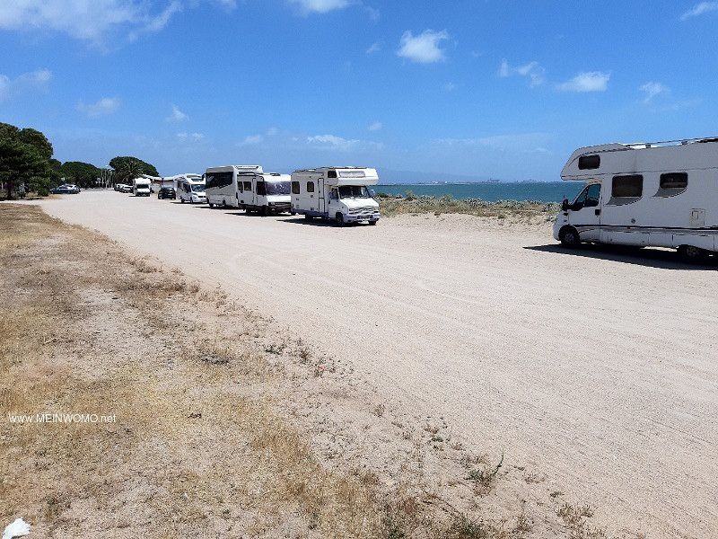
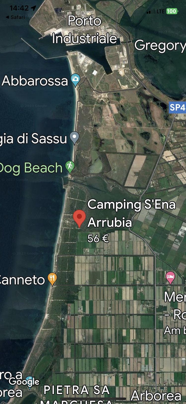
Camping S`Ena Arrubia
Str. A Mare 29, 09092, Arborea, Italien
39° 46' 24.2" N 8° 34' 48.7" E
39.7734000 8.5801900
• Head toward Via Santa Chiara on Corso Italia. Go for 180 m.
• Turn right onto Corso Roma (SP49). Go for 549 m.
• Continue on SP49. Go for 1.2 km.
• Take the 2nd exit from roundabout onto SP49. Go for 841 m.
• Take the 3rd exit from roundabout. Go for 107 m.
• Continue on SP49. Go for 2.4 km.
• Continue on Via Val d'Aosta (SP22/SP49). Go for 393 m.
• Continue on SP22/SP49. Go for 1.4 km.
• Turn left onto Strada di Bonifica. Go for 1.3 km.
• Turn right toward Strada Statale Sud Occidentale Sarda/SS126. Go for 13 m.
• Turn right onto Strada Statale Sud Occidentale Sarda (SS126). Go for 158 m.
• Turn left onto Strada Provinciale 92. Go for 932 m.
• Take the 3rd exit from roundabout onto Strada Provinciale di Terralba (SP61). Go for 3.4 km.
• Take ramp onto Strada Statale Carlo Felice (SS131) toward Cagliari. Go for 14.9 km.
• Take ramp onto SP53 toward Ales/Collinas. Go for 6.6 km.
• Take the 1st exit from roundabout. Go for 381 m.
• Turn right onto Strada Provinciale dell'Ipis (SP46). Go for 1.2 km.
• Continue on SP69. Go for 997 m.
• Turn left onto Strada Comunale Mogoro Lunamatrona. Go for 4.0 km.
• Continue on Strada Vicinale Lunamatrona Mogoro. Go for 1.4 km.
• Continue toward Via Oristano. Go for 28 m.
• Take the 3rd exit from roundabout onto Via Olbia. Go for 408 m.
• Continue on Via Carbonia. Go for 514 m.
• Turn left onto SP49. Go for 1.6 km.
• Continue toward SP49. Go for 31 m.
• Turn slightly left onto Strada Comunale Pauli Arbarei Tuili. Go for 3.1 km.
• Continue on Strada Comunale Tuili Pauli Arbarei (SP49). Go for 3.9 km.
• Take the 1st exit from roundabout onto Strada Provinciale del Nuraghe (SP44). Go for 626 m.
• Take the 2nd exit from roundabout onto Strada Provinciale del Nuraghe (SP44). Go for 1.9 km.
• Continue on SP44. Go for 572 m.
• Arrive at SP44. Your destination is on the right.
☍
54,9 km
( 41 min.)
Day
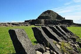
Nuraghe Su Nuraxi, Viale Su Nuraxi, Barumini, South Sardinia, Italien
You might think it's a debris field on top of a hill:
In fact, the building remains that you can discover in the southwest of Sicily are the remains of a so-called nuraghe.
The towers and walls at the foot of the Parco della Giara near Barumini are still clearly visible today.
Su NuraxiIt is amazing because archaeologists put the time of origin in the late Bronze Age between 1330 and 1250 BC. suspect. The complex, on which you can discover, among other things, a 14 m high tower, was only uncovered again in the 1950s and gradually made accessible to the public.
The interior of the fortress bears witness to the impressive craftsmanship that people demonstrated more than 3,000 years ago.
Getting there: Su Nuraxi is the best destination for a day trip. From Cagliari you can reach Barumini in the north in 55 minutes by car or 1.5 hours by bus. our travel tip: In order to really understand the importance of this prehistoric sight, it is actually worth taking a guided tour with commentary. With the entrance ticket, which costs around €12, you can also visit the museums in the area.
Viale Su Nuraxi, 09021 Barumini SU, Italien
39° 42' 22" N 8° 59' 28.1" E
39.7061112 8.9911390
• Head southeast on SP44. Go for 604 m.
• Continue on Viale Umberto I (SP44). Go for 83 m.
• Turn left onto Via Stazione. Go for 285 m.
• Turn slightly left onto Via Roma (SS197). Go for 4.9 km.
• Turn left onto Via Fra' Nicola. Go for 6 m.
• Turn right onto Via Giara. Go for 762 m.
• Continue on Strada Comunale della Giara. Go for 3.5 km.
• Turn left. Go for 2.1 km.
• Arrive at your destination.
☍
12,3 km
( 22 min.)
Giara di Gesturi,Sardinia, Italien
Giara di Gesturi, South Sardinia, Italien
39° 44' 46.7" N 8° 58' 47.1" E
39.7463111 8.9797467
• Head north. Go for 10.2 km.
• Turn slightly left toward SP16. Go for 371 m.
• Turn left onto SP16. Go for 3.1 km.
• Continue on SP41. Go for 2.0 km.
• Turn left onto Strada Statale di Laconi e di Uras (SS442). Go for 16.6 km.
• Turn left onto Via 4 Novembre (SP46). Go for 3.5 km.
• Take the 1st exit from roundabout onto Via Oristano (SP72). Go for 667 m.
• Continue on SP72. Go for 1.8 km.
• Continue on Strada Comunale Curcuris Pompu (SP72). Go for 1.6 km.
• Continue on Strada di Circonvallazione (SP72). Go for 2.7 km.
• Continue on SP99. Go for 1.0 km.
• Continue straight ahead. Go for 3.7 km.
• Take the 2nd exit from roundabout. Go for 894 m.
• Continue on Strada Provinciale di Mogoro (SP44). Go for 7.1 km.
• Continue on SP98. Go for 160 m.
• Continue on Strada Comunale Pabillonis Zeppera. Go for 938 m.
• Turn right onto Strada Provinciale di Santa Maria (SP64). Go for 2.2 km.
• Continue on SP64. Go for 602 m.
• Continue on SP64. Go for 3.7 km.
• Turn right onto SP65. Go for 16.0 km.
• Continue on Strada Vicolo Sant'Antonio (SP65). Go for 261 m.
• Continue on Via Mar Mediterraneo (SP65). Go for 264 m.
• Continue on SP65. Go for 14.8 km.
• Turn left onto SP65. Go for 605 m.
• Turn right toward Gutturu e Flumini. Go for 2.7 km.
• Continue on Gutturu e Flumini. Go for 944 m.
• Continue on Portu Maga. Go for 2.6 km.
• Arrive at your destination on the right.
☍
100,9 km
(1 hrs. 50 min.)
Day
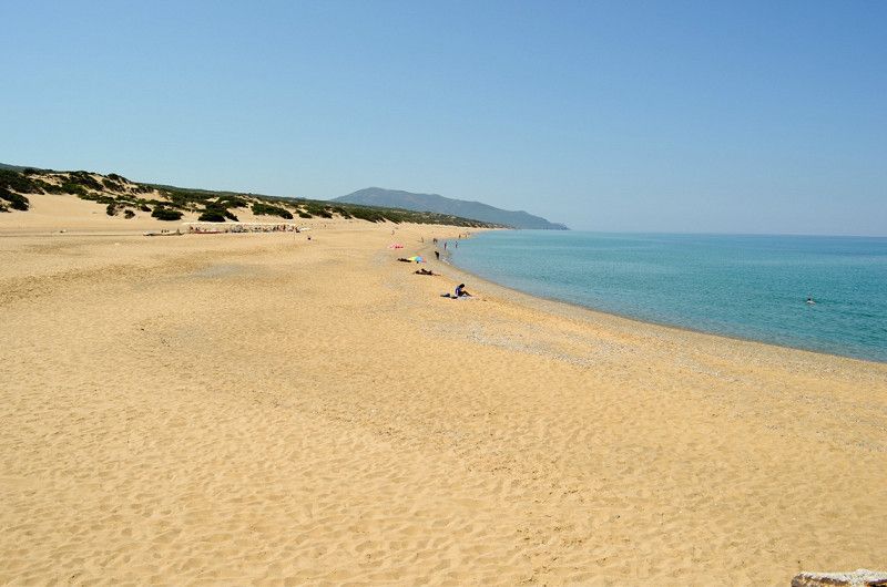
Costa Verde, South Sardinia, Italien
It may sound unbelievable:
But the southwest coast of Sardinia is still one of the most undeveloped regions of the whole island.
The Costa Verde is almost 47 kilometers long, lushly overgrown and almost deserted. Admittedly, the rugged coastal area is known and loved by locals and holidaymakers, but you won't find lively offshoots of mass tourism and classic party tourists here.
But we must also admit:
Even the busier beaches of Sardinia are comparatively quiet, which is why some of them even rank among the most beautiful beaches in Italy.
Beaches SardiniaAlthough the Costa Verde is a seemingly endless string of pristine beaches, you should be very careful when venturing into the sea. In some places the coast drops very sharply, so that you are immediately in deep water.
But you can also find one of the countless golden beaches just as quickly, which are framed by sand dunes up to 40 m high.
In the southern part of the Costa Verde there is a nature reserve that has turned out to be an ideal habitat for sea turtles.
Sometimes you can also see dolphins from the coast.
get there: A direct flight from Germany to Cagliari is best. Then you drive 1.5 hours by car or train through the interior to the Costa Verde. our travel tip: if you want it quiet, pitch your tents in one of the small hotels in the tranquil resort of Marina di Arbus. A good starting point for your journey of discovery on the Costa Verde is the Spiaggia di Piscinas beach section.
Costa Verde, SU, Italien
39° 34' 34.7" N 8° 27' 59.1" E
39.5762984 8.4664135
• Head northeast. Go for 162 m.
• Continue on Portu Maga. Go for 2.5 km.
• Continue on Gutturu e Flumini. Go for 944 m.
• Continue toward SP65. Go for 2.7 km.
• Turn right onto SP65. Go for 14.0 km.
• Continue on Sàtanca (SP65). Go for 418 m.
• Continue on SP65. Go for 434 m.
• Turn right onto SP66. Go for 304 m.
• Continue on SP68. Go for 5.1 km.
• Continue on Via Montevecchio (SP68). Go for 586 m.
• Turn left onto Via Repubblica (SS126). Go for 83 m.
• Turn right onto Viale Antonio Gramsci. Go for 309 m.
• Turn right onto Via Fratellanza Operaia. Go for 834 m.
• Turn right onto Via Dante Alighieri (SP67). Go for 419 m.
• Continue on Via Libertà (SP67). Go for 430 m.
• Continue on Via Is Strigas (SS126). Go for 18.3 km.
• Turn right onto SP83. Go for 11.2 km.
• Continue on Via Malfidano (SP83). Go for 1.2 km.
• Continue on Via Roma (SP83). Go for 254 m.
• Continue on SP83. Go for 5.7 km.
• Turn right toward Località Cala Domestica. Go for 38 m.
• Continue on Località Cala Domestica. Go for 1.3 km.
• Arrive at Località Cala Domestica. Your destination is on the left.
☍
66,9 km
(1 hrs. 24 min.)
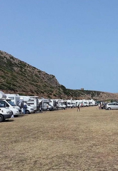
Parcheggio Cala Domestica, Buggerru, South Sardinia, Italien
When it comes to beautiful motorhome pitches in Sardinia by the sea, this one should definitely not be missing. Although it is only a large parking lot, you are absolutely quiet here and can reach several beaches on foot. The use of the very well-kept sanitary facilities costs 1 euro. Our tip: You can reach a tower in twenty minutes via a path. From there you have a fantastic view over the bay. You can get snacks at the beach bar nearby, but unfortunately you have to do without amenities such as electricity. But we promise you: The location right by the sea makes up for everything!
Info: 10 euros/night, toilet and shower, beach bar nearby
Località Cala Domestica, 09010, 09010 Buggerru SU, Italien
39° 22' 20.6" N 8° 22' 55.9" E
39.3723829 8.3821885
• Head southeast on Località Cala Domestica. Go for 1.3 km.
• Turn right onto SP83. Go for 1.3 km.
• Continue on Regione Canal Grande (SP83). Go for 852 m.
• Continue on SP83. Go for 5.5 km.
• Continue on Regione Monte Cani (SP83). Go for 1.3 km.
• Continue on SP83. Go for 1.8 km.
• Continue on Corso Pan di Zucchero (SP83). Go for 1.7 km.
• Continue on SP83. Go for 6.3 km.
• Continue on Stazione Monteponi (SP83). Go for 116 m.
• Turn right and take ramp. Go for 38 m.
• Turn right onto SS126. Go for 4.9 km.
• Keep left onto SS130. Go for 5.3 km.
• Take ramp. Go for 150 m.
• Take the 2nd exit from roundabout onto SP86. Go for 296 m.
• Continue on Regione Sa Stoia (SP86). Go for 946 m.
• Continue on SP86. Go for 4.0 km.
• Continue on Strada Provinciale per Iglesias (SP86). Go for 1.5 km.
• Turn right onto Strada Provinciale Villamassargia. Go for 27 m.
• Take the 3rd exit from roundabout onto Via Carbonia (SP2). Go for 437 m.
• Continue on Strada Senza Nome 16 (SP2). Go for 1.7 km.
• Continue on SP2. Go for 95 m.
• Continue on Località Santa Barbara (SP2). Go for 982 m.
• Continue on SP2. Go for 653 m.
• Continue on Regione Paucinu (SP2). Go for 3.5 km.
• Continue on SP2. Go for 8.0 km.
• Take the 1st exit from roundabout onto SS293. Go for 1.1 km.
• Turn left. Go for 208 m.
• Arrive at your destination on the right.
☍
54,2 km
( 48 min.)
Day
Castello di Acquafredda, Strada Statale 293 di Giba, Siliqua, Metropolitanstadt Cagliari, Italien
The story of Acquafredda The Acquafredda castle complex is a fortified structure that stands on a hill of volcanic origin, the Domo andesitico, a natural monument protected by the region. It was built in the 13th century by Ugolino Della Gherardesca, Count of Donoratico, ruler of the south-western part of Sardinia from 1257, after the fall of the Giudicato of Cagliari.
The Pisan nobleman who founded the Castle of Siliqua is also known as the "Cursed Count" because of the sad end he and his family met. After falling from grace, he was imprisoned in Pisa in the 'Gualandi Tower', also known as the 'Tower of Hunger', where he starved to death along with his sons and grandsons in 1288.
Strada Statale 293 di Giba, Km35, 09010 Siliqua CA, Italien
39° 15' 49.4" N 8° 49' 1.8" E
39.2637204 8.8171591
• Head southwest. Go for 208 m.
• Turn left onto SS293. Go for 24.5 km.
• Take the 3rd exit from roundabout onto SP79. Go for 1.5 km.
• Continue on Via Cagliari (SP79). Go for 934 m.
• Continue on Via Roma (SP79). Go for 240 m.
• Take the 1st exit from roundabout onto Circonvallazione Emilio Lussu. Go for 176 m.
• Turn left onto Via Giuseppe Mazzini. Go for 132 m.
• Turn right onto Via Fontane (SP79). Go for 496 m.
• Continue on Via Rio Mannu (SP70). Go for 6 m.
• Continue on Via Rio Manno (SP70). Go for 382 m.
• Turn left onto Via Argiolas (SP70). Go for 166 m.
• Continue on Via Teulada (SP70). Go for 255 m.
• Continue on Barrua Susu (SP70). Go for 1.3 km.
• Continue on Frazione Barrua (SP70). Go for 1.1 km.
• Continue on SP70. Go for 2.1 km.
• Continue on Frazione Su Benatzu (SP70). Go for 371 m.
• Continue on SP70. Go for 376 m.
• Turn left onto Località Zuddas. Go for 75 m.
• Turn right onto Località Zuddas. Go for 14 m.
• Arrive at Località Zuddas. Your destination is on the right.
☍
34,3 km
( 33 min.)
Grotte Is Zuddas, località Is Zuddas, Santadi, South Sardinia, Italien
località Is Zuddas, 09010 Santadi SU, Italien
39° 2' 45.9" N 8° 42' 18.7" E
39.0460864 8.7051959
• Head northwest on Località Zuddas. Go for 14 m.
• Turn left onto Località Zuddas. Go for 75 m.
• Turn left onto SP70. Go for 2.8 km.
• Continue on Frazione Is Carillus (SP70). Go for 384 m.
• Continue on SP70. Go for 9.6 km.
• Turn right onto SS195. Go for 12.9 km.
• Turn left onto Via Porto Pino (SP73). Go for 759 m.
• Take the 3rd exit from roundabout onto Via Porto Pino (SP73). Go for 495 m.
• Continue on Via Is Cinus (SP73). Go for 940 m.
• Continue on Via Is Cinus (SP73). Go for 832 m.
• Continue on Via Is Pillonis (SP73). Go for 1.4 km.
• Continue on SP110. Go for 1.1 km.
• Continue on Via del Mare (SP110). Go for 504 m.
• Turn left onto Via del Porticciolo. Go for 241 m.
• Arrive at Via del Porticciolo. Your destination is on the right.
☍
32,0 km
( 33 min.)
Day
Porto Pino, South Sardinia, Italien
09010 Porto Pino SU, Italien
38° 57' 49" N 8° 35' 43.6" E
38.9636015 8.5954553
• Head toward Via Porto Pineddu on Via del Porticciolo. Go for 92 m.
• Turn right onto Via dei Pescatori. Go for 172 m.
• Turn right onto Via del Mare (SP110). Go for 763 m.
• Continue on SP110. Go for 1.1 km.
• Continue on Via Is Pillonis (SP110). Go for 620 m.
• Keep right onto Via Is Pillonis (SP110). Go for 753 m.
• Continue on Via Is Cinus (SP73). Go for 1.8 km.
• Continue on Via Porto Pino (SP73). Go for 434 m.
• Take the 2nd exit from roundabout onto Via Porto Pino (SP73). Go for 788 m.
• Turn right onto Via Italia (SS195). Go for 10.4 km.
• Turn right onto SP71. Go for 4.4 km.
• Keep right toward SP71. Go for 523 m.
• Turn right onto SP71. Go for 5.6 km.
• Continue on Località Piscinnì (SP71). Go for 254 m.
• Continue on SP71. Go for 454 m.
• Turn sharp left toward SP71. Go for 2.7 km.
• Turn left onto SP71. Go for 542 m.
• Turn slightly right onto SP71. Go for 1.3 km.
• Turn right. Go for 607 m.
• Arrive at your destination.
☍
33,2 km
( 53 min.)
Strand von Tuerredda, Località Tuerredda, Teulada, Metropolitanstadt Cagliari, Italien
Località Tuerredda, 09019 Teulada CA, Italien
38° 53' 40.6" N 8° 48' 47.3" E
38.8946095 8.8131483
• Head north. Go for 607 m.
• Turn right onto SP71. Go for 391 m.
• Continue on SP71. Go for 3.6 km.
• Continue on Viale Chia (SP71). Go for 2.8 km.
• Take the 2nd exit from roundabout onto Viale Chia (SP71). Go for 986 m.
• Continue on SP71. Go for 1.4 km.
• Turn slightly right toward SP71. Go for 61 m.
• Turn right onto SS195. Go for 8.0 km.
• Take the 2nd exit from roundabout onto SS195 toward Cagliari. Go for 1.5 km.
• Take the 1st exit from roundabout onto Via Flumendosa. Go for 1.8 km.
• Arrive at Via Flumendosa.
☍
21,2 km
( 30 min.)
Day
Via Flumendosa, 14, Santa Margherita, Metropolitanstadt Cagliari, Italien
If you enter Via Flumindosa 14 into your navigation system, you will find camper van sites right by the sea at your destination. Strictly speaking it is just a parking lot, but the location is breathtakingly beautiful. In addition, the beach is directly connected to the parking lot and you can be there in a few minutes on foot. There is an excellent parking zone for campers. The sanitary facilities are a bit old, but there are showers with hot water - not always a matter of course. Especially in the low season it is pleasantly quiet here.
Info: free, toilets and showers
Via Flumendosa, 14, 09010 Santa Margherita CA, Italien
38° 57' 35.2" N 8° 58' 21.3" E
38.9597867 8.9725915
• Head west on Via Flumendosa. Go for 1.0 km.
• Turn right toward Località Santa Margherita di Pula. Go for 311 m.
• Continue on Località Santa Margherita di Pula. Go for 41 m.
• Turn right onto Via Tirso. Go for 492 m.
• Turn left onto Via Tevere. Go for 364 m.
• Take the 1st exit from roundabout onto SS195 toward Cagliari. Go for 1.5 km.
• Pass 4 roundabouts and continue on SS195. Go for 5.7 km.
• Take the 3rd exit from roundabout. Go for 976 m.
• Turn right. Go for 69 m.
• Turn right. Go for 3.5 km.
• Keep left. Go for 2.5 km.
• Take ramp. Go for 597 m.
• Continue straight ahead. Go for 2.1 km.
• Turn right. Go for 1.0 km.
• Turn left. Go for 9.5 km.
• Arrive at your destination.
☍
29,7 km
( 51 min.)
Sarrocu/Sarroch
Strada_vecchia_cemento, Medau di Monte Nieddu, Sarrocu/Sarroch, Cagliari, Sardinien, 09018, Italien
39° 5' 49" N 8° 54' 18.4" E
39.0969541 8.9051130
• Head southwest. Go for 10.5 km.
• Turn left. Go for 1.2 km.
• Continue straight ahead. Go for 864 m.
• Continue straight ahead. Go for 426 m.
• Take left ramp. Go for 2.2 km.
• Continue on Sa Nuraxedda. Go for 2.6 km.
• Keep left. Go for 5.4 km.
• Take ramp. Go for 272 m.
• Take the 3rd exit from roundabout onto SP91. Go for 1.5 km.
• Take the 2nd exit from roundabout onto Strada Statale Sulcitana (SS195). Go for 507 m.
• Pass 2 roundabouts and continue on Strada Statale Sulcitana (SS195). Go for 12.7 km.
• Take ramp onto Via Ponte Nuovo. Go for 2.1 km.
• Continue on SS195racc. Go for 2.6 km.
• Take ramp onto Strada Statale Cagliaritana (SS554) toward Villasimius/Oristano/Sassari/Quartu S. E./Muravera/SS125/Cagliari Pirri. Go for 6.4 km.
• Turn left onto Strada Statale Cagliari Dolianova (SS387). Go for 10.3 km.
• Turn right toward Via Cagliari/SS387. Go for 201 m.
• Continue on Via Cagliari (SS387). Go for 2.3 km.
• Turn left onto Corso Repubblica. Go for 92 m.
• Turn right onto Via Ludovico Ariosto. Go for 86 m.
• Take the 2nd exit from roundabout onto Via Lavoratori. Go for 326 m.
• Continue on Via Armando Diaz. Go for 234 m.
• Continue on Via Armando Diaz. Go for 335 m.
• Continue on Strada Comunale De Is Montis. Go for 7.4 km.
• Turn left. Go for 7.0 km.
• Turn left. Go for 1.1 km.
• Arrive at your destination.
☍
78,6 km
(1 hrs. 57 min.)
Sìnnia/Sinnai
Cuili 'e Perdu Carrada, Sìnnia/Sinnai, Cagliari, Sardinien, 09048, Italien
39° 24' 26.2" N 9° 16' 54.3" E
39.4072832 9.2817426
• Head southeast. Go for 1.1 km.
• Turn right. Go for 7.0 km.
• Turn right toward Strada Comunale De Is Montis. Go for 5.4 km.
• Continue on Strada Comunale De Is Montis. Go for 2.0 km.
• Continue on Via Armando Diaz. Go for 93 m.
• Turn slightly left onto Via Ugo Foscolo. Go for 459 m.
• Turn right onto Via Ugo Foscolo. Go for 385 m.
• Turn right onto Corso Repubblica. Go for 149 m.
• Turn left onto Viale Dante. Go for 692 m.
• Continue on Via Manno. Go for 99 m.
• Turn right toward SS466. Go for 1.2 km.
• Take the 2nd exit from roundabout onto SS466. Go for 8.4 km.
• Take the 2nd exit from roundabout onto SS466. Go for 2.2 km.
• Take the 3rd exit from roundabout onto SS130dir. Go for 4.6 km.
• Turn left onto Via Risorgimento (SS130dir). Go for 385 m.
• Turn left onto Piazza Antonio Gramsci. Go for 58 m.
• Turn left onto Via Nuova. Go for 126 m.
• Arrive at Via Nuova. Your destination is on the right.
☍
34,3 km
( 59 min.)
Santu Sparau/San Sperate
Cagliari, Sardinien, Italien
39° 21' 31.5" N 9° 0' 24.3" E
39.3587390 9.0067410
• Head toward Via Nora on Via Nuova. Go for 86 m.
• Turn right onto Via Caprera. Go for 101 m.
• Turn slightly right onto Via Oristano. Go for 101 m.
• Turn left onto Via Cagliari. Go for 1.8 km.
• Take the 2nd exit from roundabout onto Strada Provinciale San Sperate (SP4). Go for 4.7 km.
• Take the 3rd exit from roundabout toward Sestu. Go for 564 m.
• Continue on Strada Pedemontana del Cixerri (SP4). Go for 2.2 km.
• Continue on Via Andrea Costa. Go for 302 m.
• Turn left onto Via Gaetano Salvemini. Go for 246 m.
• Turn left onto Via San Gemiliano. Go for 66 m.
• Take the 2nd exit from roundabout onto Strada Provinciale Sestu-Ussana (SP9). Go for 1.4 km.
• Turn left onto Località Pallione. Go for 453 m.
• Arrive at Località Pallione. Your destination is on the right.
☍
12,1 km
( 14 min.)
Serdiana
Strada Provinciale 9 Sestu-Ussana, Serdiana, Cagliari, Sardinien, 09040, Italien
39° 19' 27.3" N 9° 5' 18.7" E
39.3242387 9.0885326
• Head toward Località Cora Villamatta on Località Pallione. Go for 453 m.
• Turn right onto Strada Provinciale Sestu-Ussana (SP9). Go for 1.4 km.
• Take the 2nd exit from roundabout onto Via San Gemiliano. Go for 89 m.
• Turn right onto Via Gaetano Salvemini. Go for 246 m.
• Turn right onto Via Andrea Costa. Go for 302 m.
• Continue on Strada Provinciale Sestu-San Sperate (SP4). Go for 2.4 km.
• Take the 4th exit from roundabout onto Strada Statale Carlo Felice (SS131) toward Cagliari. Go for 5.6 km.
• Take ramp onto Strada Statale Carlo Felice (SS131dir) toward Ospedale/Quartu S.E./SS554. Go for 9.7 km.
• Take ramp toward Ospedale Binaghi/Stadio Amsicora. Go for 89 m.
• Take the 2nd exit from roundabout onto Via Is Guadazzonis. Go for 661 m.
• Continue on Via dei Colombi. Go for 283 m.
• Turn right onto Via della Pineta. Go for 358 m.
• Turn left onto Piazza Antonio Maxia. Go for 88 m.
• Continue on Via Gianquinto Degioannis. Go for 122 m.
• Turn left onto Via Stanislao Caboni. Go for 329 m.
• Turn right onto Via Stanislao Caboni. Go for 9 m.
• Turn left. Go for 65 m.
• Arrive at your destination on the right.
☍
22,1 km
( 22 min.)
Camper Cagliari Park
Via Stanislao Caboni 13, Cagliari, Cagliari, Sardinien, Italien
39° 12' 37.2" N 9° 7' 37.3" E
39.2103392 9.1270287
• Head west. Go for 127 m.
• Turn right toward Via Stanislao Caboni. Go for 24 m.
• Turn right onto Via Stanislao Caboni. Go for 9 m.
• Turn right onto Via Stanislao Caboni. Go for 161 m.
• Continue on Via Perugia. Go for 104 m.
• Continue on Via Brescia. Go for 80 m.
• Turn right onto Via Brescia. Go for 85 m.
• Turn slightly right onto Via Ancona. Go for 155 m.
• Turn right onto Viale Armando Diaz. Go for 953 m.
• Keep left onto Piazza Giovanni Amendola. Go for 283 m.
• Turn right onto Via Lepanto. Go for 101 m.
• Turn left onto Via Camillo Benso di Cavour. Go for 86 m.
• Turn left onto Via dei Mille. Go for 29 m.
• Arrive at Via dei Mille. Your destination is on the right.
☍
2,2 km
( 5 min.)
Day
Trattoria Gennargentu
Via Sardegna 60C, Cagliari, Cagliari, Sardinien, Italien
39° 12' 51.2" N 9° 6' 48.3" E
39.2142111 9.1134264
• Head southwest on Via dei Mille.
• Turn left onto Via Sardegna. Go for 78 m.
• Turn left onto Via Lepanto. Go for 78 m.
• Turn right onto Via dei Pisani. Go for 127 m.
• Turn left onto Viale Regina Margherita. Go for 262 m.
• Take the 2nd exit from Piazza Costituzione roundabout onto Viale Regina Elena. Go for 873 m.
• Take the 2nd exit from roundabout onto Viale San Vincenzo. Go for 133 m.
• Turn right onto Via La Vega. Go for 294 m.
• Turn slightly right onto Via La Vega. Go for 85 m.
• Turn slightly right onto Piazza John Fitzgerald Kennedy. Go for 25 m.
• Continue on Via Marche. Go for 115 m.
• Turn right onto Via Marche. Go for 67 m.
• Turn slightly right onto Via Ottone Bacaredda. Go for 392 m.
• Arrive at Via Ottone Bacaredda. Your destination is on the left.
☍
2,5 km
( 6 min.)
Cagliari, Sardinien, Italien
Cagliari: Underground City & Optional Old Town Walking Tour 2-4 hrs
Metropolitanstadt Cagliari, Italien
39° 13' 25.5" N 9° 7' 18.7" E
39.2237632 9.1218671
• Head toward Via Francesco Cocco Ortu on Via Ottone Bacaredda. Go for 176 m.
• Turn left onto Via Alessandro Manzoni. Go for 273 m.
• Continue on Piazza San Benedetto. Go for 31 m.
• Take the 3rd exit from roundabout onto Piazza San Benedetto. Go for 133 m.
• Continue on Via San Benedetto. Go for 208 m.
• Turn right onto Via Giovan Battista Pergolesi. Go for 334 m.
• Turn right onto Largo Patrizio Gennari. Go for 124 m.
• Turn left onto Piazza Padre Pio. Go for 306 m.
• Take the 3rd exit from roundabout onto Via dell'Abbazia. Go for 387 m.
• Take the 2nd exit from roundabout onto Via Berlino. Go for 195 m.
• Take middle ramp. Go for 344 m.
• Keep right toward Via Giuseppe Mercalli. Go for 912 m.
• Continue on Via Giuseppe Mercalli. Go for 1.2 km.
• Continue on Viale Guglielmo Marconi. Go for 324 m.
• Take ramp. Go for 187 m.
• Take the 1st exit from roundabout toward Quartuccio/Muravera. Go for 575 m.
• Continue on Via delle Serre. Go for 482 m.
• Take the 2nd exit from roundabout onto Via delle Serre. Go for 95 m.
• Turn right onto Via delle Serre. Go for 857 m.
• Continue on Via Nazionale. Go for 918 m.
• Continue on Via Mandas. Go for 536 m.
• Turn right onto Strada Statale 554 (SS554). Go for 200 m.
• Take ramp. Go for 803 m.
• Continue on Strada Statale Orientale Sarda (SS125). Go for 5.0 km.
• Take the 2nd exit from roundabout onto Località Ganni (SS125). Go for 2.1 km.
• Turn left and take ramp onto Nuova SS554. Go for 8.1 km.
• Take ramp toward Porto di Tortolì/Arbatax/Villasimius/SS125 Var/Muravera/SS125 Var. Go for 1.2 km.
• Continue on Strada Statale Orientale Sarda (SS125). Go for 14.5 km.
• Take ramp toward SP17/Solanas. Go for 665 m.
• Turn right onto SP20. Go for 1.9 km.
• Continue on Via Santa Barbara (SP20). Go for 3.3 km.
• Keep left toward Via Santa Barbara/SP20. Go for 23 m.
• Turn left onto Via delle Azalee (SP17). Go for 671 m.
• Continue on SP17. Go for 4.4 km.
• Continue on Via Sicilia (SP17). Go for 225 m.
• Continue on SP17. Go for 1.8 km.
• Continue on Via Campus (SP17). Go for 73 m.
• Continue on Via Cagliari (SP17). Go for 579 m.
• Continue on SP17. Go for 9 m.
• Continue on Via Cagliari (SP17). Go for 111 m.
• Continue on SP17. Go for 59 m.
• Continue on Via Cagliari (SP17). Go for 164 m.
• Continue on SP17. Go for 623 m.
• Continue on Via del Giardino Azzurro (SP17). Go for 117 m.
• Continue on SP17. Go for 173 m.
• Continue on Via sa Conca Arrubia (SP17). Go for 26 m.
• Continue on SP17. Go for 418 m.
• Turn right toward Via delle Aquile. Go for 227 m.
• Turn slightly left onto Via delle Aquile. Go for 2.6 km.
• Turn right toward Viale degli Oleandri. Go for 109 m.
• Continue on Viale degli Oleandri. Go for 152 m.
• Turn slightly right onto Via degli Aranci. Go for 347 m.
• Arrive at Via degli Aranci. Your destination is on the left.
☍
59,2 km
(1 hrs. 6 min.)
Villaggio Camping Spiaggia del Riso Villasimius Sardegna, Via Degli Aranci, Campulongu, South Sardinia, Italia
https://www.villaggiospiaggiadelriso.it/en/
Extensive beaches of white, fine sand line the 35 km long coastline. Sometimes separated from each other by steep colored rocks. The sea water is crystal clear, colored blue to emerald green. The village is rightly called “the Caribbean of the Mediterranean” in the vernacular.
And in this paradisiacal atmosphere extends the Villaggio Camping Spiaggia del Riso, where every guest will find the right accommodation for him. Located on the seafront and nestled in a pine forest of 60,000 square meters, the holiday village offers over 700 beds in the campsite area and 150 beds in bungalows, as well as 6 small hotel rooms equipped with every comfort.
The entertainment team at Villaggio Camping Spiaggia del Riso will delight both adults and children with activities such as water aerobics, fitness, baby club, children's dance, tennis tournaments, football and beach volleyball. On request, round trips by boat, diving, horseback riding and golf can be booked.
The “La Sorgente” restaurant, located inside the village, offers lunchtime typical dishes with excellent quality products from local, national and international cuisine. There is also a supermarket with first-class fruit, vegetables and meat, as well as a tobacconist and newspaper shop with national and international magazines.
"Villaggio Camping Spiaggia del Riso is managed entirely by our cooperative", explains Ms. Silvana, adding: "This allows us to guarantee customers the same hospitality within each facility of the village and throughout the day, offering them a home atmosphere “.
Villasimius CA IT, Via Degli Aranci, 2, 09049 Campulongu SU, Italien
39° 7' 19.3" N 9° 30' 40.2" E
39.1220370 9.5111690
• Head east on Via degli Aranci. Go for 347 m.
• Turn slightly left onto Viale degli Oleandri. Go for 301 m.
• Continue toward Viale degli Oleandri. Go for 264 m.
• Continue on Viale degli Oleandri. Go for 86 m.
• Continue on Via degli Oleandri. Go for 491 m.
• Continue on Via del Mare. Go for 728 m.
• Take the 1st exit from roundabout onto Via Giacomo Matteotti (SP18). Go for 53 m.
• Turn left onto Via Generale Luigi Cadorna. Go for 291 m.
• Turn slightly right onto Via Generale Luigi Cadorna. Go for 100 m.
• Continue on Via Principe Amedeo. Go for 212 m.
• Turn right onto Via Principe Amedeo. Go for 27 m.
• Turn right onto Via Vittorio Emanuele II. Go for 449 m.
• Turn slightly right toward Viale dei Gabbiani. Go for 56 m.
• Take the 1st exit from roundabout onto Viale dei Gabbiani. Go for 1.3 km.
• Continue toward SP19. Go for 82 m.
• Take the 1st exit from roundabout onto SP19. Go for 6.0 km.
• Continue on Località San Pietro (SP19). Go for 1.6 km.
• Turn right onto Località San Pietro (SP98). Go for 1.2 km.
• Continue on SP98. Go for 251 m.
• Turn left onto SP18. Go for 2.5 km.
• Continue on Via del Mare (SP18). Go for 216 m.
• Continue on SP18. Go for 164 m.
• Continue on Località Santa Giusta (SP18). Go for 1.5 km.
• Turn right onto Località Santa Giusta. Go for 40 m.
• Turn left onto Via Ichnusa. Go for 888 m.
• Turn right onto Via delle Ginestre. Go for 146 m.
• Turn right. Go for 169 m.
• Arrive at your destination on the left.
☍
19,5 km
( 26 min.)
Camping Village Capo Ferrato
Loc. Costa Rei - Via delle Ginestre,12, 09043, Muravera, Italien
39° 14' 35" N 9° 34' 9.7" E
39.2430493 9.5693496
• Head toward Via delle Ginestre. Go for 169 m.
• Turn left onto Via delle Ginestre. Go for 146 m.
• Turn left onto Via Ichnusa. Go for 888 m.
• Turn right onto Località Santa Giusta. Go for 40 m.
• Turn right onto Località Santa Giusta (SP18). Go for 2.3 km.
• Continue on Località Maloccu (SP18). Go for 2.5 km.
• Continue on SP97. Go for 215 m.
• Continue on Località Maloccu (SP97). Go for 289 m.
• Continue on SP97. Go for 69 m.
• Turn right onto Via Centrale (SP20). Go for 432 m.
• Keep right toward Nuova SS125. Go for 153 m.
• Take left ramp onto Nuova SS125. Go for 25.8 km.
• Take ramp toward Murtas/Ex SS125. Go for 362 m.
• Turn right onto Strada Statale Orientale Sarda (SS125). Go for 6.1 km.
• Turn slightly left onto SP99. Go for 3.5 km.
• Arrive at SP99. Your destination is on the right.
☍
43,0 km
( 37 min.)
Day
Bellavista Camper Service, Località Prumari, Porto corallo, Villaputzu, Provincia di Cagliari, Italien
Località Prumari, 09040 Porto corallo, Villaputzu Provincia di Cagliari, Italien
39° 26' 15.9" N 9° 37' 56.8" E
39.4377488 9.6324483
• Head west on SP99. Go for 3.5 km.
• Turn right onto Strada Statale Orientale Sarda (SS125). Go for 6.1 km.
• Turn left toward Nuova SS125. Go for 122 m.
• Take ramp onto Nuova SS125. Go for 9.1 km.
• Take ramp toward SS125/Tertenia/Villaputzu. Go for 315 m.
• Turn left onto Strada Statale Orientale Sarda (SS125) toward Tertenia. Go for 8.2 km.
• Take the 2nd exit from roundabout onto SS125 Orientale Sarda toward Olbia/Tertenia. Go for 5.4 km.
• Continue on Strada Statale Orientale Sarda (SS125). Go for 5.6 km.
• Keep left onto SS125var. Go for 10.6 km.
• Keep left toward Strada Statale Orientale Sarda/SS125. Go for 3.5 km.
• Continue on Strada Statale Orientale Sarda (SS125). Go for 5.5 km.
• Turn right onto Strada Statale Orientale Sarda (SS125). Go for 160 m.
• Keep right onto Strada Statale Orientale Sarda (SS125). Go for 648 m.
• Turn right onto Strada Statale Orientale Sarda (SS125). Go for 2.5 km.
• Continue on Via Tirreno. Go for 1.1 km.
• Arrive at your destination on the right.
☍
62,4 km
( 52 min.)
Resort Baia Cea, Via del Muflone, Bari Sardo, Nuoro, Italien
Via del Muflone, 08042 Bari sardo NU, Italien
39° 51' 47.9" N 9° 40' 38.1" E
39.8633079 9.6772489
• Head northeast. Go for 475 m.
• Continue on Via Tirreno. Go for 647 m.
• Continue toward Strada Statale Orientale Sarda/SS125. Go for 2.0 km.
• Continue on Strada Statale Orientale Sarda (SS125). Go for 329 m.
• Turn right onto Strada Statale Orientale Sarda (SS125). Go for 825 m.
• Turn left. Go for 51 m.
• Turn right toward Nuova S.S. 125. Go for 680 m.
• Continue on Nuova S.S. 125. Go for 3.8 km.
• Take the 2nd exit from roundabout onto Via Giuseppe Garibaldi. Go for 655 m.
• Take the 2nd exit from roundabout onto Via Giuseppe Garibaldi. Go for 632 m.
• Turn right onto Corso Umberto. Go for 459 m.
• Continue on Via Monsignor Virgilio (SS125dir). Go for 2.4 km.
• Continue on Viale Arbatax (SS125dir). Go for 200 m.
• Continue on Via Monsignor Virgilio (SS125dir). Go for 148 m.
• Turn left onto SS125dir. Go for 42 m.
• Continue on Viale Arbatax (SS125dir). Go for 897 m.
• Arrive at Via Lungomare (SS125dir). Your destination is on the right.
☍
14,3 km
( 19 min.)
Arbatax, Nuoro, Sardinien, Italien
ArbataxArbatax, on the east coast of Sardinia, is surrounded by craggy cliffs that glow red, composed of volcanic rock, and offer an unreal but fascinating sight at any time of the day if you are passionate about natural monuments. But it is definitely worthwhile not just stopping for a moment, taking a few photos for your loved ones and then driving on.
It is definitely worth spending a few days in Arbatax.
The restaurants in town offer fresh fish at good prices.
The city looks very authentic and little hollowed out by generalized mass tourism.
In the small town you get an impression of the typical Italian attitude to life that makes Italy so interesting as a travel destination for many holidaymakers.
get there: You can fly to either Cagliari or Olbia by plane. Arbatax is a two hour drive from Cagliari. From Olbia you need half an hour longer. our travel tip: In the summer months you can take the historic Trenino Verde narrow-gauge railway through an impressive landscape past serpentines inland to Gairo. Train fans and nature lovers will be delighted.
08048 Arbatax, Nuoro, Italien
39° 56' 0.4" N 9° 42' 12.8" E
39.9334339 9.7035589
• Head west on Via Lungomare (SS125dir). Go for 643 m.
• Turn right. Go for 32 m.
• Turn right. Go for 701 m.
• Take the 3rd exit from roundabout. Go for 295 m.
• Continue on Via Baccasara. Go for 599 m.
• Pass 3 roundabouts. Go for 3.6 km.
• Take ramp onto Strada Statale Orientale Sarda (SS125) toward Olbia. Go for 5.2 km.
• Turn right onto SP63. Go for 2.2 km.
• Continue on Via Lungomare Tancau (SP63). Go for 410 m.
• Continue on Via Lungomare Montesanto (SP63). Go for 176 m.
• Arrive at Via Lungomare Montesanto (SP63). Your destination is on the right.
☍
13,8 km
( 16 min.)
Spiaggia di Santa Maria Navarrese
Italien
39° 59' 13.9" N 9° 41' 20.3" E
39.9871979 9.6889676
• Head northeast on Via Lungomare Montesanto (SP63).
• Turn left onto Viale Pedras (SP63). Go for 648 m.
• Continue on Villaggio Pedras (SP63). Go for 101 m.
• Continue on SP63. Go for 2.7 km.
• Turn right onto Strada Statale Orientale Sarda (SS125). Go for 5.4 km.
• Turn right onto Vico Giuseppe Mazzini. Go for 16 m.
• Continue on Vico Vincenzo Bellini. Go for 35 m.
• Continue on Piazza Libertà. Go for 54 m.
• Turn right onto Via Andrea Doria. Go for 37 m.
• Continue on Via Stretta. Go for 59 m.
• Continue on Via San Pietro. Go for 9.0 km.
• Turn right. Go for 128 m.
• Arrive at your destination on the right.
☍
18,2 km
( 32 min.)
Day
Olivastri Millenari, Baunei, Nuoro, Italien
Altopiano del Golgo, 08040 Baunei NU, Italien
40° 5' 25.2" N 9° 40' 4.4" E
40.0903234 9.6678816
• Head south. Go for 128 m.
• Turn left toward Via San Pietro. Go for 7.6 km.
• Continue on Via San Pietro. Go for 1.2 km.
• Turn right onto Via San Pietro. Go for 330 m.
• Turn slightly right onto Via Bitzicoro. Go for 125 m.
• Turn slightly left onto Via Dante Alighieri. Go for 320 m.
• Turn right onto Strada Statale Orientale Sarda (SS125). Go for 36.1 km.
• Turn sharp left. Go for 264 m.
• Turn right. Go for 1.2 km.
• Turn slightly left. Go for 20 m.
• Turn left. Go for 1.7 km.
• Turn left. Go for 3.3 km.
• Turn right. Go for 722 m.
• Turn left. Go for 791 m.
• Continue straight ahead. Go for 277 m.
• Turn right. Go for 102 m.
• Turn slightly left. Go for 638 m.
• Turn left. Go for 912 m.
• Turn left. Go for 2.3 km.
• Arrive at your destination.
☍
58,0 km
(1 hrs. 34 min.)
Gola Gorropu, Località Gorropu, Urzulei, Nuoro, Italien
Località Gorropu, 08040 Urzulei NU, Italien
40° 11' 5.4" N 9° 30' 8.7" E
40.1848425 9.5024069
• Head north. Go for 2.3 km.
• Turn right. Go for 912 m.
• Turn right. Go for 740 m.
• Turn left. Go for 2.0 km.
• Turn slightly right. Go for 144 m.
• Turn right. Go for 1.7 km.
• Turn right toward Strada Statale Orientale Sarda/SS125. Go for 3.8 km.
• Turn left onto Strada Statale Orientale Sarda (SS125). Go for 5.1 km.
This small farm in the east of the island near the coastal town of Cala Gonone offers pitches for tents and small campervans. Hospitality is very important here: For 28 euros per person you can indulge yourself with an 8-course Sardinian menu that is second to none - of course only with local products! Warm showers and toilets are available, but unfortunately there is no electricity directly at the pitches. However, you have the option of charging electronic devices in the agriturismo or storing food in the fridge there.
Info: 11 , toilet and shower, dishwashing and washing facilities
Località Pranos, 08022 Cala Gonone NU, Italien
40° 15' 47.8" N 9° 36' 56.9" E
40.2632898 9.6158005
• Head north. Go for 1.6 km.
• Turn left onto SP26. Go for 4.0 km.
• Turn left onto Strada Statale Orientale Sarda (SS125). Go for 44.8 km.
• Turn left onto Via Dante Alighieri. Go for 320 m.
• Turn slightly right onto Via Bitzicoro. Go for 125 m.
• Turn slightly left onto Via San Pietro. Go for 330 m.
• Turn left onto Via San Pietro. Go for 6.3 km.
• Turn right. Go for 1.3 km.
• Turn left. Go for 2.2 km.
• Turn left. Go for 2.1 km.
• Arrive at your destination.
☍
63,1 km
(1 hrs. 30 min.)
Day
Cala Goloritzé, Sardinien, Italien
Cala Goloritzé, Italien
40° 6' 30.6" N 9° 41' 21.5" E
40.1084992 9.6893168
• Head southwest. Go for 2.1 km.
• Turn right. Go for 2.2 km.
• Turn right toward Via San Pietro. Go for 6.5 km.
• Continue on Via San Pietro. Go for 1.2 km.
• Turn right onto Via San Pietro. Go for 330 m.
• Turn slightly right onto Via Bitzicoro. Go for 125 m.
• Turn slightly left onto Via Dante Alighieri. Go for 33 m.
• Turn slightly left toward Via Monte Colcau. Go for 27 m.
• Turn slightly right onto Via Monte Colcau. Go for 190 m.
• Turn right onto Via Orientale Sarda (SS125). Go for 47.9 km.
• Keep right toward Via La Marmora/SS125. Go for 75 m.
• Continue on Via La Marmora (SS125). Go for 4.8 km.
• Turn right. Go for 1.3 km.
• Turn right. Go for 604 m.
• Arrive at your destination.
☍
67,4 km
(1 hrs. 31 min.)
Grotta di Ispinigoli, Località Ispinigoli, Dorgali, Nuoro, Italien
Località Ispinigoli, 08022 Dorgali NU, Italien
40° 19' 5" N 9° 36' 23.3" E
40.3180487 9.6064746
• Head southwest. Go for 604 m.
• Turn left toward Strada Statale Orientale Sarda/SS125. Go for 1.3 km.
• Turn right onto Strada Statale Orientale Sarda (SS125). Go for 4.8 km.
• Turn right. Go for 1.5 km.
• Turn slightly right toward Località Dudurri. Go for 499 m.
• Continue on Località Dudurri. Go for 1.0 km.
• Continue on Località Gulunie. Go for 607 m.
• Turn right onto Località Gulunie. Go for 949 m.
• Continue toward Località Osalla. Go for 347 m.
• Turn left onto Località Osalla. Go for 593 m.
• Continue on Località Janna 'e Piras. Go for 536 m.
• Continue on Località su Petrosu. Go for 142 m.
• Arrive at Località su Petrosu. Your destination is on the right.
☍
12,9 km
( 25 min.)
Osalla Beach Garden - area camper, Orosei, Nuoro, Italien
Area Osala Beach Garden is one of the many motorhome pitches in Sardinia directly on the sea, from which you only need a few minutes to the beach. A suspension bridge crosses a small river and connects the campsite to a beautiful sandy beach. Here you can enjoy a day by the sea, framed by pine trees. A small fish restaurant with fair prices takes care of your physical well-being. Especially nice: There are several large trees on the site that provide shade for your camper. There is also a playground and a bar, although they are far enough away from the pitches. So you are guaranteed a quiet night.
Info: from 15 euros/night, toilets and showers, electricity, supply and disposal, bar/restaurant, playground
Unnamed Road,08028, 08028 Orosei NU, Italien
40° 20' 41.1" N 9° 41' 11.3" E
40.3447557 9.6864599
• Head toward Località Janna 'e Piras on Località su Petrosu. Go for 22 m.
• Continue on Località Janna 'e Piras. Go for 234 m.
• Continue on Località Pedduzza. Go for 151 m.
• Continue on Località Aratha. Go for 1.3 km.
• Continue on Località Gherghetennore. Go for 890 m.
• Continue on Via Grazia Deledda. Go for 1.2 km.
• Turn left onto Via Sebastiano Satta (SS125). Go for 504 m.
• Turn right onto Via Dante Alighieri. Go for 90 m.
• Turn right onto Via Giuseppe Verdi (SS129). Go for 272 m.
• Turn left onto Via San Francesco. Go for 7.7 km.
• Turn right onto Via Vadu 'e Donna. Go for 257 m.
• Take the 2nd exit from roundabout. Go for 1.8 km.
• Turn left onto SP25. Go for 9.9 km.
• Turn right onto SP38. Go for 95 m.
• Turn left toward SS131d.C.N. Go for 213 m.
• Take ramp onto SS131d.C.N. toward Olbia/Siniscola. Go for 41.0 km.
• Take ramp toward Budoni/SS125. Go for 605 m.
• Turn right toward Via Nazionale/SS125. Go for 570 m.
• Turn left onto Via Nazionale (SS125). Go for 682 m.
• Turn right. Go for 460 m.
• Turn right. Go for 25 m.
• Arrive at your destination on the right.
☍
68,0 km
( 53 min.)
Day
Camping Pedra - Cupa
https://www.pedraecupa.com/en/
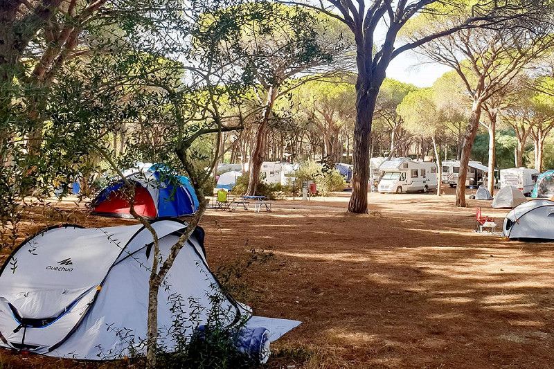
Camping Pedra e Cupa is located on the north coast of Sardinia, less than fifty meters from the Mediterranean Sea. Here the rocky coast of Sardinia gives way to a beautiful sandy beach where you can sunbathe and swim. At the campsite you can camp in the shade of the awnings and pine trees or in one of the mobile homes. With the swimming pool and the sea within easy reach, you can enjoy the water and the sun all holiday long. show less Camping in the shade
Most pitches are covered with an awning. Some pitches are in the shade of pine trees. The pitches are not particularly large and rather simple, but otherwise neatly laid out. In a separate part of the campsite there are around thirty rental accommodation units of various sizes