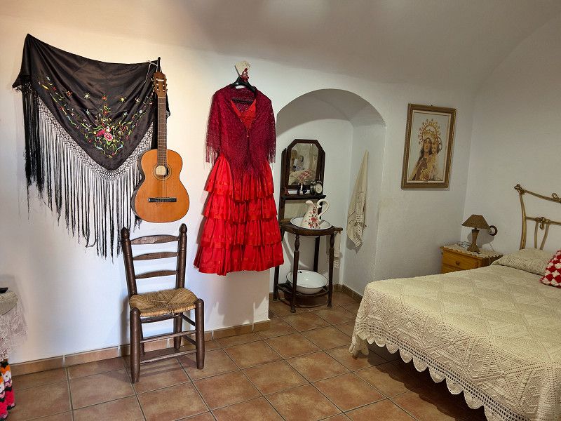
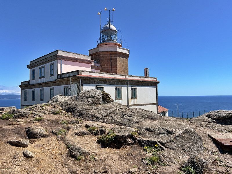
We spent three months traveling in Spain and Portugal, mostly along the coast. We traveled to many places, visited parking and camping sites and experienced a lot. We're sharing all of this with you. If you like our travel description, check out our YouTube channel, where we document our trip in videos. You can also follow us on Instagram and Facebook.
Best wishes
Carmen and Michael
NANUQ ON TOUR
Mein Standort
Danziger Platz, Frankfurt, Hesse, Germany
50° 6' 45.9" N 8° 42' 22.7" E
50.1127542 8.7063153
• Head toward Louis-Appia-Passage on Ostbahnhofstraße (B3). Go for 149 m.
• Turn left onto Ernst-Achilles-Platz (B3) toward Hanau/A661. Go for 65 m.
• Turn left onto Hanauer Landstraße (B3). Go for 139 m.
• Turn left onto Hanauer Landstraße (B3) toward Hanau/A661/Osthafen. Go for 2.0 km.
• Take ramp onto A661 toward Darmstadt/Flughafen F. Kreuz/Offenbach. Go for 5.4 km.
• Take exit 17 toward Köln/Wiesbaden/Flughafen F. Kreuz onto A3. Go for 8.5 km.
• Take exit 50 toward Basel/Darmstadt onto A5. Go for 23.6 km.
• Take the exit toward Basel/Karlsruhe onto A5. Go for 267 km.
• Take exit 66 toward Lyon/Mulhouse/Flughafen Euro onto A5/A36. Go for 608 m.
• Continue on A36 (La Comtoise). Go for 45.7 km.
• Take exit 14.1 toward Fontaine. Go for 366 m.
• Continue toward D31. Go for 365 m.
• Continue on D31. Go for 437 m.
• Take the 3rd exit from roundabout onto D60. Go for 944 m.
• Continue toward D31. Go for 41 m.
• Take the 2nd exit from roundabout onto D12 toward Paris/Lyon/Belfort/Lagrange. Go for 458 m.
• Take the 1st exit from roundabout toward Lagrange/Bethonvilliers. Go for 60 m.
• Continue on Rue de l'Escarcette (D12). Go for 805 m.
• Continue on Rue des Grands Champs (D12). Go for 345 m.
• Continue on D12. Go for 884 m.
• Turn left onto D83. Go for 560 m.
• Take the 2nd exit from roundabout onto Rue de la Baume (D83). Go for 768 m.
• Take the 1st exit from roundabout onto Rue de l'Étang (D12) toward Anjoutey/Étueffont/Giromagny/Ballon d'Alsace. Go for 2.4 km.
• Arrive at Rue des Errues (D12). Your destination is on the left.
☍
361,5 km
(3 hrs. 16 min.)
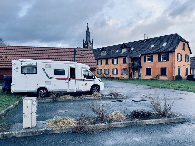
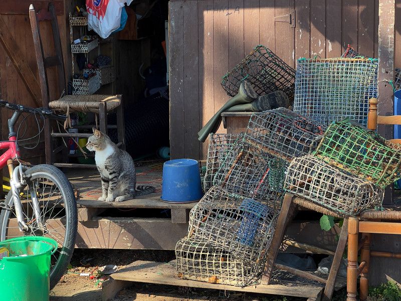
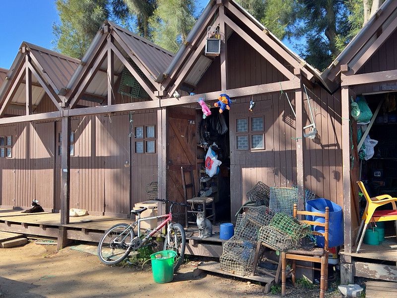
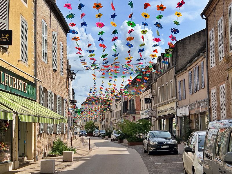
Anschatingen
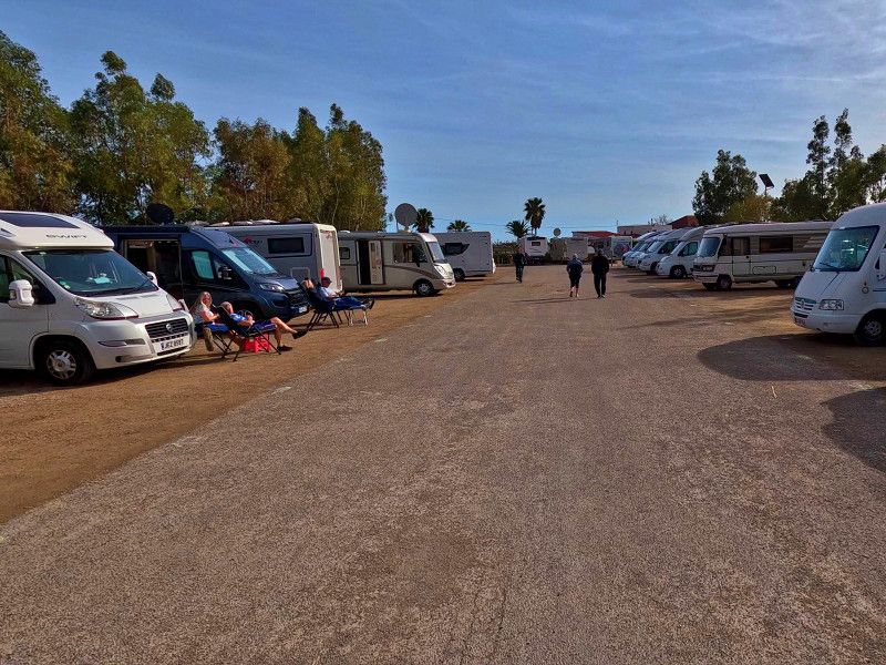
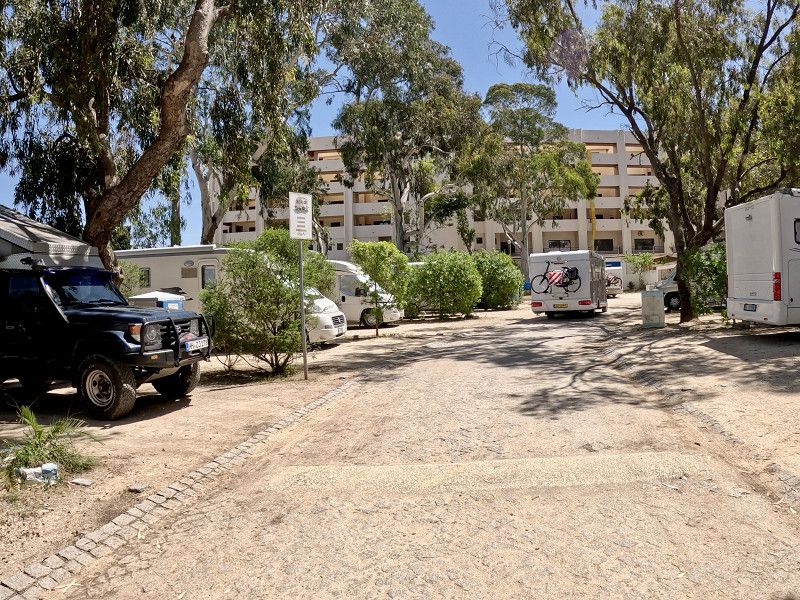
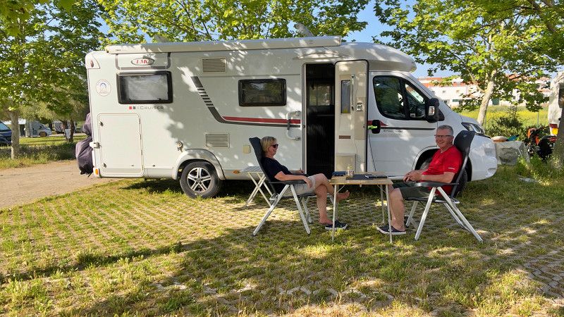
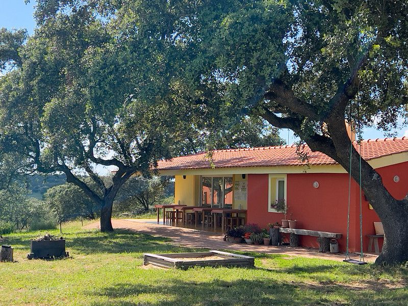
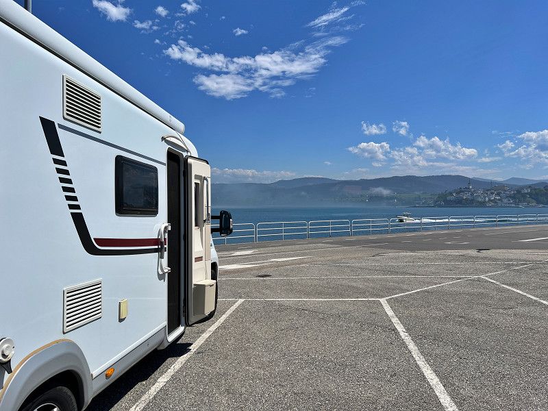
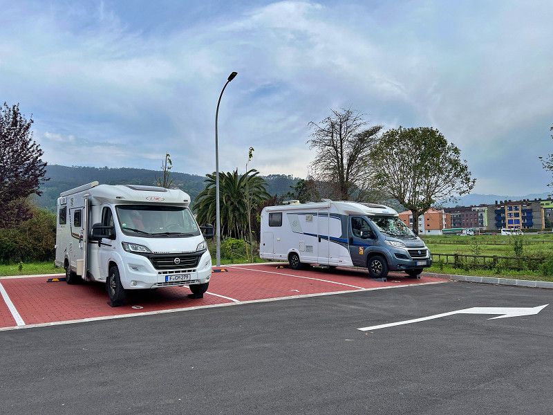
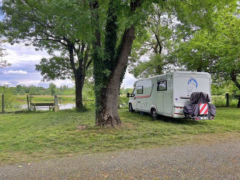
Today, after a month's delay, we finally set off. We set off on our big camper van trip through Spain and Portugal. Our first stop on the way to Soania is a small parking space for three mobile homes next to a pizzeria. The place is very quiet and free, but electricity (€5 for 55 minutes) and water (€5 for 10 minutes) are quite expensive. But since we only need to stock up on water, €5 for overnight accommodation and water is absolutely fine.
Rue des Errues 6, Anschatingen, Territoire-de-Belfort, Burgund und Freigrafschaft, Frankreich
47° 42' 1.1" N 6° 56' 0.1" E
47.7003188 6.9333706
• Head west on Rue des Errues (D12). Go for 86 m.
• Turn right onto Route de Bourg-sous-Châtelet (D27). Go for 177 m.
• Turn right toward Rue des Errues/D12. Go for 20 m.
• Turn left onto Rue des Errues (D12). Go for 2.2 km.
• Take the 2nd exit from roundabout onto Rue de la Baume (D83) toward A36/Belfort/Roppe. Go for 4.5 km.
• Take ramp onto D1083 toward E54/Belfort/A36/Montbéliard/Vesoul. Go for 1.7 km.
• Take ramp onto A36 (La Comtoise) toward Paris/Lyon/Montbéliard. Go for 145 km.
• Take the exit toward Lyon/Lons le S./Dole/Choisey onto A39 (Autoroute Verte). Go for 113 km.
• Continue on A40. Go for 22.4 km.
• Continue on A42 toward Grenoble/Chambéry/Lyon/Aéroport Saint-Exupéry. Go for 48.9 km.
• Take the left exit toward Marseille/Grenoble/Lyon/N346 onto A42. Go for 990 m.
• Take the exit toward Lyon onto A42. Go for 3.6 km.
• Take the left exit toward Marseille/Grenoble/Périphérique Sud/Porte de Cusset onto D383 (Boulevard Laurent Bonnevay). Go for 6.0 km.
• Keep left onto Boulevard Laurent Bonnevay (D383) toward St Étienne/Marseille/Vénissieux. Go for 1.9 km.
• Keep left onto Boulevard Laurent Bonnevay (D383) toward Paris/Saint-Étienne/Marseille/Lyon-Centre/Vénissieux-Centre. Go for 3.3 km.
• Keep left onto D383 toward Paris/Marseille/Saint-Étienne/Pierre Bénite/Saint Fons-Centre/Port E. Herriot. Go for 2.3 km.
• Keep left onto Boulevard Pierre Sémard (D383) toward A7/Paris/Lyon/Pierre-Bénite/Marseille/St Étienne/Vénissieux/Feyzin. Go for 188 m.
• Take ramp onto A7 (Autoroute du Soleil) toward St Étienne/Feyzin/Marseille. Go for 12.6 km.
• Take the exit toward Givors/St Étienne/Clermont-Fd/Chasse S/R. onto A47. Go for 12.9 km.
• Take exit 11 toward Rive de Gier/St Martin La Plaine. Go for 262 m.
• Continue on Route de Givors (D488) toward St Maurice S/D./Mornant/Brignais/Rive de Gier/St Étienne. Go for 987 m.
• Take the 1st exit from roundabout onto D488 toward St Étienne/St Martin la Pne/Rive de Gier. Go for 164 m.
• Take the 2nd exit from roundabout onto Rue des Martyrs de la Résistance (D88) toward Rive de Gier. Go for 71 m.
• Continue on M88. Go for 238 m.
• Take the 1st exit from roundabout onto Route du 3 Juillet 1867 (M37) toward D37/St Joseph/St Martin La Plaine. Go for 2.5 km.
• Turn left onto M30 toward D30/St Martin La Plaine/Rive de Gier. Go for 61 m.
• Continue on Route de Cellieu (M30). Go for 174 m.
• Take the 1st exit from roundabout onto Route de Cellieu (M37) toward D37/St Martin La Plaine. Go for 1.1 km.
• Continue on Route de l'Europe (M37). Go for 588 m.
• Take the 2nd exit from Rue Paul Verlaine roundabout onto Boulevard de Verdun (M37) toward St Martin La Plaine-Centre/D37/St Martin/La Plaine-Centre. Go for 288 m.
• Turn right onto Rue Antoine Marrel (M77) toward Genilac-la Cula/Ste Catherine. Go for 198 m.
• Turn left onto Place de l'Église (M77). Go for 142 m.
• Continue on Rue Antoine Seytre (M77). Go for 27 m.
• Turn left onto Rue Antoine Seytre (M37) toward D37/Genilac-la Cula/St Romain en Jarez. Go for 649 m.
• Continue on Route de Cellieu (M37). Go for 112 m.
• Arrive at Route de Cellieu (M37). Your destination is on the right.
☍
389,5 km
(3 hrs. 35 min.)
Saint-Martin-la-Plaine
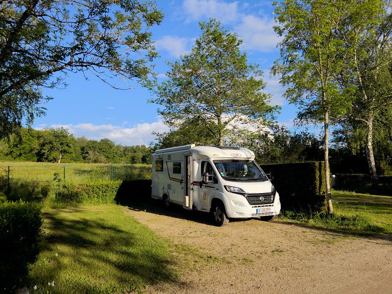
We drove on. But just before Besançon we abandoned our plan to drive to Spain without paying tolls. The roads are bad, there are lots of small towns with 30 km/h zones, roundabouts and people with a lot of time on their hands. So we got on the motorway and went to our second overnight spot near a zoo. We'll see when the animals wake up in the morning.
The site is one of the many "Camping-Car Park" sites in France and can only be used with the relevant card. You can get it at www.campingcarpark.com.
Rue Antoine Seytre, Saint-Martin-la-Plaine, Loire, Auvergne-Rhone-Alpen, Frankreich
45° 32' 56.6" N 4° 35' 5.2" E
45.5490517 4.5847691
• Head northeast on Route de Cellieu (M37). Go for 112 m.
• Continue on Rue Antoine Seytre (M37). Go for 649 m.
• Continue on Rue Antoine Seytre (M77) toward D77/A47/Rive de Gier. Go for 19 m.
• Turn right onto Rue Charles Meley. Go for 100 m.
• Turn left onto Rue Marrel-Bertholon. Go for 226 m.
• Continue on Place de la Bascule. Go for 10 m.
• Turn right onto Rue Antoine Marrel (M77). Go for 69 m.
• Turn left onto Boulevard de Verdun (M37) toward D37/A47/St Joseph/Rive de Gier. Go for 259 m.
• Take the 3rd exit from Rue Paul Verlaine roundabout onto Route de l'Europe (M37) toward A47/St Joseph/Rive de Gier. Go for 615 m.
• Continue on Route de la Plaine (M37). Go for 1.1 km.
• Take the 2nd exit from roundabout onto Route de Cellieu (M30) toward D30/A47/St Joseph/La Madeleine. Go for 244 m.
• Continue on M30 toward A47/St Joseph/La Madeleine. Go for 42 m.
• Turn right onto Route de Cellieu (M37) toward D37/A47/La Madeleine. Go for 2.5 km.
• Take the 2nd exit from roundabout onto Rue des Martyrs de la Résistance (M88). Go for 286 m.
• Continue on Rue des Martyrs de la Résistance (D88) toward Givors/Lyon/St Maurice S/D./Mornant/Brignais. Go for 19 m.
• Take the 2nd exit from roundabout onto D488 toward Givors/Lyon/Brignais/Mornant. Go for 178 m.
• Take the 3rd exit from roundabout onto Route de Givors (D88/D488) toward Givors/Lyon. Go for 867 m.
• Turn right onto D502 toward Trèves/Vienne/Condrieu/Longes/Les Haies/Givors/Lyon. Go for 239 m.
• Take left ramp onto A47 toward Lyon/Valence. Go for 12.6 km.
• Take the exit toward Vienne/Valence/Marseille onto A7 (Autoroute du Soleil). Go for 176 km.
• Keep right onto A9 (Échangeur d'Orange) toward Barcelone/Toulouse/Montpellier/Nîmes. Go for 219 km.
• Take exit 40 toward Salses le Ch./Port-Leucate/Leucate. Go for 883 m.
• Continue on D627. Go for 2.4 km.
• Pass 2 roundabouts and continue on D627. Go for 14.5 km.
• Continue on D83. Go for 1.7 km.
• Take ramp toward Coudalère/Grande Plage. Go for 151 m.
• Take the 3rd exit from Rond-Point Coudalère roundabout. Go for 288 m.
• Take the 1st exit from Rond-Point Pierre Mendès France roundabout onto Avenue du Roussillon (D90). Go for 176 m.
• Continue on Avenue du Lido (D90). Go for 1.4 km.
• Take the 2nd exit from roundabout onto Avenue Annibal (D90). Go for 625 m.
• Take the 3rd exit from Rond-Point Annibal roundabout onto Avenue Annibal (D90). Go for 715 m.
• Take the 1st exit from Rond-Point de l'Appel du 18 Juin 1940 roundabout. Go for 429 m.
• Arrive at your destination on the left.
☍
438,6 km
(3 hrs. 58 min.)
Le Barcarès
We've called it a day. We've chosen a nice parking spot by the harbor with a view of the water. It was a good decision, because we wouldn't have gotten much further anyway, as the border to Spain was closed; protests from farmers and truck drivers. Nothing more could be done.
The pitch currently costs €8/24h, electricity costs €5/24h, showers and toilets are free. There are sufficient supplies and disposal facilities.
Quai Alain Colas, Le Barcarès, Ostpyrenäen, Okzitanien, Frankreich
42° 48' 5.7" N 3° 1' 58.2" E
42.8015890 3.0328302
• Head east. Go for 375 m.
• Take the 1st exit from Rond-Point de l'Appel du 18 Juin 1940 roundabout onto Avenue Charles de Gaulle (D90). Go for 416 m.
• Take the 1st exit from roundabout onto Boulevard du Port (D90). Go for 160 m.
• Take the 2nd exit from roundabout onto Boulevard du Port (D90). Go for 345 m.
• Take the 2nd exit from Rond-Point des Déportés et des Résistants roundabout onto Cours de la Méditerranée. Go for 112 m.
• Pass 2 roundabouts and continue on Cours de la Méditerranée. Go for 977 m.
• Take ramp onto D83 toward A9. Go for 10.9 km.
• Take the 2nd exit from roundabout onto D83 toward Barcelone/Toulouse/Montpellier/Narbonne. Go for 207 m.
• Take ramp onto A9 (La Catalane) toward Barcelone. Go for 39.8 km.
• Continue on AP-7 (Autopista de la Mediterrània). Go for 64.3 km.
• Take exit 7 toward Girona S./St. Feliu de Guíxols. Go for 680 m.
• Continue on Carretera de Girona a Sant Feliu de Guíxols (C-65). Go for 331 m.
• Take the 2nd exit from roundabout toward Salt. Go for 654 m.
• Take the 1st exit from roundabout onto Avinguda de la Pau toward Centre Urbà/Girona Centre/Hospital de Salt. Go for 455 m.
• Pass 2 roundabouts and continue on Avinguda de la Pau. Go for 714 m.
• Arrive at Avinguda de la Pau. Your destination is on the right.
☍
120,5 km
(1 hrs. 10 min.)
Girona
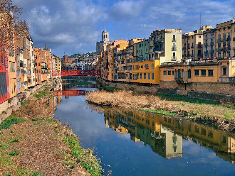
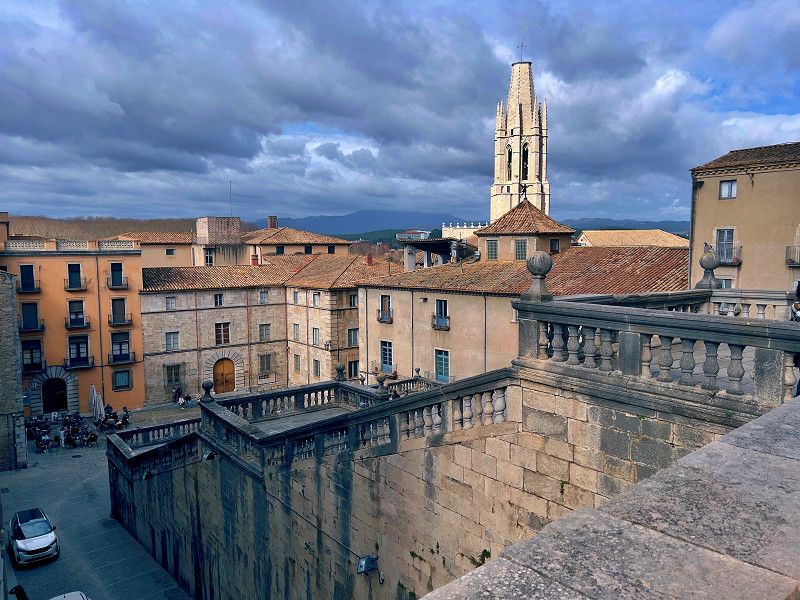
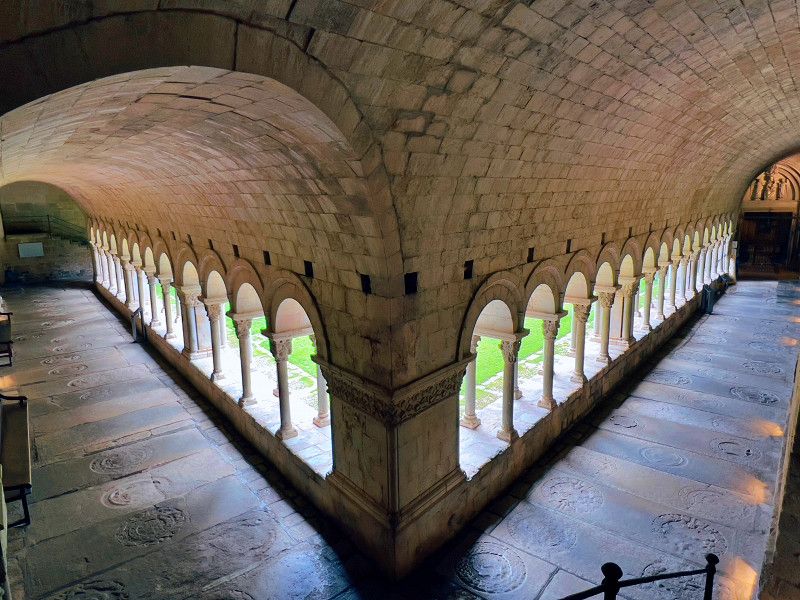
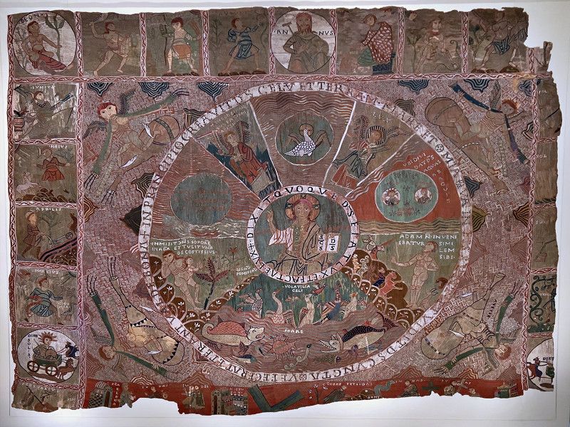
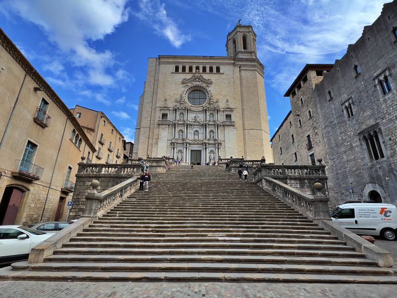
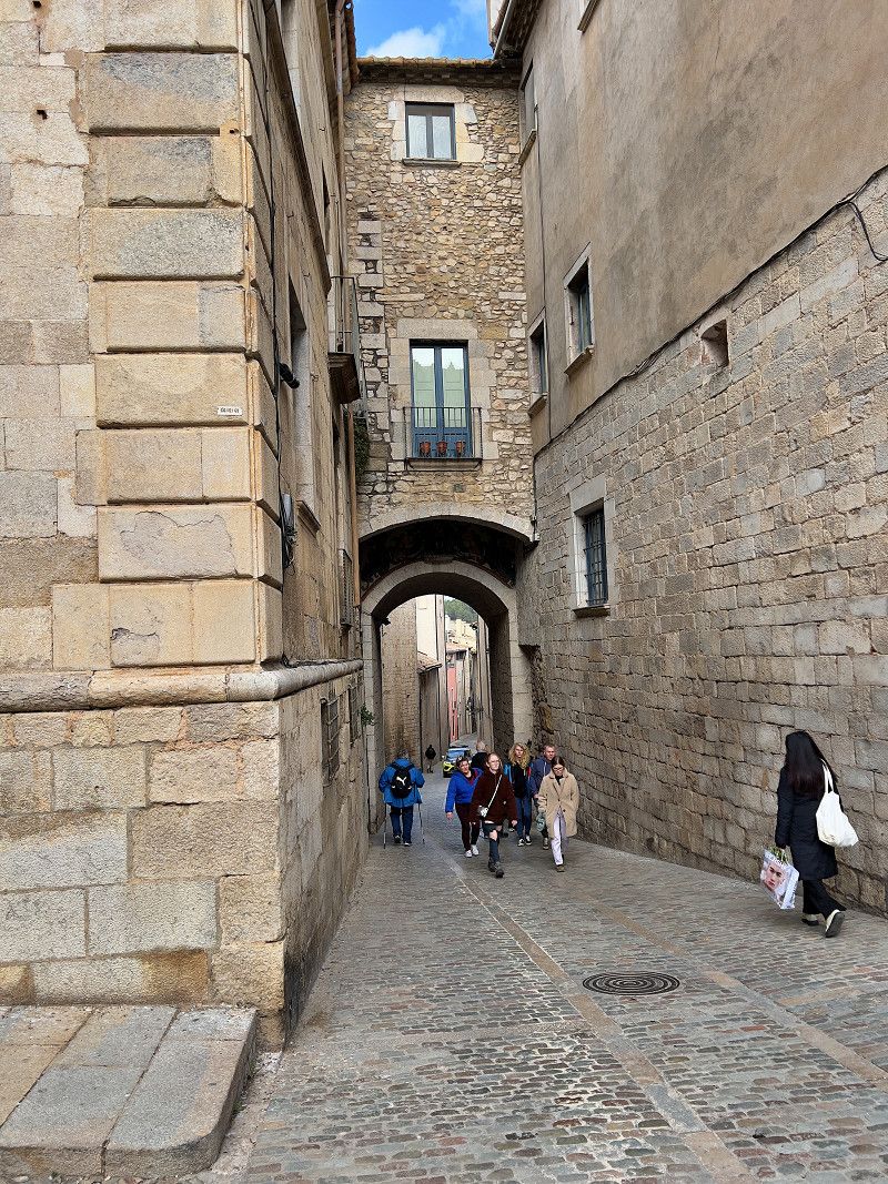
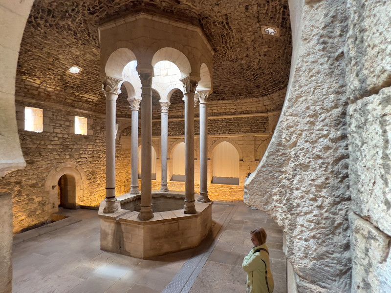
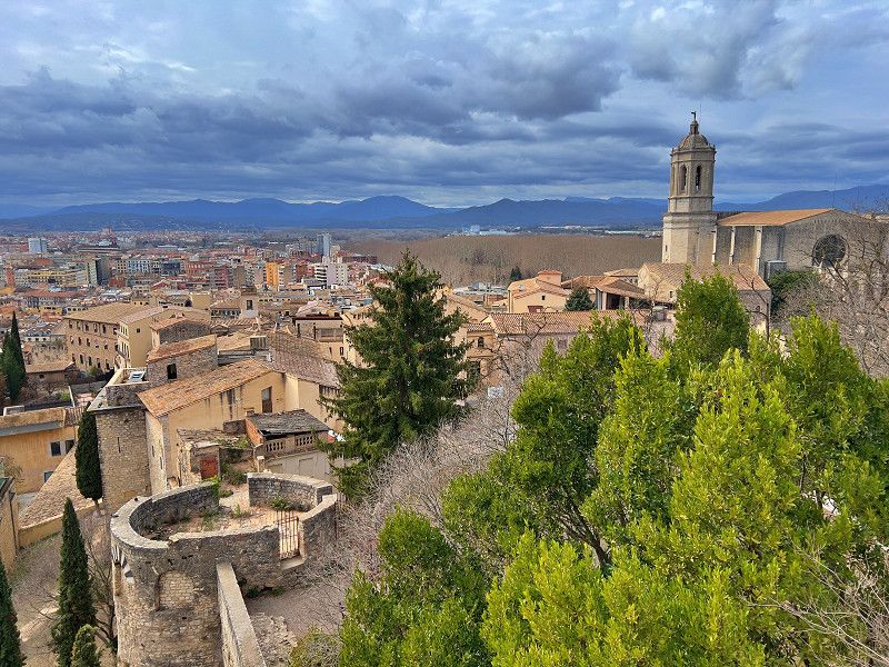
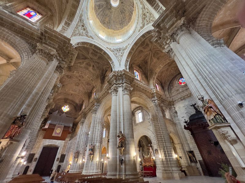
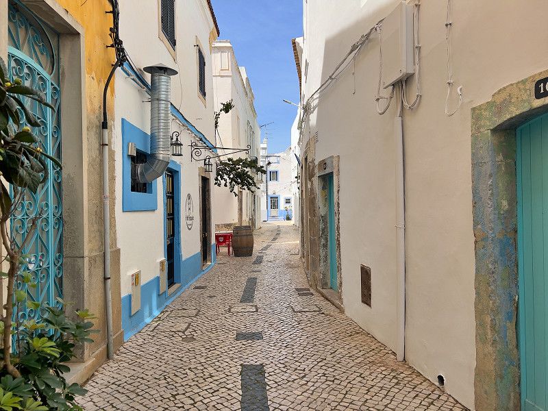
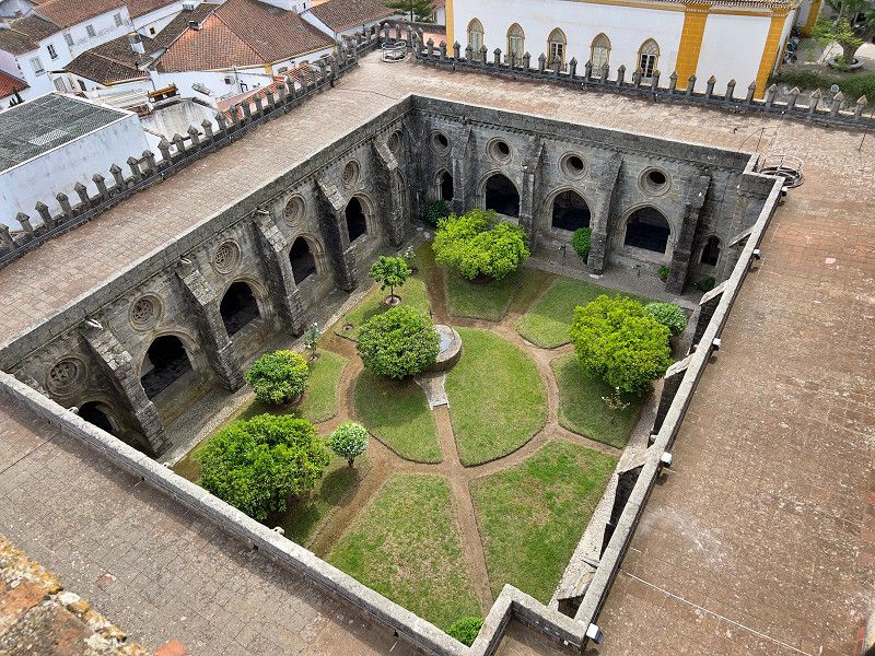
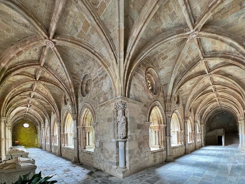
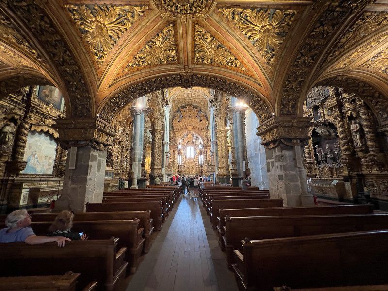
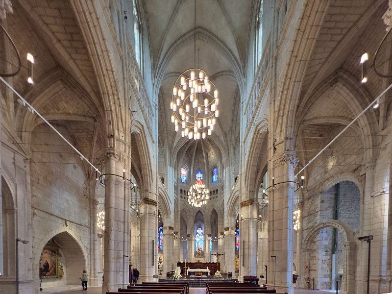
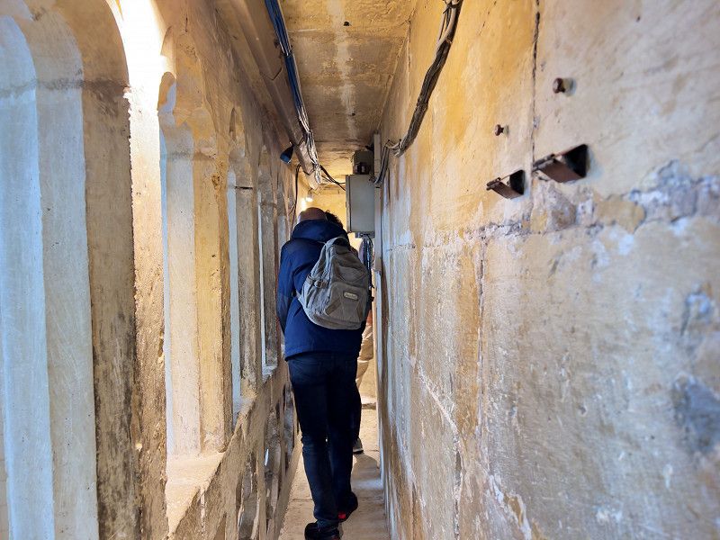
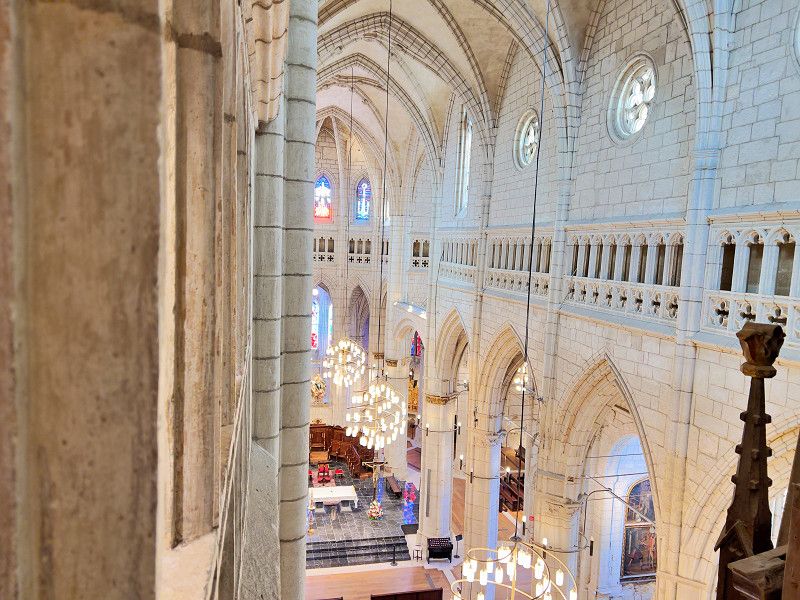
We parked at this paid parking space (water/gas, shower/toilet, electricity), which is guarded 24 hours a day, to see Girona. It is a 37-minute walk to the old town (it would have taken almost as long by bus, but it is 14 minutes by bike). Girona is absolutely worth seeing - the narrow, winding alleys, the imposing cathedral with the largest column-free vault in Europe and the almost 1,000-year-old carpet that tells the story of creation. Or the Arab bath or the city wall, from which you have a wonderful view of the city. And don't forget the small cafes and tapas bars.
Avinguda de la Pau, Speisesalz, Girona, Spanien
41° 58' 6.4" N 2° 48' 2" E
41.9684500 2.8005520
• Head toward Carrer Montnegre on Avinguda de la Pau. Go for 97 m.
• Continue on Carrer Salt. Go for 578 m.
• Take the 2nd exit from Plaça Salt roundabout onto Carretera Santa Coloma (GI-533). Go for 749 m.
• Take the 1st exit from Rotonda de Santa Coloma de Farners roundabout onto Carrer de la Torre Vedruna toward Barcelona/La Jonquera/AP-7/Salt/Anglès. Go for 320 m.
• Take ramp onto Carretera de Girona a Sant Feliu de Guíxols (C-65). Go for 844 m.
• Take the 2nd exit from roundabout onto Carretera de Girona a Sant Feliu de Guíxols (C-65) toward E-15/AP-7/Barcelona/França/Francia. Go for 406 m.
• Keep left toward Barcelona. Go for 489 m.
• Take ramp onto AP-7 (Autopista de la Mediterrània). Go for 71.5 km.
• Keep right onto AP-7 (Autopista de la Mediterrània) toward Lleida/E-90/AP-2/Tarragona/Sabadell/C-58/Túnels de Vallvidrera/E-9/Manresa/C-16/Polígon Industrial de Zona Franca/Fira. Go for 47.2 km.
• Take exit 27 toward St. Sadurní d'Anoia/Subirats. Go for 1.0 km.
• Take the 2nd exit from roundabout onto BP-2427 toward Polígon Industrial de Subirats/St. Sadurní d'Anoia/Gelida. Go for 375 m.
• Take the 1st exit from roundabout onto BP-2427 toward St. Sadurní de l'Heura/Gelida/St. Sadurní A./Igualada. Go for 1.3 km.
• Continue on BV-2244. Go for 363 m.
• Take the 1st exit from roundabout onto Passatge Can Codorniu. Go for 644 m.
• Turn slightly right toward Plaça del Roure. Go for 19 m.
• Continue on Plaça del Roure. Go for 66 m.
• Arrive at your destination on the right.
☍
126,0 km
(1 hrs. 11 min.)
Sant Sadurní d'Anoia
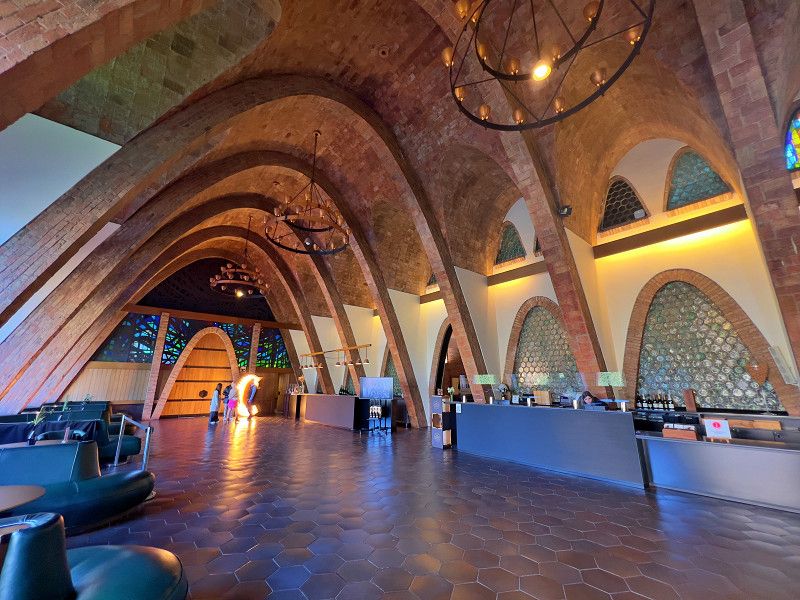
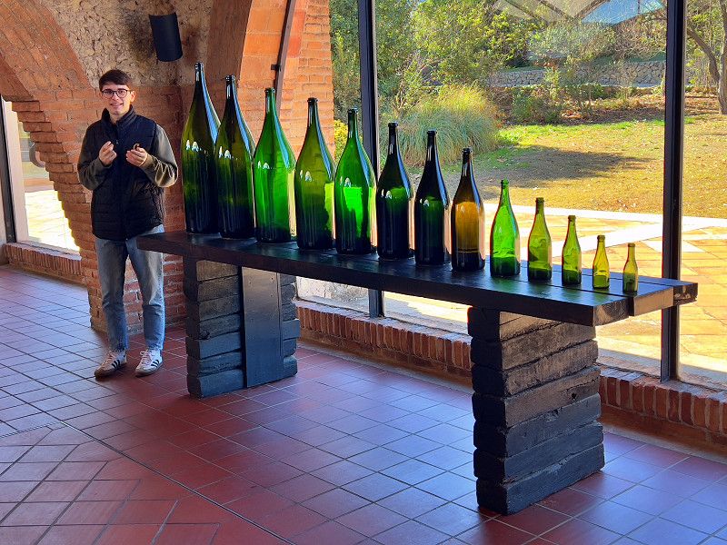
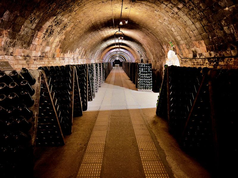
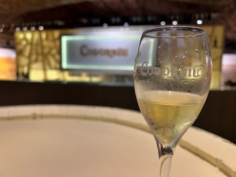
Cava, the Spanish sparkling wine, comes from the area around Barcelona. We decided to visit a winery. Codorniu was founded in 1551 and Cava has been produced there since 1872. At 30 km long, it has the largest wine cellar in the world. During a guided tour, you can learn a lot about the history of the family, the architecture of the buildings (all listed buildings) and the production of sparkling wine. After a "train ride" through part of the cellars, a tasting concludes the tour.
Variant de Sant Sadurní d'Anoia, Sant Sadurní d'Anoia, Alt Penedès, Katalonien, Spanien
41° 26' 3.2" N 1° 47' 46.1" E
41.4342150 1.7961368
• Head south. Go for 33 m.
• Continue on Plaça del Roure. Go for 151 m.
• Continue on Passatge Can Codorniu. Go for 523 m.
• Take the 3rd exit from roundabout onto Carretera de Sant Sadurní d'Anoia (BV-2244). Go for 424 m.
• Continue on BP-2427. Go for 1.2 km.
• Take the 2nd exit from roundabout onto BP-2427 toward E-15/E-90/AP-7/Barcelona/Girona/Lleida/Tarragona/N-340/Ordal. Go for 338 m.
• Take the 1st exit from roundabout onto AP-7 (Autopista de la Mediterrània) toward Lleida/Tarragona. Go for 139 km.
• Take exit 41 toward Amposta/N-340/La Ràpita. Go for 2.2 km.
• Take the 2nd exit from roundabout onto N-340a toward N-340/Castelló/Tarragona. Go for 901 m.
• Take the 1st exit from roundabout onto N-340 toward Amposta S/Sant Carles de la Ràpita/Castelló. Go for 2.7 km.
• Take ramp toward TV-3403/Amposta/Sant Jaume d'Enveja/els Muntells/TV-3405. Go for 313 m.
• Turn right onto Avinguda de Sant Jaume (TV-3405) toward TV-3403/Sant Jaume d'Enveja/els Muntells/Platges d'Amposta/Urb. Eucaliptus/Poble nou del Delta. Go for 162 m.
• Continue on TV-3405 toward TV-3403/Sant Jaume d'Enveja/els Muntells. Go for 2.6 km.
• Continue on TV-3403. Go for 19 m.
• Continue on TV-3405. Go for 1.1 km.
• Take the 3rd exit from roundabout onto TV-3405 toward St. Jaume E./Deltebre/els Muntells. Go for 611 m.
• Turn right onto TV-3405 toward els Muntells. Go for 5.8 km.
• Turn right onto TV-3406 toward Sant Carles de la Ràpita. Go for 3.1 km.
• Turn left onto Camí de Pescadors. Go for 2.6 km.
• Turn slightly left. Go for 34 m.
• Arrive at your destination on the left.
☍
163,7 km
(1 hrs. 31 min.)
Amposta
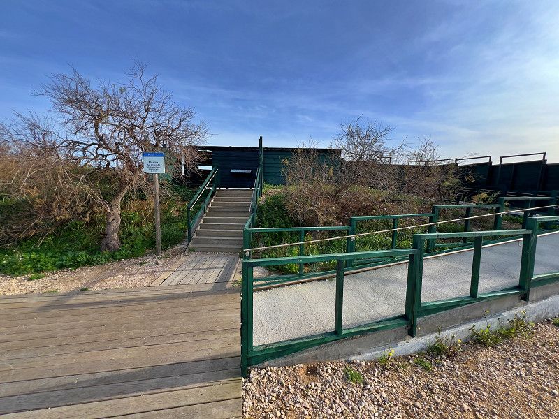
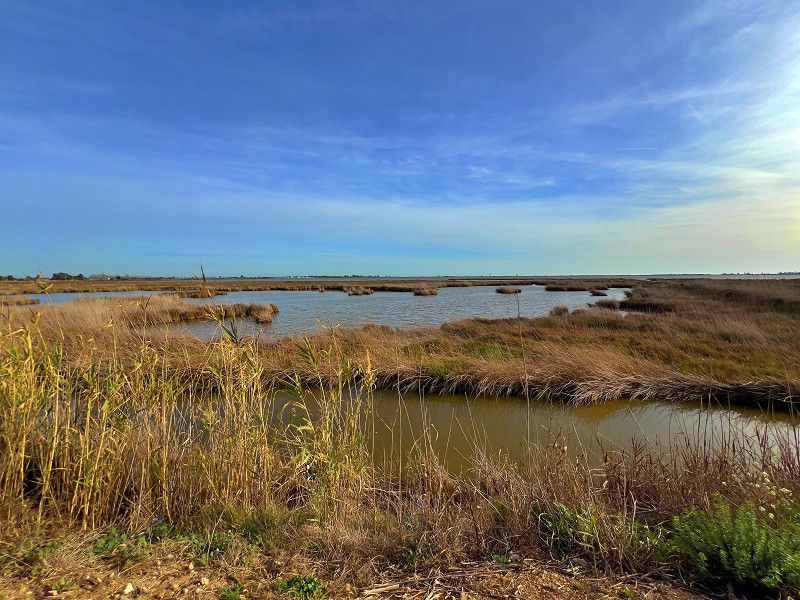
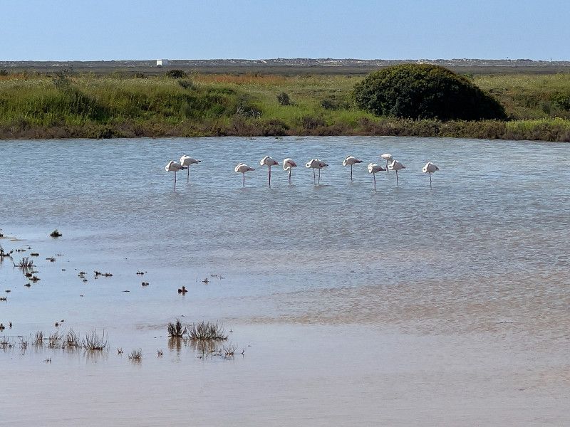
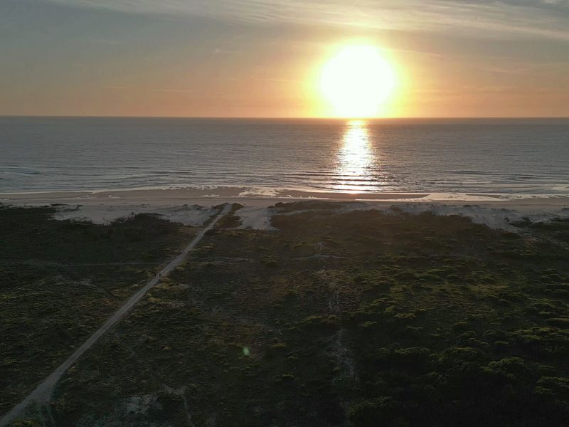
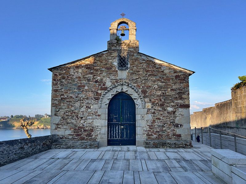
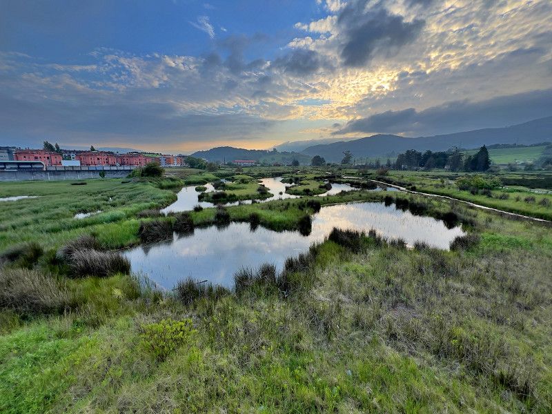
We were drawn to the Ebro Delta. There, where Spain's longest river (1,000 km) flows into the sea in a wide river delta, there is a huge nature reserve. A stopover for many migratory birds. And a center of rice cultivation. An ideal place for bike tours. On our first tour we saw flamingos. Unfortunately only with binoculars; too far away for photos. But maybe we'll be lucky tomorrow.
Camí de les Casetes, Amposta, Montsià, Katalonien, Spanien
40° 39' 32.4" N 0° 40' 31" E
40.6590135 0.6752784
• Head toward Camí de Pescadors. Go for 34 m.
• Turn slightly right onto Camí de Pescadors. Go for 2.6 km.
• Turn left onto TV-3406. Go for 6.7 km.
• Take the 3rd exit from roundabout onto TV-3406 toward Amposta/Castelló. Go for 433 m.
• Continue on Camí Salt (TV-3406). Go for 193 m.
• Turn right onto Camí Salt. Go for 12 m.
• Take left ramp onto N-340 toward Sant Carles de la Ràpita sud/Castelló. Go for 3.1 km.
• Pass 2 roundabouts and continue on N-340. Go for 32.4 km.
• Take ramp toward Peñíscola. Go for 428 m.
• Take the 3rd exit from roundabout onto CV-141 toward Peñíscola. Go for 274 m.
• Continue on Avenida de la Estación (CV-141). Go for 3.5 km.
• Pass 2 roundabouts and continue on Avenida de la Estación (CV-1410). Go for 1.7 km.
• Take the 3rd exit from roundabout toward Carrer de Tramuntana. Go for 156 m.
• Continue on Camino Peñíscola a Benicarló. Go for 109 m.
• Turn left onto Camino Peñíscola a Benicarló. Go for 70 m.
• Arrive at Camino Peñíscola a Benicarló. Your destination is on the left.
☍
51,6 km
( 40 min.)
Parking La Brisa, Peníscola, Spanien
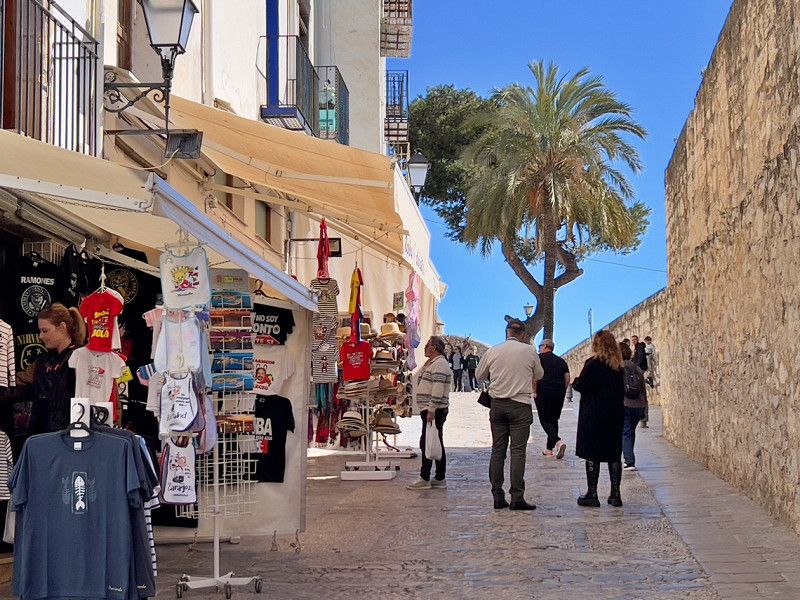
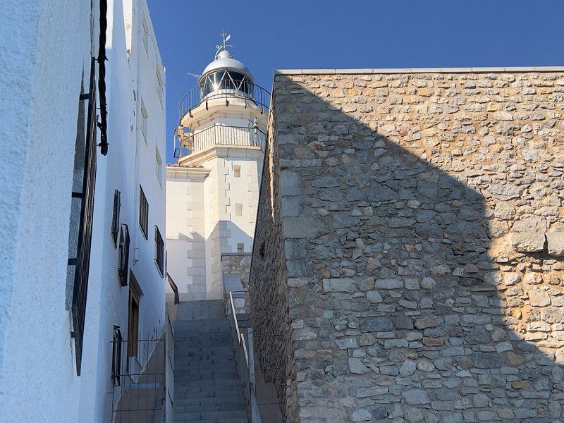
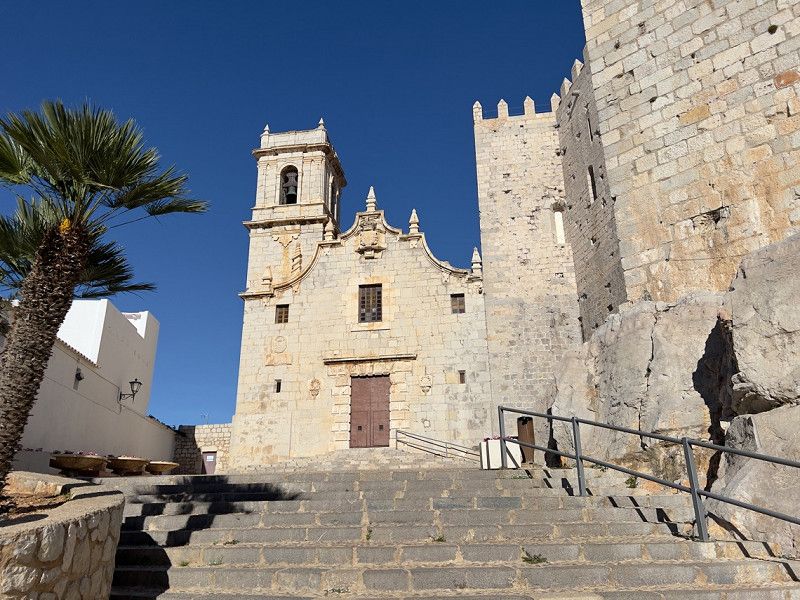
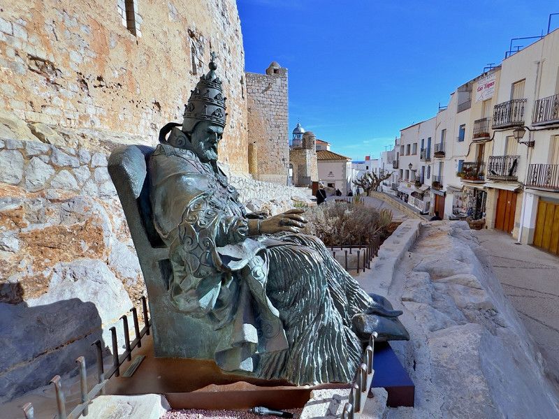
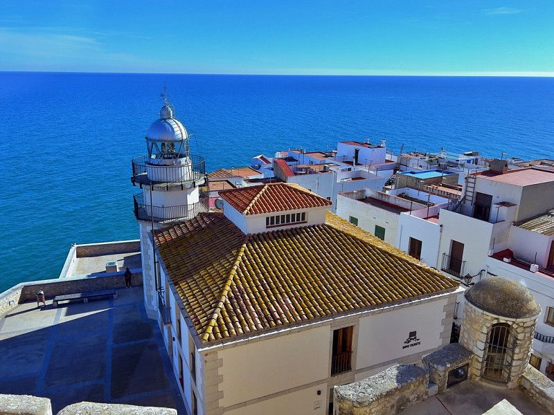
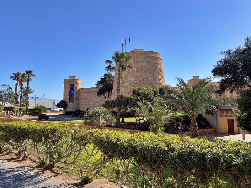
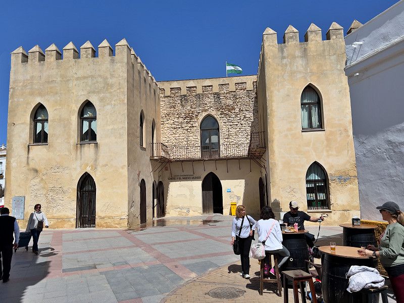
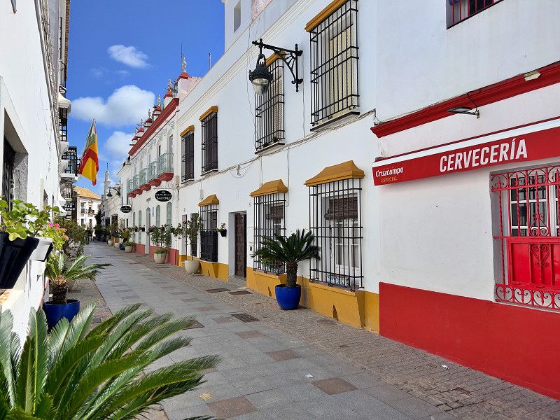
We took a look at Peñiscola, or more precisely the old town. It is part of the association of the 104 most beautiful villages in Spain and is dominated by the castle, which was the last castle that the Knights Templar completed in 1307 before the order was disbanded. Don Pedro de Luna found his exile here as Pope Benedict XIII, where he ultimately died. The old town with its narrow streets is absolutely worth seeing, as is the castle. And from it, the highest point on the peninsula, we have a fantastic view of the city and the surrounding area.
Vía Polígono 7, 11, 12598 Peníscola, Castelló, Spanien
40° 21' 59.3" N 0° 23' 47.9" E
40.3664632 0.3966254
• Head toward Calle Pigmalión on Camino Peñíscola a Benicarló. Go for 70 m.
• Turn right onto Camino Peñíscola a Benicarló. Go for 176 m.
• Take the 1st exit from roundabout onto Avenida de la Estación (CV-1410) toward N-340/E-15/AP-7/Castelló/Tarragona/Benicarló. Go for 310 m.
• Take the 3rd exit from roundabout onto Avenida de la Estación (CV-141) toward E-15/AP-7/Castelló/Tarragona. Go for 1.3 km.
• Take the 3rd exit from roundabout onto Avenida de la Estación (CV-141). Go for 3.6 km.
• Continue on CV-141 toward Benicarló/Tarragona/E-15/AP-7/Valencia/Barcelona. Go for 70 m.
• Take the 2nd exit from roundabout onto N-340 toward Benicarló/Tarragona/E-15/AP-7/Valencia/Barcelona. Go for 1.8 km.
• Take ramp toward N-340a/Benicarló sud/Benicarló Sur/Castelló/Castellón/E-15/AP-7/Tarragona. Go for 332 m.
• Take the 1st exit from roundabout onto AP-7 (Autopista del Mediterráneo) toward Valencia. Go for 90.0 km.
• Take exit 49 toward Moncofa/La Vall d'Uixó/Teruel/Nules/N-340/A-7. Go for 571 m.
• Take the 3rd exit from roundabout onto N-225 toward N-340/Castelló/Valencia/La Vall d'Uixó. Go for 4.3 km.
• Take the 2nd exit from roundabout toward A-7/Valencia/N-225/Teruel/La Vall d'Uixó. Go for 276 m.
• Continue toward La Vall d'Uixó. Go for 40 m.
• Take the 2nd exit from roundabout toward La Vall d'Uixó. Go for 101 m.
• Continue on Paseo del Mar Mediterráneo. Go for 112 m.
• Pass 2 roundabouts and continue on Calle Molino Marco. Go for 712 m.
• Take the 2nd exit from Calle Molino Marco roundabout onto Calle Andalucía toward Alfondeguilla/Segorbe. Go for 898 m.
• Continue on Carretera Segorbe. Go for 482 m.
• Take the 2nd exit from roundabout onto Carretera Segorbe. Go for 663 m.
• Continue on Carretera Alfondeguilla. Go for 599 m.
• Take the 3rd exit from roundabout onto Paseo de las Grutas toward Grutas San José. Go for 282 m.
• Turn slightly left. Go for 268 m.
• Turn left. Go for 158 m.
• Turn left. Go for 24 m.
• Arrive at your destination on the right.
☍
107,1 km
(1 hrs. 5 min.)
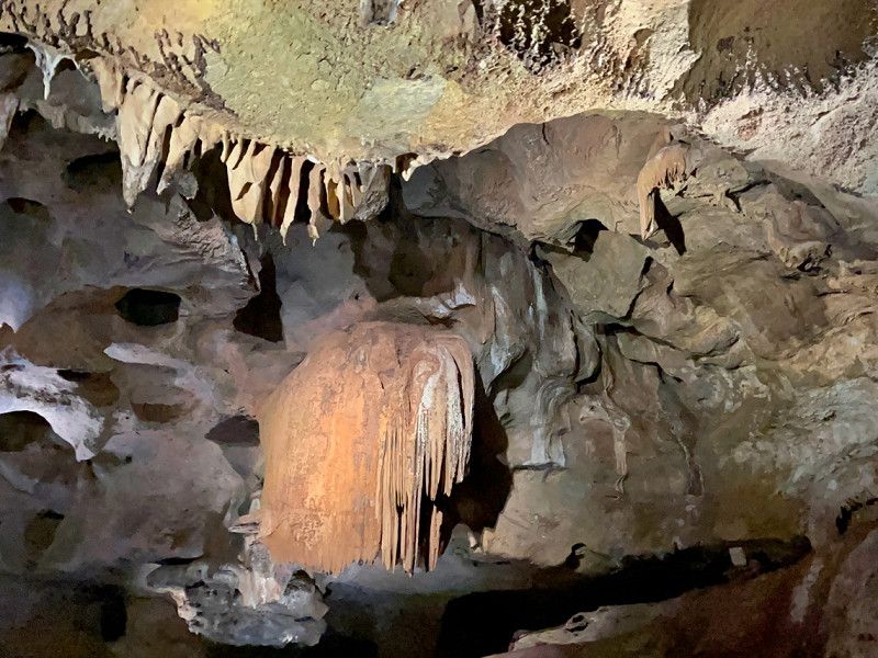
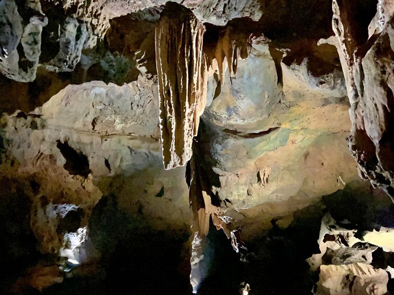
Cuevas San Jose
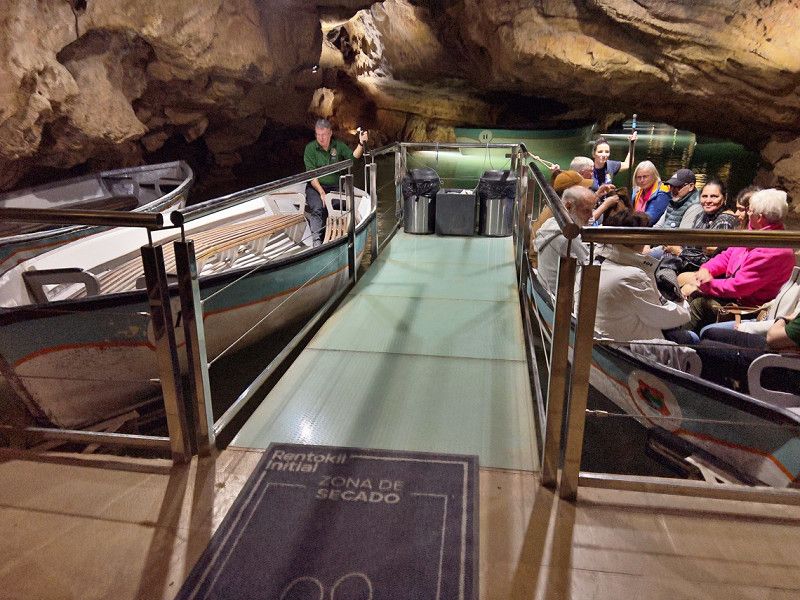
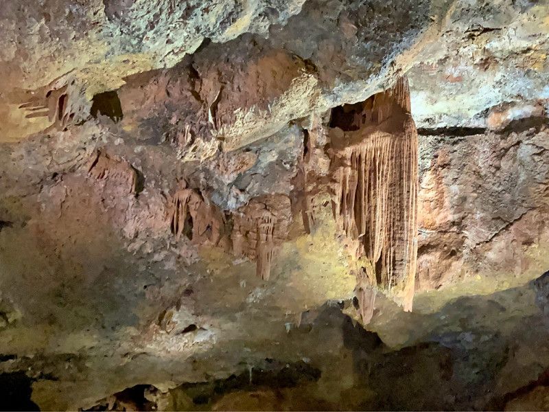
We continue south. But only a short distance. On the way to Valencia we look at the Coves de Sant Josep. It is a stalactite cave with the longest navigable underground river in Europe. There are several formations to marvel at, such as the jellyfish, the cascade, the crocodile and the dinosaur. The origin of the river and the end of the cave are still unknown. In the parking lot there is a free area for 8 mobile homes - we just managed to find a spot on an adjacent gravel area because we want to spend the night here. So many mobile homes...
Calle Guitarro, La Vall d'Uixó, Castellon, Spain
39° 49' 24.4" N 0° 14' 58" W
39.8234378 -0.2494349
• Head northwest.
• Turn slightly left. Go for 62 m.
• Turn left. Go for 46 m.
• Turn right. Go for 150 m.
• Turn right toward Paseo de las Grutas. Go for 17 m.
• Continue on Paseo de las Grutas. Go for 416 m.
• Take the 1st exit from roundabout onto Carretera a Las Grutas toward CV-230/Centre Ciutat Xilxes/A-7. Go for 686 m.
• Take the 3rd exit from roundabout onto Carretera a Las Grutas. Go for 1.1 km.
• Take the 2nd exit from roundabout onto Avenida Europa. Go for 108 m.
• Take the 1st exit from roundabout onto Calle Colonia Segarra toward N-225/Algar/Segorbe. Go for 33 m.
• Keep left onto Avenida Europa toward Valencia. Go for 195 m.
• Take the 2nd exit from roundabout onto Avenida Europa. Go for 526 m.
• Take the 2nd exit from roundabout onto Carretera de Chilches (CV-230). Go for 335 m.
• Take the 2nd exit from roundabout onto Carretera de Chilches (CV-230). Go for 121 m.
• Continue on Colonia Carmaday. Go for 33 m.
• Take the 2nd exit from roundabout onto Carretera de Chilches (CV-230). Go for 477 m.
• Take the 1st exit from roundabout onto Carretera de Chilches (CV-230) toward Xilxes/A-7/València. Go for 710 m.
• Take the 1st exit from roundabout toward A-7/Valencia/Castelló. Go for 101 m.
• Take the 2nd exit from roundabout onto A-7 (Autovía del Mediterráneo) toward Almenara/Valencia. Go for 12.2 km.
• Continue on AP-7 (Autovía del Mediterráneo). Go for 8.8 km.
• Keep left onto V-21 toward Valencia (Norte)/Puçol/V-23/Sagunt/Sagunto. Go for 19.6 km.
• Take the 2nd exit from Plaza Cardenal Vicente Enrique y Tarancón roundabout onto Avenida de Aragón toward Estadi Mestalla/Av. Aragón/Av. d'Aragó/Grans Víes. Go for 749 m.
• Take the 2nd exit from roundabout onto Avenida de Aragón. Go for 209 m.
• Take the 3rd exit from Plaza Zaragoza roundabout. Go for 90 m.
• Continue on Puente de Aragón. Go for 208 m.
• Continue toward Avenida Jacinto Benavente. Go for 48 m.
• Turn left onto Avenida Jacinto Benavente toward Alicante/Alacant/Madrid/A-3/Ciudad de las Artes y Las Ciencias/El Saler. Go for 719 m.
• Continue on Calle del Alcalde Reig toward Ciudad de las Artes y Las Ciencias/El Saler. Go for 532 m.
• Take the 2nd exit from roundabout onto Avenida Profesor López Piñero (V-15) toward Madrid/Aeropuerto/A-3/Hospital La Fe/Ciutat de les Arts i les Ciències. Go for 107 m.
• Keep left onto Avenida Profesor López Piñero (V-15). Go for 3.4 km.
• Continue on CV-500. Go for 4.2 km.
• Take the exit toward El Saler. Go for 1.0 km.
• Take the 1st exit from roundabout toward El Saler. Go for 66 m.
• Continue on Carrera del Río (CV-5010). Go for 218 m.
• Arrive at Carrera del Río (CV-5010). Your destination is on the right.
☍
57,4 km
( 42 min.)
Carrera del Riu, 556b, València, Spanien
Carrera del Riu, 556b, Poblados del Sur, 46012 Valencia, Spanien
39° 23' 12" N 0° 19' 55.2" W
39.3866620 -0.3320038
• Head south on Carrera del Río (CV-5010). Go for 102 m.
• Turn right. Go for 70 m.
• Turn right. Go for 25 m.
• Turn right. Go for 49 m.
• Turn right. Go for 24 m.
• Turn left toward Carrera del Río/CV-5010. Go for 19 m.
• Turn left onto Carrera del Río (CV-5010). Go for 138 m.
• Arrive at Carrera del Río (CV-5010). Your destination is on the left.
☍
0,4 km
( 1 min.)
Valencia
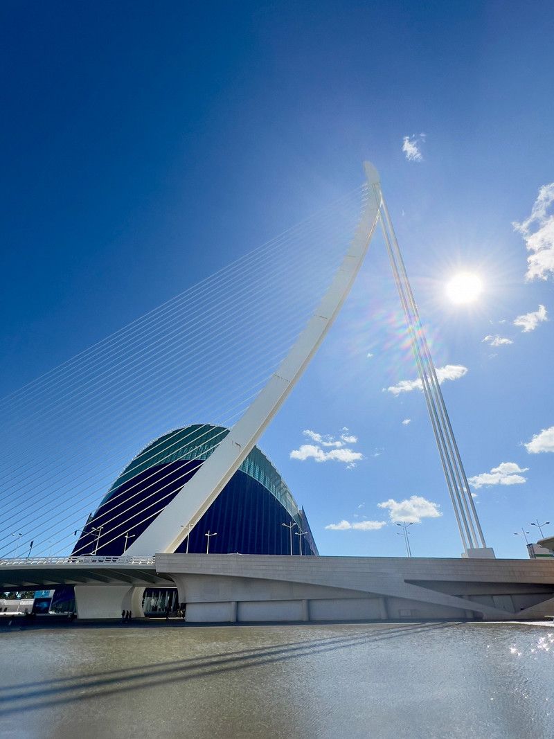
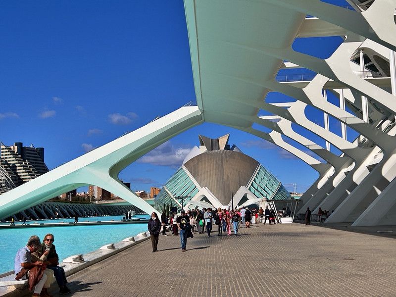
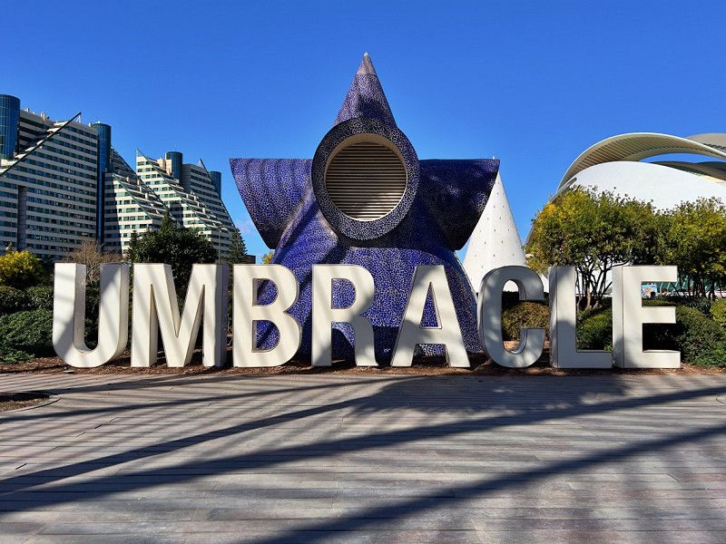
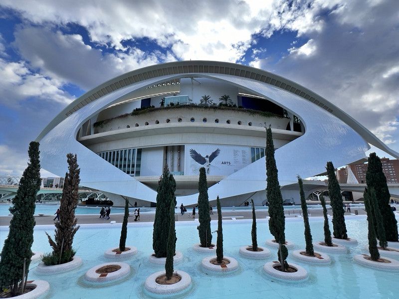
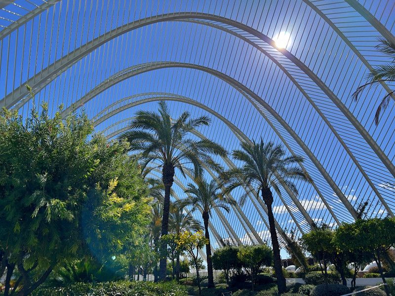
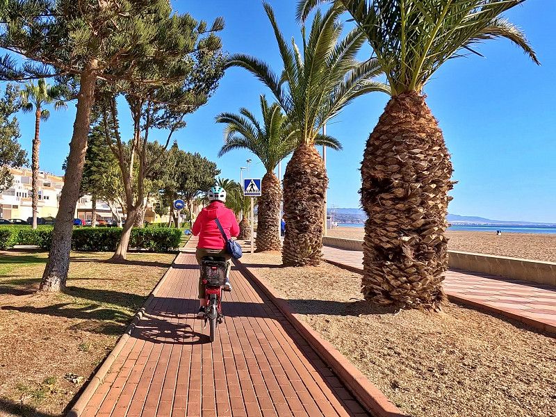
We are staying at the new Eco Area El Saler campsite for three days. From here, a well-developed cycle path leads along the beach to the city centre of Valencia, past the futuristic science city with museums, a botanical garden and the Oceanic aquarium nearby.
Carretera del Riu 556b, Valencia, Provinz Valencia, Spanien
39° 23' 13.1" N 0° 19' 55.4" W
39.3869840 -0.3320420
• Head north on Carrera del Río (CV-5010). Go for 222 m.
• Take the 3rd exit from roundabout onto CV-500 toward Valencia. Go for 5.2 km.
• Continue on V-15. Go for 3.4 km.
• Take the 1st exit from roundabout onto Calle del Alcalde Reig toward Centre Ciutat. Go for 614 m.
• Continue on Avenida Jacinto Benavente toward Centro Ciudad/Centre Ciutat. Go for 684 m.
• Turn left onto Gran Vía Marqués del Turia. Go for 517 m.
• Turn right onto Calle Isabel la Católica. Go for 348 m.
• Turn slightly left onto Calle Pérez Bayer. Go for 116 m.
• Continue on Plaza Niños de San Vicente. Go for 30 m.
• Continue on Calle Sagasta. Go for 92 m.
• Continue on Calle Correos. Go for 174 m.
• Arrive at Calle Correos. Your destination is on the right.
☍
11,5 km
( 11 min.)
Valencia, Spanien
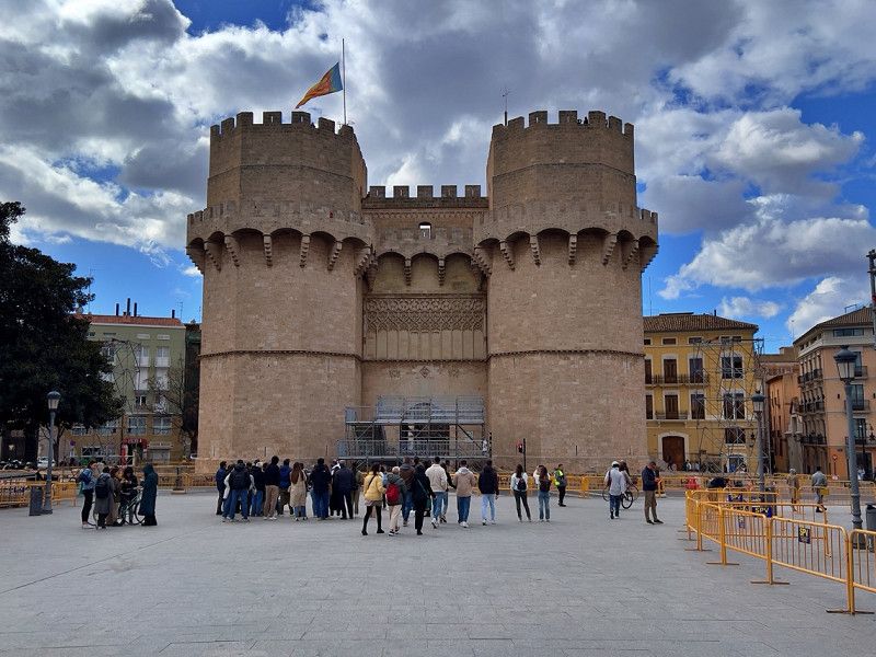
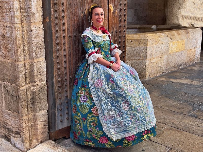
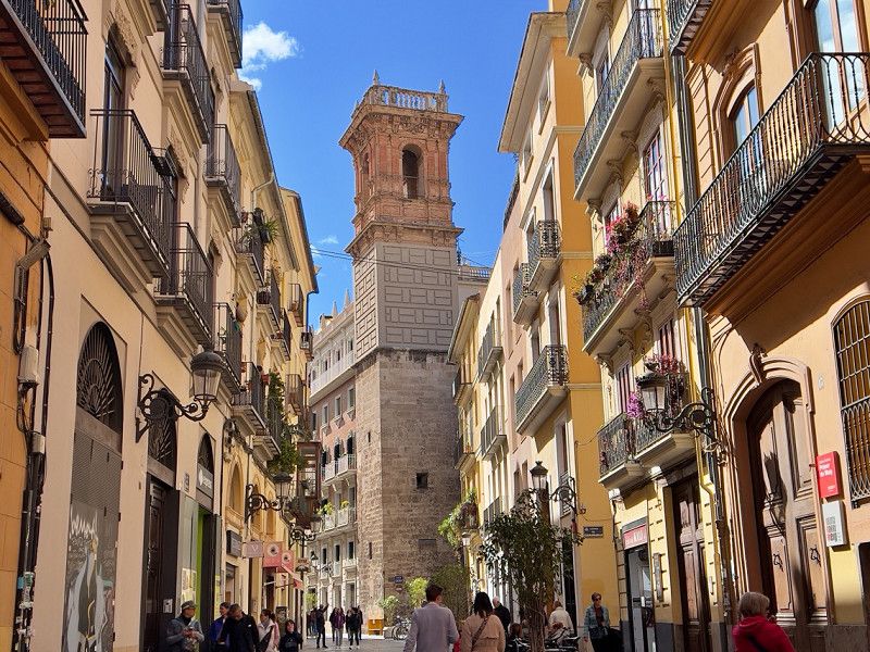
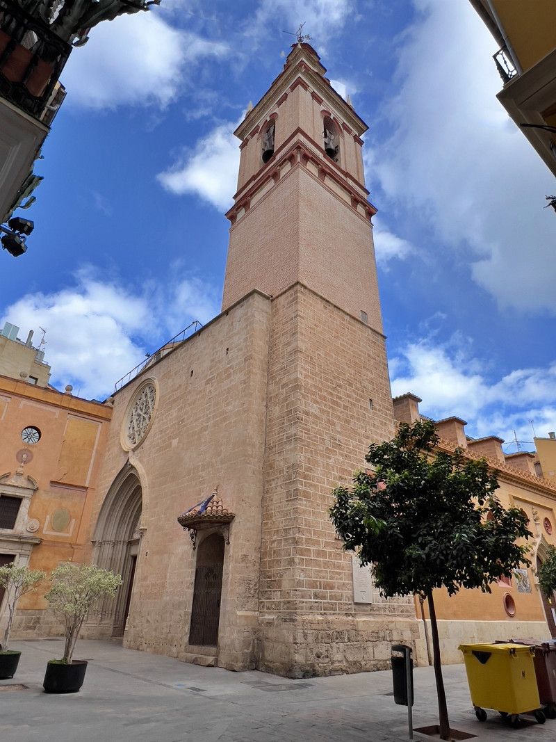
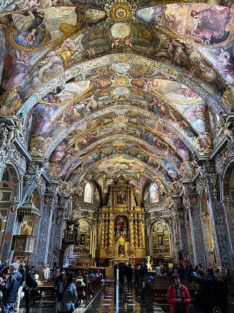
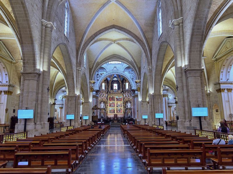
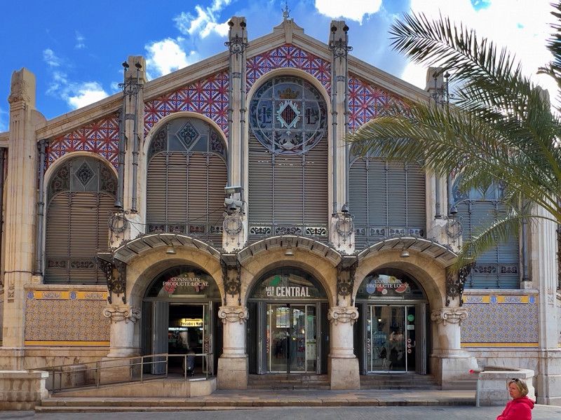
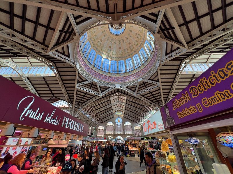
On the second day we passed the Science City through the former riverbed, now a park, and continued to the Torre, the mighty former city gate. We looked at the church of San Nicola, also known as the "Sistine Chapel of Valencia", strolled through the market hall "Mercat Central" and through the alleys to the cathedral. Valencia has so much to offer that we will definitely come back.
Valencia, Provinz Valencia, Spanien
39° 28' 11.7" N 0° 22' 34.6" W
39.4699075 -0.3762881
• Head toward Calle Pérez Pujol on Calle Correos. Go for 89 m.
• Turn right onto Calle Pérez Pujol. Go for 73 m.
• Turn left onto Calle Roger de Lauria. Go for 81 m.
• Turn right onto Calle Pascual y Genís. Go for 143 m.
• Continue on Calle Félix Pizcueta. Go for 272 m.
• Turn right onto Gran Vía Marqués del Turia. Go for 157 m.
• Continue on Gran Vía de las Germanías toward Aeropuerto/Madrid/A-3/CV-35/Llíria/V-31/Alacant/Albacete. Go for 243 m.
• Keep right onto Gran Vía de las Germanías toward Alacant/V-31/Albacete/València Joaquín Sorolla. Go for 164 m.
• Turn left onto Calle de Gibraltar. Go for 34 m.
• Turn slightly right onto Calle Cuba. Go for 253 m.
• Turn right onto Calle Puerto Rico. Go for 167 m.
• Turn right onto Calle Filipinas. Go for 82 m.
• Make a U-Turn onto Calle Filipinas. Go for 506 m.
• Continue on Plaza de Manuel Sanchis Guarner. Go for 69 m.
• Turn right onto Avenida de Ausiàs March. Go for 1.3 km.
• Take the 3rd exit from roundabout onto Avenida de Ausiàs March (V-31) toward V-30/Hospital La Fe/Hospital Urgències/Urgencias. Go for 13.8 km.
• Continue on A-7 (Autovía del Mediterráneo). Go for 42.8 km.
• Continue on A-35 toward Albacete/Murcia. Go for 32.8 km.
• Take exit 11 toward La Font de la Figuera/Alacant/Alicante/Murcia onto A-33. Go for 92.9 km.
• Continue on A-30 (Autovía de Murcia). Go for 22.5 km.
• Take exit 134A toward Murcia/Ronda Oeste/Cartagena/E-15/Almería/A-7 onto A-30 (Murcia Ronda Oeste). Go for 57.7 km.
• Continue on Calle Juan Muñoz Delgado. Go for 250 m.
• Continue on Paseo de Alfonso XIII. Go for 277 m.
• Take the 2nd exit from roundabout onto Paseo de Alfonso XIII toward Centro Ciudad/A-332/Mazarrón. Go for 1.2 km.
• Take the 1st exit from Plaza de España roundabout onto Alameda de San Antón. Go for 372 m.
• Turn left onto Calle Soldado Rosique. Go for 267 m.
• Continue on Avenida del Cantón. Go for 65 m.
• Turn right onto Avenida Francisco de Córdoba. Go for 234 m.
• Turn left toward Calle Francisco Córdoba Roch. Go for 90 m.
• Turn right onto Calle Francisco Córdoba Roch. Go for 88 m.
• Arrive at Calle Francisco Córdoba Roch. Your destination is on the left.
☍
268,9 km
(2 hrs. 29 min.)
Polígono de la Rambla de Benipila, 26
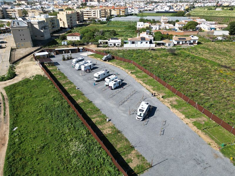
We are on our way to Roquetas de Mar in the Gulf of Almeria and are stopping here. The permitted parking space is actually at the football stadium, but there is a game today and the space is closed. So, like other campers, we have moved to the shopping center parking lot.
37° 36' 37.7" N 0° 59' 55.4" W
37.6104736 -0.9987345
• Head southeast on Calle Francisco Córdoba Roch. Go for 88 m.
• Turn left. Go for 90 m.
• Turn right toward Avenida Francisco de Córdoba. Go for 32 m.
• Continue on Avenida Francisco de Córdoba. Go for 202 m.
• Turn right onto Avenida del Cantón. Go for 1.2 km.
• Take the 2nd exit from roundabout onto Carretera de Tentegorra. Go for 241 m.
• Take the 1st exit from roundabout onto Pasaje Blases (N-332) toward Mazarrón. Go for 866 m.
• Take the 2nd exit from roundabout onto RM-332 toward Almería/Mazarrón. Go for 725 m.
• Take the 2nd exit from roundabout onto RM-332. Go for 798 m.
• Take the 2nd exit from roundabout toward E-15/AP-7/Mazarrón/Vera/Almería/Alicante. Go for 1.1 km.
• Take ramp onto AP-7 toward Mazarrón/Vera/Almería. Go for 97.4 km.
• Continue toward Autovía del Mediterráneo/A-7. Go for 502 m.
• Take the left exit toward Los Gallardos/Almería onto A-7 (Autovía del Mediterráneo). Go for 101 km.
• Take exit 800 toward Roquetas de Mar/Aguadulce/Vícar (Este). Go for 162 m.
• Take the 3rd exit from roundabout onto A-391 toward E-15/A-7/Almería/El Parador/A-1051/Roquetas de Mar/Aguadulce. Go for 241 m.
• Take the 1st exit from roundabout onto A-1051 toward El Parador/Roquetas de Mar. Go for 401 m.
• Take the 2nd exit from roundabout onto A-1051 (Variante de Roquetas de Mar) toward Roquetas de Mar/N-340a. Go for 9.0 km.
• Take the 3rd exit from roundabout onto Variante de Roquetas de Mar (A-1051). Go for 724 m.
• Take the 4th exit from roundabout onto Camino de la Solana. Go for 129 m.
• Turn right onto Camino de los Baños. Go for 1.2 km.
• Continue on Carretera Los Mercados. Go for 82 m.
• Turn left onto Calle Colombia. Go for 262 m.
• Continue on Carretera La Marina. Go for 163 m.
• Arrive at Carretera La Marina. Your destination is on the right.
☍
216,7 km
(1 hrs. 57 min.)
Diseminado la Lomilla, 25
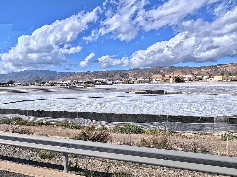
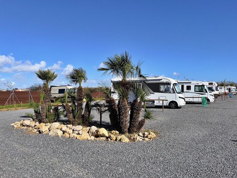
We have arrived at our next destination, the Camper Park Roquetas. We will stay here for a week and meet up with our friends. We have already made a first trip along the beach to do some shopping. The white tarpaulins of the fruit and vegetable plantations are noticeable everywhere in the Gulf of Almeria; in the sun they sometimes shimmer like the sea.
36° 44' 43.1" N 2° 37' 4.8" W
36.7453003 -2.6180010
• Head south on Carretera La Marina. Go for 60 m.
• Turn left toward Calle Martinica. Go for 73 m.
• Turn right onto Calle Martinica. Go for 34 m.
• Continue on Calle Brasília. Go for 42 m.
• Turn left onto Calle Guatemala. Go for 310 m.
• Turn left onto Avenida Sabinar (AL-4151). Go for 1.1 km.
• Take the 4th exit from roundabout onto Avenida Sabinar (AL-4151) toward Centro Ciudad. Go for 504 m.
• Take the 2nd exit from Avenida Roquetas de Mar roundabout onto Avenida Roquetas (AL-4151). Go for 808 m.
• Take the 1st exit from roundabout onto Paseo Los Baños. Go for 332 m.
• Take the 3rd exit from roundabout onto Paseo Los Baños. Go for 309 m.
• Take the 2nd exit from roundabout onto Paseo Los Baños. Go for 220 m.
• Arrive at Paseo Los Baños. Your destination is on the left.
☍
3,8 km
( 9 min.)
Roquetas de Mar
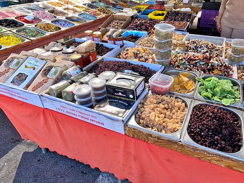
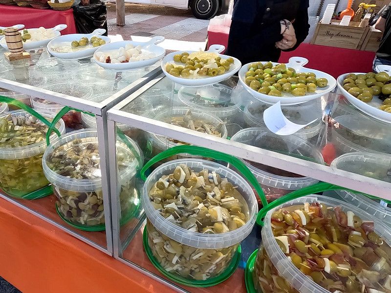
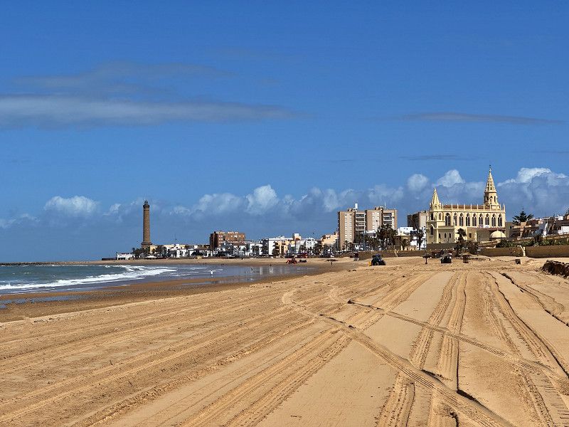
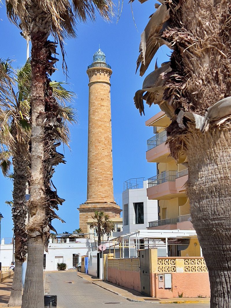
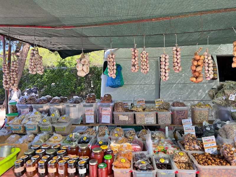
We set off on our bikes to the town of Roquetas de Mar (the parking space is on the outskirts of town). There is a market on Thursdays. And we have to admit - we had never visited such a big market before. There were tons of stalls lined up next to each other. And there was pretty much everything. From clothes to household items to fruit, vegetables and pickled delicacies. And churros 😋
Tip: If you drive along the beach to the market, you will come to the snack bar "Aleman"; there is a large bicycle parking area there.
Paseo Los Baños, Roquetas de Mar, Andalusien, Spanien
36° 46' 1.4" N 2° 36' 17.4" W
36.7670686 -2.6048446
• Head toward Calle Olimpiadas on Paseo Los Baños. Go for 197 m.
• Take the 2nd exit from roundabout onto Paseo Los Baños. Go for 169 m.
• Turn right onto Calle Víctor Palomo. Go for 88 m.
• Turn left onto Avenida Rey Juan Carlos I. Go for 120 m.
• Turn right onto Calle Reina Sofía. Go for 220 m.
• Take the 2nd exit from roundabout onto Avenida Curro Romero. Go for 197 m.
• Take the 2nd exit from roundabout onto Avenida Curro Romero toward Cortijos de Marín/La Mojonera. Go for 408 m.
• Continue on Camino El Cañuelo (A-1050). Go for 116 m.
• Take the 2nd exit from roundabout onto Camino El Cañuelo (A-1050). Go for 270 m.
• Turn right onto AL-9029. Go for 926 m.
• Take the 3rd exit from roundabout onto AL-9029. Go for 604 m.
• Take the 3rd exit from roundabout onto AL-9029 toward Carretera de las Losas/Vícar (Oeste)/Roquetas de Mar (Sur). Go for 187 m.
• Take the 2nd exit from roundabout onto Carretera Yegua Verde (AL-9029) toward Vícar (Oeste). Go for 1.3 km.
• Pass 2 roundabouts and continue on Carretera Zamora Cuatro (AL-9029). Go for 1.7 km.
• Take the 4th exit from roundabout onto N-340a. Go for 2.5 km.
• Take the 2nd exit from roundabout onto El Cosario (N-340a) toward E-15/N-340/Almería/Motril/Málaga. Go for 207 m.
• Continue on N-340a. Go for 210 m.
• Take the 2nd exit from roundabout toward E-15/A-7/Motril/Málaga. Go for 143 m.
• Continue toward Motril/Málaga. Go for 30 m.
• Take the 3rd exit from roundabout onto A-7 (Autovía del Mediterráneo) toward Motril/Málaga. Go for 17.0 km.
• Take exit 826 toward Balerma. Go for 275 m.
• Turn left onto AL-4302. Go for 248 m.
• Continue on AL-4300. Go for 2.8 km.
• Take the 2nd exit from roundabout onto AL-4300 toward Balerma. Go for 997 m.
• Continue on Avenida Príncipe Felipe (AL-4300). Go for 328 m.
• Take the 2nd exit from roundabout onto Calle Las Dalias (AL-4300). Go for 140 m.
• Continue on Plaza Puerta del Sol (AL-4300). Go for 43 m.
• Continue on Calle La Loma (AL-4300). Go for 265 m.
• Take the 2nd exit from roundabout onto Calle La Loma (AL-4300). Go for 176 m.
• Continue on Carretera de Balerma (AL-4300). Go for 608 m.
• Continue on AL-4300. Go for 1.3 km.
• Continue on Carretera a Balerma (AL-4300). Go for 279 m.
• Take the 1st exit from roundabout onto Carretera de Málaga (N-340a) toward E-15/A-7/Almería/Málaga. Go for 380 m.
• Continue on N-340a. Go for 631 m.
• Take the 3rd exit from roundabout onto A-7 (Autovía del Mediterráneo) toward Motril/Málaga. Go for 60.8 km.
• Take exit 889 toward Motril/GR-16/Torrenueva/N-340. Go for 410 m.
• Take the 2nd exit from roundabout onto GR-16 (Autovía Acceso Este al Puerto de Motril) toward Motril/N-340/Torrenueva. Go for 3.3 km.
• Take the 1st exit from roundabout toward Puerto de Motril. Go for 280 m.
• Take the 2nd exit from roundabout toward Acceso Este Puerto de Motril/puerto de Motril. Go for 330 m.
• Take the 2nd exit from roundabout. Go for 163 m.
• Continue on Calle Muelle Pesquero. Go for 213 m.
• Continue on Paseo del Puerto. Go for 935 m.
• Take the 2nd exit from roundabout onto Carretera de la Celulosa (N-323a). Go for 352 m.
• Turn left toward Calle Zinnia. Go for 11 m.
• Continue on Calle Zinnia. Go for 129 m.
• Turn right onto Camino del Pelaillo. Go for 1.2 km.
• Arrive at Camino del Pelaillo. Your destination is on the right.
☍
103,2 km
(1 hrs. 19 min.)
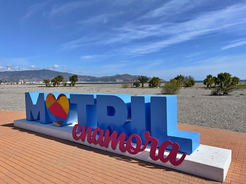
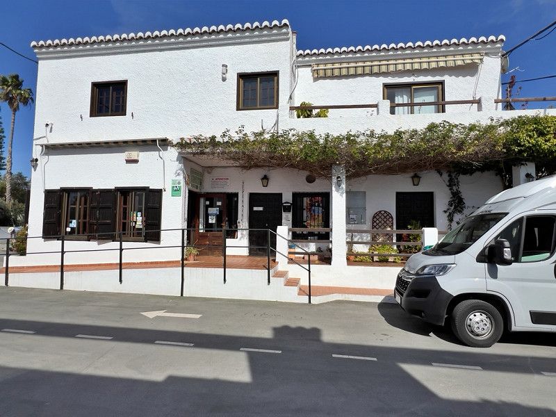
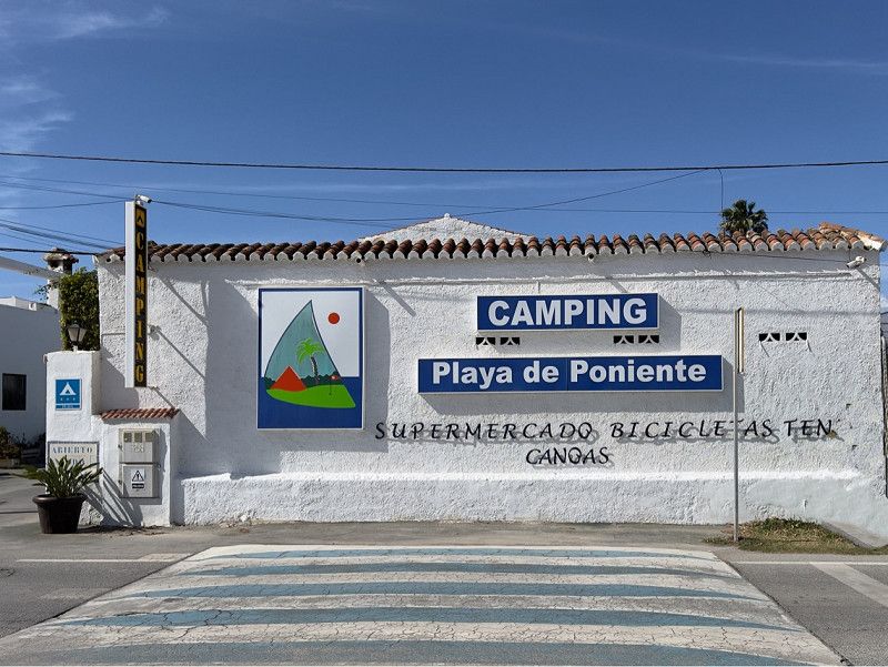
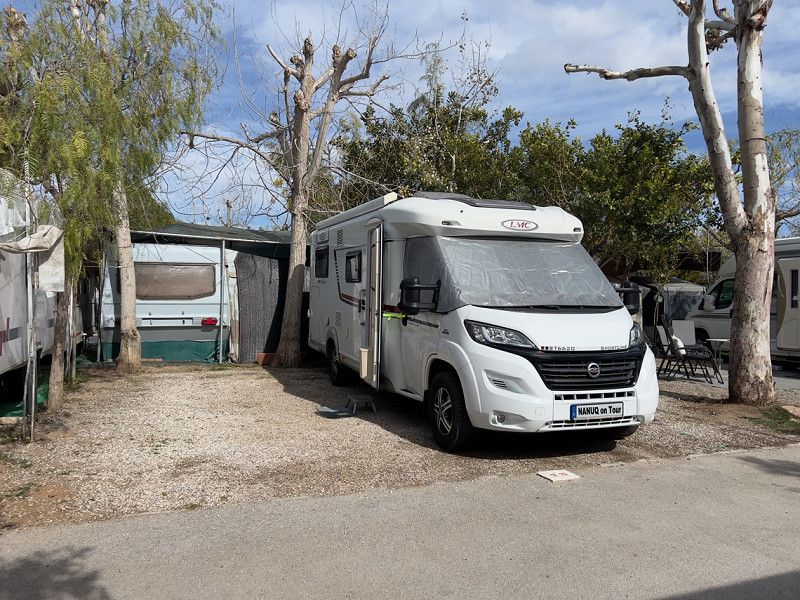
Camping Playa de Poniente
We continued on towards Malaga, but only about halfway there. We stopped at a campsite in Motril, which is close to the beach, to plan our next destinations and edit all the pictures. We actually wanted to go to the Alhambra from here, but the whole of March is "fully booked", whereas the whole of April is still available. It seems sensible to reserve the tickets very early. Then we'll have to do it on our next visit.
36° 43' 5.9" N 3° 32' 49.2" W
36.7183076 -3.5470016
• Head northeast on Camino del Pelaillo. Go for 1.1 km.
• Turn left onto Calle Moral. Go for 184 m.
• Turn left onto Carretera de la Celulosa (N-323a). Go for 3.2 km.
• Take the 2nd exit from roundabout onto Autovía Acceso Oeste al Puerto de Motril (GR-14) toward Granada/A-44/Jaén/E-15/A-7/Málaga. Go for 555 m.
• Take the 2nd exit from roundabout onto GR-14 (Autovía Acceso Oeste al Puerto de Motril) toward Granada/A-44/Jaén. Go for 2.5 km.
• Take the 2nd exit from roundabout onto A-7 (Autovía del Mediterráneo) toward A-44/Granada/Jaén. Go for 616 m.
• Take the exit onto A-7 (Autovía del Mediterráneo). Go for 3.7 km.
• Take exit 896 toward Vélez de Benaudalla/Granada/Jaén onto A-44 (Autovía de Sierra Nevada). Go for 41.7 km.
• Take the exit toward A-92G/Aeropuerto/Sevilla/N-432/Córdoba/Jaén/A-4/Madrid onto A-44 (Circunvalación Exterior de Granada). Go for 21.0 km.
• Take exit 120 toward Granada/Almería/Murcia/Jaén onto A-92. Go for 55.6 km.
• Take exit 294 toward Guadix onto A-325. Go for 1.5 km.
• Continue on Carretera de Benalúa. Go for 153 m.
• Turn right onto Avenida Buenos Aires. Go for 359 m.
• Turn left onto Avenida Buenos Aires. Go for 7 m.
• Continue on Calle Adolfo Suárez. Go for 46 m.
• Turn right onto Calle Adolfo Suárez. Go for 60 m.
• Arrive at Calle Adolfo Suárez. Your destination is on the left.
☍
132,3 km
(1 hrs. 16 min.)
Área Autocaravanas Guadix
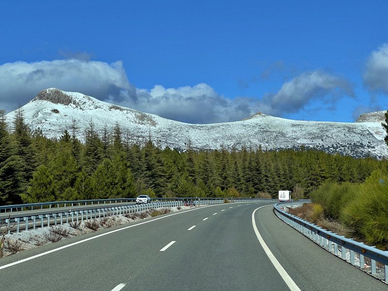
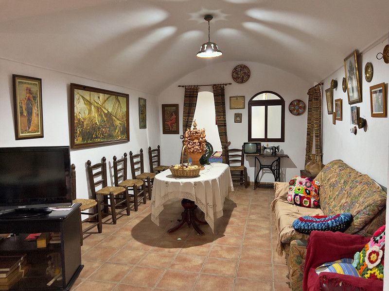
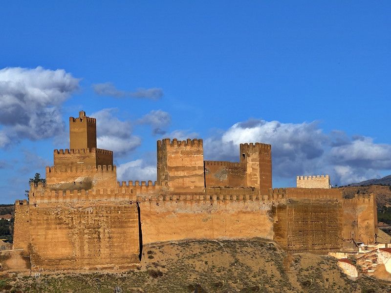
We drove past the snow-covered mountains of the Sierra Nevada to Guadix. The town is known for the almost 2,000 cave dwellings in which people lived during the Moorish era in the 12th century. The cave museum and a house can be visited. There is also the Moorish fortress from that time (currently being renovated) and the cathedral.
Av. Buenos Aires, 18500, Guadix, Spanien
37° 18' 13" N 3° 8' 1" W
37.3036100 -3.1336100
• Head southwest on Calle Adolfo Suárez. Go for 47 m.
• Turn right onto Calle Adolfo Suárez. Go for 52 m.
• Turn right onto Avenida Buenos Aires. Go for 469 m.
• Turn left onto Carretera de Benalúa. Go for 153 m.
• Continue on A-325. Go for 1.5 km.
• Take left ramp onto A-92 toward Granada. Go for 134 km.
• Take exit 160 toward Antequera/Hospital. Go for 503 m.
• Turn left onto A-7282 toward Antequera/Málaga/Algeciras. Go for 291 m.
• Pass 4 roundabouts and continue on Carretera de Málaga (A-7282). Go for 9.1 km.
• Take the 4th exit from roundabout onto Carretera de Málaga (A-7282). Go for 337 m.
• Take the 3rd exit from roundabout onto Carretera de Málaga (A-7282). Go for 920 m.
• Pass 2 roundabouts and continue on Carretera de Málaga. Go for 1.0 km.
• Turn right onto Camino Terrizo. Go for 35 m.
• Arrive at Camino Terrizo. Your destination is on the right.
☍
148,1 km
(1 hrs. 24 min.)
Antequera
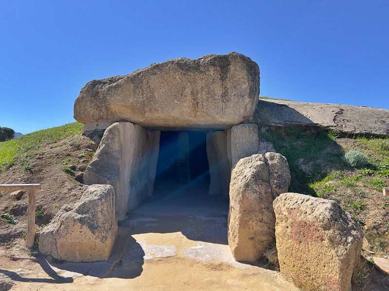
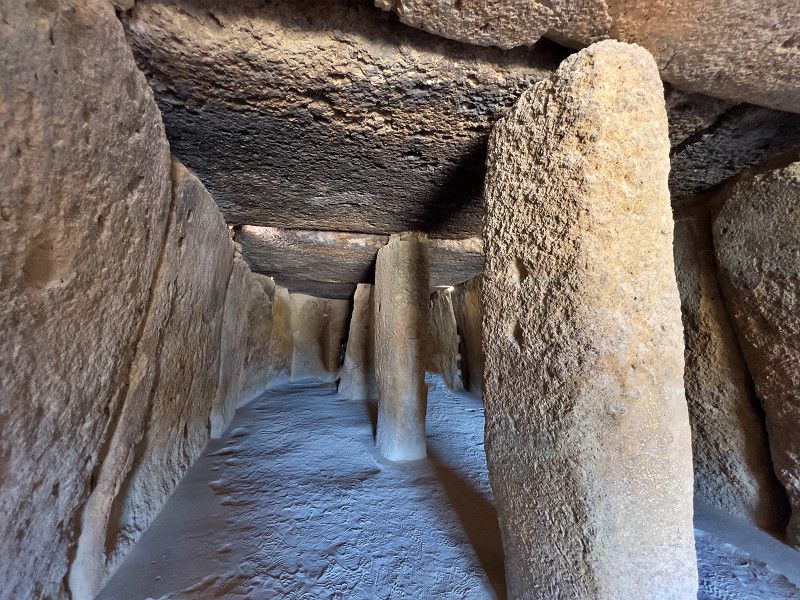
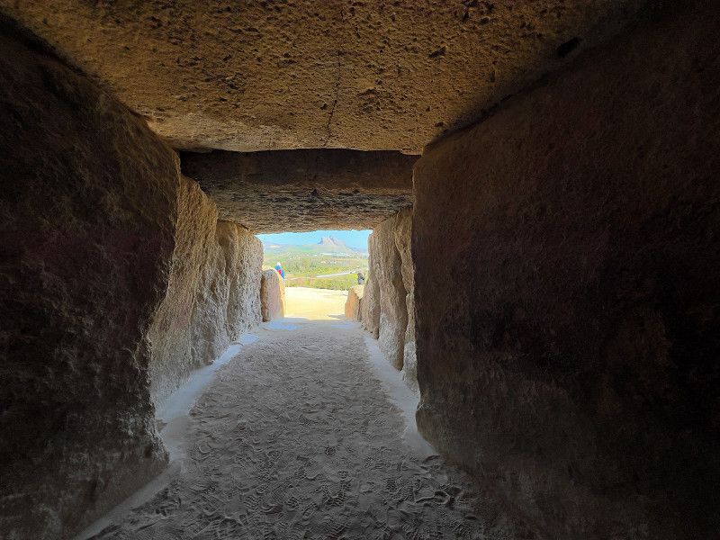
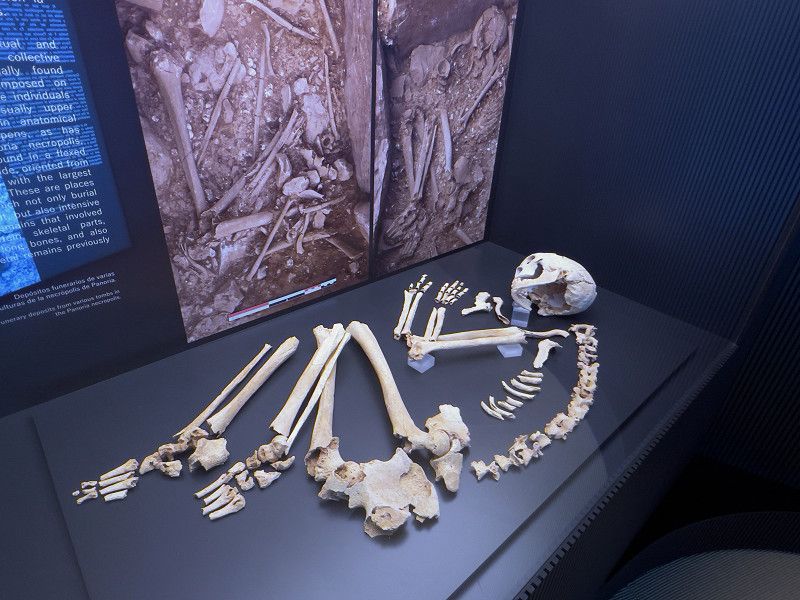
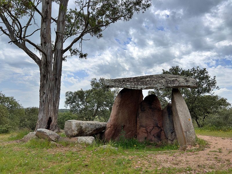
On our way to the west coast of Spain we make several detours. Today we visited the burial mounds (dolmens) of Antequera. We already know these dolmens, which date from around 4,000 to 3,000 BC and were used as burial sites, from Sylt, Ireland and France. We find it fascinating what motivated people back then and how they managed to build a ring-shaped building out of stones weighing tons and cover it with stones weighing up to 180 tons. There is a small exhibition in the visitor center. Visiting the complex is free, by the way.
A-354, Antequera, Antequera, Andalusien, Spanien
37° 1' 27.6" N 4° 32' 49.2" W
37.0243401 -4.5470056
• Head toward Carretera de Málaga on Camino Terrizo. Go for 35 m.
• Turn right onto Carretera de Málaga. Go for 326 m.
• Continue on Camino Cementerio. Go for 41 m.
• Continue on Calle Córdoba. Go for 168 m.
• Continue on Calle Archidona toward Centro Ciudad. Go for 185 m.
• Continue on Plaza Santiago. Go for 48 m.
• Continue on Calle Carrera. Go for 350 m.
• Continue on Plaza de las Descalzas. Go for 57 m.
• Turn left onto Plaza de las Descalzas. Go for 41 m.
• Turn right onto Cuesta de Barbacanas. Go for 46 m.
• Turn right onto Calle de Nájera. Go for 175 m.
• Turn left onto Calle Zapateros. Go for 21 m.
• Turn right onto Cuesta Viento. Go for 104 m.
• Continue on Calle Caldereros. Go for 124 m.
• Continue on Plaza del Portechuelo. Go for 360 m.
• Continue on Barrio Enchidero. Go for 291 m.
• Turn left onto Carretera a Villanueva de la Concepción (A-343). Go for 565 m.
• Continue on A-7075 toward Villanueva de la Concepción/Almogía/Málaga. Go for 9.9 km.
• Turn right toward El Torcal. Go for 3.5 km.
• Arrive at your destination on the right.
☍
16,3 km
( 24 min.)
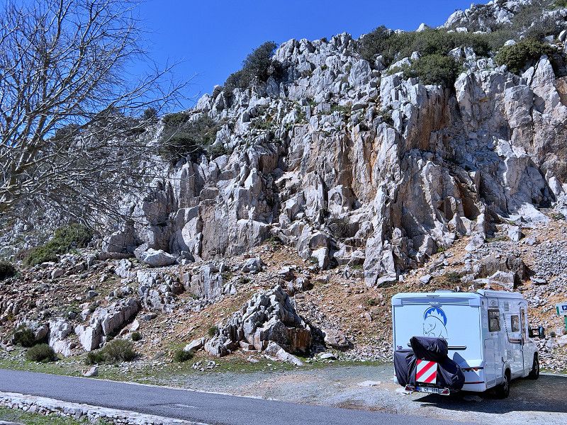
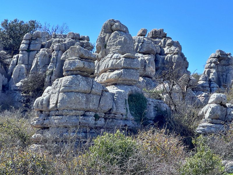
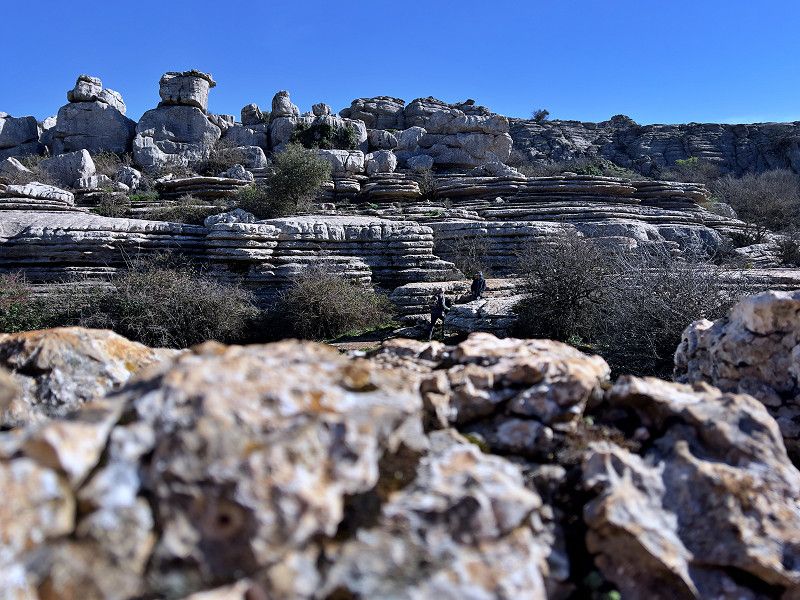
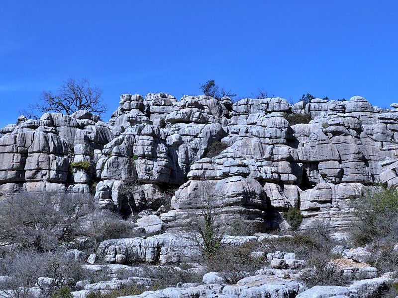
Antequera-El Torcal
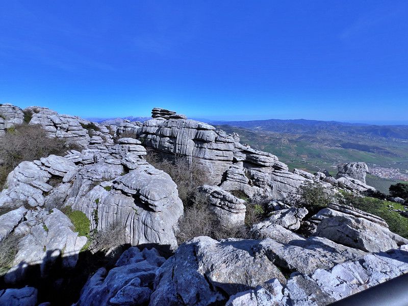
200 million years ago, the area around Antequera was a primeval sea. The limestone deposits of marine animals and corals formed a karst mountain range, which over time created a unique erosion mountain range with bizarre rocks. We hiked through this impressive rocky landscape on the one-hour "small" tour.
MA-9016, Antequera, Antequera, Andalusien, Spanien
36° 57' 11.1" N 4° 32' 40.2" W
36.9530757 -4.5445035
• Head north. Go for 2.1 km.
• Continue toward A-7075. Go for 1.4 km.
• Turn left onto A-7075. Go for 9.9 km.
• Continue on A-343 toward Antequera. Go for 852 m.
• Turn right onto Calle Santa María la Vieja. Go for 77 m.
• Arrive at Calle Santa María la Vieja. Your destination is on the right.
☍
14,3 km
( 17 min.)
Antequera
We end the day at the free parking space in Antequera.
A-343, Antequera, Antequera, Andalusien, Spanien
37° 0' 40.2" N 4° 33' 43.1" W
37.0111782 -4.5619769
• Head toward Carretera a Villanueva de la Concepción on Calle Santa María la Vieja. Go for 77 m.
• Turn left onto Carretera a Villanueva de la Concepción (A-343). Go for 852 m.
• Turn right onto A-343 toward Lobo Park/Valle de Abdalajís/Álora. Go for 18.1 km.
• Turn right onto MA-226. Go for 229 m.
• Continue on Calle Viento (MA-226). Go for 178 m.
• Continue on Calle Calvario (MA-226). Go for 62 m.
• Continue on Calle Alta (MA-226). Go for 12 m.
• Turn slightly right onto Calle Alta (MA-226). Go for 75 m.
• Keep right onto Calle Alta (MA-226). Go for 45 m.
• Continue on Calle Agua (MA-4401). Go for 182 m.
• Continue on MA-4401. Go for 3.7 km.
• Continue on MA-4401. Go for 832 m.
• Continue on Las Angosturas (MA-4401). Go for 73 m.
• Turn left onto MA-4401. Go for 369 m.
• Turn right onto MA-4401. Go for 1.2 km.
• Turn left onto MA-4401. Go for 2.9 km.
• Continue on MA-5403. Go for 222 m.
• Turn slightly left onto MA-5403. Go for 11 m.
• Turn slightly right onto Calle Estación Chorro. Go for 297 m.
• Turn slightly right. Go for 1.1 km.
• Arrive at your destination.
☍
30,6 km
( 43 min.)
Ardales
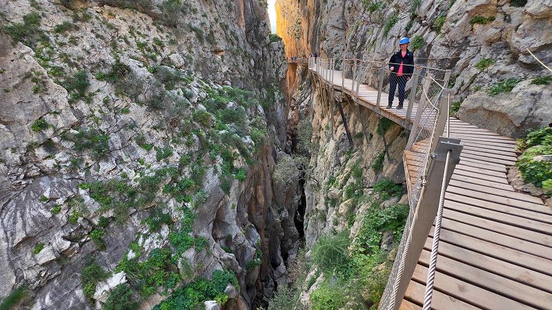
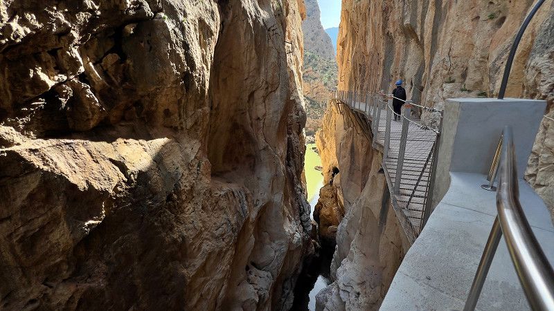
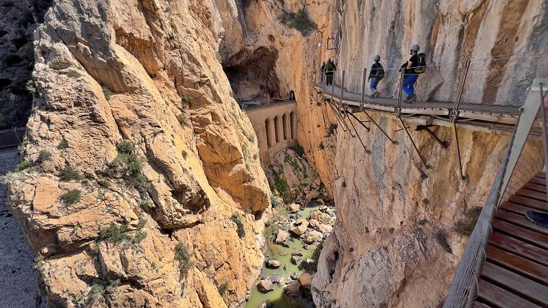
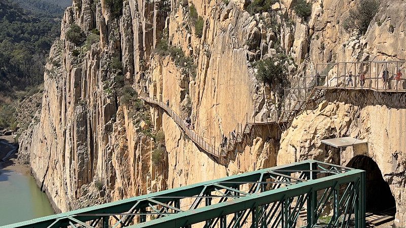
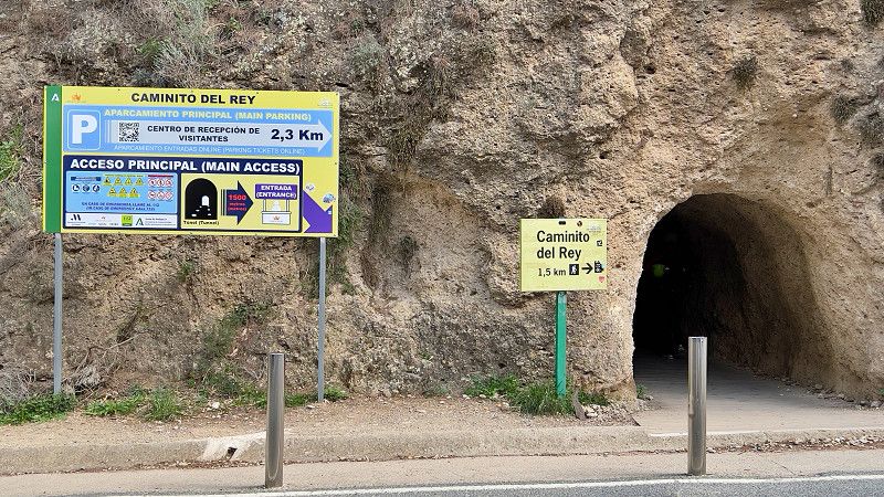
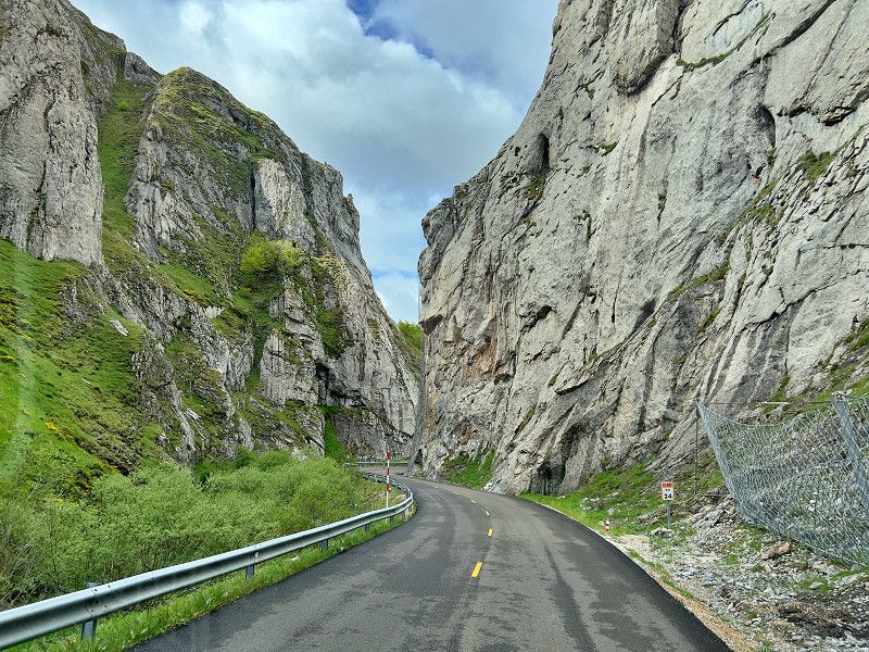
We are spending two days in Ardales at the Parque Ardales campsite. And for one reason only: we want to go on the Caminito del Rey. The path, which hangs on the walls of the gorge at a height of around 100 metres, was built between the Gaitanejo and El Chorro waterfalls to transport materials and for maintenance work on the hydroelectric power station. Until it was completely renovated in 2015, it was considered one of the most dangerous paths in the world. In 1921, King Alfonso XIII inaugurated this great structure by crossing the path to the Conde de Guadalhorce dam. Since then, the route has been called the "Caminito del Rey" (King's Path). The return trip costs €2.50 per person by shuttle bus. If you are at the campsite, you should get off at the 3rd station (Mirador).
Caminito del Rey, Ardales, Guadalteba, Andalusien, Spanien
36° 54' 59" N 4° 46' 24.8" W
36.9163928 -4.7735596
• Head southeast. Go for 1.1 km.
• Turn slightly left onto Calle Estación Chorro. Go for 297 m.
• Turn slightly right onto MA-5403. Go for 504 m.
• Continue on Carretera El Chorro (MA-5403). Go for 51 m.
• Turn right onto Carretera El Chorro (MA-5403). Go for 207 m.
• Continue on MA-5403. Go for 5.8 km.
• Take the 3rd exit from roundabout onto MA-5403. Go for 5.5 km.
• Turn right onto MA-5403. Go for 101 m.
• Continue on A-357. Go for 6.7 km.
• Take ramp toward Teba/A-367/Ronda/A-7278. Go for 265 m.
• Take the 2nd exit from roundabout toward Teba/A-7278/Ronda/A-367. Go for 111 m.
• Take the 1st exit from roundabout onto A-367 toward Teba/A-7278/Ronda. Go for 40.6 km.
• Continue toward Avenida de Málaga. Go for 51 m.
• Take the 2nd exit from roundabout onto Avenida de Málaga toward Ronda/San Pedro de Alcántara/Algeciras. Go for 242 m.
• Pass 3 roundabouts and continue on Avenida de Málaga. Go for 921 m.
• Take the 3rd exit from Avenida de Málaga roundabout onto Calle Calerín. Go for 137 m.
• Arrive at Calle Calerín.
☍
62,7 km
(1 hrs. 11 min.)
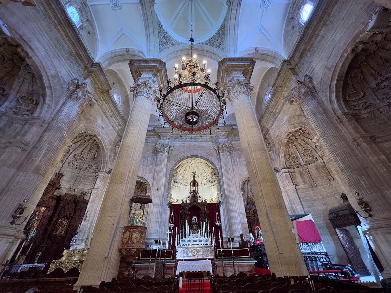
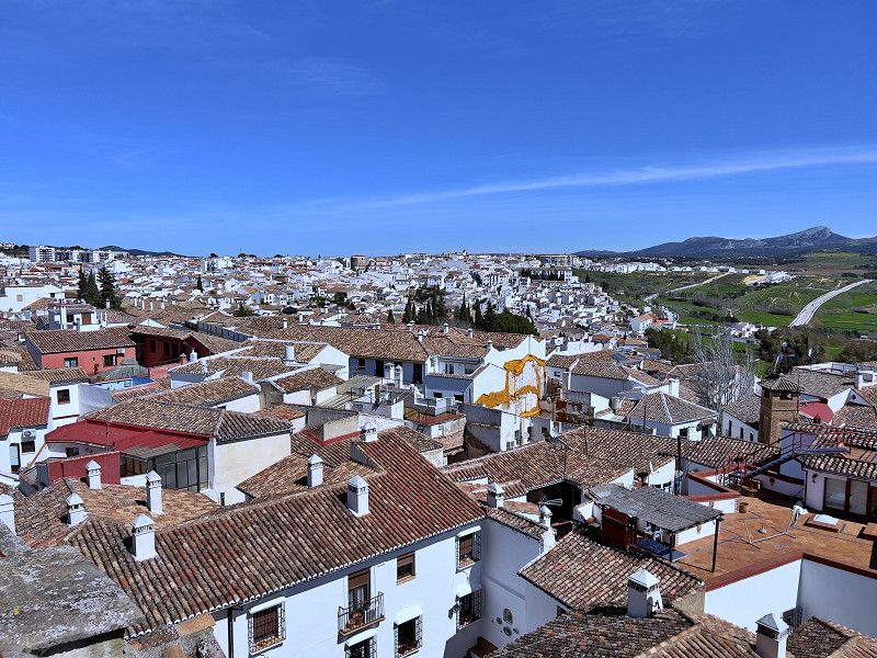
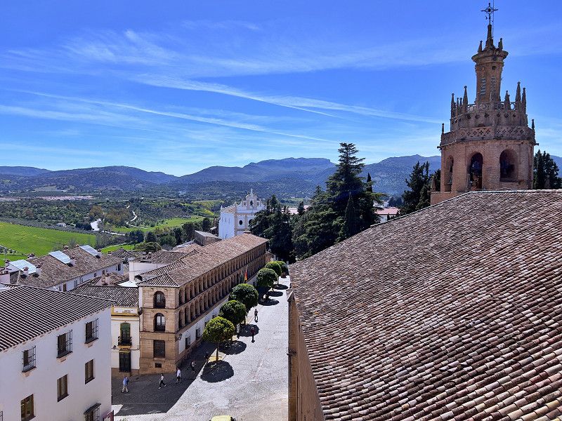
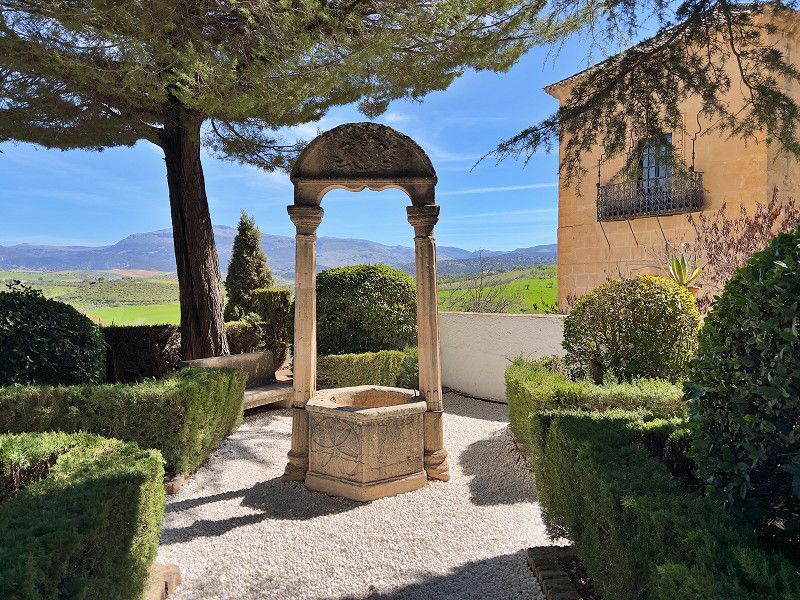
Ronda
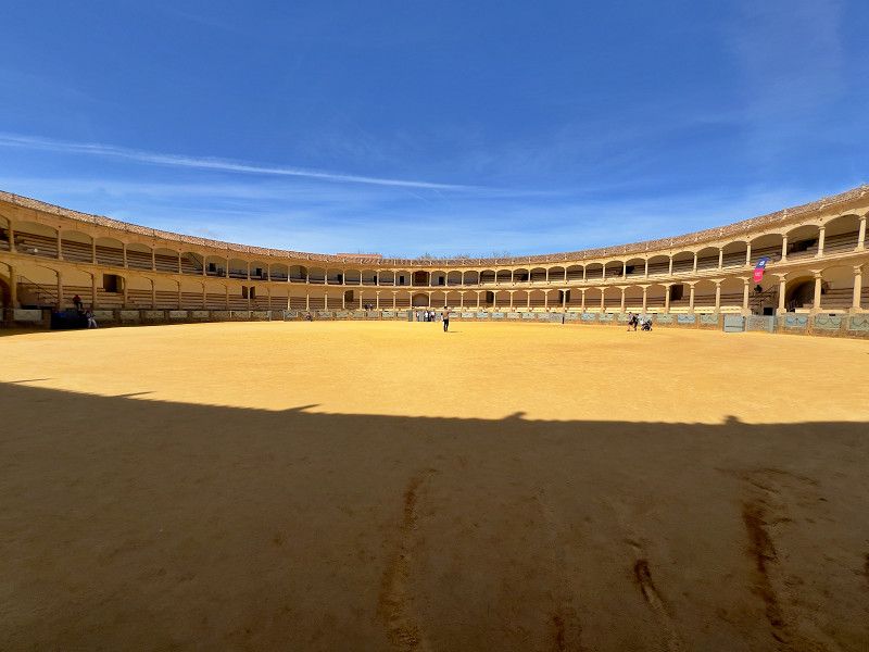
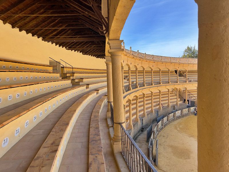
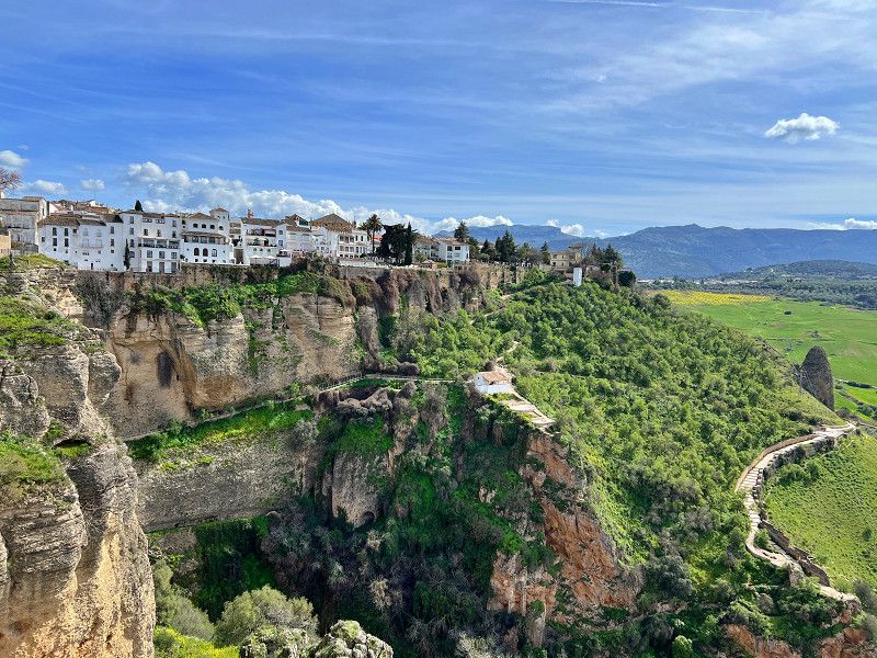
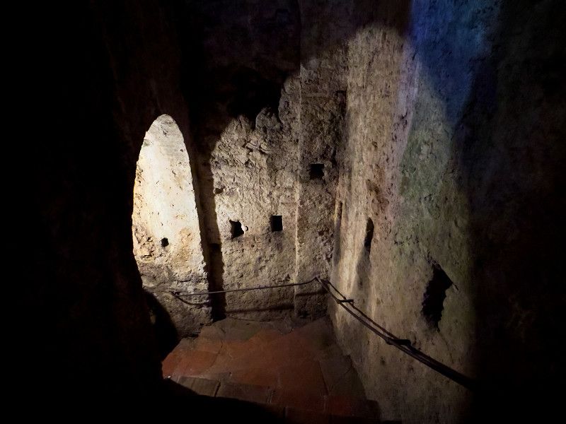
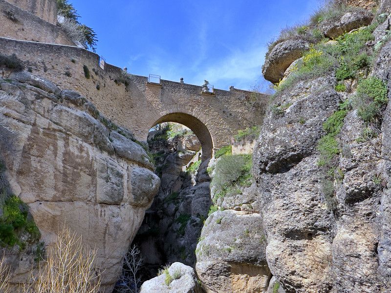
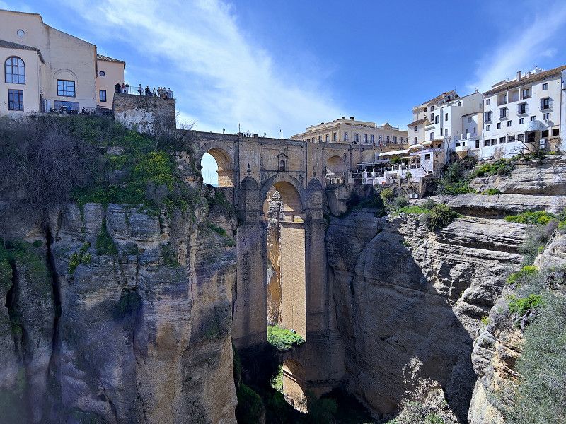
We stop in Ronda, the largest town among the "white villages". From the parking space, it is easy to walk to the pedestrian zone in no more than 30 minutes. Even if we are not fans of Spanish bullfighting, the largest arena in Spain is one of Ronda's main attractions. The audio guide tells us a lot about the history and architecture of the arena. We go to Ronda's old town via what is probably the most photographed motif of all, the "New Bridge". We walk through the old town streets to the cathedral. From the gallery, we enjoy the view of Ronda and the surrounding landscape. And then there is the castle, which already existed in the Moorish era (which you can see once you have paid the entrance fee of €10 per person) and which you can no longer visit yourself for good reason. But you can visit the gardens and the cave; a natural crevice in the rock that the Moors built down to the river. 60 meters or 20 floors down and back up again. After a break in the tapas bar, we walk over the "Old Bridge" into the New Town; the best view of the "New Bridge" is from the park.
Calle Calerín, Ronda, Serranía de Ronda, Andalusien, Spanien
36° 44' 48.7" N 5° 9' 22.3" W
36.7468747 -5.1561859
• Head toward Calle Virgen Inmaculada on Calle Calerín. Go for 98 m.
• Take the 1st exit from Avenida de Málaga roundabout onto Avenida de Málaga. Go for 161 m.
• Pass 3 roundabouts and continue on Avenida de Málaga. Go for 862 m.
• Take the 4th exit from roundabout onto Carretera de Circunvalación (A-374) toward Sevilla. Go for 34.3 km.
• Keep left onto A-384 toward Villamartín/Jerez de la Frontera/A-375/Pto. Serrano/Sevilla. Go for 47.3 km.
• Continue on A-382. Go for 27.2 km.
• Continue on A-2005. Go for 365 m.
• Turn right onto CA-3105 toward N-4/Aeropuerto. Go for 299 m.
• Take the 3rd exit from roundabout onto N-349 toward Aeropuerto/A-4/Cádiz/Sevilla/El Pto. de Sta. María/Sanlúcar/Chipiona/Rota. Go for 3.3 km.
• Take the 3rd exit from roundabout onto A-4 (Autovía del Sur) toward Jerez de la Frontera/El Pto. de Sta. María/Sanlúcar/Chipiona/Rota. Go for 19.0 km.
• Take exit 649 toward El Puerto de Sta. María/Pobl. Doña Blanca/Rota/Chipiona/A-2001/Sanlúcar/Puerto Sta. María. Go for 285 m.
• Take the 1st exit from roundabout onto A-491 toward Rota/Chipiona/A-2001/Sanlúcar. Go for 552 m.
• Take the 2nd exit from roundabout onto A-491 toward Rota/Chipiona/Sanlúcar/A-2001/Puerto de Santa María. Go for 4.8 km.
• Take exit 24 toward El Puerto de Sta. María/Centro Ciudad/Puerto de Sta. María. Go for 264 m.
• Take the 3rd exit from roundabout onto Calle Prolongación Avenida del Cisne toward Puerto de Sta. María. Go for 558 m.
• Take the 2nd exit from roundabout onto Calle Prolongación Avenida del Cisne. Go for 436 m.
• Take the 2nd exit from roundabout onto Avenida del Cisne. Go for 361 m.
• Take the 3rd exit from roundabout onto Avenida Padre Las Casas. Go for 317 m.
• Take the 3rd exit from roundabout onto Avenida Descubrimiento. Go for 629 m.
• Take the 1st exit from roundabout onto Calle Camino de los Enamorados. Go for 318 m.
• Turn left onto Calle Navazos. Go for 206 m.
• Arrive at Calle Navazos. Your destination is on the right.
☍
141,6 km
(1 hrs. 43 min.)
Camping Playa Las Dunas
We reserved a week here at the campsite to see the area and do various things. Since we are in our motorhome, we rented a car for 2 days through the campsite because we want to go to the white villages.
Paseo Maritimo Playa la Plantilla s/n, 11500, El Puerto de Santa María, Spain
36° 35' 18" N 6° 14' 25" W
36.5883300 -6.2402700
• Head toward Calle Camino de los Enamorados on Calle Navazos. Go for 18 m.
• Turn left toward Calle Villa de Altea. Go for 40 m.
• Turn left onto Calle Villa de Altea. Go for 248 m.
• Turn right onto Calle Camino de los Enamorados. Go for 265 m.
• Take the 2nd exit from roundabout onto Calle Camino de los Enamorados. Go for 463 m.
• Take the 2nd exit from Plaza de la Noria roundabout onto Avenida Constitución. Go for 642 m.
• Turn right onto Calle Aurora. Go for 34 m.
• Turn left onto Calle Bitácora. Go for 66 m.
• Turn left onto Avenida Bajamar. Go for 632 m.
• Turn left onto Calle Compositor Javier Caballero toward Centro Ciudad. Go for 50 m.
• Turn right onto Avenida Micaela Aramburu de Mora. Go for 201 m.
• Continue on Parque Calderón. Go for 360 m.
• Continue on Calle Ribera del Río. Go for 161 m.
• Continue on Calle Pozos Dulces. Go for 64 m.
• Turn right toward Avenida de Europa. Go for 41 m.
• Take the 1st exit from roundabout onto Avenida de Europa. Go for 894 m.
• Take the 3rd exit from roundabout onto Avenida de Valdelagrana. Go for 1.3 km.
• Take the 2nd exit from roundabout onto Avenida de Valdelagrana. Go for 1.1 km.
• Continue on CA-32. Go for 1.5 km.
• Take the exit toward Puerto Real/CA-35/Cadiz/E-5/Sevilla/AP-4 onto CA-32/CA-37. Go for 2.8 km.
• Take the exit toward Cádiz onto CA-35. Go for 8.1 km.
• Continue on Avenida Cortes de Cádiz. Go for 645 m.
• Take the 1st exit from Glorieta de Jesús Gargallo roundabout onto Avenida Astilleros. Go for 1.1 km.
• Turn right onto Avenida del Puerto. Go for 90 m.
• Turn sharp left onto Carretera Cuesta de las Calesas. Go for 343 m.
• Continue on Calle Santa Elena. Go for 107 m.
• Turn right onto Calle Murallas de San Roque. Go for 94 m.
• Take the 1st exit from roundabout onto Calle Murallas de San Roque. Go for 23 m.
• Continue on Calle Concepción Arenal. Go for 193 m.
• Continue on Avenida Campo del Sur. Go for 832 m.
• Turn right onto Calle Sagasta. Go for 480 m.
• Turn right onto Calle Sacramento. Go for 124 m.
• Turn right onto Calle José de Dios. Go for 64 m.
• Arrive at Calle José de Dios. Your destination is on the left.
☍
23,0 km
( 33 min.)
Cádiz
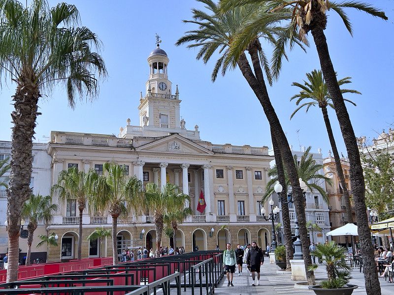
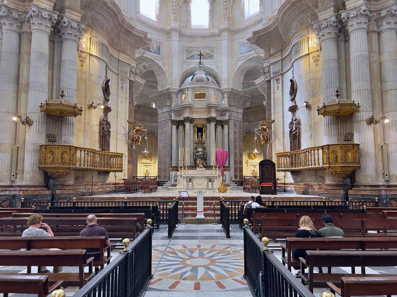
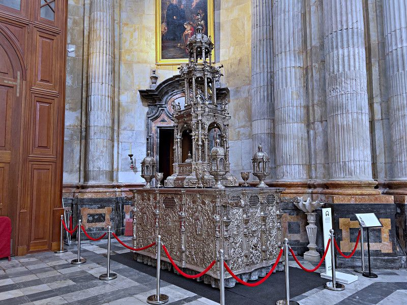
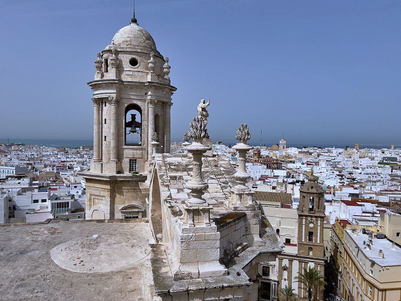
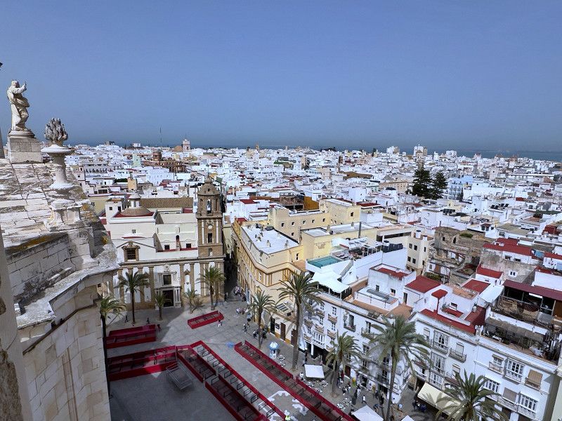
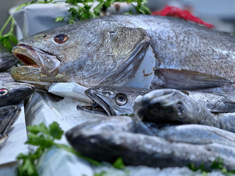
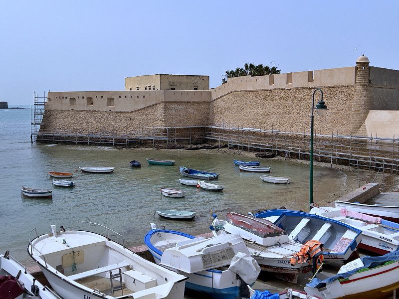
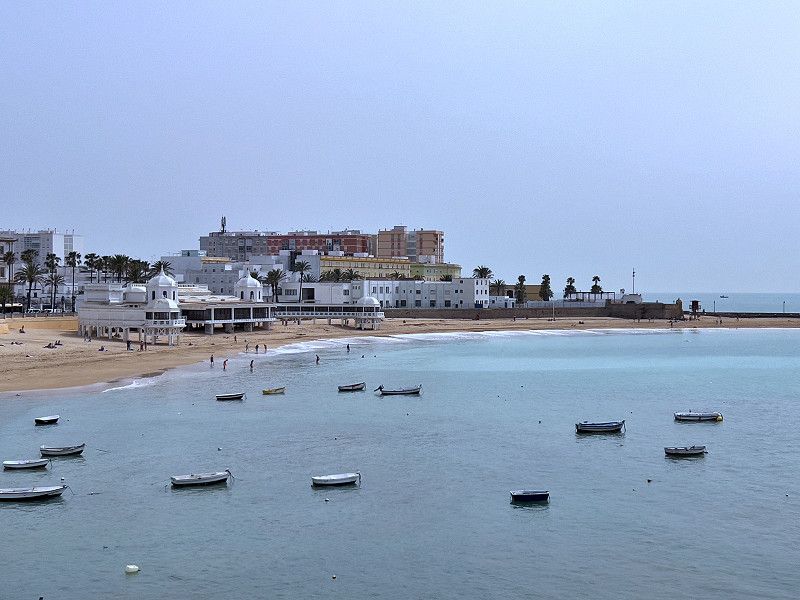
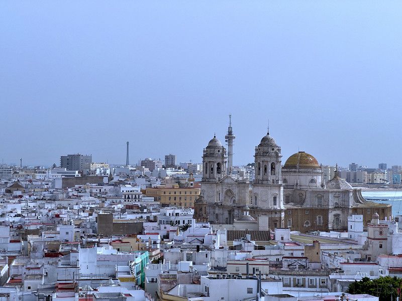
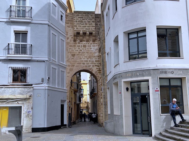
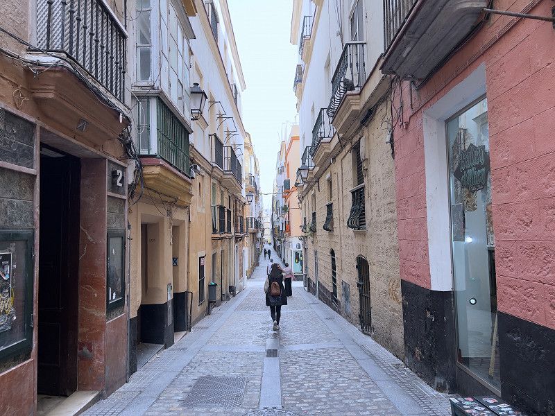
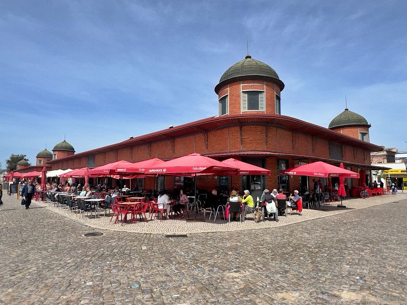
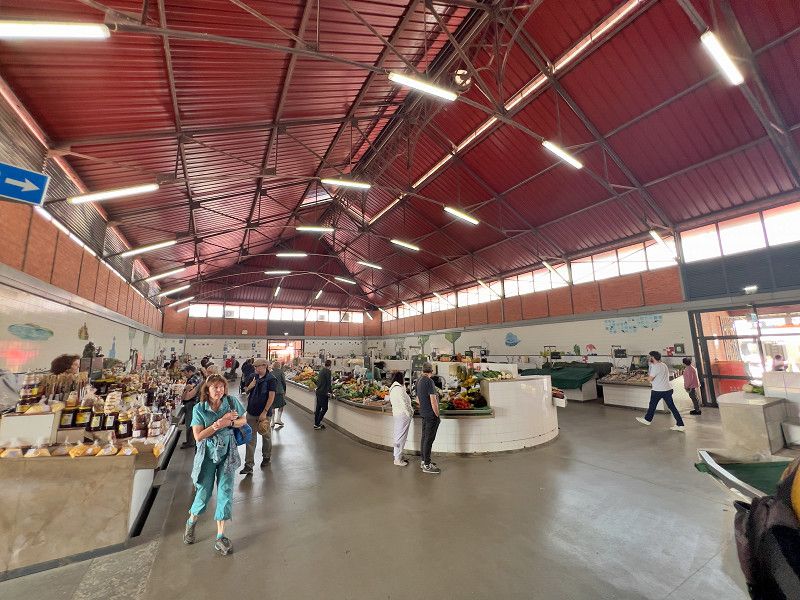
Today we walked to the harbor to take the catamaran to Cadiz. The 35-minute trip costs just €2.50 per person. We Frankfurters can only be amazed in disbelief, because two stops on the subway cost more here. From the harbor in Cadiz we go straight to the old town. Via the Plaza de San Juan de Dios we get to the cathedral, an impressive building. As before, the tour costs a "donation". There is no church tax. Instead, there is a free audio guide in German on your cell phone. After our tour, I climb one of the two church towers and enjoy the view over Cadiz. Next, we marvel at the abundance of fish and seafood in the Mercado Central, where we get something to eat at one of the many tapas stands. We cross Cadiz on the way to the Castello de Santa Catalina, the former prison, from where you are supposed to have a great view of Cadiz and the beach. Well, we weren't convinced by the view. On the way back we stop at the Torre Tavira, the highest watchtower in Cadiz. These were once used to monitor shipping traffic in the Bay of Cadiz to ensure that all ships paid their dues properly. From here you also have a beautiful panoramic view and it also has a camera obscura. Unfortunately, photography was not allowed during the performance. We walk through the former Jewish quarter with its four preserved gates back to the harbor to take the 5 p.m. ferry back.
Calle Alcalá Galiano 3, Cádiz, Bahía de Cádiz, Andalusien, Spanien
36° 31' 52.6" N 6° 17' 54.3" W
36.5312846 -6.2984098
• Head toward Calle Hospital de Mujeres on Calle José de Dios. Go for 11 m.
• Turn right onto Calle Hospital de Mujeres. Go for 55 m.
• Turn left onto Calle San Francisco Javier. Go for 100 m.
• Turn left onto Calle Robles. Go for 16 m.
• Turn right onto Calle Cruz. Go for 35 m.
• Continue on Plaza Cruz Verde. Go for 7 m.
• Continue on Calle Cruz. Go for 141 m.
• Turn left onto Calle Regimiento Infantería de Cádiz. Go for 28 m.
• Turn right onto Calle Abreu. Go for 25 m.
• Turn right onto Avenida Campo del Sur. Go for 424 m.
• Turn right onto Calle San Félix. Go for 56 m.
• Turn right onto Calle Venezuela. Go for 84 m.
• Turn right onto Calle Arricruz. Go for 64 m.
• Turn left onto Avenida Campo del Sur. Go for 1.0 km.
• Continue on Calle Concepción Arenal. Go for 193 m.
• Continue on Calle Murallas de San Roque. Go for 6 m.
• Take the 2nd exit from roundabout onto Calle Murallas de San Roque. Go for 131 m.
• Turn right onto Plaza de la Constitución toward San Fernando/N-4/Algeciras/N-340/Puerto Real/N-443/Sevilla/A-4. Go for 201 m.
• Continue on Avenida Andalucía. Go for 1.4 km.
• Continue on Plaza San José. Go for 30 m.
• Continue on Avenida Ana de Viya. Go for 681 m.
• Continue on Avenida Cayetano del Toro. Go for 827 m.
• Continue on Avenida Periodista Beatriz Cienfuegos. Go for 676 m.
• Keep right onto Avenida Vía Augusta Julia. Go for 13.0 km.
• Continue on A-48 (Autovía de la Costa de la Luz). Go for 36.3 km.
• Take exit 36 toward Vejer de la Frontera/A-2229/Los Caños de Meca/A-2233. Go for 245 m.
• Take the 2nd exit from roundabout toward Vejer/A-2229/Los Caños de Meca/A-2233/El Palmar. Go for 216 m.
• Take the 5th exit from roundabout onto A-2229. Go for 1.8 km.
• Continue on Calle Los Remedios (A-2229). Go for 198 m.
• Arrive at Calle Los Remedios (A-2229). Your destination is on the left.
☍
57,9 km
( 46 min.)
Vejer de la Frontera
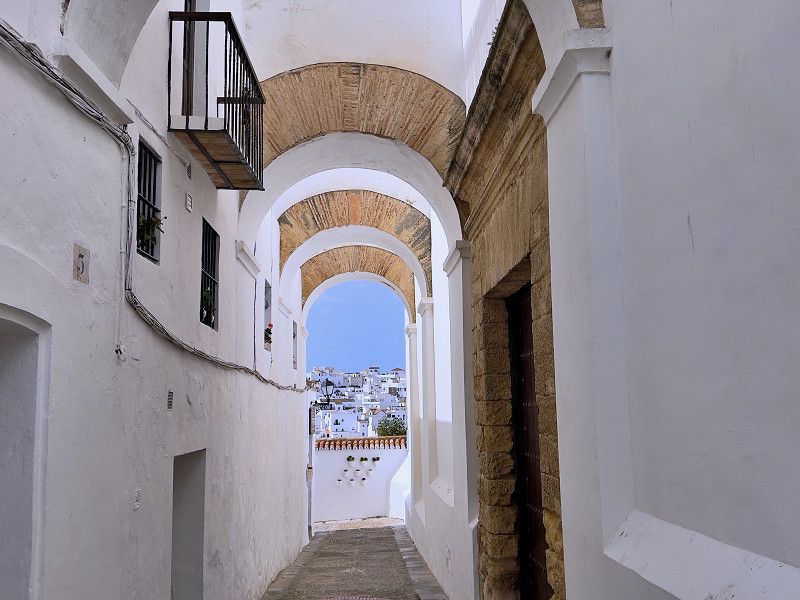
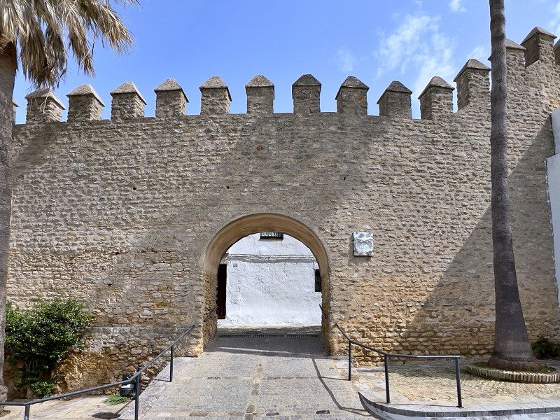
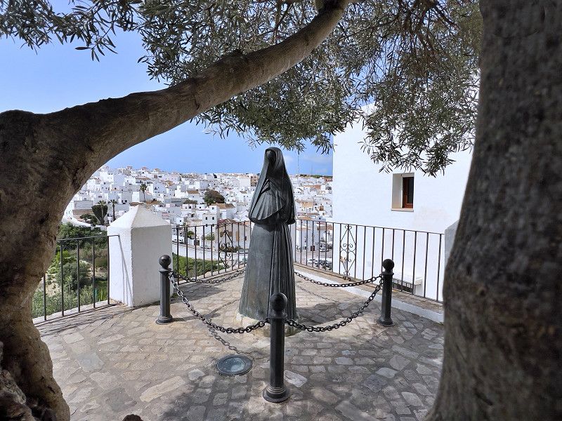
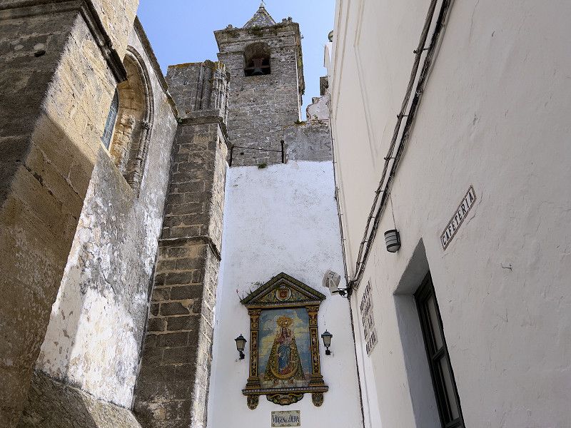
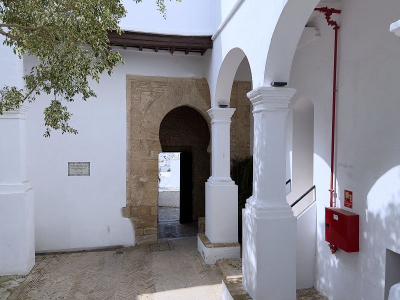
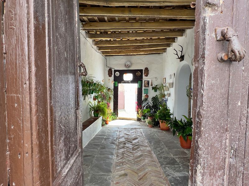
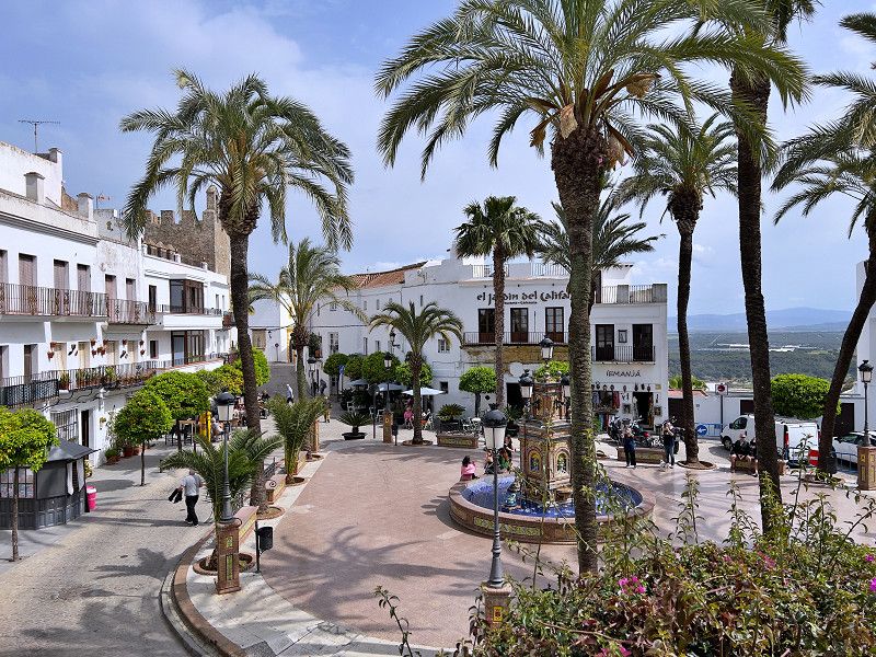
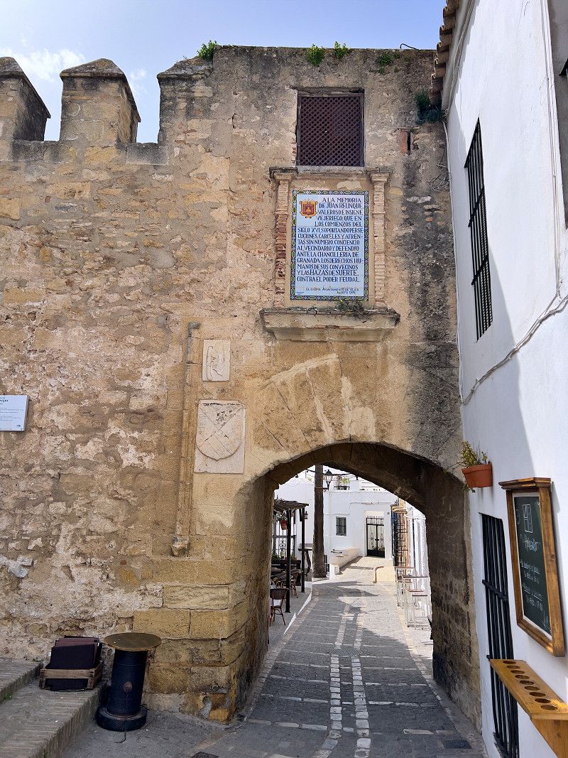
Vejer is, we read, one of the most beautiful white villages in Andalusia with a completely preserved old town on a 200-meter-high ridge. We park our car in a large car park at the foot of the old town, right next to the tourist information office. We get our obligatory city map and start the climb up to the old town. The winding and constantly branching alleys were probably intended to make it difficult for attackers to find their way around, but today it is the tourists who sometimes seem a little lost. The main attractions, besides the town itself, are the preserved city wall with its gates, especially the Nuns' Gate, which formed the entrance to the former Jewish quarter. The Castillo can be viewed from the outside and offers a beautiful view over Verja. The highlight, however, is the Plaza de Espagña with its tiled fountain, palm trees, bars and restaurants. After we have fortified ourselves, we slowly make our way back to the car.
La Janda, Andalusien, Spanien
36° 15' 19.8" N 5° 58' 4.8" W
36.2554984 -5.9680049
• Head southwest on Calle Los Remedios (A-2229). Go for 46 m.
• Take the 3rd exit from roundabout onto Calle Los Remedios (A-2229). Go for 337 m.
• Continue on A-2229. Go for 1.7 km.
• Take the 2nd exit from roundabout toward La Muela/E-5/A-48/Cadiz/Algeciras. Go for 182 m.
• Take the 1st exit from roundabout onto A-48 (Autovía de la Costa de la Luz) toward N-340/Algeciras/Málaga. Go for 659 m.
• Continue on N-340. Go for 1.3 km.
• Take the 2nd exit from roundabout onto A-396. Go for 22.3 km.
• Turn right onto A-396 toward CA-203/Medina Sidonia. Go for 780 m.
• Take the 1st exit from roundabout onto A-396 toward A-381/Los Barrios/Paterna. Go for 3.3 km.
• Take the 2nd exit from roundabout onto A-2234 toward A-389. Go for 4.0 km.
• Take the 1st exit from roundabout onto A-389 toward Paterna. Go for 13.2 km.
• Continue on A-389. Go for 21.0 km.
• Take the 1st exit from roundabout onto Avenida del Retiro (A-382a) toward Jédula/Jerez. Go for 307 m.
• Take the 1st exit from roundabout onto Avenida Miguel Mancheño. Go for 403 m.
• Take the 1st exit from roundabout onto Avenida Duque de Arcos. Go for 318 m.
• Turn right. Go for 32 m.
• Turn left. Go for 64 m.
• Arrive at your destination on the right.
☍
69,8 km
( 54 min.)
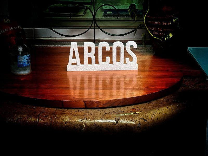
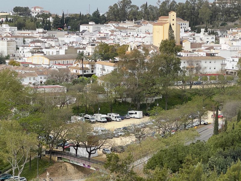
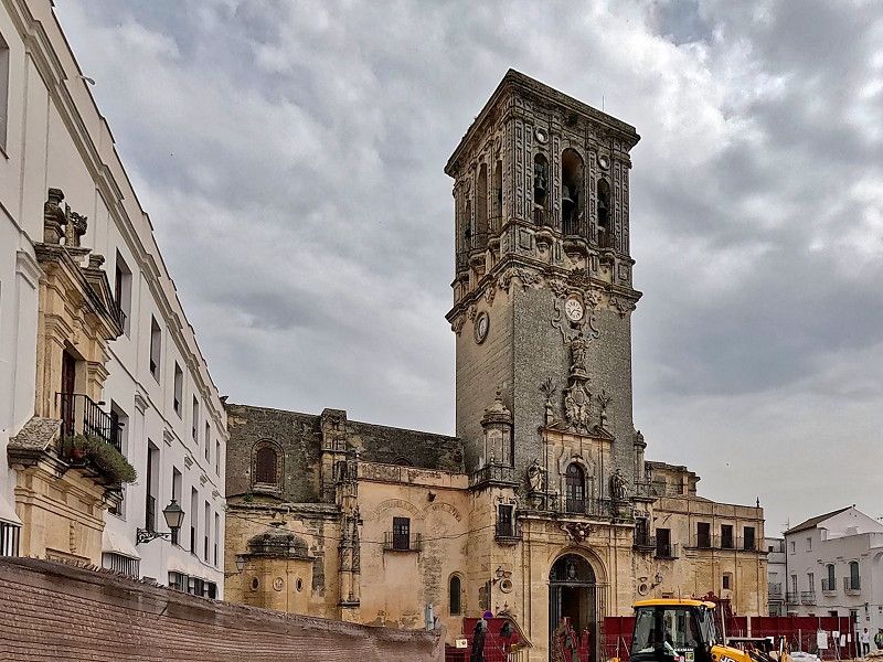
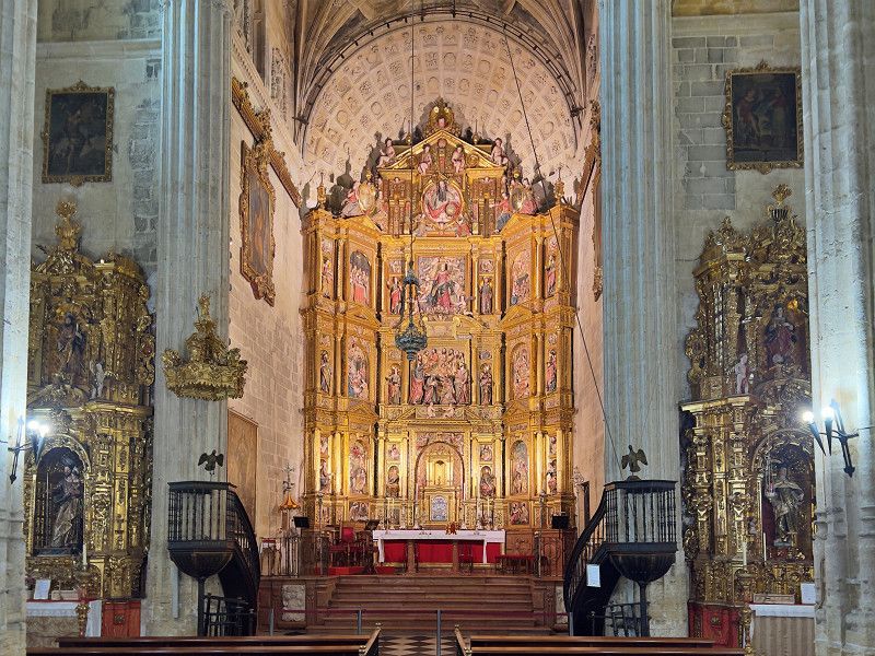
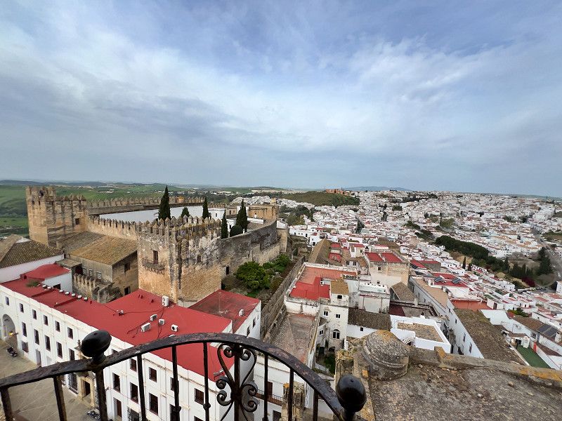
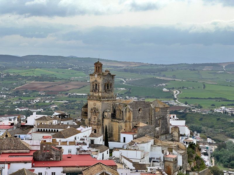
Arcos de la Frontera
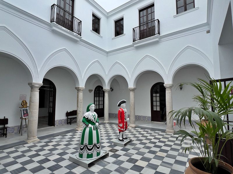
Our journey to the white villages continues to Arcos de la Frontera. We are standing in a large car park from which a footbridge and stairs lead directly into the old town. Arcos also dates back to a Moorish settlement, and the castle alone is almost 1,000 years old. Unfortunately, it cannot be visited as it is privately owned. It is also located on a ridge high above the Rio Guadalete. And here too, the whitewashed houses, churches and narrow streets are the main attractions. The Basilica of Santa de la Asunción and the Church of San Pedro, both from the 16th century, are magnificent. The churches had a bitter dispute for a long time over which was the town church of Arcos. The dispute was finally brought before the Pope, who elevated the basilica to the status of the town church. From the tower of the basilica and from the lookout point on the church square, there is a beautiful view of the town and the countryside.
Calle Antonio y Carlos Murciano, Arcos de la Frontera, Sierra de Cádiz, Andalusien, Spanien
36° 44' 58.4" N 5° 48' 53.6" W
36.7495645 -5.8149005
• Head northwest. Go for 64 m.
• Turn right toward Avenida Duque de Arcos. Go for 32 m.
• Turn left onto Avenida Duque de Arcos. Go for 299 m.
• Take the 1st exit from roundabout onto Avenida Miguel Mancheño. Go for 398 m.
• Take the 1st exit from roundabout onto Calle Miguel Macheño (A-382a) toward Antequera. Go for 496 m.
• Pass 3 roundabouts and continue on Avenida Ponce de León (A-382a). Go for 1.3 km.
• Take the 3rd exit from roundabout onto A-382a toward Antequera/A-384. Go for 381 m.
• Take the 3rd exit from roundabout onto A-384 toward Antequera. Go for 777 m.
• Take the 2nd exit from roundabout onto A-384. Go for 48.0 km.
• Keep left onto A-374/A-384 toward El Gastor/Ronda. Go for 2.5 km.
• Turn left onto CA-9109 toward Setenil. Go for 5.5 km.
• Turn right onto CA-9111 toward El Gastor/Setenil/Alcalá del Valle. Go for 1.1 km.
• Turn left onto CA-9113 toward Setenil/Alcalá del Valle. Go for 984 m.
• Continue on Rancho Perolas (CA-9113). Go for 90 m.
• Continue on CA-9113. Go for 12.1 km.
• Continue on Calle San Sebastián. Go for 144 m.
• Turn left onto Calle Trasera San Sebastián. Go for 47 m.
• Turn right onto Calle Reyes Católicos. Go for 145 m.
• Continue on Calle Cádiz. Go for 156 m.
• Continue on Calle Vilches. Go for 17 m.
• Turn left onto Plaza de Andalucía. Go for 7 m.
• Turn slightly left onto Calle Callejón. Go for 63 m.
• Arrive at Calle Callejón. Your destination is on the left.
☍
74,7 km
(1 hrs. 7 min.)
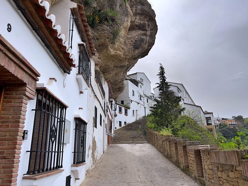
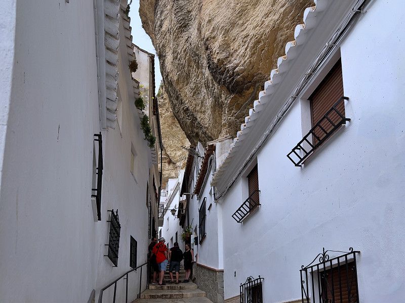
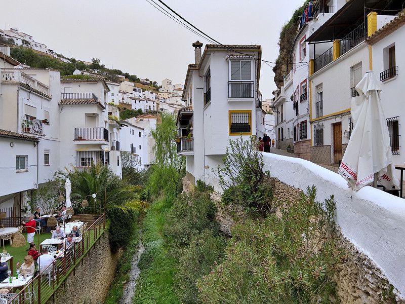
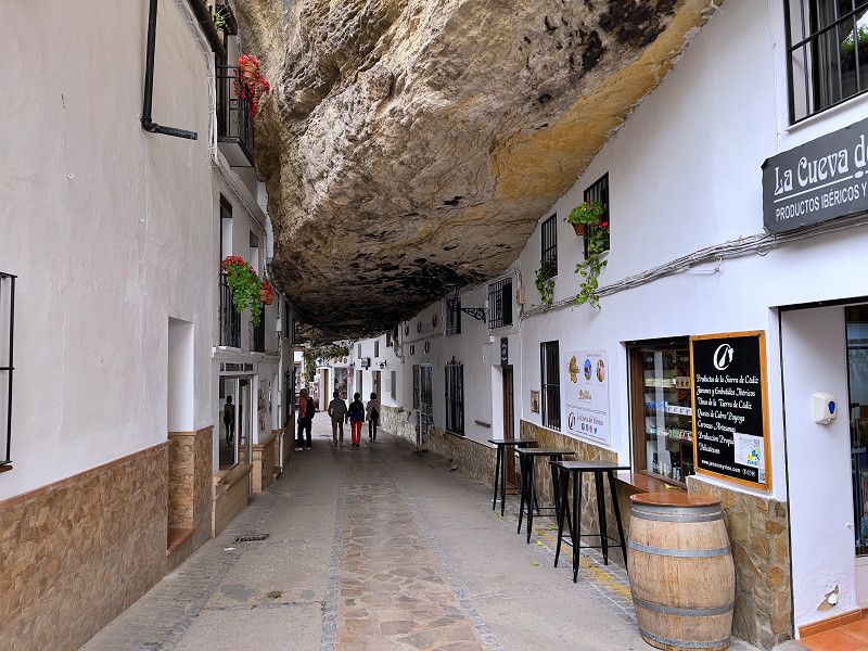
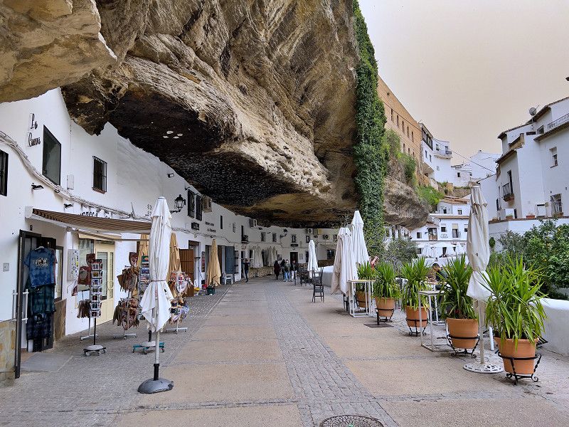
Setenil de las Bodegas
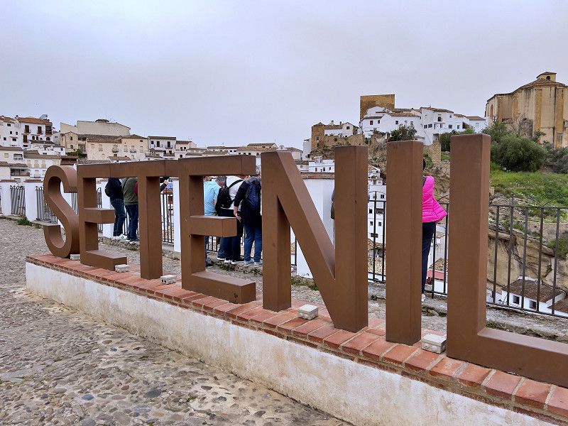
We visit Setinil, one of the white villages of Andalusia and known primarily from a photo. After the winding and sometimes steep drive, we park in the parking garage; there may be options for camper vans on the outskirts of town. We are quickly in the old town, although there are only a few sights besides the townscape. But most people come to Setenil anyway because of one special feature, namely the houses built in and under the cliff face.
Calle Callejón 11, Setenil de las Bodegas, Sierra de Cádiz, Andalusien, Spanien
36° 51' 50.4" N 5° 10' 54.5" W
36.8640009 -5.1818070
• Head northeast on Calle Callejón. Go for 63 m.
• Turn slightly right onto Plaza de Andalucía. Go for 7 m.
• Turn right onto Calle Vilches. Go for 17 m.
• Continue on Calle Cádiz. Go for 156 m.
• Continue on Calle Reyes Católicos. Go for 145 m.
• Turn left onto Calle Trasera San Sebastián. Go for 47 m.
• Turn right onto Calle San Sebastián. Go for 172 m.
• Continue on CA-9113. Go for 12.1 km.
• Continue on Rancho Perolas (CA-9113). Go for 90 m.
• Continue on CA-9113. Go for 984 m.
• Turn right onto CA-9111 toward Algodonales/Olvera. Go for 1.1 km.
• Turn left onto CA-9109. Go for 5.4 km.
• Turn right onto A-374 toward Algodonales/Sevilla. Go for 2.6 km.
• Keep left onto A-384 toward Villamartín/Jerez de la Frontera/A-375/Pto. Serrano/Sevilla. Go for 47.3 km.
• Continue on A-382. Go for 27.2 km.
• Continue on A-2005. Go for 365 m.
• Turn right onto CA-3105 toward N-4/Aeropuerto. Go for 299 m.
• Take the 3rd exit from roundabout onto N-349 toward Aeropuerto/A-4/Cádiz/Sevilla/El Pto. de Sta. María/Sanlúcar/Chipiona/Rota. Go for 3.3 km.
• Take the 3rd exit from roundabout onto A-4 (Autovía del Sur) toward Jerez de la Frontera/El Pto. de Sta. María/Sanlúcar/Chipiona/Rota. Go for 8.3 km.
• Take exit 639 toward Jerez/Trebujena. Go for 362 m.
• Take the 3rd exit from roundabout. Go for 182 m.
• Take the 1st exit from roundabout toward Jerez de la F. Go for 286 m.
• Take the 3rd exit from roundabout onto Avenida de Escandinavia toward Jerez. Go for 351 m.
• Turn right. Go for 256 m.
• Turn left toward Ronda Aurora Boreal. Go for 22 m.
• Turn right onto Ronda Aurora Boreal. Go for 334 m.
• Turn right. Go for 16 m.
• Turn left. Go for 194 m.
• Arrive at your destination on the left.
☍
111,8 km
(1 hrs. 23 min.)
Jerez de la Frontera
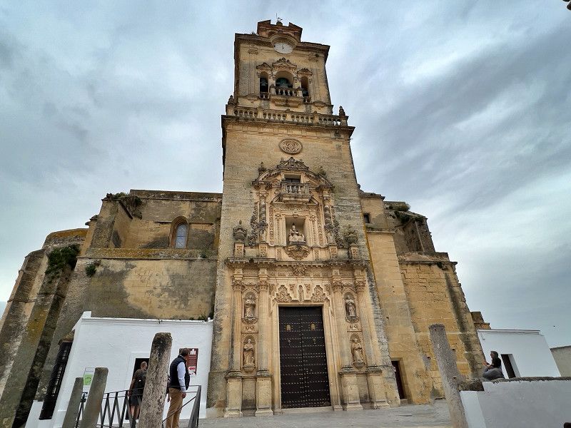
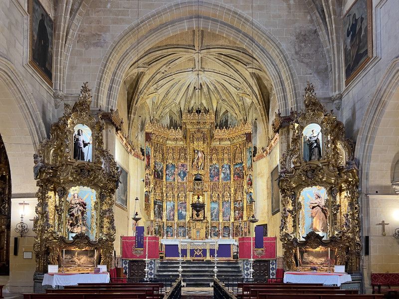
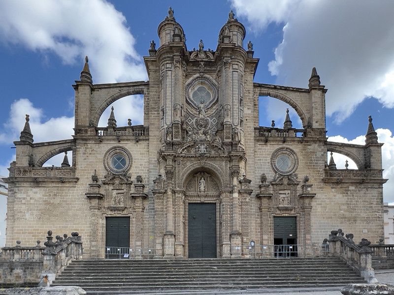
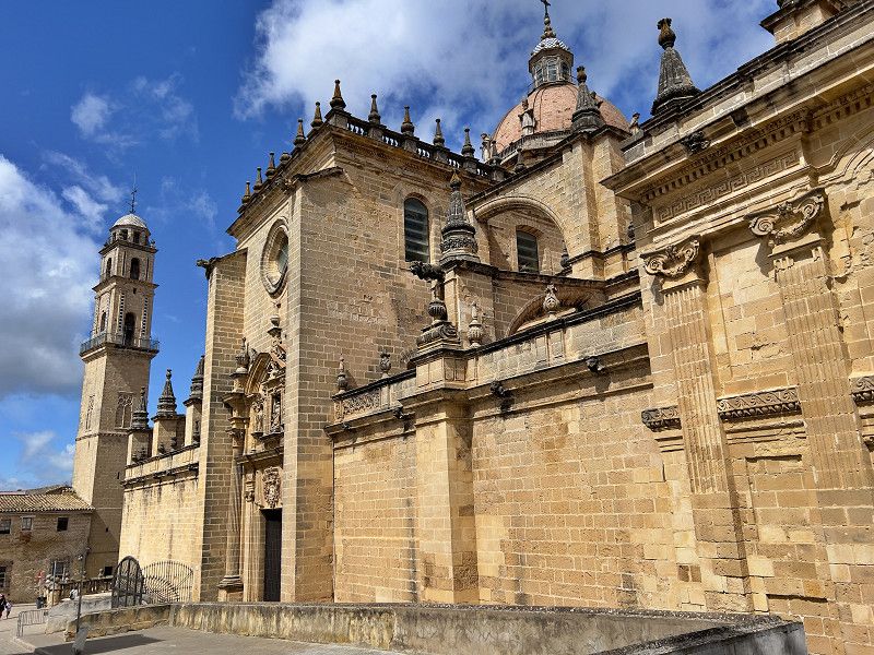
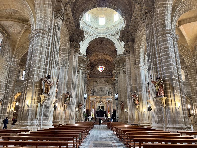
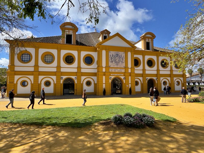
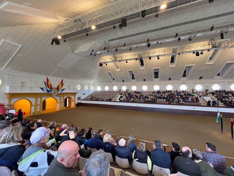
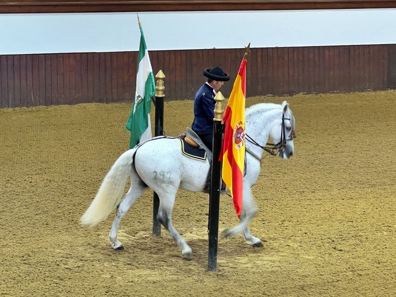
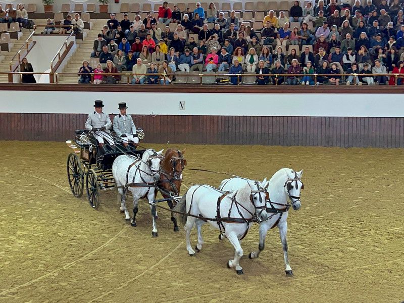
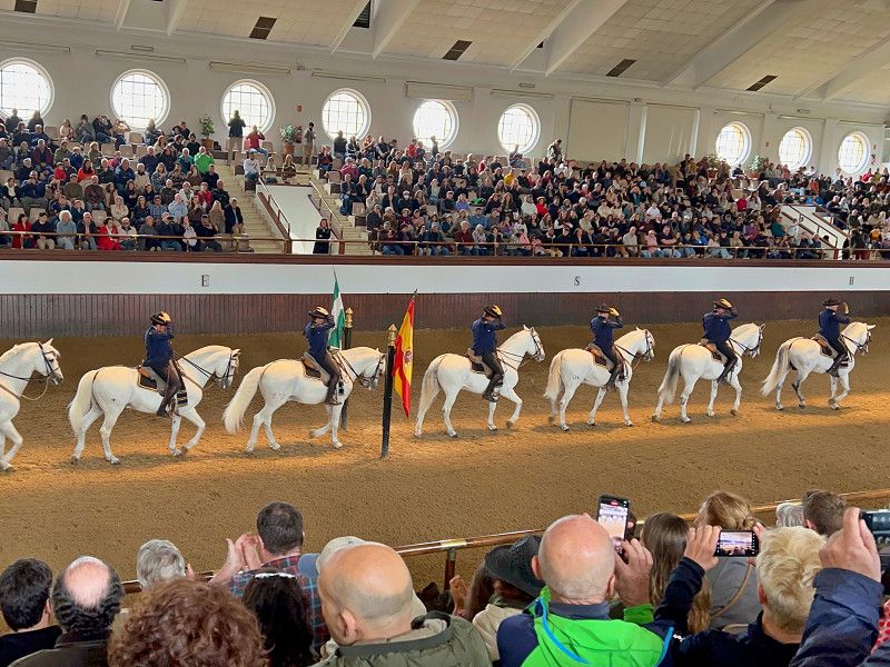
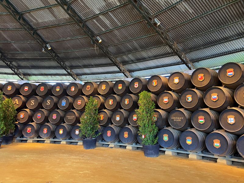
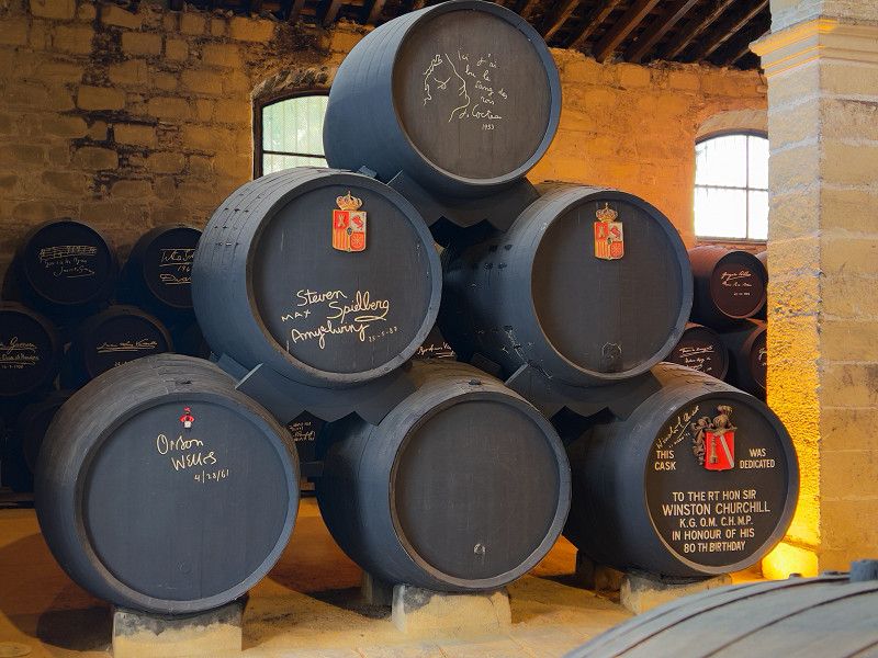
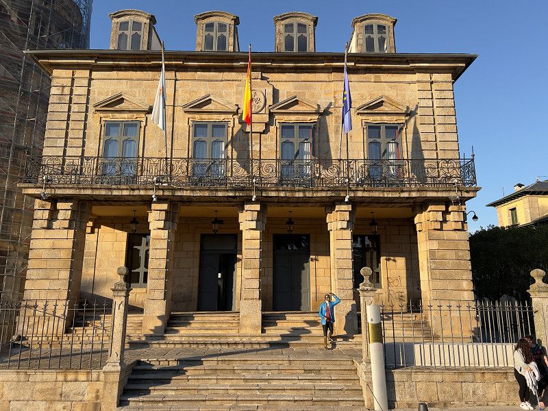
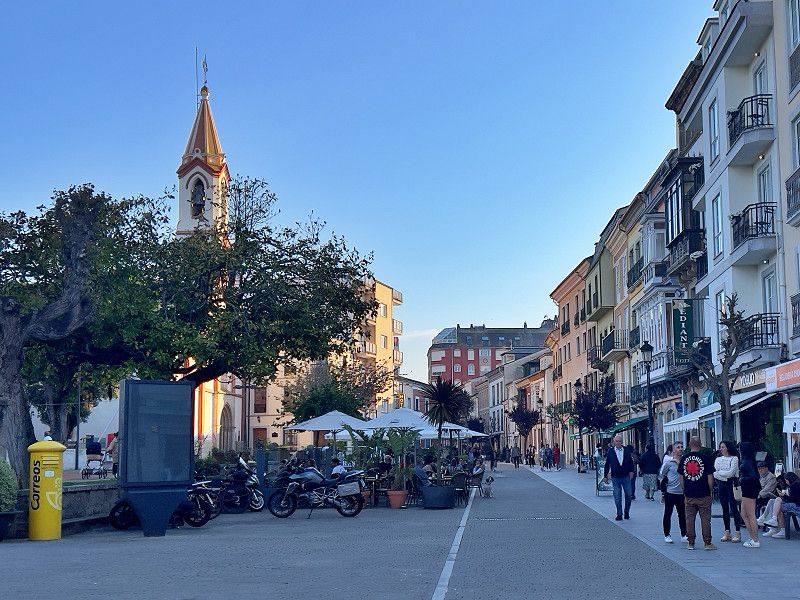
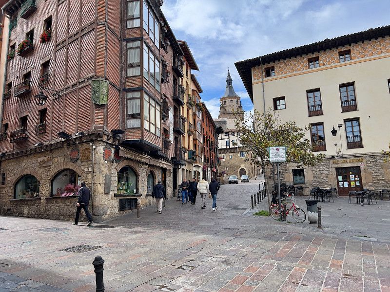
We reach our next destination, Jerez de la Frontera. The city has lived off sherry for centuries and the bodegas with their warehouses can even be found in the city center. But also the famous royal riding school. We start our tour at the old fortress, which unfortunately already closed. So to the cathedral of San Salvador, consecrated in 1778. Imposing and beautiful at the same time. Of the previous church from 1264, only the tower, which stands a little way off, remains. In the church museum area you can also enjoy a virtual flight through and around the church. Our route takes us further through the city, where we had booked a demonstration of the royal riding school online. The one-hour show was about horses in time with music. If you want more, you can also visit the stables and the museums.
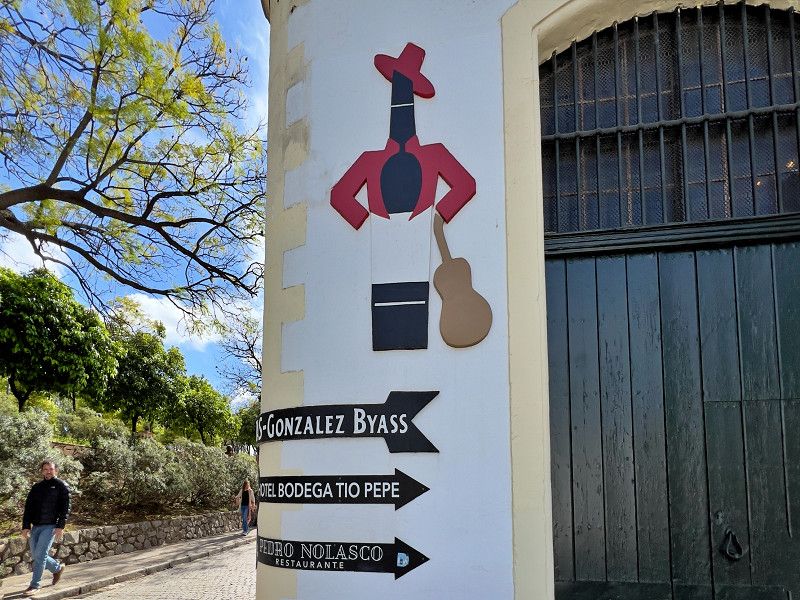
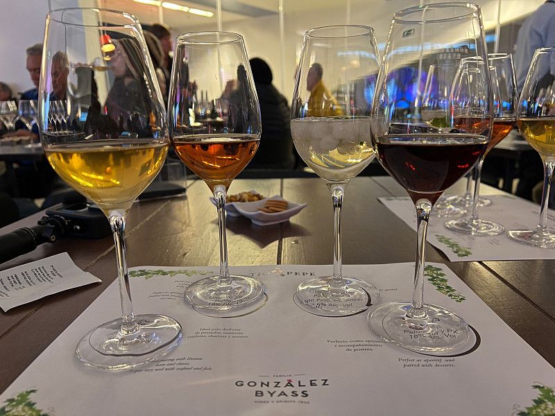
Now we want to visit a bodega and see how sherry is made. And of course we want to try it too. We also booked this one-hour tour in advance. We chose Gonzales-Byass, who produce the world's best-selling sherry with their Fino Tio Pepe and have been doing so for almost 200 years.
Calle Amanecer, Jerez, Campiña de Jerez, Andalusia, Spain
36° 41' 29.3" N 6° 9' 32.7" W
36.6914722 -6.1590915
• Head west. Go for 76 m.
• Turn right toward Ronda Aurora Boreal. Go for 60 m.
• Turn slightly right onto Ronda Aurora Boreal. Go for 372 m.
• Turn slightly right toward Calle del Mediodía. Go for 39 m.
• Continue on Calle del Mediodía. Go for 110 m.
• Take the 2nd exit from roundabout onto Avenida de Escandinavia toward E-5/A-4/Sevilla/Cadiz. Go for 668 m.
• Take the 3rd exit from roundabout toward A-4/E-5/Sevilla/Cadiz. Go for 329 m.
• Take the 1st exit from roundabout onto A-4 (Autovía del Sur) toward Aeropuerto/Sevilla. Go for 8.1 km.
• Take exit 631 toward Jerez/Arcos/E-5/Cádiz/AP-4/Sevilla. Go for 302 m.
• Take the 3rd exit from roundabout onto N-349 toward A-382/Arcos de la Frontera/E-5/AP-4/Cadiz/Sevilla. Go for 3.3 km.
• Take the 2nd exit from roundabout toward Arcos de la Frontera/Cádiz/Sevilla. Go for 567 m.
• Take left ramp onto AP-4 (Autopista del Sur) toward Sevilla. Go for 66.3 km.
• Continue on A-4 (Autopista del Sur). Go for 6.9 km.
• Take exit 549 toward Pol. Ind. La Isla/SE-30/Puerto Sevilla/E-1/Huelva/A-49/Mérida/A-66 onto SE-40. Go for 2.8 km.
• Continue on Carretera de la Esclusa (SE-31). Go for 1.4 km.
• Take the 2nd exit from roundabout onto Carretera de la Esclusa (SE-31). Go for 950 m.
• Pass 2 roundabouts and continue on Carretera de la Esclusa (SE-31). Go for 1.3 km.
• Take the 1st exit from roundabout onto Carretera de la Esclusa (SE-31). Go for 4.0 km.
• Turn right. Go for 867 m.
• Turn left. Go for 31 m.
• Turn slightly left. Go for 418 m.
• Arrive at your destination on the right.
☍
99,0 km
(1 hrs. 3 min.)
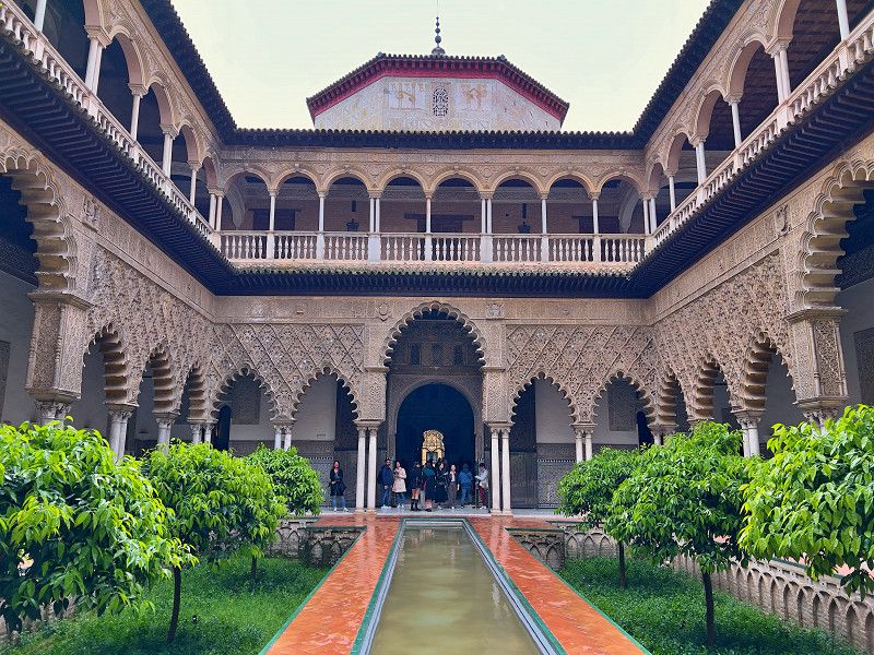
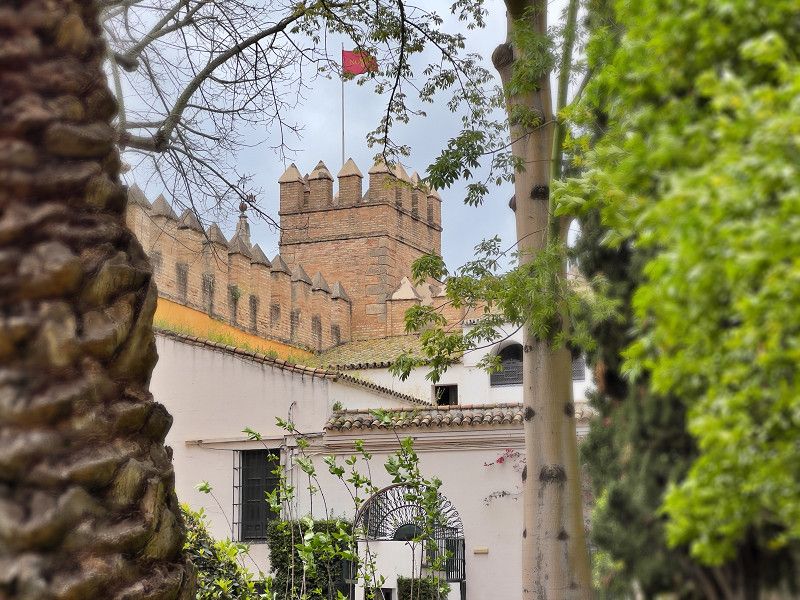
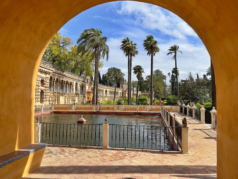
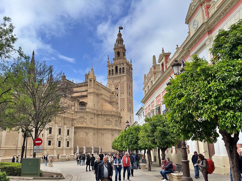
Sevilla
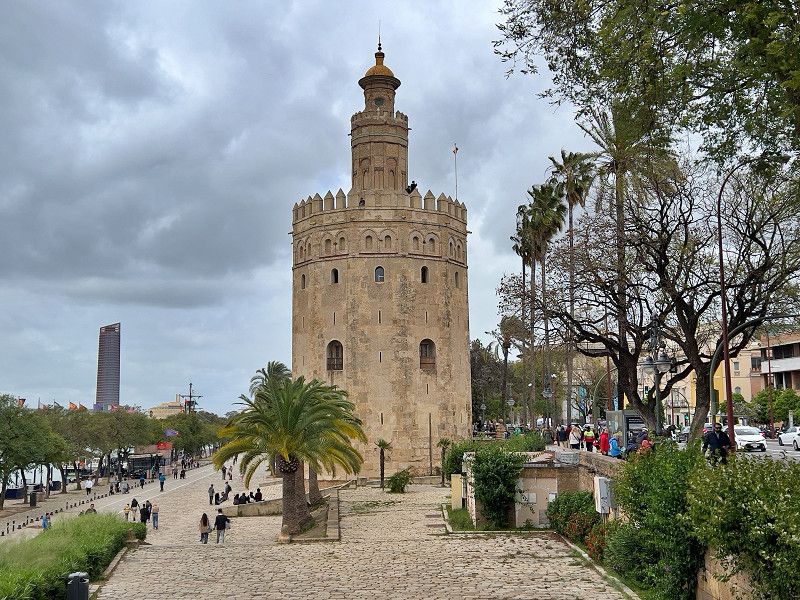
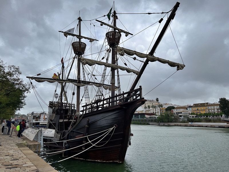
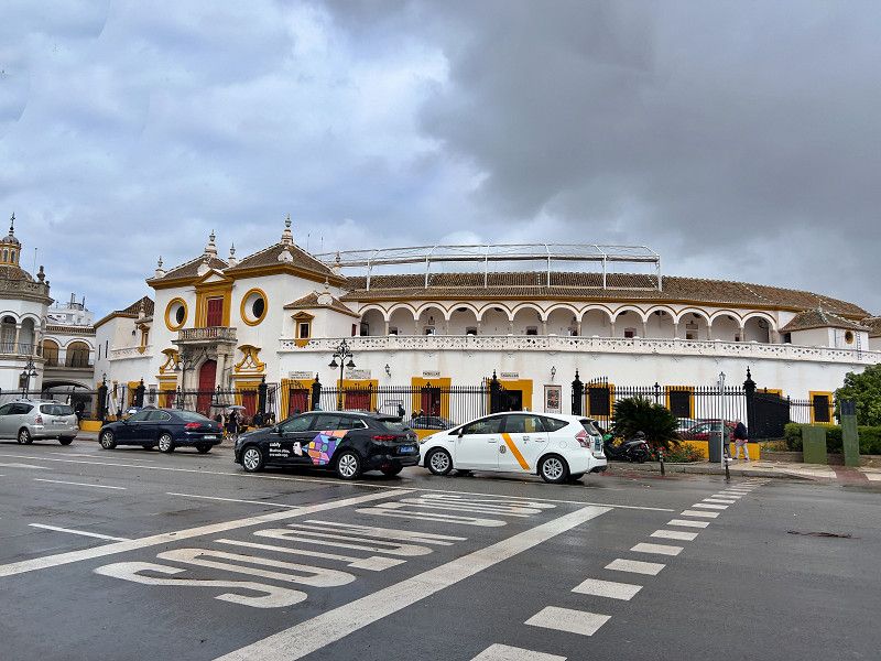
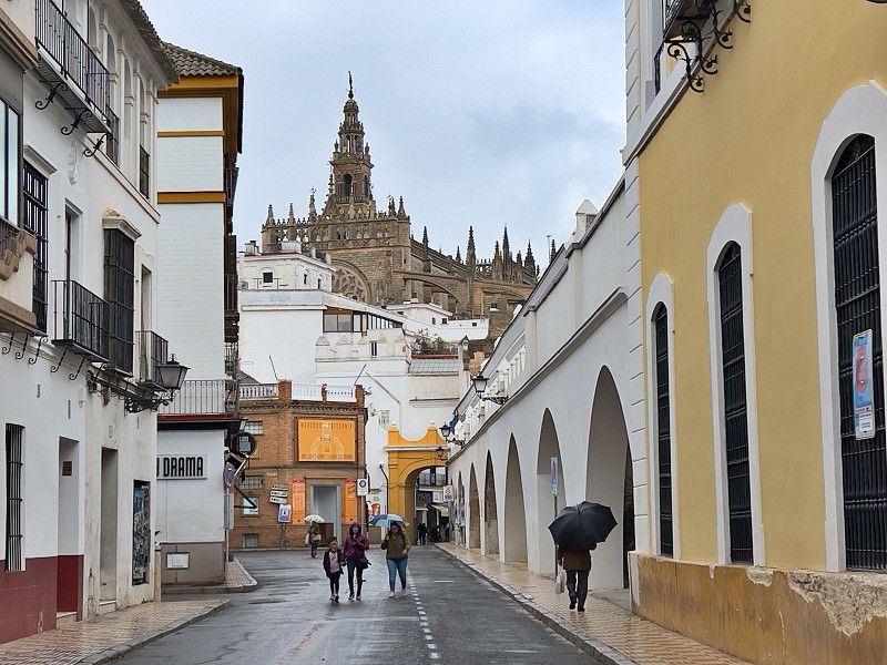
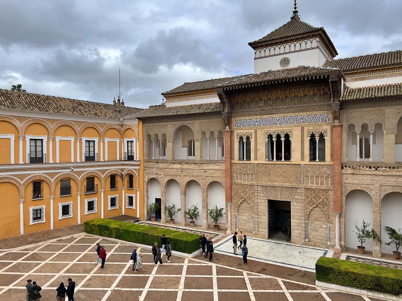
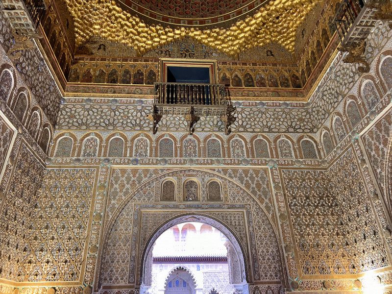
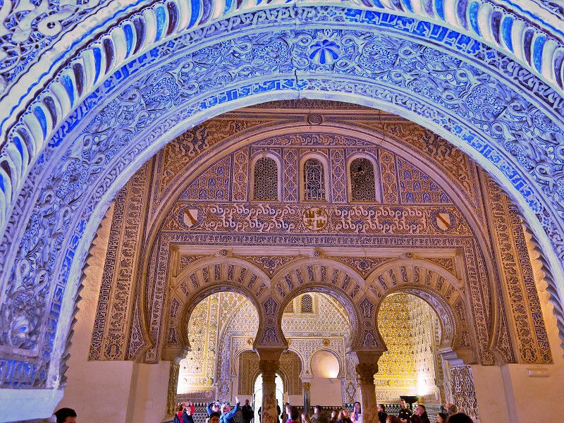
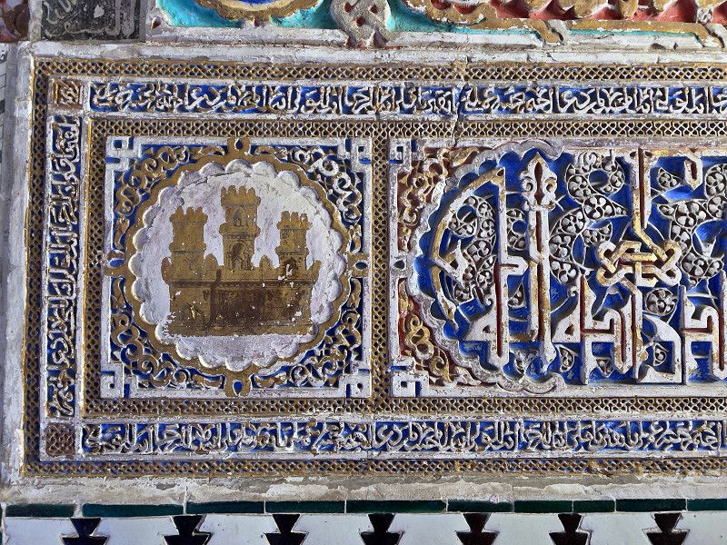
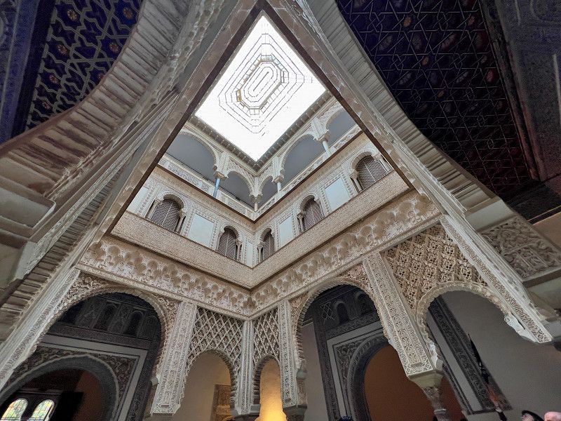
On our way to Portugal we also pay a visit to Seville, because here too we had to book a sight in advance. We park at a spot by the harbor, not picturesque but OK for a city tour. We walk half an hour into the city. And we're unlucky. Because of the strong wind that was predicted, all the parks in Seville are closed, including the beautiful Plaza de Espagna, one of the sights. So we first go back to the river and to the Torre d'Oro, an old city gate. We pass the replica of the 500-year-old Nao Victoria and the bullring and then go through the old town streets to the Real Alcazar, the former Moorish castle. The preserved Moorish palace part is beautiful and is very reminiscent of the Alhambra. But here too we couldn't visit the gardens and parks. What a pity. We were too exhausted to visit the cathedral. Next time...
Avenida Sanlúcar de Barrameda, Seville, Andalusia, Spain
37° 21' 41.3" N 5° 59' 41.6" W
37.3614722 -5.9948769
• Head south. Go for 1.2 km.
• Turn left. Go for 532 m.
• Turn sharp right. Go for 65 m.
• Turn slightly right. Go for 43 m.
• Take the 1st exit from roundabout. Go for 137 m.
• Turn right onto Carretera de la Esclusa (SE-31). Go for 660 m.
• Take the 2nd exit from roundabout toward SE-30. Go for 200 m.
• Take left ramp onto A-66 (Ronda Urbana Sur) toward Cádiz/A-4/Granada/A-92/Córdoba/A-4. Go for 3.0 km.
• Take exit 9A toward Cádiz onto A-4 (Autovía del Sur). Go for 13.3 km.
• Continue on AP-4 (Autopista del Sur). Go for 31.6 km.
• Take exit 44 toward Lebrija/A-471. Go for 1.2 km.
• Take the 2nd exit from roundabout onto A-471r toward Lebrija/A-471/Sanlúcar/Chipiona/A-480. Go for 751 m.
• Take the 2nd exit from roundabout onto A-471 toward Sanlúcar de Bda. Go for 46.0 km.
• Continue on A-480. Go for 5.0 km.
• Take the 3rd exit from roundabout onto A-480 toward Chipiona. Go for 620 m.
• Pass 5 roundabouts and continue on A-480. Go for 3.6 km.
• Take the 2nd exit from roundabout onto Avenida de la Construcción toward Pol. Ind. La Estación/A-491/Avenida de La Constitución/A-481/Rota. Go for 448 m.
• Take the 2nd exit from roundabout onto Avenida de la Construcción. Go for 222 m.
• Take the 2nd exit from roundabout onto Avenida de la Constitución. Go for 574 m.
• Take the 3rd exit from roundabout onto Avenida de la Constitución. Go for 372 m.
• Continue on Avenida del Esturión. Go for 60 m.
• Pass 2 roundabouts and continue on Avenida del Esturión. Go for 483 m.
• Continue on Avenida de la Laguna. Go for 305 m.
• Turn left onto Avenida Veredas. Go for 118 m.
• Arrive at Avenida Veredas. Your destination is on the left.
☍
110,5 km
(1 hrs. 15 min.)
Chipiona
We left Chipiona because of the rain and drove to Chipiona. The parking spot is much more attractive than the one in Seville. We also want to have our German gas bottle refilled later in Rota.
We sat out the rain and storm and since the sun finally shone again today, we were able to take a look at Chipione before moving on tomorrow.
Northwest Coast, Andalusia, Spain
36° 43' 22.2" N 6° 26' 4" W
36.7228467 -6.4344467
• Head toward Pago Pacheco on Avenida Veredas. Go for 118 m.
• Turn right onto Avenida de la Laguna. Go for 305 m.
• Continue on Avenida del Esturión. Go for 157 m.
• Pass 2 roundabouts and continue on Avenida del Esturión. Go for 379 m.
• Continue on Avenida de la Constitución. Go for 302 m.
• Take the 3rd exit from roundabout onto Avenida de la Constitución. Go for 624 m.
• Take the 1st exit from roundabout onto Avenida de la Construcción. Go for 214 m.
• Take the 2nd exit from roundabout onto Avenida de la Construcción. Go for 413 m.
• Take the 2nd exit from roundabout onto A-480 toward Sanlúcar. Go for 529 m.
• Pass 6 roundabouts and continue on A-480. Go for 8.8 km.
• Continue on A-471 toward AP-4/Trebujena/Lebrija/Las Cabezas/Sevilla/Sanlúcar de Barrameda. Go for 45.5 km.
• Take ramp toward Las Cabezas de San Juan/E-5/AP-4/Sevilla/Cádiz. Go for 618 m.
• Take the 1st exit from roundabout onto A-471r toward E-5/AP-4/Sevilla/Cádiz/Las Cabezas de San Juan. Go for 799 m.
• Take the 3rd exit from roundabout onto AP-4 (Autopista del Sur) toward Sevilla. Go for 33.2 km.
• Continue on A-4 (Autopista del Sur). Go for 13.1 km.
• Take the exit toward E-1/Huelva/A-49/Mérida onto A-66 (Ronda Urbana Sur). Go for 7.7 km.
• Take exit 17B toward Huelva onto A-49 (Autopista del V Centenario). Go for 133 km.
• Continue on A22 (Via Infante de Sagres). Go for 39.4 km.
• Take exit 15 toward N398/Olhão/Moncarapacho. Go for 648 m.
• Take the 2nd exit from roundabout onto N398 toward Moncarapacho. Go for 1.7 km.
• Continue on Caliços (N398). Go for 55 m.
• Continue on N398. Go for 538 m.
• Turn left onto M516-2. Go for 475 m.
• Continue on Rua Capitão Manuel Madeira Nobre (M516-2). Go for 594 m.
• Continue on M516-2. Go for 183 m.
• Continue on Marco (M516-2). Go for 60 m.
• Continue on M516-2. Go for 2.9 km.
• Continue on N125-5. Go for 701 m.
• Continue on Rua da Liberdade (N125-5). Go for 460 m.
• Take the 2nd exit from roundabout onto Avenida 25 de Abril. Go for 584 m.
• Take the 1st exit from Avenida 25 de Abril roundabout onto Avenida 25 de Abril. Go for 153 m.
• Arrive at Avenida 25 de Abril. Your destination is on the left.
☍
294,5 km
(2 hrs. 50 min.)
Fuzeta
We have now arrived in Portugal. Not very far yet, just as far as Fuzeta. It's good that we sat out the bad weather in Chipiona, because the sun is shining here again. We're staying at the campsite for a few days, strolling through the harbor and the market, and will go on a bike ride to Olhão. But we have already found a "lost place"...
Rua Coronel Brandeiro, Moncarapacho e Fuseta, Faro, Portugal
37° 3' 13" N 7° 44' 42.2" W
37.0536207 -7.7450442
• Head toward Rua da Liberdade on Avenida 25 de Abril. Go for 170 m.
• Continue on Rua General Humberto Delgado. Go for 374 m.
• Continue on Rua da Ponte Grande. Go for 1.6 km.
• Turn left onto N125. Go for 5.4 km.
• Take the 3rd exit from roundabout onto N125. Go for 1.5 km.
• Take the 3rd exit from roundabout onto Avenida Heróis de 1808. Go for 846 m.
• Take the 1st exit from Rotunda das Operárias Conserveiras roundabout onto Avenida dos Operários Conserveiros. Go for 508 m.
• Take the 2nd exit from roundabout onto Avenida das Forças Armadas. Go for 548 m.
• Turn right onto Avenida 5 de Outubro. Go for 433 m.
• Arrive at Avenida 5 de Outubro. Your destination is on the right.
☍
11,4 km
( 15 min.)
Olhão
We unpacked our eBikes and rode to the neighboring town of Olhão. We cycled past salt pans with flamingos and storks and almost into the town. We went through the pedestrian zone (yes, there is one here too) to the market hall. It was amazing what kind of fish the Portuguese eat. There was everything there, from sole to rays. And all around, lots of little restaurants. Eating a little something with a view of the marina - simply beautiful.
Praça Patrão Joaquim Lopes, Olhão, Faro, Portugal
37° 1' 26.3" N 7° 50' 27.8" W
37.0239743 -7.8410539
• Head west on Avenida 5 de Outubro. Go for 621 m.
• Take the 2nd exit from roundabout onto Avenida 5 de Outubro. Go for 989 m.
• Take the 2nd exit from roundabout onto N125. Go for 2.2 km.
• Take the 1st exit from roundabout onto N125. Go for 2.1 km.
• Take the 2nd exit from roundabout onto N125 toward Faro. Go for 3.8 km.
• Continue on N125-10. Go for 1.5 km.
• Take ramp onto IC4 toward A22/Loulé/Lisboa/Portimão/Albufeira/IP1. Go for 4.4 km.
• Keep left onto IC4 toward Espanha/A22/Albufeira/Lisboa/A2/Loulé/Estádio Algarve. Go for 3.1 km.
• Keep left toward N125-4/Loulé/A22/Lisboa/A2. Go for 349 m.
• Take ramp onto A22 (Via Infante de Sagres) toward Albufeira/Lisboa/Portimão. Go for 45.5 km.
• Take exit 6 toward N124-1/Lagoa/Silves. Go for 270 m.
• Take the 1st exit from roundabout onto N124-1 toward Silves. Go for 4.3 km.
• Turn left onto N124-1. Go for 225 m.
• Turn left onto N124. Go for 275 m.
• Continue on Estrada Nacional 124 (N124). Go for 59 m.
• Continue on N124. Go for 180 m.
• Turn right toward N124. Go for 30 m.
• Take the 1st exit from roundabout onto N124. Go for 363 m.
• Take the 3rd exit from roundabout. Go for 271 m.
• Arrive at your destination on the right.
☍
70,4 km
( 47 min.)
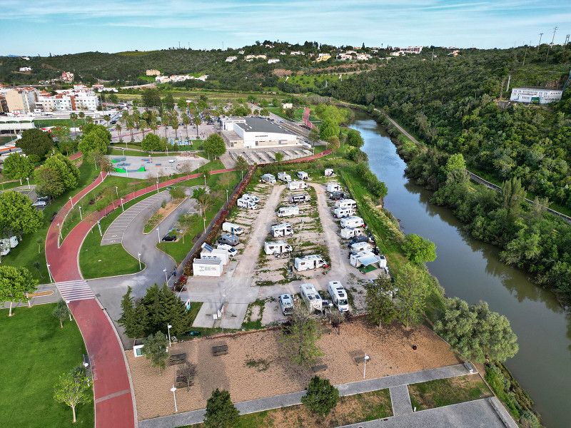
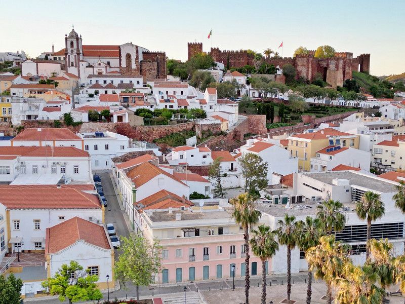
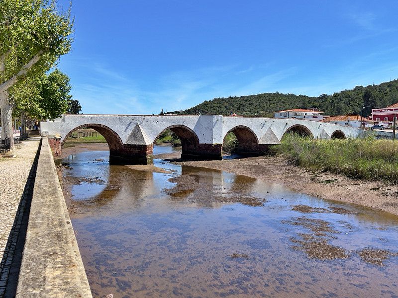
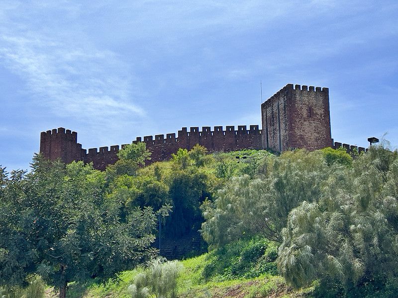
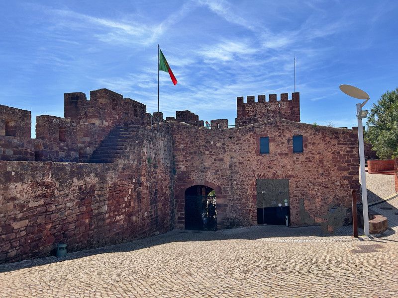
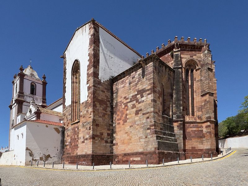
Silves
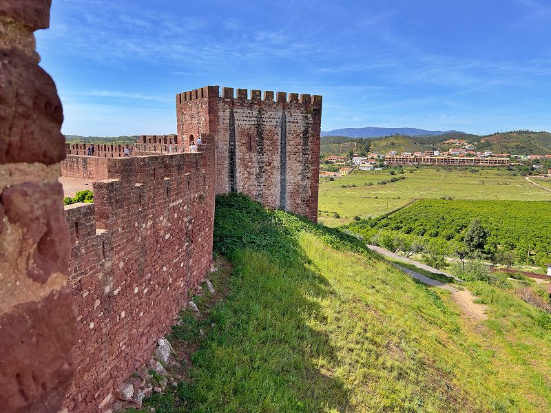
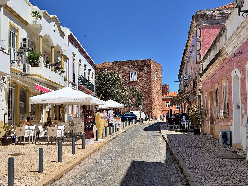
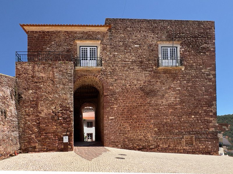
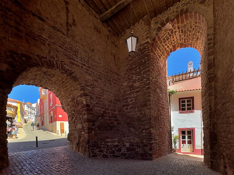
Silves' heyday began with the Arab occupation in the 8th century and owes its prosperity to the Arade River. From Silves, ships sailed as far as North Africa. In the 11th century, Xelb (Silves) became the capital of the Al-Gharb region. After the reconquest by crusaders in the 13th century, the city lost influence and wealth as the river became silted up.
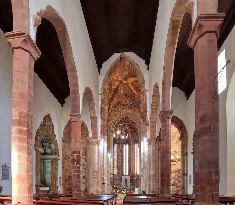
Today, Silves is a beautiful, tranquil place with many bars and restaurants and a number of sights, such as the red castle built by the Moors, the Sé Velha Cathedral, which was the seat of a bishop until the 16th century, the mighty city gate Porta da Cidade and the Cruz de Portugal. Silves is definitely worth a visit.
Percurso Pedonal Ribeirinho, Silves, Faro, Portugal
37° 11' 6.6" N 8° 26' 43.1" W
37.1851701 -8.4453132
• Head east.
• Turn slightly right toward N124. Go for 288 m.
• Take the 1st exit from roundabout onto N124. Go for 337 m.
• Take the 2nd exit from roundabout onto N124. Go for 260 m.
• Continue on Estrada Nacional 124 (N124). Go for 59 m.
• Continue on N124. Go for 232 m.
• Turn right onto N124-1. Go for 197 m.
• Turn right onto N124-1. Go for 4.2 km.
• Continue toward Via Infante de Sagres/A22. Go for 43 m.
• Take the 1st exit from roundabout onto A22 (Via Infante de Sagres) toward Lagos/Portimão. Go for 23.3 km.
• Take exit 2 toward (N125)/Odiáxere/Lagos Este. Go for 3.6 km.
• Take the 1st exit from roundabout onto N125. Go for 922 m.
• Take the 2nd exit from roundabout onto N125. Go for 936 m.
• Take the 2nd exit from roundabout onto N125. Go for 1.8 km.
• Take the 4th exit from roundabout onto N125 toward Portimão/Meia Praia. Go for 530 m.
• Turn right onto N125 toward Meia Praia. Go for 104 m.
• Turn right. Go for 144 m.
• Turn right. Go for 83 m.
• Arrive at your destination on the left.
☍
37,0 km
( 26 min.)
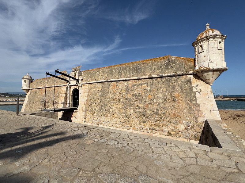
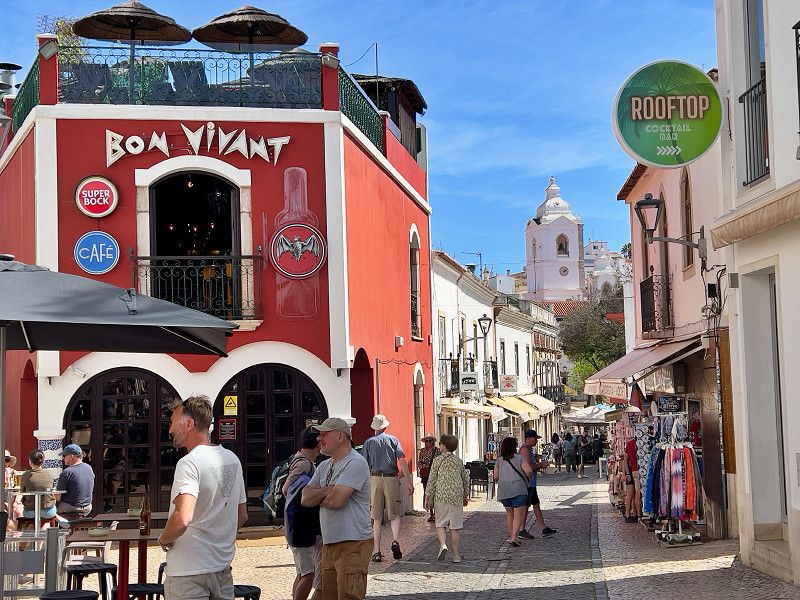
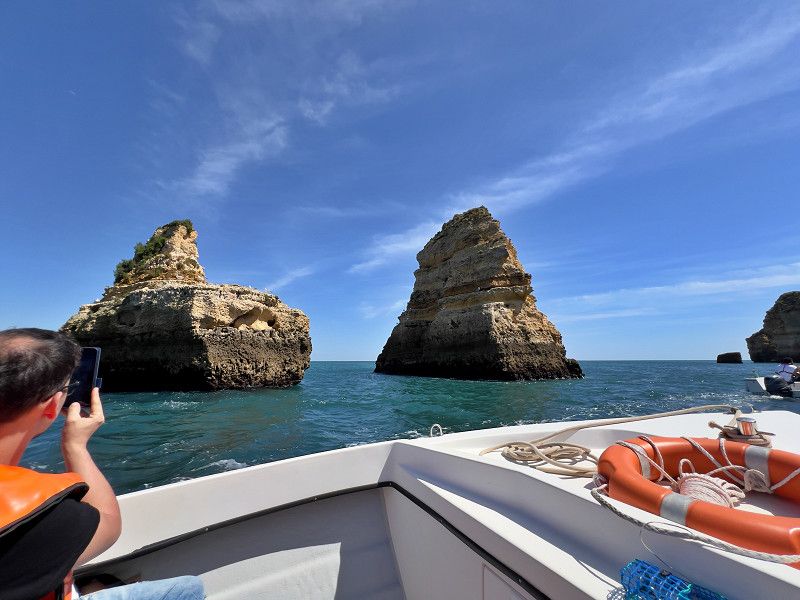
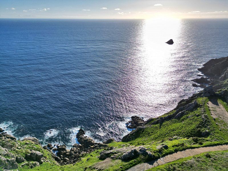
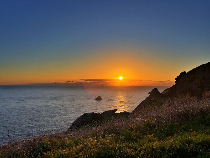
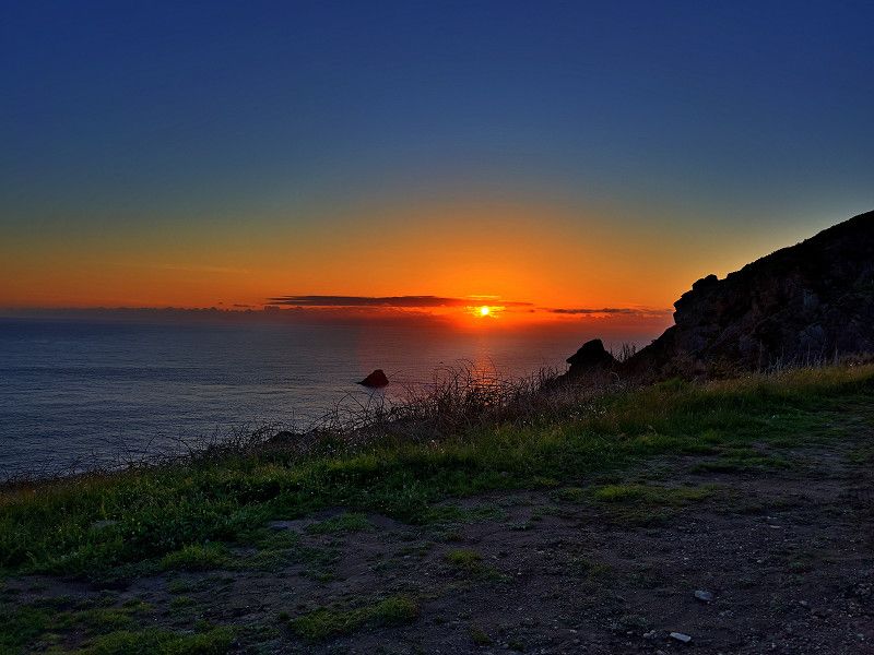
Lagos
We skipped Faro (due to a lack of parking spaces near the city) and drove straight to Lagos. As we were a little late, we spent the night on a parking space near a supermarket. Even though we had a fairly quiet night, we continued on the next day, especially as the journey into the city was a little too far for us.
Faro, Portugal
37° 6' 48.3" N 8° 40' 38.2" W
37.1134274 -8.6772664
• Head northeast. Go for 90 m.
• Turn left toward Ponte Dona Maria II/N125. Go for 88 m.
• Turn right onto Ponte Dona Maria II (N125). Go for 212 m.
• Continue on N125. Go for 34 m.
• Take the 3rd exit from roundabout onto Avenida dos Descobrimentos (N125). Go for 2.0 km.
• Continue on Avenida das Comunidades Portuguesas (N125). Go for 411 m.
• Take the 1st exit from roundabout onto Rua do Baluarte. Go for 224 m.
• Turn right onto Estrada da Ponta da Piedade (M536). Go for 185 m.
• Turn left. Go for 38 m.
• Turn left. Go for 71 m.
• Arrive at your destination on the right.
☍
3,3 km
( 6 min.)
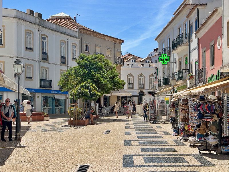
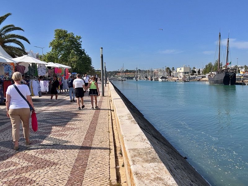
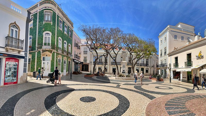
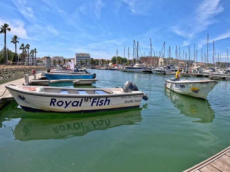
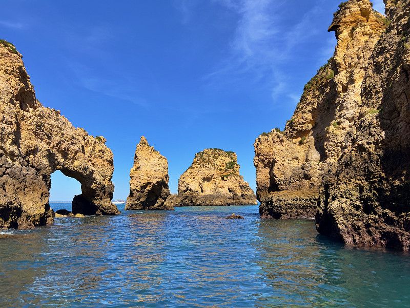
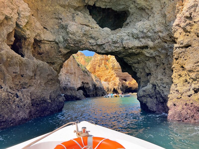
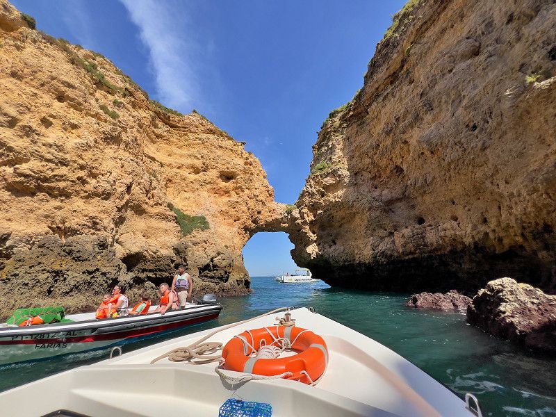
Lagos
We chose the Lagos campsite. Despite its somewhat "morbid" charm (the upstairs sanitary facilities are functional and clean), it has the advantage of being quite centrally located; you can reach the old town on foot in 10 minutes. And we are in a quiet spot, have enough space and see for the first time the beautiful blue magpies that live in this area.
Rua Professor Correia Abreu, Lagos, Faro, Portugal
37° 5' 39.2" N 8° 40' 17.2" W
37.0942229 -8.6714529
• Head northwest. Go for 71 m.
• Turn right toward Estrada da Ponta da Piedade/M536. Go for 38 m.
• Turn right onto Estrada da Ponta da Piedade (M536). Go for 285 m.
• Turn right onto Estrada da Ponta da Piedade. Go for 122 m.
• Continue on Praça d'Armas. Go for 41 m.
• Continue on Travessa do Forno. Go for 96 m.
• Turn left onto Rua 5 de Outubro. Go for 32 m.
• Turn left onto Travessa do Cotovelo. Go for 39 m.
• Continue on Rua Cândido dos Reis. Go for 151 m.
• Turn right onto Rua Dr. Joaquim Tello. Go for 120 m.
• Turn right onto Rua 25 de Abril 1974. Go for 77 m.
• Continue on Rua Silva Lopes. Go for 118 m.
• Arrive at Rua Silva Lopes.
☍
1,2 km
( 3 min.)
Lagos
Our first destination on our city tour is the Church of Santo Antonio, which is part of the municipal museum "Dr. José Foirmosinho". Alongside various smaller collections, the church is the main attraction and absolutely worth a visit. You have to see it with your own eyes.
Rua General Alberto da Silveira, Lagos, Faro, Portugal
37° 5' 58.9" N 8° 40' 17.3" W
37.0997007 -8.6714842
• Head toward Rua de São Gonçalo de Lagos on Rua Silva Lopes. Go for 14 m.
• Continue on Rua General Alberto da Silveira. Go for 149 m.
• Turn right onto Rua Miguel Bombarda. Go for 80 m.
• Turn left onto Largo de Santa Maria da Graça. Go for 85 m.
• Turn left onto Rua dos Bombeiros Voluntários de Lagos. Go for 245 m.
• Turn left onto Avenida dos Descobrimentos (N125). Go for 1.1 km.
• Make a U-Turn onto Avenida dos Descobrimentos (N125). Go for 438 m.
• Turn right onto Praça Infante Dom Henrique. Go for 130 m.
• Arrive at Praça Infante Dom Henrique. Your destination is on the left.
☍
2,3 km
( 5 min.)
Lagos
The next point is the square at the old port in front of the fortress. Here you will not only find the statue of Henry the Navigator, who discovered the sea route to India in the 15th century, but also (at the former slave market) the Museum of Slavery. And opposite is the Church of Santa Maria. A little further on is the old port fortress. From there we walk along the river into the city center.
We walk through the streets and alleys full of shops, bars and restaurants.
Praça Infante Dom Henrique, Lagos, Faro, Portugal
37° 6' 1.5" N 8° 40' 15.1" W
37.1004101 -8.6708528
• Head southeast on Praça Infante Dom Henrique.
• Turn right onto Travessa do Mar. Go for 58 m.
• Turn left onto Rua Silva Lopes. Go for 53 m.
• Continue on Rua General Alberto da Silveira. Go for 149 m.
• Turn right onto Rua Miguel Bombarda. Go for 80 m.
• Turn left onto Largo de Santa Maria da Graça. Go for 85 m.
• Turn left onto Rua dos Bombeiros Voluntários de Lagos. Go for 245 m.
• Turn left onto Avenida dos Descobrimentos (N125). Go for 1.9 km.
• Take the 1st exit from roundabout onto N125. Go for 52 m.
• Continue on Ponte Dona Maria II (N125). Go for 212 m.
• Continue on N125. Go for 111 m.
• Take the 1st exit from roundabout onto M534. Go for 67 m.
• Continue on Estrada da Meia Praia (M534). Go for 334 m.
• Take the 1st exit from roundabout onto Rua Teixeira da Mota. Go for 403 m.
• Arrive at your destination on the right.
☍
3,8 km
( 7 min.)
Lagos
The area around Lagos is characterized by its steep coastline with bizarre rock formations, grottos and great beaches. The best way to experience it is to book a boat tour at one of the stalls along the river. We booked a one-hour tour and ended up being on the boat for 90 minutes.
Rua Caminhos de Ferro, Lagos, Faro, Portugal
37° 6' 31" N 8° 40' 23.2" W
37.1086042 -8.6731220
• Head northeast. Go for 53 m.
• Continue on Rua Teixeira da Mota. Go for 324 m.
• Take the 3rd exit from roundabout onto Estrada da Meia Praia (M534). Go for 423 m.
• Continue on M534. Go for 56 m.
• Take the 3rd exit from roundabout onto N125. Go for 158 m.
• Continue on Ponte Dona Maria II (N125). Go for 212 m.
• Turn right onto Avenida dos Descobrimentos (N125). Go for 352 m.
• Take the 2nd exit from roundabout onto Avenida da Fonte Coberta toward Luz/Sagres/A22. Go for 852 m.
• Take the 2nd exit from roundabout toward V. do Bispo/A22. Go for 650 m.
• Continue toward V. do Bispo/N125/Sagres. Go for 48 m.
• Take the 2nd exit from roundabout toward V. do Bispo/Sagres. Go for 914 m.
• Continue toward V. do Bispo/Sagres. Go for 42 m.
• Take the 2nd exit from roundabout onto N125 toward V. do Bispo/Sagres/Vila do Bispo. Go for 2.8 km.
• Pass 4 roundabouts and continue on N125. Go for 7.2 km.
• Take the 3rd exit from roundabout onto N125 toward V. do Bispo/Sagres. Go for 1.6 km.
• Pass 4 roundabouts and continue on N125. Go for 8.7 km.
• Continue on N268. Go for 7.3 km.
• Continue on Avenida Infante Dom Henrique (N268). Go for 1.4 km.
• Take the 2nd exit from roundabout. Go for 773 m.
• Arrive at your destination.
☍
33,9 km
( 32 min.)
Cabo de São Vincente
We are at the southwesternmost tip of Europe. The cape has been a holy place since the Neolithic period. In Phoenician times it is said to have been dedicated to the deity Melkart. The Greeks called the place Ophiussa (land of snakes) and its inhabitants Oestrimni (inhabitants of the far west), the Romans called it Promontorium sacrum (holy promontory), as a magical place at the end of the world where the gods live and the sun sinks into the sea. The Christians named the coastal tip after Saint Vincent of Saragossa, a patron saint of sailors. The 70m high cliff with the brightest lighthouse in Europe (range 60 km) is something special, and not just because of the "Last Bratwurst before America", a real Thuringian sausage with Bautzen mustard and certificate.
Faro, Portugal
36° 59' 42.7" N 8° 56' 57.1" W
36.9951894 -8.9492054
• Head southeast. Go for 414 m.
• Turn left. Go for 199 m.
• Turn right toward Avenida Infante Dom Henrique/N268. Go for 198 m.
• Take the 2nd exit from roundabout onto Avenida Infante Dom Henrique (N268). Go for 1.5 km.
• Continue on N268. Go for 7.3 km.
• Continue on N125. Go for 3.5 km.
• Pass 6 roundabouts and continue on N125. Go for 10.9 km.
• Take the 3rd exit from roundabout onto N125. Go for 1.9 km.
• Pass 2 roundabouts and continue on N125. Go for 4.0 km.
• Take the 3rd exit from roundabout toward Lagos/A22/Portimão. Go for 140 m.
• Continue straight ahead. Go for 796 m.
• Continue toward Faro/A22/Portimão. Go for 48 m.
• Take the 3rd exit from roundabout toward Faro/Portimão. Go for 4.4 km.
• Take ramp onto A22 (Via Infante de Sagres) toward Faro/Lisboa/(A2). Go for 49.2 km.
• Take exit 10 toward Lisboa/Messines onto A2 (Autoestrada do Sul). Go for 62.2 km.
• Take exit 12 toward Beja/Castro Verde onto IP2. Go for 6.3 km.
• Take ramp onto N2 toward Almodôvar/C. Verde. Go for 1.0 km.
• Turn left onto Rua Nova da Feira. Go for 411 m.
• Take the 3rd exit from roundabout onto Largo da Feira (N2). Go for 466 m.
• Turn right onto Praça da República. Go for 67 m.
• Turn right onto Rua Dom Afonso Henriques. Go for 151 m.
• Turn slightly left onto Praça do Município. Go for 127 m.
• Arrive at Praça do Município.
☍
155,2 km
(1 hrs. 36 min.)
Castro Verde
The small town of Castro Verde does not have many sights, but one is worth the trip: the royal basilica. Its interior is lavishly lined with classic blue tiles depicting scenes from the decisive battle against the Moors. Then there is the private villa, whose towers, balconies and staircases were made of concrete in the 1920s, the very first time that this building material was used in Portugal. Castro Verde is also a good place to stay overnight, as there are plenty of parking spaces and a good campsite.
Beja, Portugal
37° 41' 52.8" N 8° 4' 56.2" W
37.6979950 -8.0822750
• Head toward Rua de Mértola on Praça do Município. Go for 57 m.
• Turn left onto Rua de Mértola. Go for 146 m.
• Take the 3rd exit from roundabout onto Rua de Mértola. Go for 183 m.
• Turn slightly right onto Praça da República. Go for 67 m.
• Continue on N123. Go for 17 m.
• Take the 1st exit from Praça da Liberdade roundabout onto Praça da Liberdade (N2). Go for 226 m.
• Take the 3rd exit from Avenida General Humberto Delgado roundabout onto N2. Go for 430 m.
• Take the 2nd exit from roundabout onto N2. Go for 173 m.
• Take ramp onto IP2 toward Beja. Go for 40.0 km.
• Take the 2nd exit from roundabout onto IP2 toward Beja. Go for 940 m.
• Take the 3rd exit from roundabout onto IP2 toward Évora/Vidigueira. Go for 1.2 km.
• Take the 2nd exit from roundabout onto IP2 toward Évora/Vidigueira. Go for 1.9 km.
• Take the 2nd exit from roundabout onto IP2 toward Évora/Vidigueira/Aeroporto Base Aérea. Go for 2.3 km.
• Pass 5 roundabouts and continue on IP2. Go for 74.5 km.
• Take the 3rd exit from roundabout onto Avenida Dinis Miranda toward Lisboa/A6/Alcáçovas. Go for 966 m.
• Take the 4th exit from roundabout onto Estrada das Alcáçovas (N380) toward Alcáçovas. Go for 690 m.
• Take the 3rd exit from roundabout onto Avenida Sanches de Miranda. Go for 185 m.
• Turn left. Go for 50 m.
• Turn right. Go for 18 m.
• Arrive at your destination on the left.
☍
124,0 km
(1 hrs. 28 min.)
Évora
We are parked in the city's free parking lot. It's mostly quiet at night but definitely ideal for sightseeing.
Èvora is the "White City" of Portugal. But it has more to offer in its old town than just whitewashed houses. The cathedral is worth seeing, and climbing up to the roof is definitely worth it, the view is just too beautiful. Very close by is a Roman temple that was built in honor of the Emperor Augustus. The book stalls in the square are a great idea. And then there is the Capela dos Ossos, the "Bone Chapel" next to the Igreja de São Francisco. Also noteworthy is the saying above the entrance: "The bones that lie here are waiting for yours." By the way - the entire (old) city is a world cultural heritage site.
Avenida Sanches de Miranda, Évora, Évora, Portugal
38° 33' 48.7" N 7° 54' 58.5" W
38.5635146 -7.9162562
• Head east. Go for 104 m.
• Turn left toward Avenida Sanches de Miranda. Go for 33 m.
• Turn right onto Avenida Sanches de Miranda. Go for 133 m.
• Take the 1st exit from roundabout onto Estrada das Alcáçovas (N380). Go for 537 m.
• Take the 3rd exit from roundabout onto Avenida de Lisboa toward Espanha/A6/Estremoz/Redondo/Arraiolos/Porta Nova Centro/Centro Templo Romano. Go for 771 m.
• Pass 2 roundabouts and continue on Avenida de Lisboa. Go for 676 m.
• Take the 2nd exit from Largo da Porta de Aviz roundabout onto Avenida Dom Manuel Trindade Salgueiro toward Espanha/A6/Beja/Estremoz/Redondo. Go for 534 m.
• Take the 3rd exit from roundabout onto Avenida Lino de Carvalho (IP2) toward Espanha/A6/Estremoz. Go for 460 m.
• Take the 2nd exit from roundabout onto IP2 toward Espanha/Estremoz. Go for 465 m.
• Take the 2nd exit from roundabout onto IP2 toward Espanha/Estremoz/Canaviais. Go for 287 m.
• Turn right onto IP2 toward Espanha/A6/Estremoz. Go for 8.1 km.
• Turn left and take ramp onto A6 (Autoestrada do Alentejo Central) toward Estremoz/Espanha. Go for 42.1 km.
• Take exit 8 toward Borba. Go for 770 m.
• Turn left onto N4 toward Elvas/Borba. Go for 14.5 km.
• Turn slightly left onto N243-1 toward S.ta Eulália/Barbacena/V. Fernando. Go for 7.0 km.
• Take the 2nd exit from roundabout onto N243-1. Go for 5.5 km.
• Turn left onto Rua da Senhora do Paço (M514). Go for 168 m.
• Keep middle onto Rua da Senhora do Paço (M514). Go for 453 m.
• Continue on M514. Go for 2.6 km.
• Turn slightly left. Go for 210 m.
• Arrive at your destination.
☍
85,5 km
(1 hrs. 5 min.)
Camping Puro Alentejo
We take it a little slower and take a few days off at this beautiful campsite in the middle of nature. You can go on bike rides (e.g. to Elvas) and hike. But to do that we first have to cross a stream that has flowed across the path. But it is beautiful here and very quiet. In the immediate vicinity there is a burial mound, a Roman bridge and lots of cork oaks and three geocaches. The family-run site itself is very clean and well-kept and lovingly decorated. The common room has a small bar where you can get pizza and tapas as well as excellent local wine.
Estrada Municipal 514, troço Barbacena-Monforte, km 2,5, 7350-431, Barbacena, Portugal
38° 58' 32.8" N 7° 19' 24.3" W
38.9757900 -7.3234100
• Head northeast. Go for 210 m.
• Turn sharp left onto M514. Go for 6.6 km.
• Continue on N243. Go for 6.4 km.
• Turn right onto Travessa das Monchinhas. Go for 17 m.
• Continue on Rua São João de Deus. Go for 142 m.
• Turn left onto Travessa da Trincheira. Go for 61 m.
• Turn right onto Rua do Visconde da Luz (N369). Go for 87 m.
• Continue on Rua José Mário Romão Nobre Cartaxo. Go for 502 m.
• Take the 2nd exit from roundabout. Go for 579 m.
• Continue on IP2. Go for 27.1 km.
• Take ramp onto IP2 toward C.lo Branco/Alpalhão/A23. Go for 1.8 km.
• Take the 1st exit from roundabout onto IP2 toward C.lo Branco/Nisa. Go for 46.8 km.
• Take ramp onto A23 (Autoestrada da Beira Interior) toward Lisboa/A1/Abrantes. Go for 77.6 km.
• Take the exit toward Porto/Fátima onto A1 (Autoestrada do Norte). Go for 20.1 km.
• Take exit 8 toward Ourém/Fátima/Batalha. Go for 361 m.
• Keep left toward Avenida João XXIII/N356. Go for 847 m.
• Take left ramp onto Avenida João XXIII (N356) toward Rotunda Norte/Batalha. Go for 962 m.
• Take the 3rd exit from Rotunda do Monumento ao Peregrino roundabout onto Avenida Beato Nuno. Go for 1.5 km.
• Turn right onto Rua dos Monfortinos. Go for 144 m.
• Turn right. Go for 14 m.
• Turn left toward Rua dos Monfortinos. Go for 33 m.
• Turn right onto Rua dos Monfortinos. Go for 46 m.
• Turn right. Go for 48 m.
• Keep right. Go for 98 m.
• Turn right. Go for 25 m.
• Turn slightly right. Go for 36 m.
• Arrive at your destination on the left.
☍
192,1 km
(2 hrs. 22 min.)
Fátima
Here in Fatima, three shepherd children had an apparition of the Virgin Mary on May 13, 1917. And on October 13, there was a "miracle of the sun" in which a wreath appeared around the sun and bright colors circled around the sun. Since then, it has been one of the largest pilgrimage sites of the Catholic Church with 6.8 million visitors in 2023. The new church can accommodate 9,000 people and the church forecourt is the largest in the world. The complex is absolutely impressive. There is also a free parking space for mobile homes and outside of pilgrimage times (especially around May 13), parking is tolerated in the adjacent car spaces. There is water and toilets.
Oh yes, 2 days after Fatima we saw a rare solar halo, caused by tiny ice crystals in cirrus clouds, which are also responsible for the rainbow halo. Probably the scientific explanation for the "miracle of the sun".
Rua São Vicente de Paulo, Fátima, Santarém, Portugal
39° 38' 2.1" N 8° 40' 15.3" W
39.6339183 -8.6709097
• Head south. Go for 86 m.
• Turn left onto Rua dos Monfortinos. Go for 79 m.
• Turn left toward Rua dos Monfortinos. Go for 15 m.
• Turn right onto Rua dos Monfortinos. Go for 144 m.
• Turn left onto Avenida Beato Nuno. Go for 1.4 km.
• Take the 4th exit from Rotunda do Monumento ao Peregrino roundabout onto Avenida João XXIII (N356) toward Lisboa/Porto/A1. Go for 454 m.
• Take ramp toward Lisboa/A1/Porto. Go for 1.0 km.
• Take ramp onto A1 (Autoestrada do Norte) toward Porto/Leiria. Go for 39.1 km.
• Take exit 10 toward Pombal/A17/Fig.ra Foz/Louriçal onto IC8. Go for 13.6 km.
• Keep left toward A17/Aveiro/Leiria/Fig.da Foz/A14. Go for 637 m.
• Take ramp onto A17 (Autoestrada do Litoral Centro) toward Aveiro/Fig.ra Foz. Go for 6.2 km.
• Take exit 7 toward Paião/M.nha Ondas. Go for 1.3 km.
• Take the 2nd exit from roundabout onto Rua dos Alentejeiros (N109). Go for 223 m.
• Continue on N109. Go for 136 m.
• Continue on Rua Principal do Outeiro (N109). Go for 11 m.
• Continue on N109. Go for 127 m.
• Continue on Rua Principal do Outeiro (N109). Go for 1.0 km.
• Continue on Rua das Serrinhas (N109). Go for 836 m.
• Continue on N109. Go for 224 m.
• Continue on Rua de Santa Bárbara (N109). Go for 560 m.
• Continue on N109. Go for 923 m.
• Continue on Rua do Bairro Alto (N109). Go for 755 m.
• Continue on Rua de Santo António (N109). Go for 38 m.
• Continue on Estrada de Santa Luzia de Lavos (N109). Go for 248 m.
• Turn left onto Rua Doutor Júlio Jorge Gouveia. Go for 197 m.
• Continue on Rua Rancho Folc. as Salineiras de Lavos. Go for 479 m.
• Continue on Largo António Maria Rodrigues Pedro. Go for 65 m.
• Continue on Rua do Regato (M625). Go for 152 m.
• Keep right onto Rua da Marreca (M625). Go for 595 m.
• Continue on M625. Go for 758 m.
• Take the 1st exit from roundabout onto IC1. Go for 3.2 km.
• Arrive at IC1. Your destination is on the right.
☍
74,7 km
( 55 min.)
Parque Orbitur Gala / Figueira da Foz
Once again, we take a few days (from work) break in glorious sunshine and enjoy the peace, the beach and the sea before we continue on to Porto.
Estrada Nacional 109 Km 4, 3080-458, Figueira da Foz, Portugal
40° 7' 8" N 8° 51' 21" W
40.1188900 -8.8558300
• Head north on IC1. Go for 333 m.
• Continue toward IC1. Go for 40 m.
• Take the 2nd exit from roundabout onto IC1. Go for 1.6 km.
• Take the 1st exit from roundabout onto IC1. Go for 11.6 km.
• Take the 1st exit from roundabout onto A17 (Autoestrada do Litoral Centro) toward Aveiro/Mira. Go for 55.7 km.
• Continue on A25 (Autoestrada da Costa da Prata) toward Viseu/Porto/(A29). Go for 9.5 km.
• Take exit 7 toward Porto onto A1 (Autoestrada do Norte). Go for 37.8 km.
• Take exit 18A toward Felgueiras/Braga onto A41 (CREP). Go for 29.1 km.
• Take exit 12 toward Vila Real/Paredes onto A4 (Autoestrada Transmontana). Go for 6.0 km.
• Take exit 10 toward Baltar/Parada. Go for 942 m.
• Turn right onto N319 toward Parada. Go for 917 m.
• Turn left onto Rua dos Combatentes (N319-3). Go for 2.0 km.
• Continue on Rua António Pinto Lopes (N319-3). Go for 1.1 km.
• Take the 2nd exit from Rotunda de São Pedro roundabout onto N106-3 toward Paço de Sousa. Go for 60 m.
• Continue on Avenida Ponte de Areias (N106-3). Go for 77 m.
• Continue on Rua da Liberdade (N106-3). Go for 14 m.
• Continue on Avenida Ponte de Areias (N106-3). Go for 31 m.
• Continue on Rua da Liberdade (N106-3). Go for 6 m.
• Continue on Avenida Ponte de Areias (N106-3). Go for 67 m.
• Continue on Rua da Liberdade (N106-3). Go for 7 m.
• Continue on Avenida Ponte de Areias (N106-3). Go for 91 m.
• Continue on Rua da Liberdade (N106-3). Go for 80 m.
• Continue on Avenida Ponte de Areias (N106-3). Go for 27 m.
• Continue on Rua da Liberdade (N106-3). Go for 34 m.
• Continue on Avenida da Liberdade (N106-3). Go for 157 m.
• Take the 2nd exit from roundabout onto Avenida da Liberdade (N106-3). Go for 1.5 km.
• Take the 2nd exit from roundabout onto Avenida da Ermida (N106-3) toward Penafiel/Entre-os-Rios/Galegos. Go for 854 m.
• Continue on Avenida Egas Moniz (N106-3). Go for 1.4 km.
• Take the 1st exit from roundabout onto Avenida 25 de Abril (N106). Go for 2.4 km.
• Take the 1st exit from roundabout onto Rua Padre Lopes Coelho (M590). Go for 677 m.
• Turn right. Go for 56 m.
• Turn right. Go for 40 m.
• Arrive at your destination on the right.
☍
164,3 km
(1 hrs. 57 min.)
Penafiel
We actually wanted to go to Porto, but the campsites were fully booked. And the weather was supposed to get worse. Not good conditions for a city tour. Since it was already afternoon, we looked for somewhere not too far away. And we found it. A great place that belongs to a hotel. And you can see that in everything, especially the sanitary facilities. Almost spa-like. And very well maintained. Plus a beautiful view of the valley...
Porto, Portugal
41° 8' 32.7" N 8° 18' 4" W
41.1424073 -8.3011232
• Head southwest. Go for 40 m.
• Turn left toward Rua Padre Lopes Coelho/M590. Go for 56 m.
• Turn left onto Rua Padre Lopes Coelho (M590). Go for 664 m.
• Take the 3rd exit from roundabout onto Avenida Central de Oldrões (N106). Go for 2.4 km.
• Take the 1st exit from roundabout onto Avenida da Boa Viagem (N106) toward Cête. Go for 1.7 km.
• Take the 1st exit from roundabout onto N106 toward Penafiel. Go for 1.1 km.
• Take the 1st exit from roundabout onto Rua de Figuras (N106) toward Penafiel. Go for 308 m.
• Take the 3rd exit from Rotunda do Abraço do Povo roundabout onto Rua do Porto (N15) toward Vila Real/A4/Porto/Hospital. Go for 427 m.
• Take the 1st exit from roundabout onto Avenida Central de Guilhufe (N15). Go for 353 m.
• Pass 2 roundabouts and continue on Avenida Central de Guilhufe (N15). Go for 1.2 km.
• Take the 1st exit from roundabout onto A4 (Autoestrada Transmontana) toward Porto. Go for 27.6 km.
• Take the exit toward Porto/(A1)/Lisboa onto A3 (Autoestrada do Minho). Go for 3.0 km.
• Take exit 6 toward VCI/Porto/Boavista/Gaia-Arrábida onto A20 (CRIP). Go for 4.8 km.
• Continue on A28 (Autoestrada do Litoral Norte). Go for 2.1 km.
• Continue on A1 (Autoestrada do Norte). Go for 630 m.
• Take exit 23 toward Afurada. Go for 301 m.
• Take the 3rd exit from roundabout onto Rua Abílio de Azevedo toward Afurada Centro. Go for 876 m.
• Turn left onto Rua da Praia (M627-2). Go for 325 m.
• Continue on Avenida Afonso de Alburquerque. Go for 76 m.
• Continue on Avenida Deocleciano Monteiro toward Cabedelo. Go for 271 m.
• Continue on Avenida Afonso de Alburquerque. Go for 499 m.
• Continue on Rotunda do Lago. Go for 59 m.
• Keep right onto Avenida Agustina Bessa Luís. Go for 728 m.
• Turn right onto Rua da Bélgica (M627). Go for 415 m.
• Turn left onto Rua Jorge Dias. Go for 185 m.
• Turn right onto Rua do Thom. Go for 93 m.
• Continue on Avenida Beira Mar. Go for 605 m.
• Arrive at Avenida Beira Mar. Your destination is on the left.
☍
50,8 km
( 50 min.)
Parque Orbitur Canidelo
We managed to get a parking space near Porto. We're staying here for a few days to see the city, even though the weather is supposed to be pretty changeable in April. We then take the bus line 902 from the Lavadores terminus to the "Casa de Musica" terminus and the metro to "São Bento" (change in Trinidade to line D towards Ovidio) to the old town. Our first stop is São Bento train station, which is famous for its wall tiles, the azulejos. The Sé Cathedral from the 12th century (the nave and the twin towers are still original) with its tile-decorated cloister from the 14th century is also absolutely worth seeing and the view from the tower of the Douro and the old town is worth the climb. From there we go over the Ponte Luiz I to the other side of the Douro, either to the monastery (view) or directly to the cable car. It takes you comfortably downhill to the port wine cellars and to the boats for the river cruise. Many cellars offer tours of the cellars with tastings; something special is the tour with tasting and fado at Cálem. If you just want to do a tasting, we can recommend Porto Cruz (from 15€ - 4 port wines and 4 handmade chocolates). As the wine is poured well at Porto Cruz, you should bring some time with you. The way back down on the Ponte Luiz is to the old town district of Ribeira with its steep and narrow streets and the church of São Francisco. If you don't want to walk up the hill, take the funicular at the bridge. From here, the final climb is to the Torre dos Clerigos, at 76 m the highest church tower in Portugal.
When you get to the Casa de Musica metro station, go straight to the Andante office on the right. There you can get 1/3/7 day network tickets that are valid for the metro, bus and tram, so you only have to validate the cards (every time you start/change). The 3-day ticket costs €16 per person (as of 04/2024). There you can also get a city/network map so that you can easily find your way around.
Avenida Beira-Mar 441, 4400-382, Vila Nova de Gaia, Portugal
41° 7' 26.1" N 8° 39' 58.8" W
41.1239200 -8.6663400
• Head toward Rua da Arca de Noé on Avenida Beira Mar. Go for 351 m.
• Turn left onto Rua de Salgueiros (M627-1). Go for 1.2 km.
• Continue on Rua do Viso (M627-1). Go for 14 m.
• Turn right onto Calçada Catrina. Go for 122 m.
• Turn right onto Rua do Paniceiro (M1391). Go for 215 m.
• Turn slightly right onto Rua do Paniceiro (M1391). Go for 124 m.
• Continue on Rua do Meiral (M1391). Go for 384 m.
• Keep left onto Rua do Meiral (M1391). Go for 385 m.
• Turn right onto Rua da Bélgica (M627). Go for 139 m.
• Take the 2nd exit from roundabout onto Rua do Sol toward Aveiro/Lisboa. Go for 73 m.
• Take ramp onto A1 (Autoestrada do Norte). Go for 2.1 km.
• Take the exit toward Gaia (Coimbrões) onto A44 (Autoestrada de Vila Nova de Gaia). Go for 322 m.
• Keep right onto Autoestrada de Vila Nova de Gaia (A44) toward Centro Gaia/Porto/A20/(Freixo). Go for 4.6 km.
• Take left ramp onto A20 (CRIP) toward Centro Porto/Braga/A3/V. Real/A4. Go for 4.8 km.
• Take the exit toward Valença/Braga/V. Real/A4/Matosinhos/A41/Aeroporto onto A3 (Autoestrada do Minho). Go for 112 km.
• Continue on A-55. Go for 17.0 km.
• Take exit 15A toward Redondela/N-550/Pontevedra/Ourense onto A-52 (Autovía das Rías Baixas). Go for 424 m.
• Take exit 306 toward Redondela/Pontevedra onto N-550 (Estrada Porriño a Redondela). Go for 409 m.
• Pass 2 roundabouts and continue on Escalinata Vigo (N-550). Go for 13.2 km.
• Take ramp onto N-550 toward Pontevedra. Go for 8.4 km.
• Turn left onto Rúa Rosalía de Castro. Go for 60 m.
• Continue on Rúa do Peirao. Go for 249 m.
• Take the 2nd exit from roundabout. Go for 146 m.
• Arrive at your destination on the left.
☍
166,7 km
(1 hrs. 59 min.)
Arcade
We are on our way north and have already arrived back in Spain. We stop here, even though the parking space has nothing to offer except the view and a waste disposal facility. It is supposed to rain heavily in the coming days and at least the parking space here is asphalted. On a short walk along the harbor and the river, there were also some beautiful motifs and geocaches to discover. For example, the old stone granary or the arched bridge...
Vigo, Galicia, Spain
42° 20' 21.8" N 8° 36' 46.8" W
42.3393898 -8.6129990
• Head southwest.
• Turn left toward Rúa do Peirao. Go for 161 m.
• Take the 2nd exit from roundabout onto Rúa do Peirao. Go for 146 m.
• Turn slightly right onto Rúa do Peirao. Go for 122 m.
• Continue on Rúa Rosalía de Castro. Go for 60 m.
• Turn left onto Avenida Castelao (N-550). Go for 3.5 km.
• Take ramp toward E-1/AP-9/A-57/Pontevedra/Vigo/N-541/Ourense/Hospital Gran Montecelo/Polígono Industrial O Campiño/a Reigosa. Go for 350 m.
• Take the 4th exit from roundabout toward E-1/AP-9/Pontevedra/N-550/Redondela/N-554/Vigo. Go for 226 m.
• Continue toward E-1/AP-9. Go for 25 m.
• Take the 2nd exit from roundabout toward E-1/AP-9. Go for 149 m.
• Take ramp onto AP-9 (Autoestrada do Atlántico). Go for 62.5 km.
• Take exit 75 toward Noia/Milladoiro/SC-20/Hospital/Santiago sur onto AG-56. Go for 7.9 km.
• Take exit 7 toward Bertamiráns Norte/Negreira/Ames. Go for 604 m.
• Take the 2nd exit from roundabout onto Caroubáns (AC-544). Go for 6.1 km.
• Pass 4 roundabouts and continue on A Pereiriña (AC-546). Go for 18.5 km.
• Take the 2nd exit from roundabout onto AC-441. Go for 21.1 km.
• Turn left onto Berdoias (AC-552). Go for 14.2 km.
• Take the 2nd exit from roundabout onto VG-1.4. Go for 4.9 km.
• Take the 1st exit from roundabout onto Rúa da Coruña (AC-445). Go for 1.2 km.
• Continue on AC-445. Go for 196 m.
• Continue on Sardiñeiro de Abaixo (AC-445). Go for 50 m.
• Continue on AC-445. Go for 17 m.
• Continue on Sardiñeiro de Abaixo (AC-445). Go for 211 m.
• Continue on AC-445. Go for 2.0 km.
• Continue on Calcova (AC-445). Go for 222 m.
• Continue on AC-445. Go for 120 m.
• Continue on Calcova (AC-445). Go for 308 m.
• Continue on AC-445. Go for 53 m.
• Continue on Calcova (AC-445). Go for 38 m.
• Continue on As Escaselas (AC-445). Go for 830 m.
• Continue on Lugar Anchoa (AC-445). Go for 780 m.
• Continue on AC-445. Go for 743 m.
• Turn right onto Rúa Cabo Fisterra (AC-445). Go for 155 m.
• Continue on Rúa Alcalde Fernández (AC-445). Go for 627 m.
• Continue on Rúa Alcalde Fernández (AC-445). Go for 24 m.
• Continue on Rúa Manuel López Garabal (AC-445). Go for 422 m.
• Continue on Fisterra (AC-445). Go for 511 m.
• Continue on A Insua (AC-445). Go for 1.4 km.
• Turn right onto Camiño Antenas de TVG. Go for 71 m.
• Turn right onto Camiño Antenas de TVG. Go for 32 m.
• Turn left. Go for 54 m.
• Arrive at your destination on the right.
☍
150,5 km
(1 hrs. 49 min.)
Fisterra
We have arrived at the Costa de la Muerte, the Coast of Death. To be precise, at Cape Finisterre. This is where the pilgrims head after reaching Santiago de Compostela, even though it is not part of the "official" Way of St. James. In the past, they would burn their belongings here to symbolically separate themselves from their old lives. Today, you can still hang a few things on the fence of the lighthouse. Whatever the case, the cape is fascinating and the sunsets here are spectacular.
By the way, you can spend the night in the motorhome parking lot; admiring the sunset with a glass of wine in your motorhome - priceless.
Camiño ó Miradoiro Punta Bufadoira, Fisterra, Corunna, Spanien
42° 53' 12.8" N 9° 16' 19.9" W
42.8868971 -9.2721925
• Head toward Camiño Antenas de TVG. Go for 54 m.
• Turn right onto Camiño Antenas de TVG. Go for 32 m.
• Turn left onto Camiño Antenas de TVG. Go for 71 m.
• Turn left onto A Insua (AC-445). Go for 1.4 km.
• Keep right onto Fisterra (AC-445). Go for 511 m.
• Continue on Rúa Manuel López Garabal (AC-445). Go for 300 m.
• Keep left onto Rúa Manuel López Garabal (AC-445). Go for 122 m.
• Continue on Rúa Alcalde Fernández (AC-445). Go for 651 m.
• Continue on Rúa Cabo Fisterra (AC-445). Go for 155 m.
• Turn left onto AC-445. Go for 743 m.
• Continue on Lugar Anchoa (AC-445). Go for 780 m.
• Continue on As Escaselas (AC-445). Go for 830 m.
• Continue on Calcova (AC-445). Go for 38 m.
• Keep right onto AC-445. Go for 53 m.
• Continue on Calcova (AC-445). Go for 308 m.
• Continue on AC-445. Go for 120 m.
• Continue on Calcova (AC-445). Go for 222 m.
• Continue on AC-445. Go for 2.0 km.
• Continue on Sardiñeiro de Abaixo (AC-445). Go for 211 m.
• Continue on AC-445. Go for 17 m.
• Continue on Sardiñeiro de Abaixo (AC-445). Go for 50 m.
• Continue on AC-445. Go for 196 m.
• Continue on Rúa da Coruña (AC-445). Go for 1.2 km.
• Take the 2nd exit from roundabout onto VG-1.4. Go for 4.9 km.
• Take the 2nd exit from roundabout onto Cavado (AC-552). Go for 28.7 km.
• Take the 3rd exit from roundabout onto Vía Alta C. Carballo-Berdoias (VG-1.5) toward A Coruña. Go for 2.2 km.
• Continue on AG-55 (Autovía da Costa da Morte). Go for 58.9 km.
• Keep right onto Estrada Baños de Arteixo (AG-55) toward avda. Finisterre/Avda. Alfonso Molina. Go for 296 m.
• Turn right onto Avenida Enrique Salgado Torres toward Alfonso Molina. Go for 374 m.
• Keep left onto Avenida de San Cristóbal toward AC-10/Hospital/AC-11/AP-9/Avenida Alfonso Molina. Go for 705 m.
• Take ramp onto Avenida Alcalde Alfonso Molina (AC-11) toward Aeroporto/Madrid/Ferrol/A-9/Santiago/Tui/N-550. Go for 1.5 km.
• Keep right onto AP-9 (Autopista del Atlántico) toward Santiago/Ferrol/E-70/A-6/Lugo. Go for 11.1 km.
• Take the left exit toward Guisamo/N-6/Ferrol onto AP-9 (Autoestrada do Atlántico). Go for 34.2 km.
• Take exit 34F toward FE-12/As Pontes/AG-64/Polígono Industrial Río do Pozo/Narón/P. Ext. Prioriño/N-655. Go for 272 m.
• Take the 2nd exit from roundabout onto FE-12. Go for 2.1 km.
• Take the 1st exit from roundabout onto Rúa Uxío López toward CP-5401/O Feal. Go for 193 m.
• Take the 1st exit from Rúa Uxío López roundabout onto Rúa Uxío López. Go for 78 m.
• Turn right onto Rúa Río Seco. Go for 96 m.
• Continue on Segunda Travesía Río Seco. Go for 178 m.
• Take the 3rd exit from roundabout onto Estrada Cedeira (AC-566). Go for 444 m.
• Continue on Gadoi (AC-566). Go for 516 m.
• Continue on A Areosa (AC-566). Go for 419 m.
• Continue on AC-566. Go for 174 m.
• Pass 2 roundabouts and continue on O Barreiro-Valdoviño (AC-566). Go for 8.5 km.
• Take the 3rd exit from roundabout onto Avenida Almirante Pedro Fernández Martín. Go for 364 m.
• Continue on Avenida Almirante Pedro Fernández Martín. Go for 191 m.
• Continue on Rúa Playa. Go for 139 m.
• Continue on Carretera Playa. Go for 108 m.
• Continue on Barrio Robaleira. Go for 153 m.
• Turn left onto Barrio Robaleira. Go for 156 m.
• Turn left onto As Campeiras. Go for 137 m.
• Arrive at As Campeiras. Your destination is on the left.
☍
167,2 km
(2 hrs. )
Es geht auf das Ende zu
Although we still have a good three weeks, our "official" tour ends here at Cape Finisterre. We were traveling in Spain and Portugal for a long time, we started in mid-February and it is now almost mid-May. We have seen and experienced so much that we need to "digest" it all first. Therefore, we will not visit any more cities or sights, but will instead slowly and relaxedly make our way home. We will include the parking and camping sites that we visit in our report.
Our report is intended to serve as inspiration and information for your own travels. This also applies to our other tours that we have posted here on Freeontour and will continue to post. If you want to see and find out more about our trip, then check out our YouTube channel "nanuqwomoblog". Or just look us up on Google; either Nanuq on Tour or nanuqwomoblog.
And we would be happy to hear your comments about our trip.
Camping A Lagoa
The fairly new campsite is very well equipped, including a restaurant and bar. It is only a few metres from the campsite to the fine sandy beach. The pitches are grassy and there are a good number of small trees that provide a little shade.
Paseo da Lagoa 19, Valdoviño, Corunna, Spain
43° 36' 44.1" N 8° 9' 10.1" W
43.6122441 -8.1528029
• Head toward Barrio Robaleira on As Campeiras. Go for 137 m.
• Turn right onto Barrio Robaleira. Go for 156 m.
• Turn right onto Barrio Robaleira. Go for 153 m.
• Continue on Carretera Playa. Go for 183 m.
• Continue on Rúa Playa. Go for 64 m.
• Continue on Avenida Almirante Pedro Fernández Martín. Go for 528 m.
• Take the 1st exit from roundabout onto Avenida Porta do Sol (AC-566). Go for 1.4 km.
• Take the 2nd exit from roundabout onto O Barreiro-Valdoviño (AC-566). Go for 6.2 km.
• Take left ramp onto AG-64 (Autovía Ferrol-Vilalba) toward As Pontes/Vilaba. Go for 51.5 km.
• Take the 5th exit from roundabout onto A-8 (Autovía do Cantábrico) toward Mondoñedo/Oviedo. Go for 67.5 km.
• Take exit 508 toward Ribadeo Polígono Industrial/Ribadeo Centro Cidade/Vegadeo/N-642. Go for 252 m.
• Take the 1st exit from roundabout toward Ribadeo/Vegadeo/N-642/Porto de Mirasol. Go for 129 m.
• Keep left toward Ribadeo (Sur)/Zona Portuaria/N-642/Vegadeo. Go for 205 m.
• Continue on Dompiñor. Go for 236 m.
• Continue on Vilar-Ove (N-642). Go for 2.1 km.
• Take the 2nd exit from roundabout. Go for 112 m.
• Continue on A Veigadaira (N-642). Go for 133 m.
• Continue on N-642. Go for 43 m.
• Continue on Barrio Villavieja (N-642). Go for 239 m.
• Continue on Rúa Amador Fernández (N-642). Go for 12 m.
• Turn right onto Rúa Cantalarrana. Go for 315 m.
• Continue on Baixada Mirasol. Go for 288 m.
• Take the 1st exit from roundabout onto Paseo Marítimo Alonso Rodríguez Castelao. Go for 471 m.
• Turn right onto As Barreiras. Go for 113 m.
• Turn left onto As Barreiras. Go for 27 m.
• Turn left. Go for 11 m.
• Arrive at your destination on the left.
☍
132,5 km
(1 hrs. 20 min.)
Ribadeo
After we had taken a slight detour and not been on the motorways today, we stopped off in Ribadeo. We were standing in the car park in the harbour with a view of the mouth of the Ria de Ribadeo o del Eo, which forms the border between Galicia and Asturias. During an evening stroll, we took the panoramic elevator up to the town. A beautiful old town that you wouldn't expect when walking along the harbour below.
Paseo Marítimo Alfonso Rodríguez Castelao, Ribadeo, A Mariña Oriental, Galicien, Spanien
43° 32' 13.6" N 7° 2' 7.9" W
43.5371051 -7.0355173
• Head north. Go for 11 m.
• Turn right onto As Barreiras. Go for 27 m.
• Turn right onto As Barreiras. Go for 113 m.
• Turn left onto Paseo Marítimo Alonso Rodríguez Castelao. Go for 462 m.
• Take the 2nd exit from roundabout onto Baixada Mirasol. Go for 323 m.
• Continue on Rúa Cantalarrana. Go for 315 m.
• Turn left onto Rúa Amador Fernández (N-642). Go for 12 m.
• Continue on Barrio Villavieja (N-642). Go for 239 m.
• Continue on N-642. Go for 43 m.
• Continue on A Veigadaira (N-642). Go for 176 m.
• Take the 1st exit from roundabout onto N-642 toward Barreiros/N-634/E-70/A-8/A Coruña/Oviedo/Lugo. Go for 2.1 km.
• Keep left onto Dompiñor. Go for 538 m.
• Take the 1st exit from roundabout onto A-8 (Autovía do Cantábrico) toward Oviedo. Go for 147 km.
• Take the left exit toward Villaviciosa/Santander onto A-8 (Autovía del Cantábrico). Go for 5.0 km.
• Take exit 356 toward Villaviciosa/N-632. Go for 602 m.
• Take the 1st exit from roundabout onto Calle Riaño (N-632). Go for 948 m.
• Take the 3rd exit from Rotonda de la Barquería roundabout onto Avenida Callejas. Go for 438 m.
• Take the 3rd exit from roundabout onto Calle Doctor Pando Valle. Go for 297 m.
• Arrive at Calle Doctor Pando Valle. Your destination is on the left.
☍
158,2 km
(1 hrs. 28 min.)
Villaviciosa
We are driving the next leg of our return journey. We are driving exclusively on country roads. A beautiful but tiring journey through lush forests and landscapes, mountainous roads and many hairpin bends. What makes the journey tiring, however, are the pilgrims on the Way of St. James. They have to walk mostly on winding roads, so that at every right turn there are people on the road. And that's on the narrow roads... For the last stretch, however, we choose the motorway and get to five kilometers from our destination - it is completely closed due to an accident. Luckily, the police divert all traffic to the exit in front of it. And that's how we get to our free parking space, which is located in a beautiful nature reserve. (Free parking spaces on paved plots and water/electricity are available free of charge.
Calle El Salín, Villaviciosa, Asturien, Spanien
43° 29' 15.9" N 5° 26' 8.5" W
43.4877560 -5.4356863
• Head southwest on Calle Doctor Pando Valle. Go for 235 m.
• Take the 2nd exit from roundabout onto Avenida Callejas. Go for 397 m.
• Take the 1st exit from Rotonda de la Barquería roundabout onto Calle Eloísa Fernández (N-632). Go for 957 m.
• Take the 3rd exit from roundabout. Go for 122 m.
• Keep left toward Autovía del Cantábrico/A-8. Go for 332 m.
• Take ramp onto A-8 (Autovía del Cantábrico). Go for 84.2 km.
• Take exit 272 toward N-621/Unquera/Panes/Potes/Parque Nacional Picos de Europa. Go for 272 m.
• Pass 2 roundabouts and continue on Paseo Juncal (N-621). Go for 38.1 km.
• Take the 1st exit from roundabout onto Calle Rosacabado (N-621). Go for 1.0 km.
• Continue on Calle Doctor Encinas (CA-185). Go for 425 m.
• Turn slightly left onto Plaza de la Serna (CA-185). Go for 74 m.
• Continue on Calle Fonfría (CA-185). Go for 358 m.
• Arrive at Calle Fonfría (CA-185). Your destination is on the left.
☍
126,5 km
(1 hrs. 31 min.)
Potes
More by chance, we end up in Potes, a place that is part of the community of the most beautiful villages in Spain, as we later find out. The journey here was already spectacular and, because of the construction sites, also quite exhausting. The old town center, a listed building, is no less fascinating. From the old tower, which houses a great exhibition, you have a beautiful view of the town.
The pitch is brand new; you can park on gravelled terraces for 12 euros/night, but currently without electricity (as of 05/2024)
Calle de la Fonfría, Potes, Kantabrien, Spanien
43° 9' 12.7" N 4° 37' 46.7" W
43.1535254 -4.6296306
• Head east on Calle Fonfría (CA-185). Go for 358 m.
• Continue on Plaza de la Serna (CA-185). Go for 74 m.
• Turn slightly right onto Calle Doctor Encinas (CA-185). Go for 246 m.
• Keep left onto Calle Doctor Encinas (CA-185). Go for 1.2 km.
• Take the 3rd exit from roundabout onto Calle el Puente (N-621). Go for 37.2 km.
• Take the 2nd exit from roundabout onto Paseo Juncal (N-621). Go for 873 m.
• Take the 2nd exit from roundabout onto A-8 (Autovía del Cantábrico) toward Santander. Go for 72.7 km.
• Take the exit onto A-8 (Autovía del Cantábrico). Go for 70.3 km.
• Keep left onto AP-8 toward Balmaseda/BI-636/Bilbao/Miribilla/Vitoria-Gasteiz/Donostia/S. Sebastián. Go for 17.6 km.
• Continue on AP-68 (Autopista del Ebro). Go for 33.2 km.
• Take exit 5 toward Vitoria-Gasteiz/Iruñea/Pamplona onto N-622. Go for 20.8 km.
• Continue on Portal de Foronda. Go for 825 m.
• Make a U-Turn onto Portal de Foronda. Go for 293 m.
• Turn right. Go for 298 m.
• Turn right. Go for 26 m.
• Turn left. Go for 39 m.
• Arrive at your destination on the left.
☍
256,0 km
(2 hrs. 43 min.)
Vitoria
Our penultimate stop in Spain is Vitoria Gasteiz, as we heard that it is a beautiful little town. As there is also a market on Wednesdays, we planned a day: in the morning we went to the market (which was right in front of our motorhome) and then did a short tour of the town. And indeed, a beautiful little (old) town. A small village in the 8th century that grew and built a cathedral, which was rebuilt and expanded several times, which was threatened with collapse because the builders made errors in their calculations... Somehow it seemed familiar. And indeed - in front of the cathedral we met Ken Follet. His novel "The Pillars of the Earth" or "The Gates of the World" seems to have been based on Gasteiz and the cathedral, although the fictional English town of Kingsbridge is the setting. The parallels are too clear. We took a tour of the cathedral, from the crypt to the tower. Very interesting. We see the old moat and parts of the old city wall from the 10th century, walk along the old battlements and enjoy the view over Gasteiz.
We are in an area of a public market place designated for mobile homes, with free water and electricity, but no electricity. Every Wednesday there is a market in the car park's car park area. It is a 30-minute walk to the cathedral, but there are cycle paths.
Our motorhome trip to Spain/Portugal comes to an end with this last city tour. We will document the parking spots on our return journey for the sake of completeness. We hope you enjoyed our tour and that it is/was an inspiration for your own trips. And we would be very happy to receive your feedback. If you want to see more, follow us on YouTube, Instagram and Facebook. Just search for nanuqwomoblog or NANUQ ON TOUR in your browser.
Portal de Foronda, Vitoria, Álava, Spanien
42° 52' 0" N 2° 41' 8.6" W
42.8666711 -2.6857329
• Head southwest. Go for 70 m.
• Turn right toward Portal de Foronda. Go for 18 m.
• Turn right onto Portal de Foronda. Go for 543 m.
• Keep left onto N-622 toward E-5/N-1/Bilbao/A-68/Murgia/Amurrio/A-624/Aireportua. Go for 2.7 km.
• Take ramp toward Aireportua/Foronda/Etxabarri-Ibiña/Donostia/AP-1/San Sebastián. Go for 273 m.
• Keep left toward Autopista Vitoria-Eibar/AP-1. Go for 862 m.
• Take ramp onto AP-1 (Autopista Vitoria-Eibar) toward Donostia/San Sebastián. Go for 44.7 km.
• Take the exit onto AP-1/AP-8 (Autopista del Cantábrico). Go for 42.6 km.
• Continue on GI-20 toward Donostia/S. Sebastián/Lasarte-Oria/GI-11/Pamplona/A-15/Iruña. Go for 3.0 km.
• Take exit 9 toward Ondarreta onto Avenida Zarautz. Go for 1.1 km.
• Take the 2nd exit from roundabout onto Calle Zarautz toward Lorea. Go for 211 m.
• Turn left onto Calle de Juan Olasagasti toward Unibertsitatea. Go for 101 m.
• Turn right toward Avenida de Tolosa. Go for 20 m.
• Turn right onto Avenida de Tolosa. Go for 540 m.
• Take the 4th exit from Plaza de Europa roundabout onto Paseo de Berio toward Berio/Unibertsitatea. Go for 242 m.
• Take the 1st exit from roundabout onto Paseo de Berio. Go for 165 m.
• Turn right onto Paseo de Berio. Go for 93 m.
• Arrive at Berio pasealekua. Your destination is on the right.
☍
97,2 km
( 57 min.)
San Sebastian
Our last overnight stop in Spain is San Sebastian. Here we do some more shopping, fill up with cheap fuel and exchange our Spanish gas bottle. From here it is not far to the French border.
Berio pasealekua 16, San Sebastian, Gipuzkoa, Spain
43° 18' 28" N 2° 0' 52" W
43.3077892 -2.0144350
• Head west on Berio pasealekua. Go for 150 m.
• Turn left onto Paseo de Berio. Go for 73 m.
• Turn left onto Paseo de Berio. Go for 146 m.
• Take the 2nd exit from roundabout onto Paseo de Berio. Go for 197 m.
• Take the 2nd exit from Plaza de Europa roundabout onto Avenida de Tolosa toward A-8/N-634/A-15/N-1. Go for 730 m.
• Keep left onto Avenida de Tolosa toward Irun/E-5/Frantzia/E-80/Pamplona/A-15/Vitoria/E-70/Gasteiz/N-1. Go for 536 m.
• Continue on Camino de Zubiberri. Go for 82 m.
• Take left ramp onto GI-20 (Aiete) toward Ospitaleak/Pasaia/E-5/E-70/E-80/Ap-1/AP-8/Irun/Baiona. Go for 11.7 km.
• Continue on AP-8. Go for 12.5 km.
• Continue on A63 (Autoroute de la Côte Basque). Go for 206 km.
• Take the exit toward Paris/Toulouse/Bordeaux/Talence onto A630 (Rocade de Bordeaux). Go for 9.2 km.
• Keep left onto Rocade de Bordeaux (N230) toward Paris/A10/Lyon/A89. Go for 8.4 km.
• Take ramp onto N89 toward Périgueux/Libourne/Yvrac. Go for 18.5 km.
• Keep left onto A89 toward Lyon/Périgueux/Bergerac/Libourne-Nord. Go for 24.6 km.
• Take exit 11 toward Coutras/St Médard de Guizières. Go for 1.4 km.
• Take the 2nd exit from roundabout onto Lieu-dit Le Port du Mas (D1089) toward St Médard de Guizières. Go for 3.0 km.
• Take the 2nd exit from roundabout onto Rue de la République (D1089). Go for 551 m.
• Turn left onto Rue William Jaubert. Go for 248 m.
• Continue on Lieu-dit Les Noves Pourries. Go for 148 m.
• Turn slightly right onto Lieu-dit Les Noves Pourries. Go for 47 m.
• Arrive at Lieu-dit Les Noves Pourries. Your destination is on the left.
☍
297,9 km
(2 hrs. 57 min.)
Saint-Médard-de-Guizières
We have reached France and left Bordeaux and its traffic behind us. Our overnight stop is a Camping-Car Park campsite in a small town behind Bordeaux. There we are right by the river for €14.29 per night.
With the Camping-Car Park app, you can see the current occupancy of the connected parking and camping sites and reserve spaces, as check-in and check-out are done exclusively electronically and with the access card you receive. This means that the free spaces can be seen in real time in the app via the computer system.
Rue du Gat, Saint-Médard-de-Guizières, Coutras, Gironde, France
45° 1' 11.3" N 0° 3' 31.9" W
45.0198040 -0.0588664
• Head south on Lieu-dit Les Noves Pourries. Go for 195 m.
• Continue on Rue William Jaubert. Go for 248 m.
• Turn right onto Rue de la République (D1089). Go for 526 m.
• Take the 2nd exit from roundabout onto Rue de la République (D1089). Go for 3.0 km.
• Take the 5th exit from roundabout onto A89 toward Périgueux. Go for 144 km.
• Take the left exit toward Paris/Limoges/Lyon/A89/Clermont-Fd/Tulle/Brive-Est onto A20 (L'Occitane). Go for 16.7 km.
• Take exit 46.1 toward Lyon/Clermont-Fd/Tulle/St-Germain les V. onto A89. Go for 161 km.
• Take the exit toward E11/Lyon/Clermont-Fd onto A71/A89. Go for 19.2 km.
• Continue on A71. Go for 200 m.
• Take the exit toward E70/Lyon/St Étienne/Thiers onto A89. Go for 29.0 km.
• Take exit 29 toward Vichy/Thiers-Centre/Courpière. Go for 568 m.
• Continue toward D906. Go for 46 m.
• Pass 3 roundabouts and continue on D906. Go for 11.6 km.
• Take the 3rd exit from roundabout onto Avenue Jean Jaurès (D906) toward Le Puy/Olliergues/Ambert. Go for 1.1 km.
• Turn left onto Avenue Lafayette (D7) toward Vollore-Ville. Go for 297 m.
• Turn right onto Allée des Taillades. Go for 140 m.
• Turn slightly right. Go for 148 m.
• Arrive at your destination on the right.
☍
387,3 km
(3 hrs. 27 min.)
Courpière
Today we completed a longer stage and drove to Courpière, about 30 km behind Clemont-Ferrand, to spend the night. Beautiful, well-kept and quiet campsite at Camping-Car Park. And a walk through the town is also worthwhile.
Chemin des Taillades, Courpière, Puy-de-Dôme, Auvergne-Rhône-Alpes, France
45° 45' 11.2" N 3° 32' 57" E
45.7531041 3.5491681
• Head toward Allée des Taillades. Go for 171 m.
• Turn slightly left onto Allée des Taillades. Go for 117 m.
• Turn left onto Avenue Lafayette (D7). Go for 297 m.
• Turn right onto Avenue Henri Pourrat (D906). Go for 1.0 km.
• Pass 3 roundabouts and continue on D906. Go for 11.6 km.
• Take the 3rd exit from roundabout toward Bordeaux/Clermont-Fd/Lyon/St Étienne/Roanne. Go for 131 m.
• Take ramp onto A89 toward Lyon/St Étienne/Roanne. Go for 55.9 km.
• Take the exit toward Lyon/Roanne onto A89. Go for 59.2 km.
• Take the exit toward Paris/Villefranche S/S./Genève/Grenoble/Aéroport Saint Exupéry onto A6 (Autoroute du Soleil). Go for 140 km.
• Continue on A31. Go for 5.3 km.
• Take the exit toward Mulhouse/Besançon/Dole onto A36 (La Comtoise). Go for 20.7 km.
• Take exit 1 toward St Jean de Losne/Seurre onto Échangeur de Seurre. Go for 575 m.
• Take the 2nd exit from roundabout. Go for 112 m.
• Continue on D976 toward Chamblanc/Seurre/Nuits St G. Go for 3.1 km.
• Turn right onto Rue du 8 Mai 1945 toward Centre Ville. Go for 316 m.
• Continue on Rue du Faubourg de Chamblanc (D34). Go for 113 m.
• Turn left onto Rue de la Perche à l'Oiseau. Go for 152 m.
• Arrive at Rue de la Perche à l'Oiseau. Your destination is on the left.
☍
298,7 km
(2 hrs. 44 min.)
Seurre
Our last evening in France. Tomorrow we'll be heading back to Germany and then our trip will finally be over. Even if the immediate surroundings of the camping car park site don't suggest it - the city center on the Saône is definitely worth a stroll.
Rue de la Perche à l'Oiseau, Seurre, Côte-d'Or, Bourgogne – Franche-Comté, France
47° 0' 9.1" N 5° 8' 40.5" E
47.0025265 5.1445932