For us, the best departure date for this tour is around the end of May / beginning of May. June to experience the lavender blossom (we always plan with "avoid the freeway").
The route over the Col des Tempêtes on Mont Ventoux is not yet displayed due to the winter closure.
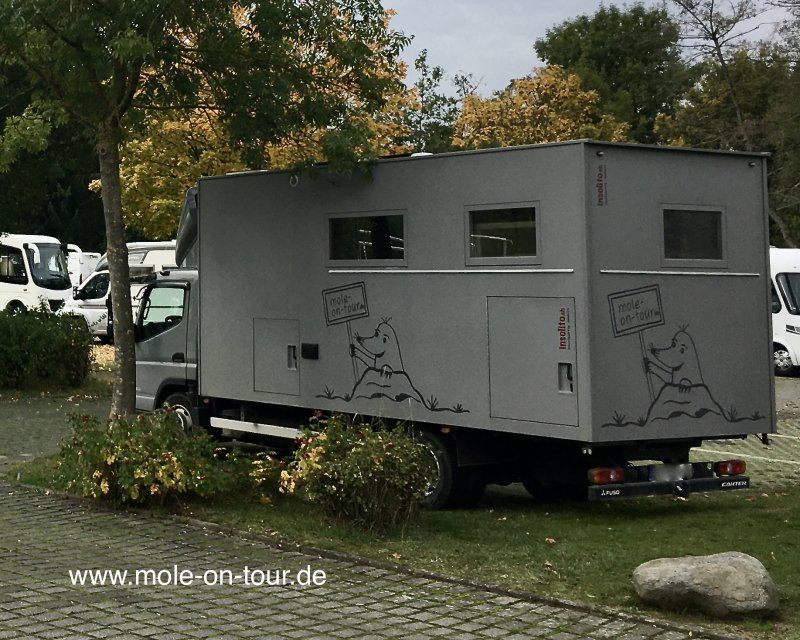
If possible, we like to go on longer tours with our mobile home.
Like e.g. in 2019 to Albania (to be read in www.mole-on-tour.de) and also reworked here in this forum.
After finding freeontour.com, we are thrilled that tours with more than 10 destinations are not limited to a maximum of 10 destinations, as is the case with all other systems (Google Maps or My Maps, as they are all called). So you can plan and dream really extensively.....
We are always happy to receive any further suggestions.
Solms, Deutschland
35606 Solms, Deutschland
50° 33' 7.1" N 8° 24' 59.4" E
50.5519629 8.4165038
• Head east on B49. Go for 9.8 km.
• Take ramp onto A45 toward Frankfurt. Go for 17.7 km.
• Take exit 35 toward Basel/Frankfurt/Wiesbaden onto A5. Go for 72.9 km.
• Take the exit toward Basel/Karlsruhe onto A5. Go for 267 km.
• Take exit 66 toward Lyon/Mulhouse/Flughafen Euro onto A5/A36. Go for 608 m.
• Continue on A36 (La Comtoise). Go for 130 km.
• Take exit 4.1 toward Besançon-Palente/Roulans/Marchaux. Go for 1.2 km.
• Continue straight ahead. Go for 40 m.
• Take the 3rd exit from roundabout toward Thise/Besançon. Go for 144 m.
• Continue on D486. Go for 11.1 km.
• Take the 1st exit from roundabout onto Rue de Belfort (D683). Go for 197 m.
• Take the 1st exit from roundabout onto Rue de Belfort (D683). Go for 809 m.
• Turn left onto Rue du Docteur Albert Schweitzer. Go for 181 m.
• Continue on Chemin du Vernois. Go for 89 m.
• Turn right onto Chemin du Vernois. Go for 722 m.
• Turn left onto Rue Bouvard. Go for 162 m.
• Turn right onto Rue de Chalezeule. Go for 370 m.
• Turn left onto Rue Jacqueline Auriol. Go for 117 m.
• Continue on Rue Jean Mermoz. Go for 10 m.
• Turn left onto Boulevard Diderot. Go for 641 m.
• Continue on Place René Payot. Go for 95 m.
• Turn left onto Place René Payot (E23) toward Pontarlier/Lausanne. Go for 346 m.
• Take the 1st exit from roundabout onto Pont Bregille (E23) toward Pontarlier/Lausanne. Go for 181 m.
• Keep right onto Rue du Général Sarrail. Go for 255 m.
• Turn left onto Rue de Pontarlier. Go for 145 m.
• Turn slightly right onto Place Jean Gigoux. Go for 121 m.
• Turn right onto Rue des Martelots. Go for 569 m.
• Turn left onto Rue de la République. Go for 44 m.
• Continue on Place du 8 Septembre. Go for 73 m.
• Arrive at Place du 8 Septembre. Your destination is on the right.
☍
515,8 km
(4 hrs. 56 min.)
Day
Aire de Camping Car, Rue d'Arènes / Rue Antide Janvier, 25000 Besançon
25000 Besançon, Frankreich
47° 14' 16.2" N 6° 1' 26.6" E
47.2378290 6.0240539
• Head toward Grande Rue on Place du 8 Septembre. Go for 14 m.
• Turn slightly left onto Grande Rue. Go for 240 m.
• Turn right onto Rue de la Préfecture. Go for 422 m.
• Turn right onto Rue Charles Nodier (D683). Go for 221 m.
• Turn left onto Boulevard Charles de Gaulle. Go for 88 m.
• Continue on Boulevard Charles de Gaulle. Go for 838 m.
• Keep left onto Rue de la Grette. Go for 138 m.
• Turn right onto Rue du Polygone. Go for 523 m.
• Turn left onto Rue de Dole (D673). Go for 986 m.
• Take the 2nd exit from roundabout onto Rue de Dole (D673). Go for 6.4 km.
• Take ramp toward A36/Chaumont/Chemaudin/Audeux/Gray. Go for 206 m.
• Take the 2nd exit from roundabout onto D67 toward A36/Chaumont/Chemaudin/Audeux/Gray/Parc d'Activités de l'Échange. Go for 2.0 km.
• Take the 2nd exit from roundabout onto D67 toward Dijon/Dole/Lyon/Strasbourg/Parc d'Activités de l'Échange. Go for 442 m.
• Take the 2nd exit from roundabout onto D67. Go for 122 m.
• Take ramp onto A36 (La Comtoise) toward Paris/Lyon/Dijon/Dole. Go for 42.3 km.
• Take the exit toward Lyon/Lons le S./Dole/Choisey onto A39 (Autoroute Verte). Go for 113 km.
• Continue on A40. Go for 2.1 km.
• Take exit 6 toward Bourg en B./St Étienne du Bois/Treffort/Cuisiat onto Échangeur de Viriat. Go for 854 m.
• Continue toward Bourg en B./Lons le S. Go for 369 m.
• Continue on Route de Meillonnas (D52 F). Go for 302 m.
• Take the 3rd exit from roundabout onto Route de Strasbourg (D1083) toward Bourg en B./Z.A. la Chambière. Go for 1.5 km.
• Pass 3 roundabouts and continue on Avenue de Bad-Kreuznach (D1083). Go for 2.7 km.
• Turn left onto Allée du Centre Nautique. Go for 152 m.
• Arrive at Allée du Centre Nautique. Your destination is on the right.
☍
175,8 km
(1 hrs. 44 min.)
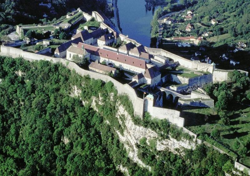
Stadtbesichtigung und Zitadelle (Weltkulturerbe)
Day
Day
Aire Comunale,5 Allée du Centre Nautique, Bourg-en-Bresse, Frankreich
5 Allée du Ctre Nautique, 01000 Bourg-en-Bresse, Frankreich
46° 12' 33.1" N 5° 14' 23.8" E
46.2091991 5.2399448
• Head east on Allée du Centre Nautique. Go for 35 m.
• Turn right. Go for 20 m.
• Turn right toward Rue du Pré Neuf. Go for 110 m.
• Turn right onto Rue du Pré Neuf. Go for 20 m.
• Turn left onto Allée du Centre Nautique. Go for 70 m.
• Turn left onto Avenue des Sports (D1083). Go for 222 m.
• Turn left onto Boulevard John Kennedy (D1075) toward Oyonnax/Genève/Lyon/Grenoble. Go for 1.3 km.
• Turn right onto Allée Loys van Boghem. Go for 195 m.
• Arrive at Allée Loys van Boghem. Your destination is on the right.
☍
2,0 km
( 4 min.)
Aire Communale, Allée Loys Van Boghem, 01000 Bourg-en-Bresse, Frankreich
Allée Loys Van Boghem, 01000 Bourg-en-Bresse, Frankreich
46° 11' 54.8" N 5° 14' 16.2" E
46.1985628 5.2378467
• Head toward Rue Marguerite d'Autriche on Allée Loys van Boghem. Go for 82 m.
• Turn slightly left onto Rue Marguerite d'Autriche. Go for 154 m.
• Turn left onto Boulevard de Brou. Go for 306 m.
• Continue on Boulevard de Brou (D1075). Go for 1.1 km.
• Take the 2nd exit from Rond-Point d'Ainterexpo roundabout onto Avenue du Maréchal Juin (D1075) toward A40/Grenoble/Genève/Oyonnax/Ambérieu en B./Pont d'Ain. Go for 1.6 km.
• Take the 3rd exit from roundabout onto Rue Charles Péguy (D1075) toward A40/Grenoble/Genève/Oyonnax/Ambérieu en B./Pont d'Ain/Montagnat. Go for 1.4 km.
• Pass 2 roundabouts and continue on D1075. Go for 2.9 km.
• Take the 3rd exit from roundabout toward E21/A40/Genève/Lyon/Aéroport Saint-Exupéry/Mâcon/Strasbourg. Go for 376 m.
• Take ramp onto A40 toward A42/Genève/Lyon/Aéroport Saint Exupéry. Go for 10.0 km.
• Continue on A42 toward Grenoble/Chambéry/Lyon/Aéroport Saint-Exupéry. Go for 48.9 km.
• Take the left exit toward Marseille/Grenoble/Lyon/N346 onto A42. Go for 990 m.
• Take the exit toward Lyon onto A42. Go for 3.6 km.
• Take the left exit toward Marseille/Grenoble/Périphérique Sud/Porte de Cusset onto D383 (Boulevard Laurent Bonnevay). Go for 6.0 km.
• Keep left onto Boulevard Laurent Bonnevay (D383) toward St Étienne/Marseille/Vénissieux. Go for 1.9 km.
• Keep left onto Boulevard Laurent Bonnevay (D383) toward Paris/Saint-Étienne/Marseille/Lyon-Centre/Vénissieux-Centre. Go for 3.3 km.
• Keep left onto D383 toward Paris/Marseille/Saint-Étienne/Pierre Bénite/Saint Fons-Centre/Port E. Herriot. Go for 2.3 km.
• Keep left onto Boulevard Pierre Sémard (D383) toward A7/Paris/Lyon/Pierre-Bénite/Marseille/St Étienne/Vénissieux/Feyzin. Go for 188 m.
• Take ramp onto A7 (Autoroute du Soleil) toward St Étienne/Feyzin/Marseille. Go for 147 km.
• Take exit 18 toward Nyons/Valréas/Pierrelatte/Viviers. Go for 683 m.
• Take the 2nd exit from roundabout onto N7 toward Nîmes/Donzère/Pierrelatte/Valréas/Nyons. Go for 2.3 km.
• Take the 4th exit from roundabout onto D133 toward Gap/Allan/Grignan/Valréas/Nyons. Go for 468 m.
• Take the 1st exit from roundabout onto D133 toward Gap/Valaurie/Grignan/Valréas/Nyons. Go for 6.2 km.
• Take the 2nd exit from roundabout onto Route de Montelimar (D541) toward Gap/Valaurie/Grignan/Valréas/Nyons. Go for 8.9 km.
• Turn left onto D4. Go for 716 m.
• Continue on Place du Jeu de Ballon. Go for 80 m.
• Continue on Rue de l'Hôpital. Go for 105 m.
• Turn right onto Place Castellane (D414). Go for 29 m.
• Turn right onto Rue de la Glacière. Go for 74 m.
• Keep right onto Place de la Glacière. Go for 48 m.
• Turn sharp right toward Rue de la Planette. Go for 95 m.
• Turn slightly right onto Rue de la Planette. Go for 43 m.
• Arrive at Rue de la Planette. Your destination is on the left.
☍
251,6 km
(2 hrs. 34 min.)
Nachmittags Stadtrundgang
Day
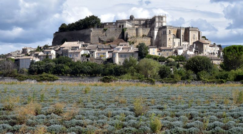
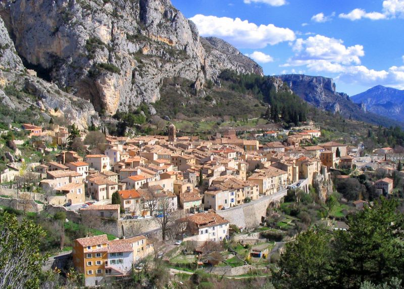
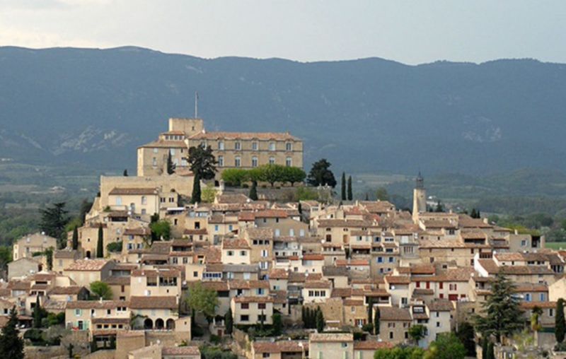
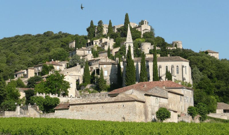
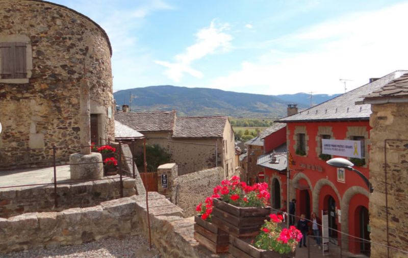
Grignan, Frankreich
Château de Grignan: famous for its letters.
The town owes its fame to its magnificent Renaissance castle and the well-known letters that Madame de Sévigné (one of the classics of French literature) wrote to her daughter , Madame de Grignan, wrote in the 17th century.
Grignan is located in the south of the Drôme department near the Ventoux mountain.
26230 Grignan, Frankreich
44° 25' 10.2" N 4° 54' 34" E
44.4195009 4.9094440
• Head toward Place de la Glacière on Rue de la Planette. Go for 138 m.
• Turn sharp left onto Place de la Glacière. Go for 48 m.
• Continue on Rue de la Glacière. Go for 74 m.
• Turn sharp right onto Avenue Chapon (D414). Go for 275 m.
• Turn right onto D541. Go for 15 m.
• Turn right onto Avenue de Grillon. Go for 84 m.
• Arrive at Avenue de Grillon. Your destination is on the left.
☍
0,6 km
( 2 min.)
Camping de GRIGNAN, Avenue de Grillon, Grignan, Frankreich
5 Avenue de Grillon, 26230 Grignan, Frankreich
44° 25' 2.5" N 4° 54' 33.3" E
44.4173582 4.9092505
• Head southeast on Avenue de Grillon. Go for 84 m.
• Turn right onto D541. Go for 545 m.
• Turn left toward Chemin de Rochecourbière. Go for 292 m.
• Turn slightly left onto Chemin de Rochecourbière. Go for 194 m.
• Arrive at Chemin de Rochecourbière. Your destination is on the right.
☍
1,1 km
( 2 min.)
Aire Camping Car, Chemin de Rochecourbière, 26230 Grignan, Frankreich
Chemin de Rochecourbière, 26230 Grignan, Frankreich
44° 24' 40.5" N 4° 54' 3.6" E
44.4112596 4.9010120
• Head north on Chemin de Rochecourbière. Go for 194 m.
• Turn slightly right toward D541. Go for 292 m.
• Turn right onto D541. Go for 3.9 km.
• Take the 1st exit from roundabout toward Grillon-Centre. Go for 61 m.
• Continue on Place de la Bourgade. Go for 158 m.
• Turn right onto Avenue du Comtat (D20) toward Richerenches/Visan. Go for 558 m.
• Continue on Route de Richerenches (D20). Go for 562 m.
• Continue on D20. Go for 2.7 km.
• Continue on Route de Grillon (D18). Go for 392 m.
• Continue on Avenue de la Rabasse (D20). Go for 611 m.
• Take the 2nd exit from roundabout onto D20 toward Visan. Go for 867 m.
• Continue on Lieu-dit Seguin (D20). Go for 141 m.
• Continue on Route de Richerenches (D20). Go for 4.3 km.
• Take the 1st exit from roundabout onto D976 toward Orange/Carpentras/Vaison la Romaine. Go for 676 m.
• Turn left onto Avenue des Alliés (D20) toward Vaison la Romaine. Go for 3.8 km.
• Turn left onto Route de Nyons (D94). Go for 980 m.
• Take the 1st exit from roundabout onto Route de Buisson (D20) toward Buisson/Vaison la Romaine. Go for 1.2 km.
• Take the 2nd exit from roundabout onto D20 toward Buisson/Vaison la Romaine. Go for 5.4 km.
• Take the 2nd exit from roundabout onto Route d'Orange (D975). Go for 2.0 km.
• Take the 2nd exit from roundabout onto Route de Roaix (D975) toward Vaison la Romaine/La Romaine. Go for 2.0 km.
• Turn right onto Avenue Alexandre Blanc. Go for 104 m.
• Turn left onto Avenue Alexandre Blanc. Go for 297 m.
• Turn right onto Avenue René Cassin. Go for 207 m.
• Take the 4th exit from roundabout onto Quai de Verdun. Go for 590 m.
• Continue on Quai Maréchal Foch. Go for 378 m.
• Continue on Route de Malaucène. Go for 1.2 km.
• Continue on Route de Malaucène (D938). Go for 1.4 km.
• Take the 2nd exit from roundabout onto Route de Malaucène (D938) toward Carpentras/Malaucène/Mont Ventoux/Le Village. Go for 5.6 km.
• Turn right onto Route de Suzette (D90) toward Suzette/Beaumes de Venise. Go for 432 m.
• Turn right. Go for 30 m.
• Arrive at your destination on the left.
☍
41,1 km
( 45 min.)
Nachmittags Rundgang im alten Stadtzentrum
Day
In die Umgebung mit dem Fahrrad
Day
Camping Le Bosquet, Route de Suzette, 84340 Malaucène, Frankreich
Route de Suzette, 84340 Malaucène, Frankreich
44° 10' 40.8" N 5° 7' 31" E
44.1780119 5.1252806
• Head toward Route de Suzette. Go for 30 m.
• Turn left onto Route de Suzette (D90). Go for 432 m.
• Turn left onto Route de Vaison (D938). Go for 2.5 km.
• Turn right onto Chemin de Carpentras à Buis les Baronnies (D13) toward Entrechaux/Buis les Baronnies/Mollans. Go for 3.6 km.
• Pass 2 roundabouts and continue on Route de Mollans (D13). Go for 3.5 km.
• Continue on Route de Carpentras (D5). Go for 1.3 km.
• Turn right onto Route de Montbrun (D40). Go for 8.9 km.
• Continue on D40. Go for 489 m.
• Continue on Rue de la Mairie (D40). Go for 116 m.
• Continue on Grande Rue (D40). Go for 190 m.
• Continue on Rue de la Mairie (D40). Go for 129 m.
• Continue on D40. Go for 1.8 km.
• Continue on Lieu-dit Le Grand Ribas (D40). Go for 79 m.
• Continue on D40. Go for 5.9 km.
• Continue on Lieu-dit Veux (D40). Go for 159 m.
• Continue on D40. Go for 2.0 km.
• Continue on D72. Go for 4.4 km.
• Turn right onto D542. Go for 10.3 km.
• Continue on Avenue de la Promenade (D164). Go for 162 m.
• Turn right onto Lieu-dit La Promenade. Go for 26 m.
• Turn left onto Place du Château. Go for 60 m.
• Continue on Place de la Croix-Blanche. Go for 17 m.
• Arrive at Place de la Croix-Blanche. Your destination is on the left.
☍
46,1 km
( 49 min.)
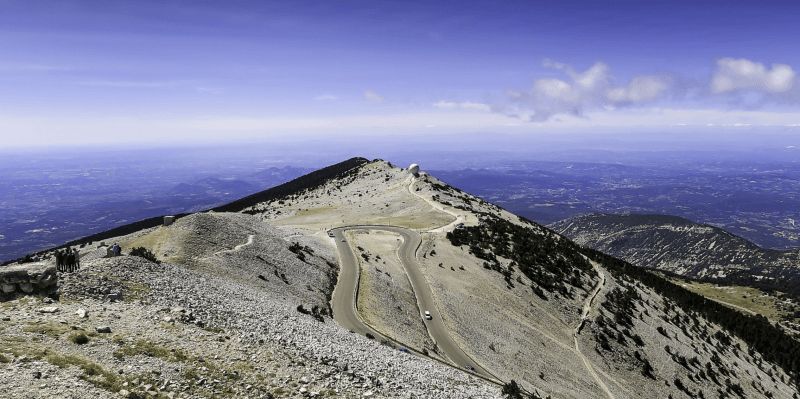
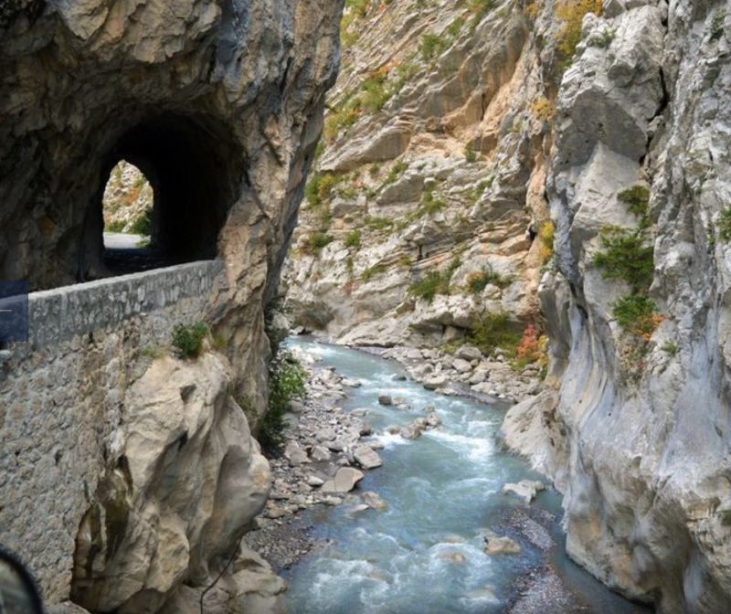
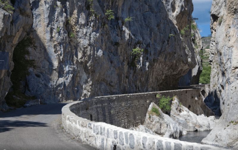
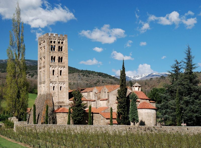
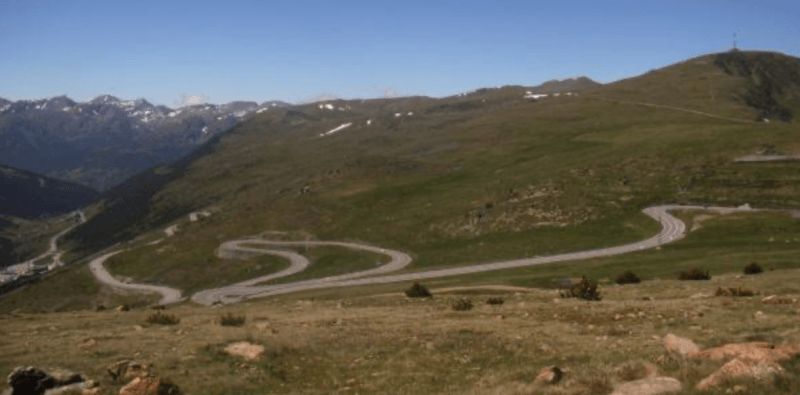
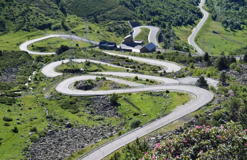
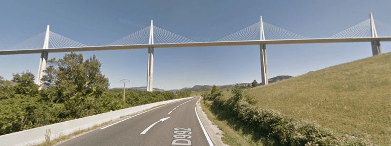
über den Pass Tempetes (Col des Tempêtes) auf dem Mont Ventoux
better known to cyclists as the "Pass of the Storms" or the Giant of Provence. The ascent is hardly difficult, the surface due to the many cycling events, mostly in perfect condition. The view and the experience of nature on the mountain are worthwhile. When the wind picks up here (the gusty Mistral blows over the bare mountain ranges), it's no longer fun.
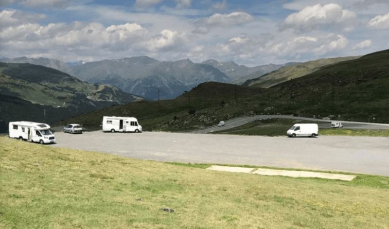
Possibly. stay at the top of the parking lot ????
(unfortunately, the route does not take planning as a waypoint - there is a winter closure / from Malaucéne the road is often closed until mid-May, , and the access road is then often only to the winter sports area on Mont Serein.)
Day
Sault, Frankreich
84390 Sault, Frankreich
44° 5' 29.1" N 5° 24' 29.4" E
44.0914130 5.4081740
• Head south on Place de la Croix-Blanche.
• Arrive at Place de la Croix-Blanche. Your destination is on the left.
☍
Distance not available
(Duration not available)
Camping Car Parking, Avenue de la Resistance, Sault, Frankreich
84390 Sault, Frankreich
44° 5' 29.1" N 5° 24' 29.4" E
44.0914130 5.4081740
• Head toward Rue du Club on Place de la Croix-Blanche. Go for 17 m.
• Turn right onto Rue du Club. Go for 35 m.
• Continue on Rue Porte des Aires. Go for 78 m.
• Continue on Avenue de l'Oratoire (D950). Go for 773 m.
• Take the 1st exit from roundabout onto Route de Saint-Trinit (D950). Go for 5.7 km.
• Turn left onto Route de Combe Chaude (D157). Go for 3.7 km.
• Continue on D63. Go for 4.9 km.
• Continue on Col de l'Homme Mort (D63). Go for 580 m.
• Continue on D63. Go for 3.3 km.
• Continue on Lieu-dit La Peyrière (D63). Go for 89 m.
• Continue on D63. Go for 517 m.
• Turn right onto D542. Go for 4.2 km.
• Turn right onto Route de Sisteron (D546). Go for 3.0 km.
• Continue on D946. Go for 30.7 km.
• Turn left onto Lieu-dit Chauffe-Piasses (D53). Go for 177 m.
• Continue on D53. Go for 710 m.
• Continue on Lieu-dit La Croix de Pierre (D53). Go for 138 m.
• Continue on D53. Go for 677 m.
• Continue on Avenue du Jabron (D53). Go for 949 m.
• Take the 3rd exit from roundabout onto Avenue du Jabron (D53). Go for 369 m.
• Continue on Avenue Jean Moulin (D53). Go for 816 m.
• Turn right onto D53. Go for 23 m.
• Turn left onto Avenue des Arcades (D53). Go for 23 m.
• Turn right onto Rue de Provence (D53). Go for 33 m.
• Take the 1st exit from roundabout onto Avenue de la Libération (D4085) toward Marseille/A51/Aix en Pce/Nice/Digne les Bains. Go for 83 m.
• Arrive at Avenue de la Libération (D4085). Your destination is on the right.
☍
61,5 km
(1 hrs. 5 min.)
Spaziergang in der Hauptstadt des Lavendel
The village of Sault is perched on a rocky outcrop in a plain made up of fields of wheat, spelled and lavender.
Only 26 km from the top of Mont Ventoux.
Day
mit dem Fahrrad in die Lavendelfelder
Day
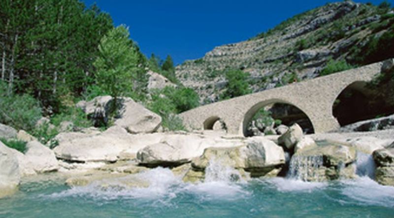
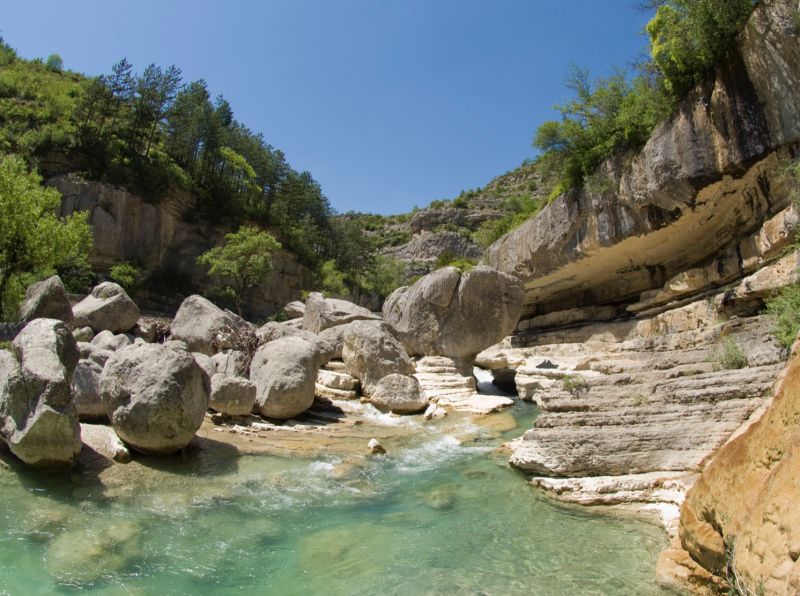
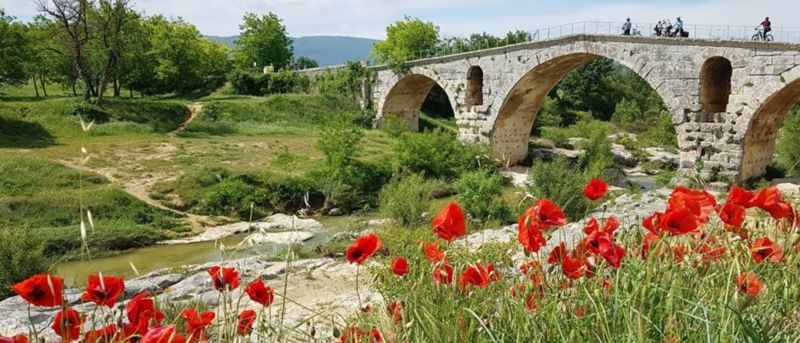
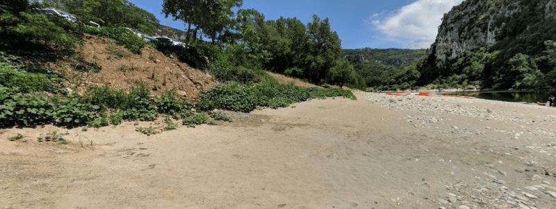
Vorbei an den Schluchten von Méouge (Gorges de la Méouge)
The Méouge gorge, described as the wonder of the Hautes-Alpes, is known for swimming and hiking. Classified as a biological reserve, it is one of the jewels of the Sisteron-Buëch area.
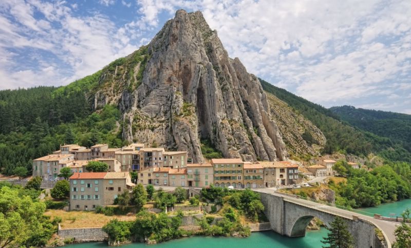
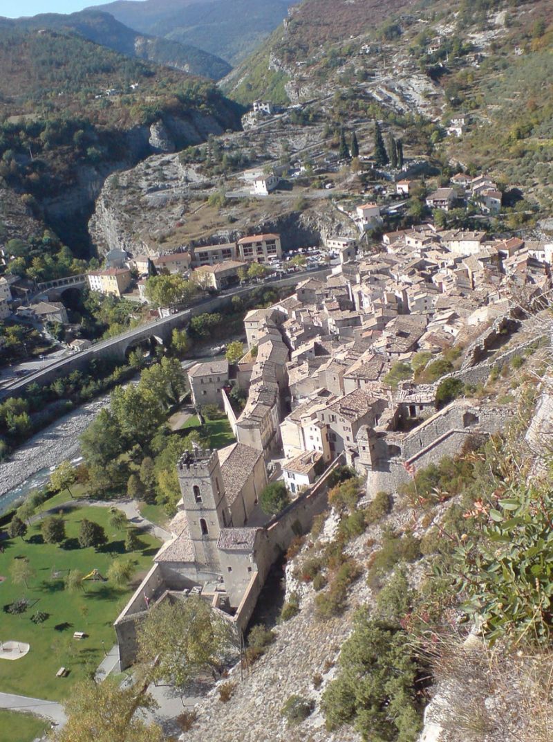
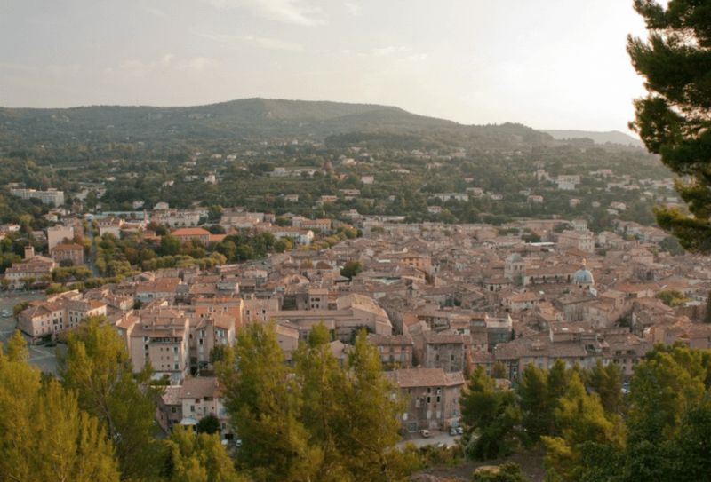
Sisteron, Frankreich
Sisteron is nicknamed "Gateway to Provence" (Porte de Provence); it is an important stop on the Napoléon route and also a frequent stage of the Tour de France.
04200 Sisteron, Frankreich
44° 11' 41" N 5° 56' 35.5" E
44.1947130 5.9431910
• Head toward Rue des Cordeliers on Avenue de la Libération (D4085). Go for 184 m.
• Turn right onto Avenue de la Libération. Go for 43 m.
• Turn left onto Avenue de la Libération (D4085). Go for 235 m.
• Take the 2nd exit from roundabout onto Avenue Paul Arène (D4085) toward Gap/A51/Grenoble. Go for 637 m.
• Arrive at Cours Melchior Donnet (D4085).
☍
1,1 km
( 2 min.)
Parking Melchior Donnet
Cours Melchior Donnet, 04200, Sisteron, Frankreich
44° 12' 0" N 5° 56' 39" E
44.2000000 5.9441667
• Head northwest on Cours Melchior Donnet (D4085). Go for 134 m.
• Take the 1st exit from roundabout onto Cours Melchior Donnet (D951) toward La Motte du Caire/Saint Geniez/La Chaumiane/La Baume. Go for 371 m.
• Turn right onto Rue du Commandant Wilmart (D4). Go for 3.2 km.
• Take the 2nd exit from roundabout onto A51 (Autoroute du Val de Durance) toward Nice/Marseille/Aix en Pce/Digne les Bains. Go for 6.4 km.
• Take exit 21 toward Digne les Bains onto N85 (Route Napoléon). Go for 5.6 km.
• Take the 2nd exit from roundabout onto Route de Nice (N85). Go for 7.1 km.
• Take the 3rd exit from roundabout onto Route Napoléon (N85) toward Digne les Bains/Nice/Mallemoisson. Go for 7.2 km.
• Take the 1st exit from roundabout onto Avenue du Général de Gaulle (N85). Go for 2.1 km.
• Pass 3 roundabouts and continue on N85. Go for 6.8 km.
• Take the 2nd exit from roundabout onto Avenue Simone Pellissier (N1085) toward Barcelonnette/Centre Ville. Go for 1.2 km.
• Take the 1st exit from Giratoire des Insurgés de 1851 roundabout onto Pont Beau de Rochas. Go for 142 m.
• Keep left onto Boulevard Gambetta. Go for 221 m.
• Take the 2nd exit from Rond-Point du 11 Novembre 1918 roundabout onto Boulevard Gassendi (D900). Go for 393 m.
• Turn right toward Traverse de la Boucherie. Go for 21 m.
• Continue on Traverse de la Boucherie. Go for 27 m.
• Turn left onto Rue de l'Hubac. Go for 67 m.
• Turn sharp right onto Montée des Prisons. Go for 85 m.
• Turn sharp left toward Rue Tour de l'Église. Go for 20 m.
• Turn slightly left onto Rue Tour de l'Église. Go for 33 m.
• Arrive at Rue Tour de l'Église. Your destination is on the right.
☍
41,1 km
( 40 min.)
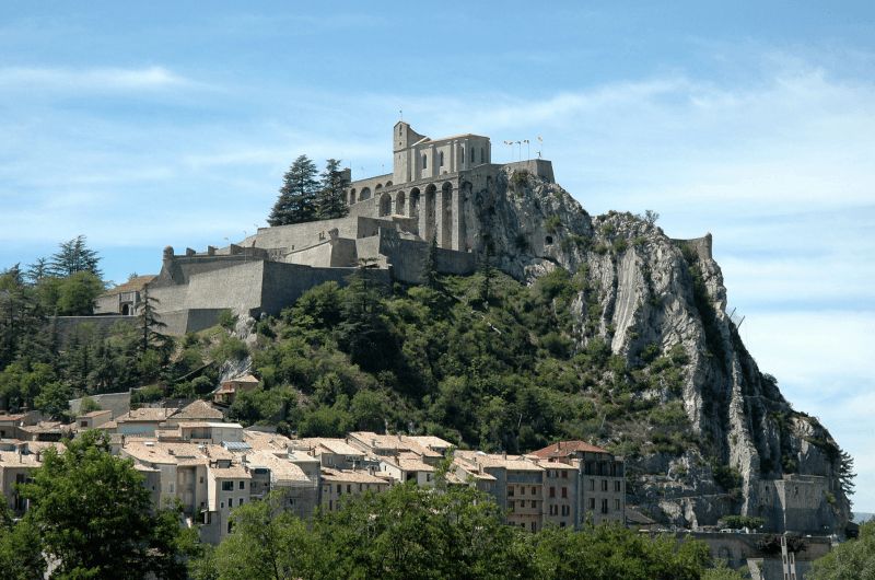
Alternativ Stellplatz: oberhalb der Zitadelle
Rundgang in der Altstadt mit Zitadelle (Etappenziel der Tour de France 2020)
Day
Fahrtstrecke ohne Digne-les-Bains
Digne-les-Bains, Frankreich
44° 5' 31.9" N 6° 14' 9.5" E
44.0921930 6.2359760
• Head west on Rue Tour de l'Église. Go for 33 m.
• Turn slightly right toward Montée des Prisons. Go for 20 m.
• Turn sharp right onto Montée des Prisons. Go for 85 m.
• Turn sharp left onto Rue de l'Hubac. Go for 67 m.
• Turn right onto Traverse de la Boucherie. Go for 48 m.
• Continue on Boulevard Gassendi (D900). Go for 31 m.
• Turn left onto Rue du Docteur Honnorat. Go for 253 m.
• Keep left onto Place du Tampinet. Go for 145 m.
• Take the 2nd exit from Rond-Point du 11 Novembre 1918 roundabout onto Grand Pont. Go for 402 m.
• Take the 2nd exit from Giratoire des Insurgés de 1851 roundabout onto Avenue Simone Pellissier (N1085). Go for 1.2 km.
• Take the 3rd exit from roundabout onto N85 toward Nice/Barrême. Go for 560 m.
• Take the 3rd exit from Rond-Point René Vieto roundabout onto Route Napoléon (N85) toward Nice/Grasse/Cannes/Barrême. Go for 8.8 km.
• Turn right toward Mézel/Riez/Moustiers St M./Châteauredon. Go for 59 m.
• Turn right onto D907. Go for 1.5 km.
• Take the 2nd exit from roundabout onto D907. Go for 12.0 km.
• Continue on D953. Go for 8.5 km.
• Turn left onto Route de Moustiers (D56). Go for 216 m.
• Continue on D56. Go for 2.4 km.
• Continue on Lieu-dit Grenouillet (D56). Go for 98 m.
• Continue on D56. Go for 2.4 km.
• Turn left onto D952. Go for 7.1 km.
• Take the 1st exit from roundabout onto D952. Go for 709 m.
• Take the 3rd exit from roundabout onto Avenue de Lérins. Go for 318 m.
• Turn right. Go for 286 m.
• Arrive at your destination on the right.
☍
47,2 km
( 51 min.)
Day
Besuch des UNESCO Géoparc de Haute-Provence - Musée Promenade BP 30156, Montée du Parc Saint-Benoît, 04990 Digne-les-Bains
mit dem Fahrrad zu den Les Clues de Barles
A clue is an almost closed passage between 2 rocks, mostly eroded by a river.
The clues de Barles were formed in a calcareous rod about 150 million years ago (late Jurassic and early Cretaceous) opened by the river Bès.
At the entrance of the gorges stands a strange stone sculpture. It is one of Andy Goldsworthy's "Guardians", modern artist, and belongs to his only Land'Art work "Refuges d'Art".
Day
evtl. nur kurzer Zwischenstopp: Moustiers-Sainte-Marie, Frankreich
The mountain village is north of the Lac de Sainte-Croix reservoir and the entrance to the Verdon Gorge.
Moustiers has been home to pottery crafts since the Middle Ages. In the 17th century the technique of faience was adopted and the town became a center of faience production, which lasted until the 19th century.
04360 Moustiers-Sainte-Marie, Frankreich
43° 50' 44.5" N 6° 13' 17.3" E
43.8456819 6.2214810
• Head toward Rue de la Bourgade. Go for 30 m.
• Turn sharp left onto Avenue de Lérins. Go for 63 m.
• Turn right onto Chemin de la Maladrerie. Go for 322 m.
• Turn slightly right. Go for 23 m.
• Turn right. Go for 66 m.
• Arrive at your destination on the left.
☍
0,5 km
( 1 min.)
Aire Camping Car Parking Prola
Chemin de Quinson, 04360, Moustiers Sainte-Marie, Frankreich
43° 50' 37" N 6° 13' 7" E
43.8436111 6.2186111
• Head toward Chemin de Quinson. Go for 66 m.
• Turn left toward D952. Go for 23 m.
• Turn right onto D952. Go for 291 m.
• Take the 1st exit from roundabout onto Route de la Palud (D952). Go for 1.9 km.
• Take the 2nd exit from roundabout onto D957. Go for 4.8 km.
• Arrive at D957. Your destination is on the left.
☍
7,1 km
( 8 min.)
Rundgang in Moustiers-Saint-Marie
Day
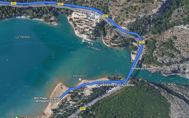
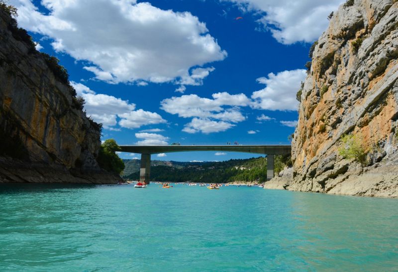
Pont du Galetas, D957, 83630 Aiguines, Frankreich
D957, 83630 Aiguines, Frankreich
43° 48' 5.7" N 6° 14' 58" E
43.8015827 6.2494548
• Head southwest on D957. Go for 55 m.
• Turn right. Go for 105 m.
• Arrive at your destination on the left.
☍
0,2 km
( )
Parking Pont du Galetas, 83630 Aiguines, Frankreich
Unnamed Road, 83630 Aiguines, Frankreich
43° 48' 3.3" N 6° 14' 52.1" E
43.8009221 6.2478002
• Head east. Go for 105 m.
• Turn right onto D957. Go for 4.6 km.
• Arrive at D957. Your destination is on the left.
☍
4,7 km
( 4 min.)
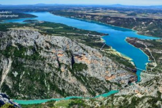
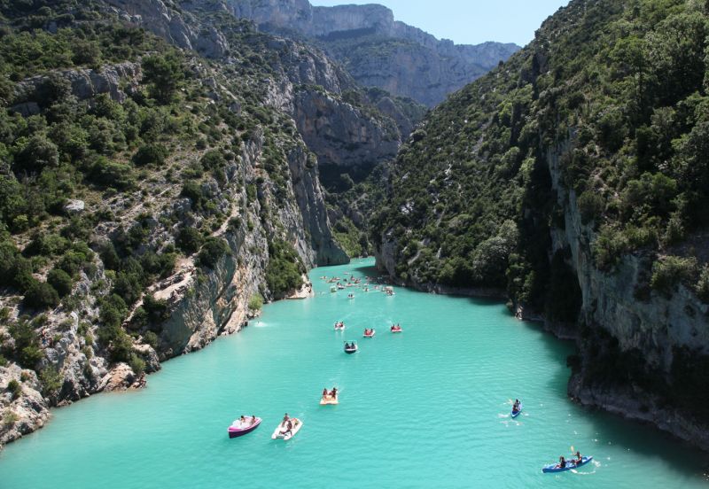
mit dem Tretboot in die Verdon-Schlucht
Verdon Stellplatz, 83630 Les Salles-sur-Verdon, Frankreich
CD 957 route de Moustiers, 83630 Les Salles-sur-Verdon, Frankreich
43° 46' 39.6" N 6° 12' 50.1" E
43.7776799 6.2139127
• Head northwest on D957. Go for 9.4 km.
• Take the 2nd exit from roundabout onto Route de la Palud (D952). Go for 2.0 km.
• Take the 2nd exit from roundabout onto Avenue de Lérins. Go for 290 m.
• Turn right. Go for 157 m.
• Turn right. Go for 237 m.
• Turn right toward Lieu-dit Saint-Maurin. Go for 9.0 km.
• Continue on Lieu-dit Saint-Maurin. Go for 2.6 km.
• Turn right onto Lieu-dit Les Ferrailles. Go for 1.2 km.
• Turn left. Go for 2.2 km.
• Continue toward D123. Go for 81 m.
• Turn slightly right onto D123. Go for 1.2 km.
• Continue on Lieu-dit Le Brec (D123). Go for 76 m.
• Continue on Lieu-dit Coni (D123). Go for 333 m.
• Turn slightly left onto Lieu-dit Le Vignal. Go for 271 m.
• Continue toward Lieu-dit Le Village la Palud. Go for 92 m.
• Turn slightly left onto Lieu-dit Le Village la Palud. Go for 9 m.
• Continue on Lieu-dit Le Village la Palud. Go for 187 m.
• Turn slightly right onto Lieu-dit Le Village la Palud. Go for 124 m.
• Turn right onto Lieu-dit Le Village la Palud. Go for 76 m.
• Arrive at Lieu-dit Le Village la Palud. Your destination is on the left.
☍
29,6 km
( 59 min.)
Day
04120 La Palud-sur-Verdon, Frankreich
43° 46' 46.2" N 6° 20' 30.6" E
43.7794979 6.3418440
• Head southeast on Lieu-dit Le Village la Palud. Go for 76 m.
• Turn left onto Lieu-dit Le Village la Palud. Go for 320 m.
• Turn right onto Lieu-dit Le Vignaou (D952). Go for 7.2 km.
• Take the 2nd exit from roundabout onto D952. Go for 5.6 km.
• Turn left onto Lieu-dit Pont de Soleils (D952). Go for 11.9 km.
• Take the 2nd exit from roundabout onto Rue Nationale (D4085) toward Digne/Grenoble/Barrême/St André. Go for 766 m.
• Take the 2nd exit from roundabout onto D955 toward St André les Alpes/Annot/St Julien du Verdon/Lac de Castillon. Go for 12.3 km.
• Turn left onto N202. Go for 401 m.
• Turn left onto Montée des Chênes. Go for 50 m.
• Arrive at Montée des Chênes. Your destination is on the right.
☍
38,6 km
( 49 min.)
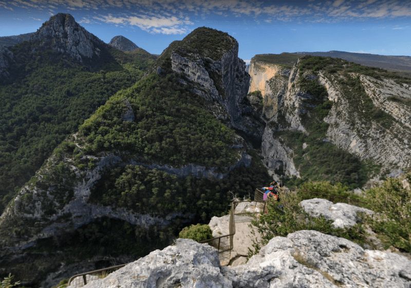
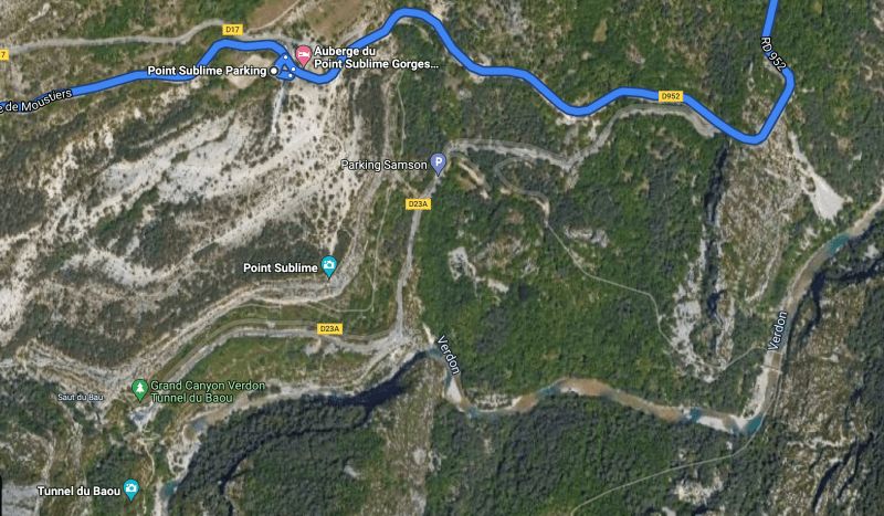
Fahrt entlang der Verdon-Schlucht - Stopp am Point Sublime - weiter über Castellane
The Point Sublime is one of the most beautiful vantage points of the Verdon Gorges. It is located on the right bank of the river.
Camping du lac Saint-Julien du Verdon, Les Clots, Saint-Julien-du-Verdon, Frankreich
Les Clots, 04170 Saint-Julien-du-Verdon, Frankreich
43° 54' 58.3" N 6° 32' 25.4" E
43.9162007 6.5403862
• Head east on Montée des Chênes. Go for 50 m.
• Turn right onto N202. Go for 17.2 km.
• Turn right onto N202 toward Nice/Entrevaux. Go for 6.6 km.
• Continue on Route de Nice (D4202) toward Nice/Entrevaux. Go for 5.5 km.
• Arrive at Avenue Vauban (D4202). Your destination is on the left.
☍
29,3 km
( 29 min.)
Faulenzen am Lac de Castillon
Day
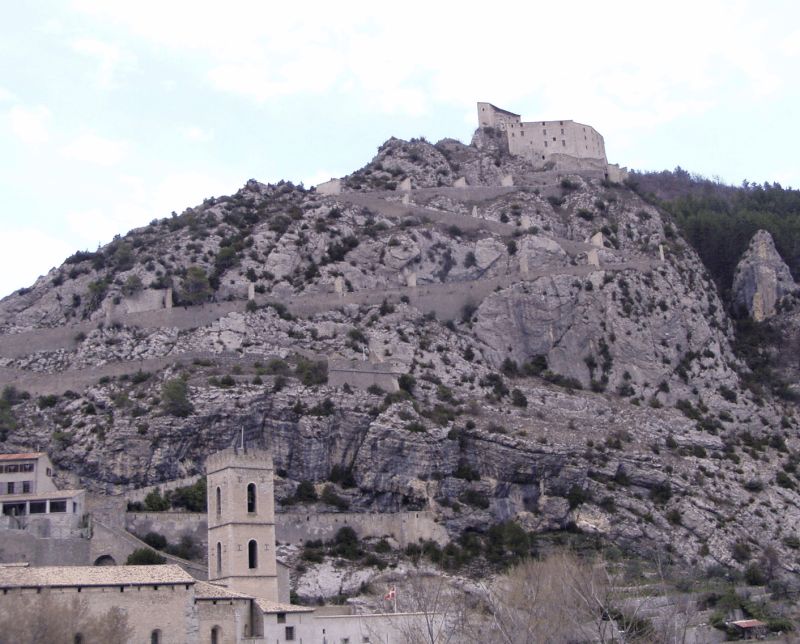
Entrevaux, Frankreich
An exceptional medieval setting with access to the fortified city walls via a stone bridge.
04320 Entrevaux, Frankreich
43° 57' 0.9" N 6° 48' 36.2" E
43.9502420 6.8100420
• Head southeast on Avenue Vauban (D4202). Go for 242 m.
• Turn right onto Avenue Vauban. Go for 112 m.
• Turn left toward Lieu-dit Le Vieux Chemin. Go for 9 m.
• Turn left onto Lieu-dit Le Vieux Chemin. Go for 193 m.
• Arrive at Lieu-dit Le Vieux Chemin. Your destination is on the right.
☍
0,6 km
( 1 min.)
Aire Camping Car, Entrevaux - Parking de la gare, La Gare, 04320 Entrevaux, Frankreich
La Gare, 04320 Entrevaux, Frankreich
43° 56' 56.1" N 6° 48' 51.2" E
43.9489097 6.8142318
• Head west on Lieu-dit Le Vieux Chemin. Go for 193 m.
• Turn right toward Avenue Vauban. Go for 9 m.
• Turn right onto Avenue Vauban. Go for 112 m.
• Turn right onto Avenue Vauban (D4202). Go for 5.1 km.
• Continue on D6202. Go for 9.7 km.
• Take the 1st exit from roundabout onto D6202. Go for 18.6 km.
• Take ramp onto Tunnel de la Mescla (D6102) toward Nice/St Martin du Var. Go for 2.7 km.
• Keep right onto M6102. Go for 5.0 km.
• Continue on Route de Grenoble (M6202). Go for 740 m.
• Pass 10 roundabouts and continue on Boulevard du Mercantour (M6202). Go for 16.9 km.
• Keep left onto Boulevard du Mercantour (M6202) toward Nice-Nord/Monaco/Gênes. Go for 95 m.
• Take the 3rd exit from roundabout onto A8 (La Provençale) toward Gênes/Monaco/Nice-Nord. Go for 17.4 km.
• Take exit 56 toward Monaco/Beausoleil/Cap d'Ail onto A500. Go for 2.9 km.
• Continue on M6007. Go for 134 m.
• Continue on Route de la Moyenne Corniche (D6007). Go for 2.9 km.
• Take the 1st exit from roundabout onto Boulevard du Jardin Exotique (M6307). Go for 274 m.
• Continue on Boulevard du Jardin Exotique. Go for 41 m.
• Keep left onto Boulevard du Jardin Exotique. Go for 7 m.
• Turn right onto Tunnel Albert II. Go for 98 m.
• Continue on Tunnel Albert II. Go for 1.5 km.
• Continue on Tunnel Albert II. Go for 294 m.
• Continue on Boulevard Charles III. Go for 61 m.
• Take the 3rd exit from roundabout onto Boulevard Charles III. Go for 105 m.
• Turn right onto Boulevard Charles III. Go for 440 m.
• Take the 1st exit from Place du Canton roundabout onto Boulevard Charles III. Go for 181 m.
• Take the 1st exit from roundabout onto Avenue de la Porte Neuve. Go for 637 m.
• Turn slightly right toward Avenue Saint-Martin. Go for 34 m.
• Continue on Avenue Saint-Martin. Go for 85 m.
• Turn slightly right onto Avenue des Pins. Go for 136 m.
• Turn right onto Rue Princesse Marie de Lorraine. Go for 129 m.
• Turn right onto Rue Philibert Florence. Go for 57 m.
• Turn left onto Rue des Remparts. Go for 217 m.
• Turn left onto Place du Palais. Go for 81 m.
• Turn left onto Place du Palais. Go for 13 m.
• Continue on Rue Colonel Bellando de Castro. Go for 107 m.
• Turn left onto Allée Jean Paul II. Go for 64 m.
• Arrive at Allée Jean Paul II. Your destination is on the right.
☍
87,1 km
(1 hrs. 16 min.)
Day
Monaco City, Monaco-Ville, Monaco
Monaco-Ville, Monaco
43° 43' 50.9" N 7° 25' 21.3" E
43.7308084 7.4225881
• Head toward Place Saint-Nicolas on Allée Jean Paul II. Go for 64 m.
• Turn left onto Avenue Saint-Martin. Go for 583 m.
• Turn slightly left onto Avenue de la Porte Neuve. Go for 576 m.
• Continue on Avenue de la Porte Neuve. Go for 54 m.
• Take the 2nd exit from roundabout onto Avenue Prince Pierre. Go for 97 m.
• Turn left onto Rue de la Colle. Go for 25 m.
• Arrive at Rue de la Colle. Your destination is on the right.
☍
1,4 km
( 3 min.)
Starbucks Coffee, Les Jardins d'Apolline, 12 Rue de la Colle, 98000 Monaco-Ville, Monaco
Les Jardins d'Apolline, 12 Rue de la Colle, 98000 Monaco
43° 43' 57.3" N 7° 25' 3.9" E
43.7325932 7.4177514
• Head toward Rue du Rocher on Rue de la Colle. Go for 86 m.
• Keep right onto Rue de la Colle toward Nice/Cap d'Ail/Hôpital. Go for 24 m.
• Take the 2nd exit from Place du Canton roundabout onto Tunnel Pasteur. Go for 313 m.
• Continue on Boulevard Rainier III. Go for 11 m.
• Continue on Tunnel Millenium. Go for 91 m.
• Continue on Boulevard Rainier III. Go for 73 m.
• Continue on Boulevard Charles III. Go for 72 m.
• Take the 1st exit from roundabout onto Boulevard Charles III. Go for 67 m.
• Continue on Boulevard Charles III. Go for 7 m.
• Take the 1st exit from roundabout onto Avenue du Trois Septembre (M6098). Go for 1.1 km.
• Take the 1st exit from roundabout onto Avenue du Trois Septembre (M6098). Go for 766 m.
• Turn right onto Place Baverbrook. Go for 12 m.
• Arrive at Place Baverbrook. Your destination is on the left.
☍
2,6 km
( 5 min.)
Parking Beaverbrook, 5 Avenue du Général de Gaulle, 06320 Cap-d'Ail, Frankreich
5 Avenue du Général de Gaulle, 06320 Cap-d'Ail, Frankreich
43° 43' 23.4" N 7° 23' 45.6" E
43.7231788 7.3960137
• Head toward Allée des Orangers on Place Baverbrook. Go for 61 m.
• Turn right onto Avenue du Trois Septembre (M6098). Go for 25 m.
• Take the 1st exit from roundabout onto Avenue Général de Gaulle (M37). Go for 1.3 km.
• Turn sharp left onto Route de la Moyenne Corniche (M6007). Go for 1.9 km.
• Continue on M6007. Go for 153 m.
• Keep left toward A500/A8/La Turbie/Nice/Toulon/Marseille. Go for 133 m.
• Continue on Tunnel de Monaco. Go for 2.4 km.
• Take ramp onto A8 (La Provençale). Go for 22.2 km.
• Take exit 49 toward St Laurent du Var/A8 (Nice)/Gare SNCF. Go for 233 m.
• Take the 1st exit from Rond-Point Georges Pompidou roundabout onto Boulevard Georges Pompidou (M95) toward Gare SNCF. Go for 195 m.
• Take the 2nd exit from Rond-Point Maïcon roundabout toward St Laurent-la Gare. Go for 141 m.
• Take the 2nd exit from roundabout onto Avenue Léonard Arnaud. Go for 171 m.
• Turn right onto Avenue Émile Dechame. Go for 88 m.
• Turn right onto Avenue Émile Dechame. Go for 39 m.
• Arrive at Avenue Émile Dechame.
☍
29,0 km
( 23 min.)
Arie Camping Car, Av. Emile Dechame, 06700 Saint-Laurent-du-Var, Frankreich
Av. Emile Dechame, 06700 Saint-Laurent-du-Var, Frankreich
43° 39' 58.2" N 7° 11' 39.7" E
43.6661751 7.1943736
• Head toward Allée des Studios on Avenue Émile Dechame. Go for 106 m.
• Continue on Avenue Francis Teisseire. Go for 93 m.
• Take the 3rd exit from roundabout. Go for 117 m.
• Take the 2nd exit from Rond-Point Maïcon roundabout onto Boulevard Georges Pompidou (M95) toward Antibes/Cannes/Carros/St Laurent-Centre. Go for 244 m.
• Take the 2nd exit from Rond-Point Georges Pompidou roundabout onto A8 (La Provençale) toward Antibes/Cannes. Go for 20.2 km.
• Take exit 42 toward Grasse/Mougins. Go for 695 m.
• Take the 3rd exit from Rond-Point de la Libération roundabout onto Pénétrante Cannes Grasse (D6185) toward Grasse/Mougins/Mouans-Sartoux/Valbonne/Sophia-Antipolis. Go for 10.4 km.
• Take the 2nd exit from Lieu-dit L'Alambic roundabout onto Route de Pégomas (D9) toward Les Aspres/Hôpital Clinique du Palais. Go for 603 m.
• Take the 5th exit from Rond-Point des 4 Chemins roundabout onto Avenue Georges Pompidou (N85) toward Draguignan/Digne/Route Napoléon. Go for 1.2 km.
• Arrive at Avenue du Maréchal de Lattre de Tassigny (N85).
☍
33,6 km
( 24 min.)
Day
Route Napoléon, 06130 Grasse, Frankreich
43° 38' 55.2" N 6° 55' 51.9" E
43.6486788 6.9310820
• Head toward Avenue de l'Oliveraie on Avenue du Maréchal de Lattre de Tassigny (N85). Go for 160 m.
• Turn left onto Avenue du Maréchal de Lattre de Tassigny. Go for 55 m.
• Turn right toward Avenue du Maréchal de Lattre de Tassigny. Go for 104 m.
• Turn left onto Avenue du Maréchal de Lattre de Tassigny. Go for 55 m.
• Turn right onto Avenue du Maréchal de Lattre de Tassigny (N85). Go for 1.2 km.
• Take the 1st exit from Rond-Point des 4 Chemins roundabout onto Route de Pégomas (D9) toward A8/Cannes/Antibes. Go for 533 m.
• Take the 1st exit from Lieu-dit L'Alambic roundabout onto Pénétrante Cannes Grasse (D6185) toward A8/Cannes/Antibes. Go for 10.0 km.
• Take ramp onto A8 (La Provençale) toward Toulon. Go for 146 km.
• Take exit 30 toward Aix-Centre/Aix-Pont de l'Arc onto D8 N (Avenue Pierre Brossolette). Go for 484 m.
• Pass 2 roundabouts and continue on Avenue des Belges (D8 N). Go for 1.6 km.
• Turn left onto Place du Général de Gaulle (D7 N). Go for 44 m.
• Turn left onto Avenue Napoléon Bonaparte (D7 N). Go for 152 m.
• Turn right onto Place Paul Ferréol. Go for 30 m.
• Continue on Rue Lisse des Cordeliers. Go for 253 m.
• Continue on Rue de la Treille. Go for 31 m.
• Turn right onto Rue des Muletiers. Go for 78 m.
• Continue on Rue des Cardeurs. Go for 49 m.
• Arrive at Rue des Cardeurs.
☍
161,3 km
(1 hrs. 28 min.)
Nachmittags in die Parfumstadt
Day
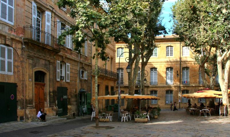
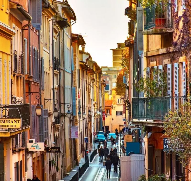
Aix-en-Provence, Frankreich
The city was the birthplace of the post-impressionist painter Paul Cézanne. Today, a tour takes you past various stations in his life, including his childhood home.
The climate is Mediterranean with hot, dry summers and mild, sunny winters. The hills to the north (Luberon and Trévaresse) offer some protection from the dreaded mistral. The mean temperature varies between 6.5 °C in January and 24 °C in July.
43° 31' 47.1" N 5° 26' 50.7" E
43.5297420 5.4474270
• Head east on Rue des Cardeurs.
• Turn left onto Rue du Cancel. Go for 116 m.
• Turn left onto Rue du Bon-Pasteur. Go for 25 m.
• Turn right onto Rue des Étuves. Go for 103 m.
• Turn right onto Rue des Étuves. Go for 86 m.
• Continue on Rue des Guerriers. Go for 22 m.
• Turn slightly left toward Boulevard Jean Jaurès/D10. Go for 35 m.
• Turn left onto Boulevard Jean Jaurès (D10). Go for 601 m.
• Turn left onto Avenue Maréchal de Lattre de Tassigny (D10). Go for 182 m.
• Continue on Rue de l'Entrepôt. Go for 142 m.
• Continue on Avenue Georges Pompidou. Go for 138 m.
• Take the 1st exit from Rond-Point François Turpin roundabout onto Avenue Max Juvenal. Go for 371 m.
• Continue on Avenue Henri Mouret. Go for 630 m.
• Continue toward Rond-Point Raimond-Bérenger V. Go for 36 m.
• Take ramp onto A51 toward Marseille/Aéroport Marignane/Fos/Martigues/Les Milles/Gardanne. Go for 15.8 km.
• Take the exit toward Fos/Martigues/Aéroport Marignane/L'Estaque onto A7 (Autoroute du Soleil). Go for 4.1 km.
• Take the exit toward Fos/Martigues/Marseille-l'Estaque onto A55. Go for 10.8 km.
• Take the exit toward Châteauneuf-les-M./Carry-le-Rouet/Carry le Rouet/Châteauneuf les Martigues onto D9. Go for 13.9 km.
• Take ramp. Go for 377 m.
• Turn left onto Route de la Couronne (D49). Go for 751 m.
• Continue on Rue Olivier Griscelli (D49). Go for 19 m.
• Take the 2nd exit from roundabout onto Rue de la Bergerie. Go for 218 m.
• Turn right onto Chemin de la Batterie. Go for 258 m.
• Arrive at Chemin de la Batterie. Your destination is on the left.
☍
48,8 km
( 35 min.)
Day
Day
La Couronne, Martigues, Frankreich
The village is located on the Mediterranean Sea, on the Côte Bleue.
It is best known for its old quarries and lighthouses. The quarries were already mentioned by the Greek Strabo. Excavations suggest that they were used as early as the 6th century BC.
The Cap Couronne is the most prominent headland between the Bay of Marseille and that of Fos-sur-Mer.
La Couronne, 13500 Martigues, Frankreich
43° 20' 12.1" N 5° 3' 23.2" E
43.3366980 5.0564433
• Head toward Chemin du Roucau on Chemin de la Batterie. Go for 258 m.
• Turn left onto Rue de la Bergerie. Go for 168 m.
• Take the 2nd exit from roundabout onto Rue Olivier Griscelli (D49). Go for 55 m.
• Continue on Route de Martigues (D49). Go for 5.0 km.
• Continue on D5. Go for 2.5 km.
• Take the 2nd exit from roundabout onto Route de Saint-Pierre (D5). Go for 548 m.
• Turn right onto Boulevard Marcel Cachin (D5) toward Centre Ville. Go for 795 m.
• Turn sharp left onto Avenue Frédéric Mistral (N568). Go for 245 m.
• Keep right onto Quai Général Leclerc (N568). Go for 416 m.
• Continue on Pont Levant (N568). Go for 99 m.
• Continue on Quai Jean-Baptiste Kléber (N568). Go for 180 m.
• Take the 1st exit from roundabout onto N568. Go for 76 m.
• Continue on Quai Maurice Tesse. Go for 95 m.
• Continue on Rue du Colonel Fabien. Go for 122 m.
• Continue on Avenue Salvador Allende. Go for 927 m.
• Take the 1st exit from roundabout onto Avenue du Docteur Fleming. Go for 1.8 km.
• Pass 7 roundabouts and continue on D5. Go for 8.4 km.
• Take the 2nd exit from roundabout onto Avenue Félix Gouin (D5). Go for 471 m.
• Pass 4 roundabouts and continue on Avenue Félix Gouin (D569 N). Go for 2.1 km.
• Take the 1st exit from roundabout onto Boulevard de Vauranne. Go for 481 m.
• Continue on Boulevard Jean-Marie l'Huillier. Go for 358 m.
• Turn right onto Avenue Aristide Briand. Go for 108 m.
• Turn right onto Boulevard de la République. Go for 110 m.
• Turn left onto Place Docteur Georges Darrason. Go for 16 m.
• Continue on Rue Alphonse Daudet. Go for 19 m.
• Arrive at Rue Alphonse Daudet. Your destination is on the left.
☍
25,5 km
( 29 min.)
Day
Day
Istres, Frankreich
43° 30' 46.8" N 4° 59' 16.7" E
43.5130060 4.9879680
• Head northeast on Rue Alphonse Daudet.
• Turn left onto Rue Justin Beaucaire. Go for 115 m.
• Continue on Place José Coto. Go for 10 m.
• Turn left onto Rue du Puits-Neuf. Go for 6 m.
• Turn right onto Rue Juiverie. Go for 98 m.
• Continue on Place de la Porte d'Arles. Go for 13 m.
• Turn left onto Place de la Porte d'Arles. Go for 21 m.
• Continue on Avenue Jean Lebas. Go for 76 m.
• Continue on Avenue Adam de Craponne. Go for 387 m.
• Pass 4 roundabouts and continue on D569 N. Go for 7.1 km.
• Take the 2nd exit from roundabout. Go for 819 m.
• Take the 1st exit from roundabout onto Lieu-dit La Transhumance (N569). Go for 1.5 km.
• Take the 2nd exit from roundabout onto N569 toward A54/Salon de Provence/Eyguières/Grans/Miramas-Molières. Go for 3.0 km.
• Take the 2nd exit from roundabout onto D69 toward Salon/Grans. Go for 6.3 km.
• Take the 3rd exit from roundabout onto D69 toward Avignon/Aix en Provence/Arles/Salon-Centre. Go for 86 m.
• Pass 2 roundabouts and continue on Avenue Louis Pasteur (D69). Go for 739 m.
• Continue on Rue Désiré Alleman. Go for 303 m.
• Turn left onto Boulevard Danton. Go for 202 m.
• Take the 2nd exit from Avenue Michelet roundabout onto Boulevard Roger Carcassonne (N572). Go for 721 m.
• Continue on Place Eugène Pelletan. Go for 176 m.
• Continue on Cours Victor Hugo. Go for 242 m.
• Continue on Cours Gimon. Go for 238 m.
• Turn right onto Montée du Puech. Go for 46 m.
• Turn left onto Place Catherine de Médicis. Go for 76 m.
• Continue on Montée du Peuch. Go for 133 m.
• Continue on Place Farreyroux. Go for 40 m.
• Arrive at Place Farreyroux. Your destination is on the left.
☍
22,4 km
( 26 min.)
Salon-de-Provence, Frankreich
43° 38' 24.7" N 5° 5' 49.3" E
43.6401990 5.0970220
• Head toward Rue de l'Emperi on Place Farreyroux. Go for 40 m.
• Continue on Montée du Peuch. Go for 133 m.
• Continue on Place Catherine de Médicis. Go for 76 m.
• Turn right onto Montée du Puech. Go for 46 m.
• Turn right onto Cours Gimon. Go for 48 m.
• Continue on Allées de Craponne. Go for 73 m.
• Take the 2nd exit from roundabout onto Rue Janicot. Go for 17 m.
• Turn left onto Boulevard des Capucins (N538). Go for 307 m.
• Turn slightly left onto Boulevard Lamartine (N538). Go for 156 m.
• Take the 1st exit from roundabout onto Place Portail Coucou (N538). Go for 26 m.
• Continue on Boulevard David (N538). Go for 417 m.
• Turn right onto Boulevard David (N538). Go for 428 m.
• Continue on Avenue Jean Moulin (N538). Go for 226 m.
• Take the 2nd exit from Rond-Point René Cassin roundabout onto Avenue Jean Moulin (N538) toward A54 (Lyon)/Avignon/Sénas/Lamanon. Go for 731 m.
• Take the 3rd exit from roundabout onto Route Jean Moulin (D538) toward Les Canourgues. Go for 5.3 km.
• Take the 2nd exit from roundabout onto Route d'Alleins (D17 D) toward Alleins/Mallemort. Go for 1.9 km.
• Continue on Chemin de Craponne (D23) toward Mallemort. Go for 1.3 km.
• Continue on Route du Pont de Cadarache (D23). Go for 2.3 km.
• Continue on Route de Mallemort (D23). Go for 763 m.
• Take the 2nd exit from roundabout onto D23 toward Mallemort/Mérindol/Pertuis. Go for 91 m.
• Continue on Lieu-dit Dounneau (D23). Go for 104 m.
• Continue on D23. Go for 1.0 km.
• Take the 3rd exit from roundabout onto D23. Go for 433 m.
• Continue on D32. Go for 983 m.
• Continue on Lieu-dit La Gare (D32). Go for 113 m.
• Continue on D32. Go for 932 m.
• Take the 2nd exit from roundabout onto D973. Go for 1.7 km.
• Pass 3 roundabouts and continue on D973. Go for 14.4 km.
• Take the 3rd exit from roundabout onto D973 toward Pertuis. Go for 1.9 km.
• Turn left onto D973 toward Cavaillon/Lauris/Apt. Go for 282 m.
• Turn right onto Route de Pertuis (D973). Go for 2.3 km.
• Continue on Route de Cadenet (D973). Go for 199 m.
• Continue on Route de Cadenet. Go for 329 m.
• Take the 3rd exit from roundabout onto Route d'Ansouis (D37). Go for 1.4 km.
• Continue on Route de la Gare de Villelaure à Ansouis (D37). Go for 551 m.
• Continue on Lieu-dit La Tour de Ferrier (D37). Go for 121 m.
• Turn right onto D37. Go for 926 m.
• Turn left onto Route de la Fosse de Gastoul (D37). Go for 1.6 km.
• Turn right onto Rue de France. Go for 157 m.
• Turn slightly left onto Grande Rue. Go for 136 m.
• Continue on Rue du Petit Portail. Go for 8 m.
• Arrive at Rue du Petit Portail. Your destination is on the right.
☍
44,0 km
( 40 min.)
Day
Day
Ansouis, Frankreich
It has been classified as one of the Plus beaux villages de France (Most Beautiful Villages in France).
The château, former residence of the Sabran family (10th century). Originally built as a castle, remodeled in the 12th and 13th centuries, further remodeling in the 15th and 19th centuries. The current building dates from the 17th century and has two small garden parterres in baroque style.
43° 44' 16.5" N 5° 27' 49.8" E
43.7379300 5.4638340
• Head toward Place du Château on Rue du Petit Portail. Go for 8 m.
• Continue on Grande Rue. Go for 136 m.
• Turn slightly right onto Rue de France. Go for 157 m.
• Turn right onto Route de Pertuis à Cucuron (D56). Go for 110 m.
• Take the 2nd exit from roundabout onto Route du Pertuis à Cucuron (D56). Go for 38 m.
• Continue on D37. Go for 335 m.
• Continue on Lieu-dit La Pousterle (D37). Go for 129 m.
• Continue on D37. Go for 435 m.
• Continue on Route de la Gare de Villelaure (D37). Go for 1.6 km.
• Continue on Route de Vaugines à Mirabeau (D135) toward La Tour-d'Aigues. Go for 1.5 km.
• Continue on Route de Pertuis à la Vallèe d'Aigues (D9) toward La Tour-d'Aigues/Pertuis. Go for 610 m.
• Turn left onto D135. Go for 50 m.
• Turn left onto Chemin des Hautes Terres. Go for 760 m.
• Turn left onto Chemin des Hautes Terres. Go for 96 m.
• Arrive at Chemin des Hautes Terres. Your destination is on the right.
☍
5,9 km
( 7 min.)
L'Art Glacier, Chemin des Hautes Terres, 84240 Ansouis, Frankreich
767 Chemin des Hautes Terres, 84240 Ansouis, Frankreich
43° 44' 33.8" N 5° 30' 35.6" E
43.7427359 5.5098822
• Head east on Chemin des Hautes Terres. Go for 96 m.
• Turn right onto Chemin des Hautes Terres. Go for 760 m.
• Turn right onto D135. Go for 50 m.
• Turn right onto Route de Pertuis à la Vallèe d'Aigues (D9). Go for 610 m.
• Turn left onto Route de Vaugines à Mirabeau (D135) toward Ansouis. Go for 1.5 km.
• Continue on Route de la Gare de Villelaure (D37) toward Ansouis. Go for 1.6 km.
• Continue on D37. Go for 435 m.
• Continue on Lieu-dit La Pousterle (D37). Go for 129 m.
• Continue on D37. Go for 335 m.
• Continue on Route du Pertuis à Cucuron (D56). Go for 8 m.
• Take the 1st exit from roundabout onto Route de Pertuis à Cucuron (D56). Go for 131 m.
• Continue on Route de la Gare de Villelaure à Ansouis (D56). Go for 40 m.
• Turn left onto Route de la Gare de Villelaure à Ansouis (D37). Go for 250 m.
• Turn right onto Route de Lourmarin (D135) toward Lourmarin. Go for 591 m.
• Continue on Chemin de Vaugines à Mirabeau (D135). Go for 1.3 km.
• Turn left onto Route de Cucuron à Villelaure (D182). Go for 87 m.
• Turn right onto Route de Vaugines à Mirabeau (D135). Go for 774 m.
• Continue on Route d'Ansouis (D135). Go for 2.4 km.
• Turn right onto D45. Go for 320 m.
• Continue on Lieu-dit Bessière (D45). Go for 75 m.
• Continue on D45. Go for 352 m.
• Turn left onto Route de Cucuron à Lourmarin (D27) toward Lourmarin. Go for 1.6 km.
• Continue on Route de Cucuron (D27). Go for 1.7 km.
• Take the 3rd exit from roundabout onto Avenue du 8 Mai 1945 (D943). Go for 429 m.
• Take the 1st exit from roundabout onto Avenue Henri Bosco (D27) toward Lauris/Puyvert/Château de Lourmarin. Go for 53 m.
• Turn right onto Rue Henri de Savornin. Go for 180 m.
• Turn left onto Rue de la Carreiretto. Go for 9 m.
• Continue on Rue Juiverie. Go for 6 m.
• Turn right onto Rue Juiverie. Go for 34 m.
• Turn left onto Rue du Castellas. Go for 23 m.
• Arrive at Rue du Castellas. Your destination is on the left.
☍
15,9 km
( 17 min.)
Lourmarin, Frankreich
84160 Lourmarin, Frankreich
43° 45' 48.5" N 5° 21' 45.3" E
43.7634770 5.3625820
• Head toward Rue Juiverie on Rue du Castellas. Go for 23 m.
• Turn left onto Rue Juiverie. Go for 50 m.
• Turn right onto Rue de la Juiverie. Go for 18 m.
• Turn right onto Rue du Temple. Go for 20 m.
• Turn left onto Place de l'Ormeau. Go for 30 m.
• Keep left onto Place de la Fontaine. Go for 45 m.
• Turn slightly left onto Avenue Philippe de Girard. Go for 68 m.
• Continue on Boulevard du Rayol (D139). Go for 178 m.
• Continue on Avenue Philippe de Girard (D139). Go for 76 m.
• Turn left onto Route d'Apt (D943). Go for 16.7 km.
• Take the 2nd exit from roundabout onto Avenue de Marseille (D943). Go for 1.5 km.
• Turn right onto Place de la Bouquerie (D900). Go for 181 m.
• Turn right onto Rue de la Sous-Préfecture. Go for 93 m.
• Turn left onto Impasse des Basilics. Go for 29 m.
• Arrive at Impasse des Basilics. Your destination is on the left.
☍
19,0 km
( 22 min.)
Day
Apt, Frankreich
The small town of Apt is located in the Calavon valley between the Plateau de Vaucluse and the Luberon mountains. Even in Roman times there was a town that was then called Colonia Julia Apta and a Roman road, the Via Domitia, also passed here.
Today, Apt is known for its candied fruit.
84400 Apt, Frankreich
43° 52' 35.2" N 5° 23' 43.6" E
43.8764520 5.3954390
• Head toward Rue de la Sous-Préfecture on Impasse des Basilics. Go for 29 m.
• Turn right onto Rue de la Sous-Préfecture. Go for 93 m.
• Turn right onto Quai de la Liberté (D900). Go for 414 m.
• Turn left onto Pont des Cordeliers (D22) toward Rustrel/Banon/St Christol/St Michel/Sault. Go for 241 m.
• Turn right onto Impasse de la Fantaisie. Go for 34 m.
• Arrive at Impasse de la Fantaisie. Your destination is on the right.
☍
0,8 km
( 2 min.)
Camping les Cèdres
84400, Apt, France
43° 52' 38.6" N 5° 24' 9.7" E
43.8774000 5.4027000
• Head west on Impasse de la Fantaisie. Go for 18 m.
• Turn right onto Impasse de la Fantaisie. Go for 16 m.
• Turn left onto Avenue de Viton (D22). Go for 241 m.
• Turn right onto Quai Général Leclerc (D900). Go for 414 m.
• Turn left onto Rue de la Sous-Préfecture. Go for 93 m.
• Turn left onto Impasse des Basilics. Go for 29 m.
• Arrive at Impasse des Basilics. Your destination is on the left.
☍
0,8 km
( 2 min.)
Welthauptstadt der kandierten Früchte, Apt, Frankreich
84400 Apt, Frankreich
43° 52' 35.2" N 5° 23' 43.6" E
43.8764520 5.3954390
• Head toward Rue de la Sous-Préfecture on Impasse des Basilics. Go for 29 m.
• Turn right onto Rue de la Sous-Préfecture. Go for 93 m.
• Turn left onto Quai de la Liberté (D900). Go for 181 m.
• Turn left onto Avenue Philippe de Girard (D943) toward Lourmarin/Pertuis/Aix en Provence/Bonnieux. Go for 1.4 km.
• Take the 2nd exit from roundabout onto D943. Go for 1.6 km.
• Take the 4th exit from roundabout onto D900 toward Cavaillon/Carpentras/Avignon/Isle S/la Sorgue. Go for 632 m.
• Take the 3rd exit from roundabout onto D900 toward Avignon/Carpentras/Cavaillon/L'Isle S/la Sorgue/Gordes/Goult. Go for 5.2 km.
• Take the 3rd exit from roundabout onto D108 toward Le Pont Julien/Bonnieux/Lacoste. Go for 582 m.
• Take the 1st exit from roundabout onto Chemin Romieu. Go for 125 m.
• Arrive at Chemin Romieu. Your destination is on the right.
☍
9,9 km
( 10 min.)
Day
Samstags Wochenmarkt am Platz Cours Lanze de Perret
in the summer with about 350 dealers
Day
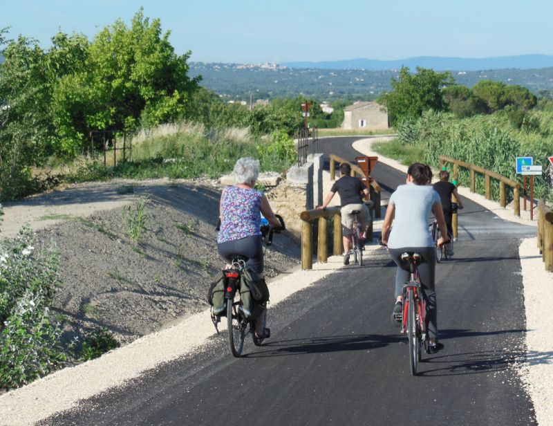
Fahrrad fahren im Luberon
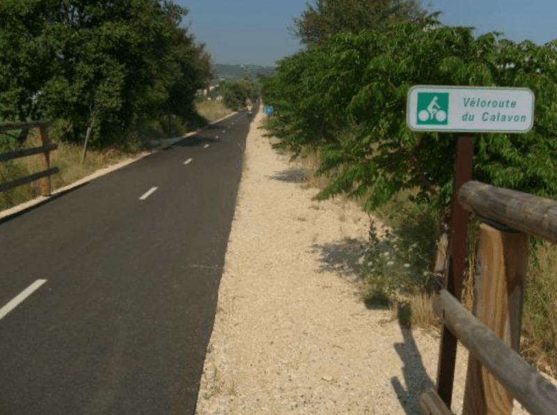
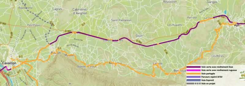
Véloroute du Calavon - on the track bed to the Roman stone arch bridge "Pont Julien"
Les Lavandiens in Bonnieux
Pont-Julien, Bonnieux, Frankreich
Unnamed Road, 84480 Bonnieux, Frankreich
43° 51' 45.1" N 5° 18' 23.7" E
43.8625324 5.3065809
• Head south on Chemin Romieu. Go for 109 m.
• Take the 3rd exit from roundabout onto D108 toward D149/Roussillon/Apt. Go for 566 m.
• Take the 1st exit from roundabout onto D900 toward Digne/Sisteron/Apt. Go for 1.6 km.
• Turn left onto Chemin de Saint-Estève (C5) toward La Coquillade. Go for 763 m.
• Continue straight ahead. Go for 148 m.
• Continue toward Lieu-dit La Coquillade. Go for 250 m.
• Continue on Lieu-dit La Coquillade. Go for 54 m.
• Arrive at Lieu-dit La Coquillade. Your destination is on the right.
☍
3,5 km
( 5 min.)
Zwischenstopp in La Coquillade, Gargas, Frankreich
La Coquillade, 84400 Gargas, Frankreich
43° 52' 49.3" N 5° 18' 58.3" E
43.8803640 5.3161850
• Head toward La Coquillade on Lieu-dit La Coquillade. Go for 452 m.
• Continue on Chemin de Saint-Estève (C5). Go for 763 m.
• Turn left onto D900. Go for 3.5 km.
• Pass 2 roundabouts and continue on Avenue de Lançon (D900). Go for 1.9 km.
• Take the 3rd exit from roundabout onto Avenue de Lançon (D900) toward Sisteron/Digne. Go for 1.8 km.
• Turn left onto Pont des Cordeliers (D22) toward Rustrel/Banon/St Christol/St Michel/Sault. Go for 1.5 km.
• Take the 1st exit from roundabout onto Avenue de Viton (D22). Go for 7.5 km.
• Take the 3rd exit from roundabout onto Route d'Apt (D30) toward Sault/Saint-Christol/Rustrel. Go for 656 m.
• Turn left onto Place de la Fête. Go for 26 m.
• Turn right onto Chemin de la Gravière. Go for 12 m.
• Arrive at Chemin de la Gravière. Your destination is on the right.
☍
18,1 km
( 20 min.)
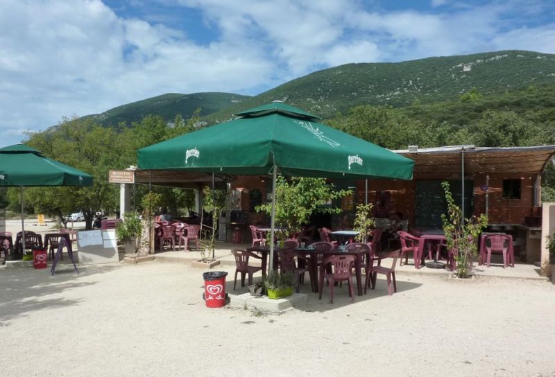
Essen /Weinprobe im Restaurant Les Vignes & son Jardin
Day
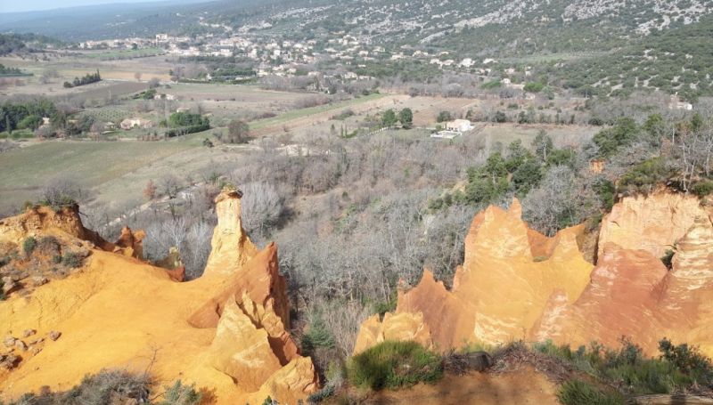
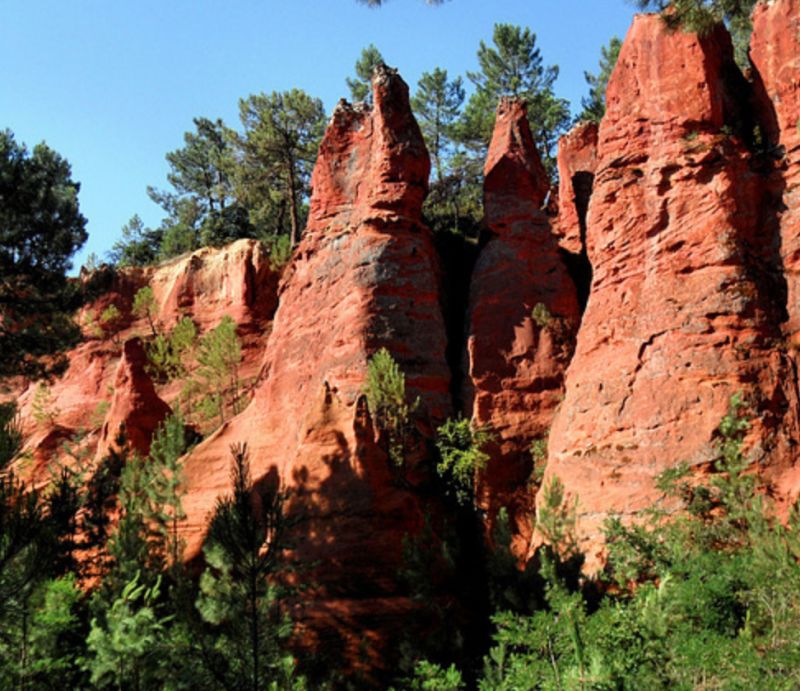
Rustrel, Frankreich
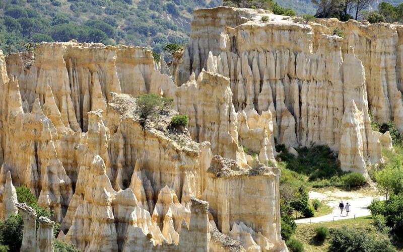
to the ocher cliffs of Rustrel - mother nature in a real flash of colour
The Colorado of Rustrel, also known as the American West in Provence.
84400 Rustrel, Frankreich
43° 55' 28.3" N 5° 29' 4.2" E
43.9245320 5.4845040
• Head toward Impasse de Fargeon on Chemin de la Gravière. Go for 8 m.
• Turn slightly right onto Chemin de la Gravière. Go for 94 m.
• Turn right onto Rue de l'Église. Go for 46 m.
• Turn right onto Rue de l'Église. Go for 42 m.
• Turn right onto Place de la Fête (D30). Go for 654 m.
• Take the 2nd exit from roundabout onto D22 toward Apt. Go for 951 m.
• Turn left onto Route de Notre-Dame des Anges. Go for 313 m.
• Arrive at Route de Notre-Dame des Anges. Your destination is on the left.
☍
2,1 km
( 3 min.)
Camping Le Colorado
quartier notre dame des anges, 84400, Rustrel, France
43° 54' 47.9" N 5° 28' 13.1" E
43.9133000 5.4703000
• Head toward Lieu-dit Saint Pierre on Route de Notre-Dame des Anges. Go for 313 m.
• Turn right onto D22. Go for 913 m.
• Take the 2nd exit from roundabout onto D22 toward Banon/Gignac/Colorado-Provençal. Go for 1.0 km.
• Turn right onto Chemin Saint-Joseph. Go for 424 m.
• Turn left onto Voie de la Poste. Go for 582 m.
• Turn left onto Voie de Viens. Go for 112 m.
• Arrive at Voie de Viens. Your destination is on the right.
☍
3,3 km
( 5 min.)
restaurant les mille couleurs, 84400 Rustrel, Frankreich
Parking space at the ocher quarries / Le Colorado Provence
quartier le logis neuf parking du Colorado provençal, 84400 Rustrel, Frankreich
43° 55' 10.8" N 5° 29' 58.6" E
43.9196770 5.4996240
• Head northwest on Voie de Viens. Go for 118 m.
• Turn left onto D22. Go for 1.5 km.
• Take the 2nd exit from roundabout onto Route de Saint-Saturnin (D179) toward St Saturnin/Lagarde-d'Apt. Go for 357 m.
• Continue on Lieu-dit Meille (D179). Go for 84 m.
• Continue on Route Saint-Saturnin (D179). Go for 1.1 km.
• Continue on Lieu-dit Saint-Maurin (D179). Go for 89 m.
• Continue on Route Saint-Saturnin (D179). Go for 878 m.
• Continue on D214 toward St Saturnin-lès-Apt. Go for 101 m.
• Continue on D179. Go for 959 m.
• Continue on Route de Rustrel (D179). Go for 4.7 km.
• Turn right onto Route d'Apt (D943). Go for 1.2 km.
• Turn left onto D2. Go for 3.5 km.
• Turn left onto Route de Roussillon (D227). Go for 1.4 km.
• Continue on Voie de Roussillon à Saint-Saturnin-d'Apt (D227). Go for 2.8 km.
• Continue on Route de Saint-Saturnin (D227). Go for 1.4 km.
• Turn left onto Route de Saint-Michel (D227). Go for 58 m.
• Take the 1st exit from roundabout onto Avenue Dame Sirmonde (D169). Go for 470 m.
• Turn left onto Rue des Bourgades. Go for 186 m.
• Turn slightly left onto Rue des Bourgades. Go for 89 m.
• Turn left onto Rue de l'Arcade. Go for 18 m.
• Arrive at Rue de l'Arcade. Your destination is on the right.
☍
21,0 km
( 21 min.)
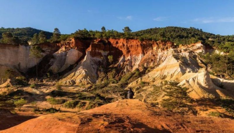
Wanderung im Le Colorado Provence (Ockerbrüche)
Day
Roussillon, Frankreich
84220 Roussillon, Frankreich
43° 54' 8.3" N 5° 17' 34.6" E
43.9022930 5.2929360
• Head toward Rue des Bourgades on Rue de l'Arcade. Go for 18 m.
• Turn left onto Rue des Bourgades. Go for 54 m.
• Turn right onto Place du Pasquier. Go for 48 m.
• Turn right onto Avenue de la Burlière (D105). Go for 477 m.
• Turn left onto Avenue Jean-Étienne Astier (D104). Go for 189 m.
• Take the 1st exit from roundabout onto Route du Pont Julien (D149). Go for 1.5 km.
• Turn right onto D149. Go for 469 m.
• Continue on Route de Roussillon (D149). Go for 38 m.
• Arrive at Route de Roussillon (D149).
☍
2,8 km
( 4 min.)
Arie Camping Car Parking St. Josef, D149, 84220 Roussillon, Frankreich
About 1 km from the Sentier des Ocres
D149, 84220 Roussillon, Frankreich
43° 52' 49.5" N 5° 17' 22.7" E
43.8804285 5.2896420
• Head toward Chemin Rural des Devens à Roussillon on Route de Roussillon (D149). Go for 675 m.
• Continue on Route Bonnieux (D149). Go for 422 m.
• Continue on Route de Bonnieux à Roussillon (D149). Go for 1.2 km.
• Turn right onto Route Départementale 900 (D900). Go for 2.1 km.
• Pass 2 roundabouts and continue on Route de Montpellier à Coni (D900). Go for 6.1 km.
• Take ramp toward Gordes/Ménerbes/Oppède/Plan des Amandiers. Go for 356 m.
• Take the 3rd exit from roundabout onto Route de Gordes (D103). Go for 1.3 km.
• Continue on Chemin de Gordes à Bonnieux (D103). Go for 572 m.
• Continue on Route des Beaumettes (D103). Go for 552 m.
• Continue on Route de Gordes à Bonnieux (D103). Go for 1.3 km.
• Continue on Route de Cavaillon à Saint-Saturnin-lès-Apt (D103). Go for 315 m.
• Turn right onto Avenue Justin Bonfils (D2) toward Gordes. Go for 1.1 km.
• Take the 2nd exit from roundabout onto Route de Cavaillon à Sault-de-Vaucluse (D15) toward Gordes/Abbaye de Senanque/Saint-Firmin. Go for 1.4 km.
• Keep right onto Route de Cavaillon à Sault-de-Vaucluse (D15) toward Gordes Centre/Saint-Firmin. Go for 614 m.
• Take the 1st exit from Place du Marché roundabout onto Place du Château. Go for 57 m.
• Arrive at Place du Château.
☍
18,1 km
( 17 min.)
Wanderung am Sentier des Ocres
You can admire the ocher cliffs in Provence either in Roussillon or about 15 km further east at Rustrel. Both areas can also be covered in one day.
In Roussillon, the ocher quarries can be hiked via the famous "Sentier des Ocres".
Day
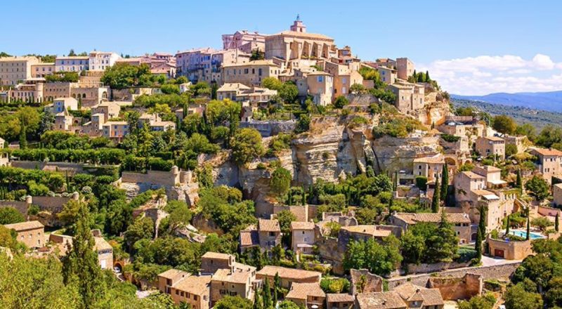
Das Adlernest Gordes, Frankreich
The typical picture book village. The well-known Hollywood film "A Good Year" was filmed here, and the silhouette of the place (certainly the most beautiful in Provence) can be found on many postcards accordingly, it has been developed for tourism and is also overcrowded (well over 1 million visitors/year! )
84220 Gordes, Frankreich
43° 54' 40.7" N 5° 12' 0.6" E
43.9113150 5.2001760
• Head toward Rue de la Poste on Place du Château. Go for 16 m.
• Continue straight ahead. Go for 21 m.
• Turn slightly left toward Place de la Poste. Go for 28 m.
• Continue on Place de la Poste. Go for 73 m.
• Continue on Chemin de l'Hôpital. Go for 137 m.
• Turn right onto Route de Murs (D15). Go for 1.4 km.
• Turn left onto Chemin de Fontanille. Go for 188 m.
• Continue straight ahead. Go for 96 m.
• Continue straight ahead. Go for 36 m.
• Arrive at your destination on the right.
☍
2,0 km
( 3 min.)
Domaine du Camping des Sources
route de Murs, 84220, Gordes, France
43° 55' 37.6" N 5° 12' 7.9" E
43.9271000 5.2022000
• Head toward Quartier Fontanille. Go for 132 m.
• Continue on Chemin de Fontanille. Go for 188 m.
• Turn right onto Route de Cavaillon à Sault-de-Vaucluse (D15). Go for 1.7 km.
• Take the 1st exit from Place du Château roundabout onto Rue de la Combe (D15). Go for 2.1 km.
• Take the 1st exit from roundabout onto Avenue Justin Bonfils (D2) toward Cavaillon/Cabrières/L'Isle sur la Sorgue/Fontaine de Vaucluse/Musée des Bories. Go for 3.3 km.
• Continue on Route de Cavaillon à Saint-Saturnin-lès-Apt (D2). Go for 469 m.
• Continue on Ancienne Route de Gordes (D15) toward Fontaine de Vaucluse/Isle sur la Sorgue. Go for 1.1 km.
• Take the 2nd exit from roundabout onto Route de Cavaillon à Sault-de-Vaucles (D15). Go for 1.2 km.
• Continue on D15. Go for 281 m.
• Continue on Lieu-dit Les Rouges (D15). Go for 184 m.
• Continue on D15. Go for 438 m.
• Take the 2nd exit from roundabout onto Route d'Avignon (D900) toward A7/Avignon/Carpentras/Caumont/L'Isle sur la Sorgue/Fontaine de Vaucluse. Go for 788 m.
• Take the 2nd exit from roundabout onto D901 toward L'Isle sur la Sorgue/Lagnes/Fontaine de Vaucluse. Go for 2.5 km.
• Take the 2nd exit from Route d'Apt roundabout onto Route de Montpellier à Coni (D901). Go for 5.1 km.
• Take the 3rd exit from Rond-Point Général de Gaulle roundabout onto Cours René Char. Go for 246 m.
• Take the 2nd exit from Rond-Point des Névons roundabout onto Cours René Char. Go for 298 m.
• Turn left onto Lotissement Le Clos des Nevons. Go for 38 m.
• Turn right onto Lotissement Le Clos des Nevons. Go for 122 m.
• Arrive at Lotissement Le Clos des Nevons. Your destination is on the left.
☍
20,1 km
( 22 min.)
Day
Day
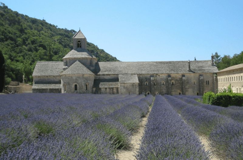
mit dem Fahrrad zur Abbaye Notre Dame de Senanque (japanieren-fotografieren)
Such a photo can only be taken in a very short time window at the beginning of June, after which the lavender is harvested.
Notre-Dame de Sénanque is a monastery of the Cistercian order in the territory of the municipality of Gordes
Day
L'Isle-sur-la-Sorgue, Frankreich
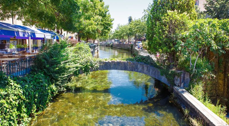
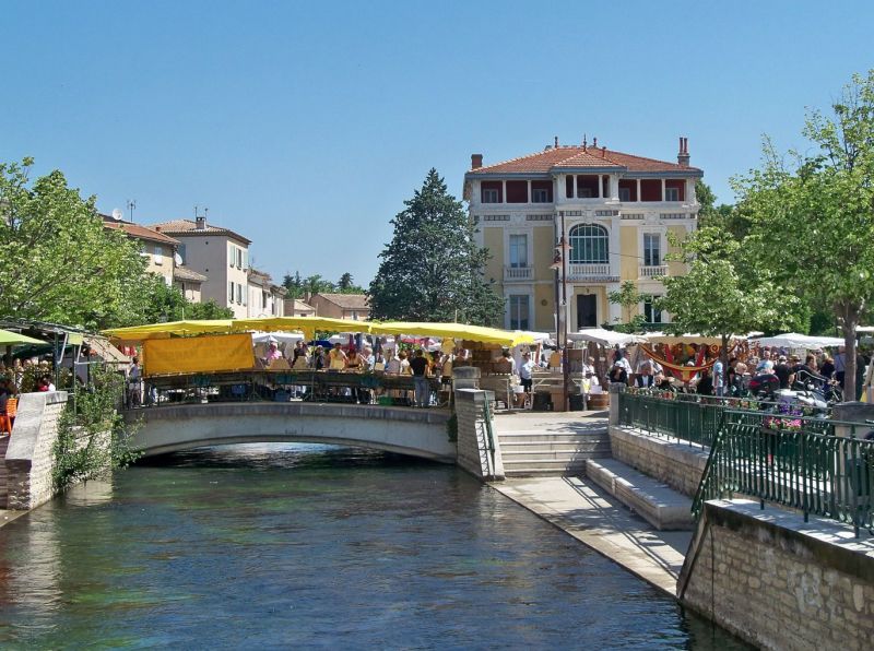
L'Isle-sur-la-Sorgue - The old town is a tip for antique lovers.
84800 L'Isle-sur-la-Sorgue, Frankreich
43° 54' 51.1" N 5° 3' 25.6" E
43.9141900 5.0571060
• Head west on Lotissement Le Clos des Nevons. Go for 122 m.
• Turn left onto Lotissement Le Clos des Nevons. Go for 38 m.
• Turn right onto Cours René Char. Go for 255 m.
• Take the 2nd exit from Rond-Point des Névons roundabout onto Cours René Char. Go for 226 m.
• Take the 3rd exit from Rond-Point Général de Gaulle roundabout onto Avenue des 4 Otages (D901). Go for 635 m.
• Take the 2nd exit from roundabout onto Avenue de l'Égalité (D938). Go for 341 m.
• Take the 1st exit from roundabout onto Route de Caumont (D25). Go for 320 m.
• Pass 2 roundabouts and continue on Route de Caumont (D25). Go for 2.7 km.
• Continue on Route de Fontaine du Vaucluse (D25). Go for 903 m.
• Turn left onto Route des Vignères (D98). Go for 2.2 km.
• Take the 1st exit from roundabout onto Route de Banon (D900). Go for 7.8 km.
• Take the 2nd exit from roundabout onto Route de Marseille (N7) toward Avignon/Caumont. Go for 2.4 km.
• Take the 3rd exit from roundabout onto Route de Marseille (N7) toward Avignon. Go for 2.1 km.
• Take the 2nd exit from roundabout onto Route de Marseille (N7) toward Avignon. Go for 2.7 km.
• Take the 2nd exit from roundabout onto Avenue Pierre Semard (D907) toward N7/Avignon-Centre. Go for 1.3 km.
• Keep left onto Avenue Pierre Semard toward Centre Ville. Go for 369 m.
• Pass 3 roundabouts and continue on Avenue Pierre Semard. Go for 1.5 km.
• Turn right onto Boulevard Limbert. Go for 362 m.
• Turn left onto Porte Thiers. Go for 51 m.
• Continue on Rue Thiers. Go for 383 m.
• Turn right onto Rue Paul Saïn. Go for 234 m.
• Turn left onto Rue du Portail Matheron. Go for 69 m.
• Continue on Rue Carnot. Go for 151 m.
• Turn left onto Rue Saint-Jean le Vieux. Go for 31 m.
• Continue on Rue Florence. Go for 48 m.
• Turn right onto Place Jérusalem. Go for 98 m.
• Continue on Place Carnot. Go for 16 m.
• Continue on Rue Corderie. Go for 58 m.
• Continue on Place Nicolas Saboly. Go for 57 m.
• Turn slightly right onto Rue Favart. Go for 74 m.
• Continue on Place de l'Horloge. Go for 19 m.
• Turn right onto Place de l'Horloge. Go for 17 m.
• Turn right onto Place de l'Horloge. Go for 31 m.
• Turn left onto Rue Félicien David. Go for 14 m.
• Arrive at Rue Félicien David. Your destination is on the right.
☍
27,6 km
( 34 min.)
Flohmarkt - Tag
The Tourist Office lists current event dates
Day
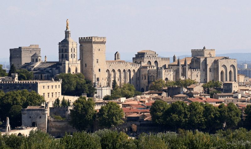
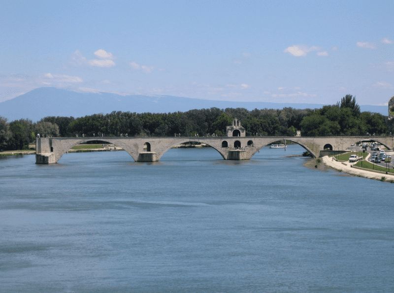
Avignon, Frankreich
The old town with the Gothic papal palace (Palais des Papes) from the 14th century, the bishop's complex, the Rocher des Doms and the famous bridge, the Pont Saint-Bénézet, is a UNESCO World Heritage Site .
1st picture: Historical center around the Papal Palace
2nd picture: The Pont d'Avignon on the "little Rhône", in the background the Mont Ventoux
43° 56' 57.5" N 4° 48' 19.9" E
43.9493170 4.8055280
• Head toward Passage Agricol Moureau on Rue Félicien David. Go for 48 m.
• Turn right onto Rue Racine. Go for 138 m.
• Continue on Place de la Madeleine. Go for 16 m.
• Turn left onto Rue Saint-Étienne. Go for 169 m.
• Turn slightly left onto Rue du Rempart du Rhône. Go for 78 m.
• Turn right onto Porte de l'Oulle. Go for 9 m.
• Turn slightly right onto Boulevard du Rhône. Go for 26 m.
• Continue on Pont Édouard Daladier. Go for 489 m.
• Turn right onto Chemin de la Barthelasse. Go for 651 m.
• Arrive at Chemin de la Barthelasse.
☍
1,6 km
( 4 min.)
Camping Du Pont D'avignon
chemin de la Barthelasse 10, 84000, Avignon, France
43° 57' 24" N 4° 48' 5.8" E
43.9566700 4.8016000
• Head northeast on Chemin de la Barthelasse. Go for 48 m.
• Turn left toward Route de l'Islon/D228. Go for 29 m.
• Turn left onto Route de l'Islon (D228). Go for 697 m.
• Turn left onto Rue Joseph Noël Clamon. Go for 225 m.
• Turn right onto Pont Édouard Daladier. Go for 379 m.
• Turn right toward Route d'Aramon/D2. Go for 92 m.
• Turn right onto Route d'Aramon (D2). Go for 617 m.
• Turn right toward A9/Bagnols S/C./Les Angles/Nîmes. Go for 114 m.
• Take ramp onto N100. Go for 3.8 km.
• Take the 2nd exit from roundabout onto D6580 toward A9/(Orange)/Roquemaure/Pujaut. Go for 2.2 km.
• Pass 4 roundabouts and continue on D6580. Go for 6.3 km.
• Take the 3rd exit from roundabout onto Échangeur de Roquemaure. Go for 548 m.
• Take ramp onto A9 (La Languedocienne) toward Orange/Lyon. Go for 14.3 km.
• Take exit 21 toward Orange-Centre/A7 (Marseille)/Orange/Carpentras/Vaison la Romaine. Go for 919 m.
• Take the 2nd exit from roundabout onto Avenue Charles de Gaulle (D17) toward Centre-Ville. Go for 258 m.
• Turn right toward Avenue Charles de Gaulle/D17. Go for 28 m.
• Take the 3rd exit from roundabout onto Avenue Charles de Gaulle (D17) toward Centre Ville. Go for 384 m.
• Take the 3rd exit from roundabout onto Cours Aristide Briand toward Avignon/Carpentras/Montélimar/Gap/Vaison la R. Go for 264 m.
• Continue on Rue Auguste Lacour. Go for 96 m.
• Continue on Boulevard Édouard Daladier (N7) toward Avignon/Camaret/Vaison la R. Go for 96 m.
• Turn right onto Rue du Fond du Sac. Go for 86 m.
• Turn left onto Rue du Renoyer. Go for 12 m.
• Arrive at Rue du Renoyer. Your destination is on the right.
☍
31,6 km
( 29 min.)
Day
Day
Day
Day
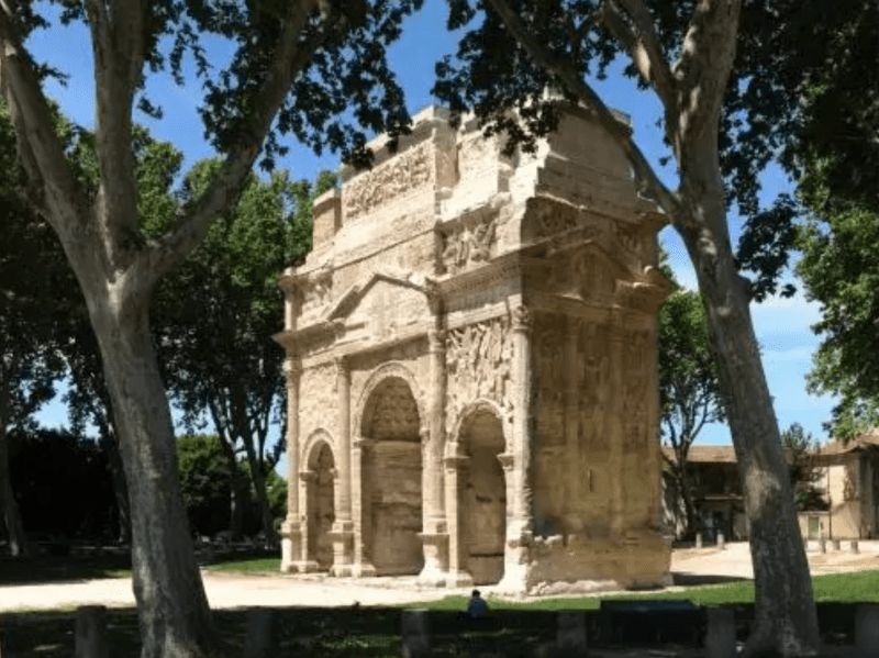
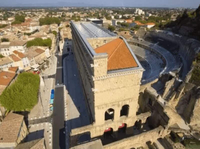
Orange, Frankreich
Orange in France: A journey through time to Provence in antiquity. The triumphal arch of Orange was built in the 1st century.
It is the fact that the Romans left unmistakable traces here, as in so many places in Provence. An excellently preserved theater invites you to visit.
In 1981 these buildings were included in the list of World Heritage Sites by UNESCO.
84100 Orange, Frankreich
44° 8' 17.2" N 4° 48' 27" E
44.1380989 4.8075110
• Head toward Rue du Tillet on Rue du Renoyer. Go for 66 m.
• Turn left onto Rue Caristie. Go for 39 m.
• Turn left onto Boulevard Édouard Daladier (N7). Go for 196 m.
• Turn right onto Avenue de l'Arc de Triomphe (N7) toward Montélimar/Gap/Valréas/Piolenc. Go for 354 m.
• Take the 2nd exit from Rond-Point de l'Arc de Triomphe roundabout onto Avenue du Maréchal de Lattre de Tassigny (N7). Go for 395 m.
• Turn left onto Rue du Bourbonnais toward Le Jonquier. Go for 197 m.
• Take the 1st exit from roundabout onto Rue du Bourbonnais. Go for 343 m.
• Take the 1st exit from roundabout onto Rue Alexis Carrel. Go for 209 m.
• Turn left onto Rue Alexis Carrel. Go for 47 m.
• Arrive at Rue Alexis Carrel. Your destination is on the left.
☍
1,8 km
( 5 min.)
Camping Manon
Rue Alexis Carrel, 84100, Orange, France
44° 8' 48" N 4° 47' 46" E
44.1466600 4.7961100
• Head east on Rue Alexis Carrel. Go for 47 m.
• Turn right onto Rue Alexis Carrel. Go for 192 m.
• Pass 3 roundabouts and continue on Rue Alexis Carrel. Go for 853 m.
• Turn left onto Rue Paul Marquion. Go for 64 m.
• Turn slightly right toward Rue Agis Rigord. Go for 13 m.
• Take the 2nd exit from roundabout onto Rue Agis Rigord. Go for 206 m.
• Take the 1st exit from roundabout onto Route de Caderousse (D17). Go for 583 m.
• Continue on D17. Go for 2.7 km.
• Continue on Lieu-dit Le Chemin d'Orange (D17). Go for 153 m.
• Continue on D17. Go for 559 m.
• Continue on Lieu-dit le moulin (D17). Go for 175 m.
• Continue on D17. Go for 197 m.
• Continue on Lieu-dit Bayard (D17). Go for 83 m.
• Continue on Route d'Orange (D17). Go for 800 m.
• Take the 3rd exit from roundabout onto Route de Châteauneuf (D17). Go for 53 m.
• Turn right onto D17 A. Go for 456 m.
• Continue on D237. Go for 925 m.
• Continue on Lieu-dit Les Islons (D237). Go for 633 m.
• Continue on D237. Go for 1.3 km.
• Take the 2nd exit from roundabout onto D238. Go for 3.4 km.
• Continue on D138 A. Go for 2.5 km.
• Take the 3rd exit from roundabout onto D138 B. Go for 765 m.
• Keep right toward D138 B. Go for 71 m.
• Continue on D765. Go for 489 m.
• Take the 3rd exit from roundabout onto D765 A. Go for 1.9 km.
• Take the 2nd exit from roundabout onto N580 toward Bagnols S/C. Go for 4.4 km.
• Take the 2nd exit from Rond-Point Constant Compère-Morel roundabout onto Avenue Georges Besse (N580) toward Pont St Esprit/Montélimar/Nîmes/Bagnols-Centre. Go for 758 m.
• Take the 2nd exit from Rond-Point Edgar Tailhades roundabout onto Avenue de la Mayre (D6) toward Montélimar/Pont St Esprit/Alès/Bagnols-Centre/Nîmes. Go for 1.4 km.
• Take the 1st exit from Rond-Point Jean Monnet roundabout onto Route de Lyon (N86) toward A7/Montélimar/St Nazaire/Pont St Esprit. Go for 375 m.
• Take the 2nd exit from Rue des Grenadiers roundabout onto Avenue François Mitterrand (N86). Go for 526 m.
• Take the 2nd exit from Rue des Grenadiers roundabout onto Route de Saint-Gervais (D980) toward Barjac/St Gervais. Go for 2.8 km.
• Take the 2nd exit from roundabout onto D980. Go for 5.7 km.
• Turn left onto Route de Saint-Laurent (D166). Go for 882 m.
• Continue on Lieu-dit Montagnac (D166). Go for 94 m.
• Continue on Lieu-dit Ferme de l'Islon (D166). Go for 205 m.
• Continue on Route de Saint-Laurent (D166). Go for 306 m.
• Keep right onto D166. Go for 37 m.
• Continue on Route de Donnat (D166). Go for 258 m.
• Turn right onto Grand Rue. Go for 135 m.
• Turn left onto Grand Rue. Go for 33 m.
• Continue on Place des Marronniers. Go for 19 m.
• Continue on Grand Rue. Go for 92 m.
• Turn left onto Place de la Mairie. Go for 36 m.
• Turn left onto Chemin de Bellefeuille. Go for 44 m.
• Arrive at Chemin de Bellefeuille. Your destination is on the left.
☍
37,3 km
( 43 min.)
Day
Day
30200 La Roque-sur-Cèze, Frankreich
Rated among the most beautiful villages in France, La Roque-sur-Cèze is one of the jewels of the Gard.
44° 11' 36.1" N 4° 31' 6.4" E
44.1933719 4.5184380
• Head toward Montée du Château on Chemin de Bellefeuille. Go for 44 m.
• Turn right onto Place de la Mairie. Go for 36 m.
• Turn right onto Grand Rue. Go for 92 m.
• Continue on Place des Marronniers. Go for 19 m.
• Continue on Grand Rue. Go for 33 m.
• Turn right onto Grand Rue. Go for 135 m.
• Turn left onto Route de Donnat (D166). Go for 258 m.
• Continue on D166. Go for 37 m.
• Continue on Route de Saint-Laurent (D166). Go for 274 m.
• Arrive at Route de Saint-Laurent (D166). Your destination is on the left.
☍
0,9 km
( 2 min.)
Aire CAMPING-CAR PARK, 5083A Route de Saint-Laurent, 30200 La Roque-sur-Cèze, Frankreich
5083A Route de Saint-Laurent, 30200 La Roque-sur-Cèze, Frankreich
44° 11' 45.3" N 4° 31' 21.6" E
44.1959154 4.5226724
• Head toward Impasse de la Coste on Route de Saint-Laurent (D166). Go for 274 m.
• Keep right onto D166. Go for 37 m.
• Continue on Route de Donnat (D166). Go for 2.8 km.
• Continue on D166. Go for 643 m.
• Turn left onto Lieu-dit La Bégude (D143) toward Bagnols S/Cèze/Donnat. Go for 38 m.
• Continue on D143. Go for 1.2 km.
• Continue on Lieu-dit le moulin de Maton (D143). Go for 32 m.
• Continue on D143. Go for 62 m.
• Continue on Route de la Roque-sur-Cèze (D143). Go for 529 m.
• Turn right onto Route de Carmes (D166). Go for 231 m.
• Keep left onto Chemin de Carmes (D166). Go for 401 m.
• Continue on D166. Go for 483 m.
• Continue on Rue du Colombier (D166). Go for 313 m.
• Continue on Rue du Pont à Vallabrix (D166). Go for 111 m.
• Turn slightly left onto Route de Saint-Laurent à Carnols (D166). Go for 463 m.
• Turn slightly right onto D6. Go for 7.9 km.
• Turn left onto Route de Bagnols-sur-Cèze (D23) toward St Laurent la Vernède/St Quentin Poterie/Uzès. Go for 2.3 km.
• Continue on D23. Go for 150 m.
• Continue on Route d'Uzès (D23). Go for 2.6 km.
• Continue on D23. Go for 3.6 km.
• Continue on Route de Saint-Laurent-la-Vernède (D23). Go for 833 m.
• Continue on Avenue Pierre de Cabissole (D23). Go for 167 m.
• Continue on D23. Go for 33 m.
• Continue on Avenue Pierre de Cabissole (D23). Go for 296 m.
• Take the 2nd exit from roundabout onto Avenue du 14 Juillet (D23). Go for 388 m.
• Continue on Avenue François Jean (D23). Go for 184 m.
• Continue on Route d'Uzès (D23). Go for 2.5 km.
• Turn right onto D982. Go for 1.8 km.
• Turn right onto Boulevard Charles Gide. Go for 250 m.
• Turn left onto Place Albert 1er. Go for 32 m.
• Continue on Rue Jacques d'Uzès. Go for 98 m.
• Continue on Place Dampmartin. Go for 17 m.
• Continue on Rue Pélisserie. Go for 20 m.
• Turn left onto Rue de l'Épée. Go for 29 m.
• Arrive at Rue de l'Épée. Your destination is on the right.
☍
30,8 km
( 37 min.)
Day
zu den Cascades du Sautadet (Kaskaden von Sautadet) und Stadtbesichtigung
The Sautadet cascades are gorges and waterfalls in the Cèze river. These natural waterfalls and whirlpools, which have dug themselves into the white limestone over a width of more than 500 meters, are an impressive and also very loud natural spectacle
Day
Day
Uzès, Frankreich
Uzès is a cozy town with many undiscovered sights.
30700 Uzès, Frankreich
44° 0' 43.6" N 4° 25' 11.8" E
44.0121100 4.4199460
• Head toward Rue Pélisserie on Rue de l'Épée. Go for 29 m.
• Turn left onto Rue Pélisserie. Go for 63 m.
• Turn left onto Rue du 4 Septembre. Go for 57 m.
• Turn right onto Place d'Austerlitz. Go for 91 m.
• Turn left onto Boulevard Victor Hugo. Go for 165 m.
• Continue on Rue de l'Évêché. Go for 116 m.
• Continue on Rue Saint-Julien. Go for 125 m.
• Turn left onto Boulevard Charles Gide. Go for 57 m.
• Turn right onto Rue du Collège. Go for 288 m.
• Turn right onto Rue Saint-Firmin. Go for 48 m.
• Arrive at Rue Saint-Firmin. Your destination is on the left.
☍
1,0 km
( 3 min.)
Domaine Saint Firmin
Rue Masbourguet, 30700, Uzès, Frankreich
44° 0' 59" N 4° 25' 17" E
44.0163889 4.4213889
• Head south on Rue Saint-Firmin. Go for 48 m.
• Turn left onto Place Bosc. Go for 288 m.
• Turn right onto Boulevard Charles Gide. Go for 463 m.
• Continue on Boulevard des Alliés. Go for 93 m.
• Continue on Place Belle-Croix. Go for 127 m.
• Turn right onto Avenue Maréchal Foch. Go for 472 m.
• Take the 2nd exit from roundabout onto Route de Nîmes (D979) toward A9/Avignon/Pont du Gard/Nîmes/Musée du Bonbon. Go for 482 m.
• Take the 2nd exit from roundabout onto Route de Nîmes (D979) toward Avignon/Nîmes. Go for 479 m.
• Take the 2nd exit from roundabout onto Route de Remoulins (D981) toward A9/Avignon/Remoulins/Pont du Gard. Go for 854 m.
• Pass 2 roundabouts and continue on Route de Remoulins (D981). Go for 2.5 km.
• Take the 3rd exit from roundabout onto Route de Remoulins (D981) toward A9/Avignon/Remoulins/Pont du Gard. Go for 4.3 km.
• Take the 2nd exit from roundabout onto D981 toward A9/Avignon/Remoulins/Pont du Gard. Go for 3.2 km.
• Take the 2nd exit from roundabout onto Route de Rémoulins (D981) toward A9/Avignon/Remoulins/Pont du Gard. Go for 730 m.
• Take the 2nd exit from roundabout onto Route de Rémoulins (D19) toward A9/Avignon/Bagnols S/C. Go for 540 m.
• Take the 1st exit from roundabout onto Route d'Uzès (D19) toward Nîmes/Remoulins. Go for 2.5 km.
• Turn right onto Avenue Geoffroy Perret (D6086) toward Beaucaire/Tarascon/Pont du Gard. Go for 366 m.
• Take the 1st exit from roundabout onto Avenue du Pont du Gard (D981) toward Pont du Gard. Go for 1.3 km.
• Continue on Lieu-dit La Couasse (D981). Go for 185 m.
• Continue on Avenue du Pont du Gard (D981). Go for 214 m.
• Turn slightly right onto D981. Go for 99 m.
• Turn left. Go for 13 m.
• Arrive at your destination on the right.
☍
19,3 km
( 27 min.)
Day
Day
Pont du Gard - Parking rive droite, Avenue du Pont du Gard, Remoulins, Frankreich
24 Avenue du Pont du Gard, 30210 Remoulins, Frankreich
43° 56' 58" N 4° 32' 32.9" E
43.9494512 4.5424602
• Head north. Go for 13 m.
• Turn right onto D981. Go for 99 m.
• Turn slightly left onto Avenue du Pont du Gard (D981). Go for 214 m.
• Continue on Lieu-dit La Couasse (D981). Go for 185 m.
• Continue on Avenue du Pont du Gard (D981). Go for 1.3 km.
• Pass 3 roundabouts and continue on D6086. Go for 14.0 km.
• Take the 2nd exit from roundabout onto D6086 toward A9/Nîmes. Go for 796 m.
• Take the 2nd exit from roundabout onto Route d'Avignon (D6086) toward Nîmes/La Paloma. Go for 1.3 km.
• Take the 2nd exit from Rond-Point Lieutenant-Colonel Pierre Colin roundabout onto Route d'Avignon (D6086) toward Nîmes-Centre. Go for 1.4 km.
• Turn right onto Route d'Avignon. Go for 1.5 km.
• Turn right onto Route d'Avignon (D127). Go for 709 m.
• Continue on Rue Pierre Semard. Go for 208 m.
• Keep left onto Rue Notre-Dame. Go for 733 m.
• Continue on Square de la Couronne. Go for 85 m.
• Turn slightly left onto Boulevard Amiral Courbet. Go for 37 m.
• Turn right onto Rue de la Couronne. Go for 82 m.
• Arrive at Rue de la Couronne.
☍
22,7 km
( 32 min.)
zum Pont du Gard
The Pont du Gard is a Roman aqueduct in the south of France in the commune of Vers-Pont-du-Gard.
The bridge is of impressive height and is one of the best preserved Roman water canals in France.
The aqueduct Pont du Gard was included in the UNESCO list in 1985 - World Heritage added.
Day
Nîmes, Frankreich
Nîmes was founded in the 6th century BC. founded and 120 BC. occupied by the Romans.
The Roman rulers left the city a rich legacy that has survived to this day and has earned it the title "Ancient History in the Present".
43° 50' 12.1" N 4° 21' 36.2" E
43.8366990 4.3600540
• Head northwest on Rue de la Couronne.
• Turn right onto Place de la Salamandre. Go for 70 m.
• Turn slightly left onto Grand'Rue. Go for 28 m.
• Turn right onto Rue des Greffes. Go for 51 m.
• Turn left onto Boulevard Amiral Courbet. Go for 188 m.
• Turn right onto Place Gabriel Péri. Go for 44 m.
• Turn left onto Place Gabriel Péri. Go for 62 m.
• Continue on Rue de Condé (D999). Go for 36 m.
• Continue on Boulevard Étienne Saintenac (D999). Go for 55 m.
• Turn left onto Boulevard Étienne Saintenac (D979). Go for 154 m.
• Continue on Boulevard Gambetta (D999). Go for 523 m.
• Turn right onto Square de la Bouquerie. Go for 25 m.
• Continue on Rue Ménard. Go for 934 m.
• Turn left onto Rue Rouget de Lisle. Go for 32 m.
• Take the 1st exit from roundabout onto Place Paul Valéry. Go for 273 m.
• Turn left onto Chemin de Tire-Cul. Go for 18 m.
• Take the 1st exit from Rond-Point de l'Octroi roundabout onto Route d'Alès (D926). Go for 3.2 km.
• Take the 2nd exit from roundabout onto Route d'Alès (N106). Go for 619 m.
• Turn left onto Route d'Anduze (D907) toward Lédignan. Go for 3.6 km.
• Turn right onto Domaine Fontbespierre. Go for 321 m.
• Turn right onto Domaine Fontbespierre. Go for 327 m.
• Arrive at Domaine Fontbespierre. Your destination is on the right.
☍
10,5 km
( 16 min.)
Au Domaine de Fontbespierre, Route d'Anduze, Nîmes, Frankreich
3358 Route d'Anduze, 30900 Nîmes, Frankreich
43° 52' 32.6" N 4° 16' 38.5" E
43.8757342 4.2773512
• Head northeast on Domaine Fontbespierre. Go for 327 m.
• Turn left onto Domaine Fontbespierre. Go for 321 m.
• Turn left onto Route d'Anduze (D907). Go for 3.6 km.
• Continue on N106 toward Nîmes. Go for 3.4 km.
• Keep left onto Boulevard Anciens Combattants en Indochine (N106) toward A9/A64. Go for 2.3 km.
• Take the 2nd exit from roundabout onto Boulevard du Pasteur Marc Boegner (N106) toward A9/A54/Montpellier/Avignon/Arles. Go for 1.4 km.
• Take the 3rd exit from Rond-Point Km Delta roundabout onto A54 toward Avignon/Montpellier/Arles/Aéroport Garons. Go for 848 m.
• Take the left exit toward Nîmes-Centre/Aéroport Garons/Arles/Marseille onto A54. Go for 28.7 km.
• Take ramp toward Arles-Centre/Arles-Barriol/Port St Louis. Go for 323 m.
• Continue on Boulevard Georges Clemenceau (D35). Go for 21 m.
• Turn right onto Boulevard Georges Clemenceau (D35). Go for 396 m.
• Continue on Boulevard Georges Clemenceau (N453). Go for 735 m.
• Turn left onto Boulevard Émile Combes. Go for 14 m.
• Turn left onto Montée Vauban. Go for 199 m.
• Turn right onto Rue de la Dominante. Go for 81 m.
• Turn slightly left onto Rue Porte de Laure. Go for 18 m.
• Turn slightly left onto Rue de la Calade. Go for 215 m.
• Arrive at Rue de la Calade. Your destination is on the left.
☍
43,0 km
( 37 min.)
Day
Day
Day
Arles, Frankreich
Arles is a city on the banks of the Rhone River in the Provence region of southern France. It is famous as a source of inspiration for Van Gogh's paintings.
Arles was once the provincial capital of the Roman Empire and is also known for the many remains from that period, including the Arles amphitheater, which today hosts theatrical performances, concerts and bullfights take place.
Under the designation "Roman and Romanesque Monuments of Arles", UNESCO summarizes seven monuments in the municipality.
43° 40' 35.9" N 4° 37' 40" E
43.6766470 4.6277769
• Head west on Rue de la Calade.
• Continue on Plan de la Cour. Go for 51 m.
• Turn right onto Rue du Palais. Go for 50 m.
• Continue on Place du Forum. Go for 41 m.
• Continue on Rue de la Place. Go for 36 m.
• Turn right onto Rue du Docteur Fanton. Go for 61 m.
• Turn left onto Rue Dominique Maïsto. Go for 84 m.
• Turn left onto Rue du Grand Prieuré. Go for 27 m.
• Continue on Place Constantin. Go for 27 m.
• Turn slightly left onto Quai Marx Dormoy. Go for 228 m.
• Continue on Quai Marx Dormoy. Go for 38 m.
• Continue on Quai de la Roquette. Go for 78 m.
• Turn left onto Rue du Port. Go for 36 m.
• Turn left onto Rue Élie Giraud. Go for 92 m.
• Turn left onto Rue Anatole France. Go for 104 m.
• Continue on Pont de Trinquetaille. Go for 190 m.
• Continue on Rue de la Camargue. Go for 158 m.
• Continue on Rue La Bruyère. Go for 35 m.
• Turn left onto Rue de la Verrerie. Go for 59 m.
• Turn slightly right onto Avenue de la Camargue. Go for 666 m.
• Arrive at Avenue de la Camargue.
☍
2,1 km
( 6 min.)
Avenue de la Camargue, Arles, Frankreich
Parking space on the Rhone, from there about 2 km walk to the city
Avenue de la Camargue, 13200 Arles, Frankreich
43° 40' 34.5" N 4° 36' 52.4" E
43.6762572 4.6145453
• Head toward Chemin de Compostelle on Avenue de la Camargue. Go for 712 m.
• Take the 1st exit from Rond-Point Maurice Étienne roundabout onto D570. Go for 566 m.
• Take the 3rd exit from Rond-Point du Vittier roundabout onto Route de Dours (N572) toward Nîmes/St Gilles/Vauvert. Go for 4.2 km.
• Take ramp toward St Gilles/Vauvert. Go for 855 m.
• Continue on Route de Dours (D572 N) toward St Gilles/Vauvert. Go for 8.4 km.
• Continue on D6572. Go for 2.4 km.
• Turn right onto Place Frédéric Mistral. Go for 28 m.
• Continue on Rue Porte des Maréchaux. Go for 116 m.
• Continue on Place de la République. Go for 65 m.
• Continue on Grand Rue. Go for 11 m.
• Turn right onto Rue de l'Hôtel de Ville. Go for 37 m.
• Arrive at Rue de l'Hôtel de Ville. Your destination is on the right.
☍
17,4 km
( 15 min.)
Day
Day
Zwischenstopp: Abteikirche Saint-Gilles, Place de la République, Saint-Gilles, Frankreich
Place de la République, 30800 Saint-Gilles, Frankreich
43° 40' 37.2" N 4° 25' 56" E
43.6769919 4.4322146
• Head toward Rue Michelet on Rue de l'Hôtel de Ville. Go for 7 m.
• Turn slightly left onto Rue de l'Hôtel de Ville. Go for 86 m.
• Turn right onto Rue Ernest Blanc. Go for 74 m.
• Turn right onto Rue Victor Hugo. Go for 53 m.
• Turn slightly left onto Rue Émile Zola. Go for 170 m.
• Turn left onto Rue de la République. Go for 24 m.
• Continue on Rue du Panier. Go for 39 m.
• Turn left onto Place Gambetta (D6572). Go for 579 m.
• Turn right onto Route des Iscles (D179) toward Aigues-Mortes/Sylvéréal. Go for 136 m.
• Continue on D179. Go for 406 m.
• Continue on Lieu-dit Mas Thélène (D179). Go for 85 m.
• Continue on D179. Go for 1.0 km.
• Continue on Lieu-dit Mas de la Saque (D179). Go for 91 m.
• Continue on D179. Go for 919 m.
• Continue on Lieu-dit Le Mas Blanc (D179). Go for 157 m.
• Continue on D179. Go for 1.3 km.
• Continue on Lieu-dit Le Versadou (D179). Go for 103 m.
• Continue on D179. Go for 1.4 km.
• Continue on Lieu-dit Saint-Roch (D179). Go for 81 m.
• Continue on D179. Go for 189 m.
• Continue on Lieu-dit La Fosse (D179). Go for 107 m.
• Continue on D179. Go for 697 m.
• Continue on Lieu-dit Petit Biserty (D179). Go for 92 m.
• Continue on D179. Go for 2.3 km.
• Continue on Lieu-dit Petit Canavère (D179). Go for 96 m.
• Continue on D179. Go for 175 m.
• Continue on Lieu-dit Mas Melon (D179). Go for 155 m.
• Continue on Lieu-dit Mas Combet (D179). Go for 106 m.
• Continue on D179. Go for 523 m.
• Continue on Lieu-dit Grand Canavère (D179). Go for 86 m.
• Continue on D179. Go for 1.7 km.
• Continue on Lieu-dit Bramasset (D179). Go for 94 m.
• Continue on D179. Go for 1.8 km.
• Turn left onto Lieu-dit Mas des Iscles (D179). Go for 20 m.
• Continue on D179. Go for 2.5 km.
• Continue on Lieu-dit Quatret (D179). Go for 184 m.
• Continue on D179. Go for 630 m.
• Continue on Lieu-dit Mas Paula (D179). Go for 72 m.
• Continue on D179. Go for 334 m.
• Continue on Lieu-dit Mas Terro Novo (D179). Go for 40 m.
• Continue on D179. Go for 3.3 km.
• Take the 1st exit from roundabout onto D58 toward Aigues-Mortes. Go for 8.3 km.
• Take the 3rd exit from roundabout onto D46 toward Aigues-Mortes/Le Grau du Roi/Nîmes. Go for 1.0 km.
• Take the 4th exit from roundabout onto D979. Go for 348 m.
• Continue on Route de Nîmes (D979). Go for 184 m.
• Turn right toward D979. Go for 30 m.
• Take the 3rd exit from roundabout onto Route de Nîmes (D979). Go for 1.0 km.
• Continue on Avenue de la Tour de Constance (D979). Go for 245 m.
• Turn left onto Boulevard Diderot. Go for 51 m.
• Turn slightly right. Go for 128 m.
• Arrive at your destination on the right.
☍
33,3 km
( 32 min.)
Aigues-Mortes, Frankreich
Aigues-Mortes is a cute little town known for its salt flats, pink flamingos and charming old town. The old town dates back to the 13th century when Louis IX, the city's founder, had a port built.
The salt lakes produce 500,000 tons of salt a year and are home to the Fleur de Sel
30220 Aigues-Mortes, Frankreich
43° 34' 1.8" N 4° 11' 33.3" E
43.5671720 4.1925869
• Head toward Boulevard Diderot. Go for 128 m.
• Turn slightly left onto Boulevard Diderot. Go for 51 m.
• Turn left onto D979. Go for 131 m.
• Take the 1st exit from roundabout onto Rue de la Fraternité (D718). Go for 107 m.
• Turn left onto Rue du Port. Go for 448 m.
• Turn left. Go for 23 m.
• Turn slightly left. Go for 52 m.
• Arrive at your destination on the left.
☍
0,9 km
( 3 min.)
Aire de Camping-car au Port
Rue du Port, 30220, Aigues-Mortes, Frankreich
43° 33' 59" N 4° 11' 9" E
43.5663889 4.1858333
• Head southwest. Go for 75 m.
• Turn right onto Rue du Port. Go for 448 m.
• Turn right onto Rue de la Fraternité (D718). Go for 82 m.
• Take the 2nd exit from roundabout onto D979 toward Nîmes/Centre Ville. Go for 160 m.
• Turn right onto Boulevard Diderot. Go for 51 m.
• Turn slightly right. Go for 128 m.
• Arrive at your destination on the right.
☍
0,9 km
( 2 min.)
Alternativ: Aire de Camping-Car Aigues-Mortes Boulevard Diderot 49, 30220 Aigues-Mortes, Frankreich
30220 Aigues-Mortes, Frankreich
43° 34' 1.8" N 4° 11' 33.3" E
43.5671720 4.1925869
• Head toward Boulevard Diderot. Go for 128 m.
• Turn slightly left onto Boulevard Diderot. Go for 51 m.
• Turn left onto D979. Go for 131 m.
• Take the 1st exit from roundabout onto Rue de la Fraternité (D718). Go for 353 m.
• Continue on Chemin de la Pataquière (D718). Go for 954 m.
• Take the 3rd exit from roundabout onto D62. Go for 2.2 km.
• Pass 2 roundabouts and continue on D62. Go for 4.9 km.
• Keep left onto D62 toward (Barcelone)/A9/La Grande Motte/Carnon/Montpellier. Go for 11.2 km.
• Continue on M62. Go for 744 m.
• Continue on Avenue Georges Frêche (M66). Go for 984 m.
• Keep left onto M66. Go for 2.2 km.
• Continue on D66. Go for 2.0 km.
• Continue on M66. Go for 4.4 km.
• Continue on Carrefour de l'Aéroport International. Go for 121 m.
• Continue on Avenue Jean Mermoz. Go for 303 m.
• Keep right onto Avenue Jean Mermoz. Go for 395 m.
• Continue on Rue Professeur Léon Vallois. Go for 476 m.
• Continue toward Place du 11 Novembre. Go for 61 m.
• Continue on Quai du Verdanson. Go for 394 m.
• Continue on Quai des Tanneurs. Go for 293 m.
• Continue on Avenue Bouisson Bertrand. Go for 125 m.
• Continue on Avenue Saint-Charles. Go for 344 m.
• Turn slightly left onto Rue Croix Catelan. Go for 72 m.
• Turn right onto Rue Auguste Broussonnet. Go for 124 m.
• Turn left onto Rue du Faubourg Saint-Jaumes. Go for 647 m.
• Continue on Rue Barthez. Go for 68 m.
• Turn left onto Place d'Aviler. Go for 16 m.
• Turn right onto Place d'Aviler. Go for 86 m.
• Turn left onto Rue Foch. Go for 347 m.
• Turn right onto Place des Martyrs de la Résistance. Go for 65 m.
• Arrive at Place des Martyrs de la Résistance. Your destination is on the left.
☍
34,2 km
( 35 min.)
Day
Stadtbesichtigung und mit dem Fahrrad durch die Salinen (wenn möglich im Herbst) wegen der Farben
Day
Day
Montpellier, Frankreich
Montpellier in the south of France has developed over the years into a city that can compete with international metropolises.
Montpellier was 1349 by King James III. of Mallorca to the French king Philip VI. sold by France to fill the war chest in the fight against Peter IV of Aragon to reconquer Mallorca.
43° 36' 38.8" N 3° 52' 36.2" E
43.6107690 3.8767160
• Head toward Rue Foch on Place des Martyrs de la Résistance. Go for 24 m.
• Turn left onto Place des Martyrs de la Résistance. Go for 68 m.
• Turn right onto Rue Foch. Go for 347 m.
• Turn right onto Rue la Blottière. Go for 86 m.
• Turn right toward Boulevard Professeur Louis Vialleton. Go for 20 m.
• Turn right onto Boulevard Professeur Louis Vialleton. Go for 214 m.
• Continue on Boulevard Ledru-Rollin. Go for 168 m.
• Continue on Boulevard du Jeu de Paume. Go for 46 m.
• Turn right onto Rue Marceau. Go for 224 m.
• Continue on Rue Chaptal. Go for 474 m.
• Turn left onto Boulevard Renouvier. Go for 214 m.
• Turn left onto Rue Raoux. Go for 31 m.
• Turn right onto Avenue de Toulouse. Go for 10 m.
• Turn left onto Avenue Georges Clemenceau. Go for 18 m.
• Turn right onto Avenue de Toulouse. Go for 83 m.
• Turn left toward Avenue de la Liberté. Go for 9 m.
• Take left ramp onto Avenue de la Liberté. Go for 934 m.
• Continue on Carrefour des Alizés. Go for 89 m.
• Continue on Boulevard Jacques Fabre de Morlhon. Go for 1.4 km.
• Take the 3rd exit from Rond-Point des Prés d'Arènes roundabout onto Avenue de Palavas (M986) toward Les Aiguerelles/Saint-Martin/Port Marianne/Antigone/Gare Saint-Roch. Go for 278 m.
• Turn sharp right onto Avenue de Palavas. Go for 376 m.
• Continue on Avenue Docteur Jacques Fourcade. Go for 544 m.
• Take the 1st exit from roundabout onto Rue de la Rauze. Go for 455 m.
• Turn left onto Chemin de la 1ère Écluse. Go for 124 m.
• Arrive at Chemin de la 1ère Écluse. Your destination is on the right.
☍
6,2 km
( 15 min.)
Camping Le Floréal, Rue de la Première Ecluse, Lattes, Frankreich
Rue de la Première Ecluse, 34970 Lattes, Frankreich
43° 35' 21.7" N 3° 54' 6.8" E
43.5893600 3.9018950
• Head toward Rue de la Rauze on Chemin de la 1ère Écluse. Go for 124 m.
• Turn left onto Rue de la Rauze. Go for 28 m.
• Keep right onto Chemin du Floréal. Go for 483 m.
• Turn left onto Chemin de Saint-Hubert. Go for 534 m.
• Take the 2nd exit from Rond-Point de la Céreirède roundabout onto Route de Palavas (M986) toward A9/Montpellier. Go for 1.0 km.
• Take ramp onto A709 toward Barcelone/Toulouse/Béziers/Sète. Go for 6.8 km.
• Continue on A9 (La Languedocienne). Go for 14.3 km.
• Take exit 33 toward Sète/Frontignan/Balaruc/Mèze. Go for 1.1 km.
• Keep left onto D600 toward Sète/Montpellier/Balaruc/Frontignan/Gigean/Fabrègues/Villeveyrac/Z.I. des Trouyaux. Go for 6.8 km.
• Take the 2nd exit from Rond-Point Salvador Allende roundabout onto Avenue André Malraux (D2 E2) toward Béziers/Balaruc/Z.A. la Bordelaise/Z.A. la Peyrade. Go for 1.3 km.
• Take ramp onto D2 E6. Go for 2.4 km.
• Take ramp. Go for 32 m.
• Take the 2nd exit from roundabout onto D2 toward Béziers/Agde. Go for 259 m.
• Take the 2nd exit from roundabout onto Boulevard de Verdun (D2) toward Béziers/Agde/Métairies. Go for 339 m.
• Keep right onto Boulevard de Verdun (D2) toward Béziers/Agde/Métairies. Go for 1.6 km.
• Keep left onto Boulevard Camille Blanc (D2) toward Agde/Béziers. Go for 1.1 km.
• Take the 2nd exit from Rond-Point du Vignerai roundabout toward Béziers/Marseillan/Agde/Château de Villeroy Listel/Les Salins. Go for 298 m.
• Continue on Route des 4 Chansons. Go for 313 m.
• Pass 3 roundabouts and continue on N112. Go for 4.9 km.
• Take the 2nd exit from roundabout. Go for 114 m.
• Turn left. Go for 28 m.
• Arrive at your destination on the right.
☍
44,0 km
( 41 min.)
Day
Parking 3 Dingues
Route d'Agde (N 112), 34200, Sète, Frankreich
43° 22' 0" N 3° 36' 58" E
43.3666667 3.6161111
• Head southwest. Go for 28 m.
• Turn right toward N112. Go for 42 m.
• Take the 2nd exit from roundabout onto N112 toward Béziers/Marseillan/Agde. Go for 2.0 km.
• Pass 3 roundabouts and continue on N112. Go for 5.9 km.
• Take the 2nd exit from roundabout onto D51 E5 toward Marseillan-Plage/Agde/Béziers. Go for 255 m.
• Take the 1st exit from roundabout onto Avenue du Clavelet (D612) toward A9/Béziers/Agde/Gare. Go for 954 m.
• Take the 2nd exit from roundabout onto Avenue du Clavelet (D612) toward A9/Béziers/Agde. Go for 1.7 km.
• Take ramp onto D612 toward A9/Béziers/Le Cap d'Agde/Le Grau d'Agde. Go for 8.5 km.
• Take ramp onto D612 A toward A9/A75/Millau/Bessan/Pézenas. Go for 8.0 km.
• Take the 1st exit from roundabout onto D13 toward St Thibéry/Pézenas. Go for 224 m.
• Take the 3rd exit from roundabout onto Route de Saint-Thibéry (D13) toward A75/Millau/Clermont-Fd/Montblanc/St Thibery/Florensac/Pézenas. Go for 9.3 km.
• Pass 2 roundabouts and continue on Boulevard Rhin et Danube (D13). Go for 1.5 km.
• Take the 1st exit from Rond-Point Marcel Paul roundabout onto Avenue de Plaisance. Go for 176 m.
• Take the 2nd exit from roundabout onto Avenue de Plaisance. Go for 143 m.
• Arrive at Avenue de Plaisance. Your destination is on the right.
☍
38,7 km
( 34 min.)
Day
mit dem Fahrrad nach Sete
Day
mit dem Fahrrad nach Agde
Day
Day
Parkplatz am Sportgelände, Avenue de Plaisance, Pézenas, Frankreich
Avenue de Plaisance, 34120 Pézenas, Frankreich
43° 27' 37.7" N 3° 24' 51.1" E
43.4604623 3.4141964
• Head toward Rue Jean Dunant on Avenue de Plaisance. Go for 102 m.
• Take the 2nd exit from roundabout onto Avenue de Plaisance. Go for 164 m.
• Take the 1st exit from Rond-Point Marcel Paul roundabout onto Boulevard Martin Luther King (D13). Go for 398 m.
• Take the 3rd exit from roundabout onto D13. Go for 8.7 km.
• Pass 4 roundabouts and continue on Avenue de Faugères (D13). Go for 15.2 km.
• Turn right onto D909. Go for 2.8 km.
• Continue on D909 A. Go for 4.1 km.
• Take the 5th exit from roundabout onto D160. Go for 178 m.
• Continue on Lieu-dit Le Pech du Pont (D160). Go for 85 m.
• Continue on D160. Go for 767 m.
• Continue on Route de Cancastel (D160). Go for 701 m.
• Continue on Route de la Plaine (D160). Go for 1.8 km.
• Take the 1st exit from roundabout onto D22 E1. Go for 249 m.
• Take the 4th exit from roundabout onto Route du Poujol (D908) toward Le Poujol S/Orb/Olargues/St Pons de Thomières. Go for 1.4 km.
• Take the 2nd exit from roundabout onto Rue des Pountils (D908). Go for 14.8 km.
• Turn left onto Pont Bonnafous (D14 E17). Go for 83 m.
• Turn left onto Avenue de Pampelune (D14 E17). Go for 134 m.
• Turn right onto Rue des Écoles. Go for 102 m.
• Continue on Rue Neuve. Go for 125 m.
• Arrive at Rue Neuve. Your destination is on the left.
☍
51,8 km
( 53 min.)
Day
Olargues, Frankreich
Olargues is located in the Jaur
valley
34390 Olargues, Frankreich
43° 33' 24.1" N 2° 54' 49.4" E
43.5567060 2.9137280
• Head toward Rue Plan de la Chapelle on Rue Neuve. Go for 125 m.
• Continue on Rue des Écoles. Go for 102 m.
• Continue on Chemin des Pialettes. Go for 216 m.
• Continue on Chemin de Coulayro. Go for 17 m.
• Turn slightly right onto Chemin de Coulayro. Go for 69 m.
• Turn left onto Lieu-dit Coulayro. Go for 25 m.
• Arrive at Lieu-dit Coulayro. Your destination is on the left.
☍
0,6 km
( 1 min.)
Area CAMPING CAR PARK Olargues, Chemin de Coulayro, 34390 Olargues, Frankreich
Bas, Chemin de Coulayro, 34390 Olargues, Frankreich
43° 33' 23" N 2° 55' 8" E
43.5563812 2.9188785
• Head toward Chemin de Coulairo on Lieu-dit Coulayro. Go for 240 m.
• Turn right onto Chemin de Coulairo. Go for 140 m.
• Turn left onto Chemin de Coulairo. Go for 187 m.
• Turn right onto D14 E17. Go for 67 m.
• Turn right onto Avenue du Champ des Horts (D14 E17). Go for 77 m.
• Keep right onto Avenue du Champ des Horts (D14 E17). Go for 72 m.
• Continue on Avenue de la Gare (D14 E17). Go for 122 m.
• Continue on Avenue de Pampelune (D14 E17). Go for 134 m.
• Turn right onto Pont Bonnafous (D14 E17). Go for 83 m.
• Turn right onto D908. Go for 14.7 km.
• Take the 2nd exit from roundabout onto D908. Go for 1.3 km.
• Take the 1st exit from roundabout onto D22 E1 toward Les Aires. Go for 294 m.
• Take the 2nd exit from roundabout onto Route de la Vernière (D160). Go for 1.9 km.
• Continue on Route de Cancastel (D160). Go for 701 m.
• Continue on D160. Go for 767 m.
• Continue on Lieu-dit Le Pech du Pont (D160). Go for 85 m.
• Continue on D160. Go for 18 m.
• Take the 1st exit from roundabout onto D909 A toward Béziers/Faugères. Go for 4.1 km.
• Continue on D909. Go for 22.3 km.
• Continue on D39. Go for 97 m.
• Continue on Lieu-dit Les Fontaines (D909). Go for 902 m.
• Continue on D15. Go for 2.2 km.
• Take the 2nd exit from roundabout onto Route de Bédarieux (D909). Go for 1.0 km.
• Take the 3rd exit from Rond-Point du Capt. Alfred Dreyfus roundabout onto Route de Bédarieux (D909). Go for 241 m.
• Take the 3rd exit from roundabout onto Route de Bédarieux (D909). Go for 585 m.
• Take the 2nd exit from roundabout onto Route de Bédarieux (D909). Go for 667 m.
• Continue on Avenue Maréchal Foch. Go for 546 m.
• Turn right onto Avenue Maréchal Foch. Go for 431 m.
• Keep left onto Avenue Maréchal Foch. Go for 376 m.
• Take the 3rd exit from Place de la Victoire roundabout onto Allées Paul Riquet. Go for 102 m.
• Arrive at Allées Paul Riquet. Your destination is on the left.
☍
54,4 km
( 54 min.)
Day
Stadtbesichtigung und essen im Restaurant Fleurs d'Olargues
Day
Béziers, Frankreich
34500 Béziers, Frankreich
43° 20' 39.2" N 3° 12' 56.9" E
43.3442330 3.2157950
• Head toward Rue de la Coquille on Allées Paul Riquet. Go for 262 m.
• Continue on Place Jean Jaurès. Go for 8 m.
• Turn right onto Place Jean Jaurès. Go for 124 m.
• Turn slightly right onto Place Jean Jaurès. Go for 30 m.
• Continue on Avenue d'Estienne d'Orves. Go for 52 m.
• Turn left onto Avenue d'Estienne d'Orves. Go for 86 m.
• Turn left onto Avenue Alphonse Mas. Go for 37 m.
• Turn right onto Rue Jean-Jacques Rousseau. Go for 50 m.
• Turn slightly right onto Rue du Cirque. Go for 54 m.
• Turn slightly left onto Rue du Puits des Arènes. Go for 91 m.
• Continue on Rue Canterelles. Go for 224 m.
• Turn sharp left onto Avenue Valentin Duc. Go for 33 m.
• Continue on Rue de l'Orb. Go for 78 m.
• Continue on Avenue Colonel d'Ornano (D609). Go for 281 m.
• Turn left onto Place des Alliés. Go for 58 m.
• Continue on Rue du Canal. Go for 64 m.
• Continue toward Avenue du Port-Notre-Dame/D19. Go for 26 m.
• Continue on Avenue du Port-Notre-Dame (D19). Go for 54 m.
• Turn right toward Traverse de Colombiers. Go for 666 m.
• Take the 2nd exit from Rond-Point Bachaga Boualam roundabout onto Traverse de Colombiers toward Centre Sportif-Montflourès. Go for 702 m.
• Continue on Traverse de Colombiers. Go for 28 m.
• Take the 1st exit from roundabout onto Traverse de Colombiers. Go for 44 m.
• Arrive at Traverse de Colombiers. Your destination is on the right.
☍
3,1 km
( 8 min.)
Domaine Mi-Cote, 501 Traverse de Colombiers, 34500 Béziers, Frankreich
501 Traverse de Colombiers, 34500 Béziers, Frankreich
43° 19' 54.1" N 3° 11' 30.4" E
43.3316818 3.1917716
• Head west on Traverse de Colombiers. Go for 90 m.
• Continue on Traverse de Colombiers. Go for 351 m.
• Turn sharp left onto D64. Go for 3.8 km.
• Take the 3rd exit from Rond-Point de la Mer roundabout onto A9 (La Languedocienne) toward Narbonne. Go for 22.2 km.
• Take exit 37 toward Narbonne-Centre. Go for 554 m.
• Take the 3rd exit from roundabout onto Avenue Maître Hubert Mouly (D168) toward Narbonne-Centre. Go for 617 m.
• Take the 3rd exit from Giratoire des Colonnes roundabout onto Avenue Maître Hubert Mouly toward Centre Historique. Go for 917 m.
• Take the 1st exit from Giratoire de la Borne Militaire roundabout onto Avenue de Gruissan (D32) toward Béziers/Egassiairal/Gare. Go for 304 m.
• Turn right onto Carrefour des Plages. Go for 268 m.
• Continue on Avenue Paul Tournal. Go for 76 m.
• Turn left toward Avenue Président Kennedy. Go for 26 m.
• Turn right onto Avenue Président Kennedy. Go for 374 m.
• Take the 2nd exit from Giratoire Michel Flanzy roundabout onto Boulevard du Général de Gaulle. Go for 67 m.
• Turn right onto Rue du Docteur Roux. Go for 117 m.
• Continue on Rue Cuvier. Go for 58 m.
• Turn left onto Rue Cuvier. Go for 77 m.
• Turn slightly right onto Place de Lapeyrade. Go for 17 m.
• Continue on Rue Baudin. Go for 71 m.
• Turn left onto Rue Baudin. Go for 69 m.
• Turn right onto Rue Viollet le Duc. Go for 47 m.
• Continue on Rue Armand Gauthier. Go for 134 m.
• Turn left onto Rue Gustave Fabre. Go for 117 m.
• Arrive at Rue Gustave Fabre. Your destination is on the left.
☍
30,4 km
( 25 min.)
Day
Day
Day
Narbonne, Frankreich
11100 Narbonne, Frankreich
43° 11' 3.4" N 3° 0' 11.1" E
43.1842770 3.0030780
• Head toward Rue Jean Jaurès on Rue Gustave Fabre. Go for 24 m.
• Turn right onto Rue Jean Jaurès. Go for 193 m.
• Turn right onto Boulevard Frédéric Mistral. Go for 203 m.
• Keep right onto Boulevard Marcel Sembat. Go for 462 m.
• Take the 1st exit from roundabout onto Boulevard Condorcet. Go for 121 m.
• Take the 4th exit from Jardin de la Révolution roundabout onto Boulevard du Général de Gaulle. Go for 333 m.
• Take the 2nd exit from Giratoire Michel Flanzy roundabout onto Avenue Président Kennedy. Go for 599 m.
• Keep right onto Avenue de Gruissan. Go for 390 m.
• Take the 3rd exit from Giratoire de la Borne Militaire roundabout onto Avenue Maître Hubert Mouly toward A9/Béziers/Carcassonne/Perpignan/Narbonne-Plage. Go for 977 m.
• Take the 5th exit from Giratoire des Colonnes roundabout onto Avenue Maître Hubert Mouly toward Centre Historique. Go for 679 m.
• Arrive at Avenue Maître Hubert Mouly. Your destination is on the right.
☍
4,0 km
( 9 min.)
Stellplatz bei Parc des Expositions, Aire de La Narbonnette
from there about 2 km walk to the city
Avenue Maître Hubert Mouly, 11100, Narbonne, Frankreich
43° 10' 50" N 3° 1' 22" E
43.1805556 3.0227778
• Head west on Avenue Maître Hubert Mouly. Go for 321 m.
• Take the 4th exit from Giratoire de la Borne Militaire roundabout onto Avenue Maître Hubert Mouly toward A9/Béziers/Carcassonne/Perpignan/Narbonne-Plage. Go for 1.0 km.
• Take the 2nd exit from Giratoire des Colonnes roundabout onto Avenue Maître Hubert Mouly toward A9/Béziers/Carcassonne/Perpignan/Narbonne-Plage/Gruissan. Go for 512 m.
• Take ramp onto A9 (La Languedocienne) toward Toulouse/Perpignan/Barcelone. Go for 30.9 km.
• Take exit 40 toward Salses le Ch./Port-Leucate/Leucate. Go for 883 m.
• Continue on D627. Go for 2.4 km.
• Pass 2 roundabouts and continue on D627. Go for 13.2 km.
• Take ramp onto Avenue des Roseaux. Go for 192 m.
• Take the 2nd exit from roundabout onto Avenue des Roseaux. Go for 338 m.
• Take the 2nd exit from roundabout onto Avenue Pierre Racine. Go for 412 m.
• Take the 2nd exit from roundabout onto Avenue de Septimanie (D90). Go for 137 m.
• Arrive at Avenue de Septimanie (D90). Your destination is on the right.
☍
50,3 km
( 33 min.)
Day
Day
Port Leucate, Leucate, Frankreich
Port Leucate, 11370 Leucate, Frankreich
42° 51' 23.5" N 3° 2' 27.5" E
42.8565220 3.0409860
• Head toward Rue de la Mayral on Avenue de Septimanie (D90). Go for 55 m.
• Make a U-Turn at Rue de la Mayral onto Avenue de Septimanie (D90). Go for 169 m.
• Take the 2nd exit from roundabout onto Résidence Grangeot. Go for 419 m.
• Take the 3rd exit from roundabout onto Avenue de l'Île toward A9/Leucate/Narbonne. Go for 148 m.
• Take ramp onto D627. Go for 6.5 km.
• Keep right toward Avenue de la Rouino. Go for 101 m.
• Turn right onto Avenue de la Rouino. Go for 164 m.
• Turn slightly right onto Chemin de Mouret. Go for 46 m.
• Continue on Avenue de la Rouino. Go for 74 m.
• Continue on Chemin de Mouret. Go for 193 m.
• Continue on Rue des Montilles. Go for 66 m.
• Arrive at Rue des Montilles.
☍
7,9 km
( 8 min.)
Wohnmobilstellplatz Leucate, Leucate-Plage, 11370 Leucate, Frankreich
Chemin de Mouret, Leucate-Plage, 11370 Leucate, Frankreich
42° 53' 58.1" N 3° 3' 13.6" E
42.8994800 3.0537716
• Head toward Place des Mouettes on Rue des Montilles. Go for 103 m.
• Turn left onto Avenue du Lido. Go for 69 m.
• Take the 1st exit from roundabout onto Avenue du Lido. Go for 163 m.
• Turn left onto Avenue Henri Sarrail. Go for 83 m.
• Turn slightly right onto Rue des Traines. Go for 77 m.
• Turn left onto Avenue de la Falaise. Go for 173 m.
• Turn slightly right onto Avenue de la Rouino. Go for 185 m.
• Turn left toward D627. Go for 94 m.
• Continue on D627. Go for 908 m.
• Take the 4th exit from roundabout onto D627. Go for 8.7 km.
• Continue on D83. Go for 5.9 km.
• Take ramp onto D81 toward Canet en Roussillon/Torreilles/St Laurent de la Salanque. Go for 3.5 km.
• Take the 2nd exit from roundabout onto D81. Go for 3.4 km.
• Take the 3rd exit from roundabout. Go for 250 m.
• Continue on D81. Go for 3.4 km.
• Take the 2nd exit from Rond-Point Charles de Gaulle roundabout toward A9/Perpignan/Canet-Village/St Nazaire/Elne. Go for 267 m.
• Continue on Voie de la Méditerranée (D617). Go for 565 m.
• Take ramp toward St Nazaire/Elne/Canet en R.-Vert Vallon. Go for 258 m.
• Turn left onto D11. Go for 343 m.
• Take the 2nd exit from Rond-Point Légion d'Honneur roundabout onto D11. Go for 3.3 km.
• Take the 1st exit from roundabout onto Chemin de la Fosseille. Go for 1.3 km.
• Take the 2nd exit from roundabout toward Elne/St-Cyprien. Go for 375 m.
• Take the 2nd exit from roundabout toward Elne/Alénya. Go for 590 m.
• Take the 2nd exit from roundabout toward Elne/Alénya. Go for 485 m.
• Continue on Route d'Alénya (D11). Go for 1.4 km.
• Take the 2nd exit from roundabout onto Rue Jean Jaurès (D11). Go for 398 m.
• Take the 3rd exit from roundabout onto Avenue Jean Jaurès (D11). Go for 271 m.
• Turn left onto Rue Henri Sayroux (D22). Go for 127 m.
• Turn right onto Rue Antoine Casenobe (D11). Go for 225 m.
• Pass 3 roundabouts and continue on D11. Go for 2.4 km.
• Take the 2nd exit from roundabout onto D914 toward Argelès S/Mer/Palau del Vidre. Go for 18.2 km.
• Take ramp toward Cerbère/Banyuls S/Mer/Port Vendres. Go for 370 m.
• Take the 3rd exit from roundabout onto Avenue du Maréchal Koenig (D114) toward Cerbère/Banyuls S/Mer/Port Vendres. Go for 495 m.
• Turn left onto Route de Banyuls (D114). Go for 283 m.
• Take the 1st exit from roundabout onto Route de Banyuls (D114). Go for 191 m.
• Take the 2nd exit from roundabout onto Place Castellane. Go for 73 m.
• Turn right onto Avenue Castellane. Go for 280 m.
• Turn right onto Rue Louis Pasteur. Go for 280 m.
• Turn slightly right onto Rue Lamartine. Go for 60 m.
• Arrive at Rue Lamartine. Your destination is on the left.
☍
59,6 km
( 54 min.)
Day
Day
Day
Port-Vendres, Frankreich
66660 Port-Vendres, Frankreich
42° 31' 6.6" N 3° 6' 23.7" E
42.5184870 3.1065920
• Head northeast on Rue Lamartine. Go for 249 m.
• Turn right onto Rampe Canigou. Go for 16 m.
• Turn right onto Rue Victor Hugo. Go for 42 m.
• Turn right onto Avenue Jean-Jacques Vila (D114). Go for 560 m.
• Take the 2nd exit from roundabout onto Quai François Joly. Go for 100 m.
• Turn slightly left onto Quai de la République. Go for 182 m.
• Turn slightly left onto Quai de la Presqu'Île. Go for 95 m.
• Arrive at Quai de la Presqu'Île. Your destination is on the right.
☍
1,2 km
( 3 min.)
Stellplatz Plage des Tamarins, PORT VENDRES, Chemin des Tamarins, Port-Vendres, Frankreich
10 Chemin des Tamarins, 66660 Port-Vendres, Frankreich
42° 31' 3" N 3° 6' 32.5" E
42.5175013 3.1090368
• Head toward Quai de la République on Quai de la Presqu'Île. Go for 95 m.
• Turn slightly right onto Quai de la République. Go for 182 m.
• Turn slightly right onto Quai François Joly. Go for 70 m.
• Take the 3rd exit from roundabout onto D114. Go for 143 m.
• Take the 3rd exit from roundabout onto Route de Banyuls (D114). Go for 202 m.
• Take the 2nd exit from roundabout onto Route de Banyuls (D114). Go for 309 m.
• Turn right onto Avenue du Maréchal Koenig (D114). Go for 398 m.
• Take the 1st exit from roundabout onto D914 toward Perpignan/Argelès S/Mer/Collioure. Go for 26.1 km.
• Keep right toward Perpignan-Centre/Perpignan-Moulin à Vent/Cabestany. Go for 336 m.
• Pass 2 roundabouts and continue on Route d'Elne. Go for 1.5 km.
• Take the 2nd exit from Rond-Point des Harkis et Disparus d'Algérie roundabout onto Route d'Elne. Go for 431 m.
• Take the 3rd exit from Rond-Point du Moulin à Vent roundabout onto Avenue d'Argelès-sur-Mer. Go for 708 m.
• Take the 4th exit from Rond-Point Flandres-Dunkerque roundabout onto Avenue Maréchal Juin. Go for 635 m.
• Continue on Avenue Maréchal Juin. Go for 471 m.
• Enter the roundabout. Go for 40 m.
• Arrive at Rond-Point des Baléares. Your destination is on the left.
☍
31,6 km
( 26 min.)
Day
mit dem Fahrrad nach Collioure Altstadt - zum Hafen - Fisch essen
Day
zu Fuß nach Port Vendres Altstadt / Hafen
Day
Day
Perpignan, France
Perpignan, Frankreich
42° 41' 19.2" N 2° 53' 41.4" E
42.6886591 2.8948332
• Follow the roundabout.
• Take the 1st exit from roundabout onto Avenue du Général Guillaut. Go for 339 m.
• Turn right onto Boulevard Henri Poincaré. Go for 427 m.
• Turn left onto Boulevard Aristide Briand (D82). Go for 1.3 km.
• Keep left onto Rocade Saint-Jacques (D617) toward Canet en R. Go for 416 m.
• Take the 4th exit from Rond-Point des Jardins de Saint-Jacques roundabout onto Rocade Saint-Jacques. Go for 542 m.
• Take the 2nd exit from Rond-Point des Platanes roundabout onto D82. Go for 292 m.
• Take the 2nd exit from roundabout onto D82. Go for 498 m.
• Take the 2nd exit from roundabout onto Avenue de Bompas. Go for 1.6 km.
• Continue on Ancien Chemin de Bompas. Go for 714 m.
• Take the 1st exit from roundabout onto Avenue du Haut Vernet (D1). Go for 470 m.
• Arrive at Avenue du Haut Vernet (D1). Your destination is on the right.
☍
6,6 km
( 12 min.)
Camping Catalan
66000, Perpignan, France
42° 43' 48.4" N 2° 55' 19.6" E
42.7301000 2.9221000
• Head east on Avenue du Haut Vernet (D1). Go for 211 m.
• Take the 2nd exit from roundabout onto Rocade Ouest (D12). Go for 1.1 km.
• Take the 1st exit from roundabout onto Avenue du Canigou (D41). Go for 327 m.
• Take the 1st exit from Rond-Point du Mas Taillant roundabout onto Route de Bompas (D31). Go for 2.0 km.
• Take the 4th exit from roundabout onto Route de Bompas (D31). Go for 561 m.
• Take the 2nd exit from Rond-Point du Mas Donat roundabout. Go for 83 m.
• Arrive at Avenue du Palais des Expositions (D31). Your destination is on the right.
☍
4,3 km
( 5 min.)
Parking + Relais du Parc des Expositions, Avenue du Palais des Expositions, 66000 Perpignan, Frankreich
Avenue du Palais des Expositions, 66000 Perpignan, Frankreich
42° 42' 32.7" N 2° 54' 17.2" E
42.7090877 2.9047867
• Head toward Rond-Point du Palais des Expositions on Avenue du Palais des Expositions (D31). Go for 466 m.
• Turn left onto Pont Colonel Arnaud Beltrame. Go for 210 m.
• Take the 1st exit from Rond-Point des Coquelicots roundabout onto Boulevard de la France Libre (D82). Go for 319 m.
• Pass 2 roundabouts and continue on Boulevard de la France Libre (D82). Go for 959 m.
• Take ramp onto Pont Lazare Escarguel. Go for 1.8 km.
• Take ramp onto Pénétrante Nord (D900). Go for 1.4 km.
• Take ramp toward Foix/Tautavel/St Estève-Z.A./Aéroport/Centre Hospitalier. Go for 281 m.
• Turn right onto Avenue de l'Aérodrome (D117) toward Foix/Tautavel/St Estève-Z.A. Go for 358 m.
• Pass 2 roundabouts and continue on Route de Saint-Paul (D117). Go for 7.6 km.
• Take the 3rd exit from roundabout onto D117 toward Foix/St Paul de Fenouillet/Tautavel/Estagel/Cases de Pène. Go for 3.2 km.
• Pass 2 roundabouts and continue on D117. Go for 8.1 km.
• Take the 2nd exit from roundabout onto Avenue de la Coopérative (D117) toward Foix/St Paul de Fenouillet/Tautavel. Go for 674 m.
• Pass 3 roundabouts and continue on Avenue Jean Jaurès (D117). Go for 9.8 km.
• Turn right onto Route de Cucugnan (D19) toward Cucugnan/Châteaux Cathares-Quéribus/Châteaux Cathares-Peyrepertuse. Go for 1.4 km.
• Continue on D19. Go for 4.2 km.
• Continue on D123. Go for 138 m.
• Turn right. Go for 1.3 km.
• Arrive at your destination.
☍
42,2 km
( 42 min.)
Stadtbesichtigung
approx. 3 km walk to the Palace of the Kings
Day
nochmal Stadtbesichtigung
Day
Château de Quéribus, Cucugnan, Frankreich
11350 Cucugnan, Frankreich
42° 50' 12.4" N 2° 37' 17.4" E
42.8367719 2.6214955
• Head south. Go for 1.3 km.
• Turn left onto D123. Go for 138 m.
• Continue on D19. Go for 4.2 km.
• Continue on Route de Cucugnan (D19). Go for 1.1 km.
• Turn left onto Route de Cucugnan (D19). Go for 317 m.
• Turn left onto Avenue Jean Jaurès (D117) toward Perpignan/Estagel. Go for 321 m.
• Take the 2nd exit from roundabout onto D117 toward Perpignan/Estagel. Go for 9.1 km.
• Take the 1st exit from roundabout onto Avenue Docteur Jean-Louis Torreilles (D612) toward Millas/Estagel Centre. Go for 646 m.
• Turn right onto Rue Docteur Léopold Sauvy (D612) toward Millas/Montner/Bélesta/Latour de France. Go for 12.1 km.
• Take the 1st exit from roundabout onto Route d'Estagel (D612). Go for 857 m.
• Turn right onto Avenue Jean Jaurès (D916). Go for 878 m.
• Take the 2nd exit from roundabout onto Rue Aristide Maillol (D916). Go for 1.2 km.
• Continue on Chemin Peyrebrune (D916). Go for 73 m.
• Continue on Avenue du Général de Gaulle (D916). Go for 342 m.
• Pass 2 roundabouts and continue on Avenue du Général de Gaulle (D916). Go for 249 m.
• Continue on D916. Go for 54 m.
• Continue on Lieu-dit Garenes à Droite (D916). Go for 803 m.
• Continue on D916. Go for 463 m.
• Continue on Route de Perpignan (D916). Go for 1.7 km.
• Take the 2nd exit from roundabout onto Route de Perpignan (D916). Go for 421 m.
• Take the 3rd exit from roundabout onto Avenue Pasteur (D916). Go for 853 m.
• Turn right onto Rue de l'Abbé Chapsal. Go for 19 m.
• Turn left onto Carrer de la Muralla. Go for 25 m.
• Turn right onto Rue Saint-Boniface. Go for 28 m.
• Arrive at Rue Saint-Boniface.
☍
37,2 km
( 43 min.)
Aufstieg zur Katharerburg
Quéribus Castle is commonly considered a Cathar castle and was later a French fortress in the former border area with the Kingdom of Aragon and Spain.
Day
Day
Ille-sur-Têt, Frankreich
66130 Ille-sur-Têt, Frankreich
42° 40' 15.6" N 2° 37' 16.5" E
42.6709890 2.6212500
• Head toward Rue Roger Salengro on Rue Saint-Boniface. Go for 37 m.
• Turn right onto Rue Roger Salengro. Go for 19 m.
• Turn right onto Rue Abbé Chapsal. Go for 53 m.
• Continue on Rue de l'Abbé Chapsal. Go for 19 m.
• Turn right onto Avenue Pasteur (D916). Go for 1.5 km.
• Take the 2nd exit from roundabout onto Route de Prades (D916). Go for 371 m.
• Take the 2nd exit from roundabout. Go for 128 m.
• Take the 2nd exit from roundabout onto D66 toward Andorre la V./Bouleternère/Vinça/Prades. Go for 1.5 km.
• Pass 4 roundabouts and continue on D66. Go for 15.7 km.
• Take the 3rd exit from Rond-Point de l'Europe roundabout toward Andorre la V./Ria-Sirach/Font-Romeu. Go for 255 m.
• Turn left onto Avenue de la Plaine Saint-Martin. Go for 149 m.
• Arrive at Avenue de la Plaine Saint-Martin. Your destination is on the left.
☍
19,8 km
( 19 min.)
Zu den “Orgeln” von Ille-sur-Têt
Short hike from parking lot
Day
Day
Allée de la Plaine Saint-Martin, 66500 Prades, Frankreich
possibly Parking for sightseeing ???
42° 37' 9.5" N 2° 25' 2.3" E
42.6193166 2.4173054
• Head southeast on Avenue de la Plaine Saint-Martin. Go for 155 m.
• Turn slightly left onto Avenue de la Plaine Saint-Martin. Go for 20 m.
• Take the 2nd exit from roundabout onto Avenue de la Plaine Saint-Martin. Go for 151 m.
• Turn slightly right onto Chemin du Gaz. Go for 308 m.
• Arrive at Chemin du Gaz. Your destination is on the left.
☍
0,6 km
( 1 min.)
Alternativ: Camping les portes du Canigou, Chemin du Gaz, 66500 Prades, Frankreich
Chemin du Gaz, 66500 Prades, Frankreich
42° 37' 16.7" N 2° 25' 22.3" E
42.6213001 2.4228594
• Head northeast on Chemin du Gaz.
• Turn right. Go for 18 m.
• Turn sharp right toward Chemin du Gaz. Go for 158 m.
• Turn left onto Chemin du Gaz. Go for 158 m.
• Turn slightly left onto Avenue de la Plaine Saint-Martin. Go for 129 m.
• Take the 2nd exit from roundabout onto Avenue de la Plaine Saint-Martin. Go for 404 m.
• Turn left onto Avenue de la Plaine Saint-Martin. Go for 22 m.
• Turn right onto Avenue Louis Prat. Go for 47 m.
• Turn right onto D619. Go for 153 m.
• Take the 1st exit from Rond-Point de l'Europe roundabout onto D66 toward Andorre la V./Ria-Sirach/Villefranche de C./Font-Romeu/Bourg-Madame. Go for 5.7 km.
• Turn right toward Porte de France. Go for 121 m.
• Turn right onto Porte de France. Go for 61 m.
• Turn right onto Place du Génie. Go for 33 m.
• Turn left onto Rue Saint-Jean. Go for 157 m.
• Turn left onto La Placette. Go for 33 m.
• Turn right onto Rue Saint-Jacques. Go for 66 m.
• Arrive at Rue Saint-Jacques. Your destination is on the right.
☍
7,3 km
( 10 min.)
Übernachtung an der Abbaye Saint-Michel-de-Cuxa
Address: Route de Saint-Michel, Codalet, France
(nice pitch....!!!)
Day
Besichtigung der Abbaye Saint-Michel-de-Cuxa
The Abbey of Saint-Michel-de-Cuxa is one of the oldest Benedictine monasteries in the French Pyrenees. It is at 430 m altitude at the foot of Canigou
Day
Villefranche-de-Conflent, Frankreich
42° 35' 12.3" N 2° 21' 59.5" E
42.5867540 2.3665250
• Head west on Rue Saint-Jacques. Go for 70 m.
• Turn left onto D66. Go for 307 m.
• Take the 2nd exit from roundabout onto D66 toward Perpignan/Ria-Sirach/Prades. Go for 524 m.
• Turn left toward D6/Château Fort Libéria. Go for 68 m.
• Turn left. Go for 133 m.
• Turn right. Go for 40 m.
• Arrive at your destination on the right.
☍
1,1 km
( 2 min.)
Aire de la Gare
Sainte-Eulalie, 66500, Villefranche-de-Conflent, Frankreich
42° 35' 24" N 2° 22' 12" E
42.5900000 2.3700000
• Head south. Go for 40 m.
• Turn left. Go for 133 m.
• Turn right toward Lieu-dit Garrigue d'en Potis/D66. Go for 68 m.
• Turn right onto Lieu-dit Garrigue d'en Potis (D66). Go for 451 m.
• Take the 2nd exit from roundabout onto Carretera de Villefranche (D116) toward Vernet les Bains/Casteil. Go for 1.9 km.
• Continue on Route de Villefranche (D116). Go for 614 m.
• Continue on Carretera de Villefranche (D116). Go for 322 m.
• Continue on Route de Vernet (D116). Go for 1.7 km.
• Take the 2nd exit from roundabout onto Boulevard des Pyrénées (D116). Go for 605 m.
• Continue on Promenade du Cady (D27). Go for 430 m.
• Take the 2nd exit from Rond-Point du 18 Juin 1940 roundabout onto Route de Casteil (D116). Go for 397 m.
• Continue on Lieu-dit La Laiterie (D116). Go for 104 m.
• Continue on Route de Casteil (D116). Go for 203 m.
• Continue on Lieu-dit Prat Gros (D116). Go for 315 m.
• Continue on Lieu-dit La Maïnade (D116). Go for 138 m.
• Continue on Lieu-dit Les Closes (D116). Go for 65 m.
• Turn slightly right onto Lieu-dit Las Ascloses (D116). Go for 364 m.
• Continue on Boulevard de Saint-Martin-du-Canigou (D116). Go for 141 m.
• Arrive at Boulevard de Saint-Martin-du-Canigou (D116). Your destination is on the left.
☍
8,0 km
( 12 min.)
Day
Eisenbahnfahrt
with the Le Petit Train Jaune (the little yellow train) or the "Canari" (canary)
departure in the morning at 9.37 a.m. from Villefranche and back at 4.17 p.m. or 5.13 p.m., then you have 5/6 hrs to see the Mont-Louis Solar Furnace and Fort Mont Louis.
Villefranche-de-Conflent gehört als ein Teil der Festungsanlagen von Vauban zum Welterbe der Unesco
Day
zur Abbaye Saint-Martin du Canigou
The Abbey of Saint-Martin-du-Canigou is 1094 meters high on the western slope, just under halfway up the 2785-metre-high Pic du Canigou in the French Pyrenees.
Parquing Camper Caravane Casteil (Languedoc-Rousillon ), D116, 66820 Casteil, Frankreich
D116, 66820 Casteil, Frankreich
42° 31' 58.9" N 2° 23' 34.4" E
42.5330162 2.3928792
• Head toward Rond-Point du 18 Juin 1940 on Boulevard de Saint-Martin-du-Canigou (D116). Go for 141 m.
• Continue on Lieu-dit Las Ascloses (D116). Go for 364 m.
• Turn slightly left onto Lieu-dit Les Closes (D116). Go for 65 m.
• Continue on Lieu-dit La Maïnade (D116). Go for 138 m.
• Continue on Lieu-dit Prat Gros (D116). Go for 315 m.
• Continue on Route de Casteil (D116). Go for 203 m.
• Continue on Lieu-dit La Laiterie (D116). Go for 104 m.
• Continue on Route de Casteil (D116). Go for 354 m.
• Take the 3rd exit from Rond-Point du 18 Juin 1940 roundabout onto Promenade du Cady (D27). Go for 482 m.
• Continue on Boulevard des Pyrénées (D27). Go for 590 m.
• Take the 1st exit from roundabout onto Boulevard Clemenceau (D116). Go for 1.7 km.
• Continue on Carretera de Villefranche (D116). Go for 322 m.
• Continue on Route de Villefranche (D116). Go for 614 m.
• Continue on Carretera de Villefranche (D116). Go for 1.8 km.
• Take the 2nd exit from roundabout onto D66 toward Andorre la V./Serdinya/Olette/Font-Romeu/Bourg-Madame. Go for 29.6 km.
• Take the 2nd exit from roundabout onto Route Nationale (D66) toward Andorre la V./Saillagouse/Bourg-Madame/Bolquère-Village/Col de la Perche. Go for 11.5 km.
• Arrive at Avenue des Comtes de Cerdagne (D66). Your destination is on the left.
☍
48,3 km
( 53 min.)
vom Stellplatz 2 km zu Fuß zur Abbaye Saint-Martin du Canigou
Day
66800 Saillagouse, Frankreich
42° 27' 28.4" N 2° 2' 19.3" E
42.4578770 2.0386960
• Head toward Lieu-dit Village on Avenue des Comtes de Cerdagne (D66). Go for 255 m.
• Turn right onto Lieu-dit Lou Pla (D33) toward Estavar/Llivia. Go for 656 m.
• Continue on D33. Go for 814 m.
• Turn left onto D33 C. Go for 31 m.
• Continue on Lieu-dit Rô (D33 C). Go for 241 m.
• Continue on Rue des Fermes (D33 C). Go for 521 m.
• Continue on D33 C. Go for 708 m.
• Continue on N-154. Go for 1.1 km.
• Continue on Carretera de Gorguja (N-154). Go for 135 m.
• Continue on N-154. Go for 100 m.
• Continue on Avinguda de Catalunya (N-154). Go for 639 m.
• Take the 1st exit from roundabout onto Carrer del Troc. Go for 50 m.
• Turn right. Go for 21 m.
• Arrive at your destination.
☍
5,3 km
( 6 min.)
Grenzhüpfer nach … Llívia
After Saillagouse, we turn off the national road and make a short detour to a Catalan enclave on French soil that has been around for more than 300 years.
The Treaty of the Pyrenees in 1659 established new borders for the kingdoms of France and Spain. Since then there has been this enclave on the Cerdagne plateau (Cerdanya).
It is also possible to take the "Kanari" up here.
17527 Llívia, Provinz Girona, Spanien
42° 27' 48.2" N 1° 58' 48.7" E
42.4633899 1.9802013
• Head toward Carrer del Troc. Go for 21 m.
• Turn left onto Carrer del Troc. Go for 37 m.
• Take the 2nd exit from roundabout onto Avinguda de Catalunya (N-154). Go for 305 m.
• Continue on Carrer de Puigcerdà (N-154). Go for 90 m.
• Continue on Avinguda de Catalunya (N-154). Go for 13 m.
• Continue on Carrer de Puigcerdà (N-154). Go for 366 m.
• Continue on N-154. Go for 1.2 km.
• Continue on Lieu-dit Le Village (D68). Go for 394 m.
• Continue on D68. Go for 54 m.
• Take the 1st exit from roundabout onto D30. Go for 1.8 km.
• Turn right onto Route d'Espagne (N20). Go for 15.9 km.
• Turn right onto Lieu-dit Los Camps de Bau (N320) toward Andorre la V./Foix/Toulouse Par Col/Pas de la Case/Ax les Thermes Par Col/Porté-Puymorens. Go for 10.8 km.
• Turn left onto N22 toward Andorre la V./Pas de la Case. Go for 4.9 km.
• Take the 2nd exit from roundabout onto Lieu-dit Las Bailletas (N22) toward Andorre la V. Par Col d'Envalira/Andorre la V. Par Col d'Envalire/Pas de la Case. Go for 661 m.
• Continue on N22. Go for 4 m.
• Continue on CG2. Go for 24 m.
• Continue on Avinguda del Consell General (CG2). Go for 168 m.
• Take the 4th exit from roundabout onto Carrer de les Abelletes. Go for 201 m.
• Turn right onto Carrer Sant Jordi. Go for 94 m.
• Arrive at Carrer Sant Jordi. Your destination is on the left.
☍
37,1 km
( 38 min.)
Pas de la Casa, Andorra
AD200 Pas de la Casa, Andorra
42° 32' 31.9" N 1° 43' 57.3" E
42.5421978 1.7325910
• Head west on Carrer Sant Jordi.
• Turn left onto Carrer Catalunya. Go for 92 m.
• Keep left onto Carrer Catalunya. Go for 88 m.
• Turn left onto Avinguda d'Encamp. Go for 65 m.
• Continue on Carrer de les Abelletes. Go for 41 m.
• Turn slightly right onto Carrer Comtes de Foix. Go for 144 m.
• Turn right onto Avinguda del Consell General (CG2). Go for 85 m.
• Continue on CG2. Go for 24 m.
• Continue on N22. Go for 4 m.
• Continue on Lieu-dit Las Bailletas (N22). Go for 600 m.
• Take the 2nd exit from roundabout onto Tunnel d'Envalira toward Andorra la Vella. Go for 365 m.
• Continue on Túnel d'Envalira. Go for 39 m.
• Take the 1st exit from roundabout onto Túnel d'Envalira. Go for 3.7 km.
• Take the 2nd exit from roundabout onto CG2 toward Andorra la Vella. Go for 3.2 km.
• Pass 11 roundabouts and continue on Carretera Nou Vial (CG2). Go for 14.0 km.
• Take the 3rd exit from roundabout onto CG2 toward Andorra la Vella/Escaldes-Engordany. Go for 785 m.
• Pass 8 roundabouts and continue on Avinguda de Tarragona (CG1). Go for 4.7 km.
• Take the 1st exit from roundabout onto Carrer Doctor Vilanova toward Centre Vila. Go for 178 m.
• Enter the roundabout. Go for 17 m.
• Arrive at your destination on the right.
☍
28,1 km
( 34 min.)
über den Pass: Port d'Envalira in Andorra (Höhe 2409 m) höchster Pass der Pyrenäen
The pass is the watershed between the Atlantic and the Mediterranean
There is an RV park at the top of the pass: Aparcamiento de autocaravanas Puerto d'Envalira
Übernachten auf dem Pass
Pitch: Aparcament Autocaravanes Port d'Envalira
Day
Andorra la Vella, Andorra la Vella, Andorra
AD500 Andorra la Vella, Andorra
42° 30' 22.7" N 1° 31' 18.6" E
42.5063174 1.5218355
• Follow the roundabout. Go for 32 m.
• Take the 3rd exit from roundabout onto Carrer Prat de la Creu. Go for 282 m.
• Take the 3rd exit from roundabout onto Baixada del Molí. Go for 216 m.
• Turn right onto Avinguda de Salou (CG1) toward Espanya/Sant Julia de Loria. Go for 1.0 km.
• Take the 1st exit from roundabout onto Avinguda de Salou (CG1). Go for 687 m.
• Take the 3rd exit from roundabout onto Avinguda de Salou (CG1) toward Espanya/Sant Julià de Lòria. Go for 1.6 km.
• Take the 2nd exit from roundabout onto CG1. Go for 168 m.
• Turn right onto Prat de la Tresa (CG1) toward Espanya/Sant Julià de Lòria. Go for 871 m.
• Take the 2nd exit from roundabout toward Espanya/Sant Julià de Lòria. Go for 69 m.
• Continue on Túnel de la Tàpia toward Espanya. Go for 1.1 km.
• Take the 1st exit from roundabout onto Avinguda Francesc Cairat (CG1) toward Espanya. Go for 345 m.
• Turn right onto CG1. Go for 370 m.
• Take the 3rd exit from roundabout onto Carretera d'Espanya (CG1). Go for 360 m.
• Pass 5 roundabouts and continue on Carretera d'Espanya (CG1). Go for 3.1 km.
• Continue on N-145. Go for 438 m.
• Turn right toward N-145. Go for 276 m.
• Continue on N-145. Go for 713 m.
• Take the 2nd exit from roundabout onto N-145 toward La Seu d'Urgell. Go for 7.8 km.
• Take the 2nd exit from roundabout onto Carretera de la Seu d'Urgell a Andorra (N-145) toward La Seu d'Urgell. Go for 166 m.
• Take the 1st exit from roundabout. Go for 168 m.
• Take the 2nd exit from roundabout onto Avinguda del Salòria (LV-4008). Go for 346 m.
• Arrive at Avinguda del Salòria (LV-4008). Your destination is on the right.
☍
20,1 km
( 22 min.)
Day
La Seu d’Urgell, Spanien
25700 La Seu d’Urgell, Provinz Lleida, Spanien
42° 21' 27.3" N 1° 27' 20" E
42.3575784 1.4555525
• Head toward Carrer Joaquim Viola Lafuerza on Avinguda del Salòria (LV-4008). Go for 307 m.
• Take the 1st exit from roundabout onto Avinguda Valira (N-260a). Go for 197 m.
• Take the 2nd exit from roundabout onto Avinguda de Guillem Graell (N-260a). Go for 542 m.
• Turn right onto Avinguda d'Ausiàs March. Go for 196 m.
• Turn right onto Camí Ral de la Cerdanya. Go for 9 m.
• Turn left. Go for 33 m.
• Arrive at your destination on the right.
☍
1,3 km
( 2 min.)
Parking Doctor Peiró
can also be used as a camper place
Avd. del Camí ral de Cerdanya, 25700, La Seu d'Urgell, Spanien
42° 21' 32" N 1° 27' 52" E
42.3588889 1.4644444
• Head south. Go for 37 m.
• Turn right. Go for 41 m.
• Turn left. Go for 16 m.
• Turn right toward Carrer Doctor Peiró. Go for 37 m.
• Continue on Carrer Doctor Peiró. Go for 52 m.
• Turn right onto Camí Clos. Go for 64 m.
• Turn left onto Carrer del Bisbe Benlloch. Go for 281 m.
• Turn right onto Carrer de Joan Garriga Massó. Go for 129 m.
• Turn left onto Avinguda de Guillem Graell (N-260a). Go for 86 m.
• Pass 5 roundabouts and continue on N-260. Go for 51.0 km.
• Turn right onto Avinguda Comtes de Pallars (C-13). Go for 921 m.
• Take the 2nd exit from roundabout onto Avinguda de la Generalitat de Catalunya (C-13). Go for 3.1 km.
• Arrive at Avinguda Flora Cadena (C-13). Your destination is on the left.
☍
55,8 km
( 52 min.)
Ortsbesichtigung und Übernachtung
Day
Rialp, Spanien
25594 Rialp, Lleida, Spanien
42° 26' 34.5" N 1° 8' 4.9" E
42.4429196 1.1347024
• Head toward Carrer Vall d'Assua on Avinguda Flora Cadena (C-13). Go for 218 m.
• Turn left onto Carrer A. Go for 277 m.
• Arrive at Carrer A. Your destination is on the right.
☍
0,5 km
( 1 min.)
Àrea Autocaravanes, Carrer C, 25594 Rialp, Lleida, Spanien
Carrer C, 15, 25594 Rialp, Lleida, Spanien
42° 26' 22" N 1° 8' 3.2" E
42.4394400 1.1342108
• Head southwest on Carrer A. Go for 40 m.
• Turn right onto Carrer A. Go for 238 m.
• Turn left onto Carrer A. Go for 39 m.
• Turn right onto Avinguda Flora Cadena (C-13). Go for 26.1 km.
• Continue on C-28. Go for 29.3 km.
• Take the 1st exit from roundabout onto C-28. Go for 3.7 km.
• Take the 2nd exit from roundabout onto Carrer Major. Go for 131 m.
• Continue on Plaça Major. Go for 11 m.
• Turn slightly left onto Carrer Cardenau Casanhes. Go for 20 m.
• Arrive at Carrer Cardenau Casanhes.
☍
59,5 km
( 50 min.)
Day
über den Pass: Port de la Bonaigua (Höhe 2072 m)
Mountain pass in the Spanish Pyrenees
Salardú, Spanien
25598 Salardú, Lérida, Spanien
42° 42' 25.3" N 0° 54' 3.7" E
42.7070256 0.9010216
• Head toward Carrer deth Saut on Carrer Cardenau Casanhes. Go for 88 m.
• Turn slightly left toward Carrer Carretera. Go for 98 m.
• Turn left onto Carrer Carretera. Go for 54 m.
• Turn right onto C-28. Go for 381 m.
• Pass 6 roundabouts and continue on Carretera Comarcal d'Esterri d'Àneu a Vielha (C-28). Go for 8.9 km.
• Enter the roundabout. Go for 41 m.
• Arrive at your destination on the left.
☍
9,6 km
( 11 min.)
Parking público Autocaravanas, Mòla de Salardú, 25598 Salardú, Lleida
Day
Viella, Spanien
25530 Vielha, Lleida, Spanien
42° 42' 10.8" N 0° 47' 35.7" E
42.7030131 0.7932456
• Follow the roundabout. Go for 38 m.
• Take the 3rd exit from roundabout onto Avinguda Alcalde Calbetó Barra (N-230) toward Bossòst/France/Toulouse. Go for 420 m.
• Take the 3rd exit from roundabout onto Carretera de Tortosa a França (N-230). Go for 1.2 km.
• Pass 2 roundabouts and continue on N-230. Go for 13.6 km.
• Take the 2nd exit from roundabout onto Passeig Portilhon (N-141) toward Port d'Eth Portilhon/Luchon. Go for 8.2 km.
• Continue on Col du Portillon (D618). Go for 8.8 km.
• Turn left onto Avenue de Gascogne (D618 A). Go for 385 m.
• Turn right onto Cours des Quinconces (D125). Go for 341 m.
• Turn right onto Allée des Bains. Go for 203 m.
• Turn left onto Boulevard Docteur Estradère. Go for 216 m.
• Continue on Boulevard Charles Tron. Go for 203 m.
• Turn left onto Avenue Jean Boularan. Go for 165 m.
• Arrive at Avenue Jean Boularan. Your destination is on the right.
☍
33,8 km
( 37 min.)
Bagnères-de-Luchon, Frankreich
31110 Bagnères-de-Luchon, Frankreich
42° 47' 20.3" N 0° 35' 34.6" E
42.7889630 0.5929430
• Head west on Avenue Jean Boularan. Go for 45 m.
• Turn right onto Allées d'Étigny (D125). Go for 172 m.
• Continue on Avenue Carnot (D125). Go for 118 m.
• Continue on Avenue Carnot (D125). Go for 63 m.
• Continue on Place du Comminges (D125). Go for 405 m.
• Take the 1st exit from Avenue du Maréchal Foch roundabout onto Rue Alexandre Fleming (D125). Go for 186 m.
• Turn right onto Boulevard Charles de Gaulle. Go for 41 m.
• Turn left onto Rue Alexandre Prat. Go for 147 m.
• Turn slightly left onto Rue Jean Mermoz. Go for 21 m.
• Arrive at Rue Jean Mermoz. Your destination is on the left.
☍
1,2 km
( 2 min.)
Aire de Badech
Rue Jean Mermoz, 31110, Bagneres-de-Luchon, Frankreich
42° 47' 42" N 0° 35' 54" E
42.7950000 0.5983333
• Head southwest on Rue Jean Mermoz. Go for 21 m.
• Turn slightly right onto Rue Alexandre Prat. Go for 147 m.
• Turn right onto Boulevard Charles de Gaulle. Go for 41 m.
• Turn left onto Rue Alexandre Fleming (D125). Go for 144 m.
• Take the 3rd exit from Cours de la Casseyde roundabout onto Cours de la Casseyde (D618). Go for 21.0 km.
• Turn left onto D25. Go for 1.1 km.
• Continue on Route du Camou (D25). Go for 772 m.
• Turn left onto D25. Go for 437 m.
• Continue on Route d'Aranvielle (D25). Go for 539 m.
• Continue on Lieu-dit Aranvielle (D25). Go for 23 m.
• Continue on D25. Go for 7 m.
• Continue on Lieu-dit Aranvielle (D25). Go for 163 m.
• Continue on D25. Go for 329 m.
• Arrive at D25. Your destination is on the right.
☍
24,8 km
( 27 min.)
Day
Day
über den Pass: Col de Peyresourde (Höhe 1569 m)
Mountain pass in the Central Pyrenees
The Col de Peyresourde was the first pass crossed in the 1910 Tour de France and has been included in this cycling race 62 times to date.
< /p>
Aire CAMPING-CAR PARK, Chemin du Hourgade, 65510 Loudenvielle, Frankreich
La Neste du Louron, Chemin du Hourgade, 65510 Loudenvielle, Frankreich
42° 48' 6.4" N 0° 24' 39.2" E
42.8017846 0.4108900
• Head toward Chemin du Lac on D25. Go for 329 m.
• Continue on Lieu-dit Aranvielle (D25). Go for 163 m.
• Continue on D25. Go for 7 m.
• Continue on Lieu-dit Aranvielle (D25). Go for 23 m.
• Continue on Route d'Aranvielle (D25). Go for 539 m.
• Continue on D25. Go for 437 m.
• Turn left onto D325. Go for 454 m.
• Turn right onto D25. Go for 409 m.
• Continue on Route du Louron (D25). Go for 497 m.
• Continue on D25. Go for 961 m.
• Continue on Lieu-dit Villembits (D25). Go for 109 m.
• Continue on D25. Go for 1.7 km.
• Take the 2nd exit from roundabout onto D618. Go for 7.5 km.
• Continue on D919. Go for 1.0 km.
• Take the 3rd exit from roundabout onto D929. Go for 1.8 km.
• Turn left onto D19 toward Grézian. Go for 952 m.
• Continue on Rue de Débat Éra Tour (D19). Go for 466 m.
• Continue on Route de Grézian (D19). Go for 1.1 km.
• Continue on D19. Go for 10 m.
• Continue on Route de Grézian (D19). Go for 207 m.
• Continue on D19. Go for 55 m.
• Continue on D25. Go for 2.1 km.
• Keep left onto D25. Go for 2.5 km.
• Turn left toward D225. Go for 178 m.
• Turn left onto D225. Go for 15 m.
• Turn left onto D225. Go for 888 m.
• Keep right toward D225. Go for 371 m.
• Turn left onto D225. Go for 26 m.
• Arrive at D225. Your destination is on the left.
☍
24,9 km
( 30 min.)
Day
über den Pass: Col de Val Louron Azet (Höhe 1580 m)
The road via de Col de Val Louron-Azet connects
St. Lary-Soulan to the west with Loudenvielle to the east.
Route du col d'Azet, 65170 Azet, Frankreich
65170 Azet, Frankreich
42° 48' 40.8" N 0° 21' 5.2" E
42.8113440 0.3514520
• Head south on D225. Go for 26 m.
• Turn right toward D225. Go for 371 m.
• Continue on D225. Go for 1.1 km.
• Turn left onto D25. Go for 1.0 km.
• Continue on Route d'Estensan (D25). Go for 437 m.
• Turn left onto D25. Go for 15 m.
• Turn right onto Route de Saint-Lary (D25). Go for 68 m.
• Continue on Route de Sailhan (D25). Go for 36 m.
• Continue on Route de Saint-Lary (D25). Go for 345 m.
• Continue on Route de Sailhan (D25). Go for 1.4 km.
• Turn right onto Rue du Corps Franc Pommiès (D929). Go for 146 m.
• Take the 2nd exit from roundabout onto Rue du Corps Franc Pommiès (D929). Go for 732 m.
• Arrive at D929. Your destination is on the left.
☍
5,7 km
( 10 min.)
Arrêt Bus SNCF Saint-Lary Soulan, 23 Avenue des Thermes, 65170 Saint-Lary-Soulan, Frankreich
23 Avenue des Thermes, 65170 Saint-Lary-Soulan, Frankreich
42° 49' 6.6" N 0° 19' 19.8" E
42.8185021 0.3221712
• Head toward Rue de Soulan on D929. Go for 171 m.
• Take the 2nd exit from roundabout onto D19/D929 toward A64/Vielle-Aure/Arreau/Lannemezan/St Lary-Soulan. Go for 399 m.
• Take the 1st exit from roundabout onto D929 toward A64/Arreau/Lannemezan. Go for 369 m.
• Pass 2 roundabouts and continue on D929. Go for 9.3 km.
• Take the 3rd exit from roundabout onto D929. Go for 1.4 km.
• Turn right onto D618 toward Arreau-Centre. Go for 38 m.
• Continue on Place du Monument (D618). Go for 36 m.
• Continue on Grande Rue (D618). Go for 106 m.
• Arrive at Grande Rue (D618). Your destination is on the left.
☍
11,8 km
( 12 min.)
Day
Arreau, Frankreich
65240 Arreau, Frankreich
42° 54' 17.8" N 0° 21' 33.3" E
42.9049580 0.3592600
• Head toward Lieu-dit Bié de Barat on Grande Rue (D618). Go for 106 m.
• Continue on Place du Monument (D618). Go for 36 m.
• Continue on D618. Go for 38 m.
• Turn left onto Route des Lacs (D929). Go for 232 m.
• Turn left. Go for 37 m.
• Arrive at your destination on the left.
☍
0,4 km
( 1 min.)
AIRE CAMPING-CAR PARK, 34 Route des Lacs, 65240 Arreau, Frankreich
34 Route des Lacs, 65240 Arreau, Frankreich
42° 54' 15.3" N 0° 21' 22.3" E
42.9042374 0.3561906
• Head toward Route des Lacs. Go for 37 m.
• Turn right onto Route des Lacs (D929). Go for 685 m.
• Turn left onto Route du Col d'Aspin (D918) toward Aspin-Aure/Bagnères de B. Go for 24.8 km.
• Turn left onto Route du Col d'Aspin (D918). Go for 7.1 km.
• Arrive at Route du Col du Tourmalet (D918). Your destination is on the right.
☍
32,5 km
( 36 min.)
Day
Day
über den Pass: Col d'Aspin (Höhe 1489 m)
The pass is in the Occitania region.
It connects Bagnères-de-Bigorre or Sainte-Marie-de-Campan in the Campan Valley to Arreau in the Aure Valley.
Lartigue, Campan, Frankreich
Lartigue, 65710 Campan, Frankreich
42° 55' 48.7" N 0° 12' 8.4" E
42.9301850 0.2023343
• Head toward Chemin des Artigues on Route du Col du Tourmalet (D918). Go for 458 m.
• Turn right onto Route d'Artigues. Go for 340 m.
• Arrive at Route d'Artigues. Your destination is on the right.
☍
0,8 km
( 1 min.)
Camping Caravaneige Municipal De Bagneres
65710, Artigues Campan, France
42° 55' 50.5" N 0° 12' 15.1" E
42.9307000 0.2042000
• Head southwest on Route d'Artigues. Go for 12 m.
• Turn left. Go for 31 m.
• Turn right. Go for 23 m.
• Turn right toward Route d'Artigues. Go for 28 m.
• Turn right onto Route d'Artigues. Go for 388 m.
• Turn left onto Route du Col du Tourmalet (D918). Go for 6.0 km.
• Take the 2nd exit from roundabout onto Avenue du Tourmalet (D918). Go for 15.7 km.
• Turn right onto Avenue Louvois. Go for 216 m.
• Continue on Rue du Docteur Ducos. Go for 84 m.
• Turn left onto Rue Ramond (D918). Go for 111 m.
• Turn right onto Place Urbain Cazaux. Go for 22 m.
• Arrive at Place Urbain Cazaux. Your destination is on the left.
☍
22,6 km
( 30 min.)
Day
über den Pass: Col de Tourmalet (Höhe 2115 m)
according to many Tour de France reporters - the highest paved road pass (2115 m) in the Pyrenees - winter closure from December to May
but not true: the Port d'Envalira is the highest at 2407 m and it is not closed in winter
Barèges, Frankreich
65120 Barèges, Frankreich
42° 53' 47.6" N 0° 3' 52.3" E
42.8965460 0.0645210
• Head toward Rue Ramond on Place Urbain Cazaux. Go for 18 m.
• Turn slightly right onto Rue Ramond (D918). Go for 107 m.
• Turn left onto Avenue Louvois. Go for 216 m.
• Continue on Rue du Docteur Ducos. Go for 84 m.
• Turn right onto Route de Labatsus (D918). Go for 6.4 km.
• Arrive at Route de Luz (D918). Your destination is on the right.
☍
6,9 km
( 8 min.)
Camping Le Bastan
Route de Barèges, 65120, Esterre, France
42° 52' 28.2" N 0° 0' 19.8" E
42.8745000 0.0055000
• Head southwest on Route de Luz (D918). Go for 822 m.
• Continue on Rue du Pont de Luz (D921). Go for 31 m.
• Arrive at Rue du Pont de Luz (D921). Your destination is on the right.
☍
0,9 km
( 1 min.)
Day
Luz-Saint-Sauveur, Frankreich
65120 Luz-Saint-Sauveur, Frankreich
42° 52' 24.8" N 0° 0' 10.3" W
42.8735420 -0.0028690
• Head toward Rue de Barèges on Rue du Pont de Luz (D921). Go for 31 m.
• Turn right onto Avenue de Saint-Sauveur (D921). Go for 852 m.
• Continue on Route de Gavarnie (D12). Go for 1.2 km.
• Turn right onto Pont Napoléon (D921). Go for 98 m.
• Continue on Avenue de l'Impératrice Eugénie (D921). Go for 239 m.
• Arrive at Avenue de l'Impératrice Eugénie (D921). Your destination is on the right.
☍
2,4 km
( 3 min.)
Aire CAMPING-CAR PARK, Avenue de l'Impératrice Eugénie, 65120 Luz-Saint-Sauveur, Frankreich
Avenue de l'Impératrice Eugénie, 65120 Luz-Saint-Sauveur, Frankreich
42° 51' 37.4" N 0° 0' 27.7" W
42.8603975 -0.0077055
• Head toward Route de Gavarnie on Avenue de l'Impératrice Eugénie (D921). Go for 239 m.
• Continue on Pont Napoléon (D921). Go for 98 m.
• Turn right onto Route de Gavarnie (D921). Go for 2.4 km.
• Continue on Lieu-dit Sia (D921). Go for 674 m.
• Continue on D921. Go for 1.6 km.
• Continue on Lieu-dit Pragnères (D921). Go for 1.0 km.
• Continue on D921. Go for 2.1 km.
• Continue on Lieu-dit Casnabet (D921). Go for 77 m.
• Continue on D921. Go for 1.1 km.
• Continue on Gedre Debat (D921). Go for 341 m.
• Turn right. Go for 153 m.
• Turn slightly right toward Pont de Ber. Go for 13 m.
• Turn slightly right onto Pont de Ber. Go for 36 m.
• Arrive at Pont de Ber. Your destination is on the right.
☍
9,8 km
( 11 min.)
Day
Gavarnie-Gèdre, Frankreich
65120 Gavarnie-Gèdre, Frankreich
42° 47' 11.1" N 0° 1' 9.5" E
42.7864039 0.0193103
• Head south on Pont de Ber. Go for 36 m.
• Turn slightly left toward Gedre Debat/D921. Go for 166 m.
• Turn right onto Gedre Debat (D921). Go for 288 m.
• Continue on D921. Go for 1.3 km.
• Continue on Lieu-dit Biroulet (D921). Go for 112 m.
• Continue on D921. Go for 2.8 km.
• Continue on Lieu-dit Couret (D921). Go for 38 m.
• Continue on D921. Go for 506 m.
• Continue on Lieu-dit Adagas (D921). Go for 104 m.
• Continue on D921. Go for 352 m.
• Continue on Lieu-dit Ribère Débat-Gavarnie (D921). Go for 116 m.
• Continue on D921. Go for 299 m.
• Continue on Lieu-dit Pujo-Gavarnie (D921). Go for 101 m.
• Continue on D921. Go for 240 m.
• Continue on Lieu-dit Bareilles (D921). Go for 65 m.
• Continue on D921. Go for 1.0 km.
• Continue on Lieu-dit Baretge (D921). Go for 108 m.
• Continue on D921. Go for 312 m.
• Turn left onto D921. Go for 516 m.
• Turn slightly left onto Route du Cirque. Go for 204 m.
• Continue on Route du Cirque. Go for 144 m.
• Continue on Lieu-dit Ribère Dessus. Go for 23 m.
• Turn left onto Route du Cirque. Go for 21 m.
• Arrive at Route du Cirque. Your destination is on the left.
☍
8,9 km
( 12 min.)
Camping Bergerie, Chemin du cirque, 65120 Gavarnie-Gèdre, Frankreich
Chemin du cirque, 65120 Gavarnie-Gèdre, Frankreich
42° 43' 39.6" N 0° 0' 27.2" W
42.7276746 -0.0075514
• Head west on Route du Cirque. Go for 21 m.
• Turn right onto Lieu-dit Ribère Dessus. Go for 66 m.
• Continue on Route du Cirque. Go for 305 m.
• Turn left onto D921. Go for 598 m.
• Turn right onto D921. Go for 312 m.
• Continue on Lieu-dit Baretge (D921). Go for 108 m.
• Continue on D921. Go for 1.0 km.
• Continue on Lieu-dit Bareilles (D921). Go for 65 m.
• Continue on D921. Go for 240 m.
• Continue on Lieu-dit Pujo-Gavarnie (D921). Go for 101 m.
• Continue on D921. Go for 299 m.
• Continue on Lieu-dit Ribère Débat-Gavarnie (D921). Go for 116 m.
• Continue on D921. Go for 352 m.
• Continue on Lieu-dit Adagas (D921). Go for 104 m.
• Continue on D921. Go for 506 m.
• Continue on Lieu-dit Couret (D921). Go for 38 m.
• Continue on D921. Go for 2.8 km.
• Continue on Lieu-dit Biroulet (D921). Go for 112 m.
• Continue on D921. Go for 1.3 km.
• Continue on Gedre Debat (D921). Go for 629 m.
• Keep left onto D921. Go for 1.1 km.
• Continue on Lieu-dit Casnabet (D921). Go for 77 m.
• Continue on D921. Go for 2.1 km.
• Continue on Lieu-dit Pragnères (D921). Go for 1.0 km.
• Continue on D921. Go for 1.6 km.
• Continue on Lieu-dit Sia (D921). Go for 674 m.
• Continue on Route de Gavarnie (D921). Go for 2.4 km.
• Continue on Route de Gavarnie (D12). Go for 1.2 km.
• Turn left onto Avenue de l'Impératrice Eugénie (D921). Go for 251 m.
• Take the 1st exit from roundabout onto Route de Sassis (D12). Go for 246 m.
• Continue on D12. Go for 235 m.
• Continue on Lieu-dit Hounta (D12). Go for 172 m.
• Continue on D12. Go for 237 m.
• Take the 3rd exit from roundabout onto D12. Go for 1.2 km.
• Turn left onto D921. Go for 9.1 km.
• Take the 1st exit from roundabout onto D913. Go for 960 m.
• Continue on Rue de Couscouillet (D913). Go for 212 m.
• Continue on Lieu-dit La Lanne (D913). Go for 108 m.
• Continue on D913. Go for 2.3 km.
• Continue on Rue du Sailhet (D913). Go for 751 m.
• Continue on D913. Go for 1.8 km.
• Continue on Lieu-dit Bastillac (D913). Go for 79 m.
• Continue on D913. Go for 261 m.
• Continue on Chemin de Pouey Castet (D100). Go for 279 m.
• Take the 2nd exit from roundabout onto D821. Go for 961 m.
• Take the 1st exit from roundabout onto D821. Go for 9.6 km.
• Take the 3rd exit from Rond-Point de Czestochowa roundabout onto Avenue Francis Lagardère (D914). Go for 883 m.
• Continue on Avenue du Maréchal Foch (D914). Go for 190 m.
• Arrive at Avenue du Maréchal Foch (D914). Your destination is on the right.
☍
49,2 km
( 48 min.)
Day
Wanderung zum Cirque de Gavarnie – UNESCO-Welterbe in den Pyrenäen
a basin with one of the highest waterfalls in Europe
about 5 km on foot there and back (about 500 meters in altitude)
Day
Day
Lourdes, Frankreich
65100 Lourdes, Frankreich
43° 5' 29.3" N 0° 2' 44.6" W
43.0914630 -0.0457260
• Head toward Rue des Rochers on Avenue du Maréchal Foch (D914). Go for 190 m.
• Turn right onto Rue Edmond Michelet. Go for 202 m.
• Continue on Boulevard du Gave. Go for 486 m.
• Turn sharp left onto Esplanade du Paradis. Go for 164 m.
• Continue on Avenue Monseigneur Rhodain. Go for 35 m.
• Turn left. Go for 19 m.
• Arrive at your destination on the left.
☍
1,1 km
( 2 min.)
Parking l'Arrouza, Av. Monseigneur Rodhain, 65100 Lourdes, Frankreich
Av. Monseigneur Rodhain, 65100 Lourdes, Frankreich
43° 5' 18" N 0° 3' 9.6" W
43.0883293 -0.0526680
• Head toward Avenue Monseigneur Rhodain. Go for 19 m.
• Turn right onto Avenue Monseigneur Rhodain. Go for 69 m.
• Continue on Esplanade du Paradis. Go for 90 m.
• Turn sharp right onto Boulevard du Gave. Go for 236 m.
• Continue on Boulevard du Gave. Go for 132 m.
• Keep left onto Boulevard du Gave. Go for 113 m.
• Continue on Rue Edmond Michelet. Go for 202 m.
• Turn left onto Avenue du Maréchal Foch (D914). Go for 362 m.
• Continue on Square Ferdinand Foch (D914). Go for 52 m.
• Continue on Place du Champ Commun (D914). Go for 96 m.
• Continue on Rue Lafitte (D914). Go for 181 m.
• Continue on Rue Saint-Pierre (D914). Go for 115 m.
• Turn right onto Rue de Langelle. Go for 186 m.
• Turn left onto Rue Louis Capdevielle. Go for 165 m.
• Turn slightly right onto Boulevard du Lapacca. Go for 102 m.
• Arrive at Boulevard du Lapacca. Your destination is on the left.
☍
2,1 km
( 5 min.)
Alternativ: La Pacca Aire, 6 Boulevard du Lapacca, 65100 Lourdes, Frankreich
6 Boulevard du Lapacca, 65100 Lourdes, Frankreich
43° 5' 54.2" N 0° 2' 30.3" W
43.0983940 -0.0417388
• Head east on Boulevard du Lapacca. Go for 297 m.
• Take the 4th exit from roundabout onto Rue Capdangelle. Go for 320 m.
• Turn right onto Avenue de Sarsan. Go for 917 m.
• Turn left onto Avenue Jean Moulin. Go for 1.7 km.
• Turn right onto Route de Tarbes (N21). Go for 14.1 km.
• Take the 1st exit from Rond-Point Morane-Saulnier roundabout onto A64 (La Pyrénéenne) toward Toulouse. Go for 150 km.
• Take the exit toward Albi/Montpellier/Foix/Toulouse-Centre/Empalot onto A620 (Échangeur de la Croix de Pierre). Go for 2.2 km.
• Take exit 24 toward Empalot onto Échangeur d'Empalot. Go for 832 m.
• Continue on Avenue du Maréchal de Lattre de Tassigny (M4). Go for 864 m.
• Continue on Boulevard du Maréchal Alphonse Juin. Go for 860 m.
• Take the 1st exit from roundabout onto Boulevard du Maréchal Alphonse Juin toward Centre Ville. Go for 70 m.
• Turn left onto Boulevard du Maréchal Alphonse Juin. Go for 15 m.
• Continue on Allées Paul Feuga. Go for 218 m.
• Continue on Allées Jules Guesde. Go for 622 m.
• Take the 5th exit from Boulingrin roundabout onto Allées Forain-François Verdier toward Périphérique/Saint Sernin/St Étienne. Go for 868 m.
• Continue on Boulevard Lazare Carnot. Go for 395 m.
• Turn slightly left onto Boulevard Lazare Carnot. Go for 287 m.
• Turn right onto Rue Saint-Antoine du T. Go for 32 m.
• Take the 4th exit from Place du Président Thomas Wilson roundabout onto Rue Lapeyrouse. Go for 283 m.
• Turn right onto Rue du Poids de l'Huile. Go for 58 m.
• Turn slightly left onto Rue du Poids de l'Huile. Go for 83 m.
• Arrive at Rue du Poids de l'Huile. Your destination is on the right.
☍
175,4 km
(1 hrs. 57 min.)
Day
mit dem Funiculaire von der Stadt Lourdes auf den Pic du Jer in 889 Metern Höhe führt - Stadtbesichtigung
Day
Toulouse, Frankreich
43° 36' 16.7" N 1° 26' 39.2" E
43.6046520 1.4442090
• Head southwest on Rue du Poids de l'Huile. Go for 24 m.
• Turn left onto Rue de la Pomme. Go for 51 m.
• Turn right onto Rue Saint-Pantaléon. Go for 68 m.
• Continue on Place Roger Salengro. Go for 26 m.
• Continue on Rue des Puits-Clos. Go for 67 m.
• Turn left onto Rue Baronie. Go for 92 m.
• Continue on Rue des Tourneurs. Go for 112 m.
• Turn right onto Place Étienne Esquirol. Go for 105 m.
• Continue on Rue de Metz. Go for 215 m.
• Continue on Place du Pont Neuf. Go for 390 m.
• Continue on Rue de la République. Go for 374 m.
• Continue on Place Intérieure Saint-Cyprien. Go for 92 m.
• Take the 2nd exit from Rond-Point Jane Atché roundabout onto Place Roguet. Go for 111 m.
• Continue on Avenue Étienne Billières. Go for 539 m.
• Take the 1st exit from Place de la Patte d'Oie roundabout onto Avenue de Grande-Bretagne. Go for 259 m.
• Continue toward Avenue de Grande-Bretagne. Go for 46 m.
• Take the 2nd exit from Barrière de Bayonne roundabout onto Avenue de Grande-Bretagne. Go for 2.1 km.
• Turn right onto Place du Docteur Joseph Baylac. Go for 43 m.
• Turn left onto Place du Docteur Joseph Baylac. Go for 22 m.
• Turn right onto Route de Bayonne. Go for 348 m.
• Pass 5 roundabouts and continue on Route de Bayonne. Go for 1.3 km.
• Turn left onto Chemin de Tournefeuille. Go for 332 m.
• Arrive at Chemin de Tournefeuille. Your destination is on the right.
☍
6,7 km
( 19 min.)
Camping La Bouriette
31300, Toulouse, France
43° 36' 20.5" N 1° 22' 35.4" E
43.6057000 1.3765000
• Head northeast on Chemin de Tournefeuille. Go for 332 m.
• Turn right onto Route de Bayonne. Go for 153 m.
• Take the 1st exit from roundabout onto Route de Bayonne. Go for 236 m.
• Take the 4th exit from roundabout onto Route de Bayonne. Go for 224 m.
• Turn right onto Rue Vélasquez (M2 B). Go for 428 m.
• Turn right onto Rue Vélasquez (M2 B). Go for 143 m.
• Take the 1st exit from roundabout. Go for 254 m.
• Take ramp onto Fil d'Ariane (M901). Go for 870 m.
• Take ramp onto A621 toward Bordeaux/Limoges/Albi/Les Sept Deniers. Go for 2.1 km.
• Keep left onto Avenue d'Elche toward E9/E72/Bordeaux/Paris/Albi. Go for 309 m.
• Take ramp onto A620 (Périphérique Intérieur). Go for 3.9 km.
• Take the left exit toward A61/E9/E80/Borderouge/Albi/Montpellier onto A62 (Autoroute des Deux Mers). Go for 4.7 km.
• Continue on A61 (Autoroute des Deux Mers). Go for 5.0 km.
• Take exit 17 toward Castres/Mazamet/Quint-Fonsegrives. Go for 321 m.
• Turn right onto Avenue de Castres toward Cité de l'Hers/Guilhemery. Go for 144 m.
• Turn left onto Avenue Jean Gonord toward Parc d'Activités de La Plaine. Go for 372 m.
• Take the 2nd exit from roundabout onto Avenue Jean Gonord. Go for 257 m.
• Arrive at Avenue Jean Gonord. Your destination is on the left.
☍
19,7 km
( 21 min.)
Cité de l’espace, Avenue Jean Gonord, 31500 Toulouse, Frankreich
Avenue Jean Gonord, 31500 Toulouse, Frankreich
43° 35' 18.9" N 1° 29' 28.2" E
43.5885889 1.4911719
• Head south on Avenue Jean Gonord. Go for 113 m.
• Take the 4th exit from roundabout onto Avenue Jean Gonord. Go for 414 m.
• Take the 1st exit from roundabout onto Avenue Jean Gonord. Go for 437 m.
• Turn right onto Avenue de Castres. Go for 80 m.
• Turn right and take ramp onto A61 (Autoroute des Deux Mers) toward Montpellier/Foix/Tarbes/St Orens/Z.I. de Montaudran. Go for 52.5 km.
• Take exit 21 toward Castres/Castelnaudary. Go for 1.4 km.
• Take the 4th exit from roundabout onto Route de Mirepoix (D6) toward Castres/Revel/Castelnaudary. Go for 1.0 km.
• Take the 4th exit from roundabout onto Avenue des Pyrénées (D623) toward Castelnaudary/Z.I. d'en Tourre. Go for 580 m.
• Take the 2nd exit from roundabout onto Avenue des Pyrénées (D623). Go for 1.6 km.
• Turn left onto Rue Général Dejean. Go for 136 m.
• Turn right onto Impasse Pierre Pelletier. Go for 46 m.
• Arrive at Impasse Pierre Pelletier. Your destination is on the left.
☍
58,4 km
( 39 min.)
Day
Day
Day
entlang des Canal du Midi
Castelnaudary, Frankreich
11400 Castelnaudary, Frankreich
43° 19' 1.6" N 1° 57' 12" E
43.3171180 1.9533300
• Head toward Rue Général Dejean on Impasse Pierre Pelletier. Go for 46 m.
• Turn right onto Rue Général Dejean. Go for 36 m.
• Turn right onto Rue de la Miséricorde. Go for 141 m.
• Turn left onto Cours de la République (D624). Go for 144 m.
• Take the 2nd exit from roundabout onto Cours de la République (D624). Go for 270 m.
• Turn right. Go for 11 m.
• Arrive at your destination on the left.
☍
0,6 km
( 1 min.)
Aire CAMPING-CAR PARK, Passage des Lavandières, 11400 Castelnaudary, Frankreich
Passage des Lavandières, 11400 Castelnaudary, Frankreich
43° 18' 50.8" N 1° 56' 56.6" E
43.3141048 1.9490689
• Head toward Avenue Arnaut-Vidal. Go for 11 m.
• Turn left onto Avenue Arnaut-Vidal (D624). Go for 248 m.
• Take the 3rd exit from roundabout onto Cours de la République (D624). Go for 409 m.
• Turn left onto Rue du 11 Novembre (D624/D1113). Go for 215 m.
• Turn left onto Avenue Frédéric Mistral (D624/D1113). Go for 439 m.
• Turn right onto Avenue du Maquis de la Montagne Noire (D624). Go for 7.0 km.
• Continue on D624. Go for 7.8 km.
• Continue on D622 toward Revel/Castres/Lac de St Ferréol. Go for 2.3 km.
• Take the 1st exit from roundabout onto Route de Castelnaudary (D622) toward Castres/Centre Ville/Lac de St Ferréol. Go for 1.2 km.
• Take the 4th exit from Rond-Point du 6 Juin 1944 roundabout onto Avenue de Castelnaudary (D622) toward Lac de St Ferréol. Go for 642 m.
• Take the 2nd exit from roundabout onto Avenue de Castelnaudary (D622). Go for 182 m.
• Take the 4th exit from Rond-Point de la Patte d'Oie roundabout onto Rue de Dreuilhe. Go for 274 m.
• Turn slightly right onto Rue Marius Ardouy. Go for 16 m.
• Turn right onto Galerie du Midi. Go for 58 m.
• Turn left onto Galerie du Levant. Go for 77 m.
• Arrive at Galerie du Nord. Your destination is on the left.
☍
20,9 km
( 22 min.)
Day
Revel, Frankreich
43° 27' 31" N 2° 0' 16.5" E
43.4586110 2.0045730
• Head toward Rue Victor Hugo on Galerie du Nord. Go for 82 m.
• Turn slightly left onto Galerie du Midi. Go for 58 m.
• Turn left onto Galerie du Levant. Go for 53 m.
• Turn right onto Galerie du Nord. Go for 24 m.
• Turn slightly left onto Rue du Taur. Go for 120 m.
• Turn right onto Boulevard Gambetta (D622). Go for 200 m.
• Turn left onto Avenue de Sorèze (D1) toward Durfort/Sorèze/Dourgne. Go for 688 m.
• Turn right onto Chemin des Peupliers. Go for 57 m.
• Turn left onto Chemin de la Pergue. Go for 71 m.
• Arrive at Chemin de la Pergue. Your destination is on the right.
☍
1,4 km
( 3 min.)
Besuch der Markthalle mit Beffroi (Markttag Samstag) und Museum und Garten des Canal du Midi
Parking Camping Le Moulin du Roy
Chemin de la Pergue, 31250, Revel, Frankreich
43° 27' 16" N 2° 0' 55" E
43.4544444 2.0152778
• Head southeast on Chemin de la Pergue. Go for 419 m.
• Turn right onto Route de Revel (D85). Go for 2.2 km.
• Turn right onto Route de Saint-Ferréol (D151). Go for 121 m.
• Continue on Route de Sorèze à Saint-Ferréol (D151). Go for 2.5 km.
• Turn left onto Route de Carcassonne (D629) toward Les Cammazes/Saissac. Go for 16.2 km.
• Take the 2nd exit from roundabout onto Avenue François Mitterrand (D629). Go for 1.9 km.
• Continue on Lieu-dit Cambras (D629). Go for 6.2 km.
• Turn right onto Rue du 11 Novembre 1918 (D629). Go for 187 m.
• Turn left onto Rue du 8 Mai 1945 (D629). Go for 267 m.
• Turn left onto Rue Nationale (D629). Go for 3.9 km.
• Take the 2nd exit from Giratoire de l'Orée du Cabardès roundabout onto Lieu-dit Les Aliziers (D629) toward Carcassonne/Pezens. Go for 2.7 km.
• Take the 3rd exit from roundabout onto Route de Marseille à Bordeaux (D6113) toward Carcassonne/Pezens. Go for 5.9 km.
• Take the 2nd exit from roundabout onto Route de Toulouse (D6113) toward Carcassonne. Go for 1.9 km.
• Take the 3rd exit from Rond-Point Georges Pompidou roundabout onto Avenue du Président Franklin Roosevelt toward Carcassonne. Go for 379 m.
• Pass 2 roundabouts and continue on Avenue du Président Franklin Roosevelt. Go for 1.2 km.
• Continue on Allée d'Iéna. Go for 451 m.
• Turn left onto Avenue Pierre-Charles Lespinasse. Go for 189 m.
• Turn right onto Boulevard de Varsovie. Go for 120 m.
• Turn left onto Rue Victor Hugo. Go for 369 m.
• Continue on Place Carnot. Go for 45 m.
• Arrive at Place Carnot. Your destination is on the right.
☍
47,1 km
( 53 min.)
Day
Carcassonne, Frankreich
11000 Carcassonne, Frankreich
43° 12' 47.6" N 2° 21' 6.4" E
43.2132151 2.3517703
• Head east on Place Carnot. Go for 40 m.
• Continue on Rue Barbès. Go for 170 m.
• Turn right onto Rue Coste Reboulh. Go for 171 m.
• Turn left onto Rue Aimé Ramond. Go for 92 m.
• Continue on Square Gambetta. Go for 202 m.
• Turn right onto Avenue Arthur Mullot. Go for 123 m.
• Continue on Avenue du Général Leclerc. Go for 144 m.
• Turn right onto Place Gaston Jourdanne. Go for 161 m.
• Turn right onto Rue Barbacane (D104). Go for 60 m.
• Continue on Rue Dujardin Beaumetz. Go for 324 m.
• Continue on Rue Michèle Maurette. Go for 368 m.
• Continue on Route de Saint-Hilaire. Go for 316 m.
• Turn right onto D104. Go for 484 m.
• Turn right onto D104. Go for 47 m.
• Arrive at D104. Your destination is on the right.
☍
2,7 km
( 5 min.)
Camping de la Cité, Chemin Bernard Délicieux, 11000 Carcassonne, Frankreich
Chemin Bernard Délicieux, 11000 Carcassonne, Frankreich
43° 12' 1.2" N 2° 21' 12.6" E
43.2003461 2.3535099
• Head south on D104. Go for 29 m.
• Turn left onto D104. Go for 516 m.
• Turn right onto Route de Saint-Hilaire (D42). Go for 407 m.
• Take the 5th exit from Rond-Point Charlemagne roundabout onto Rocade Sud (D6161) toward Narbonne/A61/Trèbes/La Cité. Go for 1.6 km.
• Turn left onto Voie Médiévale. Go for 362 m.
• Turn right onto Chemin de Montlegun. Go for 165 m.
• Arrive at Chemin de Montlegun. Your destination is on the right.
☍
3,1 km
( 4 min.)
Alternativ: Parking Car Porte De Narbonne, Chemin de Montlegun, 11000 Carcassonne, Frankreich
Chemin de Montlegun, 11000 Carcassonne, Frankreich
43° 12' 19.5" N 2° 22' 23.2" E
43.2054260 2.3731130
• Head west on Chemin de Montlegun. Go for 165 m.
• Turn left onto Voie Médiévale. Go for 270 m.
• Turn right toward Voie Médiévale. Go for 45 m.
• Turn left toward Voie Médiévale. Go for 33 m.
• Turn left onto Rocade Sud (D6161). Go for 1.4 km.
• Continue on D6113. Go for 195 m.
• Pass 3 roundabouts and continue on Rocade Nord (D6113). Go for 3.6 km.
• Take the 1st exit from Rond-Point du Xénon roundabout onto Rue Georges Guille (D118) toward Mazamet/Conques sur Orbiel/Villalier/Z.I. Pont Rouge. Go for 265 m.
• Take the 2nd exit from roundabout onto D118 toward Mazamet/Villemoustaussou. Go for 1.3 km.
• Take the 3rd exit from Carrefour de Bezons roundabout onto Chemin d'Albi en Espagne (D118). Go for 665 m.
• Continue toward Chemin d'Albi en Espagne/D118. Go for 64 m.
• Take the 2nd exit from roundabout onto Chemin d'Albi en Espagne (D118). Go for 1.3 km.
• Take the 3rd exit from roundabout onto Avenue du Cabardès (D118). Go for 1.3 km.
• Pass 2 roundabouts and continue on Chemin d'Albi en Espagne (D118). Go for 17.0 km.
• Continue on D73. Go for 124 m.
• Continue on D118. Go for 20.3 km.
• Take the 3rd exit from roundabout onto Rue du Général de Gaulle (D53). Go for 939 m.
• Continue on D53. Go for 335 m.
• Continue on Lieu-dit Le Causse d'Aussillon (D53). Go for 37 m.
• Turn right onto Chemin des Vignes. Go for 444 m.
• Continue on Chemin des Capucines. Go for 631 m.
• Take the 2nd exit from roundabout onto Rue des Campanules. Go for 469 m.
• Take the 1st exit from roundabout onto Rue des Campanules. Go for 43 m.
• Continue on Rue des Myosotis. Go for 413 m.
• Continue on Rue de Champagne. Go for 197 m.
• Turn left onto Avenue de Naurouze. Go for 54 m.
• Turn left onto Avenue Languedoc-Roussillon. Go for 899 m.
• Take the 2nd exit from roundabout onto Route de Castres (N112) toward Castres/Toulouse/Labruguière/Aiguefonde. Go for 5.3 km.
• Take the 1st exit from roundabout onto Rocade Sud (N112) toward Castres/Albi/Toulouse/Labruguière/Lagarrigue. Go for 6.4 km.
• Take ramp toward Castres-Lameilhe/Hauterive. Go for 359 m.
• Pass 3 roundabouts and continue on Avenue Émilie de Villeneuve (D85). Go for 2.9 km.
• Continue on Boulevard Docteurs Aribat. Go for 152 m.
• Continue on Place Carnot. Go for 18 m.
• Continue on Boulevard Carnot. Go for 148 m.
• Keep left onto Boulevard Miredames. Go for 202 m.
• Continue on Pont Miredames. Go for 84 m.
• Turn left onto Rue Henri IV. Go for 156 m.
• Turn left onto Rue Pierre Borel. Go for 16 m.
• Arrive at Rue Pierre Borel. Your destination is on the right.
☍
68,3 km
(1 hrs. 12 min.)
Day
Besichtigung der Festung Carcassonn, die Cité de Carcassonne gehört seit 1997 zum Weltkulturerbe
Day
Castres, Frankreich
81100 Castres, Frankreich
43° 36' 22.4" N 2° 14' 28.7" E
43.6062140 2.2412950
• Head toward Rue Malpas on Rue Pierre Borel. Go for 47 m.
• Turn left onto Rue des Capucins. Go for 9 m.
• Turn right onto Rue des Capucins. Go for 52 m.
• Turn left onto Quai du Carras. Go for 132 m.
• Continue on Pont Miredames. Go for 225 m.
• Continue on Place Pierre Fabre. Go for 110 m.
• Turn right onto Place Pierre Fabre. Go for 164 m.
• Continue on Avenue Augustin Malroux (D612). Go for 701 m.
• Continue toward Avenue d'Albi/D612. Go for 22 m.
• Pass 2 roundabouts and continue on Avenue d'Albi (D612). Go for 3.9 km.
• Take the 1st exit from roundabout onto D612 toward Albi/Réalmont. Go for 11.2 km.
• Take the 2nd exit from roundabout onto Route Dalbi (D612) toward Albi/Réalmont. Go for 4.6 km.
• Take the 2nd exit from roundabout onto Avenue du Général de Gaulle (D612) toward Albi/Centre Ville/Place des Couverts. Go for 781 m.
• Turn left onto Boulevard Gambetta (D612) toward Albi. Go for 240 m.
• Turn left onto Avenue Jules Pelissier (D612). Go for 29 m.
• Turn right onto Avenue Jules Pelissier (D612) toward Albi. Go for 9.6 km.
• Continue on D612 toward Albi. Go for 4.3 km.
• Pass 5 roundabouts and continue on Route de Castres (D60/D612). Go for 4.9 km.
• Take the 3rd exit from Place Jean Jaurès roundabout onto Boulevard Édouard Andrieu (D600). Go for 84 m.
• Take ramp. Go for 12 m.
• Arrive at your destination.
☍
41,1 km
( 41 min.)
Day
Albi, Frankreich
81000 Albi, Frankreich
43° 55' 30.3" N 2° 8' 55.1" E
43.9250853 2.1486413
• Take ramp onto Place Jean Jaurès (D13). Go for 251 m.
• Turn right onto Boulevard Montebello (D100). Go for 211 m.
• Turn right onto Rue Michel Leclerc. Go for 86 m.
• Turn right onto Boulevard Édouard Andrieu. Go for 134 m.
• Take the 2nd exit from Place Jean Jaurès roundabout onto Boulevard Édouard Andrieu (D600). Go for 993 m.
• Turn left onto Rue de la Visitation. Go for 102 m.
• Turn right onto Rue Porta. Go for 78 m.
• Turn left onto Rue de la Madeleine. Go for 297 m.
• Continue on Rue de Lamothe. Go for 443 m.
• Turn right onto Chemin de Pratgraussals. Go for 208 m.
• Turn left. Go for 23 m.
• Turn right. Go for 32 m.
• Arrive at your destination on the left.
☍
2,9 km
( 8 min.)
Aire camping-cars, 13 Chemin de Pratgraussals, 81000 Albi, Frankreich
13 Chemin de Pratgraussals, 81000 Albi, Frankreich
43° 55' 51.9" N 2° 8' 9.8" E
43.9310784 2.1360586
• Head east. Go for 32 m.
• Turn left toward Chemin de Pratgraussals. Go for 23 m.
• Turn right onto Chemin de Pratgraussals. Go for 208 m.
• Turn right onto Rue de Lamothe. Go for 126 m.
• Turn left onto Rue de Lamothe. Go for 110 m.
• Arrive at Rue de Lamothe. Your destination is on the right.
☍
0,5 km
( 1 min.)
Alternativ: AREA CAMPER ALBI, 113 Rue de Lamothe, 81000 Albi, Frankreich
113 Rue de Lamothe, 81000 Albi, Frankreich
43° 55' 45.2" N 2° 8' 6.6" E
43.9292336 2.1351669
• Head east on Rue de Lamothe. Go for 679 m.
• Turn slightly right onto Rue Rinaldi. Go for 153 m.
• Turn slightly left onto Rue Porta. Go for 177 m.
• Turn right onto Rue de la Visitation. Go for 102 m.
• Turn right onto Boulevard de Strasbourg (D600). Go for 641 m.
• Turn left onto Rue de la Croix-Verte. Go for 464 m.
• Take the 2nd exit from Place Saint-Amarand roundabout onto Avenue du Maréchal de Lattre de Tassigny (D999). Go for 791 m.
• Take the 4th exit from Square Rhin et Danube roundabout onto Avenue du Maréchal de Lattre de Tassigny (D100). Go for 549 m.
• Take the 2nd exit from Route de Millau roundabout onto Route de Millau (D999). Go for 389 m.
• Pass 4 roundabouts and continue on Route de Millau (D999). Go for 1.8 km.
• Take the 3rd exit from roundabout onto Route de Millau (D999) toward Millau/Cunac/Cambon. Go for 692 m.
• Pass 2 roundabouts and continue on Route de Millau (D999). Go for 12.3 km.
• Take the 4th exit from roundabout onto Avenue de Millau (D999) toward Alban/Millau. Go for 12.1 km.
• Take the 3rd exit from roundabout onto Avenue de Millau (D999) toward St Sernin S/Rance/Lacaune/Millau. Go for 7.4 km.
• Pass 2 roundabouts and continue on Route de Saint-Affrique (D999). Go for 40.9 km.
• Take the 1st exit from Rond-Point des Pompiers roundabout onto Boulevard Aristide Briand (D225) toward A75/Millau/Roquefort/Rodez. Go for 559 m.
• Turn left onto Rue du Pont Vieux. Go for 64 m.
• Turn right onto Rue Voltaire. Go for 113 m.
• Continue on Place de l'Hôtel de Ville. Go for 67 m.
• Arrive at Place de l'Hôtel de Ville. Your destination is on the right.
☍
80,0 km
(1 hrs. 19 min.)
Day
Besichtigung des Ensemble des Bischofsviertels, seit 2010 auf Liste des UNESCO-Welterbes
Day
Day
Saint-Affrique, Frankreich
12400 Saint-Affrique, Frankreich
43° 57' 29.5" N 2° 53' 13.7" E
43.9581900 2.8871260
• Head northwest on Place de l'Hôtel de Ville. Go for 32 m.
• Turn left onto Rue de la Force. Go for 24 m.
• Turn left onto Rue Valérie. Go for 50 m.
• Turn left onto Boulevard Victor Hugo. Go for 18 m.
• Turn left onto Boulevard de la République (D999). Go for 64 m.
• Turn right onto Rue Peyré Cadias (D993) toward St Rome de Tarn/Rodez/Lacs du Lévézou/St Victor/Les Costes G. Go for 5.1 km.
• Take the 2nd exit from roundabout onto D993. Go for 694 m.
• Turn right onto D3. Go for 3.6 km.
• Continue on Lieu-dit Moulin d'Aiguebelle (D3). Go for 69 m.
• Continue on Avenue de Ladoux (D3). Go for 631 m.
• Turn left onto Avenue de la Liberté (D999). Go for 379 m.
• Turn left onto Avenue de Millau (D992) toward Millau/St Georges de L. Go for 10.9 km.
• Take the 1st exit from Giratoire Marc Legrand roundabout onto D992 toward A75/Millau/Creissels. Go for 1.7 km.
• Take the 3rd exit from Giratoire d'Issis roundabout onto Avenue de Saint-Affrique (D992) toward A75/Millau/Creissels. Go for 289 m.
• Pass 2 roundabouts and continue on Impasse Miéjassolas (D992). Go for 3.0 km.
• Take the 4th exit from Giratoire de Bèches roundabout onto Avenue du Pont Lerouge toward Millau Centre/St Rome de Tarn/Centre Ville/Millau-Centre. Go for 540 m.
• Take the 1st exit from Place des Martyrs de la Résistance roundabout onto Rue Louis Blanc. Go for 243 m.
• Take the 3rd exit from roundabout onto Boulevard de l'Ayrolle. Go for 560 m.
• Take the 3rd exit from Place du Mandarous roundabout onto Avenue de la République. Go for 163 m.
• Arrive at Avenue de la République. Your destination is on the left.
☍
28,1 km
( 32 min.)
Japanieren (fotografieren) unter dem Viadukt von Millau
The viaduct was designed by Michel Virlogeux and designed by Norman Foster. At 2460 m, the viaduct is the longest cable-stayed bridge in the world and, with a maximum pillar height of 343 m, the tallest structure in France. The bridge is subject to a toll.
Millau, Frankreich
12100 Millau, Frankreich
44° 6' 2.1" N 3° 4' 40.1" E
44.1005750 3.0778010
• Head toward Rue Ferrer on Avenue de la République. Go for 64 m.
• Turn right onto Rue Jean-François Almeras. Go for 114 m.
• Turn left onto Avenue Jean Jaurès. Go for 710 m.
• Take the 1st exit from Rond-Point des Stades roundabout onto Boulevard Émile Lauret (D809) toward A75/(Montpellier)/Albi/St Affrique. Go for 812 m.
• Take the 3rd exit from Rond-Point de Cureplat roundabout onto Boulevard Pierre Bousquet (D809) toward Montpellier/A75/Albi/St Affrique. Go for 429 m.
• Take the 2nd exit from roundabout onto Boulevard Pierre Bousquet (D809). Go for 326 m.
• Take the 1st exit from roundabout onto Rue de la Saunerie. Go for 74 m.
• Arrive at Rue de la Saunerie. Your destination is on the left.
☍
2,5 km
( 5 min.)
Aire de Camping-cars de Millau
Rue de la Saunerie, 12100, Millau, Frankreich
44° 5' 45" N 3° 5' 9" E
44.0958333 3.0858333
• Head toward Rue de la Croix de Gaven on Rue de la Saunerie. Go for 49 m.
• Take the 1st exit from roundabout onto Boulevard Pierre Bousquet (D809). Go for 774 m.
• Take the 3rd exit from Giratoire du Larzac roundabout onto Route de la Cavalerie (D809) toward Montpellier/A75/Béziers/Sète/La Cavalerie/Nant/Lodève. Go for 17.0 km.
• Take the 2nd exit from roundabout onto D999 toward Sète/Béziers/Montpellier/Albi/St Rome de C./Roquefort/St Affrique. Go for 179 m.
• Take the 2nd exit from roundabout onto A75 (La Méridienne) toward Sète/Béziers/Montpellier. Go for 22.4 km.
• Take exit 49 toward Le Caylar/Lunas/Bédarieux. Go for 310 m.
• Take the 3rd exit from roundabout toward Le Caylar/Lunas/Bédarieux/Ganges. Go for 284 m.
• Continue straight ahead. Go for 37 m.
• Take the 2nd exit from roundabout toward Le Caylar/Lunas/Bédarieux/Ganges/La Couvertoirade. Go for 271 m.
• Take the 2nd exit from roundabout onto Lotissement Les Rocailles. Go for 163 m.
• Turn right onto Avenue de Millau (D609). Go for 474 m.
• Continue on Route de Saint-Pierre (D9) toward D609/St Félix de l'Héras/Les Rives/Lunas/Bédarieux. Go for 12.3 km.
• Turn left onto Route du Caylar (D9). Go for 256 m.
• Turn left onto Route de Ganges (D9). Go for 1.5 km.
• Turn left onto Lieu-dit Mas de Bedos (D25). Go for 15.8 km.
• Take the 1st exit from roundabout onto D25. Go for 18.0 km.
• Turn left onto Pont Neuf (D4) toward Ganges/Montpellier. Go for 177 m.
• Turn right onto Avenue de Cazilhac (D999). Go for 145 m.
• Take the 3rd exit from roundabout onto Avenue du Mont Aigoual (D999) toward Sumène/Montpellier/Nîmes. Go for 566 m.
• Take the 3rd exit from Carrefour de l'Europe roundabout onto Avenue du Mont Aigoual (D999) toward Nîmes. Go for 1.5 km.
• Pass 3 roundabouts and continue on Routes de Nîmes (D999). Go for 11.8 km.
• Take the 1st exit from roundabout onto Boulevard des Remparts (D999) toward Sauve/Nîmes/Anduze. Go for 344 m.
• Pass 2 roundabouts and continue on Route de Nîmes (D999). Go for 1.8 km.
• Take the 3rd exit from roundabout onto D982 toward Alès/Anduze/Durfort/Monoblet/Z.A.M. du Tapis Vert. Go for 904 m.
• Pass 2 roundabouts and continue on Plan de Saint-Martin (D982). Go for 15.1 km.
• Turn right onto Route de Nîmes (D907) toward Attuech/Nîmes/Uzès. Go for 2.2 km.
• Take the 3rd exit from roundabout onto D982 toward Nîmes/Uzès/Cardet/Lézan/Lédignan. Go for 2.3 km.
• Take the 3rd exit from roundabout onto Route d'Alès (D24). Go for 7.3 km.
• Take the 1st exit from roundabout onto Avenue de Campello (D910 A). Go for 571 m.
• Take the 2nd exit from Rond-Point du 8 Mai 1945 roundabout onto D6110 toward Alès. Go for 1.1 km.
• Take the 2nd exit from roundabout onto Route d'Alès (D6110) toward Alès. Go for 1.2 km.
• Take the 2nd exit from roundabout onto Avenue Olivier de Serres (D60) toward La Prairie. Go for 666 m.
• Take the 2nd exit from roundabout onto Avenue Olivier de Serres (D60) toward Mende/Alès-Centre/Nîmes/Avignon/Aubenas/La Prairie/Zone d'Activités-Rocade Est et Nord. Go for 350 m.
• Turn right onto Chemin des Sports toward Montpellier/Alès-Centre/La Prairie/Parc des Camellias de la Prairie/Stade Pibarot/Prairie Nord. Go for 54 m.
• Continue on Quai du Gardon toward Montpellier/Centre Ville/La Prairie/Stade Pibarot. Go for 136 m.
• Continue on Quai de la Brigade du Languedoc. Go for 1.9 km.
• Continue on Avenue Jules Guesde toward Centre Ville. Go for 90 m.
• Take the 1st exit from roundabout onto Pont Neuf (D385 A) toward Centre Ville. Go for 154 m.
• Take the 2nd exit from roundabout onto Boulevard Gambetta. Go for 496 m.
• Turn right onto Boulevard Victor Hugo. Go for 261 m.
• Turn left onto Avenue du Général de Gaulle. Go for 59 m.
• Arrive at Avenue du Général de Gaulle. Your destination is on the left.
☍
141,2 km
(2 hrs. 12 min.)
Day
Alès, Frankreich
30100 Alès, Frankreich
44° 7' 37.9" N 4° 5' 0.1" E
44.1272040 4.0833520
• Head southwest on Avenue du Général de Gaulle. Go for 71 m.
• Take the 3rd exit from roundabout onto Boulevard Gambetta. Go for 719 m.
• Take the 2nd exit from roundabout onto Pont Neuf (D385 A). Go for 168 m.
• Take the 1st exit from roundabout onto Avenue Jules Guesde (D385 A) toward Le Brésis/Rochebelle. Go for 191 m.
• Arrive at Avenue Jules Guesde (D385 A). Your destination is on the right.
☍
1,1 km
( 3 min.)
Aire municipale pour Camping-cars
Avenue Jules Guesde, 30100, Alès, Frankreich
44° 7' 12" N 4° 4' 57" E
44.1200000 4.0825000
• Head west on Avenue Jules Guesde (D385 A). Go for 292 m.
• Turn right onto Rue du Pont-Vieux toward Centre Ville/Clinique Bonnefon. Go for 98 m.
• Continue on Place du Pont-Vieux. Go for 15 m.
• Turn left onto Quai Jean Jaurès (N106). Go for 659 m.
• Continue on Quai de Kilmarnock (N106). Go for 275 m.
• Take the 3rd exit from roundabout onto Quai du 11 Novembre 1918 (N106). Go for 1.5 km.
• Pass 2 roundabouts and continue on Avenue Maurice Thorez. Go for 365 m.
• Take the 1st exit from roundabout onto Quai du Grabieux toward Stade Delaune. Go for 279 m.
• Take the 1st exit from roundabout. Go for 73 m.
• Take the 5th exit from roundabout onto Avenue du Docteur Jean Goubert (D16). Go for 943 m.
• Take the 1st exit from roundabout onto Rue André Gide. Go for 217 m.
• Turn right onto Rue Jean Perrin. Go for 327 m.
• Take the 3rd exit from roundabout onto Avenue Monge (D60). Go for 346 m.
• Take the 1st exit from roundabout onto Route de Salindres (D16) toward Salindres/Barjac/Les Fumades/Rousson. Go for 1.5 km.
• Take the 2nd exit from roundabout onto Route de Salindres (D16). Go for 1.2 km.
• Continue on Route d'Alès (D16). Go for 2.1 km.
• Continue on Rue du Saut du Loup (D16). Go for 1.7 km.
• Continue on Route des Fumades (D16). Go for 917 m.
• Continue on D16. Go for 1.6 km.
• Continue on Lieu-dit Mas de Gouge (D16). Go for 131 m.
• Continue on D16. Go for 655 m.
• Continue on Lieu-dit Chante-Duc (D16). Go for 71 m.
• Continue on D16. Go for 765 m.
• Continue on Lieu-dit Mas Sarrele (D16). Go for 185 m.
• Continue on D16. Go for 257 m.
• Take the 2nd exit from roundabout onto D16. Go for 1.3 km.
• Continue on Route d'Alès (D16). Go for 1.7 km.
• Turn right onto D16. Go for 168 m.
• Take the 3rd exit from roundabout onto D16. Go for 490 m.
• Continue on Lieu-dit Moulin de Peyrolles (D16). Go for 125 m.
• Continue on D16. Go for 1.3 km.
• Continue on Lieu-dit le moulin de Gibol (D16). Go for 72 m.
• Continue on D16. Go for 256 m.
• Continue on Route d'Ales (D16). Go for 684 m.
• Continue on D16. Go for 1.0 km.
• Turn left onto D187 A. Go for 1.2 km.
• Turn right onto D51. Go for 10.1 km.
• Take the 2nd exit from roundabout onto Rue Pierre André Benoît (D979) toward Vallon Pont d'Arc/Orgnac l'Aven/Bessas. Go for 225 m.
• Take the 2nd exit from Place des Magnaous roundabout onto D979. Go for 650 m.
• Pass 2 roundabouts and continue on Clos du Portail (D979). Go for 3.4 km.
• Continue on D579. Go for 6.8 km.
• Continue toward D579. Go for 32 m.
• Take the 2nd exit from roundabout toward Gorges de l'Ardèche/Vallon Pont d'Arc. Go for 37 m.
• Continue on D579. Go for 514 m.
• Take the 1st exit from roundabout onto Route de Salavas (D290) toward Gorges de l'Ardèche. Go for 673 m.
• Take the 2nd exit from roundabout onto Vieille Route du Pont-d'Arc (D390) toward La Caverne du Pont-d'Arc-Ardèche. Go for 725 m.
• Take the 3rd exit from roundabout onto Chemin du Chastelas. Go for 324 m.
• Turn right onto Place de l'Ancien Couvent. Go for 326 m.
• Turn left onto Rue du Miarou. Go for 184 m.
• Continue on Place de la Résistance. Go for 44 m.
• Turn right onto Place de la Résistance. Go for 20 m.
• Turn right onto Place de la Résistance. Go for 31 m.
• Arrive at Place de la Résistance. Your destination is on the right.
☍
49,0 km
( 56 min.)
Day
07150 Vallon-Pont-d'Arc, Frankreich
44° 24' 26.8" N 4° 23' 43.4" E
44.4074520 4.3954010
• Head northeast on Place de la Résistance. Go for 35 m.
• Turn right onto Traverse du Fraysse. Go for 54 m.
• Turn right onto Rue du Miarou. Go for 33 m.
• Continue on Place de la Résistance. Go for 44 m.
• Turn slightly left onto Boulevard Peschaire Alizon. Go for 110 m.
• Turn left onto Rue Louis Claron. Go for 113 m.
• Turn left onto Rue Louis Claron. Go for 96 m.
• Turn right onto Vieille Route du Pont-d'Arc. Go for 603 m.
• Turn right onto Vieille Route du Pont-d'Arc (D390). Go for 141 m.
• Take the 3rd exit from roundabout onto Route des Gorges (D290) toward St Martin d'Ardèche/Gorges de l'Ardèche. Go for 5.0 km.
• Turn right onto Route Touristique des Gorges de l'Ardèche. Go for 153 m.
• Arrive at Route Touristique des Gorges de l'Ardèche. Your destination is on the right.
☍
6,4 km
( 10 min.)
AIRE CAMPING-CAR VALLON PONT D ARC, 07150 Vallon-Pont-d'Arc, Frankreich
des gorges de l, 07150 Vallon-Pont-d'Arc, Frankreich
44° 22' 31.8" N 4° 25' 14.7" E
44.3754939 4.4207381
• Head north on Route Touristique des Gorges de l'Ardèche. Go for 153 m.
• Turn right onto Route Touristique des Gorges de l'Ardèche (D290). Go for 4.0 km.
• Turn left onto D490 toward Bourg St Andéol/St Remèze. Go for 172 m.
• Continue on Route des Gorges (D490). Go for 5.5 km.
• Continue on D490 A. Go for 11 m.
• Continue on Route des Gorges (D490 A). Go for 426 m.
• Turn left onto Rue Saint-André (D490 A). Go for 120 m.
• Continue on Rue des Broderies (D490 A). Go for 66 m.
• Turn right onto Route de Vallon (D4). Go for 384 m.
• Take the 2nd exit from roundabout onto Route de Bourg (D4) toward Bourg St Andéol/Aven Marzal. Go for 763 m.
• Turn right onto Route de Bidon (D201) toward St Marcel d'Ardèche/Grotte de la Madeleine/Bidon/Aven Marzal. Go for 3.6 km.
• Continue on D201. Go for 7.5 km.
• Continue on Lieu-dit Salivaud (D201). Go for 94 m.
• Continue on D201. Go for 2.6 km.
• Continue on Route du Roure (D201). Go for 508 m.
• Continue on Avenue de Provence (D201). Go for 270 m.
• Continue on D201. Go for 635 m.
• Continue on Lieu-dit Le Fez (D201). Go for 108 m.
• Continue on D201. Go for 469 m.
• Turn right onto D86. Go for 578 m.
• Take the 3rd exit from roundabout onto Route de Bourg-Saint-Andéol (D86) toward Nîmes/Pont St Esprit/St Martin d'Ardèche/Gorges de l'Ardèche/Centre Ville. Go for 728 m.
• Take the 1st exit from roundabout onto Route des Gorges (D290) toward St Martin d'Ardèche/Gorges de l'Ardèche. Go for 2.8 km.
• Turn right onto Route de Trignan. Go for 106 m.
• Turn slightly left onto Route de Trignan. Go for 505 m.
• Turn right onto Quartier Bas Pompère. Go for 63 m.
• Arrive at Quartier Bas Pompère. Your destination is on the left.
☍
32,1 km
( 37 min.)
Day
Day
Relaxen und zum Pont d’Arc Ardeche in ca. 1,5 km Entfernung (evtl durchs Flußtal)
Day
Day
Day
Saint-Martin-d'Ardèche, Frankreich
44° 18' 20.7" N 4° 34' 46" E
44.3057424 4.5794544
• Head toward Route de Trignan on Quartier Bas Pompère. Go for 63 m.
• Turn left onto Route de Trignan. Go for 505 m.
• Turn slightly right onto Route de Trignan. Go for 106 m.
• Turn left onto D290. Go for 2.8 km.
• Take the 2nd exit from roundabout onto Route de Pont-Saint-Esprit (D86) toward Aubenas/Bourg-St Andéol/St Marcel d'Ardèche/St Just d'Ardèche. Go for 764 m.
• Pass 7 roundabouts and continue on Avenue Pierre Mendès France (D86 I). Go for 23.4 km.
• Continue on D73. Go for 1.6 km.
• Pass 5 roundabouts and continue on Route de Châteauneuf (D73). Go for 7.0 km.
• Turn right onto Rue Michel Locatelli. Go for 98 m.
• Take the 3rd exit from roundabout onto Avenue Jean Jaurès (D540 AE). Go for 606 m.
• Pass 2 roundabouts and continue on Avenue d'Aygu (D540 AE). Go for 678 m.
• Take the 1st exit from Place Marx Dormoy roundabout onto Place Marx Dormoy (D540). Go for 470 m.
• Continue on Boulevard du Fust (D6). Go for 50 m.
• Take the 3rd exit from roundabout onto Rue Monnaie Vieille. Go for 395 m.
• Continue on Avenue Saint-Martin. Go for 6 m.
• Continue on Place Saint-Martin. Go for 44 m.
• Turn right onto Avenue Saint-Martin (D540 AE). Go for 307 m.
• Turn right onto Chemin du Bois de Laud. Go for 268 m.
• Turn right onto Chemin du Bois de Laud. Go for 11 m.
• Arrive at Chemin du Bois de Laud. Your destination is on the left.
☍
39,1 km
( 43 min.)
Aire de stationnement et de service camping car, 4 Chemin du Bois de Laud, 26200 Montélimar, Frankreich
4 Chemin du Bois de Laud, 26200 Montélimar, Frankreich
44° 33' 53.5" N 4° 45' 23.6" E
44.5648640 4.7565490
• Head southwest on Chemin du Bois de Laud. Go for 11 m.
• Turn left onto Chemin du Bois de Laud. Go for 268 m.
• Turn right onto Avenue Saint-Lazare (D540 AE). Go for 433 m.
• Take the 2nd exit from roundabout onto Avenue Saint-Lazare (D540 AE). Go for 1.7 km.
• Take the 3rd exit from roundabout onto Route de Valence (N7) toward A7/Valence/Livron/Loriol/La Coucourde. Go for 10.3 km.
• Take the 2nd exit from roundabout onto A7 (Autoroute du Soleil) toward Valence/Lyon. Go for 29.2 km.
• Take exit 15 toward Genève/Chambéry/Grenoble/Romans/Valence onto E713 (Échangeur de Valence-Sud). Go for 634 m.
• Take ramp toward Valence-Centre/Le Puy en Velay/Portes lès Valence/Z.I. Porte lès Valence/Z.I. La Motte. Go for 226 m.
• Take the 1st exit from roundabout onto N7 toward Privas/Le Puy en Velay/Montélimar/Guilherand-Granges/L'Épervière/Z.I. La Motte/Z.I. de Portes lès V. Go for 291 m.
• Take the 1st exit from roundabout onto D2007 N toward Valence/Valence-Victor Hugo. Go for 334 m.
• Pass 2 roundabouts and continue on Avenue de Provence (D2007 N). Go for 3.5 km.
• Turn right onto Avenue du Tricastin. Go for 41 m.
• Turn left onto Rue Jean Bouin. Go for 38 m.
• Continue on Avenue du Tricastin. Go for 172 m.
• Take the 1st exit from roundabout onto Rue du Docteur Albert Schweitzer. Go for 272 m.
• Take the 1st exit from roundabout onto Boulevard du Cire. Go for 98 m.
• Take the 2nd exit from roundabout onto Boulevard Vauban. Go for 106 m.
• Turn right onto Rue des 14 Cantons. Go for 41 m.
• Continue on Rue des 14 Cantons. Go for 110 m.
• Continue on Rue René Pecherot. Go for 40 m.
• Turn right onto Rue des Étables. Go for 79 m.
• Arrive at Rue des Étables. Your destination is on the left.
☍
47,9 km
( 38 min.)
Day
Valence, Frankreich
26000 Valence, Frankreich
44° 56' 0.2" N 4° 53' 32.5" E
44.9333930 4.8923600
• Head toward Rue Madier de Montjau on Rue des Étables. Go for 7 m.
• Turn right onto Rue Madier de Montjau. Go for 19 m.
• Turn right onto Rue Farnérie. Go for 85 m.
• Turn right onto Rue Belle Image. Go for 127 m.
• Turn left onto Avenue du Président Herriot. Go for 151 m.
• Continue on Avenue du Président Herriot. Go for 290 m.
• Take the 3rd exit from roundabout onto Avenue Sadi Carnot (D7) toward Bourg lès Vce-Centre. Go for 1.3 km.
• Take the 3rd exit from roundabout onto Avenue de Lyon (D7). Go for 1.3 km.
• Take the 2nd exit from roundabout onto Montée du Long (D2007 N) toward A7/Lyon/St Étienne/Tain l'Hermitage/Pont de l'Isère. Go for 816 m.
• Take the 4th exit from roundabout toward Marseille/Avignon/Montélimar/St Étienne/Lyon. Go for 416 m.
• Take ramp onto A7 (Autoroute du Soleil) toward St Étienne/Lyon. Go for 95.4 km.
• Keep right onto Autoroute du Soleil (M7) toward Paris/A6/Clermont-Fd/A89/Roanne. Go for 28.0 km.
• Take exit 31.2 toward Villefranche-Centre/Jassans-Riottier. Go for 1.3 km.
• Take the 1st exit from roundabout onto Route de Riottier toward Parc d'Activités de l'Echangeur. Go for 1.1 km.
• Turn right onto Route de Riottier. Go for 67 m.
• Arrive at Route de Riottier. Your destination is on the right.
☍
130,4 km
(1 hrs. 24 min.)
Area CAMPER PARK Villefranche Beaujolais, 2788 Route de Riottier, 69400 Villefranche-sur-Saône, Frankreich
2788 Route de Riottier, 69400 Villefranche-sur-Saône, Frankreich
45° 58' 20.5" N 4° 45' 6.3" E
45.9723562 4.7517407
• Head southeast on Route de Riottier. Go for 34 m.
• Take the 3rd exit from Route de Riottier roundabout onto Route de Riottier. Go for 1.3 km.
• Take the 3rd exit from roundabout onto A6 (Autoroute du Soleil) toward Paris/Mâcon/Villefranche-Nord. Go for 123 km.
• Continue on A31. Go for 114 km.
• Take the exit toward Metz/Nancy/Épinal/Langres-Nord onto A31. Go for 100 km.
• Take exit 11 toward Neuves-Maisons/Colombey les Belles. Go for 724 m.
• Take the 2nd exit from roundabout. Go for 496 m.
• Take the 1st exit from roundabout onto D974 toward Thuilley-aux-Groseilles/Neuves-Maisons/Nancy. Go for 9.3 km.
• Continue on D331. Go for 13.7 km.
• Take the 3rd exit from roundabout onto A330 toward Nancy/Z.I. Ludres-Fléville. Go for 6.4 km.
• Continue on Route de Mirecourt (M674). Go for 1.9 km.
• Take ramp toward Nancy-Centre. Go for 640 m.
• Continue on Boulevard Lobau. Go for 1.6 km.
• Turn left onto Rue des Tiercelins. Go for 583 m.
• Turn right onto Rue Saint-Julien. Go for 275 m.
• Arrive at Rue Saint-Julien. Your destination is on the right.
☍
374,4 km
(3 hrs. 19 min.)
Day
Nancy, Frankreich
48° 41' 31.4" N 6° 11' 3.9" E
48.6920540 6.1844170
• Head north on Rue Saint-Julien. Go for 25 m.
• Turn right onto Rue Claude Charles. Go for 80 m.
• Turn left onto Rue Maurice Barrès. Go for 58 m.
• Continue on Rue Préfet Claude Érignac. Go for 55 m.
• Turn right onto Rue Lyautey. Go for 287 m.
• Turn left onto Rue Godron. Go for 32 m.
• Turn right onto Rue Sainte-Catherine. Go for 192 m.
• Turn right onto Porte Sainte-Catherine. Go for 41 m.
• Continue on Rue de l'Île de Corse. Go for 242 m.
• Continue on Place de la Division de Fer. Go for 23 m.
• Continue on Place de la Division de Fer toward Jarville/Quartier Charles III. Go for 253 m.
• Turn left onto Boulevard du 21ème Régiment d'Aviation (D570). Go for 163 m.
• Arrive at Boulevard du 21ème Régiment d'Aviation (D570). Your destination is on the left.
☍
1,5 km
( 4 min.)
Motorhome Aire, 10 Boulevard 21E Régiment Aviation, 54000 Nancy, Frankreich
10 Boulevard 21E Régiment Aviation, 54000 Nancy, Frankreich
48° 41' 34.8" N 6° 11' 31.3" E
48.6930010 6.1920409
• Head toward Avenue du 20ème Corps on Boulevard du 21ème Régiment d'Aviation (D570). Go for 746 m.
• Keep left onto Viaduc Louis Marin. Go for 1.1 km.
• Continue on Avenue Saint-Michel (M321). Go for 1.1 km.
• Pass 2 roundabouts and continue on Voie Express Banlieue-Est (M321). Go for 3.0 km.
• Continue on Voie Express Banlieue-Est (D321). Go for 220 m.
• Take the 2nd exit from roundabout onto Voie Express Banlieue-Est (D321). Go for 2.4 km.
• Take ramp onto A31 toward Custines/Metz. Go for 34.2 km.
• Take exit 29 toward Saarbrücken/Metz-Est/Marly onto N431. Go for 15.4 km.
• Continue on A315. Go for 266 m.
• Take the exit toward Boulay/St Avold/Sarrebruck/Strasbourg onto A314. Go for 2.5 km.
• Continue on A4 (Autoroute de l'Est). Go for 40.3 km.
• Take the exit toward Forbach onto A320. Go for 14.6 km.
• Continue on A6. Go for 71.9 km.
• Keep right onto Dreieck Kaiserslautern toward Frankfurt a.M./Mainz/Kaisersl.-Centrum/A63. Go for 523 m.
• Continue on A63. Go for 69.8 km.
• Take exit 2 toward Frankfurt a.M./Darmstadt onto A60. Go for 7.5 km.
• Take exit 25 toward Wiesbaden onto A671. Go for 8.9 km.
• Take exit 3 toward Wiesbaden-Erbenheim onto B455. Go for 2.1 km.
• Take ramp onto A66 toward Frankfurt/Köln. Go for 6.5 km.
• Take exit 9 toward Köln onto A3. Go for 47.4 km.
• Take exit 42 toward Gießen onto B49/B54. Go for 35.6 km.
• Arrive at B49. Your destination is on the right.
☍
366,0 km
(3 hrs. 24 min.)
Day
Day
Solms, Deutschland
35606 Solms, Deutschland
50° 33' 7.1" N 8° 24' 59.4" E
50.5519629 8.4165038