Unfortunately, we don't support your browser (Internet Explorer) anymore, some functionalities could not work. Click here to get information on how to upgrade your browser.
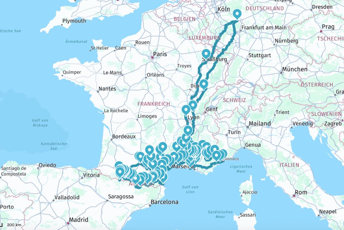
Planning trip: Luberon-Provence-Occitania-Pyrenees-Ardeche

Travelogue
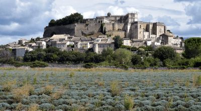
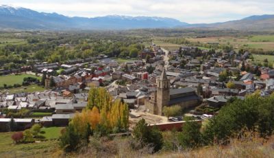
Château de Grignan: famous for its letters.
The town owes its fame to its magnificent Renaissance castle and the well-known letters that Madame de Sévigné (one of the classics of French literature) wrote to her daughter , Madame de Grignan, wrote in the 17th century.
Grignan is located in the south of the Drôme department near the Ventoux mountain.
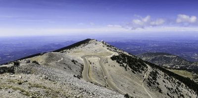
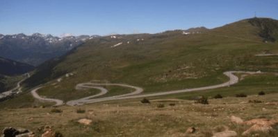
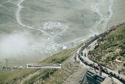
better known to cyclists as the "Pass of the Storms" or the Giant of Provence. The ascent is hardly difficult, the surface due to the many cycling events, mostly in perfect condition. The view and the experience of nature on the mountain are worthwhile. When the wind picks up here (the gusty Mistral blows over the bare mountain ranges), it's no longer fun.
Possibly. stay at the top of the parking lot ????
(unfortunately, the route does not take planning as a waypoint - there is a winter closure / from Malaucéne the road is often closed until mid-May, , and the access road is then often only to the winter sports area on Mont Serein.)
The village of Sault is perched on a rocky outcrop in a plain made up of fields of wheat, spelled and lavender.
Only 26 km from the top of Mont Ventoux.
The village of Sault is perched on a rocky outcrop in a plain made up of fields of wheat, spelled and lavender.
Only 26 km from the top of Mont Ventoux.
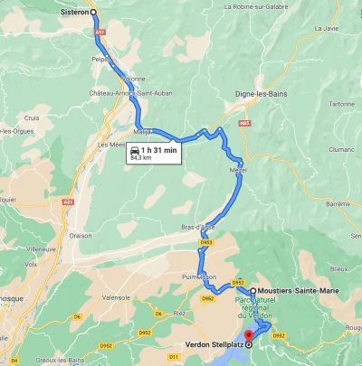
The Méouge gorge, described as the wonder of the Hautes-Alpes, is known for swimming and hiking. Classified as a biological reserve, it is one of the jewels of the Sisteron-Buëch area.
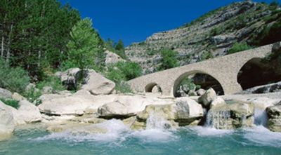
The Méouge gorge, described as the wonder of the Hautes-Alpes, is known for swimming and hiking. Classified as a biological reserve, it is one of the jewels of the Sisteron-Buëch area.
Sisteron is nicknamed "Gateway to Provence" (Porte de Provence); it is an important stop on the Napoléon route and also a frequent stage of the Tour de France.
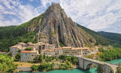
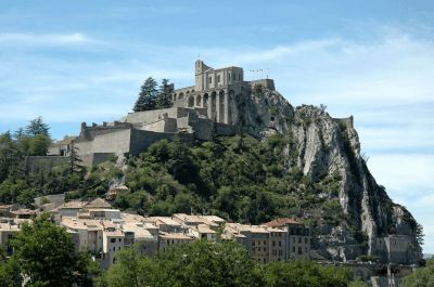
Sisteron is nicknamed "Gateway to Provence" (Porte de Provence); it is an important stop on the Napoléon route and also a frequent stage of the Tour de France.
3 parking spaces
3 parking spaces
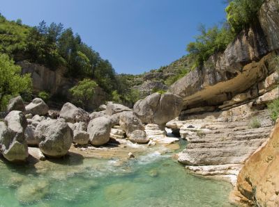
A clue is an almost closed passage between 2 rocks, mostly eroded by a river.
The clues de Barles were formed in a calcareous rod about 150 million years ago (late Jurassic and early Cretaceous) opened by the river Bès.
At the entrance of the gorges stands a strange stone sculpture. It is one of Andy Goldsworthy's "Guardians", modern artist, and belongs to his only Land'Art work "Refuges d'Art".
The mountain village is north of the Lac de Sainte-Croix reservoir and the entrance to the Verdon Gorge.
Moustiers has been home to pottery crafts since the Middle Ages. In the 17th century the technique of faience was adopted and the town became a center of faience production, which lasted until the 19th century.
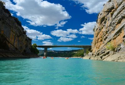
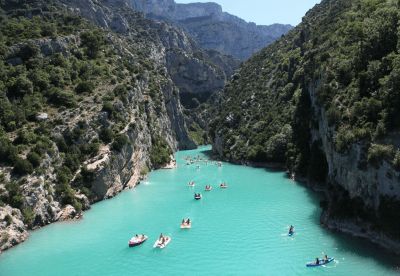
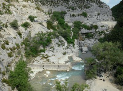
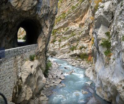
The Point Sublime is one of the most beautiful vantage points of the Verdon Gorges. It is located on the right bank of the river.
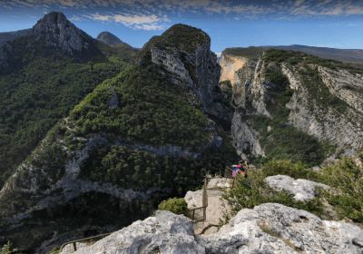
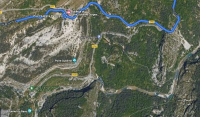
The Point Sublime is one of the most beautiful vantage points of the Verdon Gorges. It is located on the right bank of the river.
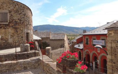
An exceptional medieval setting with access to the fortified city walls via a stone bridge.
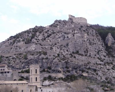
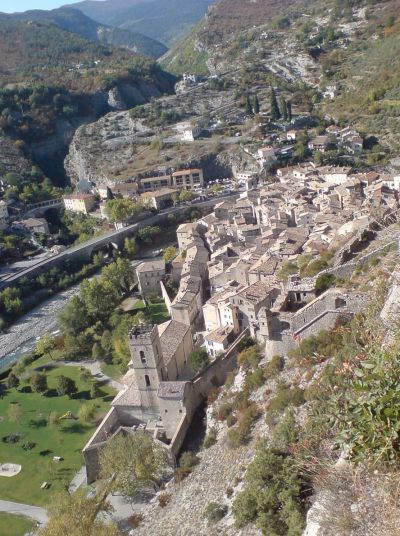
An exceptional medieval setting with access to the fortified city walls via a stone bridge.
The city was the birthplace of the post-impressionist painter Paul Cézanne. Today, a tour takes you past various stations in his life, including his childhood home.
The climate is Mediterranean with hot, dry summers and mild, sunny winters. The hills to the north (Luberon and Trévaresse) offer some protection from the dreaded mistral. The mean temperature varies between 6.5 °C in January and 24 °C in July.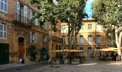
The village is located on the Mediterranean Sea, on the Côte Bleue.
It is best known for its old quarries and lighthouses. The quarries were already mentioned by the Greek Strabo. Excavations suggest that they were used as early as the 6th century BC.
The Cap Couronne is the most prominent headland between the Bay of Marseille and that of Fos-sur-Mer.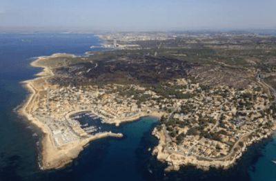
It has been classified as one of the Plus beaux villages de France (Most Beautiful Villages in France).
The château, former residence of the Sabran family (10th century). Originally built as a castle, remodeled in the 12th and 13th centuries, further remodeling in the 15th and 19th centuries. The current building dates from the 17th century and has two small garden parterres in baroque style.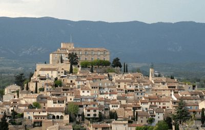
Eat great ice cream
Eat great ice cream
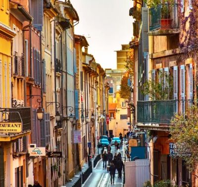
The small town of Apt is located in the Calavon valley between the Plateau de Vaucluse and the Luberon mountains. Even in Roman times there was a town that was then called Colonia Julia Apta and a Roman road, the Via Domitia, also passed here.
Today, Apt is known for its candied fruit.
The small town of Apt is located in the Calavon valley between the Plateau de Vaucluse and the Luberon mountains. Even in Roman times there was a town that was then called Colonia Julia Apta and a Roman road, the Via Domitia, also passed here.
Today, Apt is known for its candied fruit.
in the summer with about 350 dealers
in the summer with about 350 dealers
Véloroute du Calavon - on the track bed to the Roman stone arch bridge "Pont Julien"
Les Lavandiens in Bonnieux
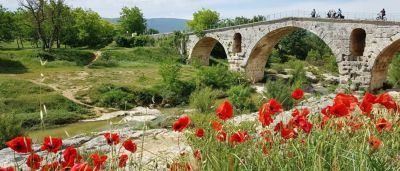
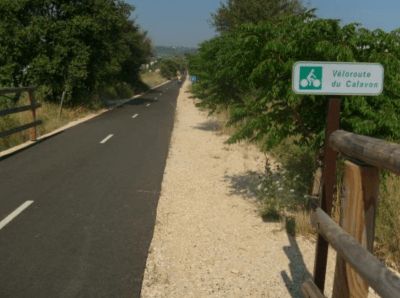
Véloroute du Calavon - on the track bed to the Roman stone arch bridge "Pont Julien"
Les Lavandiens in Bonnieux
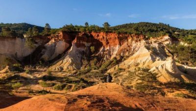
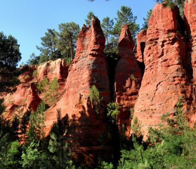
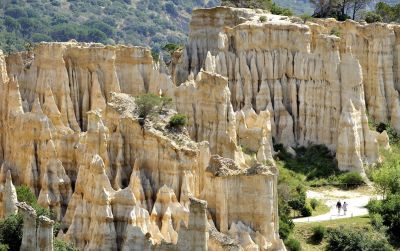
to the ocher cliffs of Rustrel - mother nature in a real flash of colour
The Colorado of Rustrel, also known as the American West in Provence.
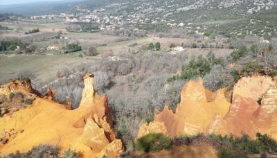
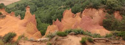
to the ocher cliffs of Rustrel - mother nature in a real flash of colour
The Colorado of Rustrel, also known as the American West in Provence.
Parking space at the ocher quarries / Le Colorado Provence
Parking space at the ocher quarries / Le Colorado Provence
About 1 km from the Sentier des Ocres
About 1 km from the Sentier des Ocres
You can admire the ocher cliffs in Provence either in Roussillon or about 15 km further east at Rustrel. Both areas can also be covered in one day.
In Roussillon, the ocher quarries can be hiked via the famous "Sentier des Ocres".
You can admire the ocher cliffs in Provence either in Roussillon or about 15 km further east at Rustrel. Both areas can also be covered in one day.
In Roussillon, the ocher quarries can be hiked via the famous "Sentier des Ocres".
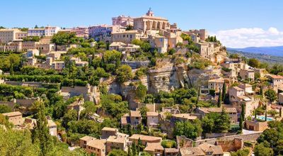
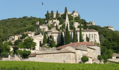
The typical picture book village. The well-known Hollywood film "A Good Year" was filmed here, and the silhouette of the place (certainly the most beautiful in Provence) can be found on many postcards accordingly, it has been developed for tourism and is also overcrowded (well over 1 million visitors/year! )

The typical picture book village. The well-known Hollywood film "A Good Year" was filmed here, and the silhouette of the place (certainly the most beautiful in Provence) can be found on many postcards accordingly, it has been developed for tourism and is also overcrowded (well over 1 million visitors/year! )
Such a photo can only be taken in a very short time window at the beginning of June, after which the lavender is harvested.
Notre-Dame de Sénanque is a monastery of the Cistercian order in the territory of the municipality of Gordes
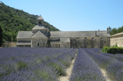
Such a photo can only be taken in a very short time window at the beginning of June, after which the lavender is harvested.
Notre-Dame de Sénanque is a monastery of the Cistercian order in the territory of the municipality of Gordes
L'Isle-sur-la-Sorgue - The old town is a tip for antique lovers.
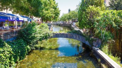
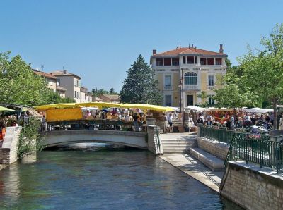
L'Isle-sur-la-Sorgue - The old town is a tip for antique lovers.
The Tourist Office lists current event dates
The Tourist Office lists current event dates
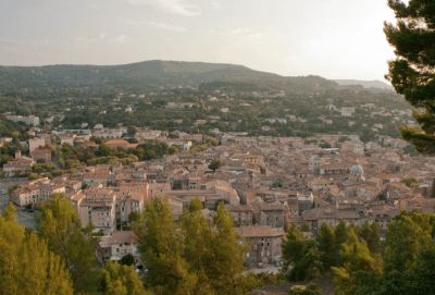
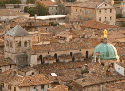
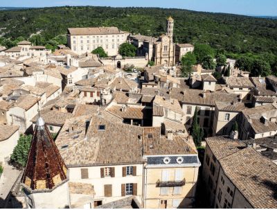
The old town with the Gothic papal palace (Palais des Papes) from the 14th century, the bishop's complex, the Rocher des Doms and the famous bridge, the Pont Saint-Bénézet, is a UNESCO World Heritage Site .
1st picture: Historical center around the Papal Palace
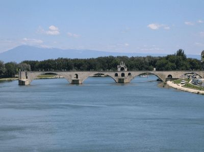
2nd picture: The Pont d'Avignon on the "little Rhône", in the background the Mont Ventoux
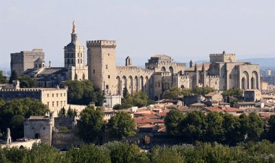
The old town with the Gothic papal palace (Palais des Papes) from the 14th century, the bishop's complex, the Rocher des Doms and the famous bridge, the Pont Saint-Bénézet, is a UNESCO World Heritage Site .
1st picture: Historical center around the Papal Palace
2nd picture: The Pont d'Avignon on the "little Rhône", in the background the Mont Ventoux
Orange in France: A journey through time to Provence in antiquity. The triumphal arch of Orange was built in the 1st century.
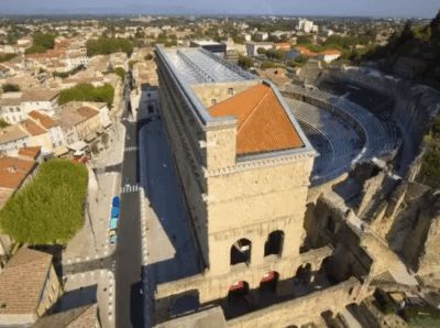
It is the fact that the Romans left unmistakable traces here, as in so many places in Provence. An excellently preserved theater invites you to visit.
In 1981 these buildings were included in the list of World Heritage Sites by UNESCO.
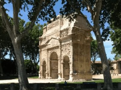
Orange in France: A journey through time to Provence in antiquity. The triumphal arch of Orange was built in the 1st century.
It is the fact that the Romans left unmistakable traces here, as in so many places in Provence. An excellently preserved theater invites you to visit.
In 1981 these buildings were included in the list of World Heritage Sites by UNESCO.
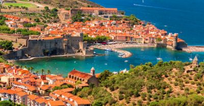
Rated among the most beautiful villages in France, La Roque-sur-Cèze is one of the jewels of the Gard.
Rated among the most beautiful villages in France, La Roque-sur-Cèze is one of the jewels of the Gard.
The Sautadet cascades are gorges and waterfalls in the Cèze river. These natural waterfalls and whirlpools, which have dug themselves into the white limestone over a width of more than 500 meters, are an impressive and also very loud natural spectacle

The Sautadet cascades are gorges and waterfalls in the Cèze river. These natural waterfalls and whirlpools, which have dug themselves into the white limestone over a width of more than 500 meters, are an impressive and also very loud natural spectacle
Uzès is a cozy town with many undiscovered sights.
Uzès is a cozy town with many undiscovered sights.
The Pont du Gard is a Roman aqueduct in the south of France in the commune of Vers-Pont-du-Gard.
The bridge is of impressive height and is one of the best preserved Roman water canals in France.
The aqueduct Pont du Gard was included in the UNESCO list in 1985 - World Heritage added.
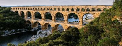
The Pont du Gard is a Roman aqueduct in the south of France in the commune of Vers-Pont-du-Gard.
The bridge is of impressive height and is one of the best preserved Roman water canals in France.
The aqueduct Pont du Gard was included in the UNESCO list in 1985 - World Heritage added.
Nîmes was founded in the 6th century BC. founded and 120 BC. occupied by the Romans.
The Roman rulers left the city a rich legacy that has survived to this day and has earned it the title "Ancient History in the Present".
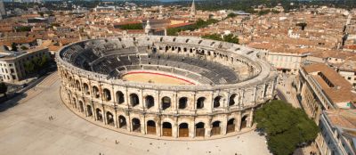
Nîmes was founded in the 6th century BC. founded and 120 BC. occupied by the Romans.
The Roman rulers left the city a rich legacy that has survived to this day and has earned it the title "Ancient History in the Present".
Arles is a city on the banks of the Rhone River in the Provence region of southern France. It is famous as a source of inspiration for Van Gogh's paintings.
Arles was once the provincial capital of the Roman Empire and is also known for the many remains from that period, including the Arles amphitheater, which today hosts theatrical performances, concerts and bullfights take place.
Under the designation "Roman and Romanesque Monuments of Arles", UNESCO summarizes seven monuments in the municipality.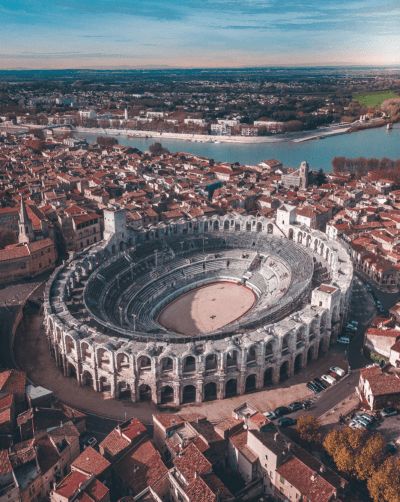
Parking space on the Rhone, from there about 2 km walk to the city
Parking space on the Rhone, from there about 2 km walk to the city
Aigues-Mortes is a cute little town known for its salt flats, pink flamingos and charming old town. The old town dates back to the 13th century when Louis IX, the city's founder, had a port built.
The salt lakes produce 500,000 tons of salt a year and are home to the Fleur de Sel
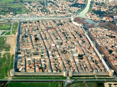
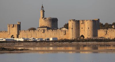
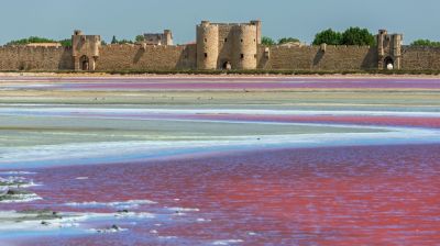
Aigues-Mortes is a cute little town known for its salt flats, pink flamingos and charming old town. The old town dates back to the 13th century when Louis IX, the city's founder, had a port built.
The salt lakes produce 500,000 tons of salt a year and are home to the Fleur de Sel
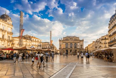
Montpellier in the south of France has developed over the years into a city that can compete with international metropolises.
Montpellier was 1349 by King James III. of Mallorca to the French king Philip VI. sold by France to fill the war chest in the fight against Peter IV of Aragon to reconquer Mallorca.
Olargues is located in the Jaur
valley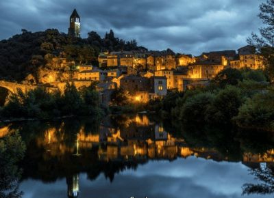
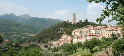
Olargues is located in the Jaur
valleyfrom there about 2 km walk to the city
from there about 2 km walk to the city

approx. 3 km walk to the Palace of the Kings
approx. 3 km walk to the Palace of the Kings
Quéribus Castle is commonly considered a Cathar castle and was later a French fortress in the former border area with the Kingdom of Aragon and Spain.
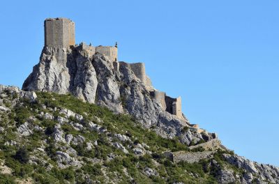
Quéribus Castle is commonly considered a Cathar castle and was later a French fortress in the former border area with the Kingdom of Aragon and Spain.
Short hike from parking lot
possibly Parking for sightseeing ???
possibly Parking for sightseeing ???
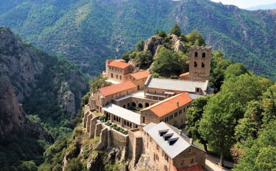
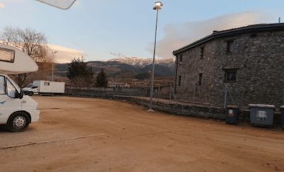
Address: Route de Saint-Michel, Codalet, France
(nice pitch....!!!)
Address: Route de Saint-Michel, Codalet, France
(nice pitch....!!!)
The Abbey of Saint-Michel-de-Cuxa is one of the oldest Benedictine monasteries in the French Pyrenees. It is at 430 m altitude at the foot of Canigou
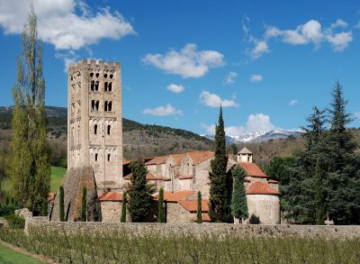
The Abbey of Saint-Michel-de-Cuxa is one of the oldest Benedictine monasteries in the French Pyrenees. It is at 430 m altitude at the foot of Canigou
with the Le Petit Train Jaune (the little yellow train) or the "Canari" (canary)
departure in the morning at 9.37 a.m. from Villefranche and back at 4.17 p.m. or 5.13 p.m., then you have 5/6 hrs to see the Mont-Louis Solar Furnace and Fort Mont Louis.
with the Le Petit Train Jaune (the little yellow train) or the "Canari" (canary)
departure in the morning at 9.37 a.m. from Villefranche and back at 4.17 p.m. or 5.13 p.m., then you have 5/6 hrs to see the Mont-Louis Solar Furnace and Fort Mont Louis.
The Abbey of Saint-Martin-du-Canigou is 1094 meters high on the western slope, just under halfway up the 2785-metre-high Pic du Canigou in the French Pyrenees.
The Abbey of Saint-Martin-du-Canigou is 1094 meters high on the western slope, just under halfway up the 2785-metre-high Pic du Canigou in the French Pyrenees.
After Saillagouse, we turn off the national road and make a short detour to a Catalan enclave on French soil that has been around for more than 300 years.
The Treaty of the Pyrenees in 1659 established new borders for the kingdoms of France and Spain. Since then there has been this enclave on the Cerdagne plateau (Cerdanya).
It is also possible to take the "Kanari" up here.
The pass is the watershed between the Atlantic and the Mediterranean
There is an RV park at the top of the pass: Aparcamiento de autocaravanas Puerto d'Envalira

The pass is the watershed between the Atlantic and the Mediterranean
There is an RV park at the top of the pass: Aparcamiento de autocaravanas Puerto d'Envalira
Pitch: Aparcament Autocaravanes Port d'Envalira
Pitch: Aparcament Autocaravanes Port d'Envalira
can also be used as a camper place
can also be used as a camper place
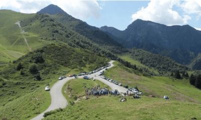
Mountain pass in the Spanish Pyrenees
Mountain pass in the Central Pyrenees
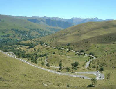
The Col de Peyresourde was the first pass crossed in the 1910 Tour de France and has been included in this cycling race 62 times to date.
< /p>
Mountain pass in the Central Pyrenees
The Col de Peyresourde was the first pass crossed in the 1910 Tour de France and has been included in this cycling race 62 times to date.
< /p>
The road via de Col de Val Louron-Azet connects
St. Lary-Soulan to the west with Loudenvielle to the east.
The road via de Col de Val Louron-Azet connects
St. Lary-Soulan to the west with Loudenvielle to the east.
The pass is in the Occitania region.
It connects Bagnères-de-Bigorre or Sainte-Marie-de-Campan in the Campan Valley to Arreau in the Aure Valley.

The pass is in the Occitania region.
It connects Bagnères-de-Bigorre or Sainte-Marie-de-Campan in the Campan Valley to Arreau in the Aure Valley.
according to many Tour de France reporters - the highest paved road pass (2115 m) in the Pyrenees - winter closure from December to May
but not true: the Port d'Envalira is the highest at 2407 m and it is not closed in winter
according to many Tour de France reporters - the highest paved road pass (2115 m) in the Pyrenees - winter closure from December to May
but not true: the Port d'Envalira is the highest at 2407 m and it is not closed in winter
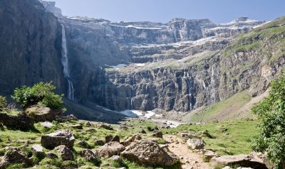
a basin with one of the highest waterfalls in Europe
about 5 km on foot there and back (about 500 meters in altitude)
a basin with one of the highest waterfalls in Europe
about 5 km on foot there and back (about 500 meters in altitude)
at the cemetery
at the cemetery
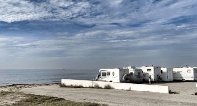
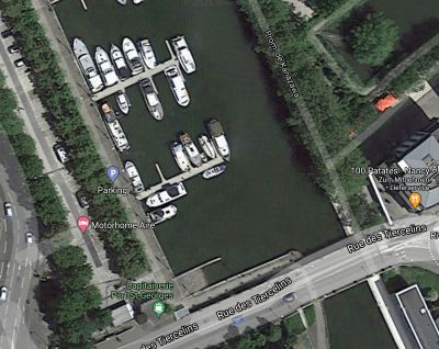
Parking / Motorhome Aire
Parking / Motorhome Aire
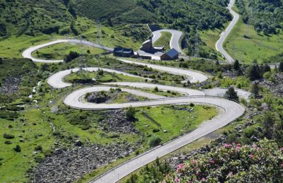
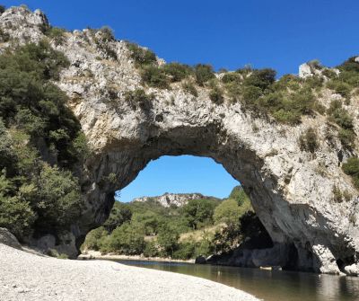
The viaduct was designed by Michel Virlogeux and designed by Norman Foster. At 2460 m, the viaduct is the longest cable-stayed bridge in the world and, with a maximum pillar height of 343 m, the tallest structure in France. The bridge is subject to a toll.
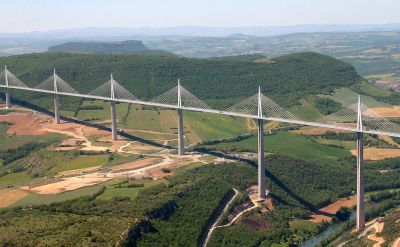
The viaduct was designed by Michel Virlogeux and designed by Norman Foster. At 2460 m, the viaduct is the longest cable-stayed bridge in the world and, with a maximum pillar height of 343 m, the tallest structure in France. The bridge is subject to a toll.
Route
Show newest first- 50.552 8.4165
- 50° 33' 7.1" N 8° 24' 59.4" E
- 47.2378 6.0241
- 47° 14' 16.2" N 6° 1' 26.6" E
- 46.2092 5.2399
- 46° 12' 33.1" N 5° 14' 23.8" E
- 46.1986 5.2378
- 46° 11' 54.8" N 5° 14' 16.2" E
- 44.4195 4.9094
- 44° 25' 10.2" N 4° 54' 34" E
- 44.4174 4.9093
- 44° 25' 2.5" N 4° 54' 33.3" E
- 44.4113 4.901
- 44° 24' 40.5" N 4° 54' 3.6" E
- 44.178 5.1253
- 44° 10' 40.8" N 5° 7' 31" E
besser bekannt für Fahrradfahrer unter dem Namen „Pass der Stürme“ oder der Riese der Provence. Die Auffahrt ist kaum schwierig, der Belag auf Grund der vielen Radsportveranstaltungen, meist in tadellosem Zustand. Lohnenswert sind die Aussicht und das Naturerlebnis am Berg. Wenn hier Wind aufkommt (der böige Mistral fegt über die kahlen Höhenzüge), ist das bald kein Spaß mehr.
Evtl. oben auf dem Parkplatz übernachten ????
(die Route nimmt die Planung leider nicht als Wegepunkt - es gibt eine Wintersperre / Von Malaucéne aus ist die Straße oft bis Mitte Mai gesperrt, und die Zufahrt geht dann oft nur bis zum Wintersportgebiet am Mont Serein.)
- 44.0914 5.4082
- 44° 5' 29.1" N 5° 24' 29.4" E
- 44.0914 5.4082
- 44° 5' 29.1" N 5° 24' 29.4" E
Das Dorf Sault liegt auf einem Felsvorsprung in einer Ebene, die aus Weizen-, Dinkel- und Lavendelfeldern besteht.
Nur 26 km von der Spitze des Mont Ventoux entfernt.
Die Schlucht der Méouge, die als Wunder der Hautes-Alpes bezeichnet wird, ist fürs Schwimmen und Wandern bekannt. Sie wurde als biologisches Reservat eingestuft und gehört zu den Juwelen des Sisteron-Buëch Gebiets.
- 44.1947 5.9432
- 44° 11' 41" N 5° 56' 35.5" E
- 44.2 5.9442
- 44° 12' 0" N 5° 56' 39" E
- 44.0922 6.236
- 44° 5' 31.9" N 6° 14' 9.5" E
Eine clue ist ein fast geschlossener Durchgang zwischen 2 Felsen, der meistens von einem Fluss erodiert wurde.
Die clues de Barles wurden in einer kalkhaltigen Stange vor ungefähr 150 Millionen Jahren (Ende des Jura und Anfang der Kreidezeit) von dem Fluss Bès geöffnet.
Am Eingang der Schluchten steht eine seltsame Stein Skulptur. Es handelt sich um einen der “Wächter” von Andy Goldsworthy, moderner Künstler, und gehört zu seinem einzigem Land’Art Kunstwerk “Refuges d’Art”.
- 43.8457 6.2215
- 43° 50' 44.5" N 6° 13' 17.3" E
- 43.8436 6.2186
- 43° 50' 37" N 6° 13' 7" E
- 43.8016 6.2495
- 43° 48' 5.7" N 6° 14' 58" E
- 43.8009 6.2478
- 43° 48' 3.3" N 6° 14' 52.1" E
- 43.7777 6.2139
- 43° 46' 39.6" N 6° 12' 50.1" E
- 43.7795 6.3418
- 43° 46' 46.2" N 6° 20' 30.6" E
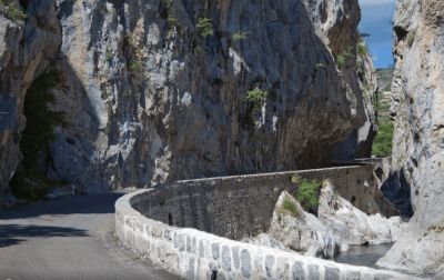
Der Point Sublime ist einer der schönsten Aussichtspunkte auf die Verdon-Schlucht. Er befindet sich auf der rechten Uferseite des Flusses.
- 43.9162 6.5404
- 43° 54' 58.3" N 6° 32' 25.4" E
- 43.9502 6.81
- 43° 57' 0.9" N 6° 48' 36.2" E
- 43.9489 6.8142
- 43° 56' 56.1" N 6° 48' 51.2" E
- 43.7308 7.4226
- 43° 43' 50.9" N 7° 25' 21.3" E
- 43.7326 7.4178
- 43° 43' 57.3" N 7° 25' 3.9" E
- 43.7232 7.396
- 43° 43' 23.4" N 7° 23' 45.6" E
- 43.6662 7.1944
- 43° 39' 58.2" N 7° 11' 39.7" E
- 43.6487 6.9311
- 43° 38' 55.2" N 6° 55' 51.9" E
- 43.5297 5.4474
- 43° 31' 47.1" N 5° 26' 50.7" E
- 43.3367 5.0564
- 43° 20' 12.1" N 5° 3' 23.2" E
- 43.513 4.988
- 43° 30' 46.8" N 4° 59' 16.7" E
- 43.6402 5.097
- 43° 38' 24.7" N 5° 5' 49.3" E
- 43.7427 5.5099
- 43° 44' 33.8" N 5° 30' 35.6" E
- 43.7635 5.3626
- 43° 45' 48.5" N 5° 21' 45.3" E
- 43.8765 5.3954
- 43° 52' 35.2" N 5° 23' 43.6" E
- 43.8765 5.3954
- 43° 52' 35.2" N 5° 23' 43.6" E
im Sommer mit etwa 350 Händlern
Véloroute du Calavon - im Gleisbett zur römischen Steinbogen- Brücke "Pont Julien"
Les Lavandiens in Bonnieux
- 43.8625 5.3066
- 43° 51' 45.1" N 5° 18' 23.7" E
- 43.8804 5.3162
- 43° 52' 49.3" N 5° 18' 58.3" E
- 43.9245 5.4845
- 43° 55' 28.3" N 5° 29' 4.2" E
- 43.9197 5.4996
- 43° 55' 10.8" N 5° 29' 58.6" E
- 43.9023 5.2929
- 43° 54' 8.3" N 5° 17' 34.6" E
- 43.8804 5.2896
- 43° 52' 49.5" N 5° 17' 22.7" E
Die Ockerfelsen in der Provence können Sie entweder in Roussillon bewundern oder etwa 15 km weiter östlich bei Rustrel. Es sind auch beide Gebiete an einem Tag zu schaffen.
In Roussillon sind die Ockerbrüche über den berühmten “Sentier des Ocres” zu erwandern.
- 43.9113 5.2002
- 43° 54' 40.7" N 5° 12' 0.6" E
Ein solches Foto ist nur in einem sehr kurzen Zeitfenster Anfang Juni zu machen, danach ist der Lavendel abgeerntet.
Notre-Dame de Sénanque ist ein Kloster des Zisterzienserordens auf dem Gebiet der Gemeinde Gordes
- 43.9142 5.0571
- 43° 54' 51.1" N 5° 3' 25.6" E
aktuelle Veranstaltungstermine listet das Fremdenverkehrsamt auf
- 44.1381 4.8075
- 44° 8' 17.2" N 4° 48' 27" E
- 44.1934 4.5184
- 44° 11' 36.1" N 4° 31' 6.4" E
- 44.1959 4.5227
- 44° 11' 45.3" N 4° 31' 21.6" E
Die Kaskaden von Sautadet sind Schluchten und Wasserfälle im Flusslauf der Cèze. Diese natürlichen Wasserfälle und Strudel, die sich auf einer Breite von über 500 Metern in den weißen Kalkstein gegraben haben, sind ein eindrucksvolles und auch sehr lautes Naturschauspiel
- 44.0121 4.4199
- 44° 0' 43.6" N 4° 25' 11.8" E
- 43.9495 4.5425
- 43° 56' 58" N 4° 32' 32.9" E
Der Pont du Gard ist ein römischer Aquädukt im Süden Frankreichs auf dem Gebiet der Gemeinde Vers-Pont-du-Gard.
Die Brücke ist von beeindruckender Höhe und stellt einen der am besten erhaltenen Wasserkanäle aus der Römerzeit in Frankreich dar.
Der Aquädukt Pont du Gard wurde 1985 in die Liste des UNESCO-Welterbes aufgenommen.
- 43.8757 4.2774
- 43° 52' 32.6" N 4° 16' 38.5" E
- 43.6763 4.6145
- 43° 40' 34.5" N 4° 36' 52.4" E
- 43.677 4.4322
- 43° 40' 37.2" N 4° 25' 56" E
- 43.5672 4.1926
- 43° 34' 1.8" N 4° 11' 33.3" E
- 43.5664 4.1858
- 43° 33' 59" N 4° 11' 9" E
- 43.5672 4.1926
- 43° 34' 1.8" N 4° 11' 33.3" E
- 43.6108 3.8767
- 43° 36' 38.8" N 3° 52' 36.2" E
- 43.5894 3.9019
- 43° 35' 21.7" N 3° 54' 6.8" E
- 43.3667 3.6161
- 43° 22' 0" N 3° 36' 58" E
- 43.4605 3.4142
- 43° 27' 37.7" N 3° 24' 51.1" E
- 43.5567 2.9137
- 43° 33' 24.1" N 2° 54' 49.4" E
- 43.5564 2.9189
- 43° 33' 23" N 2° 55' 8" E
- 43.3442 3.2158
- 43° 20' 39.2" N 3° 12' 56.9" E
- 43.3317 3.1918
- 43° 19' 54.1" N 3° 11' 30.4" E
- 43.1843 3.0031
- 43° 11' 3.4" N 3° 0' 11.1" E
- 43.1806 3.0228
- 43° 10' 50" N 3° 1' 22" E
- 42.8565 3.041
- 42° 51' 23.5" N 3° 2' 27.5" E
- 42.8995 3.0538
- 42° 53' 58.1" N 3° 3' 13.6" E
- 42.5185 3.1066
- 42° 31' 6.6" N 3° 6' 23.7" E
- 42.5175 3.109
- 42° 31' 3" N 3° 6' 32.5" E
- 42.6887 2.8948
- 42° 41' 19.2" N 2° 53' 41.4" E
- 42.7091 2.9048
- 42° 42' 32.7" N 2° 54' 17.2" E
ca. 3 km zu Fuß zum Palast der Könige
- 42.8368 2.6215
- 42° 50' 12.4" N 2° 37' 17.4" E
Die Burg Quéribus zählt gemeinhin zu den Katharerburgen und war in späterer Zeit eine Feste Frankreichs im ehemaligen Grenzgebiet zum Königreich Aragón und zu Spanien.
- 42.671 2.6213
- 42° 40' 15.6" N 2° 37' 16.5" E
kurze Wanderung vom Parkplatz
- 42.6193 2.4173
- 42° 37' 9.5" N 2° 25' 2.3" E
- 42.6213 2.4229
- 42° 37' 16.7" N 2° 25' 22.3" E
Adresse: Route de Saint-Michel, Codalet, Frankreich
(schöner Stellplatz ....!!!)
Die Abtei Saint-Michel-de-Cuxa ist eines der ältesten Benediktinerklöster in den französischen Pyrenäen. Sie liegt in 430 m Höhe am Fuße des Canigou
- 42.5868 2.3665
- 42° 35' 12.3" N 2° 21' 59.5" E
mit dem Le Petit Train Jaune (der kleine gelbe Zug) oder auch der "Canari" (Kanarienvogel)
Abfahrt am besten Morgens um 9.37 Uhr von Villefranche und um 16.17 Uhr oder um 17.13 Uhr zurück, dann hat man 5/6 Std. Zeit um sich den Mont-Louis Solar Furnace (Sonnenofen) und das Fort Mont Louis anzusehen.
Die Abtei Saint-Martin-du-Canigou liegt 1094 Meter hoch am Westhang in knapp halber Höhe des 2785 Meter hohen Pic du Canigou in den französischen Pyrenäen.
- 42.533 2.3929
- 42° 31' 58.9" N 2° 23' 34.4" E
- 42.4579 2.0387
- 42° 27' 28.4" N 2° 2' 19.3" E
nach Saillagouse biegen wir von der Nationalstraße ab und machen einen kurzen Abstecher zu einer, seit mehr als 300 Jahren alten katalanische Enklave auf französischem Boden.
Der Pyrenäenvertrag legte im Jahr 1659 neue Grenzen für die Königreiche Frankreich und Spanien fest. Seit dem gibt es auf der Hochebene Cerdagne (Cerdanya) diese Enklave.
Es besteht auch die Möglichkeit mit dem "Kanari" bis hierher zu fahren.
- 42.4634 1.9802
- 42° 27' 48.2" N 1° 58' 48.7" E
- 42.5422 1.7326
- 42° 32' 31.9" N 1° 43' 57.3" E
Der Pass ist die Wasserscheide zwischen Atlantik und Mittelmeer
Oben am Pass gibt es einen Wohnmobilstellplatz: Aparcamiento de autocaravanas Puerto d'Envalira
Stellplatz: Aparcament Autocaravanes Port d'Envalira
- 42.5063 1.5218
- 42° 30' 22.7" N 1° 31' 18.6" E
- 42.3576 1.4556
- 42° 21' 27.3" N 1° 27' 20" E
- 42.3589 1.4644
- 42° 21' 32" N 1° 27' 52" E
- 42.4429 1.1347
- 42° 26' 34.5" N 1° 8' 4.9" E
- 42.4394 1.1342
- 42° 26' 22" N 1° 8' 3.2" E
Gebirgspass in den spanischen Pyrenäen
- 42.707 0.901
- 42° 42' 25.3" N 0° 54' 3.7" E
- 42.703 0.7932
- 42° 42' 10.8" N 0° 47' 35.7" E
- 42.789 0.5929
- 42° 47' 20.3" N 0° 35' 34.6" E
- 42.795 0.5983
- 42° 47' 42" N 0° 35' 54" E
Gebirgspass in den Zentral-Pyrenäen
Der Col de Peyresourde war der erste Pass, der bei der Tour de France 1910 überquert wurde und wurde bisher 62-mal in dieses Radrennen einbezogen.
- 42.8018 0.4109
- 42° 48' 6.4" N 0° 24' 39.2" E
Die Straße über de Col de Val Louron-Azet verbindet
St. Lary-Soulan im Westen mit Loudenvielle im Osten.
- 42.8113 0.3515
- 42° 48' 40.8" N 0° 21' 5.2" E
- 42.8185 0.3222
- 42° 49' 6.6" N 0° 19' 19.8" E
- 42.905 0.3593
- 42° 54' 17.8" N 0° 21' 33.3" E
- 42.9042 0.3562
- 42° 54' 15.3" N 0° 21' 22.3" E
Der Pass befindet sich in der Region Okzitanien.
Er verbindet Bagnères-de-Bigorre bzw. Sainte-Marie-de-Campan im Campan-Tal mit Arreau im Aure-Tal.
- 42.9302 0.2023
- 42° 55' 48.7" N 0° 12' 8.4" E
lt. vieler Tour de France Reporter - der höchste asphaltierte Straßenpass (2115 m) in den Pyrenäen - Wintersperre von Dez. bis Mai
stimmt aber nicht: der Port d'Envalira ist der höchste mit 2407 m und er hat keine Wintersperre
- 42.8965 0.0645
- 42° 53' 47.6" N 0° 3' 52.3" E
- 42.8735 -0.0029
- 42° 52' 24.8" N 0° 0' 10.3" W
- 42.8604 -0.0077
- 42° 51' 37.4" N 0° 0' 27.7" W
- 42.7864 0.0193
- 42° 47' 11.1" N 0° 1' 9.5" E
- 42.7277 -0.0076
- 42° 43' 39.6" N 0° 0' 27.2" W
ein Talkessel mit einem der höchsten Wasserfälle Europas
ca 5 km zu Fuß hin und auch wieder zurück (ungefähr 500 Höhenmeter)
- 43.0915 -0.0457
- 43° 5' 29.3" N 0° 2' 44.6" W
- 43.0883 -0.0527
- 43° 5' 18" N 0° 3' 9.6" W
- 43.0984 -0.0417
- 43° 5' 54.2" N 0° 2' 30.3" W
- 43.6047 1.4442
- 43° 36' 16.7" N 1° 26' 39.2" E
- 43.5886 1.4912
- 43° 35' 18.9" N 1° 29' 28.2" E
- 43.3171 1.9533
- 43° 19' 1.6" N 1° 57' 12" E
- 43.3141 1.9491
- 43° 18' 50.8" N 1° 56' 56.6" E
- 43.4586 2.0046
- 43° 27' 31" N 2° 0' 16.5" E
- 43.4544 2.0153
- 43° 27' 16" N 2° 0' 55" E
- 43.2132 2.3518
- 43° 12' 47.6" N 2° 21' 6.4" E
- 43.2003 2.3535
- 43° 12' 1.2" N 2° 21' 12.6" E
- 43.2054 2.3731
- 43° 12' 19.5" N 2° 22' 23.2" E
- 43.6062 2.2413
- 43° 36' 22.4" N 2° 14' 28.7" E
- 43.9251 2.1486
- 43° 55' 30.3" N 2° 8' 55.1" E
- 43.9311 2.1361
- 43° 55' 51.9" N 2° 8' 9.8" E
- 43.9292 2.1352
- 43° 55' 45.2" N 2° 8' 6.6" E
- 43.9582 2.8871
- 43° 57' 29.5" N 2° 53' 13.7" E
Das Viadukt wurde von Michel Virlogeux entworfen und von Norman Foster gestalterisch ausgearbeitet.Das Viadukt ist mit 2460 m die längste Schrägseilbrücke der Welt und bei einer maximalen Pfeilerhöhe von 343 m das höchste Bauwerk Frankreichs. Die Brücke ist mautpflichtig.
- 44.1006 3.0778
- 44° 6' 2.1" N 3° 4' 40.1" E
- 44.0958 3.0858
- 44° 5' 45" N 3° 5' 9" E
- 44.1272 4.0834
- 44° 7' 37.9" N 4° 5' 0.1" E
- 44.12 4.0825
- 44° 7' 12" N 4° 4' 57" E
- 44.4075 4.3954
- 44° 24' 26.8" N 4° 23' 43.4" E
- 44.3755 4.4207
- 44° 22' 31.8" N 4° 25' 14.7" E
- 44.3057 4.5795
- 44° 18' 20.7" N 4° 34' 46" E
- 44.5649 4.7565
- 44° 33' 53.5" N 4° 45' 23.6" E
- 44.9334 4.8924
- 44° 56' 0.2" N 4° 53' 32.5" E
- 45.9724 4.7517
- 45° 58' 20.5" N 4° 45' 6.3" E
- 48.6921 6.1844
- 48° 41' 31.4" N 6° 11' 3.9" E
- 48.693 6.192
- 48° 41' 34.8" N 6° 11' 31.3" E
- 50.552 8.4165
- 50° 33' 7.1" N 8° 24' 59.4" E
Travelogue
Château de Grignan: famous for its letters.
The town owes its fame to its magnificent Renaissance castle and the well-known letters that Madame de Sévigné (one of the classics of French literature) wrote to her daughter , Madame de Grignan, wrote in the 17th century.
Grignan is located in the south of the Drôme department near the Ventoux mountain.
better known to cyclists as the "Pass of the Storms" or the Giant of Provence. The ascent is hardly difficult, the surface due to the many cycling events, mostly in perfect condition. The view and the experience of nature on the mountain are worthwhile. When the wind picks up here (the gusty Mistral blows over the bare mountain ranges), it's no longer fun.
Possibly. stay at the top of the parking lot ????
(unfortunately, the route does not take planning as a waypoint - there is a winter closure / from Malaucéne the road is often closed until mid-May, , and the access road is then often only to the winter sports area on Mont Serein.)
The village of Sault is perched on a rocky outcrop in a plain made up of fields of wheat, spelled and lavender.
Only 26 km from the top of Mont Ventoux.
The village of Sault is perched on a rocky outcrop in a plain made up of fields of wheat, spelled and lavender.
Only 26 km from the top of Mont Ventoux.
The Méouge gorge, described as the wonder of the Hautes-Alpes, is known for swimming and hiking. Classified as a biological reserve, it is one of the jewels of the Sisteron-Buëch area.
The Méouge gorge, described as the wonder of the Hautes-Alpes, is known for swimming and hiking. Classified as a biological reserve, it is one of the jewels of the Sisteron-Buëch area.
Sisteron is nicknamed "Gateway to Provence" (Porte de Provence); it is an important stop on the Napoléon route and also a frequent stage of the Tour de France.
Sisteron is nicknamed "Gateway to Provence" (Porte de Provence); it is an important stop on the Napoléon route and also a frequent stage of the Tour de France.
3 parking spaces
3 parking spaces
A clue is an almost closed passage between 2 rocks, mostly eroded by a river.
The clues de Barles were formed in a calcareous rod about 150 million years ago (late Jurassic and early Cretaceous) opened by the river Bès.
At the entrance of the gorges stands a strange stone sculpture. It is one of Andy Goldsworthy's "Guardians", modern artist, and belongs to his only Land'Art work "Refuges d'Art".
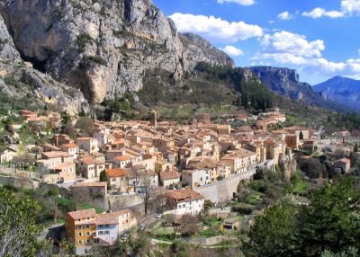
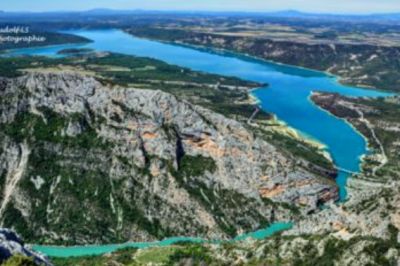
The mountain village is north of the Lac de Sainte-Croix reservoir and the entrance to the Verdon Gorge.
Moustiers has been home to pottery crafts since the Middle Ages. In the 17th century the technique of faience was adopted and the town became a center of faience production, which lasted until the 19th century.
The Point Sublime is one of the most beautiful vantage points of the Verdon Gorges. It is located on the right bank of the river.
The Point Sublime is one of the most beautiful vantage points of the Verdon Gorges. It is located on the right bank of the river.
An exceptional medieval setting with access to the fortified city walls via a stone bridge.
An exceptional medieval setting with access to the fortified city walls via a stone bridge.
The city was the birthplace of the post-impressionist painter Paul Cézanne. Today, a tour takes you past various stations in his life, including his childhood home.
The climate is Mediterranean with hot, dry summers and mild, sunny winters. The hills to the north (Luberon and Trévaresse) offer some protection from the dreaded mistral. The mean temperature varies between 6.5 °C in January and 24 °C in July.
The village is located on the Mediterranean Sea, on the Côte Bleue.
It is best known for its old quarries and lighthouses. The quarries were already mentioned by the Greek Strabo. Excavations suggest that they were used as early as the 6th century BC.
The Cap Couronne is the most prominent headland between the Bay of Marseille and that of Fos-sur-Mer.
It has been classified as one of the Plus beaux villages de France (Most Beautiful Villages in France).
The château, former residence of the Sabran family (10th century). Originally built as a castle, remodeled in the 12th and 13th centuries, further remodeling in the 15th and 19th centuries. The current building dates from the 17th century and has two small garden parterres in baroque style.
Eat great ice cream
Eat great ice cream
The small town of Apt is located in the Calavon valley between the Plateau de Vaucluse and the Luberon mountains. Even in Roman times there was a town that was then called Colonia Julia Apta and a Roman road, the Via Domitia, also passed here.
Today, Apt is known for its candied fruit.
The small town of Apt is located in the Calavon valley between the Plateau de Vaucluse and the Luberon mountains. Even in Roman times there was a town that was then called Colonia Julia Apta and a Roman road, the Via Domitia, also passed here.
Today, Apt is known for its candied fruit.
in the summer with about 350 dealers
in the summer with about 350 dealers
Véloroute du Calavon - on the track bed to the Roman stone arch bridge "Pont Julien"
Les Lavandiens in Bonnieux
Véloroute du Calavon - on the track bed to the Roman stone arch bridge "Pont Julien"
Les Lavandiens in Bonnieux
to the ocher cliffs of Rustrel - mother nature in a real flash of colour
The Colorado of Rustrel, also known as the American West in Provence.
to the ocher cliffs of Rustrel - mother nature in a real flash of colour
The Colorado of Rustrel, also known as the American West in Provence.
Parking space at the ocher quarries / Le Colorado Provence
Parking space at the ocher quarries / Le Colorado Provence
About 1 km from the Sentier des Ocres
About 1 km from the Sentier des Ocres
You can admire the ocher cliffs in Provence either in Roussillon or about 15 km further east at Rustrel. Both areas can also be covered in one day.
In Roussillon, the ocher quarries can be hiked via the famous "Sentier des Ocres".
You can admire the ocher cliffs in Provence either in Roussillon or about 15 km further east at Rustrel. Both areas can also be covered in one day.
In Roussillon, the ocher quarries can be hiked via the famous "Sentier des Ocres".
The typical picture book village. The well-known Hollywood film "A Good Year" was filmed here, and the silhouette of the place (certainly the most beautiful in Provence) can be found on many postcards accordingly, it has been developed for tourism and is also overcrowded (well over 1 million visitors/year! )
The typical picture book village. The well-known Hollywood film "A Good Year" was filmed here, and the silhouette of the place (certainly the most beautiful in Provence) can be found on many postcards accordingly, it has been developed for tourism and is also overcrowded (well over 1 million visitors/year! )
Such a photo can only be taken in a very short time window at the beginning of June, after which the lavender is harvested.
Notre-Dame de Sénanque is a monastery of the Cistercian order in the territory of the municipality of Gordes
Such a photo can only be taken in a very short time window at the beginning of June, after which the lavender is harvested.
Notre-Dame de Sénanque is a monastery of the Cistercian order in the territory of the municipality of Gordes
L'Isle-sur-la-Sorgue - The old town is a tip for antique lovers.
L'Isle-sur-la-Sorgue - The old town is a tip for antique lovers.
The Tourist Office lists current event dates
The Tourist Office lists current event dates
The old town with the Gothic papal palace (Palais des Papes) from the 14th century, the bishop's complex, the Rocher des Doms and the famous bridge, the Pont Saint-Bénézet, is a UNESCO World Heritage Site .
1st picture: Historical center around the Papal Palace
2nd picture: The Pont d'Avignon on the "little Rhône", in the background the Mont Ventoux
Orange in France: A journey through time to Provence in antiquity. The triumphal arch of Orange was built in the 1st century.
It is the fact that the Romans left unmistakable traces here, as in so many places in Provence. An excellently preserved theater invites you to visit.
In 1981 these buildings were included in the list of World Heritage Sites by UNESCO.
Rated among the most beautiful villages in France, La Roque-sur-Cèze is one of the jewels of the Gard.
Rated among the most beautiful villages in France, La Roque-sur-Cèze is one of the jewels of the Gard.
The Sautadet cascades are gorges and waterfalls in the Cèze river. These natural waterfalls and whirlpools, which have dug themselves into the white limestone over a width of more than 500 meters, are an impressive and also very loud natural spectacle
The Sautadet cascades are gorges and waterfalls in the Cèze river. These natural waterfalls and whirlpools, which have dug themselves into the white limestone over a width of more than 500 meters, are an impressive and also very loud natural spectacle
Uzès is a cozy town with many undiscovered sights.
Uzès is a cozy town with many undiscovered sights.
The Pont du Gard is a Roman aqueduct in the south of France in the commune of Vers-Pont-du-Gard.
The bridge is of impressive height and is one of the best preserved Roman water canals in France.
The aqueduct Pont du Gard was included in the UNESCO list in 1985 - World Heritage added.
The Pont du Gard is a Roman aqueduct in the south of France in the commune of Vers-Pont-du-Gard.
The bridge is of impressive height and is one of the best preserved Roman water canals in France.
The aqueduct Pont du Gard was included in the UNESCO list in 1985 - World Heritage added.
Nîmes was founded in the 6th century BC. founded and 120 BC. occupied by the Romans.
The Roman rulers left the city a rich legacy that has survived to this day and has earned it the title "Ancient History in the Present".
Nîmes was founded in the 6th century BC. founded and 120 BC. occupied by the Romans.
The Roman rulers left the city a rich legacy that has survived to this day and has earned it the title "Ancient History in the Present".
Arles is a city on the banks of the Rhone River in the Provence region of southern France. It is famous as a source of inspiration for Van Gogh's paintings.
Arles was once the provincial capital of the Roman Empire and is also known for the many remains from that period, including the Arles amphitheater, which today hosts theatrical performances, concerts and bullfights take place.
Under the designation "Roman and Romanesque Monuments of Arles", UNESCO summarizes seven monuments in the municipality.
Parking space on the Rhone, from there about 2 km walk to the city
Parking space on the Rhone, from there about 2 km walk to the city
Aigues-Mortes is a cute little town known for its salt flats, pink flamingos and charming old town. The old town dates back to the 13th century when Louis IX, the city's founder, had a port built.
The salt lakes produce 500,000 tons of salt a year and are home to the Fleur de Sel
Aigues-Mortes is a cute little town known for its salt flats, pink flamingos and charming old town. The old town dates back to the 13th century when Louis IX, the city's founder, had a port built.
The salt lakes produce 500,000 tons of salt a year and are home to the Fleur de Sel
Montpellier in the south of France has developed over the years into a city that can compete with international metropolises.
Montpellier was 1349 by King James III. of Mallorca to the French king Philip VI. sold by France to fill the war chest in the fight against Peter IV of Aragon to reconquer Mallorca.
Olargues is located in the Jaur
valley Olargues is located in the Jaur
valleyfrom there about 2 km walk to the city
from there about 2 km walk to the city
approx. 3 km walk to the Palace of the Kings
approx. 3 km walk to the Palace of the Kings
Quéribus Castle is commonly considered a Cathar castle and was later a French fortress in the former border area with the Kingdom of Aragon and Spain.
Quéribus Castle is commonly considered a Cathar castle and was later a French fortress in the former border area with the Kingdom of Aragon and Spain.
Short hike from parking lot
possibly Parking for sightseeing ???
possibly Parking for sightseeing ???
Address: Route de Saint-Michel, Codalet, France
(nice pitch....!!!)
Address: Route de Saint-Michel, Codalet, France
(nice pitch....!!!)
The Abbey of Saint-Michel-de-Cuxa is one of the oldest Benedictine monasteries in the French Pyrenees. It is at 430 m altitude at the foot of Canigou
The Abbey of Saint-Michel-de-Cuxa is one of the oldest Benedictine monasteries in the French Pyrenees. It is at 430 m altitude at the foot of Canigou
with the Le Petit Train Jaune (the little yellow train) or the "Canari" (canary)
departure in the morning at 9.37 a.m. from Villefranche and back at 4.17 p.m. or 5.13 p.m., then you have 5/6 hrs to see the Mont-Louis Solar Furnace and Fort Mont Louis.
with the Le Petit Train Jaune (the little yellow train) or the "Canari" (canary)
departure in the morning at 9.37 a.m. from Villefranche and back at 4.17 p.m. or 5.13 p.m., then you have 5/6 hrs to see the Mont-Louis Solar Furnace and Fort Mont Louis.
The Abbey of Saint-Martin-du-Canigou is 1094 meters high on the western slope, just under halfway up the 2785-metre-high Pic du Canigou in the French Pyrenees.
The Abbey of Saint-Martin-du-Canigou is 1094 meters high on the western slope, just under halfway up the 2785-metre-high Pic du Canigou in the French Pyrenees.
After Saillagouse, we turn off the national road and make a short detour to a Catalan enclave on French soil that has been around for more than 300 years.
The Treaty of the Pyrenees in 1659 established new borders for the kingdoms of France and Spain. Since then there has been this enclave on the Cerdagne plateau (Cerdanya).
It is also possible to take the "Kanari" up here.
The pass is the watershed between the Atlantic and the Mediterranean
There is an RV park at the top of the pass: Aparcamiento de autocaravanas Puerto d'Envalira
The pass is the watershed between the Atlantic and the Mediterranean
There is an RV park at the top of the pass: Aparcamiento de autocaravanas Puerto d'Envalira
Pitch: Aparcament Autocaravanes Port d'Envalira
Pitch: Aparcament Autocaravanes Port d'Envalira
can also be used as a camper place
can also be used as a camper place
Mountain pass in the Spanish Pyrenees
Mountain pass in the Central Pyrenees
The Col de Peyresourde was the first pass crossed in the 1910 Tour de France and has been included in this cycling race 62 times to date.
< /p>
Mountain pass in the Central Pyrenees
The Col de Peyresourde was the first pass crossed in the 1910 Tour de France and has been included in this cycling race 62 times to date.
< /p>
The road via de Col de Val Louron-Azet connects
St. Lary-Soulan to the west with Loudenvielle to the east.
The road via de Col de Val Louron-Azet connects
St. Lary-Soulan to the west with Loudenvielle to the east.
The pass is in the Occitania region.
It connects Bagnères-de-Bigorre or Sainte-Marie-de-Campan in the Campan Valley to Arreau in the Aure Valley.
The pass is in the Occitania region.
It connects Bagnères-de-Bigorre or Sainte-Marie-de-Campan in the Campan Valley to Arreau in the Aure Valley.
according to many Tour de France reporters - the highest paved road pass (2115 m) in the Pyrenees - winter closure from December to May
but not true: the Port d'Envalira is the highest at 2407 m and it is not closed in winter
according to many Tour de France reporters - the highest paved road pass (2115 m) in the Pyrenees - winter closure from December to May
but not true: the Port d'Envalira is the highest at 2407 m and it is not closed in winter
a basin with one of the highest waterfalls in Europe
about 5 km on foot there and back (about 500 meters in altitude)
a basin with one of the highest waterfalls in Europe
about 5 km on foot there and back (about 500 meters in altitude)
at the cemetery
at the cemetery
Parking / Motorhome Aire
Parking / Motorhome Aire
The viaduct was designed by Michel Virlogeux and designed by Norman Foster. At 2460 m, the viaduct is the longest cable-stayed bridge in the world and, with a maximum pillar height of 343 m, the tallest structure in France. The bridge is subject to a toll.
The viaduct was designed by Michel Virlogeux and designed by Norman Foster. At 2460 m, the viaduct is the longest cable-stayed bridge in the world and, with a maximum pillar height of 343 m, the tallest structure in France. The bridge is subject to a toll.
Comments (4)
Comments from Freeontour users
Eine wunderschöne Route - auf überwiegend gut ausgebauten Straßen - ist die Fahrt vom Atlantik bis zum Mittelmeer durch die spanischen Pyrennäen. Ab Pamplona geht erst ein Stück neue Autobahn bis Sigües, dann die N240 bis Jaca, N260/A23 bis Sabinango, den Abstecher über Biescas sollten nur Bergentusiasten machen, hier einfach auf der Hauptroute bleiben, weiter auf der N260 bis Figueres. Unsere Zwischenstopps sind La Seu Urgell ( Stellplatz in der Stadt oder Camping etwas außerhalb) und einer unserer Lieblingsplätze ist in Ainsa Labuerda, Camping Pena Montanesa ( mit Frei- und Hallenbad und schönen Wandermöglichkeiten). Richtung Figueres kommen dann 3 schöne Pässe, die sich sehr gut fahren lassen. Diese Route hat spektakuläre Ausblicke und ist besonders zur Ginsterblüte im Mai zu empfehlen. Wir sind diese Tour schon 4x gefahren und werden es wiederholen.
Hmmmm .. wie kommt ihr für diese Tour auf über 5000km?
Für uns sind ca. 50 km pro Tag angenehm, wir haben ja auch viel Zeit.
Mag sein .. nur ist die Tour maximal 3500km lang ... und keine 5000.
Du hast uns verunsichert ob Freeontour richtig rechnet, grob überschlagen ergeben die einzelnen Streckenabschnitte rund 5000 Km
Wie kommst Du auf 3500 ?
Hallo, tolle Reise ! Möchte noch ein / zwei, für uns interessante, Ziele mitteilen: Gascogne, mit Lupiac (Museum d’Artagnan, Schloss Castelmore), Burg Montségur und in Cargasson unbedingt das Original Cassole in unbeding nur Castelnaudary. Achtung in den Bergen, auf den Pässen der Pyrenäen ist oft noch starker Schneefall, auch im Sommer und es kann dort oben sehr kalt werden. Für die Reise die Ihr vorhabt haben wir fast 5 Jahre gebraucht, um fast alles im Süden zu erkunden, natürlich nicht an einem Stück. Es wird dann auch schwer sich an bestimmte Dinge zu erinnern bei der Masse der Eindrücke und Erlebnisse. Herbst ist gut für die Reise, obwohl dann auch noch die Campingplätze / Stellplätze voll sein können. Viel Spaß und Gruß Jutta und Knut
Danke für die Tipps, jeder ist hilfreich . Vor allem wenn sie von Leuten kommen, die sich so gut in der Gegend auskennen.
Sie haben eine wunderbare Tour geplant, eine Tour in zahlreiche Sehnsuchtsorte. Da ich schon mehrfach dort unterwegs war, habe ich ein paar Tipps, die natürlich auch Geschmackssache sind. Beginnen wir von Süden nach Norden:
- Pas de la Casa ist extrem hässlich und lediglich zum Tanken und für Einkaufszwecke(Alkohol, Tabak, Parfum, Digitale Geräte, Waffen) empfehlenswert.
- Nicht versäumen, einen Besuch des Four Solaire (Sonnenofen) in Mont Louis, mit SP in der Zitadelle,
- Einen Besuch von Villefranche-de-Conflent, ebenso die Erdpyramiden von Ille-sur-Têt,
- eine Fahrt von Villefranche mit dem "Canari", dem offenen gelben Zug nach Bourg Madame, hält auch in Font-Romeu, dem 2.Sonnenofen, der 3. ist zwar der heute Bedeutendste, aber nicht so spektakulär, Prades hat KEINEN SP und nur abgeschrankte Parkings. St.Michel de Cuixa !!
- im Herbst sind die Salinen in der Camarque pinkfarben, eine Tour durch die Salinen von Aigues Mortes ist ein Erlebnis.
- Ich kann auch wärmstens empfehlen, außer der Ardêche auch La Roque sur Cèze (mit SP) aufzusuchen, ein großartiges Naturphänomen,
- Uzès ist mein Favorit bei den Orten, das Olivenöl in großer Geschmacksauswahl von Paradis(zwischen Uzès und dem Pont du Gard) ist Spitzenklasse. Bekommt man auch in St.Firmin.
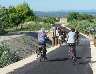
- Eine Radtour um den Luberon ist wunderbar.
- Bei Windstille, und die gibt es tatsächlich mal, ist eine Übernachtung oben auf dem Mont Ventoux auf dem SP unterhalb des Gipfels ein weiteres, unvergessliches Highlight.
- Die Verdonschlucht ist von BEIDEN Seiten sehr zu empfehlen.
- Die SP nördlich des Lac de Castillon sind prima: St. André les Alpes und Colmar ! les Alpes.
- Die Côte d'Azur mit dem Womo kann man sich eigentlich schenken, mit der Ausnahme: Halbinsel von Giens und die vorgelagerten Inseln Poquerolles(Auto frei), Port Cros,.. Wanderparadiese,
- Die Route des Crêtes zwischen La Ciotat und Cassis ist großartig!
- Insgesamt würde ich die Runterfahrt nicht über die schöne Route Napoleon planen, sondern die Route des Grandes Alpes unbedingt bevorzugen. Ist sicherlich eine fahrerisch größere Herausforderung, aber um Welten schöner. Durch 4 Nationalparks, ....
- Sollten Sie sich doch zu einer Reise durch die Hautes Alpes entschließen, so käme eine Anreise durch den schweizer und den französischen Jura ebenfalls in Frage. Das wäre eine wunderschöne, wildromantische Alternative abseits der Touristenströme. Lediglich ein Besuch von Annecy ist erst ab Ende Oktober ratsam. Viel Spaß und auf eine erlebnisreiche Reise.
Miesimo on Tour
Ganz herzlichen Dank,
für den super ausführlichen und informativen Kommentar. Mit so etwas Positivem hatte ich wirklich nicht gerechnet. Die Planung auf dieser Seite sollte eigentlich nur die Corona-Zeit zu Hause mit etwas sinnvollem füllen. Das hier macht die Planungen auf dieser Seite jetzt noch spannender.
Die Route ist ja auch noch nicht fertig, sie soll über ein paar Pyrenäen-Pässe durch Toulouse, Carcassonne, Albi und der Ardeche zurück nach Hause führen.
Über weitere Kommentare ( mal sehen wenn’s weiter geht) würde ich mich riesig freuen.
LG Hermann (hier Christa)
PS: unsere bisherigen Reisen kannst Du auf unserem Block mole-on-tour.de nachverfolgen