Silberbrink
Nordrhein-Westfalen, Deutschland
51° 55' 19.6" N 7° 43' 33.7" E
51.9221212 7.7260255
• Head east. Go for 39 m.
• Continue on Eschstraße. Go for 77 m.
• Turn left onto Eschstraße. Go for 121 m.
• Turn right onto Münsterstraße. Go for 489 m.
• Continue on Am Steintor. Go for 2.2 km.
• Take the 2nd exit from roundabout onto L585. Go for 3.6 km.
• Turn right onto Münsterstraße (L586). Go for 266 m.
• Turn left onto L850. Go for 5.4 km.
• Turn left onto Altendorf (B54). Go for 54 m.
• Turn right onto Altendorf (K40). Go for 770 m.
• Continue on K40. Go for 305 m.
• Continue on Altendorf (K40). Go for 63 m.
• Continue on K40. Go for 4.5 km.
• Turn left onto Amelsbürener Straße (K39). Go for 780 m.
• Turn left onto Davensberger Straße (L844) toward Ascheberg. Go for 2.4 km.
• Turn left onto Steinfurter Straße (B58) toward Bremen/A1/Dortmund/Ahlen/Drensteinfurt. Go for 1.1 km.
• Take ramp onto A1 toward Dortmund. Go for 149 km.
• Take exit 109 toward Trier/B51/Euskirchen onto A1. Go for 37.7 km.
• Take exit 114 toward Trier/Dahlem/Blankenheim onto B51. Go for 31.5 km.
• Turn right toward Olzheim/Schwarzer Mann/Wolfsschlucht. Go for 63 m.
• Take the 4th exit from roundabout onto Industriegebiet (L23). Go for 360 m.
• Turn left onto K164. Go for 1.8 km.
• Continue on Brückenstraße (K164). Go for 1.3 km.
• Continue on Talstraße (K164). Go for 1.7 km.
• Continue on K164. Go for 959 m.
• Continue on Dausfeld (K164). Go for 566 m.
• Continue on K164. Go for 464 m.
• Turn right onto Campingplatz. Go for 98 m.
• Arrive at Campingplatz. Your destination is on the left.
☍
247,2 km
(2 hrs. 36 min.)
Day
Prüm
Beautiful campsite located on the Prüm. About 2 km from Prüm town centre.
K 164, Prüm, Eifelkreis Bitburg-Prüm, Rheinland-Pfalz, Deutschland
50° 13' 10.7" N 6° 26' 18.9" E
50.2196250 6.4385884
• Head southwest on Campingplatz. Go for 98 m.
• Turn right onto Am Kurpark (K164). Go for 169 m.
• Turn left onto Prümtalstraße. Go for 1.4 km.
• Take the 3rd exit from roundabout onto Heldstraße (B265) toward A60/Köln/Trier/Bitburg/Gerolstein. Go for 1.0 km.
• Turn right onto K182 toward Pronsfeld/Niederprüm. Go for 676 m.
• Turn left onto Sankt-Vither-Straße (B410) toward Clerf (Lux.)/Pronsfeld. Go for 1.7 km.
• Turn left onto L11 toward A60/Lüttich/St. Vith/Trier/Bitburg/Gewerbegebiet Niederprüm. Go for 1.9 km.
• Take the 2nd exit from roundabout onto A60 toward Lüttich/Liège/St. Vith/Bleialf. Go for 12.6 km.
• Take ramp toward Bleialf/Habscheid. Go for 358 m.
• Turn right onto L1 toward Bleialf/Großlangenfeld. Go for 1.2 km.
• Turn right onto L16. Go for 202 m.
• Turn sharp left onto Weißenhof (L1). Go for 2.1 km.
• Turn right onto Hauptstraße (L1) toward Lützkampen/Leidenborn/Großkampenberg/Heckhuscheid. Go for 5.5 km.
• Turn right onto L1 toward Burg Reuland(Belg)/Lützkampen. Go for 2.3 km.
• Turn right onto Grenzstraße (L15) toward Burg-Reuland/Welchenhausen/Stupbach. Go for 3.4 km.
• Turn left onto K155. Go for 1.3 km.
• Continue on In der Loch (K155). Go for 203 m.
• Continue on K155. Go for 1.7 km.
• Continue on Dorfstraße (K155). Go for 362 m.
• Turn left onto K155. Go for 225 m.
• Continue on Oberhausen. Go for 149 m.
• Turn left onto Oberhausen toward Ouren. Go for 444 m.
• Turn left onto Ourtalstrasse. Go for 2.6 km.
• Turn left onto Ouren. Go for 212 m.
• Continue on Am Schlossberg. Go for 351 m.
• Turn right onto Zum Dreiländereck. Go for 1.1 km.
• Arrive at Zum Dreiländereck.
☍
43,0 km
( 38 min.)
Day
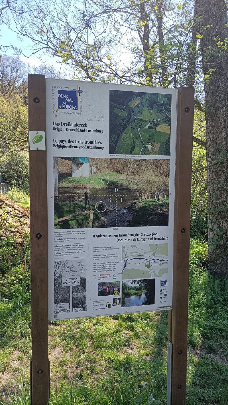
Tag 2: Ouren
Idyllic route to the border triangle. Lots of information about the "birth" of the EU.
Zum Dreiländereck, Ouren, Verviers, Lüttich, Belgien
50° 7' 49.1" N 6° 8' 11.1" E
50.1303115 6.1364151
• Head south on Zum Dreiländereck. Go for 26 m.
• Continue on CR338. Go for 2.0 km.
• Continue on Hauptstrooss (CR338). Go for 1.2 km.
• Continue on CR338. Go for 1.3 km.
• Turn left onto N7 toward Heinerscheid/Diekirch/Clervaux. Go for 1.8 km.
• Turn right onto CR338 toward Binsfeld/Troisvierges/Zone Industrielle Lentzweiler/Zone Industrielle Eselborn/Rossmillen. Go for 3.4 km.
• Turn left onto CR335. Go for 2.3 km.
• Continue on Maulusmuehle (CR335). Go for 407 m.
• Continue on CR335. Go for 3.1 km.
• Take the 2nd exit from roundabout onto Route de Bastogne (CR335). Go for 775 m.
• Arrive at Rue de la Gare (CR335).
☍
16,3 km
( 14 min.)
Clerf
Beautiful place. Unfortunately we couldn't find a parking space. So we drove on.
Route d'Urspelt, Clerf, Kanton Clerf, Luxemburg
50° 3' 42.1" N 6° 1' 27" E
50.0616982 6.0241690
• Head southeast on Rue de la Gare (CR335). Go for 1.5 km.
• Turn right onto Place de la Libération. Go for 35 m.
• Continue on Klatzewee. Go for 539 m.
• Arrive at Klatzewee. Your destination is on the right.
☍
2,1 km
( 3 min.)
Camping Clervaux
Unfortunately the campsite was completely full. We moved on.
Klatzewee 33, 9714, Clervaux, Luxembourg
50° 3' 18" N 6° 1' 25" E
50.0550000 6.0236100
• Head toward Place Aloyse Meyer on Klatzewee. Go for 539 m.
• Continue on Place de la Libération. Go for 35 m.
• Turn right onto CR335. Go for 4.2 km.
• Take ramp onto N7. Go for 6.5 km.
• Take the 3rd exit from roundabout onto Haaptstrooss (N7) toward Hoscheid/Diekirch. Go for 1.6 km.
• Take the 2nd exit from roundabout onto Route de Diekirch (N7) toward Luxembourg/Ettelbruck/Diekirch. Go for 13.7 km.
• Take the 1st exit from Rond-Point Friedhaff roundabout onto B7 toward Luxembourg/Ettelbruck/Erpeldange/N27. Go for 3.5 km.
• Take ramp toward Ettelbruck-Centre/Ingeldorf/Diekirch. Go for 836 m.
• Take the 1st exit from roundabout onto N7 toward Erpeldange/Ettelbruck-Centre. Go for 689 m.
• Take the 2nd exit from roundabout onto N7. Go for 295 m.
• Continue on Avenue J-F Kennedy (N7). Go for 418 m.
• Arrive at Avenue J-F Kennedy (N7).
☍
32,3 km
( 26 min.)
Ettelbrück
Avenue John F. Kennedy 58, Ettelbrück, Kanton Diekirch, Luxemburg
49° 50' 56.4" N 6° 6' 23.2" E
49.8490094 6.1064312
• Head toward Rue de l'École Agricole on Avenue J-F Kennedy (N7). Go for 261 m.
• Keep left onto Rue Prince Henri (N7a) toward Schieren/Luxembourg/Wiltz/Bastogne/Gare. Go for 126 m.
• Continue on Rue du Canal (N7a) toward Wiltz/Bastogne/Schieren/Luxembourg. Go for 16 m.
• Continue on Rue du Canal (N7) toward Wiltz/Bastogne/Schieren/Luxembourg. Go for 471 m.
• Continue on Place Marie-Thérèse (N7). Go for 195 m.
• Continue on N7. Go for 37 m.
• Take the 2nd exit from roundabout onto Rue du Deich. Go for 163 m.
• Turn slightly right onto Hall Deich. Go for 115 m.
• Arrive at Hall Deich. Your destination is on the left.
☍
1,4 km
( 2 min.)
Ettelbrück - Parkplatz
Central parking. Ettelbruck city center within walking distance. Nice, small old town.
Kanton Diekirch, Luxemburg
49° 50' 39.7" N 6° 5' 43" E
49.8443723 6.0952824
• Head northwest on Hall Deich. Go for 70 m.
• Turn right onto Hall Deich. Go for 72 m.
• Turn right onto CR345B. Go for 105 m.
• Continue on N15. Go for 176 m.
• Take the 5th exit from roundabout onto N15 toward Feulen/Wiltz/Bastogne. Go for 705 m.
• Turn left onto Chemin du Camping. Go for 220 m.
• Keep right onto Chemin du Camping. Go for 611 m.
• Turn slightly left. Go for 79 m.
• Turn right. Go for 63 m.
• Arrive at your destination on the right.
☍
2,1 km
( 4 min.)
Camping Ettelbruck
Terraced campsite with restaurant. Clean sanitary facilities.
Chemin du Camping, Ettelbrück, Kanton Diekirch, Luxemburg
49° 50' 46.4" N 6° 4' 51.3" E
49.8462101 6.0809287
• Head southeast. Go for 63 m.
• Turn left toward Chemin du Camping. Go for 79 m.
• Turn slightly right onto Chemin du Camping. Go for 115 m.
• Keep right onto Chemin du Camping. Go for 716 m.
• Turn right onto Rue de Bastogne (N15). Go for 300 m.
• Turn right onto Rue Michel Weber (CR305) toward Michelbouch/Grentzingen. Go for 167 m.
• Turn left onto CR345B. Go for 156 m.
• Continue on N15. Go for 176 m.
• Take the 2nd exit from roundabout onto N7 toward Luxembourg/Diekirch/Clervaux/St. Vith. Go for 980 m.
• Take ramp onto B7. Go for 1.6 km.
• Keep left onto A7 toward Luxembourg/Mersch/Colmar-Berg Industrie-Komplex. Go for 24.9 km.
• Take the exit toward Bruxelles/Metz/Luxembourg-Gare/E29 onto A1. Go for 9.8 km.
• Take the exit toward Luxembourg-Gare/Hesperange onto A3. Go for 644 m.
• Take exit 1 toward Hesperange/Luxembourg-Gasperich/Gasperich/Luxembourg onto CR231. Go for 785 m.
• Keep left onto CR231 toward Luxembourg/Gasperich. Go for 329 m.
• Turn left onto Boulevard de Kockelscheuer. Go for 692 m.
• Continue on Boulevard de Kockelscheuer. Go for 671 m.
• Turn left onto Route de Bettembourg (CR186). Go for 451 m.
• Turn right onto Route de Bettembourg. Go for 258 m.
• Turn right onto Route de Bettembourg. Go for 146 m.
• Turn right. Go for 92 m.
• Turn left. Go for 121 m.
• Arrive at your destination on the left.
☍
43,3 km
( 34 min.)
Day
City-Camping Kockelscheuer
Campsite located south of Luxembourg. Clean sanitary facilities. The campsite is ideal for exploring the city of Luxembourg. Bus stop near the campsite. Public transport in Luxembourg is free to use.
route de Bettembourg 22, 1899, Luxemburg, Luxembourg
49° 34' 22" N 6° 6' 32" E
49.5727800 6.1088900
• Head east. Go for 33 m.
• Continue on Route de Bettembourg. Go for 146 m.
• Turn left onto Route de Bettembourg. Go for 258 m.
• Turn left onto Route de Bettembourg (CR186). Go for 1.4 km.
• Arrive at Route d'Esch (CR186). Your destination is on the right.
☍
1,9 km
( 3 min.)
Day
Besichtigung Luxembourg
We took the free public transport (bus) into the city centre and looked at the many beautiful old buildings there, including the impressive city wall.
Day
Luxemburg
Route d'Esch, Luxemburg, Kanton Luxemburg, Luxemburg
49° 35' 5.5" N 6° 6' 56.3" E
49.5848537 6.1156382
• Head north on Route d'Esch (CR186). Go for 229 m.
• Turn left onto Route d'Esch (CR186/CR231). Go for 711 m.
• Turn left onto Rue Léopold Hoffmann. Go for 17 m.
• Arrive at Rue Léopold Hoffmann. Your destination is on the left.
☍
1,0 km
( 1 min.)
Q8-Tankstelle, Luxemburg
Route d'Esch 260, Luxemburg, Kanton Luxemburg, Luxemburg
49° 35' 33.8" N 6° 7' 0.2" E
49.5927121 6.1167199
• Head toward Rue Henri Pensis on Rue Léopold Hoffmann. Go for 17 m.
• Turn right onto Route d'Esch (CR186). Go for 708 m.
• Continue on Rue Friedrich Wilhelm Raiffeisen (CR231). Go for 841 m.
• Take ramp toward Bruxelles/Liège/Esch/Alzette/A4. Go for 503 m.
• Arrive at Croix de Gasperich.
☍
2,1 km
( 2 min.)
Luxemburg
Rue Isaac Newton, Luxemburg, Kanton Luxemburg, Luxemburg
49° 34' 42.7" N 6° 7' 24.5" E
49.5785226 6.1234626
• Take ramp onto A6. Go for 6.6 km.
• Take exit 4 toward Luxembourg-Centre/Strassen/Aéroport/Plateau de Kirchberg/Trier/Metz/Esch/Alzette onto N6 (Route d'Arlon). Go for 1.4 km.
• Arrive at Route d'Arlon (N6). Your destination is on the right.
☍
8,0 km
( 5 min.)
Supermarkt, Strassen
Areler Straße 9-11, Strassen, Kanton Luxemburg, Luxemburg
49° 37' 0.3" N 6° 5' 36.6" E
49.6167511 6.0934948
• Head west on Route d'Arlon (N6). Go for 694 m.
• Take ramp onto A6 toward Aéroport/Plateau de Kirchberg/Arlon/Bruxelles/Liège. Go for 10.4 km.
• Take exit 1 toward Steinfort/Dippach/Garnich. Go for 307 m.
• Turn left onto N13 toward Steinfort. Go for 1.1 km.
• Take the 3rd exit from roundabout onto Wandhaff (N6). Go for 3.5 km.
• Arrive at Rue de Luxembourg (N6).
☍
16,0 km
( 11 min.)
Steinfort
Luxemburger Straße 7, Steinfort, Kanton Kapellen, Luxemburg
49° 39' 35.1" N 5° 54' 57.1" E
49.6597405 5.9158637
• Head toward Rue de Hobscheid on Rue de Luxembourg (N6). Go for 895 m.
• Continue on Rosenberg (N4). Go for 4.1 km.
• Arrive at Route de Luxembourg (N4).
☍
5,0 km
( 4 min.)
Arel
Luxemburger Straße, Arel, Arel, Luxemburg, Belgien
49° 39' 40.9" N 5° 50' 57.6" E
49.6613623 5.8493225
• Head toward Chemin de Trèves on Route de Luxembourg (N4). Go for 1.6 km.
• Turn left onto Birel. Go for 494 m.
• Turn left onto Route de Longwy (N81). Go for 1.7 km.
• Take the 3rd exit from roundabout onto Route de Longwy (N81) toward Luxembourg/Longwy/Aubange/Messancy. Go for 362 m.
• Enter the roundabout. Go for 125 m.
• Arrive at your destination.
☍
4,2 km
( 4 min.)
Arel
N81, Arel, Arel, Luxemburg, Belgien
49° 38' 57.9" N 5° 49' 8.1" E
49.6494040 5.8189113
• Follow the roundabout. Go for 69 m.
• Take the 2nd exit from roundabout onto Rue de l'École (N81) toward Bruxelles/Namur/Liège/Arlon. Go for 274 m.
• Take the 4th exit from roundabout onto E25/E411 toward Bruxelles/Namur/Liège. Go for 35.7 km.
• Continue on E411 toward Bruxelles/Namur. Go for 43.7 km.
• Take exit 23 toward Rochefort. Go for 300 m.
• Continue on Rue du Sourd d'Ave (N94). Go for 732 m.
• Turn right onto Rue Tchèsau (N86) toward Rochefort/Han-sur-Lesse. Go for 5.2 km.
• Arrive at Rue de Charleville (N86). Your destination is on the left.
☍
85,9 km
( 49 min.)
Camping Le Pirot
Small campsite directly on the river Lesse.
Rue de Charleville, Han-sur-Lesse, Dinant, Namur, Belgium
50° 7' 37.8" N 5° 11' 5.6" E
50.1271591 5.1848832
• Head toward Rue du Plan d'Eau on Rue de Charleville (N86). Go for 247 m.
• Turn sharp right onto Rue d'Hamptay. Go for 22 m.
• Arrive at Rue d'Hamptay. Your destination is on the right.
☍
0,3 km
( )
Day
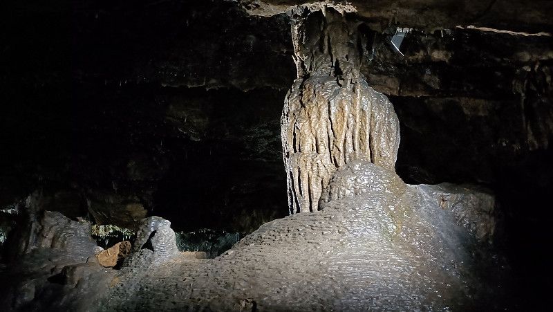
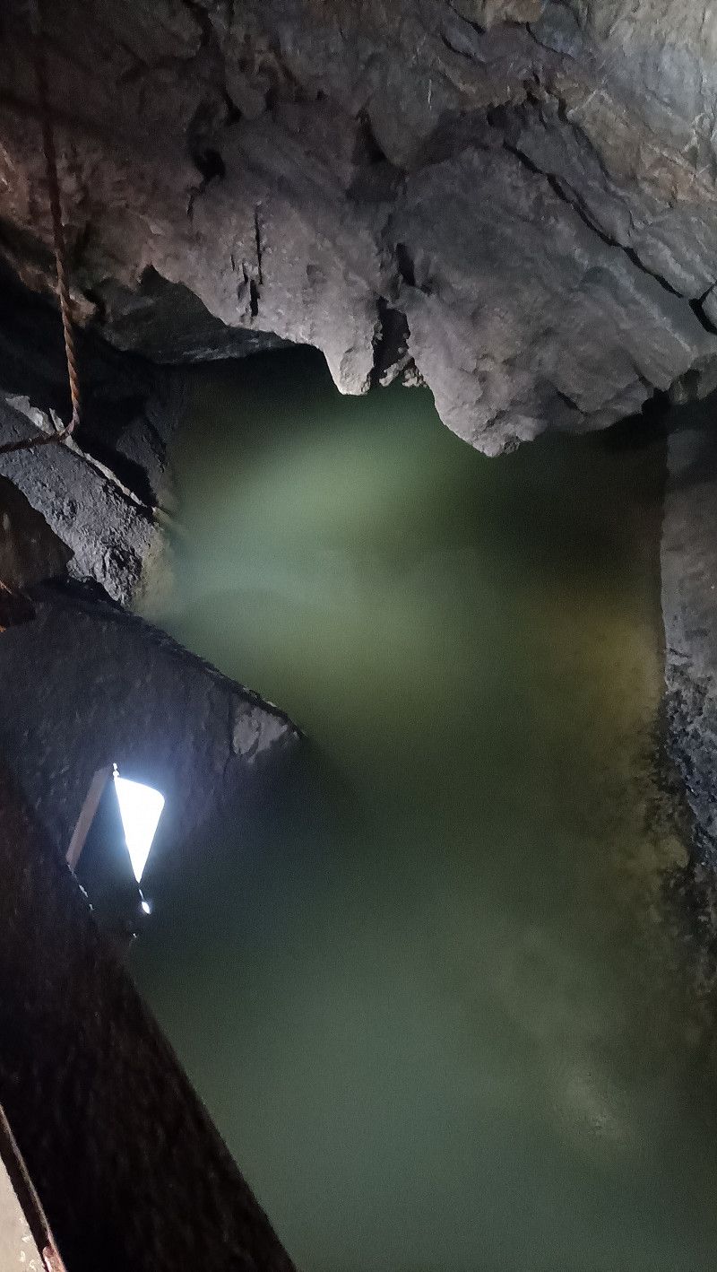
Domaine des Grottes de Han
The stalactite cave is worth seeing. The tour lasted about 1 hour 15 minutes. Afterwards we saw the archaeological finds in the small museum.
There is also a wildlife safari here, but we didn't do it.
A museum tram runs from the village to the entrance of the grotto.
Rue Joseph Lamotte 2, Han-sur-Lesse, Dinant, Namur, Belgien
50° 7' 31" N 5° 11' 14.3" E
50.1252740 5.1873135
• Head southwest on Rue d'Hamptay. Go for 63 m.
• Turn right onto Rue des Sarrasins. Go for 194 m.
• Turn left onto Rue Joseph Lamotte (N86). Go for 5.3 km.
• Turn left onto Rue du Sourd d'Ave (N94) toward Wellin/E411. Go for 815 m.
• Turn right and take ramp onto E411 toward Bruxelles/Namur. Go for 51.2 km.
• Take the exit toward Mons/Charleroi onto E42. Go for 51.7 km.
• Take the exit toward Bruxelles/Soignies/N57b/Braine-le-Comte onto A501. Go for 4.5 km.
• Take the 2nd exit from roundabout onto N57 toward N57b/Braine-le-Comte/Soignies/Ecaussinnes. Go for 1.3 km.
• Pass 2 roundabouts and continue on N57. Go for 3.6 km.
• Take the 3rd exit from roundabout onto N57. Go for 1.9 km.
• Take the 3rd exit from roundabout onto N57. Go for 3.1 km.
• Take the 3rd exit from roundabout onto N57. Go for 2.4 km.
• Take the 1st exit from roundabout onto Chaussée d'Enghien (N55) toward E429/Enghien. Go for 10.0 km.
• Take the 4th exit from roundabout onto E429 (La Hennuyère) toward Doornik/Tournai/Ath/Aat. Go for 11.9 km.
• Take exit 29 toward Lessines/Grammont/Ath/N7. Go for 311 m.
• Take the 1st exit from roundabout onto Chaussée Victor Lampe (N57) toward Grammont/Lessines. Go for 738 m.
• Pass 3 roundabouts and continue on Boulevard René Branquart (N57). Go for 5.5 km.
• Take the 1st exit from roundabout onto Porte d'Ogy. Go for 293 m.
• Turn left onto Grand'Place. Go for 65 m.
• Turn right onto Rue du Ruichon. Go for 145 m.
• Turn left onto Rue de l'Hôpital. Go for 11 m.
• Arrive at Rue de l'Hôpital. Your destination is on the left.
☍
154,9 km
(1 hrs. 42 min.)
Day
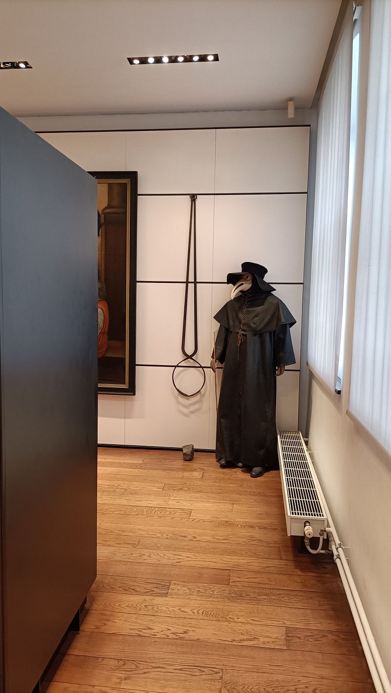
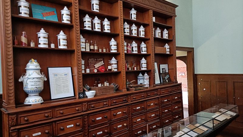
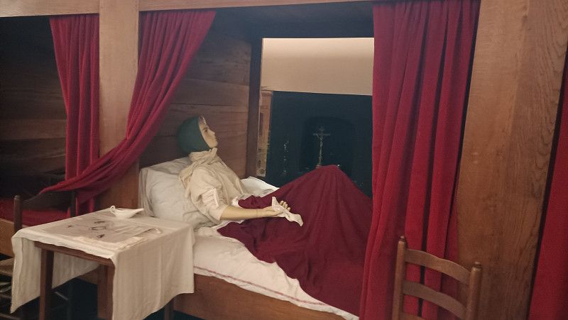
Hospital Notre Dame a la Rose, Lessines
About 300 years of hospital history well presented. Guided tour in German via small dictaphone
Rue des Moulins 36, Lessines, Ath, Hennegau, Belgien
50° 42' 47.1" N 3° 49' 52" E
50.7130969 3.8310999
• Head toward Rue des Moulins on Rue de l'Hôpital. Go for 32 m.
• Turn left onto Rue des Moulins. Go for 151 m.
• Turn right onto Rue de Grammont. Go for 326 m.
• Turn right onto Rue de Grammont (N522). Go for 6.7 km.
• Take the 2nd exit from roundabout onto Astridlaan (N42) toward Gent/Aalst/N460/Industriezone Geraardsbergen. Go for 1.3 km.
• Turn right onto Zonnebloemstraat (N495) toward Edingen/Industriezone Unalpark. Go for 744 m.
• Take the 3rd exit from roundabout onto Voldersstraat toward Schendelbeke/Onkerzele. Go for 2.3 km.
• Continue on Botermelkstraat. Go for 643 m.
• Turn left onto Onkerzelestraat. Go for 742 m.
• Turn left onto Onkerzelestraat. Go for 255 m.
• Arrive at Onkerzelestraat. Your destination is on the right.
☍
13,2 km
( 20 min.)
Provinciaal Domein "De Gavers"
Campsite by a lake. Unfortunately, our pitch had been leveled by slag, which meant we carried the slag into the RV. Use of the nearby indoor swimming pool is possible with a 50% discount on the entrance fee. It is worth using the campsite as a starting point for a bike tour along the Dender river to Geraadsbergen. We did not go the other way.
Onkerzelestraat 280, Onkerzele, Belgien
50° 47' 29.3" N 3° 55' 15.9" E
50.7914644 3.9210751
• Head east on Onkerzelestraat. Go for 255 m.
• Turn right onto Onkerzelestraat. Go for 1.2 km.
• Turn right onto Kampstraat. Go for 495 m.
• Turn left onto Voldersstraat. Go for 13 m.
• Turn right onto Kampstraat. Go for 944 m.
• Continue on Kerkborre. Go for 488 m.
• Continue on Moenebroekstraat. Go for 728 m.
• Take the 2nd exit from roundabout onto Moenebroekstraat. Go for 1.8 km.
• Continue on Bildeken. Go for 467 m.
• Turn left onto Leopoldlaan (N8). Go for 577 m.
• Turn right onto Gapenberg. Go for 1.5 km.
• Continue on Gentweg. Go for 469 m.
• Turn left onto Assestraat. Go for 355 m.
• Turn right onto N42. Go for 571 m.
• Continue on Gentweg (N42b). Go for 2.5 km.
• Continue on Europaweg (N42). Go for 690 m.
• Take the 3rd exit from roundabout onto Europaweg (N42) toward Wetteren/E40/Industriezone Zottegem 1-2. Go for 2.9 km.
• Turn left onto Buke (N462) toward Leeuwergem. Go for 1.4 km.
• Take the 2nd exit from roundabout onto Buke (N462). Go for 43 m.
• Turn right onto Buke. Go for 82 m.
• Turn right onto Leeuwerikstraat. Go for 63 m.
• Arrive at Leeuwerikstraat. Your destination is on the right.
☍
17,5 km
( 24 min.)
Day
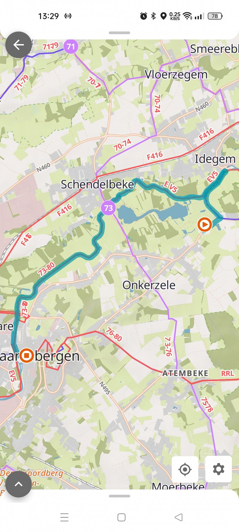
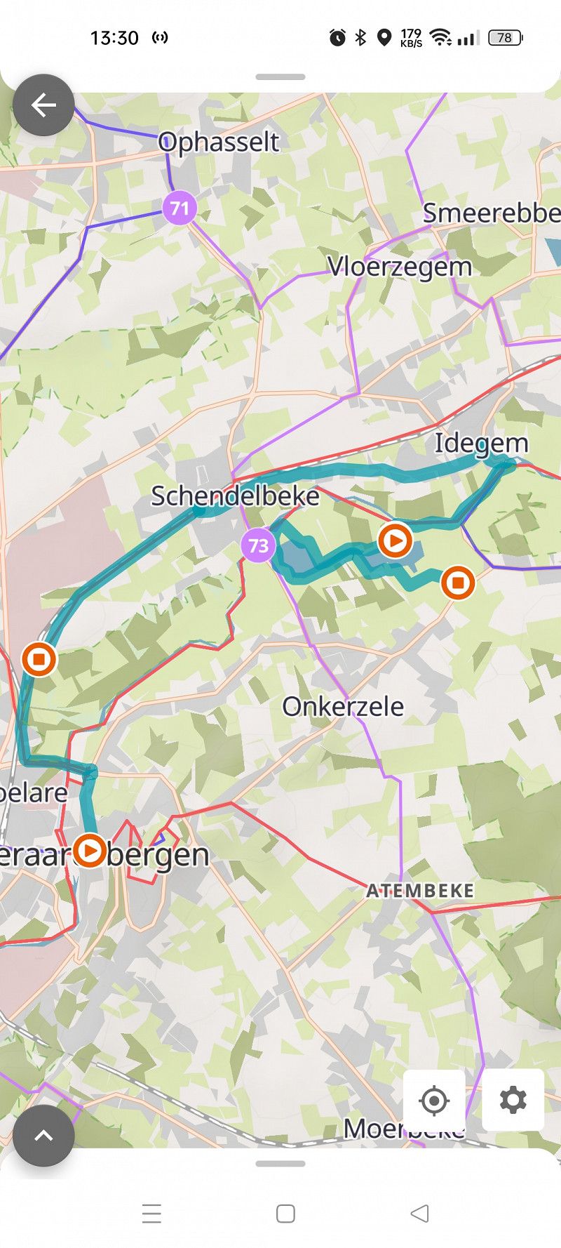
Radtour nach Geraadsbergen
Start at the campsite in an easterly direction towards Idegem, from there follow the river Dender in a westerly direction to Geraadsbergen. Gerradsbergen is a nice little place. On the way back we followed the cycle path along the railway via Schendelbeke and Idegem to the campsite. Cycled about 19 km.
Day
Supermarkt in Zottegem
Buke 50, Leeuwergem, Aalst, Ostflandern, Belgien
50° 52' 41.3" N 3° 49' 2.4" E
50.8781487 3.8173379
• Head southeast on Leeuwerikstraat. Go for 63 m.
• Turn right onto Buke. Go for 109 m.
• Take the 4th exit from roundabout onto Buke (N462). Go for 275 m.
• Take the 1st exit from roundabout onto Buke (N462). Go for 1.4 km.
• Turn left onto Europaweg (N42). Go for 10.7 km.
• Take the 3rd exit from roundabout onto E40 toward Gent. Go for 96.9 km.
• Take exit 1 toward N34/Adinkerke/Plopsaland. Go for 486 m.
• Turn right onto Kromfortstraat (N34) toward Adinkerke/De Panne. Go for 296 m.
• Take the 2nd exit from roundabout onto Stationsstraat (N34). Go for 439 m.
• Turn left onto Dorpsstraat. Go for 322 m.
• Continue on Smekaertstraat. Go for 848 m.
• Turn right onto Langgeleedstraat. Go for 332 m.
• Arrive at Langgeleedstraat. Your destination is on the left.
☍
112,2 km
(1 hrs. 14 min.)
Campingplatz Kindervreugde in De Panne
Nice little campsite. Shaded areas available. Disposal facility for RVs available. About 4 km to the sea. Starting point for a bike tour. The tram's end point in De Panne can be reached on foot in about 15 minutes. You can take the tram along the entire Belgian coast.
Langgeleedstraat, De Panne, Veurne, Westflandern, Belgien
51° 4' 34.4" N 2° 35' 8.8" E
51.0762270 2.5857702
• Head north on Langgeleedstraat. Go for 67 m.
• Turn right onto Zwartenhoekstraat. Go for 854 m.
• Continue on Stationsplein. Go for 97 m.
• Take the 1st exit from Stationsplein roundabout onto Stationsplein. Go for 238 m.
• Turn right onto De Pannelaan (N34). Go for 638 m.
• Take the 2nd exit from roundabout onto Kromfortstraat (N34). Go for 523 m.
• Turn left and take ramp onto E40 toward Brussel/Brugge/Oostende. Go for 37.2 km.
• Take exit 6 toward Oostende/A10/De Haan onto N377 (Stationsstraat). Go for 2.8 km.
• Keep left onto Stationsstraat (N377) toward De Haan/Stalhille. Go for 151 m.
• Take the 3rd exit from roundabout onto Expressweg (N377) toward De Haan/Stalhille. Go for 5.2 km.
• Take the 2nd exit from roundabout onto Vijfwegestraat toward Vlissegem. Go for 2.4 km.
• Turn right onto Warvinge. Go for 1.9 km.
• Turn left onto Grotestraat. Go for 554 m.
• Turn right onto Duinenweg. Go for 499 m.
• Take the 2nd exit from roundabout. Go for 34 m.
• Continue on Duinenweg. Go for 15 m.
• Continue on Waterkasteellaan. Go for 545 m.
• Turn left onto Koninklijke Baan (N34). Go for 244 m.
• Arrive at Koninklijke Baan (N34).
☍
54,0 km
( 41 min.)
Day
Radtour nach de Panne
Took a short bike ride to the beach at De Panne. Walked along the beach promenade.
Day
Mit der Tram nach Oostende
Today we took the tram to Middelkerke. We explored the beach promenade. It is similar to the one in De Panne. Mostly multi-storey. Beautiful wide beach. We continued on the tram to Ostend and back to the campsite in De Panne.
Day
De Haan - Klemskerke
Koninklijke Baan 68, Klemskerke, Ostende, Westflandern, Belgien
51° 16' 46.1" N 3° 2' 6.9" E
51.2794736 3.0352548
• Head toward Christianaplein on Koninklijke Baan (N34). Go for 804 m.
• Turn left onto Vader Catslaan. Go for 58 m.
• Turn slightly left onto Van Maerlantlaan. Go for 175 m.
• Arrive at Van Maerlantlaan.
☍
1,0 km
( 2 min.)
De Haan
Van Maerlantlaan 18, De Haan, Ostende, Westflandern, Belgien
51° 16' 26.9" N 3° 1' 41.7" E
51.2741439 3.0282406
• Head toward Jean d'Ardennelaan on Van Maerlantlaan. Go for 26 m.
• Turn left onto Jean d'Ardennelaan. Go for 185 m.
• Turn right onto Leopoldlaan. Go for 231 m.
• Continue on Koninklijk Plein. Go for 35 m.
• Continue on Tramlijn-Oost. Go for 68 m.
• Turn left onto Nieuwe Rijksweg (N34y) toward Blankenberge/Wenduine. Go for 197 m.
• Arrive at N34y.
☍
0,7 km
( 2 min.)
De Haan
Nieuwe Rijksweg, De Haan, Ostende, Westflandern, Belgien
51° 16' 24.2" N 3° 2' 9.3" E
51.2733971 3.0359272
• Head toward Duinenweg on N34y. Go for 53 m.
• Continue on Nieuwe Rijksweg (N34e). Go for 76 m.
• Continue on N34y. Go for 39 m.
• Continue on Nieuwe Rijksweg (N34e). Go for 108 m.
• Continue on N34y. Go for 336 m.
• Continue on Nieuwe Rijksweg (N34e). Go for 715 m.
• Continue on N34y. Go for 419 m.
• Continue on N34y. Go for 437 m.
• Continue on Nieuwe Rijksweg (N34e). Go for 189 m.
• Arrive at Nieuwe Rijksweg (N34e). Your destination is on the right.
☍
2,4 km
( 2 min.)
Vlissegem
Nieuwe Rijksweg, Vlissegem, Ostende, Westflandern, Belgien
51° 17' 18.3" N 3° 3' 26.3" E
51.2884074 3.0572991
• Head toward Drift on Nieuwe Rijksweg (N34e). Go for 1.4 km.
• Continue on Drift (N34y). Go for 222 m.
• Keep right onto Ringlaan (N34) toward Brugge. Go for 1.2 km.
• Take the 2nd exit from roundabout onto Blankenbergsesteenweg (N34) toward Blankenberge. Go for 2.7 km.
• Take the 3rd exit from roundabout onto Waterkasteelstraat (N34) toward Centrum-Haven. Go for 319 m.
• Continue on De Smet de Naeyerlaan (N34). Go for 881 m.
• Turn slightly left onto Koning Leopold III Plein (N34). Go for 370 m.
• Take the 2nd exit from roundabout onto Koning Albert I-Laan (N34) toward Knokke-Heist/Zeebrugge. Go for 8.0 km.
• Arrive at Elizabetlaan (N34).
☍
15,2 km
( 20 min.)
Knokke-Heist
Elizabetlaan, Knokke-Heist, Brügge, Westflandern, Belgien
51° 20' 21.6" N 3° 13' 52" E
51.3393341 3.2311099
• Head east on Elizabetlaan (N34). Go for 106 m.
• Take the 1st exit from roundabout onto Heistlaan (N300) toward A11/Antwerpen/N376/Brugge/Sluis. Go for 707 m.
• Turn left onto Heistlaan (N300). Go for 545 m.
• Pass 2 roundabouts and continue on Heistlaan (N300). Go for 3.7 km.
• Keep left onto Heistlaan (N300) toward Dudzele/Westkapelle. Go for 265 m.
• Take the 2nd exit from roundabout onto Knoksebaan (N376) toward Antwerpen/E34/Knokke/N49/Sluis. Go for 3.8 km.
• Take the 2nd exit from roundabout onto Dudzelestraat (N376) toward Sluis. Go for 387 m.
• Take the 2nd exit from roundabout onto Dudzelestraat (N376) toward Sluis. Go for 889 m.
• Take the 2nd exit from roundabout onto Hazegrasstraat. Go for 2.9 km.
• Take the 1st exit from roundabout onto Retranchementstraat. Go for 2.0 km.
• Continue on Knokkeweg. Go for 322 m.
• Arrive at Knokkeweg.
☍
15,6 km
( 17 min.)
Retranchement
Zwinstraat, Retranchement, Seeland, Niederlande
51° 20' 48.6" N 3° 22' 54.4" E
51.3468300 3.3817861
• Head northeast on Knokkeweg.
• Turn right onto Kanaalweg. Go for 1.4 km.
• Arrive at Kanaalweg.
☍
1,4 km
( 1 min.)
Retranchement
Kanaalweg, Retranchement, Seeland, Niederlande
51° 20' 4.5" N 3° 23' 7.7" E
51.3345842 3.3854585
• Head toward Nieuwedijk on Kanaalweg. Go for 1.7 km.
• Turn sharp left onto Hoogstraat (N675). Go for 4.3 km.
• Take the 1st exit from roundabout onto Mariastraat (N674). Go for 1.8 km.
• Continue on Dorpsplein (N674). Go for 2.2 km.
• Take the 3rd exit from roundabout onto Commerswerveweg (N253) toward Breskens/Schoondijke/Terneuzen/Goes (TOL)/Middelburg (TOL)/Industrieterrein Stampershoek. Go for 1.9 km.
• Take the 2nd exit from roundabout onto Lange Heerenstraat (N253) toward Breskens/Schoondijke/Terneuzen/Goes (TOL)/Middelburg (Tol). Go for 3.3 km.
• Take the 1st exit from roundabout onto Middenweg (N61) toward IJzendijke/Terneuzen/Goes/Middelburg. Go for 6.2 km.
• Take the 2nd exit from roundabout onto Middenweg (N61) toward Biervliet/Terneuzen/Goes/Middelburg. Go for 5.3 km.
• Keep right toward Hoek/Terneuzen/Goes/Middelburg. Go for 43 m.
• Take the 2nd exit from roundabout onto Middenweg (N61) toward Hoek/Terneuzen/Goes/Middelburg. Go for 2.6 km.
• Keep right toward Hoek/Terneuzen/Goes/Middelburg. Go for 42 m.
• Take the 2nd exit from roundabout onto Middenweg (N61) toward Hoek/Terneuzen/Goes/Middelburg. Go for 4.7 km.
• Keep right toward Havens 0-5600/Terneuzen/Hulst/Goes/Middelburg. Go for 41 m.
• Take the 2nd exit from roundabout onto Hoofdweg (N61) toward Havens 0-5600/Terneuzen/Hulst. Go for 1.9 km.
• Keep left onto Hoofdweg (N61) toward Havens 0-1200/Havens 4000-5600/Sluiskil/Goes (TOL)/Middelburg (TOL)/N62. Go for 371 m.
• Take the 2nd exit from roundabout onto N61 toward Havens 0-1200/Havens 4000-5600/Sluiskil/Goes (TOL)/Middelburg (TOL). Go for 244 m.
• Take the 2nd exit from roundabout onto Westerscheldetunnelweg (N62) toward Havens 0-500/Goes (TOL)/Middelburg (TOL). Go for 19.0 km.
• Take ramp onto Bernhardweg West (N254). Go for 9.8 km.
• Keep left onto Sloeweg Noord (N254) toward Domburg/Goes/Bergen op Zoom. Go for 44 m.
• Take the 3rd exit from roundabout onto A58 toward Domburg/Goes/Bergen op Zoom. Go for 1.1 km.
• Take exit 38 toward Industrieterrein Arnestein/Middelburg-Oost/Veere/Domburg/Burgh-Haamstede onto N57. Go for 5.7 km.
• Keep right toward Havenpoortweg/N57. Go for 130 m.
• Continue on Havenpoortweg (N57). Go for 2.8 km.
• Pass 7 roundabouts and continue on Kraaijensteinweg (N57). Go for 23.0 km.
• Take the 2nd exit from roundabout onto Serooskerkseweg (N652) toward Burgh-Haamstede/Renesse. Go for 450 m.
• Take the 2nd exit from roundabout onto Serooskerkseweg toward Burgh-Haamstede/Nieuw-Haamstede. Go for 421 m.
• Continue on Kloosterweg. Go for 197 m.
• Turn left onto Nieuweweg. Go for 532 m.
• Turn slightly right onto Vertonsweg. Go for 762 m.
• Turn sharp left onto Kloosterweg. Go for 897 m.
• Turn right onto Maireweg. Go for 980 m.
• Turn left onto J.J. Boeijesweg. Go for 63 m.
• Arrive at J.J. Boeijesweg.
☍
102,4 km
(1 hrs. 27 min.)
Camping De Duinhoeve
Campsite with separate areas for dog owners and non-dog owners. Sanitary buildings OK and clean. It is about 1.4 km to the beach and a good 1 km to the town of Burgh Hamstede. The campsite is a good starting point for cycling tours in the surrounding area.
J J Boeijesweg 62, 4328 HC, Burgh Haamstede, Netherlands
51° 43' 21" N 3° 43' 47" E
51.7225000 3.7297200
• Head toward Maireweg on J.J. Boeijesweg. Go for 63 m.
• Turn right onto Maireweg. Go for 980 m.
• Turn left onto Kloosterweg. Go for 581 m.
• Turn left onto Westerenbanweg. Go for 410 m.
• Continue on J.J. Boeijesweg. Go for 609 m.
• Continue on Deltaweg. Go for 76 m.
• Turn right onto J.J. Boeijesweg. Go for 128 m.
• Turn left onto Kloosterweg. Go for 732 m.
• Continue on Serooskerkseweg. Go for 186 m.
• Turn right onto Scheepswerfstraat. Go for 54 m.
• Turn slightly right onto Kriekemeet. Go for 217 m.
• Turn slightly right onto 't Schoolplein. Go for 42 m.
• Turn left onto 't Schoolplein. Go for 153 m.
• Turn right onto Dapperweg. Go for 36 m.
• Continue on Ring. Go for 55 m.
• Turn left onto Zuidstraat. Go for 86 m.
• Turn right onto Sluispad. Go for 99 m.
• Turn slightly right onto Julianastraat. Go for 208 m.
• Turn right onto Bernhardstraat. Go for 131 m.
• Turn left onto Burghseweg. Go for 236 m.
• Arrive at Burghseweg.
☍
5,1 km
( 13 min.)
Day
Radtour Campingplatz nach Westerschouven
Bike tour to Westerschouven and back. Approximately 19 km
Day
Day
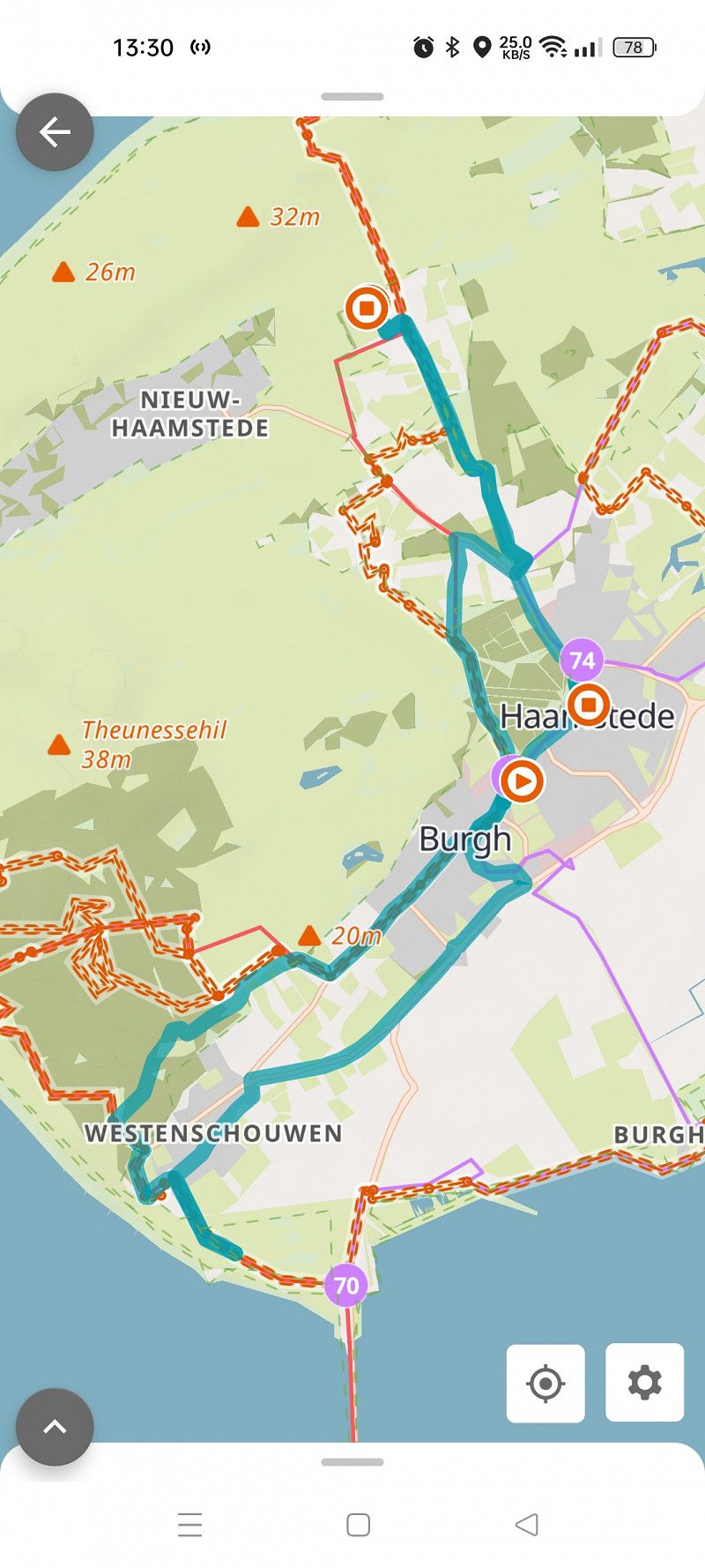
Burgh-Haamstede
Bicycle shop "Fietsenverhuur Zeeland Burgh Hamstede". Small bicycle repairs.
Burghseweg 58a, Burgh-Haamstede, Seeland, Niederlande
51° 41' 40" N 3° 44' 14.5" E
51.6944496 3.7373719
• Head northeast on Burghseweg. Go for 236 m.
• Turn right onto Bernhardstraat. Go for 492 m.
• Continue on Zandweg. Go for 301 m.
• Take the 3rd exit from roundabout onto Kraaijensteinweg (N57) toward Burgh-Haamstede/Renesse/Zierikzee/Rotterdam. Go for 780 m.
• Take the 2nd exit from roundabout onto Serooskerkseweg (N652) toward Burgh-Haamstede/Renesse. Go for 450 m.
• Take the 2nd exit from roundabout onto Serooskerkseweg toward Burgh-Haamstede/Nieuw-Haamstede. Go for 421 m.
• Continue on Kloosterweg. Go for 691 m.
• Turn right onto Vroonweg. Go for 444 m.
• Turn right onto Breedsteweg. Go for 126 m.
• Arrive at Breedsteweg.
☍
3,9 km
( 7 min.)
Burgh-Haamstede
Breedsteweg 3, Burgh-Haamstede, Seeland, Niederlande
51° 42' 29.4" N 3° 44' 36.2" E
51.7081682 3.7433802
• Head toward Biesterveldwegje on Breedsteweg. Go for 151 m.
• Continue on Hogezoom. Go for 319 m.
• Turn right onto Armhoeksweg. Go for 325 m.
• Turn left onto Lagezoom. Go for 1.7 km.
• Arrive at Lagezoom.
☍
2,5 km
( 5 min.)
Renesse
Lagezoom 25a, Renesse, Seeland, Niederlande
51° 43' 9.8" N 3° 46' 10.4" E
51.7193925 3.7695533
• Head northeast on Lagezoom. Go for 999 m.
• Turn right onto Roelandsweg. Go for 32 m.
• Take the 2nd exit from roundabout onto Recreatieverdeelweg (N652). Go for 510 m.
• Take the 2nd exit from roundabout onto N652. Go for 1.3 km.
• Take the 2nd exit from roundabout onto N652 toward Scharendijke/Rotterdam. Go for 1.4 km.
• Take the 3rd exit from roundabout onto N652 toward Ouddorp (N57)/Rotterdam (N57)/Scharendijke/Brouwershaven/Grevelingenmeer. Go for 449 m.
• Take the 1st exit from roundabout onto N57 toward Ouddorp/Rotterdam. Go for 8.6 km.
• Keep right toward Ouddorp/Hellevoetsluis/Rotterdam. Go for 51 m.
• Take the 2nd exit from roundabout onto Oudelandse Zeedijk (N57) toward Ouddorp/Hellevoetsluis/Rotterdam. Go for 5.1 km.
• Keep right toward Goedereede/Hellevoetsluis/Rotterdam. Go for 36 m.
• Take the 2nd exit from roundabout onto Provincialeweg (N57) toward Goedereede/Hellevoetsluis/Rotterdam. Go for 5.0 km.
• Keep left onto N57 toward Brielle/Rotterdam/Havens Stellendam/Industrieterrein Stellendam. Go for 73 m.
• Take the 2nd exit from Ted Jansen Plein roundabout onto N57 toward Brielle/Rotterdam/Havens Stellendam/Industrieterrein Stellendam. Go for 7.3 km.
• Keep right toward Rockanje/Brielle/Rotterdam. Go for 26 m.
• Take the 2nd exit from roundabout onto Dammenweg (N57) toward Rockanje/Brielle/Rotterdam. Go for 2.4 km.
• Keep right toward Brielle/Rotterdam. Go for 27 m.
• Take the 2nd exit from roundabout onto Dammenweg (N57) toward Brielle/Rotterdam. Go for 2.7 km.
• Keep right toward Brielle/Rotterdam. Go for 35 m.
• Take the 2nd exit from roundabout onto Dammenweg (N57) toward Brielle/Rotterdam. Go for 6.3 km.
• Keep right onto N15 toward Rozenburg/Havens 5225-5600. Go for 321 m.
• Take the 2nd exit from roundabout onto N15 toward Rozenburg/Havens 100-5500. Go for 1.9 km.
• Continue on A15 (Europaweg). Go for 809 m.
• Take the exit onto A24. Go for 4.4 km.
• Take the left exit onto A20. Go for 4.9 km.
• Take the exit toward Amsterdam/Delft/Den Haag onto A4 (Knooppunt Kethelplein). Go for 53.4 km.
• Keep right onto A5 (Knooppunt de Hoek) toward Zaanstad/Haarlem. Go for 6.9 km.
• Take the exit toward Alkmaar/Haarlem onto A9. Go for 31.6 km.
• Take exit 12 toward Ring-West/Den Helder/Heiloo/Alkmaar-Centrum/N9. Go for 1.2 km.
• Take the 4th exit from Verkeersplein Kooimeer roundabout onto Heilooër Tolweg (N9) toward Egmond/Bergen/Heiloo/Den Helder. Go for 940 m.
• Continue on Heilooër Tolweg (N9) toward Ring Alkmaar/Egmond/Bergen/Den Helder. Go for 3.4 km.
• Continue on Martin Luther Kingweg (N9) toward RING Noord/Schoorl/Den Helder. Go for 2.6 km.
• Continue on Helderseweg (N9) toward Schoorl/Den Helder. Go for 12.0 km.
• Take the 1st exit from roundabout onto Rijksweg (N9) toward Den Helder/Schagen. Go for 10.3 km.
• Turn left onto Parallelweg toward 't Zand/Groote Keeten. Go for 75 m.
• Turn right onto Parallelweg toward 't Zand/Groote Keeten. Go for 423 m.
• Continue on Groteweg toward Groote Keeten/Callantsoog. Go for 1.0 km.
• Turn right onto Noordschinkeldijk. Go for 1.3 km.
• Continue on Helmweg. Go for 1.8 km.
• Turn right onto Duinweg (N502) toward Julianadorp/Den Helder. Go for 2.2 km.
• Continue on Zanddijk (N502). Go for 2.6 km.
• Turn right onto Noorder Sandt. Go for 576 m.
• Turn right onto Noorder Sandt. Go for 116 m.
• Turn right. Go for 104 m.
• Turn right. Go for 134 m.
• Arrive at your destination on the right.
☍
187,4 km
(2 hrs. 22 min.)
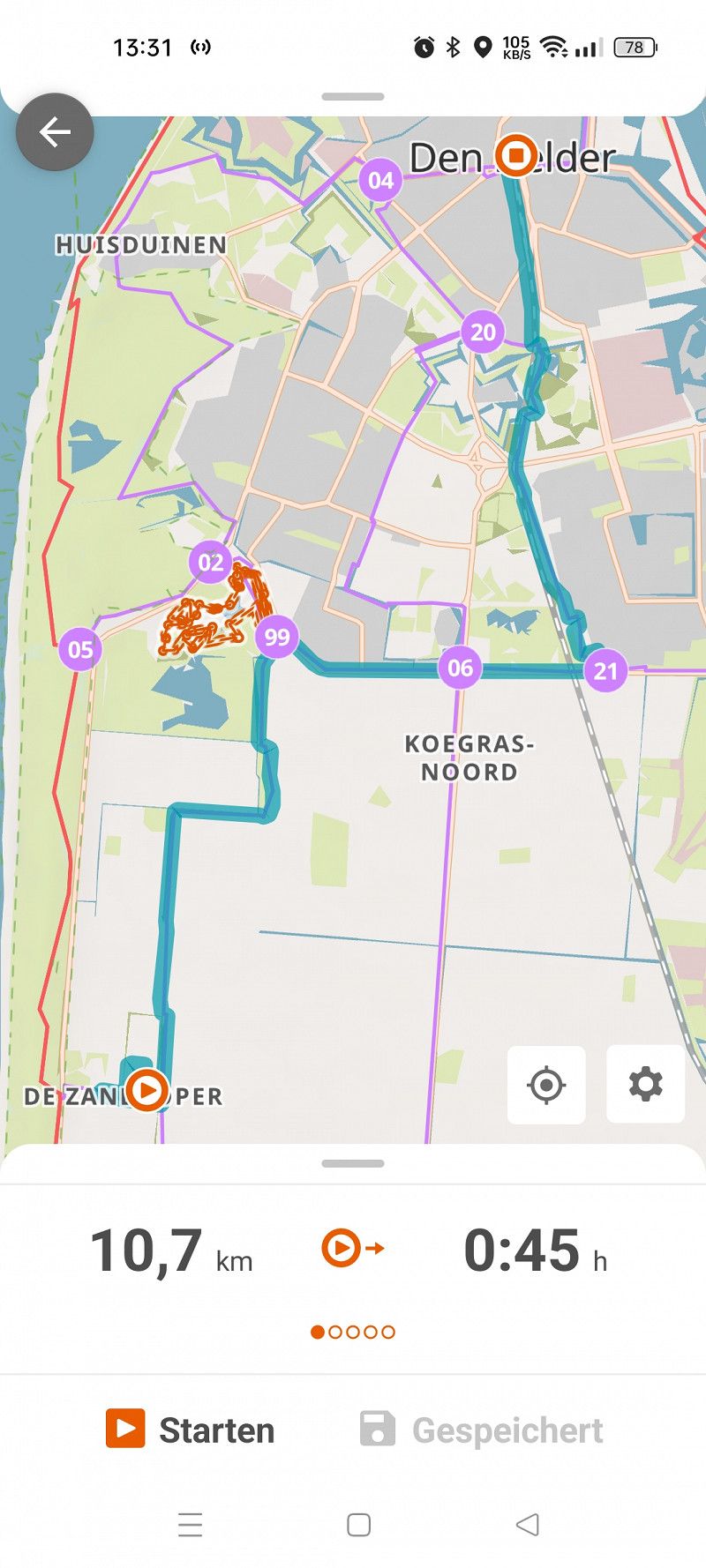
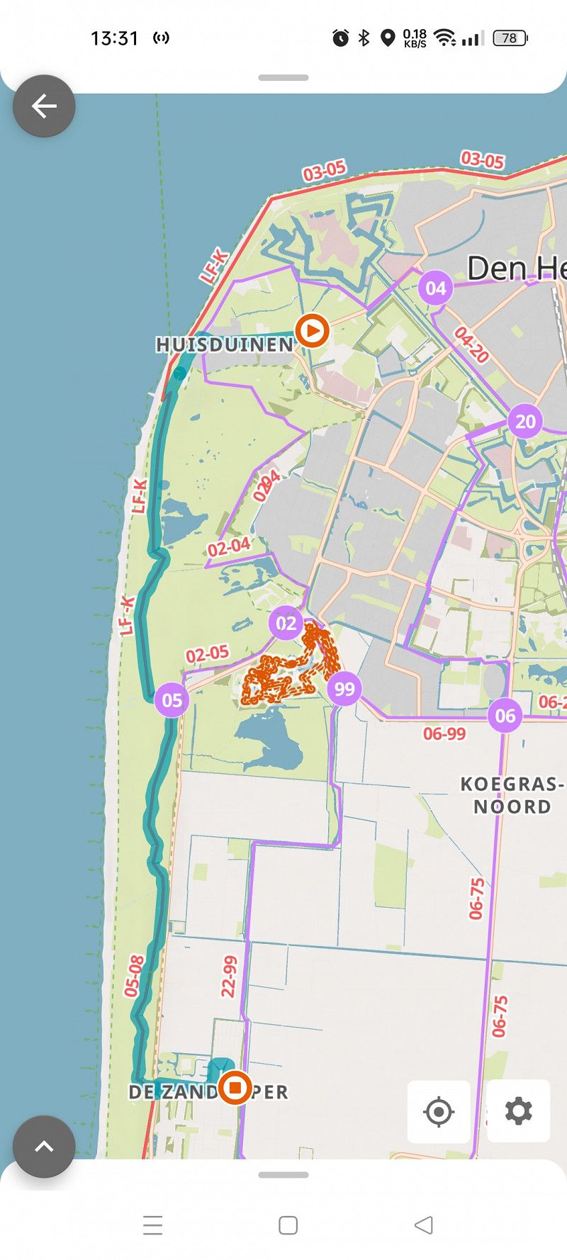
Julianadorp Camping 't Noorder Sandt
Beautiful campsite with indoor pool (free to use), restaurant and cafeteria. About 1 km from the beach. Clean sanitary facilities. Den Helder can be reached by bike in about 30 minutes. We particularly liked the paved bike path through the dune landscape.
Noorder Sandt, Julianadorp, Nordholland, Niederlande
52° 54' 21.3" N 4° 43' 38.4" E
52.9059139 4.7273360
• Head west. Go for 134 m.
• Turn left toward Noorder Sandt. Go for 104 m.
• Turn left onto Noorder Sandt. Go for 116 m.
• Turn left onto Noorder Sandt. Go for 576 m.
• Turn left onto Zanddijk (N502). Go for 585 m.
• Turn left onto Van Foreestweg toward Julianadorp/Alkmaar. Go for 1.7 km.
• Take the 2nd exit from roundabout onto Van Foreestweg. Go for 458 m.
• Arrive at Van Foreestweg.
☍
3,6 km
( 7 min.)
Day
Day
Day
Julianadorp
Van Foreestweg 105, Julianadorp, Nordholland, Niederlande
52° 53' 53.3" N 4° 44' 57.1" E
52.8981441 4.7492046
• Head toward Langevliet on Van Foreestweg. Go for 179 m.
• Turn right onto Langevliet. Go for 19 m.
• Turn left onto Schoolweg. Go for 159 m.
• Arrive at Schoolweg.
☍
0,4 km
( 1 min.)
Julianadorp
Schoolweg 10, Julianadorp, Nordholland, Niederlande
52° 53' 50.9" N 4° 45' 14.8" E
52.8974733 4.7541101
• Head east on Schoolweg. Go for 44 m.
• Turn left onto Schoolweg. Go for 24 m.
• Turn right onto Schoolweg. Go for 16 m.
• Continue straight ahead. Go for 133 m.
• Arrive at your destination.
☍
0,2 km
( 1 min.)
Julianadorp, Supermarkt
Schoolweg, Julianadorp, Nordholland, Niederlande
52° 53' 53.5" N 4° 45' 21.8" E
52.8982025 4.7560418
• Head north. Go for 102 m.
• Turn left onto Schoolweg. Go for 115 m.
• Turn right onto Schoolweg. Go for 16 m.
• Turn left onto Schoolweg. Go for 24 m.
• Turn left onto Schoolweg. Go for 801 m.
• Take the 3rd exit from roundabout onto Schoolweg. Go for 1.1 km.
• Turn left onto Rijksweg (N9). Go for 2.4 km.
• Turn left onto N99 toward Luchthaven Den Helder/Kon. Marine Nieuwe Haven/Industrieterrein Oostoever/Industrieterrein Kooypunt/Breezand/Leeuwarden. Go for 383 m.
• Turn left onto N99 toward Breezand/Leeuwarden/Amsterdam/Kon. Marine Nieuwe Haven/Industrieterrein Oostoever. Go for 628 m.
• Keep right toward Anna Paulowna/Amsterdam/Leeuwarden. Go for 27 m.
• Pass 4 roundabouts and continue on Rijksstraatweg (N99). Go for 16.6 km.
• Take the 1st exit from roundabout onto Akkerweg. Go for 108 m.
• Turn right onto Rijksstraatweg. Go for 19 m.
• Arrive at Rijksstraatweg. Your destination is on the right.
☍
22,3 km
( 23 min.)
Den Oever - Tankstelle
Akkerweg 39a, Den Oever, Nordholland, Niederlande
52° 55' 26.9" N 5° 1' 4.1" E
52.9241506 5.0177986
• Head toward Oosterweg on Rijksstraatweg. Go for 19 m.
• Turn left onto Akkerweg. Go for 78 m.
• Take the 1st exit from roundabout onto Rijksstraatweg (N99) toward Den Oever/Leeuwarden/Amsterdam. Go for 750 m.
• Take the 2nd exit from roundabout onto Rijksstraatweg (N99) toward Leeuwarden/Amsterdam. Go for 692 m.
• Turn left and take ramp onto A7 (Afsluitdijk) toward Leeuwarden/Groningen. Go for 48.1 km.
• Keep left onto N7. Go for 4.2 km.
• Take ramp toward Sneek-Oost/Oppenhuizen/Uitwellingerga/Leeuwarden/N354. Go for 309 m.
• Take the 3rd exit from roundabout. Go for 308 m.
• Take the 2nd exit from roundabout onto Stadsrondweg-Oost (N354) toward Ring Sneek/Sneekermeer/Leeuwarden. Go for 169 m.
• Take the 2nd exit from roundabout onto Stadsrondweg-Oost (N354). Go for 1.0 km.
• Take the 1st exit from roundabout onto Groenedijk. Go for 219 m.
• Continue on Fiifgeawei. Go for 1.8 km.
• Turn right onto Paviljoenwei. Go for 879 m.
• Continue on De Potten. Go for 570 m.
• Turn right. Go for 71 m.
• Turn left. Go for 24 m.
• Turn left. Go for 41 m.
• Arrive at your destination on the left.
☍
59,3 km
( 44 min.)
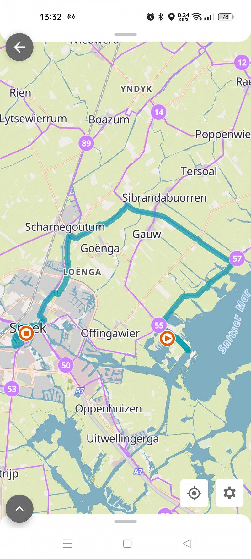
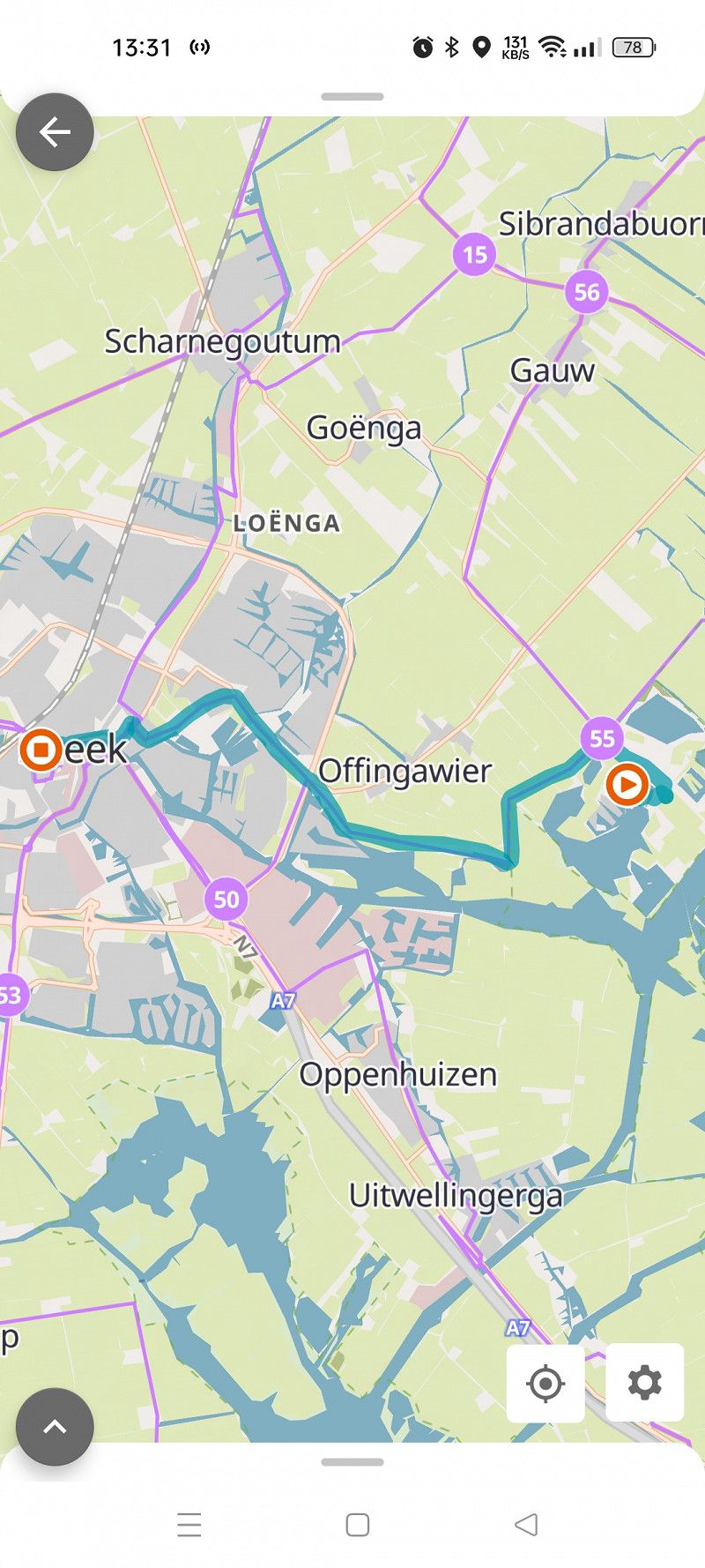
RCN Vakantiepark de Potten
Campsite directly on the Sneeker Meer with a kiosk and restaurant. Sanitary buildings are clean, but showing their age.
The center of Sneek is about 6 km away and can be easily reached by bike. Nice old town with numerous small shops and places to eat.
De Potten 2-38, 8626 GG, Offingawier, Niederlande
53° 1' 51.2" N 5° 43' 32.8" E
53.0308834 5.7257911
• Head southwest. Go for 41 m.
• Turn right. Go for 52 m.
• Turn right toward De Potten. Go for 45 m.
• Turn left onto De Potten. Go for 570 m.
• Continue on Paviljoenwei. Go for 879 m.
• Turn left onto Fiifgeawei. Go for 1.8 km.
• Continue on Groenedijk. Go for 195 m.
• Pass 2 roundabouts and continue on Groenedijk. Go for 1.1 km.
• Turn right onto Middelzeelaan. Go for 144 m.
• Arrive at Middelzeelaan. Your destination is on the right.
☍
4,8 km
( 9 min.)
Day
Day
Day
Sneek - Supermarkt
Middelzeelaan 4, Sneek, Friesland, Niederlande
53° 2' 21" N 5° 40' 39.6" E
53.0391574 5.6776666
• Head toward Bordine on Middelzeelaan. Go for 144 m.
• Turn left onto Groenedijk. Go for 654 m.
• Take the 2nd exit from roundabout onto Groenedijk. Go for 365 m.
• Take the 1st exit from roundabout onto Stadsrondweg-Oost (N354). Go for 1.0 km.
• Take the 1st exit from roundabout onto Stadsrondweg-Oost (N354). Go for 116 m.
• Keep left onto Stadsrondweg-Oost (N354). Go for 42 m.
• Take the 3rd exit from roundabout toward Joure/(A7)/Groningen/(A7). Go for 309 m.
• Take the 2nd exit from roundabout onto A7 toward Joure/Groningen. Go for 11.3 km.
• Take the left exit toward Groningen/Leeuwarden/Zwolle/Heerenveen/Joure onto A7. Go for 8.9 km.
• Take the exit toward Heerenveen/Zwolle onto A32. Go for 23.0 km.
• Take exit 7 toward Steenwijk-Noord/Giethoorn/Emmeloord. Go for 480 m.
• Turn right onto Steenwijkerweg (N334). Go for 566 m.
• Take the 2nd exit from roundabout onto Ruxveenseweg (N334). Go for 1.9 km.
• Pass 2 roundabouts and continue on Ruxveenseweg (N334). Go for 1.5 km.
• Take the 1st exit from roundabout onto Blokzijlseweg (N333/N334). Go for 773 m.
• Turn left onto Beulakerweg (N334). Go for 11.9 km.
• Turn right onto Belterweg. Go for 1.8 km.
• Arrive at Belterweg.
☍
64,8 km
( 52 min.)
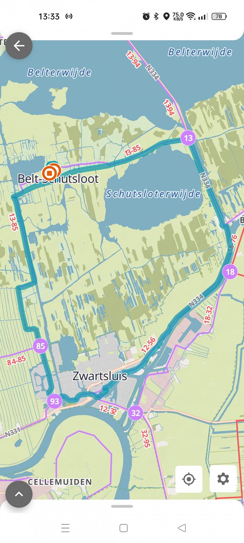
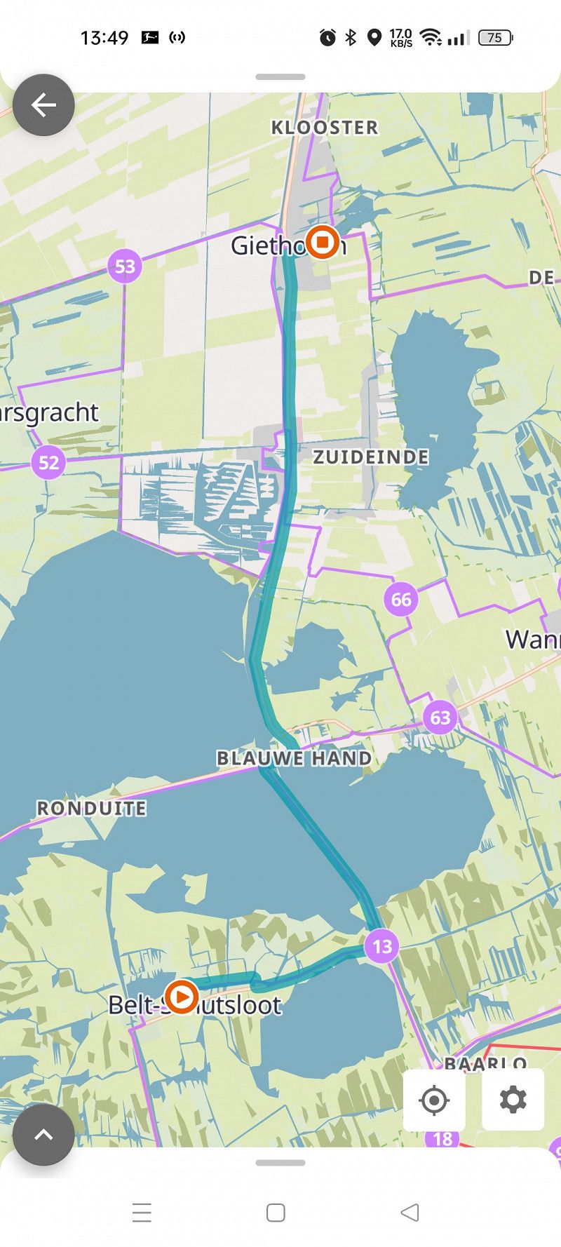
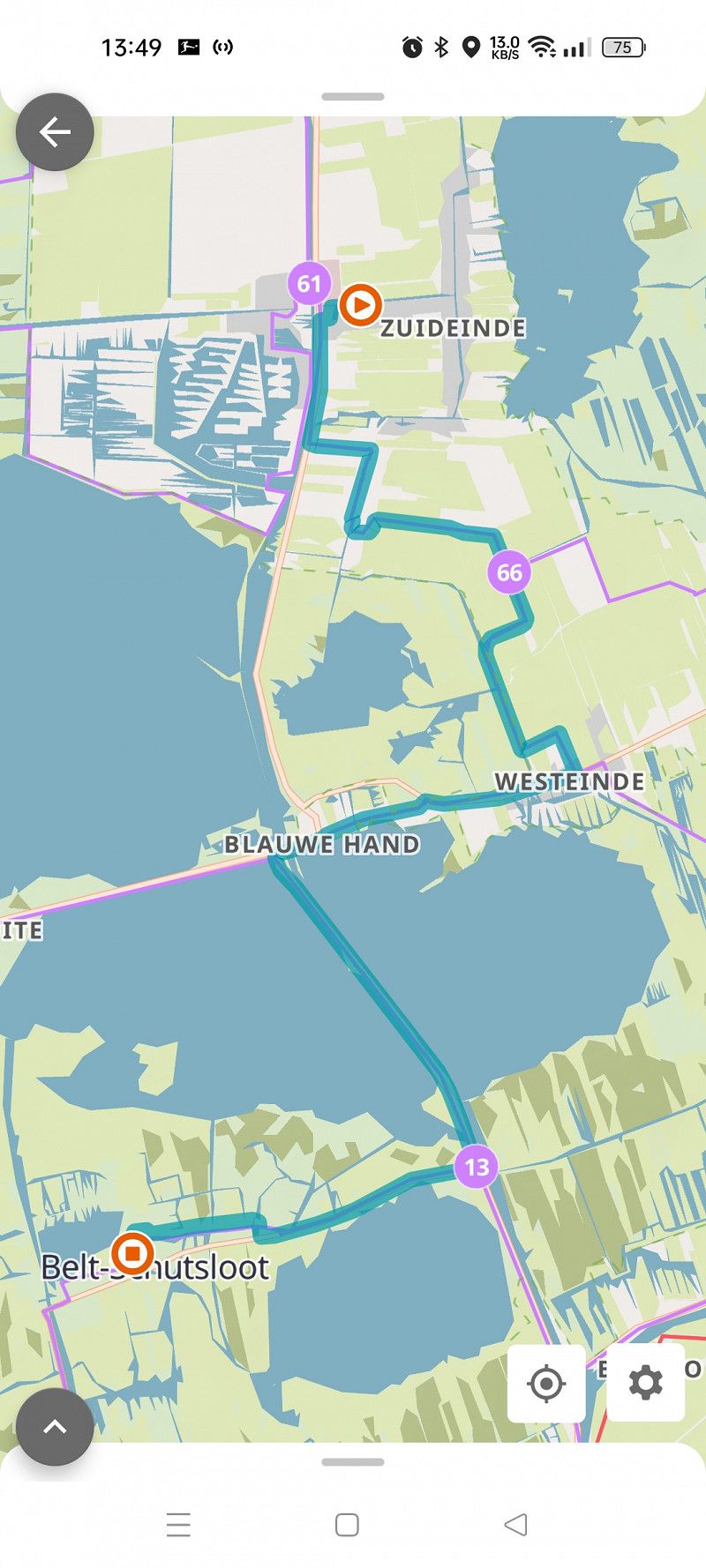
Belt-Schutsloot
Belterweg 32, Belt-Schutsloot, Oberyssel, Niederlande
52° 40' 13.4" N 6° 4' 0.4" E
52.6703781 6.0667822
• Head toward Meidoornlaan on Belterweg. Go for 307 m.
• Turn right onto Kerklaan. Go for 202 m.
• Continue on Vaste Belterweg. Go for 119 m.
• Turn left onto Vaste Belterweg. Go for 119 m.
• Turn left. Go for 32 m.
• Arrive at your destination on the left.
☍
0,8 km
( 2 min.)
Camping Kleine Belterwijde
Vaste Belterweg, Belt-Schutsloot, Oberyssel, Niederlande
52° 40' 12.2" N 6° 3' 39" E
52.6700659 6.0608362
• Head toward Vaste Belterweg. Go for 32 m.
• Turn right onto Vaste Belterweg. Go for 119 m.
• Turn right onto Vaste Belterweg. Go for 119 m.
• Turn left onto Noorderweg. Go for 795 m.
• Turn left onto Belterweg. Go for 1.4 km.
• Turn right onto Blauwehandseweg (N334). Go for 1.4 km.
• Keep left toward Blauwehandseweg/N334. Go for 21 m.
• Take the 2nd exit from roundabout onto Zomerdijk (N375). Go for 5.2 km.
• Take the 2nd exit from roundabout onto Bremenbergweg (N375). Go for 1.4 km.
• Take the 1st exit from roundabout onto Handelsweg. Go for 1.2 km.
• Turn right onto Industrieweg. Go for 633 m.
• Continue on Europalaan. Go for 510 m.
• Pass 2 roundabouts and continue on Europalaan. Go for 1.5 km.
• Arrive at Europalaan. Your destination is on the right.
☍
14,3 km
( 17 min.)
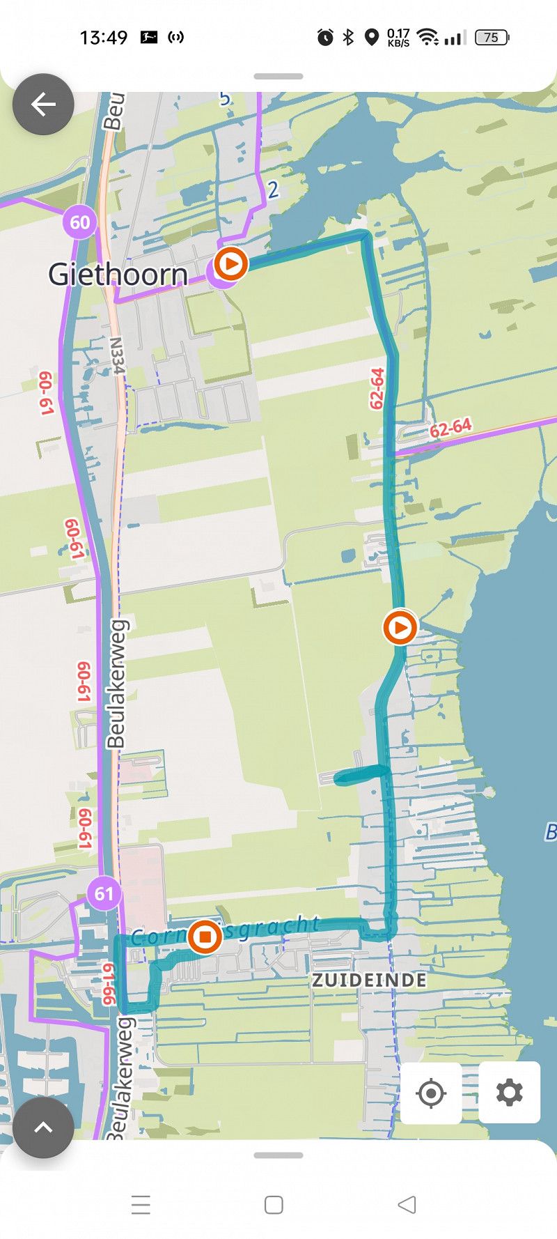
Day
Radtour nach Giethoorn und zurück
Day
Staphorst
Europalaan, Staphorst, Oberyssel, Niederlande
52° 40' 29.5" N 6° 11' 18.3" E
52.6748744 6.1884104
• Head toward Rijksparallelweg on Europalaan. Go for 465 m.
• Turn left onto Werkhorst. Go for 883 m.
• Take the 1st exit from roundabout onto Reestlaan. Go for 203 m.
• Continue on Leonard Springerlaan. Go for 810 m.
• Continue on Parallelweg. Go for 279 m.
• Turn left onto Oosteinde. Go for 122 m.
• Turn right onto Oosteinde. Go for 117 m.
• Turn right onto Prinsengracht. Go for 160 m.
• Turn left onto Kromme elleboog. Go for 143 m.
• Continue on Kromme elleboog. Go for 122 m.
• Arrive at Brouwersstraat.
☍
3,3 km
( 6 min.)
Meppel
Brouwersstraat, Meppel, Drente, Niederlande
52° 41' 45.8" N 6° 11' 24.1" E
52.6960632 6.1900356
• Head toward Weteringdwarsstraat on Brouwersstraat. Go for 116 m.
• Turn slightly right onto Bleekerseiland. Go for 12 m.
• Turn right onto Kleine Oever. Go for 108 m.
• Turn right onto Hoogetin. Go for 63 m.
• Continue on Kleine Akkerstraat. Go for 26 m.
• Arrive at Kleine Akkerstraat.
☍
0,3 km
( )
Meppel
Hoogetin 1, Meppel, Drente, Niederlande
52° 41' 51.2" N 6° 11' 22.7" E
52.6975630 6.1896311
• Head toward Kleine Kerkstraat on Kleine Akkerstraat. Go for 23 m.
• Turn left onto Grote Akkerstraat. Go for 131 m.
• Arrive at Grote Akkerstraat.
☍
0,2 km
( )
Meppel
Grote Akkerstraat 26, Meppel, Drente, Niederlande
52° 41' 55.4" N 6° 11' 21.1" E
52.6987236 6.1891912
• Head northwest on Grote Akkerstraat. Go for 14 m.
• Continue on De Putstoel. Go for 55 m.
• Turn left onto Grote Oever. Go for 175 m.
• Arrive at Grote Oever.
☍
0,2 km
( )
Meppel
Grote Oever 160, Meppel, Drente, Niederlande
52° 41' 51.4" N 6° 11' 17.5" E
52.6976135 6.1882078
• Head toward Hoogetin on Grote Oever. Go for 37 m.
• Continue on Kleine Oever. Go for 108 m.
• Turn left onto Bleekerseiland. Go for 12 m.
• Turn slightly left onto Brouwersstraat. Go for 238 m.
• Continue on Kromme elleboog. Go for 70 m.
• Turn slightly left onto Kromme elleboog. Go for 73 m.
• Turn right onto Prinsengracht. Go for 160 m.
• Turn left onto Oosteinde. Go for 117 m.
• Turn right onto Ingenieur C.F. Bekinkbaan. Go for 335 m.
• Continue on Hoogeveenseweg. Go for 1.8 km.
• Take the 2nd exit from roundabout onto N851. Go for 3.1 km.
• Take the 1st exit from roundabout onto Hessenweg (N851). Go for 337 m.
• Take the 2nd exit from roundabout onto A28 toward Hoogeveen/Assen. Go for 13.2 km.
• Continue on A37. Go for 19.3 km.
• Take exit 3 toward Oosterhesselen/Wachtum/Dalen. Go for 671 m.
• Take the 1st exit from roundabout onto Burgemeester Fonteinstraat (N854) toward Wachtum/Dalen/Coevorden. Go for 2.1 km.
• Take the 2nd exit from roundabout onto N34 toward Coevorden/Zwolle/Vakantiepark Huttenheugte/Plopsa Indoor. Go for 3.3 km.
• Take ramp toward Europark Coevorden/Vakantiepark Huttenheugte/Plopsa Indoor/Coevorden-Noord/Schoonebeek/Emlichheim. Go for 552 m.
• Take the 2nd exit from roundabout onto Rondweg (N382). Go for 4.5 km.
• Take the 2nd exit from roundabout onto Rondweg (N382) toward Europark Coevorden/Emlichheim. Go for 391 m.
• Take the 3rd exit from roundabout onto Rondweg (N382) toward B403/Emlichheim/Nordhorn. Go for 125 m.
• Continue on Coevordener Straße (B403). Go for 9.6 km.
• Turn right onto Wilsumer Straße (B403) toward A31/Nordhorn/Uelsen. Go for 2.9 km.
• Turn left onto Grenzweg. Go for 1.2 km.
• Turn left onto Fürstenweg. Go for 280 m.
• Arrive at Fürstenweg.
☍
64,5 km
( 49 min.)
Hoogstede
Fürstenweg, Hoogstede, Landkreis Grafschaft Bentheim, Niedersachsen, Deutschland
52° 34' 33.6" N 6° 52' 11.2" E
52.5759876 6.8697678
• Head toward Grenzweg on Fürstenweg. Go for 280 m.
• Turn left onto Kistemakerstroate. Go for 1.8 km.
• Turn right onto Haftenkamper Diek (K16). Go for 1.2 km.
• Take the 3rd exit from roundabout onto Wilsumer Straße (K14). Go for 3.6 km.
• Continue on Bathorner Diek (K15). Go for 3.2 km.
• Take the 1st exit from roundabout onto Kanalstraße (K19) toward A31/Georgsdorf. Go for 2.9 km.
• Continue on Am Kanal (K19). Go for 2.0 km.
• Continue on Westende (K19). Go for 2.0 km.
• Turn right onto Dr.-Picardt-Straße (K4). Go for 1.3 km.
• Turn left onto Füchtenfelder Straße (K13). Go for 1.6 km.
• Continue on Piccardiestraße (K13). Go for 1.0 km.
• Take the 2nd exit from roundabout onto Breslauer Straße (K13). Go for 1.1 km.
• Take the 2nd exit from roundabout onto Siedlerstraße (K38). Go for 2.6 km.
• Continue on Füchtenfelder Straße (K38). Go for 1.1 km.
• Take the 1st exit from roundabout onto Süd-Nord-Straße (K225). Go for 2.8 km.
• Turn left and take ramp onto A31 toward Oberhausen. Go for 44.0 km.
• Take exit 30 toward Ochtrup onto B54. Go for 47.0 km.
• Turn left onto York-Ring (L586) toward Osnabrück/Bielefeld/Ibbenbüren. Go for 3.4 km.
• Continue on Hohenzollernring (L586) toward Dortmund/A1/Wuppertal/A43. Go for 936 m.
• Turn left onto Wolbecker Straße (L793). Go for 5.1 km.
• Turn right onto Münsterstraße (L585). Go for 633 m.
• Take the 3rd exit from roundabout onto Münsterstraße (K16). Go for 181 m.
• Continue on Münsterstraße (K36). Go for 222 m.
• Take the 2nd exit from roundabout onto Münsterstraße (K36) toward MS-Wolbeck. Go for 1.2 km.
• Turn right onto Eschstraße. Go for 121 m.
• Turn right onto Eschstraße. Go for 116 m.
• Arrive at your destination on the left.
☍
131,4 km
(1 hrs. 36 min.)
Day
Silberbrink
Nordrhein-Westfalen, Deutschland
51° 55' 19.6" N 7° 43' 33.7" E
51.9221212 7.7260255