This is the (provisional) route for our holiday through Denmark. We are going for the first time with the camper after "caravan" for over 25 years. The route preparation is something different. Although we were never anywhere for more than 5 days, it is now: "what to see and see on the way", instead of "what to do around the campsite". So a slightly different approach. We are excited! I have mentioned the sources used as much as possible.
Day
Kampeerbos De Simonshoek, Steenoven, Meijel, Nederland
Steenoven 10, 5768 PK Meijel, Nederland
51° 20' 22.7" N 5° 52' 14.2" E
51.3396306 5.8706042
• Head southeast. Go for 47 m.
• Turn left onto Steenoven. Go for 192 m.
• Turn slightly right onto Simonshoek. Go for 560 m.
• Take the 2nd exit from roundabout onto Jan Truijenstraat toward Meijel. Go for 420 m.
• Continue on Raadhuisplein. Go for 64 m.
• Continue on Kerkstraat. Go for 28 m.
• Continue on Barbara. Go for 84 m.
• Continue on Kerkstraat. Go for 370 m.
• Continue on Heldensedijk. Go for 1.3 km.
• Continue on Meyelseweg. Go for 2.3 km.
• Take the 3rd exit from Rotonde Bonaparte roundabout onto Noorderbaan (N275). Go for 2.5 km.
• Take the 2nd exit from Rotonde Ninnes roundabout onto Ninnesweg (N275). Go for 3.2 km.
• Turn left onto Middenpeelweg (N277). Go for 185 m.
• Turn right and take ramp onto A67 toward Venlo. Go for 16.7 km.
• Continue on A40. Go for 27.8 km.
• Take exit 8 toward Nijmegen/Oberhausen onto A57. Go for 6.6 km.
• Take exit 8 toward Dortmund/Oberhausen onto A42. Go for 17.5 km.
• Take exit 8 toward Arnheim/Hannover onto A3. Go for 6.3 km.
• Continue on A2 toward Hannover/Emden/Dreieck/Bottrop. Go for 10.8 km.
• Take exit 5 toward Gladbeck/Marl. Go for 974 m.
• Continue on Essener Straße (B224). Go for 23.2 km.
• Take the exit toward Münster onto A43. Go for 41.4 km.
• Take exit 2 toward Bremen/Münster-Nord onto A1 (Hansalinie). Go for 227 km.
• Take exit 47 toward Sittensen. Go for 400 m.
• Turn left onto Stader Straße (L130) toward Sittensen/Scheeßel. Go for 205 m.
• Take the 2nd exit from roundabout onto Stader Straße (L130) toward Scheeßel. Go for 1.4 km.
• Turn left onto Am Markt. Go for 65 m.
• Continue on Mühlenstraße. Go for 139 m.
• Arrive at Mühlenstraße. Your destination is on the left.
☍
391,4 km
(3 hrs. 48 min.)
Mühlenstraße 10, 27419 Samtgemeinde Sittensen, Niedersachsen, Duitsland
Mühlenstraße 10, 27419 Sittensen, Duitsland
53° 16' 35.6" N 9° 30' 28.3" E
53.2765536 9.5078669
• Head west on Mühlenstraße. Go for 139 m.
• Continue on Am Markt. Go for 65 m.
• Turn right onto Am Markt (L130). Go for 1.3 km.
• Take the 2nd exit from roundabout onto Stader Straße (L130) toward Horneburg. Go for 213 m.
• Take ramp onto A1 toward Hamburg. Go for 25.0 km.
• Take exit 43 toward Flensburg/Kiel/Hamburg-West/Tötensen/Flughafen onto A261 (Buchholzer Dreieck). Go for 10.3 km.
• Continue on A7. Go for 11.6 km.
• Keep left onto A7. Go for 54.7 km.
• Take exit 16 toward Plön. Go for 390 m.
• Continue on Hamburger Chaussee (L319) toward Kiel/Neumünster/Plön/Brokenlande. Go for 7.3 km.
• Turn left onto Holsatenring (L323) toward A7/Hohenwestedt/Stadthalle/Holstenhallen/Bahnhof. Go for 1.7 km.
• Turn right onto Roonstraße (K15) toward Zentrum. Go for 1.0 km.
• Turn left onto Rendsburger Straße (K12). Go for 918 m.
• Continue on Rendsburger Straße (L328). Go for 4.0 km.
• Take ramp onto A7 toward Flensburg/Kiel. Go for 90.4 km.
• Continue on E45 (Sønderjyske Motorvej). Go for 89.5 km.
• Keep right onto E20 (Kolding) toward Odense/Fredericia. Go for 60.0 km.
• Take exit 51 toward Odense S/Faaborg/Centrum. Go for 488 m.
• Take the 4th exit from roundabout onto Stenløsevej toward Centrum. Go for 1.9 km.
• Turn left onto Odensevej. Go for 697 m.
• Turn left onto Odensevej. Go for 117 m.
• Turn right onto Odensevej. Go for 204 m.
• Turn right onto Odensevej. Go for 124 m.
• Arrive at Odensevej. Your destination is on the left.
☍
362,1 km
(3 hrs. 28 min.)
Day
DCU-Odense City Camp
Odensevej 102, 5260, Odense S., Dänemark
55° 22' 15.2" N 10° 23' 25.1" E
55.3709000 10.3903000
• Head northeast on Odensevej. Go for 330 m.
• Turn left onto Odensevej. Go for 107 m.
• Turn right onto Odensevej. Go for 613 m.
• Turn right onto Stenløsevej. Go for 315 m.
• Turn right onto Sejerskovvej. Go for 356 m.
• Arrive at Sejerskovvej. Your destination is on the left.
☍
1,7 km
( 3 min.)
Den Fynske Landsby, Sejerskovvej, Odense, Denemarken
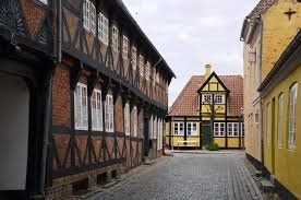
A visit to this museum gives you the impression that you have arrived in the time of HC Andersen. An environment has been created here with the typical Funen half-timbered houses, flowering gardens, village ponds and streets. The Funen open air museum has houses and farms from the period 1600-1800. For example, a forge, a watermill, windmill, rectory, school and poorhouse. Furthermore, agriculture is practiced according to old methods. In the summer, the museum comes alive, the farmers work in the fields, the houses are limewashed, the roofs thatched and the cook stirs the tiles of the rectory house, Tommerup præstegård. Take the picnic basket with you and enjoy the tranquility and wonderful atmosphere. There is a museum shop and a 'kro', a kind of inn on the site.
Den Fynske Landsby
Sejerskovvej 20
5260 Odense SA
Tlf: 65514601
museum.odense.dk/denfynskelandsby
Sejerskovvej 20, 5260 Odense, Denemarken
55° 21' 59.6" N 10° 23' 7.3" E
55.3665472 10.3853736
• Head south on Sejerskovvej. Go for 356 m.
• Turn right onto Stenløsevej. Go for 1.3 km.
• Take the 5th exit from roundabout onto E20 (Fynske Motorvej) toward København. Go for 24.3 km.
• Take exit 46 toward Nyborg V/Ørbæk/165. Go for 470 m.
• Turn left onto Hjulbyvej (8) toward Kerteminde/165/Nyborg C/160. Go for 1.0 km.
• Turn left onto Odensevej (160). Go for 2.0 km.
• Turn right onto Kertemindevej (165). Go for 87 m.
• Turn right onto Regstrupvej. Go for 4.0 km.
• Turn left onto Regstrupvej. Go for 278 m.
• Arrive at Regstrupvej. Your destination is on the left.
☍
33,8 km
( 24 min.)
Day
Margrietroute naar Nyborg
ROUTE 12 CROSS THROUGH FUNEN
Picking up the route in Odense: 1
1. Museum Tidens Samling (home furnishings / fashion)
2. Gudme Kirke
3. Lady stones (Denmark's largest boulder)
4. Ladby Labyskibet (Viking ship)
Walk in Kerteminde fishing village
5. Høkeren (museum shop)
(source Frits Mahn)
Grønnehave Strand Camping, Regstrupvej 83, 5800 Nyborg, Denemarken
Regstrupvej 83, 5800 Nyborg, Denemarken
55° 21' 31.4" N 10° 47' 11.4" E
55.3587302 10.7865024
• Head southwest on Regstrupvej. Go for 278 m.
• Turn slightly left onto Skaboeshusevej. Go for 3.1 km.
• Continue on Frisengårdsvej. Go for 626 m.
• Turn left onto Møllervej. Go for 97 m.
• Turn right onto Karseløkken. Go for 105 m.
• Arrive at Karseløkken.
☍
4,2 km
( 6 min.)
Nyborg, Denemarken
Walk through Nyborg
Nyborg is a small town on the east coast of Funen. We visited this city because it was one of the most important fortified cities in Denmark in the 17th century, next to Copenhagen and Frederica, due to its interesting location on the Great Belt. As early as the 12th century there was a castle here, Nyborg Slot, which still stands today. The later King Christian II was born in this castle. Meetings of the Danish Parliament took place here until the early 15th century.
In later centuries Nyborg became a fortified city, however in the 19th century some of the fortress walls were torn down to allow urban expansion. Nearby is now the Great Belt Bridge that connects Funen to Sjæland. Nyborg Church dates back to the 14th and 15th centuries, and the crucifix is all that remains of that time.
source: by car on vacation
5800 Nyborg, Denemarken
55° 19' 27" N 10° 47' 58.4" E
55.3241690 10.7995609
• Head toward Stentevej on Karseløkken. Go for 71 m.
• Turn right onto Stentevej. Go for 94 m.
• Turn left onto Frisengårdsvej. Go for 993 m.
• Turn left onto Vestergade (160). Go for 774 m.
• Turn left onto Havnegade (163). Go for 392 m.
• Take the 2nd exit from roundabout onto Storebæltsvej (163). Go for 947 m.
• Turn right and take ramp onto E20 (Fynske Motorvej) toward København. Go for 70.3 km.
• Take exit 35 toward Ringsted Ø/Roskilde/Haslev/269. Go for 448 m.
• Turn left onto Østre Ringvej (14) toward Roskilde/Benløse. Go for 987 m.
• Take the 2nd exit from roundabout onto Østre Ringvej (14) toward Roskilde. Go for 23.4 km.
• Turn left and take ramp onto 21 (Holbækmotorvejen) toward København. Go for 4.0 km.
• Take exit 11 toward Roskilde S Ø/Hillerød/6/Greve/217. Go for 959 m.
• Take the 1st exit from roundabout onto Østre Ringvej (6) toward Hillerød/Roskilde/O2. Go for 1.4 km.
• Continue on Østre Ringvej (6). Go for 885 m.
• Continue on Østre Ringvej (6). Go for 2.2 km.
• Turn left onto Frederiksborgvej toward Roskilde/Veddelev. Go for 259 m.
• Turn right onto Baunehøjvej. Go for 522 m.
• Turn left onto Baunehøjvej. Go for 626 m.
• Turn slightly right. Go for 117 m.
• Turn right. Go for 194 m.
• Arrive at your destination on the left.
☍
109,7 km
(1 hrs. 18 min.)
Day
Roskilde Camping, Baunehøjvej, Roskilde, Denemarken
Baunehøjvej 7, 4000 Roskilde, Denemarken
55° 40' 29.5" N 12° 4' 49.1" E
55.6748671 12.0803007
• Head west. Go for 194 m.
• Turn left toward Baunehøjvej. Go for 510 m.
• Continue on Baunehøjvej. Go for 233 m.
• Turn right onto Baunehøjvej. Go for 522 m.
• Turn right onto Frederiksborgvej. Go for 2.4 km.
• Take the 2nd exit from roundabout onto Frederiksborgvej. Go for 787 m.
• Take the 2nd exit from roundabout onto Sankt Ols Gade. Go for 107 m.
• Turn right onto Domkirkestræde. Go for 127 m.
• Turn left onto Domkirkepladsen. Go for 69 m.
• Arrive at Domkirkepladsen. Your destination is on the right.
☍
5,0 km
( 8 min.)
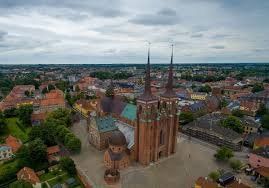
Roskilde Domkirke, Domkirkepladsen, Roskilde, Denemarken
Roskilde Dom - Roskilde Cathedral (UNESCO World Heritage)
Domkirkepladsen 3, 4000 Roskilde, Denmark
Roskilde Cathedral is perhaps the most famous church in Denmark. The cathedral is located in the center of Roskilde (Sjælland) and has been the final resting place of the Danish royals for centuries. Roskilde Cathedral is a UNESCO World Heritage Site.
From Viking kings like Harold Blauwtand (985 AD) and his son Sweyn Gaffelbaard (1014 AD) to 20th century King Christian X (1947 AD): they all have their own tomb in Roskilde Cathedral . A visit to the cathedral guarantees a special journey through the history of the Danish royal house.
It makes Roskilde Cathedral one of the highlights of a visit to the East Danish islands.
Location and opening hours Dom van Roskilde
Roskilde Cathedral is located in the center of the city, not far from the harbor and the Viking Ship Museum. The square next to the cathedral is a nice place for a summer terrace and overlooks the colorful shopping street of Roskilde.
source: Dansk.nl
Domkirkepladsen 3, 4000 Roskilde, Denemarken
55° 38' 33.5" N 12° 4' 49.6" E
55.6426377 12.0804491
• Head toward Fondens Bro on Domkirkepladsen. Go for 79 m.
• Continue on Bondetinget. Go for 207 m.
• Turn right onto Blågårdsstræde. Go for 28 m.
• Continue on Maglekildevej. Go for 301 m.
• Turn right onto Sankt Clara Vej (O1). Go for 390 m.
• Take the 3rd exit from roundabout onto Vindeboder. Go for 124 m.
• Arrive at Vindeboder. Your destination is on the left.
☍
1,1 km
( 2 min.)
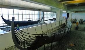
vikingemuseet, Vindeboder, Roskilde, Denemarken
The Viking ship museum in Roskilde
Around the year 1000, when five Viking ships were deliberately sunk at Skuldelev in Roskilde Fjord, life was difficult. The sunken ships blocked the main shipping channel and protected the capital of Denmark - then Roskilde - from attacks from the sea. The ships were uncovered in 1962. It turned out to be five different types of ships used by the Vikings as cargo or warships for their distant expeditions.
The Viking ships and the museum
The Viking ship museum overlooks the fjord and was built specifically for the five ships now on display in 1969. You can start with the introductory film "The Viking Ships". The different exhibitions tell the story of the ships, life at sea, the Vikings and the time in which they lived. In “The Viking Harbor” you can embark on warship and cargo ship imitations, giving you an excellent impression of life on board a Viking ship. The shop at the museum has an extensive range of books and counterfeit jewelery from the Viking times, etc.
The island and the harbor of the museum
After many years of planning, the Viking ship museum was expanded in 1997 with an island and harbor. The new island provides an interesting environment and the harbor is home to a unique collection of Nordic ships and simulated Viking ships. In the open space in front of the shipyard you can see how a traditional ship is built.
Be a Viking on board a Viking ship
The impressive collections of traditional Northern European ships in the Viking ship museum consist of successors to the Viking ships. Not only are they beautiful to look at - they are also great sailing ships. Sailing on an open, square rigged ship is a great experience, and you will get a sense of what it felt like to be a Viking on a Viking ship. During the summer holidays there are one-hour sailing trips every day. Special sailing trips for groups can be organized.
Havhingsten fra Glendalough - A Viking warship
Between 2000 and 2004, the Viking Museum shipyard built a reconstruction of Skuldelev 2, a 30-meter-long Viking ship. The ship has a crew of 60-70 men. The ship is currently being tested.
Viking ship museum
Vindeboder 12 4000 Roskilde Denmark Tel. +45 46 300 200 Fax +45 46 300 201 E-mail: museum (at) vikingeskibsmuseet.dk www.vikingeskibsmuseet.dk For more information, visit our English or Danish language website. Click here to watch a movie about the Viking Ship Museum.
source: vikingeskibetmuseet roskilde
4000, Vindeboder, 4000 Roskilde, Denemarken
55° 38' 55.4" N 12° 4' 43.6" E
55.6487096 12.0787886
• Head south on Vindeboder. Go for 68 m.
• Take the 4th exit from roundabout onto Sankt Clara Vej (O1). Go for 521 m.
• Pass 2 roundabouts and continue on Kong Valdemars Vej (O1). Go for 1.3 km.
• Turn left onto Københavnsvej (O1). Go for 137 m.
• Continue on Københavnsvej. Go for 1.4 km.
• Continue on Københavnsvej (156) toward København/21/Hedehusene. Go for 885 m.
• Take left ramp onto 21 (Holbækmotorvejen) toward København. Go for 14.3 km.
• Take the left exit toward København/E20ø/Lufthavn/E47n onto 21 (Holbækmotorvejen). Go for 5.5 km.
• Take the exit toward Helsingør onto E47 (Brøndby). Go for 3.1 km.
• Take exit 24 toward Roskildevej/Glostrup/Frederiksberg. Go for 724 m.
• Turn right onto Roskildevej (156) toward Brøndbyvester/Rødovre/Frederiksberg/København. Go for 655 m.
• Turn slightly left toward Roskildevej/156. Go for 81 m.
• Turn slightly left onto Korsdalsvej. Go for 182 m.
• Turn left onto Korsdalsvej. Go for 130 m.
• Turn right. Go for 23 m.
• Arrive at your destination on the right.
☍
28,9 km
( 22 min.)
Day
Dcu Camping Absalon, Korsdalsvej 132, Rødovre, Denemarken
Korsdalsvej 132, 2610 Rødovre, Denemarken
55° 40' 16.3" N 12° 26' 0.2" E
55.6711898 12.4333901
• Head south. Go for 23 m.
• Turn left onto Korsdalsvej. Go for 130 m.
• Turn right onto Korsdalsvej. Go for 127 m.
• Turn sharp left onto Roskildevej (156). Go for 5.3 km.
• Continue on Roskildevej. Go for 821 m.
• Continue on Vesterbrogade. Go for 2.1 km.
• Keep left onto Vesterbrogade. Go for 316 m.
• Turn right onto H. C. Andersens Boulevard toward E20/21/Lufthavn/Bella Center. Go for 365 m.
• Turn left onto Stormgade. Go for 309 m.
• Continue on Stormbroen. Go for 77 m.
• Continue on Vindebrogade. Go for 271 m.
• Continue on Børsgade. Go for 175 m.
• Turn left onto Holmens Kanal. Go for 311 m.
• Continue on Holbergsgade. Go for 386 m.
• Continue on Nyhavnsbroen. Go for 42 m.
• Arrive at Nyhavnsbroen. Your destination is on the left.
☍
10,8 km
( 19 min.)
Dag 1 Kobenhavn
walk through the storget (pgn 34)
lunch
Rosenborg Castle
dinner
Nyhavn Citadel and little mermaid
Day
København dag 2
Jewish Museum
Lunch
Christianshavn
Assistens cemetery
Nyhavn, København K, Denemarken
55° 40' 47.2" N 12° 35' 28.7" E
55.6797760 12.5913041
• Head toward Nyhavn on Nyhavnsbroen. Go for 42 m.
• Continue on Holbergsgade. Go for 386 m.
• Continue on Holmens Kanal. Go for 300 m.
• Turn right onto Børsgade. Go for 175 m.
• Continue on Vindebrogade. Go for 271 m.
• Continue on Stormbroen. Go for 77 m.
• Continue on Stormgade. Go for 309 m.
• Turn right onto H. C. Andersens Boulevard. Go for 278 m.
• Turn left. Go for 106 m.
• Arrive at your destination.
☍
1,9 km
( 4 min.)
Day
Dag 3
Tivoli
Tivoli is an amusement park in the center of Copenhagen and is located next to Københavns Hovedbanegård (Central Station) and close to Rådhuspladsen (City Hall Square). The park is well known outside of Denmark.
The attractions Vertigo and Dæmonen.
The Ferris wheel, one of the park's oldest attractions.
It was founded by Georg Carstensen in 1843, making it one of the oldest theme parks in the world ( Dyrehavsbakken Park , also in Copenhagen, is even older). The park was founded as a company, the shares of which were held by those involved in the construction.
On August 15, 1943, Tivoli celebrated its centenary and on that day with 112,802 visitors set a record for most visitors in a single day. In 1993, the one hundred and fifty-year anniversary was celebrated just as exuberantly.
Walt Disney visited this park in the 1950s to gain inspiration for the construction of the first Disney Park.
In 2000, the park won a Thea Award.
In the evening, Tivoli is lit with 115,000 energy-saving lamps. The park got its first bumper cars in 1926. And the park has a wooden roller coaster built in 1914, making it one of the oldest wooden roller coasters still in operation in the world.
Tivoli is the most visited theme park in Denmark: 4,640,000 people visited the park in 2016. [1]
A ticket must be purchased before entering the park. Separate tickets or day tickets must be purchased for entrance to attractions. In the latter case, the visitor is given a paper bracelet.
In addition to attractions, there are several dining options, playgrounds, lawns and live entertainment. In the summer months there is a stage in the park where concerts are given.
source: wikipedia
Vesterbrogade 3, 1630 København V, Denemarken
55° 40' 25.3" N 12° 34' 5.3" E
55.6736841 12.5681471
• Head toward H. C. Andersens Boulevard. Go for 106 m.
• Turn right onto H. C. Andersens Boulevard. Go for 278 m.
• Turn left onto Stormgade. Go for 309 m.
• Turn right onto Frederiksholms Kanal. Go for 94 m.
• Turn left onto Marmorbroen. Go for 62 m.
• Turn right onto Christiansborg Ridebane. Go for 200 m.
• Turn right onto Christiansborg Ridebane. Go for 91 m.
• Arrive at Christiansborg Ridebane. Your destination is on the right.
☍
1,1 km
( 3 min.)
Wandeling langs Christiansborg, Prins Jørgens Gård, Kopenhagen, Denemarken
Christiansborg in 1794
Christiansborg (Danish: Christiansborg Slot) is a palace on the island of Slotsholmen in central Copenhagen.
The building houses the Danish Parliament (Folketing), the Danish Supreme Court (Højesteret) and the office of the Prime Minister of Denmark (Statsministeriet). Various parts of the palace, including the Royal Reception Hall, the Palace Chapel and the Royal Stables, are also used by the Danish Royal Family.
Christiansborg is on the spot where Bishop Absalon built a castle in 1167. The ruins of this castle can still be visited in the basement of Christiansborg. After the castle of Absalon was destroyed by the Hanseatic League in 1369, a new castle was built on the site. The Blue Tower of this castle was used as a prison.
This castle was finally demolished around 1730 by King Christian VI. He then had the first Christiansborg built by the architect Elias David Häusser, which he used as his royal palace. In 1794 this Christiansborg went up in flames, after which the second Christiansborg was built, which was designed by architect Christian Frederik Hansen and was finished in 1828. However, court life had already moved to Amalienborg at the time and made no sense to move back. The lock was still owned by the king.
In 1848, Christiansborg was the scene of the protests that resulted in Denmark's first democratic constitution. The king then gave up several rooms to the parliament, which was then still called Rigsdagen (until 1953).
The second Christiansborg also burned down in 1884, after which the rebuilding of a third Christiansborg Castle in the style of the neo-baroque started in 1906. After a competition between architects, the commission was given to Thorvald Jørgensen.
source: wikipedia
Prins Jørgens Gård 1, 1218 København, Denemarken
55° 40' 34.4" N 12° 34' 49.9" E
55.6762316 12.5805143
• Head southwest on Christiansborg Ridebane. Go for 91 m.
• Turn right onto Christiansborg Ridebane. Go for 203 m.
• Turn right onto Marmorbroen. Go for 62 m.
• Turn left onto Frederiksholms Kanal. Go for 91 m.
• Turn left onto Prinsens Bro. Go for 45 m.
• Turn right onto Frederiksholms Kanal. Go for 242 m.
• Turn right onto Christians Brygge (O2). Go for 3.3 km.
• Continue on Scandiagade toward Malmø/E20/Lufthavn/Odense/E47/Bella Center. Go for 372 m.
• Continue on Sydhavnsgade. Go for 510 m.
• Continue on Sjællandsbroen. Go for 832 m.
• Keep right onto Centrumforbindelsen toward Odense/E20/E47/E55/Malmø/Lufthavn. Go for 829 m.
• Take left ramp onto E20 (Amagermotorvejen) toward Odense/E47/E55/21. Go for 35.8 km.
• Keep right onto E47/E55 (Køge Vest) toward Rødby/Gedser. Go for 57.9 km.
• Take exit 41 toward Vordingborg/Møn. Go for 408 m.
• Turn left onto Mønsvej (22/59) toward Møn/Kalvehave. Go for 806 m.
• Take the 2nd exit from roundabout onto Kalvehavevej (59). Go for 10.0 km.
• Take the 2nd exit from roundabout onto Præstøvej (59). Go for 10.1 km.
• Continue on 59/287. Go for 121 m.
• Continue on Storegade (287). Go for 1.3 km.
• Continue on Klintevej (287). Go for 5.5 km.
• Turn right toward Søndre Landevej. Go for 41 m.
• Continue on Søndre Landevej. Go for 7.4 km.
• Turn right onto Klintholm Havnevej. Go for 1.9 km.
• Turn slightly right onto Thyravej. Go for 13 m.
• Turn slightly right onto Thyravej. Go for 196 m.
• Turn left onto Klintholm Havneby. Go for 169 m.
• Arrive at Klintholm Havneby. Your destination is on the right.
☍
138,2 km
(1 hrs. 38 min.)
Day
Via de Margriet route naar Mons Klint
ROUTE 03 EAST AND SOUTH SEELAND
We pick up in Koge
1. Skt. Nicolaj Kirke
2. Store Heddinge Kirke
3. Højerup Stevns Klint (chalk and limestone cliffs
4. Faxe (Fakse) Kalkbrud (lime quarry and museum)
5. Skt. Peders Kirke
6. Skt. Mortens Kirke
7. Helligåndshuset (holy spirit house)
8. Jungshoved Slotsbanke (Castle Hill)
9. Gåsetårnet (goose tower)
source: Frits Mahn
Klintholm Havn, Klintholm Havneby, Borre, Denemarken
Klintholm Havneby 24a, 4791 Borre, Denemarken
54° 57' 10.6" N 12° 27' 54.7" E
54.9529437 12.4651845
• Head toward Thyravej on Klintholm Havneby. Go for 169 m.
• Turn right onto Thyravej. Go for 209 m.
• Turn slightly left onto Klintholm Havnevej. Go for 3.7 km.
• Turn right onto Klintevej (287). Go for 2.8 km.
• Turn left onto Langebjergvej. Go for 328 m.
• Arrive at Langebjergvej.
☍
7,1 km
( 11 min.)
Møns Klint, Borre, Denemarken
Anneleen wrote in 2019:
To visit the beach of Møns Klint you can park at the Geocenter (35 DKK). In the geocenter you can take part in an exhibition about the origins of Denmark, admire the first dinosaurs that were found there and watch a 3D film. But be especially surprised by the cliffs and the beach that await you.
You reach the beach via a wooden staircase. There are many steps and the stairs are sometimes very steep. But the beach is well worth the effort. The beach is full of stones large and small, and everyone searches for fossils in the pinstripes. Fun for the kids! But don't forget to look up every now and then for a breathtaking view of the limestone cliffs of Møns Klint! Occasionally rest a bit on washed-up driftwood and walk on to the next set of stairs.
You choose how long you want to take the walk, and can climb up again when you reach the next staircase on the beach. A decent climb awaits you, but the effort at the top is well worth the effort. You walk back along the edge of the cliffs in the direction of the Geocenter. From above you can enjoy a beautiful view of the beach, the azure blue sea and the white cliffs.
Come especially in the morning, when the sun makes the cliffs beautifully white and there are fewer visitors. Be sure to put on walking shoes and bring drinks and a bag for the fossils found.
The Geocenter also has a café and toilets, but you can also have a picnic. You can also take a height trail, horseback riding, mountain biking, forest walking and more.
source: tripadvisor anneleen
4791 Borre, Denemarken
54° 59' 2.9" N 12° 32' 37.3" E
54.9841290 12.5437017
• Head south on Langebjergvej. Go for 328 m.
• Turn right onto Klintevej (287). Go for 15.8 km.
• Continue on Storegade (287). Go for 1.3 km.
• Continue on 59/287. Go for 121 m.
• Continue on Støvvasen (59/287). Go for 4.4 km.
• Continue on Kostervej (59). Go for 5.7 km.
• Take the 3rd exit from roundabout onto Ny Vordingborgvej (59). Go for 10.0 km.
• Take the 2nd exit from roundabout onto Mønsvej (59). Go for 658 m.
• Turn right and take ramp onto E47/E55 (Sydmotorvejen) toward København. Go for 15.3 km.
• Take exit 39 toward Bårse/Næstved. Go for 504 m.
• Turn right onto Præstø Landevej (265) toward Næstved. Go for 11.9 km.
• Take the 1st exit from roundabout onto Ring Øst (O2) toward 54/Næstved N. Go for 3.3 km.
• Take the 2nd exit from roundabout onto Ring Øst (O2) toward Rønnede/54. Go for 1.5 km.
• Take the 2nd exit from roundabout onto Ring Øst (O2) toward Rønnede/54. Go for 1.5 km.
• Take the 3rd exit from roundabout onto Ring Nord (54) toward Ringsted/14. Go for 7.1 km.
• Take the 1st exit from roundabout onto Slagelsevej (22) toward Slagelse. Go for 12.8 km.
• Pass 2 roundabouts and continue on Slagelsevej (22). Go for 14.8 km.
• Take the 2nd exit from roundabout onto Omfartsvejen (22) toward Kalundborg/E20V. Go for 2.8 km.
• Take the 2nd exit from roundabout onto Omfartsvejen (22) toward Kalundborg/E20. Go for 501 m.
• Turn left and take ramp onto E20 (Vestmotorvejen) toward Odense. Go for 68.4 km.
• Take exit 52 toward Odense SV/Assens onto 168 (Assensvej). Go for 6.9 km.
• Pass 3 roundabouts and continue on Assensvej (168). Go for 25.3 km.
• Take the 3rd exit from roundabout onto Østre Ringvej (313). Go for 1.0 km.
• Take the 2nd exit from roundabout onto Søndre Ringvej. Go for 1.8 km.
• Turn left onto Næsvej. Go for 132 m.
• Turn slightly right. Go for 420 m.
• Turn left toward Næsvej. Go for 24 m.
• Turn right onto Næsvej. Go for 195 m.
• Arrive at Næsvej. Your destination is on the left.
☍
214,7 km
(2 hrs. 45 min.)
Day
Margrietroute zuid Funen
ROUTE 05 LANGELAND AND SOUTH FUNEN 147 km
We pick up in Svenborg:
at the Langelands bridge
1. Søfartmuseum (maritime museum)
2. Svendborg og Omegns Museum (regional museum)
3. Vester Skerninge
4. Faaborg Kaleko Mølle (mill and museum)
Faaborg:
5. Museum Den Gåmle Gard
Horne Kirke
(source Frits Mahn)
Assens Marina, Næsvej 29, Assens, Denemarken
Næsvej 29, 5610 Assens, Denemarken
55° 16' 5" N 9° 53' 1" E
55.2680587 9.8836041
• Head north on Næsvej. Go for 8 m.
• Turn right. Go for 23 m.
• Turn right toward Næsvej. Go for 626 m.
• Turn slightly left onto Næsvej. Go for 132 m.
• Turn right onto Søndre Ringvej. Go for 1.8 km.
• Take the 2nd exit from roundabout onto Østre Ringvej (313). Go for 994 m.
• Take the 2nd exit from roundabout onto Østre Ringvej (307/313). Go for 3.5 km.
• Continue on Middelfartvej (313). Go for 3.5 km.
• Turn left onto Sandager Kirkevej. Go for 958 m.
• Turn left onto Baunevej. Go for 2.0 km.
• Turn right onto Strandgårdsvej. Go for 778 m.
• Turn right. Go for 35 m.
• Arrive at your destination on the left.
☍
14,4 km
( 18 min.)
Sandager Næs Camping
Strandgårdsvej 12, 5610, Assens, Dänemark
55° 20' 3.1" N 9° 53' 24" E
55.3342000 9.8900000
• Head south. Go for 35 m.
• Turn left onto Strandgårdsvej. Go for 778 m.
• Turn left onto Baunevej. Go for 2.0 km.
• Turn right onto Sandager Kirkevej. Go for 958 m.
• Turn left onto Middelfartvej (313). Go for 18.7 km.
• Take the 2nd exit from roundabout onto Hedegaardsvej (313/317). Go for 435 m.
• Take the 3rd exit from roundabout onto E20 (Fynske Motorvej) toward Kolding/Middelfart. Go for 17.1 km.
• Keep right onto E20 (Fredericia) toward Aarhus/E45n/Vejle. Go for 9.2 km.
• Continue on E45 (Østjyske Motorvej). Go for 67.8 km.
• Keep right onto 501 (Aarhus Syd) toward Aarhus C - S/Havn. Go for 9.5 km.
• Continue on Åhavevej. Go for 925 m.
• Continue on Marselis Boulevard. Go for 1.9 km.
• Keep right onto Marselis Boulevard (O1) toward Sjællands Odde. Go for 238 m.
• Turn right onto Strandvejen. Go for 280 m.
• Turn left onto Sumatravej. Go for 37 m.
• Turn right onto Marselisborg Havnevej. Go for 401 m.
• Arrive at Marselisborg Havnevej. Your destination is on the left.
☍
130,3 km
(1 hrs. 28 min.)
Day
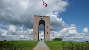
Lunchen bij Ejer Bavnehoj
At the top is a 13-meter high tower, built in 1924, commemorating the reunification of southern Jutland with the rest of Denmark after the First World War.
Near Ejer Bavnehøj is Yding Skovhøj, another highlight, reaching 172.66 m above sea level, but this includes a man-built Bronze Age burial mound. Without the Bronze Age Hill, Yding Skovhøj is slightly lower than Denmark's highest man-made point, Møllehøj, which is 170.86 m high, 51 cm higher than Ejer Bavnehøj.
The tower of Ejer Bavnehøj
Historically, Ejer Bavnehøj was best known as a beacon location where signal fires were lit to alert the military and locals when the enemy was on the way. [1] The second part of the name, "Bavnehøj", can literally be translated into "Beacon Hill" ( bavne means "beacon" and høj , from the Old Norse word haugr , meaning hill).
source: wikipedia
Marselisborg Havnevej, Aarhus, Denemarken
Marselisborg Havnevej 54, 8000 Aarhus C, Midtjylland / Denmark
Tel .: +4586198644 | Email: mh@marselisborghavn.dk |
GPS:
N 56.13939, E 10.21902
N 56 ° 08'22 ", E 10 ° 13'08"
Marselisborg Havnevej, 8000 Aarhus, Denemarken
56° 8' 21.2" N 10° 12' 48.1" E
56.1392359 10.2133719
• Head southwest on Marselisborg Havnevej. Go for 401 m.
• Turn left onto Sumatravej. Go for 37 m.
• Turn right onto Strandvejen. Go for 1.3 km.
• Turn left onto Sønder Allé. Go for 451 m.
• Continue on Rådhuspladsen. Go for 96 m.
• Continue on Vester Allé. Go for 305 m.
• Turn left onto Thorvaldsensgade. Go for 418 m.
• Turn left onto Silkeborgvej. Go for 32 m.
• Turn right onto Viborgvej. Go for 293 m.
• Arrive at Viborgvej.
☍
3,4 km
( 7 min.)
Day
Aarhus
Besaettelsesmuseet
The Occupation Museum (Danish: Besættelsesmuseet ) in Aarhus, Denmark is a historical museum dedicated to the history of Aarhus during Germany's occupation during World War II. The museum is located in the historic center, the Latin Quarter, in Midtbyen and shares the building of the Women's Museum. Listed as a Historic Monument, the building is the city's former town hall and police station, built in 1856-57. During the war, it served as Gestapo headquarters for Jutland, after the university buildings where the Gestapo was previously housed were destroyed by the Royal Air Force in an airstrike. [1]
Occupation Museum
Besættelsesmuseet
The facade of the occupation museum
The focus of the museum is on major events in Aarhus during the war, notably the Aarhus Air Raid, the 1944 explosion at Aarhus harbor, the activities of the prolific informant Grethe Bartram and the resistance movement in general. The museum exhibition uses the building's history as a place of interrogation and torture to tell the story of the war events. The cells are furnished with original items and equipment and the instruments of torture used at the time can be seen. The exhibition contains an extensive range of items from the 1940-45 period, such as uniforms, weapons, mines, tools, passes and German, English and Danish propaganda
source: wikipedia
Day
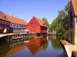
Den Gamle By, Viborgvej, Aarhus C, Denemarken
Den Gamle By (literally: The Old Town ) is an open-air museum in Aarhus. It is located amid the Aarhus Botanical Gardens and includes 75 historic buildings from 20 municipalities across the country.
Street in Den Gamle By
The museum opened in 1914, making it the first open-air museum of its kind in the world. There were already open-air museums that represent rural culture. The initiative was taken by Peter Holm. This was prompted by the intended demolition of the Mayor's House ( Borgmestergård ) in Aarhus, which had fallen into disuse in 1908, which was built in Renaissance style (1597). It was not destroyed at Holm's initiative, but disassembled and stored for later use. In 1909, it was rebuilt on the site of the then Danish National Exhibition, where it was used for historical exhibitions. There was also a pavilion at that exhibition, which moved to the museum in 2009. It was rebuilt in another place in 1914 and has since been the main building of the museum, which opened in the same year under the name: Den gamle Borgmestergård (the old mayor's house). Since then, the museum has gradually expanded. In 1923 a complex of eight merchant houses from Aalborg (1723) threatened to be demolished. These houses were also transferred to the museum, after which the museum acquired its current name. In the following years, the museum acquired various buildings threatened with demolition from twenty municipalities spread across Denmark.
The Danish initiative was followed in several other countries.
Present day:
Style room in the Burgemeestershuis
At the moment (2015) Den Gamle By has 75 buildings, while three more buildings are stored awaiting rebuilding. The oldest is a warehouse from Aalborg from about 1550, and the youngest is the already mentioned pavilion from 1909. There are some large buildings, including the Muntmeesterhuis from Copenhagen (1683), the already mentioned Mayor's house and the merchant houses. In addition, there are numerous smaller houses, most of which are designed as half-timbered houses. In addition, there are some commercial buildings such as a small shipyard, a tobacco shed, shops and the like. Some wind and water mills are also present. Various old crafts are practiced here and there.
There are also five permanent exhibitions: The Toy Museum, the Watch Museum, the Textile Museum, and permanent exhibitions of silverware and pottery, respectively.
There are five gardens, which are reconstructions for gardens in the mid-17th to early 20th century. It concerns a Renaissance garden (1647), a garden from 1864 which served a wealthy family as a vegetable garden and relaxation, a garden from 1910, a garden with medicinal plants from about 1750, and a commercial garden in which the flowers are grown elsewhere in the museum are for sale.
A post office, a bookstore, a bakery and a few cafes and restaurants complete the whole, creating the illusion of being a real town.
source: wikipedia
In the afternoon we drive to Store Sjorup
Viborgvej 2, 8000 Aarhus C, Denemarken
56° 9' 31.6" N 10° 11' 31.6" E
56.1587826 10.1921152
• Head northwest on Viborgvej. Go for 438 m.
• Turn right onto Vestre Ringgade (O1). Go for 1.5 km.
• Turn left onto Langelandsgade. Go for 498 m.
• Turn left onto Randersvej. Go for 4.0 km.
• Take ramp onto Randersvej (180) toward Lisbjerg/Lufthavn/15/Grenaa. Go for 878 m.
• Turn right and take ramp onto 15 (Djurslandmotorvejen) toward Grenaa/Lufthavn. Go for 31.6 km.
• Turn right onto Ebeltoftvej (21) toward Ebeltoft/Færge. Go for 13.1 km.
• Turn left onto Jernbanegade. Go for 116 m.
• Turn right onto Adelgade. Go for 216 m.
• Turn slightly left onto Overgade. Go for 202 m.
• Arrive at Overgade. Your destination is on the left.
☍
52,5 km
( 41 min.)
Day
Ebeltoft, Denemarken
8400 Ebeltoft, Denemarken
56° 11' 46.8" N 10° 40' 40.3" E
56.1963270 10.6778570
• Head south on Overgade. Go for 4 m.
• Turn right onto Villadsgyde. Go for 171 m.
• Turn right onto Nedergade. Go for 112 m.
• Turn left onto Toldbodvej. Go for 83 m.
• Turn right onto Strandvejen (21). Go for 5.3 km.
• Turn right onto Ebeltoftvej toward Stubbe Sø. Go for 7.2 km.
• Turn right onto Århusvej (15) toward Grenaa. Go for 15.4 km.
• Turn right onto Trekanten. Go for 215 m.
• Continue on Fuglsangvej. Go for 2.3 km.
• Turn right onto Fuglsangvej. Go for 96 m.
• Turn right. Go for 41 m.
• Arrive at your destination on the left.
☍
30,9 km
( 28 min.)
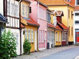
Te doen
Ebeltoft is a colorful village full of shops, galleries and eateries. The narrow streets with the typical Danish houses are very cozy, especially during the summer months. In the harbor there is plenty to do on and around the recreated ship the Fregatten Jylland. The Glass Museum and the historical museum in the old town hall are also worth a visit.
Grenaa Strand Camping, Fuglsangvej, Grenaa, Denemarken
Fuglsangvej 58, 8500 Grenå, Denemarken
56° 23' 20.1" N 10° 54' 44" E
56.3889059 10.9122191
• Head northeast. Go for 41 m.
• Turn left onto Fuglsangvej. Go for 96 m.
• Turn left onto Fuglsangvej. Go for 2.3 km.
• Continue on Trekanten. Go for 215 m.
• Turn right onto Århusvej (15). Go for 1.9 km.
• Turn left onto Ringvejen (16) toward Randers/Grenaa N-V. Go for 2.8 km.
• Pass 3 roundabouts and continue on 16/21. Go for 44.8 km.
• Take ramp onto Grenåvej toward 46/Silkeborg/Randers. Go for 4.0 km.
• Keep right onto Grenåvej. Go for 3.1 km.
• Turn sharp right onto Randersbro (180) toward 16/507/Viborg/Hadsund/Nordhavn. Go for 279 m.
• Turn right onto Havnegade (O1) toward Hospital/Nordhavn. Go for 453 m.
• Continue on Rosenørnsgade (O1). Go for 295 m.
• Continue on Udbyhøjvej (O1). Go for 57 m.
• Take the 2nd exit from roundabout onto Østervangsvej. Go for 1.1 km.
• Continue on Hadsundvej. Go for 1.2 km.
• Pass 3 roundabouts and continue on Himmerlandsgade (507/541). Go for 28.6 km.
• Continue on Himmerlandsgade (507). Go for 247 m.
• Turn right onto Hornbechsvej. Go for 303 m.
• Turn left onto Nørregade. Go for 259 m.
• Continue on Ålborgvej. Go for 22 m.
• Turn right onto Rosenhøj. Go for 111 m.
• Arrive at Rosenhøj. Your destination is on the right.
☍
92,1 km
(1 hrs. 23 min.)
Day
Hadsund, Denemarken
9560 Hadsund, Denemarken
56° 43' 17.2" N 10° 6' 46.4" E
56.7214370 10.1128970
• Head south on Rosenhøj. Go for 111 m.
• Turn left onto Ålborgvej. Go for 22 m.
• Continue on Nørregade. Go for 259 m.
• Turn left onto Østergade. Go for 1.7 km.
• Turn right onto Industriparken. Go for 41 m.
• Take the 3rd exit from roundabout onto Alsvej (541). Go for 8.4 km.
• Continue on Hadsundvej (541). Go for 2.0 km.
• Continue on Øster Hurupvej (541). Go for 1.8 km.
• Continue on Kystvejen (541). Go for 4.5 km.
• Continue on Dokkedalvej (541). Go for 5.3 km.
• Continue on Kystvej (541). Go for 11.9 km.
• Arrive at Kystvej (541). Your destination is on the left.
☍
36,0 km
( 35 min.)
Egense, Denemarken
9280 Egense, Denemarken
56° 57' 43.1" N 10° 16' 9.9" E
56.9619730 10.2694030
• Head toward Østergade on Kystvej (541). Go for 3.8 km.
• Take the Egense-Hals Ferry. Stay on for 540 m.
• Head toward Strandgade on Færgevej (541). Go for 318 m.
• Turn left onto Østergade (541). Go for 527 m.
• Turn left onto Tværgade. Go for 45 m.
• Arrive at Tværgade. Your destination is on the left.
☍
5,2 km
( 37 min.)
Hals, Denemarken
9370 Hals, Denemarken
56° 59' 47.9" N 10° 18' 31" E
56.9966360 10.3086089
• Head west on Tværgade. Go for 9 m.
• Turn right onto Toften. Go for 168 m.
• Turn left onto Østergade (541). Go for 94 m.
• Take the 1st exit from roundabout onto Strandvejen (541). Go for 18.8 km.
• Turn right onto Skippergade (541). Go for 33 m.
• Turn left onto Sæbyvej (541). Go for 8.5 km.
• Arrive at Østkystvejen (541). Your destination is on the left.
☍
27,6 km
( 26 min.)
Voerså, Denemarken
9300 Voerså, Denemarken
57° 12' 30.3" N 10° 29' 10.8" E
57.2084060 10.4863460
• Head toward Havnevej on Østkystvejen (541). Go for 13.3 km.
• Take the 3rd exit from roundabout onto Ålborgvej (180/541). Go for 2.1 km.
• Take the 1st exit from roundabout onto E45 (Frederikshavnmotorvejen) toward Frederikshavn. Go for 15.0 km.
• Continue on Havnepladsen (35/40). Go for 1.7 km.
• Continue on Skagensvej (40) toward Skagen. Go for 1.9 km.
• Pass 6 roundabouts and continue on Ålbækvej (40). Go for 34.2 km.
• Continue on Frederikshavnsvej (40). Go for 1.7 km.
• Take the 2nd exit from roundabout onto Kattegatvej. Go for 652 m.
• Turn left onto Buttervej. Go for 365 m.
• Take the 2nd exit from roundabout onto Bøjlevejen. Go for 3.3 km.
• Take the 2nd exit from roundabout onto Fyrvej (40). Go for 1.8 km.
• Take the 2nd exit from roundabout onto Åkandevej. Go for 200 m.
• Turn slightly right onto Åkandevej. Go for 69 m.
• Arrive at Åkandevej.
☍
76,2 km
(1 hrs. 7 min.)
Onderweg deel Margrietroute
1. Saeby: There is plenty to do in Sæby. The old center is full of colorful houses, cozy shops and restaurants. The medieval farm Herregeardsmuseet Sæbygård and the 18th century water mill are also worth a visit. Miniby Sæby, the 'madurodam' of Sæby, also gives a nice look back in time. A group of volunteers made an impressive reconstruction of Sæby around 1900.
2. Den Tilsandede Kirke
3. Skagen
4. Pine
5. Bunker museum set
Grenen Kunstmuseum, Fyrvej, Skagen, Denemarken
Pine Art Museum
Fyrvej 40, 9990 Skagen, Nordjylland / Denmark
Tel .: +4598442288 | Second telephone number: +4529784981
GPS:
N 57.73928, E 10.63294
N 57 ° 44'21 ", E 10 ° 37'59"
Fyrvej 40, 9990 Skagen, Denemarken
57° 44' 23" N 10° 38' 2.4" E
57.7397327 10.6340039
• Head southwest on Åkandevej. Go for 180 m.
• Take the 1st exit from roundabout onto Fyrvej (40). Go for 1.5 km.
• Arrive at Fyrvej (40). Your destination is on the left.
☍
1,6 km
( 3 min.)
CampOne Grenen Strand, Fyrvej, Skagen, Denemarken
Fyrvej 16, 9990 Skagen, Denemarken
57° 43' 52.5" N 10° 36' 50.3" E
57.7312480 10.6139640
• Head southwest on Fyrvej (40). Go for 323 m.
• Take the 1st exit from roundabout onto Bøjlevejen. Go for 3.3 km.
• Take the 3rd exit from roundabout onto Buttervej. Go for 428 m.
• Turn right onto Kattegatvej. Go for 563 m.
• Take the 1st exit from roundabout onto Frederikshavnsvej (40). Go for 10.9 km.
• Take the 2nd exit from roundabout onto Ålbækvej (40). Go for 6.4 km.
• Take the 1st exit from roundabout onto Hirtshalsvej (597). Go for 15.3 km.
• Take the 2nd exit from roundabout onto Skagensvej (597). Go for 10.6 km.
• Take the 3rd exit from roundabout onto E39 (Hirtshalsmotorvejen) toward Aalborg. Go for 57.1 km.
• Continue on Vendsyssel. Go for 221 m.
• Continue on E45 (Vendsyssel). Go for 1.1 km.
• Take exit 21 toward Nørresundby N/Nørresundby C/Lindholm. Go for 392 m.
• Turn right toward Nørresundby C. Go for 97 m.
• Continue on Sundsholmen. Go for 180 m.
• Turn left onto Hjørringvej (180) toward Nørresundby C. Go for 3.2 km.
• Turn left onto Vingårdsgade. Go for 282 m.
• Continue on Brandstrupsgade. Go for 137 m.
• Turn slightly left onto Møllegade. Go for 60 m.
• Arrive at Møllegade. Your destination is on the left.
☍
110,6 km
(1 hrs. 17 min.)
Day
Stop in Aalborg
Parking Graveyard address: kong christiansalle 60 Aarhus Of Aldi
Gråbrødrekloster Museet, Algade, Aalborg, Denemarken
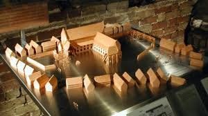
Three meters below Aalborg's busiest shopping street, the Algade, you will find the underground Gråbrødrekloster Museum. Get to know the history of the Franciscan monastery and learn more about the market square and the unknown churches and houses that had to be demolished in order to build the monastic monastery.
See the impressive ruin of the monastery, the skeletons of the cemetery, where the deceased were buried in layers, and the beautiful finds from medieval Aalborg and Viking times.
Gråbrødrekloster Museet
Algade 19
9000 Aalborg
source: Gråbrødrekloster Museet
Algade 19, 9000 Aalborg, Denemarken
57° 2' 50" N 9° 55' 18.9" E
57.0472103 9.9219058
• Head south on Møllegade. Go for 45 m.
• Turn right onto Skipper Clements Gade. Go for 138 m.
• Turn right onto Boulevarden. Go for 46 m.
• Turn left onto Algade. Go for 148 m.
• Turn right onto Adelgade. Go for 216 m.
• Arrive at Adelgade. Your destination is on the left.
☍
0,6 km
( 1 min.)
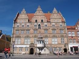
Jens Bangs Stenhus, Østerågade, Aalborg, Denemarken
Exterior view of Jens Bang's House
Jens Bang's House (Danish: Jens Bangs Stenhus ; translated: "Jens Bang's Stone House") is a landmark in Aalborg, Denmark. Located on the Østerågade in Nytorv Square, it was built in 1624 by Jens Bang in Dutch Renaissance style. Known for its facades and carved auricular window decoration, it is said to be the finest privately owned Renaissance building in the country. It also features gargoyles and a sculpture of Bang's face, sticking out tongue. [1] The five-story building has been home to the city's oldest pharmacy for over 300 years. [2] It is privately owned. [3]
Jens Bang, remembered as one of the richest citizens of Denmark, was born in Horsens. Sidsel Jørgensdatter's son at her second marriage to Oluf Bang, he was therefore the half-brother of Aalborg Mayor Jørgen Olufsen, who had already built a mansion higher up Østerå Street. After arriving in Aalborg in 1600, Bang joined the city's merchant guild, Guds Legems Lav . Five years later, he obtained the status of recognized trader. Over the next 20 years, he was so lucky and successful in his business that he became one of the most important traders in the country and certainly the most prosperous trader in Aalborg. Surprisingly, Bang did not take any responsibility in the city council, possibly because he didn't like that, but the more likely aggressive attitude prevented him from doing so. He was an unparalleled facilitator, hating his contemporaries to the point of being involved in physical combat. On the plus side, he founded a branch in 1637 with his wife, offering accommodation for 26 paupers. In 1623, Bang Københavns inherited gård , a large old estate in Aalborg, on the corner of Østerå and Adelsgade. After demolishing most of the old buildings, he built a huge residence and completed it the following year. [4]
Architecture
The house is said to be the finest independent Renaissance mansion in Denmark, comparable only to the home of Mattias Hansen on the Amagertorv in Copenhagen. The latter has only three floors and two facades, while Jens Bang's House has four main floors and three facades, also with floor space and rooms. The house is decorated with sculpted masonry of the same high quality as Christian IV's buildings. As a result of Bang's excellent relationship with the king, he was undoubtedly able to appeal to the best designers and craftsmen of the time, possibly employing Hans van Steenwinckel de Jonge as his architect. Jørgen Olufsen's house on the same street is hardly comparable. [4]
The house originally had five round arched doors, likely topped by some of the carved figures and gargoyles now crowning the windows. The ground floor was used for trading stands and warehousing. In addition to the living rooms on the first floor, there were also warehouses in the building. Bang's private rooms on the first floor were lit by a row of huge sandstone-framed windows, some single, others double without any regularity. Their round arches are decorated with angels and gargoyles in the auricular baroque style. [4]
The protruding bay in the center of the facade was certainly once the main entrance, located on the first floor with stairs from the street. With its intricately carved figures and decorations, the portal is a true masterpiece. It clearly shows the year 1623, but the plaque at the top, where the original owner once had his name, now bears the mirrored monograms of the pharmacist CL Rübner and his wife. Christian VI's monogrammed weapon, flanked by swans, must have once displayed that of Christian IV. On the third floor, where there was also living space, the windows are smaller and simpler. The fourth floor has double, round curved window frames, surmounted by a cornice with decorative strips and spiers. In the center is a large hatch, probably added later. Together with the loft, the floor was formerly used as a warehouse. The three high gables are decorated with the most beautiful baroque ornaments from that period and reflect the very best examples of Dutch design. [4]
Additions and changes
The half-timbered bay with its fine pebble spire and the figure of Fortuna dates from around 1700. Around 1712 there were a number of other changes: in addition to modifications to the main entrance and adjacent windows, finely plastered baroque ceilings were added to two of the rooms on the first floor , probably at the initiative of Johannes-Friedenreich. The top of the south facade was replaced for some time by a hip roof, but was rebuilt in 1916 during extensive restoration work under Harald Lønborg-Jensen. In 1897, a stair tower was built at the back of the house to replace an internal staircase. Among the additional buildings of the property on Adelgade and Cortesgyde, one of the south wing rooms has a late Gothic vaulted ceiling preserved from Københavns gård . [4]
Property
A 1890 street scene of the facade and adjacent buildings.
During the Thirty Years' War, the house was occupied by the Germans from 1627 to 1629, while Jens Bang fled to Marstrand awaiting their departure. Bang died in 1644 during the Torstenson War when Aalborg was re-occupied. This time, the troops left his home in a bad state. Since Bang had no direct descendants, ownership of the house was shared among a number of heirs until in 1671 the pharmacist Johannes Friederich bought the buildings and opened his Swaneapotek (Swan Pharmacy) there. The pharmacy has been around ever since and the building has been passed down from generation to generation, the Strøybergs inherited it in 1829. [4]
The building is owned by the fund "Apoteker SC Strøybergs Fond til Bevarelse af Jens Bangs Stenhus". [5]
Apotekersamlingen
The Svaneapotek (Swan Pharmacy) collection is now housed in one of the upper rooms, as a small pharmacy museum known as Apotekersamlingen. In buildings open to visitors, the shelves feature beautiful old containers and equipment, including a container used to mix 70 ingredients to make the sauce , which would have been effective in fortifying the weak. Jars with herbs and medicines and tools for the production of pills can be seen, which proves the history of the pharmacy in the past 300 years. Initially, the pharmacy was also a grocery store licensed to sell spirits, wine, chocolate and liquorice, which was also used for medicinal purposes. [6]
Apotekersamlingen is managed by the Historical Museum of North Jutland, but is owned by the same fund that owns the building. [5]
source: Wikipedia
Østerågade 9, 9000 Aalborg, Denemarken
57° 2' 54.3" N 9° 55' 15.6" E
57.0484074 9.9210026
• Head toward Østerågade on Adelgade. Go for 15 m.
• Turn right onto Østerågade. Go for 95 m.
• Turn right onto Algade. Go for 299 m.
• Turn left onto Vesterbro (O1). Go for 3.1 km.
• Keep left onto Egnsplanvej toward E45/Frederikshavn/Århus/Hjørring/Viborg. Go for 2.0 km.
• Turn right and take ramp onto E45 (Nordjyske Motorvej). Go for 23.4 km.
• Take exit 32 toward Sønderup/Viborg/Aars onto 13. Go for 6.8 km.
• Pass 2 roundabouts and continue on Viborgvej (13). Go for 9.2 km.
• Continue on Viborgvej (13) toward Viborg. Go for 13.6 km.
• Take the 2nd exit from roundabout onto Hovedvejen (13) toward Viborg. Go for 10.8 km.
• Turn right onto Havrisvej toward Hauris. Go for 3.9 km.
• Turn left onto Løgstørvej (533). Go for 272 m.
• Turn right onto Kølsenvej. Go for 2.6 km.
• Turn right onto Bavnevej. Go for 1.9 km.
• Turn left onto Bavnevej. Go for 325 m.
• Turn right onto Hulager. Go for 543 m.
• Turn left onto Strandhaverne. Go for 405 m.
• Arrive at Strandhaverne. Your destination is on the right.
☍
79,2 km
(1 hrs. 2 min.)
Hjarbæk Fjord Camping, Hulager, Løgstrup, Denemarken
Hulager 2, 8831 Løgstrup, Denemarken
56° 32' 5.9" N 9° 19' 40.3" E
56.5349651 9.3278555
• Head south on Strandhaverne. Go for 405 m.
• Turn right onto Hulager. Go for 543 m.
• Turn right onto Bavnevej. Go for 1.0 km.
• Turn left onto Hjarbækvej. Go for 509 m.
• Keep right onto Hjarbækvej. Go for 390 m.
• Turn right onto Ørregårdsvej. Go for 1.6 km.
• Turn right onto Skivevej (26). Go for 6.2 km.
• Turn left onto Gammelstrupvej toward Stoholm. Go for 2.2 km.
• Continue on Birkesøvej. Go for 3.4 km.
• Turn right onto Lundgårdsvej. Go for 949 m.
• Take the 2nd exit from roundabout onto Østergade. Go for 436 m.
• Continue on Vestergade. Go for 274 m.
• Turn left onto Iglsøvej. Go for 710 m.
• Take the 2nd exit from roundabout onto Iglsøvej. Go for 5.4 km.
• Continue on Trevadvej. Go for 2.5 km.
• Turn left onto Dåsbjergvej. Go for 1.1 km.
• Turn right onto Trandumvej. Go for 2.3 km.
• Turn left onto Tingvej. Go for 13 m.
• Keep right onto Rønnesmosevej. Go for 988 m.
• Turn right onto Herningvej (34) toward Skive. Go for 1.4 km.
• Turn left onto Hjelmvej toward Sevel. Go for 3.7 km.
• Continue on Søgårdvej. Go for 584 m.
• Turn right onto Jattrupvej. Go for 2.6 km.
• Turn right onto Jattrupvej. Go for 27 m.
• Turn right. Go for 54 m.
• Turn right. Go for 100 m.
• Arrive at your destination on the left.
☍
39,4 km
( 44 min.)
Day
Hjerl Hede, Hjerlhedevej, Vinderup, Denemarken
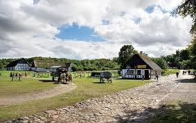
The Hjerl Hede open-air museum literally brings the history of the Danish countryside to life. Walk into the local bakery for a historic piece of bread, ask the chemist for a cone of candies or admire the traditional mill. The rural school and numerous workshops also have a place at Hjerl Hede. This gives a nice picture of Denmark from about 200 years ago.
source: hjerl Hede museet
Hjerlhedevej 14, 7830 Vinderup, Denemarken
56° 29' 3" N 8° 52' 19.1" E
56.4841611 8.8719837
• Head southeast. Go for 146 m.
• Turn right. Go for 107 m.
• Turn right toward Jattrupvej. Go for 90 m.
• Turn slightly right onto Jattrupvej. Go for 197 m.
• Turn left onto Hjerlhedevej. Go for 1.3 km.
• Turn right onto Hailkjærvej. Go for 244 m.
• Turn left onto Hailkjærvej. Go for 1.5 km.
• Turn right onto Sevelvej. Go for 4.9 km.
• Turn left onto Søndergade (189). Go for 1.4 km.
• Take the 1st exit from roundabout onto Struervej (513). Go for 3.1 km.
• Turn sharp right onto Strandvejen. Go for 547 m.
• Turn right onto Handbjerg Marina. Go for 117 m.
• Arrive at Handbjerg Marina. Your destination is on the left.
☍
13,7 km
( 17 min.)
Camperpark Handbjerg Marina, Handbjerg Marina, Vinderup, Denemarken
Handbjerg Marina 1, 7830 Vinderup, Denemarken
56° 28' 32" N 8° 43' 6.3" E
56.4755465 8.7184107
• Head toward Strandvejen on Handbjerg Marina. Go for 117 m.
• Turn left onto Strandvejen. Go for 547 m.
• Turn right onto Struervej (513). Go for 9.0 km.
• Take the 2nd exit from roundabout onto Vester Gimsingvej (509) toward Ringkøbing/Vemb/Ølby. Go for 2.5 km.
• Take the 3rd exit from roundabout onto Lindevej (509). Go for 7.0 km.
• Take the 2nd exit from roundabout onto Lindtorpvej (509). Go for 6.5 km.
• Turn right onto Burvej (509). Go for 6.7 km.
• Turn left onto Søndergade (28). Go for 5.6 km.
• Turn right onto Holstebrovej (16/28) toward Ulfborg/Ringkøbing. Go for 10.9 km.
• Take the 2nd exit from roundabout onto Holstebrovej (16/28) toward Ringkøbing/Skjern. Go for 8.2 km.
• Continue on Holstebrovej (16). Go for 2.3 km.
• Take the 1st exit from roundabout onto Vestre Ringvej (15). Go for 2.5 km.
• Take the 1st exit from roundabout onto Søndervig Landevej (15). Go for 3.4 km.
• Take the 2nd exit from roundabout onto Søndervig Landevej (15). Go for 3.6 km.
• Take the 3rd exit from roundabout onto Holmsland Klitvej (181). Go for 11.3 km.
• Take the 2nd exit from roundabout onto Nørregade (181). Go for 1.9 km.
• Take the 1st exit from roundabout onto Troldbjergvej. Go for 487 m.
• Turn slightly left onto Fabriksvej. Go for 710 m.
• Arrive at Fabriksvej. Your destination is on the right.
☍
83,3 km
(1 hrs. 11 min.)
Day
Via Margriet route
ROUTE 08 NORTH SEA COAST OF JUTLAND km
We pick up in Lemvig:
1. Strandingsmuseum St. George (beachcombing museum)
2. Thorsminde Dodemandsbjergene (sailor's cemetery)
3. Ringkøbing: walk through town
source: Frits Mahn
Autocamper P Stellplatz
Route via Ringkoping
Fabriksvej 31, 6960, Hvide Sande, Denemarken
56° 0' 9" N 8° 7' 13" E
56.0025000 8.1202778
• Head northeast on Fabriksvej. Go for 96 m.
• Turn left onto Industrikaj. Go for 334 m.
• Turn right onto Fabriksvej. Go for 284 m.
• Turn slightly right onto Troldbjergvej. Go for 479 m.
• Take the 1st exit from roundabout onto Søndergade (181). Go for 551 m.
• Pass 2 roundabouts and continue on Søndergade (181). Go for 4.5 km.
• Turn right onto Søholmvej. Go for 319 m.
• Turn slightly left onto Tingodden. Go for 19 m.
• Arrive at Tingodden. Your destination is on the right.
☍
6,6 km
( 9 min.)
Dancamps Holmsland, Tingodden, Hvide Sande, Denemarken
Tingodden 141, 6960 Hvide Sande, Denemarken
55° 57' 44.8" N 8° 8' 28.8" E
55.9624490 8.1413209
• Head south on Tingodden. Go for 60 m.
• Turn right. Go for 53 m.
• Turn right toward Tingodden. Go for 53 m.
• Turn left onto Tingodden. Go for 72 m.
• Continue on Søholmvej. Go for 266 m.
• Turn right onto Sønder Klitvej (181). Go for 18.4 km.
• Turn left onto Vesterlundvej. Go for 1.9 km.
• Turn right onto Værnvej. Go for 3.4 km.
• Turn left onto Vikingevej. Go for 192 m.
• Arrive at Vikingevej. Your destination is on the left.
☍
24,4 km
( 21 min.)
Day
Via Margriet route naar Ribe
1. Nørre Lyngvig Fyr (highest lighthouse)
2. Nymindegab Redningsbådsmuseum (rescue)
Bork Vikingehavn, Vikingevej, Hemmet, Denemarken
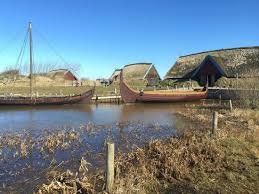
VIKINGS IN BORK VIKINGEHAVN
Bork Vikingehavn is an open-air museum that is all about the Vikings. Actually, a Viking village from about 1000 years ago has been reconstructed here, including long houses with thatched roofs, a harbor for Viking ships and a church to show the rise of Christianity.
In the various buildings of Bork Vikingehavn you will find 'Vikings' who do what they did at the time: baking bread, for example, or making tools. In and around the houses you will also find beautiful examples of wood carvings and other handicrafts, made by the 'Vikings' who work here.
But you can not only watch what the Vikings do - there is also plenty of opportunity to do things yourself. This way you can dress up as a Viking and play all kinds of games - outside and inside happy, because when we were there it was quite rainy weather. There are also some activities that you have to pay for separately, such as baking sandwiches over a campfire or archery. If you want to continue playing at home, you can buy all kinds of Viking-like items in the large shop at the entrance, such as jewelry, mead or a bow and arrow.
We first did the rune treasure hunt - a fun way to get to all corners of the Viking village, from the harbor to the sacrificial site and from the boathouse to the stave church. After we had found all the runes, we still had to solve the puzzle and convert the runes into language that we understand. You can then hand in that solution in a wooden box in the building at the entrance.
Viking lunch
Then it was time for lunch. We ordered two Viking burgers and three pancakes with jam and hot chocolate, because it was so cold that day! The restaurant was outside, but luckily it was clearly indicated that you could also sit in the room with games and fancy dress clothes. There was also a film that gave more information about the life of the Vikings - also in Dutch.
More Vikings? Also read my blog posts about the Vikings in Ribe (also in Denmark), Viking village Foteviken in Sweden and the Viking Ship Museum in Oslo. I also encountered Vikings in Latvia.
Don't forget Fahl Kro:
Tired of Bork Vikingehavn? Do not immediately get back in the car or on the bike! Fahl Kro is still on the other side of the parking lot and you can enter it with your ticket for Bork Vikingehavn for free. We had a weekly ticket from the Ringkøbing-Skjern Museum that allowed us to enter these and even more sights in the region.
Fahl Kro is originally an inn (just think of the Dutch word pub) and you can still eat and drink there. But there is also a small museum, which is partly about Vikings and partly about more recent history of this place. Not very big, but nice enough to step inside.
Source: Radiant writing travel blog Scandinavia, Eastern Europe and the Netherlands Scandinavian livestyle
Vikingevej 7, 6893 Hemmet, Denemarken
55° 50' 13.6" N 8° 15' 57.8" E
55.8371121 8.2660535
• Head toward Værnvej on Vikingevej. Go for 192 m.
• Turn left onto Værnvej. Go for 16 m.
• Continue on Oblingvej. Go for 3.1 km.
• Turn right onto Tarmvej (423). Go for 3.2 km.
• Turn left onto Borkvej. Go for 262 m.
• Turn left onto Teglværksvej. Go for 1.2 km.
• Turn right onto Kvongvej. Go for 1.2 km.
• Take the 3rd exit from roundabout onto Nymindegabvej (181). Go for 12.4 km.
• Turn right onto Nybrovej. Go for 5.9 km.
• Turn right onto Vesterled (431). Go for 3.0 km.
• Take the 3rd exit from roundabout onto Tarphagevej (463). Go for 11.7 km.
• Turn right onto Tarphagevej (447). Go for 2.1 km.
• Pass 2 roundabouts and continue on Tarphagevej (447). Go for 3.5 km.
• Turn right onto Sædding Strandvej. Go for 87 m.
• Turn left. Go for 25 m.
• Arrive at your destination on the right.
☍
47,8 km
( 44 min.)
Margrietroute vervolgen
3. Ravmuseet (amber museum)
4. Fiskeriauktion hall (fish auction hall)
5. Museumfyrskribet 'Horns hev' (fire ship museum)
Mennesket ved havet, Sædding Strandvej, Esbjerg, Denemarken
Sædding Strandvej 1, 6710 Esbjerg, Denemarken
55° 29' 15.9" N 8° 24' 40.2" E
55.4877624 8.4111786
• Head toward Sædding Strandvej. Go for 25 m.
• Turn right onto Sædding Strandvej. Go for 87 m.
• Continue on Hjertingvej (447). Go for 394 m.
• Take the 2nd exit from roundabout onto Hjertingvej (447). Go for 1.7 km.
• Take the 3rd exit from Strandby Plads roundabout onto Strandbygade. Go for 1.0 km.
• Turn right onto Stormgade. Go for 161 m.
• Turn left onto Toldbodvej (E20) toward Kolding/Varde/Ribe/24. Go for 552 m.
• Turn right onto Estrupvej (E20). Go for 955 m.
• Take the 2nd exit from roundabout onto Estrupvej (E20). Go for 1.0 km.
• Take the 2nd exit from roundabout onto Gammelby Ringvej (E20). Go for 1.1 km.
• Take the 2nd exit from roundabout onto Tjæreborgvej (E20). Go for 837 m.
• Keep right onto Tjæreborgvej toward Ribe. Go for 3.5 km.
• Pass 2 roundabouts and continue on Varde Hovedvej (11/24). Go for 21.6 km.
• Turn right onto Farupvej toward Farup. Go for 452 m.
• Turn right onto Farupvej. Go for 71 m.
• Arrive at Farupvej. Your destination is on the right.
☍
33,5 km
( 30 min.)
Ribe Camping, Farupvej 2, 6760 Ribe, Denemarken
Farupvej 2, 6760 Ribe, Denemarken
55° 20' 27.7" N 8° 45' 59.7" E
55.3410173 8.7665948
• Head south on Farupvej. Go for 71 m.
• Turn left onto Farupvej. Go for 452 m.
• Turn right onto Trojelsvej (11/24). Go for 224 m.
• Keep left onto Ringvejen (11/24). Go for 185 m.
• Take the 2nd exit from roundabout onto Plantagevej toward Ribe C. Go for 416 m.
• Take the 1st exit from roundabout onto Nørremarksvej. Go for 183 m.
• Continue on Rosen Alle. Go for 393 m.
• Take the 2nd exit from roundabout onto Dagmarsgade. Go for 439 m.
• Turn right onto V. Støckens Plads. Go for 9 m.
• Continue on Stenbogade. Go for 43 m.
• Continue on Torvet. Go for 86 m.
• Arrive at Torvet. Your destination is on the left.
☍
2,5 km
( 5 min.)
Day
Ribe: wandelen en kijken
Ribe Domkirke
Jacob A. Riis Museum
Ribe Domkirke, Torvet, Ribe, Denemarken
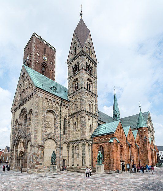
Ribe Cathedral ( Vor Frue Kirke Maria = Domkerk Onze-Lieve-Vrouwe ) is located in the Danish town of Ribe in the south-western part of Jutland.
The Roman Catholic Diocese (Danish: Stift ) of Ribe was founded in 948 AD. The cathedral was built in stone between 1110 and 1134 by Bishop Thure. A wooden church may have been founded by Ansgarius from 860. The last Catholic bishop of Ribe from 1499 was Iver Munk, who died in 1539 and is buried in the Dom.
Since the Reformation in 1536, the Dom is Evangelical Lutheran and belongs to the Folkekirke (the Danish Folk Church). Hans Tausen (foreman of the Danish Reformation) was the bishop of Ribe from 1542 until his death.
Statues in front of the Dom are by Ansgarius (801-864), Hans Tausen (1494-1561) and the poet and bishop Hans Adolph Brorson (1694-1764). The latter two have a grave in the church building, as do the kings Erik II the Unforgettable (died in 1137) and Christopher I (died in 1259).
The current church is largely Romanesque and is considered the best-preserved Romanesque Dom church in Denmark. It is the only church in Denmark to have five naves. The church is 63 meters long and 36 meters wide and today has three towers. The Mariatoren , the Rytterspiret above the Choir [1] and Borgertårnet [2] Borgertårnet dates from 1333 and is 52 meters high and contains 248 steps to the top. The tower was initially 65 meters high and contained a spire, but it collapsed in 1534. In 1595, the tower was renovated, but there was no money for the spire, so that the tower had a flat roof, and was significantly less high.
From 1939 until his death in 1952, Rued Langgaard was the regular player of the organ of the Ribe Cathedral. This instrument was built by the organ builder Frederik Nielsen from Aarhus in 1843 in the still existing, richly decorated greenhouse from 1635, but the entire pipework was renewed in 1973 by Frobenius from Birkerød. Since a later renovation in 1994, the organ has 50 registers.
source: wikipedia
Torvet, 6760 Ribe, Denemarken
55° 19' 41.1" N 8° 45' 40.7" E
55.3280920 8.7613143
• Head east on Torvet. Go for 47 m.
• Turn left onto Grønnegade. Go for 73 m.
• Turn right onto Smalleslippe. Go for 73 m.
• Turn right onto Fiskergade. Go for 79 m.
• Continue on Sortebrødregade. Go for 19 m.
• Arrive at Sortebrødregade. Your destination is on the left.
☍
0,3 km
( )
Jacob A. Riis Museum, Sortebrødregade, Ribe, Denemarken
How the Other Half Lives - Jacob A. Riis Museum is a new permanent museum that will be built in the original home where Jacob A. Riis grew up in Ribe, Denmark.
Jacob A. Riis (1849–1914) is perhaps the most influential Danish expatriate in history. In the center of Jacob A. Riis's hometown, Ribe - the oldest town in Scandinavia - Southwest Jutland Museum (Sydvestjyske Museer) has a block of Renaissance and 19th-century buildings. These buildings are being developed into a museum complex. Between the buildings we find the house where Jacob A. Riis grew up.
In this house, the museum will create an internationally oriented museum, which will show the commitment and importance of the museum on the one hand.The work of Jacob A. Riis and on the other hand will focus on and place the themes in which Riis was so strongly involved. to improve in perspective.
Furthermore, based in one of Riis' other famous books, The Making of an American , the museum will focus on what made Riis the person he was and what is more generally part of shaping one's identity and nationality.
How the other half lives
Jacob A. Riis created social change in his new homeland - the US, and was a famous person and a close personal friend of President Theodore Roosevelt at the time. As a journalist, he is seen as the maker of documentary photography. Through his photos, he showed the misery of which he wrote more vividly than his words could express. He collected his experiences in the book How the Other Half Lives (1890). This book had a major impact on the public understanding of the miserable condition that immigrants in New York especially lived in.
Jacob A. Riis is relevant and relevant today: The Jacob A. Riis settlement plays an important role in Queens. The Museum of the City of New York, which owns Jacob A. Riis' vast collection of glass negatives, showed the exhibition Jacob A. Riis: Revealing New York's Other Half in Fall 2015; Jacob A. Riis: Revealing New York's Other Half (Yale University Press, 2015) is published by Riis expert Bonnie Yochelson; the new Jacob A. Riis exhibition, which opened at the Library of Congress in Washington in April 2016, all testifies to its enduring relevance.
source: jacob a riis museet
Sortebrødregade 1, 6760 Ribe, Denemarken
55° 19' 43.3" N 8° 45' 47.9" E
55.3286859 8.7633194
• Head southeast on Sortebrødregade. Go for 86 m.
• Turn right onto Vægtergade. Go for 65 m.
• Turn left onto Hundegade. Go for 267 m.
• Turn right onto Hundegade. Go for 273 m.
• Continue on Haulundvej. Go for 205 m.
• Take the 2nd exit from roundabout onto Haulundvej. Go for 154 m.
• Take the 1st exit from roundabout onto Haderslevvej (24) toward Esbjerg/Ribe N/Varde/11/Tønder. Go for 318 m.
• Take the 2nd exit from roundabout onto Tøndervej (11) toward Tønder/Rømø. Go for 665 m.
• Take the 2nd exit from roundabout onto Tøndervej (11) toward Tønder/Rømø. Go for 17.2 km.
• Take the 1st exit from roundabout onto Rømøvej (175) toward Rømø. Go for 13.8 km.
• Continue on Vesterhavsvej. Go for 3.6 km.
• Arrive at Vesterhavsvej. Your destination is on the left.
☍
36,5 km
( 32 min.)
Day
First Camp Lakolk Strand Römö
Lakolk Strand 2, 6792, Rømø, Dänemark
55° 8' 43.1" N 8° 29' 40.9" E
55.1453000 8.4947000
• Head toward Lakolk on Vesterhavsvej. Go for 3.6 km.
• Continue on Vesterhavsvej (175). Go for 13.8 km.
• Take the 2nd exit from roundabout onto Ribevej (11) toward Tønder/Skærbæk. Go for 5.7 km.
• Turn left onto Løgumklostervej (401) toward Løgumkloster. Go for 9.8 km.
• Turn right onto Koldingvej (25/401) toward Tønder/Løgumkloster. Go for 1.9 km.
• Take the 3rd exit from roundabout onto Bredebrovej (401/429) toward Løgumkloster. Go for 2.3 km.
• Take the 2nd exit from roundabout onto Omfartsvej (401/429). Go for 5.4 km.
• Continue on Krusåvej (401). Go for 3.3 km.
• Pass 2 roundabouts and continue on Løgumklostervej (401). Go for 15.6 km.
• Take the 3rd exit from roundabout onto Saksborgvej (8/401) toward Tinglev/Kruså. Go for 762 m.
• Turn right onto Flensborglandevej (401) toward Kruså/E45. Go for 12.1 km.
• Take the 2nd exit from roundabout onto Tøndervej (401) toward Kruså/E45. Go for 220 m.
• Turn right and take ramp onto E45 (Sønderjyske Motorvej) toward Flensborg/Grænse. Go for 6.6 km.
• Continue on A7. Go for 156 km.
• Keep left onto A7. Go for 14.7 km.
• Keep right onto A261 (Autobahndreieck Hamburg-Südwest) toward Bremen/Tötensen. Go for 9.0 km.
• Take exit 4 toward Osnabrück/Bremen/Rade onto A1. Go for 69.9 km.
• Take exit 52 toward Achim. Go for 230 m.
• Turn right onto Achimer Straße (L167) toward Hannover/A27/Achim. Go for 292 m.
• Pass 3 roundabouts and continue on Zum Achimer Bahnhof (L167). Go for 4.4 km.
• Take the 2nd exit from roundabout onto Am Schmiedeberg (L158). Go for 1.7 km.
• Turn right onto Brückenstraße (L156). Go for 6.5 km.
• Arrive at Braunschweiger Straße (L203).
☍
343,6 km
(3 hrs. 28 min.)
Day
Day
Braunschweiger Straße, Thedinghausen, Duitsland
Braunschweiger Str., 27321 Thedinghausen, Duitsland
52° 57' 43.7" N 9° 1' 31.6" E
52.9621517 9.0254349
• Head west on Braunschweiger Straße (L203). Go for 296 m.
• Continue on Braunschweiger Straße (L354). Go for 820 m.
• Turn left onto Beppener Bruchweg. Go for 2.0 km.
• Continue on Thedinghauser Straße. Go for 1.7 km.
• Turn right onto Beppener Straße (K8). Go for 1.8 km.
• Take the 2nd exit from roundabout onto Forststraße (K145) toward Martfeld. Go for 1.7 km.
• Continue on K145. Go for 1.9 km.
• Continue on Holzmaase (K145). Go for 1.5 km.
• Turn right onto Verdener Straße (L202). Go for 311 m.
• Turn left onto Kirchstraße (L331) toward Hoya. Go for 9.3 km.
• Turn right onto Auf dem Kuhkamp (L351) toward B6/B215/Gewerbegebiet Ost. Go for 1.5 km.
• Take the 2nd exit from roundabout onto Bücker Straße (L351) toward Lemke/B6/Bücken. Go for 18.0 km.
• Turn left onto Nienburger Straße. Go for 3.5 km.
• Take the 3rd exit from roundabout onto Brückenstraße toward Altstadt-Nord/Fähre Weserfahrten. Go for 928 m.
• Continue on Hafenstraße. Go for 193 m.
• Continue on Marienstraße. Go for 386 m.
• Continue on Buermende. Go for 491 m.
• Turn right onto Hannoversche Straße toward Stadion/Altstadt-Süd. Go for 450 m.
• Continue on Leinstraße. Go for 54 m.
• Arrive at Leinstraße. Your destination is on the right.
☍
46,8 km
( 46 min.)
Day
Nienburg/Weser, Duitsland
31582 Nienburg/Weser, Duitsland
52° 38' 17.1" N 9° 12' 30.3" E
52.6380924 9.2084155
• Head toward Neue Straße on Leinstraße. Go for 54 m.
• Continue on Hannoversche Straße. Go for 98 m.
• Turn right onto Mindener Landstraße. Go for 1.4 km.
• Turn right onto Berliner Ring (B215). Go for 845 m.
• Take the 2nd exit from roundabout onto Berliner Ring (B215) toward Minden/Gewerbegebiet Schäferhof-Süd. Go for 15.8 km.
• Continue on Loccumer Straße (B441) toward Hannover/Münchehagen/Loccum/Minden. Go for 1.7 km.
• Take the 1st exit from roundabout onto B482 toward Minden/Lahde. Go for 39.1 km.
• Take ramp onto A2 toward Dortmund/Osnabrück. Go for 24.6 km.
• Take exit 28 toward Bielefeld-Altenhagen. Go for 372 m.
• Turn right onto Ostwestfalenstraße (L712N). Go for 934 m.
• Take ramp onto Altenhagener Straße (L778) toward Bielefeld-Altenhagen. Go for 406 m.
• Take the 1st exit from roundabout onto Altenhagener Straße (L778). Go for 3.3 km.
• Turn right onto Eckendorfer Straße (L787) toward Bielefeld-Zentrum/Gewerbegebiet Kammerratsheide/Schüco/Gewerbegebiet Werningshof/Gewerbegebiet Schelpmilser Weg. Go for 1.8 km.
• Continue on Eckendorfer Straße (K14). Go for 3.5 km.
• Continue on Ostwestfalendamm (B61) toward Dortmund/A2/Osnabrück/A30/Paderborn/A33/Münster/Gütersloh. Go for 1.1 km.
• Take ramp toward Spenge/BI-Jöllenbeck/SchücoArena. Go for 153 m.
• Turn left onto Jöllenbecker Straße (L783). Go for 250 m.
• Turn left onto Am Güterbahnhof (B61) toward Hannover/A2/Detmold/Herford. Go for 163 m.
• Take the 1st exit from roundabout onto Joseph-Massolle-Straße. Go for 175 m.
• Arrive at Joseph-Massolle-Straße. Your destination is on the left.
☍
95,7 km
(1 hrs. 15 min.)
Bielefeld, Duitsland
52° 1' 48.8" N 8° 31' 56.9" E
52.0302285 8.5324708
• Head southwest on Joseph-Massolle-Straße. Go for 150 m.
• Take the 3rd exit from roundabout onto Am Güterbahnhof (B61). Go for 149 m.
• Turn right onto Jöllenbecker Straße (L783). Go for 218 m.
• Take ramp onto Ostwestfalendamm (B61) toward Dortmund/A2/Osnabrück/A30/Paderborn/A33. Go for 3.7 km.
• Keep left onto Ostwestfalendamm (B61) toward Dortmund/A2/Paderborn/B68/Münster/Gütersloh. Go for 3.3 km.
• Keep left onto B61N toward A33/Paderborn. Go for 675 m.
• Take ramp onto A33. Go for 5.5 km.
• Take exit 21 toward Dortmund onto A2. Go for 138 km.
• Continue on A3. Go for 10.8 km.
• Take exit 14 toward Venlo/Duisburg onto A40. Go for 43.8 km.
• Continue on A67 (Europaweg). Go for 5.6 km.
• Take the exit toward Venray/Nijmegen/Grubbenvorst. Go for 2.8 km.
• Turn left onto Greenportlane (N295). Go for 257 m.
• Turn left toward Industrieterrein Venlo 3200-3400/Industrieterrein Venlo 3900-4000/Fresh Park Gate 2+3/Villa Flora/Innovatoren/Grubbenvorst. Go for 439 m.
• Turn right onto Venrayseweg. Go for 1.6 km.
• Continue on Californischeweg. Go for 1.8 km.
• Continue on Kloosterstraat. Go for 402 m.
• Take the 2nd exit from roundabout onto Kloosterstraat. Go for 401 m.
• Turn right onto Pastoor Zegersstraat. Go for 46 m.
• Arrive at Pastoor Zegersstraat.
☍
219,6 km
(2 hrs. 1 min.)
Day
Grubbenvorst, Nederland
5971 Grubbenvorst, Nederland
51° 25' 11.9" N 6° 8' 41.3" E
51.4199823 6.1448144