The route goes via Reims towards Calais. Then along the coast towards Ostend, De Haan via Bruges and Brussels back to Sankt Ingbert.
Day
St. Ingbert
Saarpfalz-Kreis, Saarland, Deutschland
49° 16' 43.8" N 7° 6' 56.4" E
49.2788378 7.1156707
• Head northwest. Go for 64 m.
• Turn right onto Poststraße. Go for 233 m.
• Turn right onto Maxplatz (L119). Go for 87 m.
• Turn right onto Kaiserstraße (L111). Go for 356 m.
• Turn left onto Blieskasteler Straße (L111) toward A6/Saarbrücken/Mannheim/Blieskastel/Hassel. Go for 766 m.
• Turn right onto Oststraße (L111). Go for 151 m.
• Take the 2nd exit from roundabout onto Oststraße (L111). Go for 763 m.
• Take the 3rd exit from roundabout onto A6 toward Paris/Metz/Saarbrücken. Go for 18.1 km.
• Continue on A320. Go for 13.5 km.
• Continue on E50 (Échangeur de Freyming). Go for 259 m.
• Take the left exit toward Paris/Metz/St Avold/Carling onto A4 (Autoroute de l'Est). Go for 41.6 km.
• Keep left onto A314 toward Metz/Nancy. Go for 3.0 km.
• Keep left onto A314 toward N233/Metz-Centre/Borny. Go for 196 m.
• Continue on Voie Pénétrante Est 1 (D603). Go for 2.7 km.
• Continue on Boulevard de Trèves (D1). Go for 2.0 km.
• Continue on Pont Mixte. Go for 418 m.
• Take ramp toward Nancy. Go for 1.7 km.
• Turn left onto Rue de Paris (N3). Go for 661 m.
• Make a U-Turn onto N3. Go for 49 m.
• Turn right onto Allée de Metz-Plage. Go for 91 m.
• Turn left onto Allée de Metz-Plage. Go for 149 m.
• Arrive at Allée de Metz-Plage. Your destination is on the right.
☍
86,9 km
(1 hrs. 1 min.)
Stationnement de Camping-cars
Allée de Metz Plage, 57000, Metz, France
49° 7' 25" N 6° 10' 8" E
49.1236111 6.1688889
• Head southwest on Allée de Metz-Plage. Go for 149 m.
• Turn right onto Allée de Metz-Plage. Go for 91 m.
• Turn right onto Rue du Pont des Morts (N3). Go for 612 m.
• Turn right onto Rue des Alliés toward Paris/Luxembourg/Strasbourg/Sarrebruck/Z.I. Metz Deux Fontaines. Go for 468 m.
• Take left ramp onto A31 toward Paris/Luxembourg/Pont de Metz. Go for 8.0 km.
• Take the exit toward Verdun/Reims/Paris/Amnéville/Walygator onto A4 (Autoroute de l'Est). Go for 173 km.
• Take the exit toward E46/Charleroi/Charleville-M./Reims-Centre/Cormontreuil onto A34 (Autoroute de l'Est). Go for 3.3 km.
• Continue on A344 (Voie Jean Taittinger). Go for 3.9 km.
• Take exit 23 toward Reims-Cathédrale. Go for 687 m.
• Continue on Boulevard Louis Roederer toward Reims. Go for 11 m.
• Turn right onto Rue de Bir Hakeim toward Reims/Courlancy. Go for 173 m.
• Continue on Rue Caqué. Go for 148 m.
• Turn left onto Rue Buirette. Go for 291 m.
• Take the 1st exit from Place Drouet d'Erlon roundabout onto Rue de l'Étape. Go for 159 m.
• Continue on Rue du Cadran Saint-Pierre. Go for 136 m.
• Turn right onto Cours Jean-Baptiste Langlet. Go for 165 m.
• Turn right onto Cours Jean-Baptiste Langlet. Go for 42 m.
• Turn right onto Rue Carnot. Go for 17 m.
• Turn left onto Rue du Trésor. Go for 85 m.
• Turn left onto Rue Guillaume de Machault. Go for 57 m.
• Arrive at Rue Guillaume de Machault. Your destination is on the right.
☍
191,4 km
(1 hrs. 40 min.)
Day
Cathédrale de Reims
Place du Cardinal Luçon, Reims, Marne, Grand Est, Frankreich
49° 15' 12.8" N 4° 1' 59.9" E
49.2535616 4.0332980
• Head toward Place Myron Herrick on Rue Guillaume de Machault. Go for 57 m.
• Turn right onto Rue du Trésor. Go for 85 m.
• Turn right onto Rue Carnot. Go for 146 m.
• Turn slightly right onto Place Royale. Go for 72 m.
• Turn slightly right onto Rue Cérès. Go for 367 m.
• Take the 6th exit from Place Aristide Briand roundabout onto Boulevard Lundy (N44). Go for 920 m.
• Turn right onto Place de la République. Go for 80 m.
• Continue on Avenue de Laon (N44) toward Laon-Zola/Charles Arnould/Musée de la Reddition. Go for 2.6 km.
• Take the 2nd exit from roundabout onto Avenue de Laon (D944) toward A26(A4)/Laon/La Neuvilette. Go for 1.8 km.
• Take the 1st exit from roundabout onto A26 (Autoroute des Anglais) toward Lille/Laon/Rouen. Go for 81.4 km.
• Take exit 11 toward Gauchy onto D1. Go for 2.4 km.
• Take left ramp onto D1029. Go for 2.7 km.
• Take ramp toward St Quentin-Centre/Bohain en Vermandois/Ham. Go for 209 m.
• Turn right onto Rue Delavenne. Go for 128 m.
• Turn right onto Boulevard Victor Hugo. Go for 511 m.
• Continue on Rue de Tour y Val. Go for 87 m.
• Continue on Rue de Tour y Val. Go for 50 m.
• Turn right onto Rue de Vicq. Go for 185 m.
• Arrive at Rue de Vicq.
☍
93,8 km
( 57 min.)
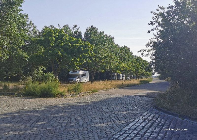
Saint-Quentin
Really great place, nice and easy to pay with card to get through the barrier. Each parking space is very wide.
Rue de Vicq, Saint-Quentin, Aisne, Nordfrankreich, Frankreich
49° 50' 20.2" N 3° 17' 9.4" E
49.8389535 3.2859452
• Head southwest on Rue de Vicq. Go for 23 m.
• Turn right onto Rue Lamartine. Go for 154 m.
• Turn right onto Rue Crozat. Go for 206 m.
• Turn left onto Boulevard Victor Hugo. Go for 581 m.
• Continue on Place Dufour-Denelle. Go for 147 m.
• Continue on Boulevard de Verdun (D1029). Go for 803 m.
• Pass 3 roundabouts and continue on D1029. Go for 1.9 km.
• Take ramp onto A26 (Autoroute des Anglais) toward Calais/Arras/Cambrai. Go for 167 km.
• Take the exit toward Boulogne/Tunnel sous la Manche/Calais-Ouest onto A16 (Autoroute des Estuaires). Go for 3.9 km.
• Take exit 44 toward Calais-St Pierre. Go for 251 m.
• Turn right onto Rue Chevreul (D245) toward Calais-St Pierre. Go for 99 m.
• Take the 2nd exit from roundabout onto Rue Chevreul. Go for 249 m.
• Continue on Rue des Prairies. Go for 709 m.
• Turn left onto Boulevard La Fayette. Go for 480 m.
• Turn right onto Boulevard Jacquard. Go for 463 m.
• Turn slightly right onto Place du Soldat Inconnu. Go for 59 m.
• Turn left onto Place du Soldat Inconnu. Go for 84 m.
• Turn right onto Place du Soldat Inconnu. Go for 33 m.
• Arrive at Place du Soldat Inconnu. Your destination is on the right.
☍
177,0 km
(1 hrs. 40 min.)
Day
Calais
Pas-de-Calais, Nordfrankreich, Frankreich
50° 57' 8.9" N 1° 51' 13.8" E
50.9524769 1.8538446
• Head north on Place du Soldat Inconnu. Go for 79 m.
• Turn right onto Rue Paul Bert. Go for 277 m.
• Continue on Rue Mollien. Go for 500 m.
• Turn left onto Quai de la Loire. Go for 1.0 km.
• Take the 1st exit from roundabout onto Avenue du Commandant Cousteau. Go for 834 m.
• Take the 1st exit from roundabout onto Rue du Nord toward Oye-Plage/Marck/Z.I. des Dunes/Aérodrome de Marck. Go for 432 m.
• Turn left onto Rue des Garennes. Go for 1.7 km.
• Turn right onto Rue des Mouettes. Go for 411 m.
• Turn left onto Route de Gravelines (D119). Go for 1.3 km.
• Continue on Avenue du Général Charles de Gaulle (D119). Go for 3.2 km.
• Continue on Avenue du Général Charles de Gaulle (D119). Go for 5.9 km.
• Continue on Rue du Lac le Tap Cul (D119). Go for 136 m.
• Turn left onto Rue de la Mer (C) toward Les Écardines. Go for 981 m.
• Continue on Route des Dunes. Go for 339 m.
• Turn left. Go for 73 m.
• Arrive at your destination on the right.
☍
17,2 km
( 20 min.)
Camping Des Dunes
Just a few minutes from the fortified town center of Gravelines , a city of labels, and halfway between Dunkirk and Calais , our 4-star campsite with 276 pitches by the sea is a privileged starting point to explore the surroundings. The campsite of the dunes will take you to the place to be discovered in our beautiful region of the North and its Opal Coast .
62215, Oye Plage, France
50° 59' 47.7" N 2° 2' 52.4" E
50.9965900 2.0478800
• Head toward Route des Dunes. Go for 73 m.
• Turn right onto Route des Dunes. Go for 339 m.
• Continue on Rue de la Mer (C). Go for 981 m.
• Turn right onto Rue du Lac le Tap Cul (D119). Go for 136 m.
• Turn left onto Rue de la Mer (D219). Go for 1.1 km.
• Turn right onto Avenue Paul Machy (D940). Go for 6 m.
• Turn left onto Route du Pont d'Oye (D219) toward A16 (Dunkerque)/(Dunkerque)/St Omer. Go for 1.7 km.
• Continue on Rue du Pont d'Oye (D219). Go for 3.7 km.
• Turn left and take ramp onto A16 (Autoroute des Estuaires) toward Gravelines/Dunkerque. Go for 40.3 km.
• Continue on E40. Go for 2.7 km.
• Take exit 1 toward N34/De Panne. Go for 521 m.
• Turn left onto Kromfortstraat (N34) toward E40/Calais/Adinkerke. Go for 442 m.
• Pass 3 roundabouts and continue on Kerkstraat (N34). Go for 2.9 km.
• Turn right onto Kerkstraat (N34). Go for 220 m.
• Turn right onto Veurnestraat (N35). Go for 654 m.
• Turn left onto Keesjesdreef. Go for 113 m.
• Turn right. Go for 274 m.
• Arrive at your destination on the right.
☍
56,1 km
( 44 min.)
Day
(8660) De Panne - 24 Nachtegaalstraat
Large parking lot not far from the center of La Panne, free (follow the Parking Gratis sign). Very quiet night, no noise.nne - 24 Nachtegaalstraat
Nachtegaalstraat 24, De Panne, Veurne, Westflandern, Belgien
51° 5' 50.3" N 2° 35' 51.3" E
51.0973186 2.5975874
• Head toward Brouwersstraat. Go for 41 m.
• Turn right onto Brouwersstraat. Go for 49 m.
• Turn left onto H. Vanelverdinghestraat. Go for 68 m.
• Take the 2nd exit from E. Vileynplein roundabout onto A. Decoussemaekerstraat. Go for 143 m.
• Turn left onto Veurnestraat (N35). Go for 1.1 km.
• Turn left onto Koksijdeweg (N396). Go for 273 m.
• Continue on Robert Vandammestraat (N396). Go for 1.3 km.
• Take the 2nd exit from roundabout onto Robert Vandammestraat (N396) toward Oostduinkerke/Koksijde Dorp. Go for 1.5 km.
• Continue on Houtsaegerlaan (N396). Go for 2.4 km.
• Continue on Dorpstraat (N396). Go for 236 m.
• Keep right onto Dorpstraat (N396) toward Nieuwpoort. Go for 306 m.
• Continue on Nieuwpoortsteenweg (N396). Go for 2.9 km.
• Continue on Nieuwpoortsteenweg (N396). Go for 1.5 km.
• Continue on Canadalaan (N396). Go for 627 m.
• Turn left onto Astridlaan (N39). Go for 527 m.
• Take the 2nd exit from roundabout onto Kaai (N34) toward Middelkerke. Go for 507 m.
• Take the 4th exit from roundabout onto Kustweg (N34) toward Middelkerke. Go for 2.7 km.
• Make a U-Turn at Alfred Madouxstraat onto Kustweg (N34). Go for 38 m.
• Turn right toward Kustweg. Go for 36 m.
• Turn left onto Kustweg. Go for 55 m.
• Arrive at Kustweg.
☍
16,2 km
( 22 min.)
Day
Nieuwpoort
Free parking near the beach. Two wide lanes with enough space for about 20 camper vans. No restriction signs anywhere. Really close to the beach. Shade under the trees from the sun. Cycle path along the main road to Nieuwpoort
Veurne, Westflandern, Belgien
51° 9' 26.8" N 2° 44' 52" E
51.1574545 2.7477785
• Head toward Matrozenlaan on Kustweg. Go for 213 m.
• Turn left onto Matrozenlaan. Go for 308 m.
• Turn sharp left onto Kustweg (N34). Go for 6.4 km.
• Arrive at Koninginnelaan (N34). Your destination is on the left.
☍
6,9 km
( 9 min.)
Day
Middelkerke
Paul de Smet de Naeyerstraat 7, Middelkerke, Ostende, Westflandern, Belgien
51° 11' 16" N 2° 49' 5.9" E
51.1877826 2.8183091
• Head northeast on Koninginnelaan (N34). Go for 6.1 km.
• Turn right onto Northlaan (R31) toward E40/A10/Blankenberge/Gistel/Luchthaven Oostende. Go for 3.1 km.
• Pass 2 roundabouts and continue on Ringlaan (R31). Go for 1.4 km.
• Continue on Dokter Eduard Moreauxlaan (N34). Go for 1.7 km.
• Turn left onto Fortstraat. Go for 223 m.
• Turn right onto Vuurtorenweg. Go for 366 m.
• Arrive at Vuurtorenweg. Your destination is on the right.
☍
12,9 km
( 16 min.)
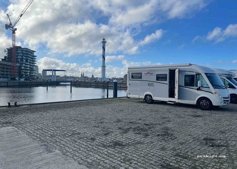
Ostende
Recently adapted camper van pitch. Previously prohibited, now new traffic sign. On the water, near the lighthouse, free ferry to Ostend nearby. 500 m from the beach (above the dunes)
Vuurtorendok-West, Ostende, Ostende, Westflandern, Belgien
51° 14' 16.8" N 2° 55' 59.2" E
51.2379927 2.9331211
• Head east on Vuurtorenweg. Go for 366 m.
• Turn left onto Fortstraat. Go for 202 m.
• Turn left onto Dokter Eduard Moreauxlaan (N34). Go for 1.6 km.
• Turn right toward Bredene-Sas/Bredene-Dorp/Bredene-Duinen/Industriezone Ambachtelijke Zone Noord-Ede. Go for 25 m.
• Turn right onto Zeelaan (N329b). Go for 29 m.
• Turn left onto Driftweg (N317). Go for 308 m.
• Arrive at Driftweg (N317).
☍
2,5 km
( 4 min.)
Day
Bredene
Dunegat, Bredene, Ostende, Westflandern, Belgien
51° 14' 59.8" N 2° 57' 36.8" E
51.2499576 2.9602319
• Head toward Hendrik Consciencelaan on Driftweg (N317). Go for 308 m.
• Turn right onto Zeelaan (N329b). Go for 11 m.
• Turn right onto Koninklijke Baan (N34). Go for 2.1 km.
• Continue on Koninklijke Baan (N34e). Go for 1.4 km.
• Continue on Nieuwe Rijksweg (N34y). Go for 1.4 km.
• Continue on Nieuwe Rijksweg (N34e). Go for 134 m.
• Continue on N34y. Go for 36 m.
• Continue on Nieuwe Rijksweg (N34e). Go for 1.0 km.
• Continue on N34y. Go for 92 m.
• Turn left onto Tramlijn-Oost toward Oostende/Centrum. Go for 68 m.
• Continue on Koninklijk Plein. Go for 35 m.
• Continue on Leopoldlaan. Go for 478 m.
• Turn left onto Koninklijke Baan (N34). Go for 152 m.
• Turn right onto Dürerhelling. Go for 46 m.
• Turn slightly left onto Dürerhelling. Go for 24 m.
• Arrive at Dürerhelling. Your destination is on the right.
☍
7,3 km
( 8 min.)
De Haan
(8420) De Haan - Standard parking with no height restriction and no parking ticket. Right on the beach and a 3-minute walk to a beach bar. Next to a quiet one-way street.
Beautiful location right on the beach. It was quite noisy from the busy road and public toilets were only available in the season when the weather was good, everything was closed or water, there were only garbage cans on the promenade, but the location made up for it. 3 nights with a camper, it was wonderful. On a rainy day we took the Kusttram for a day ticket of €7.50, the stop was a 10 minute walk away.
Zeedijk-De Haan 1, De Haan, Ostende, Westflandern, Belgien
51° 16' 37.4" N 3° 1' 37.1" E
51.2770571 3.0269611
• Head southeast on Dürerhelling. Go for 70 m.
• Turn right onto Koninklijke Baan (N34). Go for 808 m.
• Turn sharp left onto Nieuwe Rijksweg (N34y) toward Blankenberge/Wenduine. Go for 760 m.
• Continue on N34y. Go for 92 m.
• Turn right onto Markt toward E40/Klemskerke. Go for 24 m.
• Turn slightly right onto Stationsstraat. Go for 209 m.
• Turn left onto Grotestraat. Go for 3.8 km.
• Continue on Prins Leopoldstraat. Go for 610 m.
• Turn right onto Brugse Steenweg (N307). Go for 3.5 km.
• Take the 3rd exit from roundabout onto Brugse Steenweg toward Brugge/Meetkerke. Go for 212 m.
• Continue on Oostendse Steenweg (N9). Go for 4.4 km.
• Take the 2nd exit from Oostendse Steenweg roundabout onto Expresweg (E403) toward E40. Go for 1.7 km.
• Take ramp onto Bevrijdingslaan (N351) toward Brugge/Industriezone Waggelwater. Go for 2.1 km.
• Continue on Hoefijzerlaan (R30). Go for 261 m.
• Keep left onto Hoefijzerlaan (R30) toward Maldegem/N9/Oostkamp/N50. Go for 778 m.
• Take the 3rd exit from Unescorotonde roundabout onto Koning Albert I-Laan (R30) toward E40/E403/Haven Zeebrugge/'t Zand. Go for 294 m.
• Keep right toward Centrum 't Zand/'t Zand. Go for 357 m.
• Continue on Zuidzandstraat. Go for 48 m.
• Turn right onto Hoogste van Brugge. Go for 55 m.
• Arrive at Hoogste van Brugge. Your destination is on the left.
☍
20,1 km
( 21 min.)
Day
Brügge
Bruges is the capital of West Flanders in northwestern Belgium. The city is characterized by its canals, cobbled streets and medieval buildings. The port of Zeebrugge is an important center for fishing and European trade. The 14th century Stadhuis (town hall) on Burg Square has an elaborately carved ceiling. On the nearby market square stands a 13th century belfry with a carillon of 47 bells. The 83 m high tower offers a panoramic view
Korte Vuldersstraat 37, Brügge, Brügge, Westflandern, Belgien
51° 12' 17.1" N 3° 13' 8.3" E
51.2047500 3.2189708
• Head toward Westmeers on Hoogste van Brugge. Go for 79 m.
• Turn right onto Westmeers. Go for 6 m.
• Turn left onto Goezeputstraat. Go for 65 m.
• Turn right onto Oostmeers. Go for 54 m.
• Turn right onto Sint-Jan in de Meers. Go for 69 m.
• Turn left onto Westmeers. Go for 400 m.
• Turn left onto Eiland. Go for 38 m.
• Turn right onto Oostmeers. Go for 146 m.
• Turn slightly left onto Oostmeers. Go for 40 m.
• Turn left onto Buiten Begijnenvest (R30). Go for 462 m.
• Turn right onto Bargeweg (R30a). Go for 142 m.
• Turn right. Go for 41 m.
• Turn right. Go for 23 m.
• Turn left. Go for 79 m.
• Arrive at your destination.
☍
1,6 km
( 5 min.)
Brügge
Great location, walking distance to town. Pay for the day or 24 hours including electricity. All waste can be disposed of, fresh drinking water at extra cost. ANPR entrance on the right for camper vans and left for buses. Payment desk in the bus park next to the security office building, payable before departure. Very secure and busy in high season (one in one out). If you don't have a space, you can't get in. The bus park next door has parking while you wait, but at an expensive rate, you can also park via a barrier.
Bargeweg, Brügge, Brügge, Westflandern, Belgien
51° 11' 43" N 3° 13' 33.2" E
51.1952832 3.2258762
• Head northwest. Go for 44 m.
• Turn right. Go for 20 m.
• Turn left toward Bargeweg/R30a. Go for 78 m.
• Turn left onto Bargeweg (R30a). Go for 72 m.
• Turn right onto Buiten Katelijnevest (R30). Go for 445 m.
• Turn right onto Baron Ruzettelaan (N50) toward Oostkamp/Ziekenhuis A.Z. St.-Lucas. Go for 2.0 km.
• Keep left onto Baron Ruzettelaan (N50). Go for 24 m.
• Pass 3 roundabouts and continue on Gruuthuselaan (N50). Go for 4.3 km.
• Take the 3rd exit from Europaplein roundabout onto Kapellestraat (N50g). Go for 1.0 km.
• Turn left and take ramp onto E40 toward Brussel/Gent. Go for 78.1 km.
• Take the exit toward Bergen/Charleroi onto E19. Go for 35.9 km.
• Keep right onto E19 toward Liège/Namur/A54/Charleroi/Wavre/N27/Nivelles-Sud. Go for 2.1 km.
• Continue on E420 (La Carolorégienne) toward Liège/Namur/Charleroi/Gosselies/Aéroport Charleroi. Go for 16.4 km.
• Take the exit toward Aéroport Charleroi/Liège/Namur onto E42. Go for 34.1 km.
• Take the exit toward Luxembourg/Namur onto E411. Go for 31.6 km.
• Take exit 20 toward Philippeville/Dinant onto N97 (Route Charlemagne). Go for 764 m.
• Take ramp toward Dinant/Achêne/Houyet. Go for 221 m.
• Turn right onto Grand-Route de Ciney (N936). Go for 6.3 km.
• Take the 2nd exit from roundabout onto Rue Saint-Jacques (N936). Go for 2.5 km.
• Turn left onto Rue Petite. Go for 67 m.
• Continue on Rue Sous-Les-Roches. Go for 106 m.
• Arrive at Rue Sous-Les-Roches. Your destination is on the left.
☍
216,1 km
(2 hrs. 31 min.)
Day
Citadelle de Dinant
The Citadel of Dinant is a castle built on a high rock on the Meuse, under the Prince-Bishop of Liège, Théoduin. At the beginning of the 19th century, it was extensively expanded as a fortress for defensive and protective purposes. Its individual structures were restored at the end of the 20th century.
Rue Sous-Les-Roches, Dinant, Dinant, Namur, Belgien
50° 15' 42.8" N 4° 54' 46.1" E
50.2618757 4.9128086
• Head toward Rue Adolphe Sax on Rue Sous-Les-Roches. Go for 57 m.
• Turn right onto Rue Adolphe Sax (N92a). Go for 196 m.
• Turn right onto Rue Saint-Jacques (N936). Go for 2.5 km.
• Take the 2nd exit from roundabout onto Rue Saint-Jacques (N936). Go for 6.4 km.
• Turn left and take ramp onto Route Charlemagne (N97) toward Liège/Ciney/E411/Achêne Zone Industrielle. Go for 409 m.
• Take ramp onto E411 toward Luxembourg/Arlon. Go for 21.1 km.
• Take exit 23 toward Wellin/Han-sur-Lesse. Go for 415 m.
• Turn left onto Rue de Dinant (N94) toward Han-sur-Lesse. Go for 988 m.
• Turn right onto Rue Tchèsau (N86) toward Rochefort/Han-sur-Lesse. Go for 5.4 km.
• Turn sharp right onto Rue d'Hamptay. Go for 22 m.
• Arrive at Rue d'Hamptay. Your destination is on the right.
☍
37,5 km
( 28 min.)
Domaine des Grottes de Han
The cave of Han-sur-Lesse is one of the most famous show caves in Europe. It is located in Han-sur-Lesse, which belongs to the municipality of Rochefort on the river Lesse in the Ardennes. The slender stalactite columns in its central part are particularly interesting, and their number is only surpassed by a few stalactite caves. Address: Rue des Grottes 46, 5580 Rochefort, Belgium
Rue Joseph Lamotte 2, Han-sur-Lesse, Dinant, Namur, Belgien
50° 7' 31" N 5° 11' 14.3" E
50.1252740 5.1873135
• Head southwest on Rue d'Hamptay. Go for 63 m.
• Turn right onto Rue des Sarrasins. Go for 194 m.
• Turn left onto Rue Joseph Lamotte (N86). Go for 2.2 km.
• Turn left onto Rue de Resteigne. Go for 1.4 km.
• Continue on Rue des Onais. Go for 715 m.
• Turn left onto Rue des Pairées. Go for 259 m.
• Turn left onto Rue du Gouffre. Go for 293 m.
• Arrive at Rue du Gouffre. Your destination is on the right.
☍
5,2 km
( 7 min.)
Camping Aux Cailloux
Rue du Gouffre 25, 5580, Belvaux (Rochefort), Belgien
50° 6' 33.2" N 5° 11' 52.6" E
50.1092191 5.1979557
• Head southwest on Rue du Gouffre. Go for 293 m.
• Turn right onto Rue des Pairées. Go for 259 m.
• Turn right toward Rue des Onais. Go for 78 m.
• Continue on Rue des Onais. Go for 637 m.
• Continue on Rue de Resteigne. Go for 1.4 km.
• Turn left onto Rue de Wellin (N86). Go for 3.0 km.
• Turn left onto Rue du Sourd d'Ave (N94) toward Wellin/E411. Go for 994 m.
• Turn left and take ramp onto E411 toward Luxembourg/Arlon/Neufchâteau. Go for 86.4 km.
• Continue on A6. Go for 19.9 km.
• Take the exit toward E29/Metz/Saarbrücken/Livange onto A3. Go for 9.4 km.
• Take the exit toward Saarbrücken/Remich/Hellange onto A13. Go for 21.8 km.
• Continue on A8 (Moseltalbrücke). Go for 37.1 km.
• Take exit 9 toward Karlsruhe/Mannheim/Neunkirchen/Dillingen-Süd onto A8. Go for 34.2 km.
• Take exit 21 toward St. Ingbert/Elversberg. Go for 329 m.
• Turn right onto L112 toward Sankt Ingbert/Elversberg. Go for 583 m.
• Take the 2nd exit from roundabout onto Lindenstraße (L112) toward Neunkirchen/St. Ingbert. Go for 4.3 km.
• Turn left onto Josefstaler Straße (L112) toward Sulzbach/Schnappach. Go for 245 m.
• Turn right onto Kohlenstraße (L119) toward B40/Saarbrücken/Dudweiler. Go for 285 m.
• Turn left onto Rickertstraße. Go for 244 m.
• Turn left onto Poststraße. Go for 80 m.
• Turn right. Go for 64 m.
• Arrive at your destination on the right.
☍
221,7 km
(2 hrs. 11 min.)
Day
St. Ingbert
Saarpfalz-Kreis, Saarland, Deutschland
49° 16' 43.8" N 7° 6' 56.4" E
49.2788378 7.1156707