We are going to Spain Feb 6-23 Mar 22 Feb-3-3 We are in Villajoyosa, we had rented a villa there before Corona time but were unable to use it. The villa also has a Camper place. Now Els (mother-in-law) Demelza (daughter) and Néva (granddaughter 2 years) come to the villa for a week and we have a nice week together. Normally we would visit several places with the camper while passing through, now we are going to visit a number of places with rental car) I have looked up and noted everything, places I would like to go and where I am curious about. We have an older dog and we have to take that into account. We do not visit large cities, or at most a lightning visit Diva, our dog, can no longer take long walks, but we can safely leave her alone in the camper for a few hours so that we can go and see a few things. going for a walk We just move the camper at shorter distances, we'll see how it goes. All this is an idea, not a must, just for some orientation If we are going to drive in Febr I will keep track of the journey via Polarsteps, whoever wants can follow us Tips are always welcome I'm already looking forward to it…to be continued
Day
3886 MG Garderen, Nederland
52° 13' 35.3" N 5° 43' 9.3" E
52.2264731 5.7192509
• Head southeast on Oud Milligenseweg. Go for 973 m.
• Turn right onto Apeldoornsestraat (N310/N344). Go for 1.3 km.
• Take the 3rd exit from roundabout onto Provincialeweg (N310). Go for 1.8 km.
• Take the 2nd exit from roundabout onto Provincialeweg (N310). Go for 458 m.
• Turn left and take ramp onto A1 toward Amersfoort. Go for 18.7 km.
• Take exit 14 toward Amersfoort/Utrecht onto A28. Go for 23.4 km.
• Take the exit toward Breda/Rotterdam/Jaarbeurs/A27 onto E30. Go for 2.9 km.
• Continue on A27. Go for 11.2 km.
• Take the exit toward 's-Hertogenbosch onto A2. Go for 24.2 km.
• Take exit 17 toward Zaltbommel/Rossum/Brakel. Go for 595 m.
• Turn right onto N322. Go for 3.4 km.
• Pass 3 roundabouts and continue on Van Heemstraweg (N322). Go for 10.6 km.
• Turn right onto Afsluitdijk. Go for 136 m.
• Turn right onto Schouwendijk. Go for 830 m.
• Turn left onto Loevestein. Go for 3.0 km.
• Turn left onto Schouwendijk. Go for 488 m.
• Arrive at Schouwendijk.
☍
104,0 km
(1 hrs. 13 min.)
Slot Loevestein, Loevestein, Poederoijen, Nederland
Nice place to stand
Loevestein 1, 5307 TG Poederoijen, Nederland
51° 48' 59.1" N 5° 1' 16.9" E
51.8164253 5.0213512
• Head northeast on Schouwendijk. Go for 488 m.
• Turn right onto Loevestein. Go for 3.0 km.
• Turn right onto Schouwendijk. Go for 830 m.
• Turn right onto Afsluitdijk. Go for 169 m.
• Turn right onto Van Heemstraweg (N322). Go for 1.4 km.
• Pass 7 roundabouts and continue on Doornseweg (N322). Go for 8.9 km.
• Take the 1st exit from roundabout onto A27 toward Breda. Go for 26.6 km.
• Take the exit toward Roosendaal/Antwerpen/Industrieterrein Breda 0-7000 onto A58. Go for 6.3 km.
• Take the left exit toward E19/Antwerpen onto A16. Go for 5.9 km.
• Continue on E19. Go for 41.8 km.
• Continue on E19 (Ring Antwerpen 1). Go for 2.5 km.
• Take the exit toward Brussel/Mechelen onto E19 (Antwerpen-Zuid). Go for 35.1 km.
• Take the left exit toward Namen/E411/Luik/Leuven/Luchthaven Zaventem/Brussel onto E40. Go for 4.9 km.
• Continue on R0 toward Ring Brussel/Bergen/Charleroi/Namen/E19/E411. Go for 8.0 km.
• Take ramp onto Route de Mont Saint-Jean (R0) toward Brussel. Go for 21.6 km.
• Take the exit toward Zone Industrielle Ittre/Paris/Mons/Aéroport Charleroi onto E19. Go for 9.6 km.
• Keep right onto E19 toward Liège/Namur/A54/Charleroi/Wavre/N27/Nivelles-Sud. Go for 2.1 km.
• Continue on E420 (La Carolorégienne) toward Liège/Namur/Charleroi/Gosselies/Aéroport Charleroi. Go for 26.7 km.
• Take exit 30 EST toward Châtelet/Couillet/Hôpital I.M.T.R. onto E420 (Pont de Philippeville). Go for 2.9 km.
• Keep left toward Route de Philippeville/E420. Go for 38 m.
• Pass 4 roundabouts and continue on Route de Philippeville (E420). Go for 50.6 km.
• Continue toward D985. Go for 409 m.
• Continue on D985. Go for 2.9 km.
• Take ramp toward Fumay/Revin/Rocroi. Go for 361 m.
• Turn right onto Rue Royale (D877) toward Revin/Rocroi. Go for 1.8 km.
• Arrive at Rue du Tour de Ville (D877).
☍
264,7 km
(2 hrs. 47 min.)
Day
Rue du Tour de ville, Rocroi, Frankrijk
Historic Place
For free
Rue du Tour de ville, 08230 Rocroi, Frankrijk
49° 55' 20.8" N 4° 31' 24.2" E
49.9224580 4.5233777
• Head toward Rue des Sorbiers on Rue du Tour de Ville (D877). Go for 319 m.
• Take the 2nd exit from roundabout onto Rue de la Croix de Fer. Go for 1.8 km.
• Continue on Croix de Fer. Go for 127 m.
• Turn left toward A304/Reims/Charleville-M./Bruxelles/Charleroi. Go for 221 m.
• Take the 2nd exit from roundabout toward E420/Reims/Charleville-M. Go for 481 m.
• Continue on A304. Go for 28.0 km.
• Continue on A34. Go for 33.2 km.
• Keep left onto N51 toward Reims/Rethel/L'Étoile. Go for 31.6 km.
• Keep left onto A34. Go for 12.5 km.
• Keep left onto Avenue Nicéphore Niépce (N244) toward Paris/Châlons en Ch. Go for 241 m.
• Keep left onto Avenue Nicéphore Niépce (N244) toward A34/E50/E46/Paris/Lyon/Metz/Nancy/Châlons-en-Ch. Go for 102 m.
• Take ramp onto A34 (Autoroute de l'Est). Go for 2.1 km.
• Take the left exit toward E17/E46/E50/Paris/Lille/Reims-Sud onto A4 (Contournement Sud de Reims). Go for 5.8 km.
• Take exit 23 toward Épernay. Go for 1.4 km.
• Take the 2nd exit from roundabout onto D951 toward Épernay/Champfleury/Villers-Allerand. Go for 268 m.
• Take the 1st exit from roundabout onto Route Nationale (D951) toward Épernay/Villers-Allerand. Go for 11.3 km.
• Take the 1st exit from roundabout onto Lieu-dit Maison du Vigneron (D71). Go for 166 m.
• Continue on D71. Go for 115 m.
• Turn left onto Rue de la Briqueterie. Go for 93 m.
• Arrive at Rue de la Briqueterie. Your destination is on the right.
☍
129,7 km
(1 hrs. 22 min.)
Rue de la Briqueterie, Saint-Imoges, Frankrijk
Great free overnight stay for transit.
All amenities available, water and electricity paid
Rue de la Briqueterie, 51160 Saint-Imoges, Frankrijk
49° 6' 24.1" N 3° 58' 43.9" E
49.1066949 3.9788733
• Head north on Rue de la Briqueterie. Go for 93 m.
• Turn left onto Rue d'Épernay (D71). Go for 427 m.
• Turn left onto Rue d'Hauvillers (D71). Go for 9 m.
• Continue on Rue d'Hautvillers (D71). Go for 677 m.
• Continue on Lieu-dit La Farandole (D71). Go for 98 m.
• Continue on D71. Go for 2.6 km.
• Turn right onto D386. Go for 4.7 km.
• Take the 2nd exit from roundabout onto D386. Go for 7.1 km.
• Take the 3rd exit from roundabout onto D980 toward Château-Thierry/Ville en Tardenois/Dormans/Chambrecy. Go for 12.0 km.
• Take ramp onto A4 (Autoroute de l'Est) toward Château-Th. Go for 76.6 km.
• Take exit 15 toward Melun/Provins/Coutevroult/Fontenay-Trésigny onto D1036. Go for 4.6 km.
• Take the 1st exit from roundabout onto D1036. Go for 1.2 km.
• Take the 2nd exit from roundabout onto D1036 toward Provins/Melun/Gretz-Tournan/Fontenay-Trésigny/Neufmoutiers en B. Go for 3.5 km.
• Take the 3rd exit from roundabout onto D1036 toward Melun. Go for 8.5 km.
• Pass 3 roundabouts and continue on D1036. Go for 17.5 km.
• Take the 2nd exit from roundabout onto A5 toward Paris. Go for 7.4 km.
• Continue on A5 A. Go for 8.3 km.
• Take the exit toward Paris Par A6/Nantes/Corbeil-Essonnes/Évry/Tigery/St Pierre du Perray onto N104 (La Francilienne). Go for 5.3 km.
• Keep left onto La Francilienne (N104) toward A6-A13/Bordeaux/A10/Nantes/Évry/Corbeil-Esses-Centre/Centre Hospitalier. Go for 4.2 km.
• Keep right onto N104 toward A13/A10/Bordeaux/Nantes/Versailles/Bondoufle. Go for 3.1 km.
• Take left ramp onto N104 toward A13/Rouen/A10/Bordeaux/Nantes/Versailles/Bondoufle. Go for 1.5 km.
• Take left ramp onto La Francilienne (N104). Go for 17.5 km.
• Take ramp onto A10 (L'Aquitaine) toward Nantes/A11/Chartres/Bordeaux/Orléans. Go for 96.3 km.
• Take the exit toward A20/Toulouse/Clermont-Fd/Vierzon onto A71. Go for 58.7 km.
• Take exit 4 toward Romorantin-L./Salbris/La Ferté Imbault/Romorantin-Lay. Go for 1.3 km.
• Take the 1st exit from roundabout onto D724 toward La Ferté Imbault. Go for 3.9 km.
• Take the 2nd exit from roundabout onto Lieu-dit La Petite Buffière (D724). Go for 2.9 km.
• Turn left onto Rue du Onze Novembre (D147). Go for 952 m.
• Continue on D147. Go for 273 m.
• Continue on Lieu-dit Le Plessis (D147). Go for 115 m.
• Continue on D147. Go for 231 m.
• Continue on Lieu-dit Le Petit Plessis (D147). Go for 99 m.
• Continue on D147. Go for 1.7 km.
• Turn left onto D147. Go for 423 m.
• Continue on Lieu-dit La Bedinière (D147). Go for 12 m.
• Continue on D147. Go for 3.2 km.
• Continue on Douy (D147). Go for 2.0 km.
• Continue on D147. Go for 142 m.
• Turn right onto D76. Go for 659 m.
• Continue on Lieu-dit Fonciel (D76). Go for 68 m.
• Continue on D76. Go for 181 m.
• Continue on Rue des Berthets (D76). Go for 2.1 km.
• Turn left onto D123. Go for 494 m.
• Continue on Lieu-dit Le Marais (D123). Go for 58 m.
• Continue on D123. Go for 74 m.
• Continue on Route de Sologne (D123). Go for 4.2 km.
• Continue on Rue de Gaudet (D123). Go for 410 m.
• Continue on D123. Go for 14 m.
• Continue on Rue de Gaudet (D123). Go for 122 m.
• Turn right onto Rue Pierre Loyau (D976). Go for 2.8 km.
• Arrive at Route de Mennetou (D976). Your destination is on the left.
☍
370,4 km
(3 hrs. 53 min.)
Day
Route de Mennetou sur Cher, Langon, Frankrijk
The intention was to stand at the Camperplaats near Julien-sur-Cher
Pretty nice location but kind of taken over by gypsies/travellers
We stood there for a while, on the other side and Walter went to see how or what
A fire was lit and there was a lot of rubbish
It didn't give us a good feeling and that's why we drove to Langon
A parking lot, but fine for an overnight stay
Later saw another Camperplace in Villefranche sur Cher, it might have been better
Rte de Mennetou sur Cher, 41320 Langon-sur-Cher, Frankrijk
47° 16' 53.9" N 1° 49' 56" E
47.2816252 1.8322243
• Head northwest on Route de Mennetou (D976).
• Turn right onto Lotissement de la Justice. Go for 143 m.
• Turn left onto Route de Mennetou (D976). Go for 3.2 km.
• Turn right onto D37 toward Maray/St Loup-sur Cher. Go for 251 m.
• Turn left onto Route de Maray (D37). Go for 316 m.
• Continue on D37. Go for 1.3 km.
• Continue on Lieu-dit Le Pont de Maray (D37). Go for 631 m.
• Continue on D37. Go for 325 m.
• Continue on Rue de la République (D37). Go for 324 m.
• Continue on D37. Go for 484 m.
• Turn right onto D37. Go for 479 m.
• Turn left onto Lieu-dit Les Gouards (D51). Go for 81 m.
• Turn right onto D37. Go for 3.8 km.
• Continue on Lieu-dit Grandmont (D37). Go for 72 m.
• Continue on D37. Go for 73 m.
• Continue on Lieu-dit Grandmont (D164). Go for 107 m.
• Continue on D164. Go for 749 m.
• Continue on Route de Maray (D164). Go for 1.1 km.
• Turn left onto Route d'Anjouin (D108). Go for 15 m.
• Turn right onto Rue du Haut Bourg (D19). Go for 1.2 km.
• Continue on D19. Go for 1.1 km.
• Continue on Lieu-dit Locatures des Bois (D19). Go for 63 m.
• Continue on D19. Go for 4.1 km.
• Continue on Rue Basse. Go for 133 m.
• Continue on Rue Ludovic Martinet (D922). Go for 55 m.
• Turn right onto Place du Marché. Go for 61 m.
• Turn left onto Rue Félix Pyat. Go for 153 m.
• Turn right onto Place de l'Église (D922). Go for 7.9 km.
• Continue on Avenue de Paris (D920). Go for 50 m.
• Continue on Grande Rue (D136). Go for 436 m.
• Continue on Place de la République (D920). Go for 2.8 km.
• Take ramp onto A20 (L'Occitane) toward Châteauroux. Go for 142 km.
• Take exit 28 toward Angoulême/Périgueux/Couzeix/Rilhac Rancon/Aéroport Bellegarde. Go for 382 m.
• Take the 2nd exit from roundabout onto Rocade Nord-Ouest (N520) toward Poitiers/Angoulême/Saint-Junien/Couzeix/Oradour S/Glane/Aéroport Bellegarde/Périgueux/Z.I.N Centre Routier. Go for 915 m.
• Take the 2nd exit from roundabout onto Rocade Nord-Ouest (N520) toward Poitiers/Angoulême/Périgueux/St Junien/Oradour S/G./Aéroport Bellegarde/Couzeix. Go for 13.3 km.
• Take the 1st exit from roundabout onto N141 toward Angoulême/St Junien/Oradour S/Glane. Go for 5.2 km.
• Take ramp toward St Gence/Veyrac/Oradour S/ Glane. Go for 621 m.
• Turn right onto Route de Limoges à Confolens (D9) toward Veyrac/Oradour S/Glane. Go for 1.9 km.
• Take the 3rd exit from roundabout onto Route d'Oradour-sur-Glane (D9). Go for 4.7 km.
• Continue on D3. Go for 910 m.
• Take the 2nd exit from roundabout onto Avenue du 10 Juin 1944 (D3). Go for 234 m.
• Arrive at Avenue du 10 Juin 1944 (D3). Your destination is on the right.
☍
201,8 km
(2 hrs. 11 min.)
Day
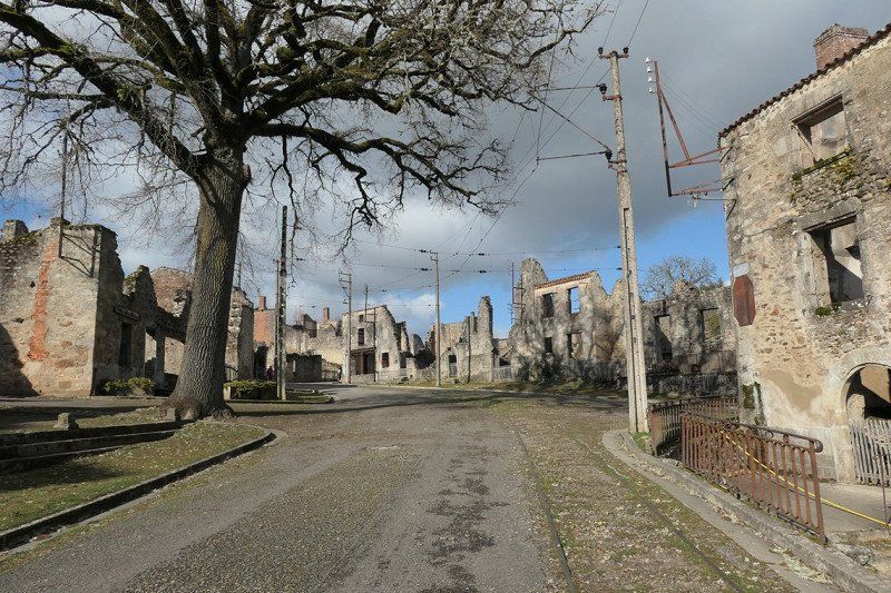
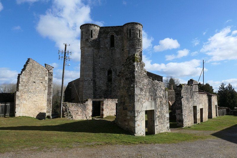
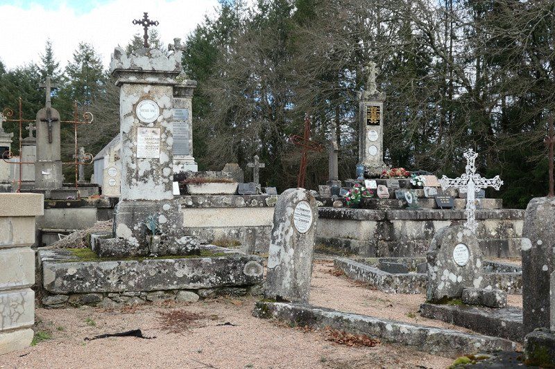
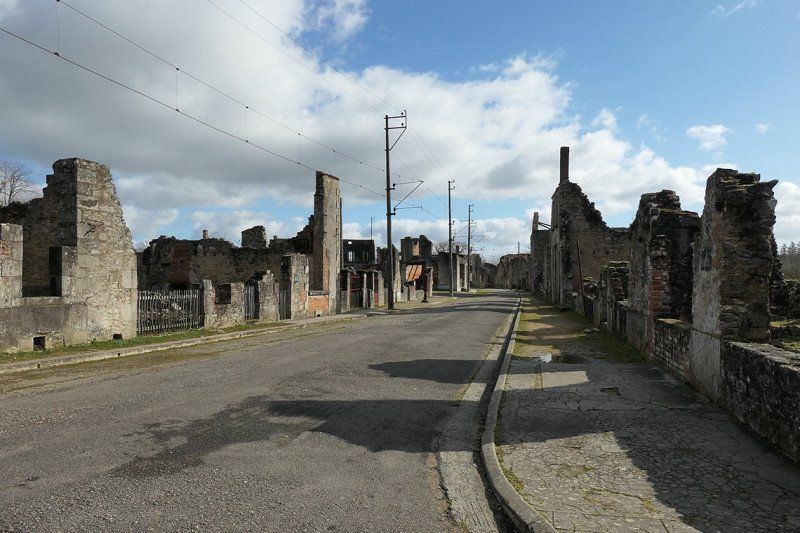
Oradour-sur-Glane, Frankrijk
Aire de camping-car Oradour-sur-Glane
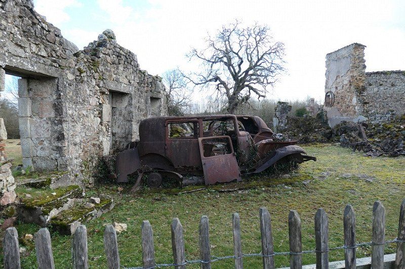
Destroyed village, well worth a visit
If you have trouble walking You can park the camper near the entrance of the information center
What an impression this village of madness has made on us
June 10, 1944 642 people were murdered here in 3 hours and the entire village was destroyed
Only 6 villagers managed to escape
The men were herded into granaries and shot by the German 2nd Waffen SS Panzer Division, the women and children were driven into the imposing church, where there was a box with explosives. Those who fled the church and came out were shot dead
It was a retaliation
It is incomprehensible
Have now started the book "A girl from Oradour" written by Michele Claire Lucas
87520 Bloedbad van Oradour-sur-Glane, Frankrijk
45° 55' 51.9" N 1° 1' 57.9" E
45.9310789 1.0327460
• Head toward Rue de la Renaissance on Avenue du 10 Juin 1944 (D3). Go for 202 m.
• Take the 2nd exit from roundabout onto D3. Go for 936 m.
• Continue on D9. Go for 4.6 km.
• Take the 2nd exit from roundabout onto Route de Limoges (D9). Go for 2.1 km.
• Turn right and take ramp onto N141 toward Limoges/Verneuil S/Vienne/Aéroport Bellegarde. Go for 5.8 km.
• Keep left onto D941 toward N141/Limoges. Go for 6.4 km.
• Turn right onto Boulevard du Mas Bouyol (N520). Go for 82 m.
• Turn right onto Boulevard du Mas Bouyol (N520). Go for 1.1 km.
• Take the 2nd exit from roundabout onto Boulevard de Vanteaux (N520) toward Périgueux/Clermont-Fd/Toulouse/C.H.R.U. Dupuytren/Z.I. Magre-Romanet/Le Roussillon. Go for 523 m.
• Continue on Boulevard de Vanteaux (N520) toward Périgueux/Clermont-Fd/Toulouse/Centre Ville/C.H.R.U. Dupuytren/Z.I. Magré-Romanet. Go for 315 m.
• Take the 2nd exit from roundabout onto Boulevard de Vanteaux (N520) toward Périgueux/Clermont-Fd/Toulouse/Centre Ville/Z.I. Magré-Romanet. Go for 1.0 km.
• Keep right onto Boulevard Bel Air (N520) toward Périgueux/Clermont-Fd/Toulouse/Centre-Ville/Z.I. Magré-Romanet. Go for 606 m.
• Keep left onto Boulevard Bel Air (N520) toward Condat/Nexon/St Yrieix. Go for 96 m.
• Continue on Boulevard du 21 Août 1944. Go for 222 m.
• Continue on Boulevard Robert Maloubier. Go for 578 m.
• Take the 3rd exit from roundabout onto Boulevard du 21 Août 1944 toward Toulouse/St Yrieix. Go for 658 m.
• Take the 2nd exit from roundabout onto Boulevard Geneviève de Gaulle-Anthonioz toward Toulouse/St Yrieix. Go for 1.3 km.
• Take the 3rd exit from roundabout onto Boulevard de la Valoine toward Toulouse/St Yrieix. Go for 1.1 km.
• Take the 1st exit from roundabout onto Rue de Toulouse (D704) toward A20/(Toulouse)/St Yrieix la Perche. Go for 697 m.
• Turn left toward Toulouse/Tulle/Brive/P.A. Bosseuil-le Vigen. Go for 42 m.
• Take ramp onto A20 (L'Occitane). Go for 208 km.
• Take exit 59 toward St Antonin-Noble-Val/Caussade/Cahors/Montpezat de Quercy. Go for 1.6 km.
• Take the 3rd exit from roundabout onto D820 toward Cahors. Go for 1.6 km.
• Take the 2nd exit from roundabout onto D820 toward Cahors. Go for 1.3 km.
• Take the 1st exit from roundabout onto Avenue de Molières (D22) toward Caussade. Go for 485 m.
• Turn right onto Avenue du Docteur Olive (D117). Go for 147 m.
• Turn left onto Place du Général de Gaulle (D17). Go for 265 m.
• Continue on Avenue Maréchal de Lattre de Tassigny (D17). Go for 724 m.
• Continue on Route des Pigeonniers (D17). Go for 360 m.
• Take the 1st exit from roundabout onto D926 E. Go for 293 m.
• Take the 3rd exit from roundabout onto Route du Causse (D926) toward Rodez/Septfonds. Go for 841 m.
• Pass 2 roundabouts and continue on Avenue Marcel Lacassagne (D926). Go for 5.8 km.
• Turn right onto Route de Caylus (D5) toward St Antonin Noble-Val/Laguépie/Gorges de l'Aveyron. Go for 7.3 km.
• Continue on D958. Go for 3.6 km.
• Turn right onto Boulevard de la Condamine (D19). Go for 546 m.
• Turn left onto D19. Go for 7.5 km.
• Continue on D91. Go for 9.2 km.
• Turn right onto Route de la Canade (D33) toward Tonnac/Frausseilles/Donnazac. Go for 2.6 km.
• Continue on D33. Go for 573 m.
• Continue on Route des Puits (D33). Go for 164 m.
• Continue on D33. Go for 444 m.
• Continue on Route des Vignes (D33). Go for 1.8 km.
• Continue on D33. Go for 11 m.
• Continue on Route des Vignes (D33). Go for 2.8 km.
• Turn left onto D922. Go for 2.5 km.
• Turn right onto Route de Virac (D107). Go for 1.7 km.
• Continue on D107. Go for 1.8 km.
• Turn right onto D600. Go for 16.2 km.
• Take the 1st exit from roundabout onto Route de Cordes (D600). Go for 547 m.
• Take the 1st exit from roundabout onto Rue Capitaine Julia. Go for 296 m.
• Take the 1st exit from Rue Capitaine Julia roundabout onto Rue Capitaine Julia. Go for 669 m.
• Turn right onto Chemin de Pratgraussals. Go for 35 m.
• Turn slightly right onto Chemin de Pratgraussals. Go for 305 m.
• Turn left onto Chemin de Pratgraussals. Go for 381 m.
• Arrive at Chemin de Pratgraussals. Your destination is on the right.
☍
310,1 km
(3 hrs. 28 min.)
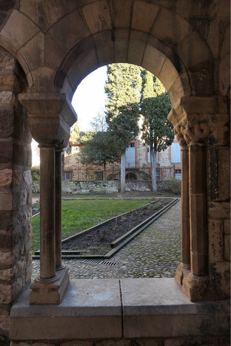
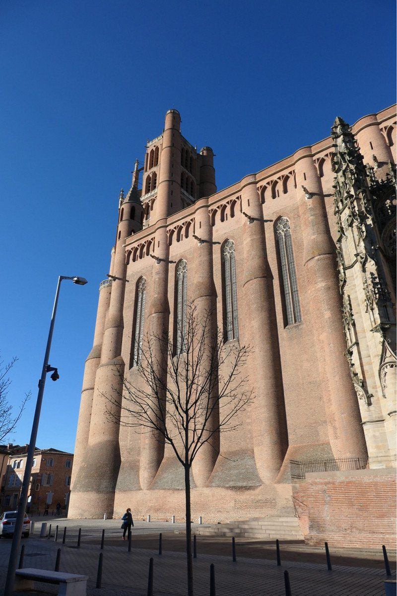
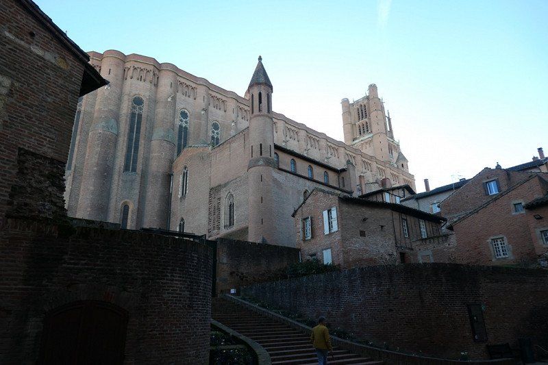
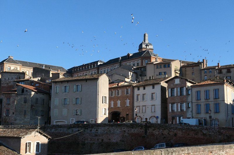
Day
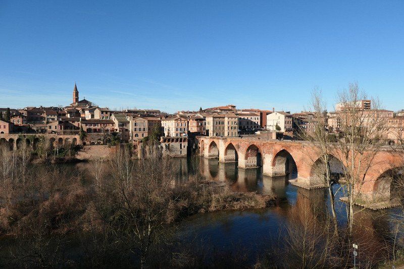
Chemin de Pratgraussals, Albi, Frankrijk
Aire de Camping-Car Pratgraussals
Visit Albi is really worth it
Beautiful Camperplace, you can walk to the city
€0.00 and amenities also free
There is a beautiful skating rink, fun for youth and it doesn't inconvenience you
There is a train track, train comes by now and then, don't you suffer from it either
Chem. de Pratgraussals, 81000 Albi, Frankrijk
43° 55' 52.2" N 2° 8' 12.4" E
43.9311706 2.1367815
• Head toward Rue de Lamothe on Chemin de Pratgraussals. Go for 185 m.
• Turn left onto Rue de Lamothe. Go for 443 m.
• Turn slightly right onto Rue Rinaldi. Go for 153 m.
• Turn slightly left onto Rue Porta. Go for 177 m.
• Turn right onto Rue de la Visitation. Go for 102 m.
• Turn right onto Boulevard de Strasbourg (D600). Go for 953 m.
• Take the 2nd exit from Place Jean Jaurès roundabout onto Boulevard Édouard Andrieu. Go for 318 m.
• Take the 3rd exit from Place du 8 Mai 1945 roundabout onto Boulevard du Lude. Go for 584 m.
• Take the 2nd exit from Rond-Point de la Rachoune roundabout onto Boulevard du Lude toward Toulouse/Montauban/Castres. Go for 259 m.
• Take ramp onto N88 toward Toulouse/Montauban/Castres. Go for 8.1 km.
• Keep left onto A68 toward Toulouse/Montauban/Gaillac. Go for 61.4 km.
• Take the left exit toward Tarbes/Lourdes/Montpellier/Foix/Toulouse-Centre/Gramont onto A61 (Autoroute des Deux Mers). Go for 148 km.
• Take the exit toward Sigean/Perpignan/Barcelone onto A9 (La Languedocienne). Go for 87.0 km.
• Continue on AP-7 (Autopista de la Mediterrània). Go for 20.3 km.
• Take exit 3 toward Figueres N./Roses/Figueres/Girona/Barcelona/Olot/Ripoll. Go for 390 m.
• Take the 3rd exit from roundabout onto N-2 toward Figueres/Girona/Barcelona. Go for 5.4 km.
• Take ramp onto Carretera de Roses (C-260) toward Roses. Go for 1.6 km.
• Pass 2 roundabouts and continue on C-260. Go for 3.4 km.
• Take the 3rd exit from roundabout onto C-260 toward Castelló d'Empúries/Roses/Cadaqués. Go for 1.9 km.
• Take the 4th exit from roundabout onto C-260 toward Roses/Cadaqués. Go for 1.8 km.
• Take the 4th exit from roundabout onto C-260 toward Empuriabrava/Roses/Cadaqués. Go for 2.0 km.
• Pass 4 roundabouts and continue on Carretera de Besalú a Roses (C-260). Go for 4.9 km.
• Take the 3rd exit from roundabout onto Carretera de Cadaqués (GI-614) toward Cadaqués. Go for 1.1 km.
• Take the 2nd exit from roundabout onto Carretera de Cadaqués (GI-614) toward Cadaqués. Go for 10.7 km.
• Take the 1st exit from roundabout onto GI-614 toward Cadaqués. Go for 4.2 km.
• Continue on Carretera a Roses (GI-614). Go for 365 m.
• Take the 3rd exit from roundabout onto Carretera de Port Lligat toward Figueres/Roses/Portlligat. Go for 1.2 km.
• Continue on Carrer Roger de Llúria. Go for 93 m.
• Turn left onto Carrer des Maltret. Go for 42 m.
• Turn right onto Carrer de Castelló d'Empúries toward Port Lligat-Casa s'Dali/Ermita de St. Baldiri/Es Caials-Mas Caials/Càmping Cadaqués/Hotel Calina/Hotel Port Lligat. Go for 42 m.
• Continue on Carretera de Port Lligat. Go for 199 m.
• Turn left onto Avinguda de Salvador Dalí toward Port Lligat. Go for 101 m.
• Turn slightly right onto Avinguda de Salvador Dalí. Go for 239 m.
• Turn right onto Avinguda de Salvador Dalí. Go for 150 m.
• Arrive at Avinguda de Salvador Dalí. Your destination is on the right.
☍
367,9 km
(3 hrs. 42 min.)
Day
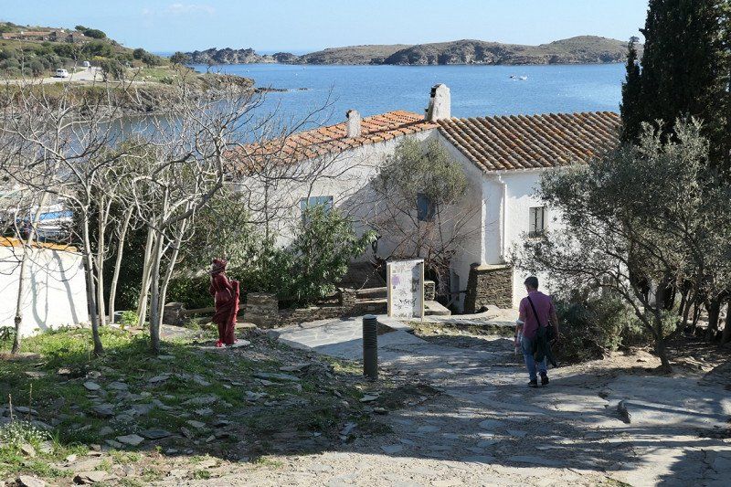
Avinguda Paratge S'Alqueria, Cadaqués, Spanje
€10 In low season you are here for free
Casa museo Salvador Dali in Port Lligat, here is also the Camperplace.
You look fantastic
Walking to Center ville Cadequés is tough but doable and definitely worth it
Picturesque place
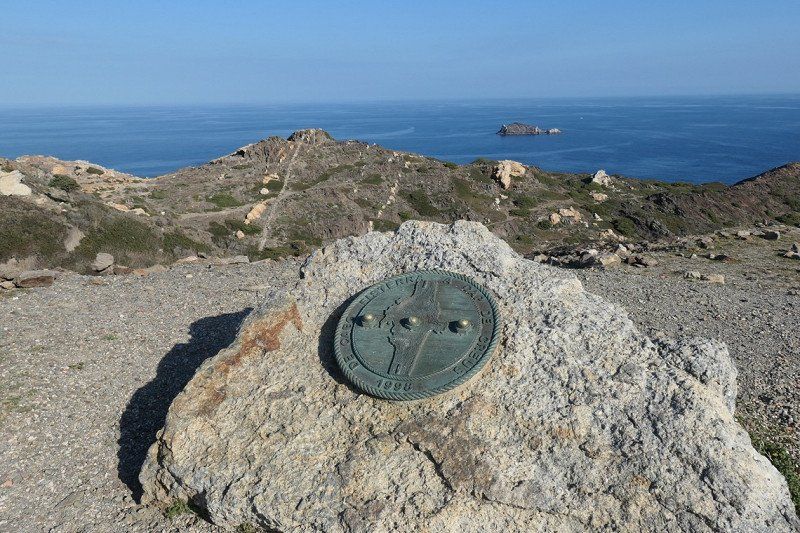
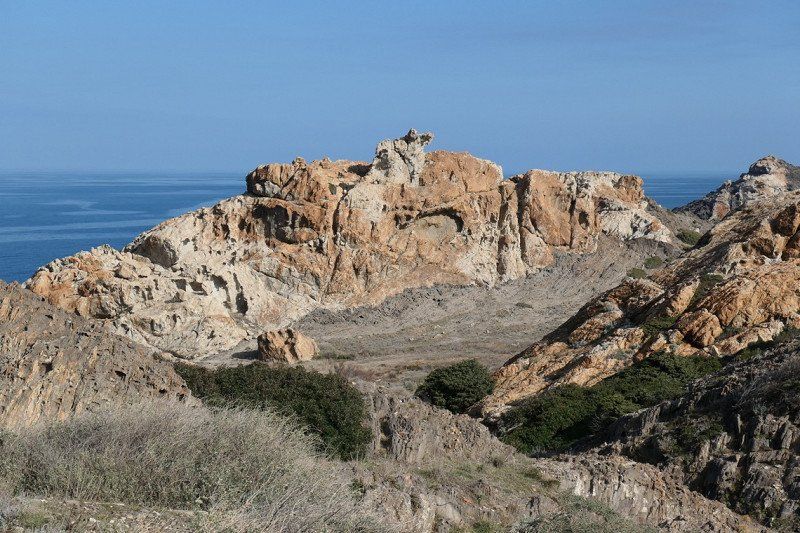
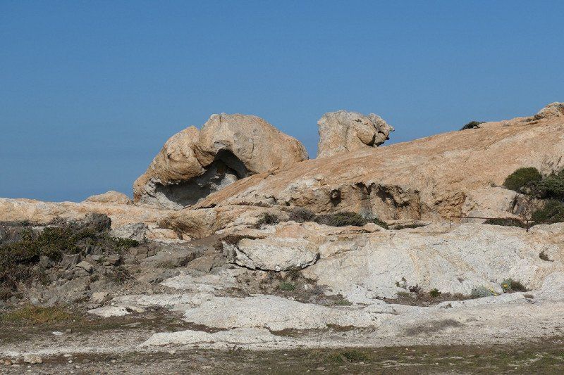
Cap Creus is also worth a visit, beautiful rock formations
Avinguda Paratge S'Alqueria, Cadaqués, Girona, Spanje
42° 17' 37.7" N 3° 17' 10.6" E
42.2938100 3.2862654
• Head east on Avinguda de Salvador Dalí. Go for 86 m.
• Continue on Avinguda Paratge s'Alqueria. Go for 352 m.
• Turn left onto Carrer d'Emília Trèmols. Go for 438 m.
• Turn left onto Camí del Cap de Creus. Go for 787 m.
• Turn slightly left onto Camí del Cap de Creus. Go for 250 m.
• Turn right onto Carrer sa Guarda. Go for 84 m.
• Turn right onto Carretera de Port Lligat toward Centre Vila. Go for 1.1 km.
• Take the 1st exit from roundabout onto Carretera a Roses (GI-614) toward Roses/Figueres. Go for 377 m.
• Continue on GI-614. Go for 4.2 km.
• Take the 2nd exit from roundabout onto Carretera de Roses a Cadaqués (GI-614) toward Roses/Figueres. Go for 10.7 km.
• Take the 3rd exit from roundabout onto Carretera de Roses a Vilajuïga (GI-610) toward Centre Ciutat Roses. Go for 903 m.
• Take the 2nd exit from roundabout onto Carretera Estació de Vilajuïga (GI-610) toward Centre Vila/La Ciutadella/Centre Ciutat. Go for 324 m.
• Take the 2nd exit from roundabout onto Carrer Bernat Metge. Go for 131 m.
• Turn right onto Carrer Joanot Martorell. Go for 159 m.
• Continue on Carrer Calderón de la Barca. Go for 443 m.
• Turn right onto Carrer del Port de Reig. Go for 108 m.
• Arrive at Carrer del Port de Reig.
☍
20,4 km
( 32 min.)
Day
Day
Carrer del Port de Reig, Roses, Spanje
Caravanning Park Roses
€14
Park as far to the right as possible upon entering, due to noise pollution
Visiting Roses and Santa Margarida
Trying to go to Figueres on e-scooter for Dalimuseum and Castell de San Ferran
Carrer del Port de Reig, 17480 Roses, Girona, Spanje
42° 15' 57.2" N 3° 9' 21.8" E
42.2658882 3.1560659
• Head toward Avinguda Clot dels Franquets sud on Carrer del Port de Reig. Go for 352 m.
• Take the 3rd exit from roundabout onto Carretera de Besalú a Roses (C-260) toward AP-7/Figueres/Girona/Sta. Margarida. Go for 690 m.
• Take the 3rd exit from roundabout onto Carretera de Besalú a Roses (C-260) toward AP-7/Empuriabrava/Figueres/Girona. Go for 1.1 km.
• Pass 4 roundabouts and continue on C-260. Go for 5.7 km.
• Take the 4th exit from roundabout onto Carretera de Sant Miquel de Fluvià (GIV-6216) toward St. Pere Pescador/l'Escala. Go for 295 m.
• Continue on GIV-6216. Go for 6.5 km.
• Continue on Carretera de Sant Miquel de Fluvià (GIV-6216). Go for 278 m.
• Take the 2nd exit from roundabout onto Carrer Sant Sebastià (GIV-6216) toward Centre Ciutat. Go for 242 m.
• Continue on Carretera d'Armentera a Viladamat (GIV-6303). Go for 197 m.
• Turn left onto Carrer Carme (GIV-6303) toward l'Armentera/l'Escala/Oficina de Turisme. Go for 105 m.
• Turn right onto Pont de Sant Pere Pescador (GIV-6303). Go for 198 m.
• Continue on GIV-6303. Go for 21 m.
• Take the 2nd exit from roundabout toward l'Escala. Go for 432 m.
• Continue on Carrer Empordà. Go for 77 m.
• Take the 2nd exit from roundabout onto Carrer d'Empori. Go for 377 m.
• Continue on Avinguda d'Empúries. Go for 557 m.
• Continue on Carretera San Martín de Empúries. Go for 4.2 km.
• Continue on Càmping La Ballena Alegre. Go for 140 m.
• Continue on Carretera San Martín de Empúries. Go for 1.1 km.
• Continue on Ronda de Sant Pere Pescador. Go for 418 m.
• Take the 1st exit from roundabout onto GIP-6307 toward l'Escala. Go for 1.0 km.
• Turn left onto Camí de les Muralles. Go for 774 m.
• Continue on Carrer de les Muralles. Go for 174 m.
• Turn left onto Carretera del Museu (GIP-6304). Go for 571 m.
• Turn right. Go for 83 m.
• Arrive at your destination on the right.
☍
25,7 km
( 31 min.)
Day
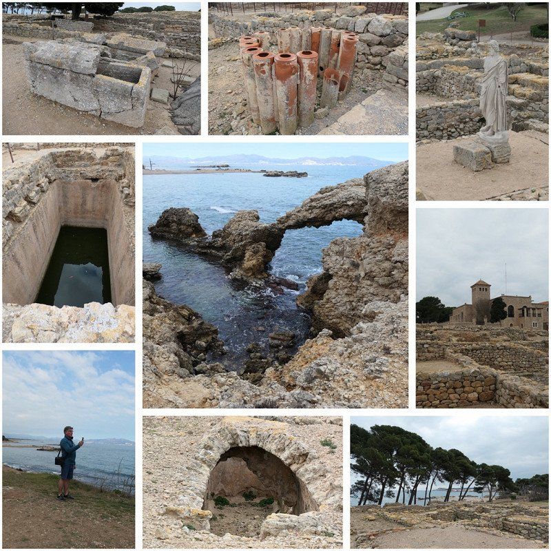
Ruïnes d'Empúries, C/ Puig i Cadafalch, L'Escala, Spanje
Between the marina town and the town of Sant Marti d'Empuries are large Greco-Roman excavations with ample parking options.
You can also stay here out of season
C/ Puig i Cadafalch, s/n, 17130 L'Escala, Girona, Spanje
42° 8' 6.5" N 3° 7' 11.2" E
42.1351440 3.1197660
• Head toward Carretera del Museu. Go for 83 m.
• Turn left onto Carretera del Museu (GIP-6304). Go for 1.0 km.
• Turn left onto GI-630. Go for 80 m.
• Turn right onto Avinguda Francesc Macià. Go for 147 m.
• Take the 3rd exit from roundabout onto Carretera de Vilademat a l'Escala (GI-623) toward Torroella de Montgrí/l'Escala/Bellcaire d'E./Torroella de M. Go for 1.1 km.
• Keep right toward Bellcaire d'E./La Bisbal d'Empordà/l'Escala. Go for 175 m.
• Continue on Carretera Escala a Viladamat toward Puig-Sec/Riells de Dalt/Port-la Clota/Montgó/Torroella de Montgrí. Go for 287 m.
• Continue on Carretera Bellcaire d'Empúries (GI-632). Go for 220 m.
• Take the 2nd exit from roundabout onto GI-632 toward La Bisbal d'Empordà. Go for 3.7 km.
• Continue on Carretera de l'Escala (GI-632). Go for 1.0 km.
• Continue on GI-632. Go for 45 m.
• Take the 2nd exit from roundabout onto GI-632. Go for 2.4 km.
• Continue toward C-31. Go for 35 m.
• Take the 2nd exit from roundabout onto C-31. Go for 1.3 km.
• Continue on Carretera de Torroella de Montgrí a Verges (C-31). Go for 39 m.
• Continue on C-31. Go for 203 m.
• Take the 2nd exit from roundabout onto Carretera de Torroella de Montgrí a Verges (C-31) toward Torroella de Montgrí/Torroella M. Go for 216 m.
• Continue on C-31. Go for 22 m.
• Continue on Carretera de Torroella de Montgrí a Verges (C-31). Go for 94 m.
• Continue on C-31. Go for 72 m.
• Continue on Carretera de Torroella de Montgrí a Verges (C-31). Go for 18 m.
• Continue on C-31. Go for 592 m.
• Take the 2nd exit from roundabout onto Carretera de Sant Jordi (C-31) toward Torroella de Montgrí. Go for 806 m.
• Take the 2nd exit from roundabout onto Avinguda Lluís Companys (C-31) toward l'Estartit/Palafrugell. Go for 504 m.
• Take the 3rd exit from Plaça Lledoner roundabout onto Passeig de Catalunya (C-31) toward CAP Hospital/Gualta/Pals/Palafrull/Palamós/Urb. Mas Pinell/Centre Ciutat. Go for 471 m.
• Take the 2nd exit from roundabout onto Carretera de Palafrugell a Torroella de Montgrí (C-31) toward Palafrugell/La Bisbal d'Empordà/Girona. Go for 340 m.
• Continue on C-31. Go for 233 m.
• Take the 2nd exit from roundabout onto C-31 toward Pals/Palafrugell/Palamós. Go for 7.0 km.
• Continue on Carretera de Palafrugell a Torroella de Montgrí (C-31). Go for 440 m.
• Take the 1st exit from roundabout onto Carretera Pals a Torroella (GI-650a) toward Pals Centre Ciutat/Centre Ciutat Pals. Go for 326 m.
• Turn right onto Carrer de la Font. Go for 27 m.
• Turn left onto Carrer del Camí Fondo. Go for 166 m.
• Turn left onto Carrer d'Enric Fort. Go for 23 m.
• Arrive at Carrer d'Enric Fort. Your destination is on the left.
☍
23,3 km
( 25 min.)
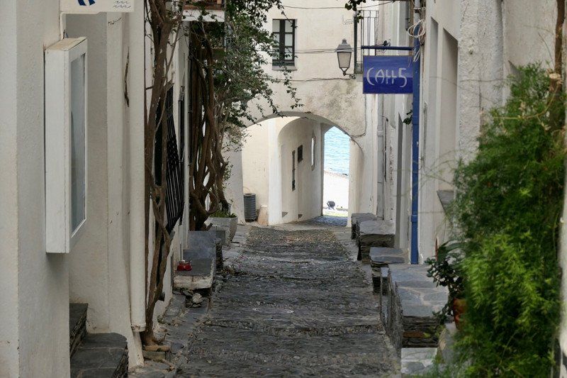
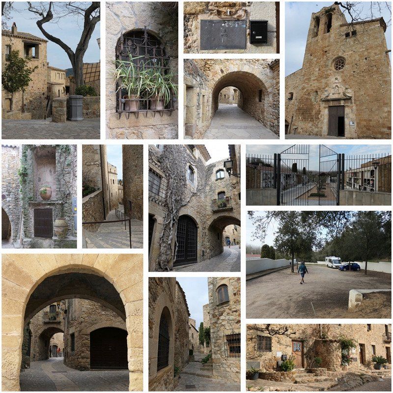
Pals, Spanje
Pals is known as one of the most charming villages to visit during your holiday on the Costa Brava. It is located on top of a hill and was built around a fortress. To this day, it has preserved its medieval appearance so well that visiting Pals feels like a journey back in time.
The old center is very well cared for and the inhabitants cherish their local traditions and gastronomy. Every year there are even several gastronomic and cultural events. The natural environment is breathtaking, with a beach, dunes, swamps and rice fields. They are all part of a natural park. The list below offers tips to enjoy the best of Pals.
It is pleasant to stroll in the historic heart of Pals. It is so beautiful and authentic that you can easily imagine yourself in another time. The cobbled streets, the centuries-old facades, the surprising details and architectural gems, such as picturesque arches and doorways, breathe the history of the village, while flowers add color to the historical splendor.
Pals is so excellently preserved thanks to a local doctor who, after the village had fallen into neglect, took the lead in its restoration. The old part was subsequently declared a Historic Site in 1973.
Pals was first mentioned in the 9th century, but several signs indicate that it was inhabited before that. The name comes from the Latin 'Palus', which means 'marshland'. It is therefore surrounded by lakes and swamps.
Some historical highlights
- The round Romanesque tower Torre de las Horas ('The Tower of Hours') from the 11th and 13th centuries stands out at the end of the winding main road. The tower is all that remains of the former castle, which was completely destroyed during the Catalan Civil War in the 15th century. It was then converted into a Gothic-style bell tower, hence the name. A total of four towers are still standing, connected by the defensive walls.
- At the highest point is the Mirador Josep Pla lookout, named after the writer of the nearby charming seaside village of Palafrugell, whom Pals liked to describe in his work: "Pals is good for not one but a hundred visits." From this point you have a wide view over the Medes Islands, the Montgrí massif, Canigó and the Sierra de l'Albera.
- The Church of Sant Pere has been around for over 1000 years. Some of the stones used to build it come from the former castle of Pals.
Over the centuries, the church has evolved into a mix of different architectural styles: it has a Romanesque base, which also includes Gothic and Baroque elements, plus an 18th century bell tower.
- The fortified Museu-Casa de Cultura Ca La Pruna dates from the 15th and 16th centuries. It offers a permanent display of Catalan wines and cavas, plus a replica of an 18th-century pharmacy.
This building also houses the Museum of Archaeology, with objects once found on an English warship that sank during the siege of Roses during the War of Independence (1808) - now a pleasant seaside resort.
During your walk you will also come across nice art galleries and shops. You can pick up colorful Catalan pottery for a good price.
You can relax with a drink on one of the terraces in the attractive historic setting of Pals - for example on the main square at the town hall, Plaça Major.
If you are going to eat something, be sure to order the traditional rice dish Arròs de Pals a la cassola in one of the local restaurants. After all, Pals has been growing rice for nearly five centuries. There is even a special rice campaign ('Pals and his rice cuisine') in early spring.
17256 Pals, Girona, Spanje
41° 58' 15" N 3° 8' 49.9" E
41.9708460 3.1472021
• Head south on Carrer d'Enric Fort. Go for 110 m.
• Turn right onto Carrer d'Enric Fort. Go for 187 m.
• Turn left onto Carrer de Pere Coll. Go for 39 m.
• Turn right onto Carrer de l'Enginyer Algarra (GI-650a). Go for 443 m.
• Take the 1st exit from roundabout onto GI-652 toward GL-652/Torrent/La Bisbal d'E./Palamós. Go for 768 m.
• Continue on Carretera de Pals (GI-652). Go for 1.8 km.
• Take the 2nd exit from roundabout onto Carretera de Torrent (GI-652). Go for 166 m.
• Continue on GI-652. Go for 671 m.
• Take the 2nd exit from roundabout onto C-66 toward Palafrugell/Mont-Ras/Palamós. Go for 1.8 km.
• Take the 2nd exit from roundabout onto Carretera de Girona a Palamós (C-66) toward Palafrugell/Palamós/Barcelona. Go for 610 m.
• Keep right onto C-31 (Carretera de Girona a Palamós) toward Palafrugell/Palamós/Barcelona. Go for 7.2 km.
• Take exit 326 toward La Fosca/St. Joan de Palamós/Palamós/Hospital. Go for 519 m.
• Take the 4th exit from roundabout toward AP-7/Palamós/St. Joan P./La Fosca. Go for 201 m.
• Keep left toward Palafrugell/La Fosca/Sant Joan de Palamós/Palamós. Go for 469 m.
• Take the 1st exit from roundabout onto Carrer Àngel Guimerà toward Palamós/St. Joan de Palamós. Go for 510 m.
• Take the 1st exit from roundabout onto Carrer d'Arnau sa Bruguera toward Vila-Romà/Eis Angels. Go for 145 m.
• Turn right onto Carrer de Joan Rovira i Bastons. Go for 208 m.
• Arrive at Carrer de Joan Rovira i Bastons. Your destination is on the right.
☍
15,8 km
( 15 min.)
17230 Palamós, Spanje
Caravanning Palamos
€15
Nice walking/cycling
Beautiful view
17230 Palamós, Gerona, Spanje
41° 51' 43.8" N 3° 7' 58.1" E
41.8621690 3.1328011
• Head toward Carrer de Rafael Savalls on Carrer de Joan Rovira i Bastons. Go for 29 m.
• Turn slightly right onto Carrer de Rafael Savalls. Go for 143 m.
• Continue on Carrer Àngel Guimerà. Go for 266 m.
• Take the 4th exit from roundabout onto Carrer Àngel Guimerà. Go for 580 m.
• Take the 3rd exit from roundabout onto C-31 toward Palafrugell. Go for 7.4 km.
• Take the 2nd exit from roundabout onto Carretera de Girona a Palamós (C-66) toward Girona. Go for 629 m.
• Pass 4 roundabouts and continue on C-66. Go for 7.7 km.
• Take the 1st exit from roundabout onto GI-644 toward Peratallada/Ullastret/Torroella de Montgrí. Go for 2.3 km.
• Take the 3rd exit from roundabout onto GI-644 toward Ullastret. Go for 2.5 km.
• Continue on Carretera de Vulpellac a Serra de Daró (GI-644). Go for 266 m.
• Take the 2nd exit from roundabout onto Carretera de Vulpellac a Serra de Daró (GI-644) toward Serra de Daró/Torroella de Montgrí/Poblat Ibèric. Go for 333 m.
• Continue on GI-644. Go for 2.3 km.
• Take the 2nd exit from roundabout onto GI-644 toward Girona/Serra de Daró. Go for 226 m.
• Continue on Carretera a Ullastret (GI-644). Go for 349 m.
• Turn left toward AP-7/Girona. Go for 45 m.
• Take the 3rd exit from roundabout onto Carretera a Ullastret (GI-643) toward AP-7/Girona/Banyoles. Go for 111 m.
• Continue on Carrer de Torroella (GI-643). Go for 20 m.
• Continue on GI-643. Go for 2.9 km.
• Continue on Carretera de Torroella de Montgrí a Parlavà (GI-643). Go for 299 m.
• Take the 1st exit from roundabout onto Carrer de la Salvetat (C-252) toward Figueres. Go for 4.5 km.
• Pass 2 roundabouts and continue on C-31. Go for 24.9 km.
• Take the 2nd exit from roundabout onto N-2A toward AP-7/Girona/Barcelona. Go for 1.3 km.
• Take the 2nd exit from roundabout onto N-2A toward Girona. Go for 555 m.
• Take the 1st exit from roundabout toward Barcelona/Girona. Go for 889 m.
• Take ramp onto AP-7 (Autopista de la Mediterrània) toward França/Francia. Go for 29.2 km.
• Continue on A9 (La Catalane). Go for 86.1 km.
• Take the exit toward Toulouse/E80/Carcassonne onto A61 (Autoroute des Deux Mers). Go for 21.9 km.
• Take exit 25 toward Lézignan-Corbières/Ferrals-les-Corbières/Fabrezan/Durban-Corbières. Go for 720 m.
• Take the 3rd exit from roundabout onto D611 toward Fabrezan/Ferrals-les-Corbières. Go for 3.1 km.
• Take the 2nd exit from roundabout onto D611. Go for 2.4 km.
• Turn right onto Avenue de la Promenade (D212). Go for 122 m.
• Continue on Avenue de Lagrasse (D212). Go for 672 m.
• Continue on D212. Go for 2.6 km.
• Turn right onto D114. Go for 968 m.
• Continue on Avenue de la Promenade (D114). Go for 135 m.
• Continue on D114. Go for 46 m.
• Continue on Avenue de la Promenade (D114). Go for 178 m.
• Continue on Chemin de Lagrasse (D114). Go for 965 m.
• Continue on D114. Go for 161 m.
• Continue on Lieu-dit La Tuilerie (D114). Go for 147 m.
• Continue on D114. Go for 2.9 km.
• Continue on Lieu-dit Cabriéral de Pechlat (D114). Go for 44 m.
• Continue on D114. Go for 1.9 km.
• Arrive at D114.
☍
214,7 km
(2 hrs. 14 min.)
4HQX+W8 Val-de-Dagne, Frankrijk
43° 8' 23.1" N 2° 35' 53.8" E
43.1397537 2.5982666
• Head east on D114. Go for 1.9 km.
• Continue on Lieu-dit Cabriéral de Pechlat (D114). Go for 44 m.
• Continue on D114. Go for 2.9 km.
• Continue on Lieu-dit La Tuilerie (D114). Go for 147 m.
• Continue on D114. Go for 161 m.
• Continue on Chemin de Lagrasse (D114). Go for 965 m.
• Continue on Avenue de la Promenade (D114). Go for 178 m.
• Continue on D114. Go for 46 m.
• Continue on Avenue de la Promenade (D114). Go for 135 m.
• Continue on D114. Go for 968 m.
• Turn left onto D212. Go for 2.6 km.
• Continue on Avenue de Lagrasse (D212). Go for 672 m.
• Continue on Avenue de la Promenade (D212). Go for 2.5 km.
• Take the 2nd exit from roundabout onto D611. Go for 3.1 km.
• Take the 1st exit from roundabout onto A61 (Autoroute des Deux Mers) toward Narbonne/Montpellier. Go for 21.0 km.
• Take the exit toward Sigean/Perpignan/Barcelone onto A9 (La Languedocienne). Go for 87.0 km.
• Continue on AP-7 (Autopista de la Mediterrània). Go for 136 km.
• Keep right onto AP-7 (Autopista de la Mediterrània) toward Lleida/E-90/AP-2/Tarragona/Sabadell/C-58/Túnels de Vallvidrera/E-9/Manresa/C-16/Polígon Industrial de Zona Franca/Fira. Go for 11.5 km.
• Take exit 20 toward Sabadell/Manresa/Barcelona onto C-58. Go for 13.2 km.
• Continue on C-16. Go for 1.9 km.
• Take exit 23 toward Terrasa oest/Barcelona/A-2/Lleida onto B-40 (Quart Cinturó). Go for 10.2 km.
• Take the exit toward Lleida onto A-2 (Autovia Lleida-Barcelona). Go for 6.5 km.
• Take exit 576A toward Collbató. Go for 429 m.
• Continue on Carretera de Monistrol (B-112). Go for 146 m.
• Take the 2nd exit from roundabout onto B-112 toward La Salut/Coves del Salnitre/Monistrol de Montserrat. Go for 322 m.
• Turn left onto Carrer Nou toward Centre Ciutat Nucli Històric. Go for 38 m.
• Take the 1st exit from roundabout onto Carrer del Mil.lenari. Go for 174 m.
• Turn right onto Passeig de Cervantes. Go for 271 m.
• Turn left onto Carrer de Joan Vacarisas. Go for 103 m.
• Turn right onto Carrer la Muntanya. Go for 143 m.
• Turn left onto Carrer de Pau Bertran. Go for 431 m.
• Arrive at your destination.
☍
305,5 km
(2 hrs. 53 min.)
Day
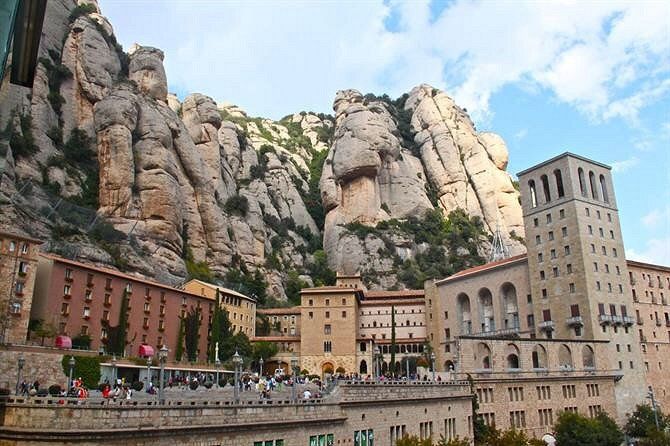
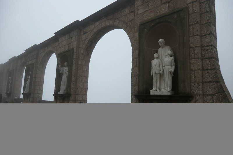
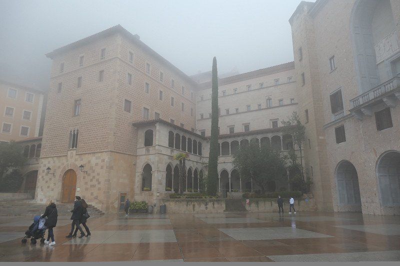
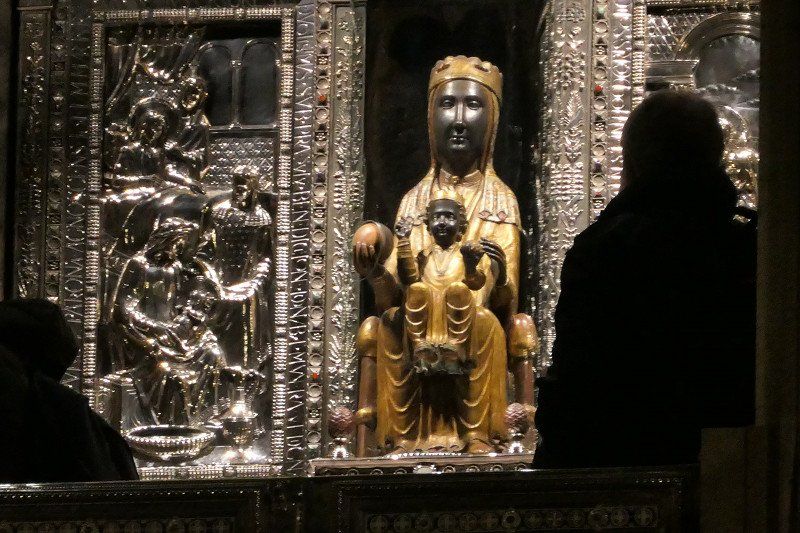
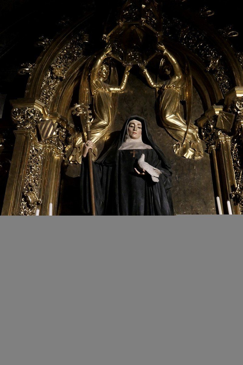
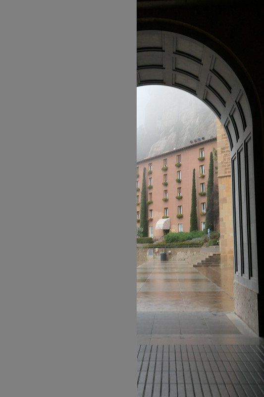
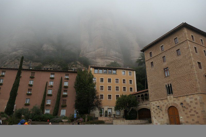
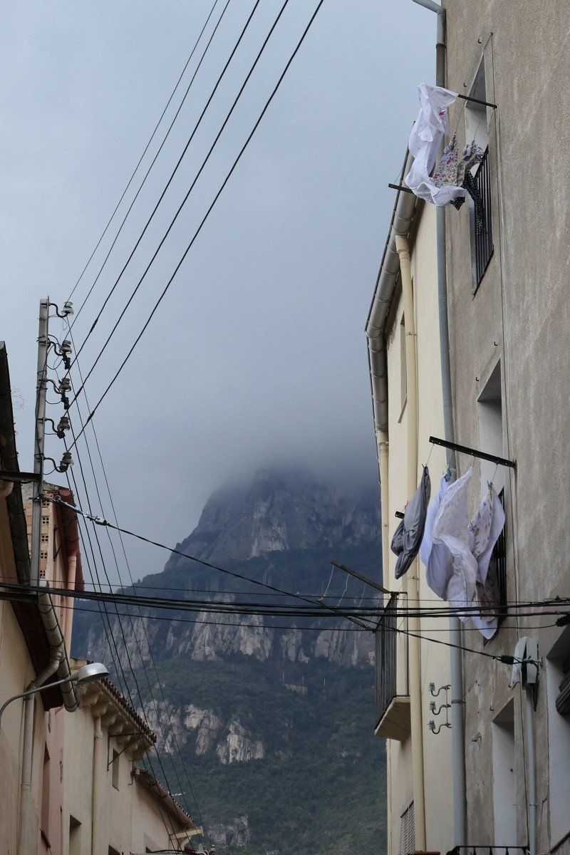
Montserrat, 08691, Spanje
very beautiful, unfortunately we were not able to see it with clear weather, but it is also beautiful in the fog
Montserrat, 08691, Barcelona, Spanje
41° 35' 44.8" N 1° 49' 47.3" E
41.5957765 1.8298142
• Head toward Carrer de Pau Bertran. Go for 40 m.
• Turn left toward Carrer dels Graus. Go for 39 m.
• Turn right onto Carrer dels Graus. Go for 218 m.
• Turn right onto Carrer Drecera. Go for 97 m.
• Turn left onto Carrer de Pau Bertran. Go for 119 m.
• Turn right onto Carrer la Muntanya. Go for 140 m.
• Turn left onto Carrer de Colón. Go for 103 m.
• Turn left onto Passeig de Cervantes. Go for 46 m.
• Turn right onto Carrer Amadeu Vives. Go for 89 m.
• Turn right onto Carrer Amadeu Vives. Go for 264 m.
• Turn left toward B-112. Go for 110 m.
• Turn sharp right onto B-112. Go for 447 m.
• Take the 2nd exit from roundabout onto Carretera de Monistrol (B-112) toward Polígono Industrial de les Ginesteres/A-2. Go for 395 m.
• Continue toward Martorell/Barcelona. Go for 42 m.
• Take the 2nd exit from roundabout onto A-2 (Autovia Lleida-Barcelona) toward Martorell/Barcelona. Go for 8.8 km.
• Take exit 585 toward Martorell/E-15/AP-7/Tarragona onto N-2A. Go for 2.2 km.
• Keep right onto N-2A toward E-15/E-90/Lleida/AP-7/Tarragona/Barcelona/Girona/Capellades/B-224. Go for 2.7 km.
• Take ramp onto AP-7 (Autopista de la Mediterrània) toward Lleida/Tarragona. Go for 12.4 km.
• Take exit 27 toward St. Sadurní d'Anoia/Subirats. Go for 1.0 km.
• Take the 2nd exit from roundabout onto BP-2427 toward Polígon Industrial de Subirats/St. Sadurní d'Anoia/Gelida. Go for 375 m.
• Take the 1st exit from roundabout onto BP-2427 toward St. Sadurní de l'Heura/Gelida/St. Sadurní A./Igualada. Go for 1.3 km.
• Continue on BV-2244. Go for 363 m.
• Take the 2nd exit from roundabout onto Carretera de Sant Sadurní d'Anoia (BV-2244). Go for 1.4 km.
• Take the 3rd exit from roundabout onto C-532 toward St. Sadurní d'Anoia Sub/Vilafranca del Penedès/C-533/St. Sadurní A. sud/Vilafranca P. Go for 1.5 km.
• Take the 2nd exit from roundabout onto C-243a toward St. Pau d'Ordal. Go for 2.1 km.
• Turn left toward Subirats/Lavern/St. Pau d'Ordal/St. Cugat Sesgarrigues. Go for 47 m.
• Continue on Carretera de Sant Pau d'Ordal (BV-2429). Go for 1.2 km.
• Continue on BV-2429. Go for 398 m.
• Turn left. Go for 309 m.
• Turn left. Go for 146 m.
• Arrive at your destination on the left.
☍
38,5 km
( 32 min.)
Cava Guilera, Lavern, Spanje
Camí de Ca l´Artigas s/n, 08739 Lavern, Barcelona, Spanje
41° 23' 55.5" N 1° 46' 13.6" E
41.3987550 1.7704398
• Head northwest. Go for 268 m.
• Turn right toward BV-2429. Go for 309 m.
• Turn left onto BV-2429. Go for 345 m.
• Take the 1st exit from roundabout onto BV-2429. Go for 561 m.
• Continue on Carrer Can Almirall (BV-2429). Go for 209 m.
• Continue on BV-2429. Go for 1.0 km.
• Continue on Carretera de Sant Cugat (BV-2429). Go for 175 m.
• Continue on BV-2429. Go for 1.6 km.
• Take the 2nd exit from roundabout onto BV-2429 toward St. Cugat S./Barcelona/Tarragona. Go for 402 m.
• Continue on Carretera de Sant Cugat Sesgarrigues (BV-2429). Go for 669 m.
• Continue on BV-2429. Go for 483 m.
• Turn right onto Carrer de les Cases Roges (N-340) toward Vilafranca del Penedès/Tarragona. Go for 424 m.
• Take the 2nd exit from roundabout onto Avinguda del Cadí (N-340) toward AP-7/Vilafranca del Penedès/Tarragona. Go for 826 m.
• Take the 4th exit from roundabout onto Avinguda del Cadí (N-340) toward AP-7/Vilafranca del Penedès/Tarragona. Go for 1.0 km.
• Take the 3rd exit from roundabout onto N-340 toward AP-7/Tarragona. Go for 3.9 km.
• Take ramp toward E-15/E-90/Barcelona/AP-7/Tarragona/AP-2/Lleida. Go for 360 m.
• Take the 4th exit from roundabout onto Avinguda de Tarragona (N-340a) toward Barcelona/AP-7/Girona/AP-7/Tarragona/AP-7/Lleida/AP-7. Go for 575 m.
• Take the 2nd exit from roundabout onto Avinguda de Tarragona (N-340a) toward Barcelona/AP-7/Girona/AP-7/Tarragona/AP-7/Lleida/AP-7/els Monjos. Go for 381 m.
• Take the 1st exit from roundabout onto AP-7 (Autopista de la Mediterrània) toward Lleida/Tarragona. Go for 208 km.
• Take exit 45 toward Oropesa/Benicàssim/Centre Ciutat Orpesa/Centro Ciudad Oropesa/Castelló/Castellón onto N-340. Go for 5.3 km.
• Turn left onto Carretera a Benicássim por la Costa toward Benicàssim/Benicasim. Go for 1.6 km.
• Take the 2nd exit from roundabout onto Carretera a Benicássim por la Costa. Go for 2.5 km.
• Turn right. Go for 27 m.
• Arrive at your destination on the right.
☍
230,7 km
(2 hrs. 8 min.)
Day
Av. Barcelona, 47, 12560 Benicasim, Spanje
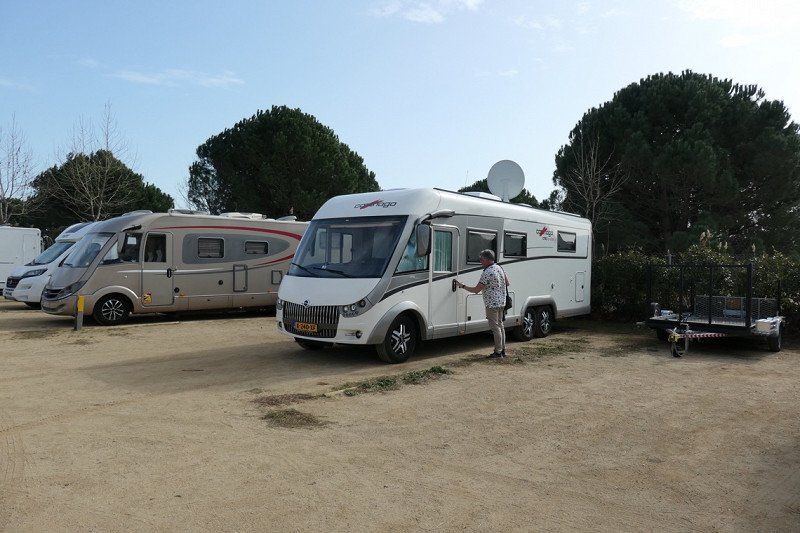
Two nights at Bonterra ResortWell-maintained campsite with fairly spacious pitches. If you come with a large camper, it is best to choose B6 or B7. There are 14 more spacious places We did not know this and went diagonally to D6 place 1 Most people are stuck here for 3 months We drove the Via Verde Del Mar with our E-scooterBeautiful route, also easy to do by bikeYou cycle from Benicassim to Oropesa. We walked around there for a while, nice place too
Av. Barcelona, 47, 12560 Benicàssim, Castelló, Spanje
40° 3' 26.1" N 0° 4' 29" E
40.0572384 0.0747132
• Head northwest. Go for 38 m.
• Turn left. Go for 103 m.
• Turn left toward Avenida de Barcelona. Go for 45 m.
• Turn right onto Avenida de Barcelona. Go for 437 m.
• Continue on Calle Santo Tomás. Go for 12 m.
• Continue toward Calle Santo Tomás. Go for 27 m.
• Take the 2nd exit from roundabout onto Calle Santo Tomás. Go for 107 m.
• Turn right onto Calle la Viña. Go for 151 m.
• Turn right onto Calle de Santa Águeda. Go for 234 m.
• Turn left toward E-15/AP-7/Valencia/Castellón. Go for 146 m.
• Turn right toward Castello/Castellón de la Plana/Valencia. Go for 19 m.
• Turn right onto N-340 toward Castellón/Castellón de la Plana/Valencia. Go for 7.3 km.
• Keep left onto N-340. Go for 7.6 km.
• Take ramp toward Univ. Jaume I/CV-151/Borriol/CV-10/CV-10/Valencia/Barcelona/Castelló/Castellón. Go for 465 m.
• Take the 1st exit from roundabout onto Carretera Morella (CV-151) toward CV-10. Go for 2.0 km.
• Take the 4th exit from roundabout onto CV-10 toward Betxí. Go for 10.8 km.
• Take exit 7 toward Vila-Real/Onda onto CV-20. Go for 826 m.
• Pass 5 roundabouts and continue on CV-20. Go for 5.0 km.
• Take the 4th exit from roundabout onto Avenida del Mediterráneo (CV-20) toward Onda. Go for 599 m.
• Pass 2 roundabouts and continue on Avenida del Mediterráneo (CV-20). Go for 1.5 km.
• Turn right onto Avenida Montendre (CV-20). Go for 151 m.
• Pass 2 roundabouts and continue on Avenida Montendre (CV-20). Go for 8.9 km.
• Turn right onto CV-194 toward Fanzara/Ludiente. Go for 1.5 km.
• Continue on Carretera Onda (CV-194). Go for 73 m.
• Turn right onto Calle Santo Sepulcro. Go for 6 m.
• Turn left onto Avenida José Antonio. Go for 41 m.
• Arrive at Avenida José Antonio. Your destination is on the right.
☍
48,2 km
( 43 min.)
Day
Day
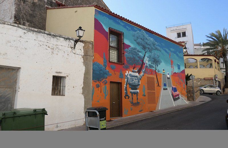
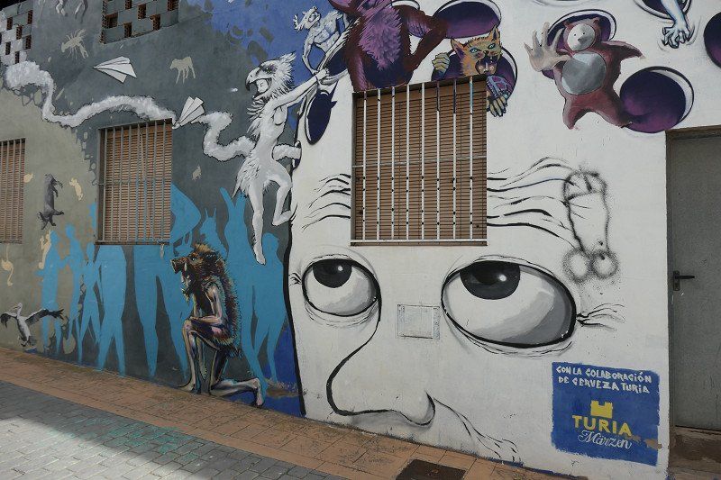
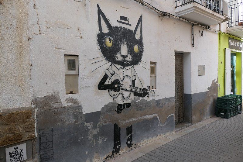
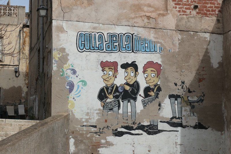
Fanzara, Spanje
Lots of street art. When we were there very quiet and so easily found a place to park the camper
12230 Fanzara, Castellón, Spanje
40° 1' 8.3" N 0° 18' 56.6" W
40.0189724 -0.3157348
• Head northwest on Avenida José Antonio. Go for 8 m.
• Turn right onto Plaza Obispo Granell. Go for 23 m.
• Turn right onto Plaza Obispo Granell. Go for 21 m.
• Turn right onto Plaza Obispo Granell. Go for 25 m.
• Turn left onto Avenida José Antonio. Go for 24 m.
• Turn right onto Calle Santo Sepulcro. Go for 6 m.
• Turn left onto Carretera Onda (CV-194). Go for 73 m.
• Continue on CV-194. Go for 1.5 km.
• Turn left onto CV-20. Go for 8.7 km.
• Pass 2 roundabouts and continue on Avenida Montendre (CV-20). Go for 407 m.
• Turn left onto Avenida del País Valenciano (CV-20) toward Villarreal/Castellón. Go for 1.0 km.
• Pass 6 roundabouts and continue on Avenida del Mediterráneo (CV-20). Go for 5.3 km.
• Take the 3rd exit from roundabout onto Avenida del Mediterráneo (CV-20) toward CV-10/Vila-real. Go for 718 m.
• Take the 2nd exit from roundabout onto CV-20 toward CV-10/Vila-real. Go for 349 m.
• Take ramp onto CV-10 toward Valencia/E-15/A-7/Betxí/Almenara. Go for 8.2 km.
• Continue on A-7 (Autovía del Mediterráneo). Go for 24.1 km.
• Continue on AP-7 (Autovía del Mediterráneo). Go for 8.8 km.
• Keep left onto V-21 toward Valencia (Norte)/Puçol/V-23/Sagunt/Sagunto. Go for 19.6 km.
• Take the 2nd exit from Plaza Cardenal Vicente Enrique y Tarancón roundabout onto Avenida de Aragón toward Estadi Mestalla/Av. Aragón/Av. d'Aragó/Grans Víes. Go for 749 m.
• Take the 2nd exit from roundabout onto Avenida de Aragón. Go for 209 m.
• Take the 3rd exit from Plaza Zaragoza roundabout. Go for 90 m.
• Continue on Puente de Aragón. Go for 208 m.
• Continue toward Avenida Jacinto Benavente. Go for 48 m.
• Turn left onto Avenida Jacinto Benavente toward Alicante/Alacant/Madrid/A-3/Ciudad de las Artes y Las Ciencias/El Saler. Go for 719 m.
• Continue on Calle del Alcalde Reig toward Ciudad de las Artes y Las Ciencias/El Saler. Go for 532 m.
• Take the 2nd exit from roundabout onto Avenida Profesor López Piñero (V-15) toward Madrid/Aeropuerto/A-3/Hospital La Fe/Ciutat de les Arts i les Ciències. Go for 107 m.
• Keep left onto Avenida Profesor López Piñero (V-15). Go for 3.4 km.
• Continue on CV-500. Go for 6.5 km.
• Pass 3 roundabouts and continue on Avenida de los Pinares (CV-500). Go for 6.4 km.
• Turn right. Go for 44 m.
• Arrive at your destination on the right.
☍
97,8 km
(1 hrs. 15 min.)
Devesa Gardens Camping & Resort
From here by bus to Valencia. ticket costs €1.50
Carretera de El Saler, Km. 13, 46012 València, Valencia, Spanje
39° 19' 22.4" N 0° 18' 35.8" W
39.3228780 -0.3099346
• Head toward Avenida de los Pinares. Go for 44 m.
• Turn right onto Avenida de los Pinares (CV-500). Go for 2.1 km.
• Pass 5 roundabouts and continue on CV-500. Go for 12.0 km.
• Continue on Avenida del Mar (CV-500). Go for 559 m.
• Take the 1st exit from roundabout onto Avenida Ribera Baixa (CV-500) toward Valencia/N-332/Alacant/CV-515/Algemesi. Go for 528 m.
• Take the 2nd exit from roundabout onto Avenida Ribera Baixa (CV-500) toward Valencia/N-332/Alacant/CV-515. Go for 852 m.
• Take the 4th exit from roundabout toward Láchar/Cullera/Alacant. Go for 139 m.
• Continue on Avenida de Gandient (N-332). Go for 143 m.
• Continue on Ronda de Sales (N-332). Go for 90 m.
• Continue on Ronda de España (N-332) toward Cullera/Alacant. Go for 381 m.
• Turn right onto Avenida Vila i Honor de Corbera (CV-509). Go for 457 m.
• Continue on CV-509. Go for 161 m.
• Take the 3rd exit from roundabout onto CV-509 toward Corbera/Llaurí/A-38/Gandia/València. Go for 177 m.
• Take the 3rd exit from roundabout onto A-38 toward Gandia. Go for 6.6 km.
• Take exit 19 toward E-15/AP-7/N-332/Cullera (sud)/Favara. Go for 349 m.
• Take the 2nd exit from roundabout onto N-332 toward Favara/E-15/AP-7. Go for 1.9 km.
• Take ramp onto AP-7 (Autopista del Mediterráneo) toward Alicante/Alacant. Go for 64.0 km.
• Take exit 63 toward N-332/Benissa/Teulada/Calp. Go for 1.6 km.
• Continue toward Variante de Benissa/N-332. Go for 35 m.
• Take the 3rd exit from roundabout onto Variante de Benissa (N-332) toward Teulada/Gata de Gorgos/Oliva/València. Go for 2.7 km.
• Take the 1st exit from roundabout onto Avenida de Europa (CV-740). Go for 286 m.
• Take the 2nd exit from roundabout onto Avenida de Europa (CV-740). Go for 276 m.
• Take the 3rd exit from roundabout onto Avenida de Europa (CV-740) toward Centre Urbà/Moraira. Go for 121 m.
• Take the 2nd exit from roundabout onto Avenida del Mediterráneo (CV-740). Go for 1.0 km.
• Take the 1st exit from Plaza Gabriel Miró roundabout onto Carretera de Morarira a Teulada (CV-743) toward Moraira. Go for 2.7 km.
• Pass 2 roundabouts and continue on Carretera de Morarira a Teulada (CV-743). Go for 2.0 km.
• Take the 1st exit from roundabout onto Calle Móstoles. Go for 263 m.
• Take the 2nd exit from roundabout onto Calle Móstoles. Go for 296 m.
• Turn sharp right onto Calle de Cullera. Go for 77 m.
• Arrive at Calle de Cullera. Your destination is on the right.
☍
102,0 km
(1 hrs. 15 min.)
Day
Day
La Sabatera, Spanje
see day 16
03724 La Sabatera, Alacant, Spanje
38° 41' 56.8" N 0° 7' 38.7" E
38.6991218 0.1274204
• Head northwest on Calle de Cullera.
• Arrive at Calle de Cullera. Your destination is on the right.
☍
Distance not available
(Duration not available)
Day
La Sabatera, Spanje
Near Moraira
We had a bit less weather here so we worked on a film
Beautiful places here, but unfortunately a lot of shade. in the summer you look great here
We drove around with the e-scooter.
Playa de L'Ampolla, Club Nautico, Cala del Portitxolet and finally Playa del Portrait. sat there on the terrace
03724 La Sabatera, Alacant, Spanje
38° 41' 56.8" N 0° 7' 38.7" E
38.6991218 0.1274204
• Head southeast on Calle de Cullera. Go for 26 m.
• Turn slightly right onto Calle de Cullera. Go for 51 m.
• Turn sharp left onto Calle Móstoles. Go for 266 m.
• Take the 2nd exit from roundabout onto Calle Móstoles. Go for 269 m.
• Take the 1st exit from roundabout onto Carretera de Morarira a Teulada (CV-743) toward Moraira. Go for 527 m.
• Take the 2nd exit from roundabout onto Carretera de Morarira a Teulada (CV-743) toward Moraira/Calp. Go for 479 m.
• Take the 1st exit from roundabout onto Carretera Moraira-Calpe (CV-746) toward Calp. Go for 1.8 km.
• Take the 2nd exit from roundabout onto Carretera Moraira-Calpe (CV-746). Go for 1.1 km.
• Take the 2nd exit from roundabout onto Avenida de la Marina (CV-746). Go for 6.1 km.
• Continue on Partida Pinamar (CV-746). Go for 235 m.
• Continue on CV-746. Go for 313 m.
• Continue on Partida Pinamar (CV-746). Go for 81 m.
• Continue on Urbanització Pinarmar (CV-746). Go for 240 m.
• Continue on Sector C-Urb. Calalga (CV-746). Go for 207 m.
• Continue on Urbanización Caleta (CV-746). Go for 469 m.
• Take the 1st exit from roundabout onto Calle Austria. Go for 219 m.
• Take the 2nd exit from roundabout onto Avenida Bulgaria. Go for 434 m.
• Continue on Urbanización Los Almendros. Go for 9 m.
• Continue on Avenida Bulgaria. Go for 176 m.
• Turn right toward Urbanización Los Almendros. Go for 15 m.
• Turn slightly left onto Urbanización Los Almendros. Go for 117 m.
• Continue on Sector G-Urb. Los Almendros. Go for 25 m.
• Continue on Sector F-Urb. Marysol Park. Go for 122 m.
• Turn slightly right onto Camino de Enchinent. Go for 113 m.
• Continue on Urbanización Marysol Park. Go for 127 m.
• Turn right onto Urbanización Enchinent. Go for 123 m.
• Continue on Urbanización Enchinent. Go for 207 m.
• Continue on Urbanización Enchinent. Go for 52 m.
• Arrive at Urbanización Enchinent. Your destination is on the right.
☍
13,9 km
( 24 min.)
Day
MarySol Camperpark, Partida Marisol Park, Calp, Spanje
Walked to the boulevard, grabbed a terrace and later visited the historic center
Partida Marisol Park, 43A, 03710 Calpe, Alicante, Spanje
38° 39' 0.1" N 0° 3' 45.8" E
38.6500301 0.0627315
• Head toward Urbanización Ortenbach on Urbanización Enchinent. Go for 20 m.
• Continue on Urbanización Marysol Park. Go for 44 m.
• Continue on Urbanización Ortenbach. Go for 142 m.
• Turn right onto Calle Enginent. Go for 83 m.
• Turn right onto Calle Enginent. Go for 110 m.
• Continue on Urbanización Marisol Park. Go for 407 m.
• Turn slightly left onto Sector K-Urb. Marysol Park. Go for 192 m.
• Take the 2nd exit from roundabout onto Avenida Polonia. Go for 338 m.
• Turn right onto Avenida de los Ejércitos Españoles (CV-746). Go for 265 m.
• Take the 4th exit from roundabout onto Avenida de los Ejércitos Españoles (CV-746). Go for 491 m.
• Continue on Avenida de la Marina (CV-746). Go for 241 m.
• Take the 1st exit from Rotonda Ti Marguí roundabout onto Calle del Penyal. Go for 134 m.
• Take the 2nd exit from roundabout. Go for 43 m.
• Continue on Avenida del Port. Go for 170 m.
• Keep right onto Avenida del Port. Go for 320 m.
• Take the 2nd exit from roundabout onto Avenida del Port. Go for 367 m.
• Arrive at your destination.
☍
3,4 km
( 8 min.)
Day
Penon de Ifach, Calp, Spanje
Piece of rock climbed to entrance rock. You can continue up but wear good shoes because it is climbing and clambering
Penon de Ifach, 03710 Calp, Alicante, Spanje
38° 38' 6" N 0° 4' 29" E
38.6350000 0.0747222
• Head northwest. Go for 122 m.
• Continue on Avenida del Port. Go for 208 m.
• Take the 1st exit from roundabout onto Avenida del Port. Go for 87 m.
• Turn right onto Calle Gibraltar. Go for 370 m.
• Turn left onto Calle Xábia. Go for 124 m.
• Take the 2nd exit from roundabout onto Avenida de la Marina (CV-746). Go for 369 m.
• Take the 1st exit from Rotonda Ti Marguí roundabout onto Avenida de la Marina (CV-746). Go for 300 m.
• Continue on Avenida de los Ejércitos Españoles (CV-746). Go for 377 m.
• Pass 3 roundabouts and continue on Avenida de los Ejércitos Españoles (CV-746). Go for 1.1 km.
• Take the 2nd exit from roundabout onto Avenida de la Diputación (CV-746). Go for 568 m.
• Pass 2 roundabouts and continue on Avenida de la Diputación (CV-746). Go for 630 m.
• Take left ramp onto N-332 toward Alacant/Alicante. Go for 7.2 km.
• Take ramp. Go for 2.1 km.
• Take left ramp onto AP-7 (Autopista del Mediterráneo) toward Alicante/Alacant. Go for 20.3 km.
• Take exit 66 toward La Vila Joiosa/Villajoyosa/N-332. Go for 1.3 km.
• Take the 2nd exit from roundabout onto CV-770 toward La Vila Joiosa/Villajoyosa/N-332/Alacant/Alicante/Valencia. Go for 692 m.
• Turn right. Go for 412 m.
• Turn left. Go for 501 m.
• Turn left. Go for 152 m.
• Turn right. Go for 163 m.
• Arrive at your destination.
☍
37,1 km
( 35 min.)
Day
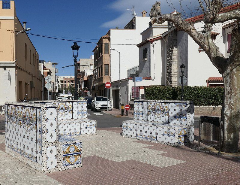
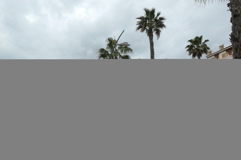
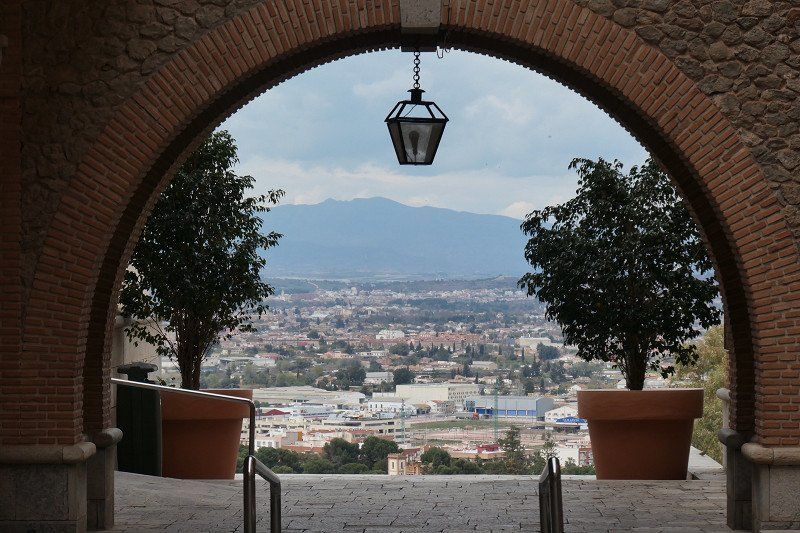
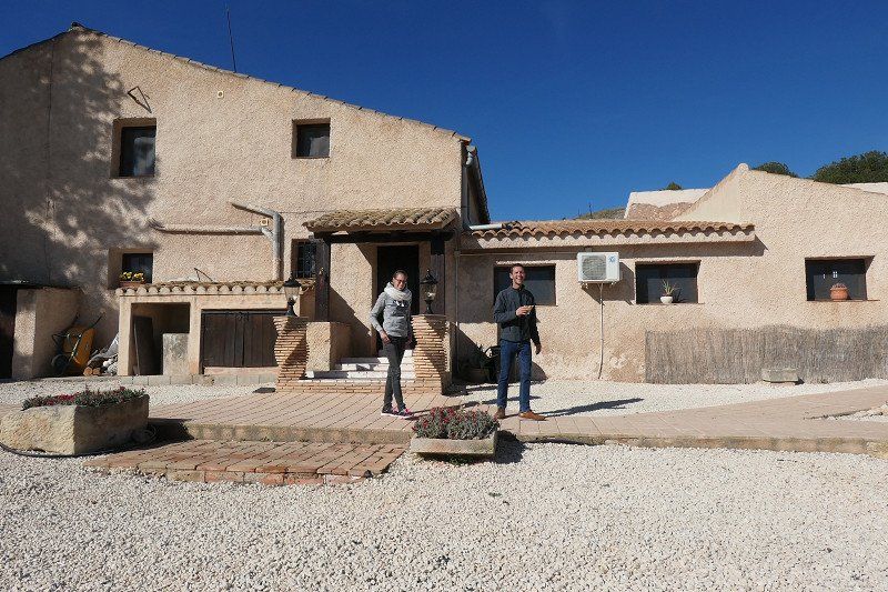
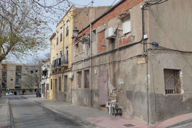
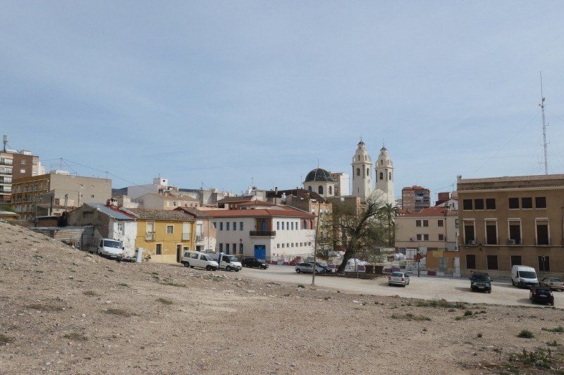
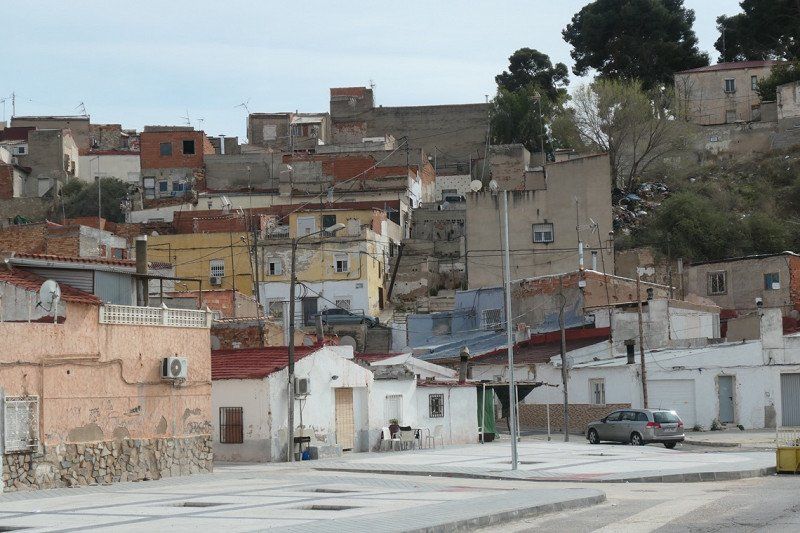
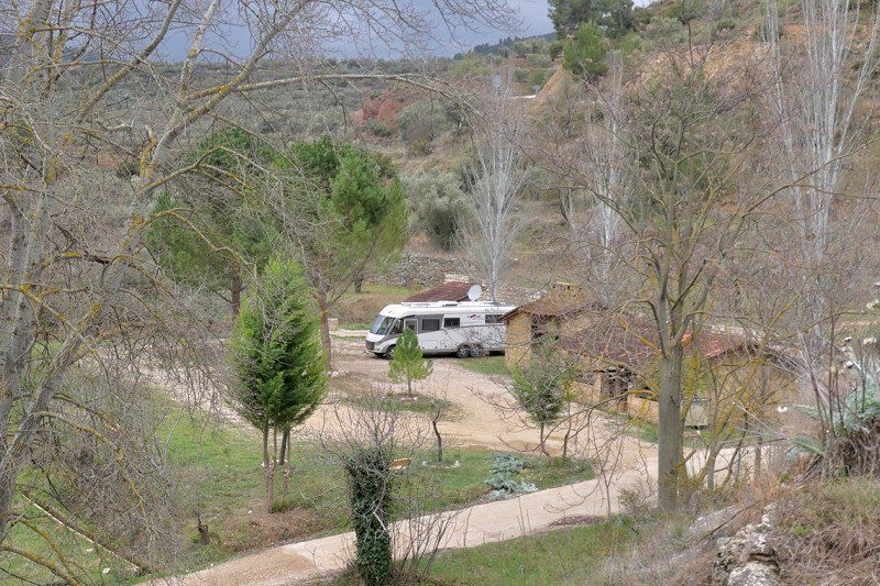
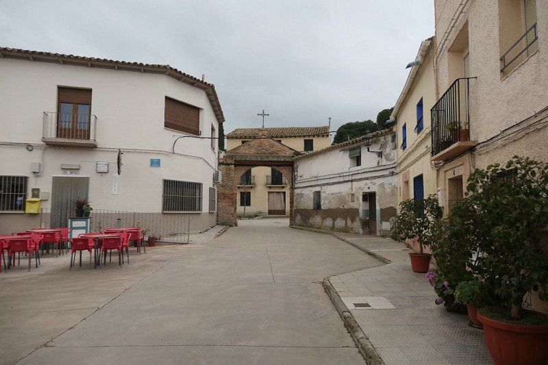
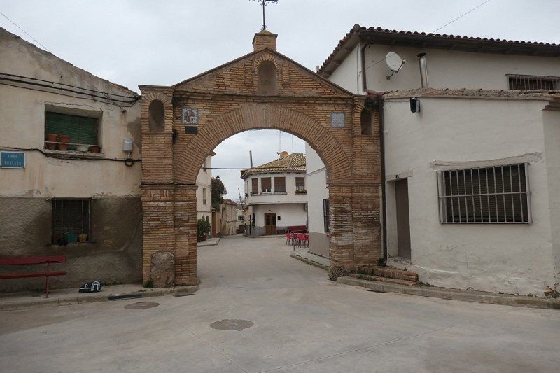
03570 Villajoyosa, Spanje
Camper place at villa We are here from Feb 22 to Mar 2 We had already booked the villa before Corona time, but despite all the craziness around it, we couldn't go there. Now we have a camper and can stand at the villa and Els, Demelza and Néva can stay in the villa. They fly to Alicante, we arrange a car with which they come to Villajoyosa. We will then go on trips together from Villajoyosa with the rental car And on 3 Mar we continue our journey So it will not go quite as planned We will see
from here visit by car:
Denia Part of the castle route Finally (we probably start here) we must not forget the castle of Dénia. This castle is not to be missed thanks to its construction on the highest point of the city. It is of Andalusian Muslim origin and dates from the 11th to 12th centuries. The castle has a rich history of wars and cultures that have tried to take possession of the castle. You should visit this castle just for the view and its picturesque view. For more information on opening times and events, visit the website: http://www.denia.es/va/index.a... If, after reading the eight castles, you still don't feel like you are in the Middle Ages , we strongly recommend that you start quickly with the route in which you can visit these eight beautiful and important castles. We can promise you, it's worth the trip!
Xàbia
It is recommended to drive from Denia over the Montgó ridge to Xàbia, through the CV-7361 route! The bay of Denia can be photographed beautifully from above, this also applies further on when Xàbia comes into view Jávea Natural Areas Network, one of the most beautiful stretches of coast on this part of the route There are brochures about the viewpoints at the tourist office, which you can best can visit by car or bicycle. If you have more time, you can of course also walk (about 25 km) Tourist Offices: Port, Pl Aldolfo Suarez, 11 Centrum, Plaça del'Esglesia, 4
Benissa
Old core, one of the best preserved historic city centers on the Costa Blanca
Beautiful routes for walking: Passeig ecològic, from Les Bassetes sailing club via the tourist office in the Casa dels Cent Vents, to the Cala Pinets. Second route further north from the Cala Llobella via the Platgeta de l'Advocat to the Cala del Baladrar
Paseo Ecológico, Benissa Via the Paseo ecológico from Benissa to Calpe The 'paseo ecológico' is a walking route that runs along the coastline of Benissa towards Calpe. It is a beautifully landscaped path, which is accessible all year round. In the warmer months it is also doable because the many groves and trees provide pleasant shade and therefore cooling. The route has a length of 4 kilometers and can be started in Calpe or in Benissa. It takes about an hour to walk the route from one of the departure points to the end. Because you probably park the car at one of the two starting points, it will take about 2 hours in total, without catering stops.
A route for young and old
There are many climbs and descents, but the well-laid path makes this very doable for both young and old. The various beautiful views ensure that you want to stop at each part to admire the view.
There are plenty of information boards along the walking route
There are several information boards along the route. These signs indicate what there is to see in terms of flora and fauna. Because it is a micro nature reserve, unique botanical species such as coarse thyme grow. These unique (wild) plants are explained on these signs. Various birds, starfish and other sea creatures have characterized this as their habitat and are therefore depicted and explained.
From Benissa to Calpe or vice versa
If you start the route from Benissa the first stop is Fustera beach. This is a beautiful white sand beach. Because there is a crystal clear seabed, the underwater life is beautifully portrayed here. The beach is reminiscent of a beach in Bali, the color is so beautiful. There is also a beach bar which is open all year round.
Paseo Ecológici goes along several bays
Then the route continues to Cala dels Pinets¨. This is a small and wild bay which consists of boulders and large flat rocks. Beautiful to see, less suitable for an afternoon stay given the hard surface.
Cultural heritage along the walking route
The route also contains elements of natural and cultural heritage. Think of the remains of an old quarry. It has been used in the construction of buildings such as the 'Sala del Consell' from the 16th century. This building can be found in the center of Benissa and was originally used as a storage and grain sales point in the Middle Ages.
The Paseo Ecológico offers a unique view of the special sea grass
During the route you will see several dark spots in the sea. These dark spots are caused by a type of sea grass. This is exclusive to the Mediterranean and is very special. This seagrass is a safe place for various marine species. It provides shelter to these marine species, they can feed on it and then reproduce. In addition, these plants also ensure that the water is filtered and they give the water oxygen. This is therefore an essential function.
In the fall, the seagrass leaves are renewed. The old leaves then wash up on the beach. This forms an accumulation on the beach which does not look nice but does have a function. In this way the sand of the beach is protected against the storms in the winter months. This makes it so important that these are only removed just before the new season in order to allow nature to fulfill its function.
Various catering facilities along the walking route
There are several bays on the route, so it is also an ideal outing to think about which bay you would like to stay at one of the following days. There are also various catering establishments to have a snack during or after the trip. A simple cup of coffee or a total lunch with paella, there is plenty to find during this fun but also unique route.
Helpful tips
Wear good shoes. The laid path is not always flat. Bring drinks. Large parts of the trail are exposed. Bring a camera. The route has many fantastic view locations. Bring a jacket. The wind can suddenly pick up along the coast.
Calpe
- Penyal d'Ifac rock is the symbol of this old fishing town - Roman ruins on the beach of L'Arenal-Bol - Salt mines on the outskirts with migratory birds - old Moorish quarter El Arrabal with historic character. In the crooked streets you can admire paintings and mosaics on the walls of the houses - in the afternoon the fishermen return to the harbor and you can attend the auction of the fish
Altea
One of the most beautiful walks (or cycle route) goes along the Platja de L'Albir and further over the cliffs to the lighthouse of L'Alfàs
You can also make beautiful trips over the Serra de Bèrnia or through the vegetable gardens around Altea
Finestrat
Village of white houses, huddled on a hill at the bottom of the 1410 meter high Puig Campana. While strolling through the winding alleys and small squares, one can easily imagine what life was like here in the time of the Moors
Alicante
7. The Castle of Santa Barbara (Alicante) The famous castle of Alicante, in the middle of the city, is located on the Benacantil mountain. This beautiful castle, which is in excellent condition, is 166 meters high. When you are at the highest point of the castle, you really have a breathtaking view over Alicante and the bay of Alicante. This 9th century castle was built by Muslims and was conquered in the 13th century by the Infante Alfonso de Castilla. This day, December 14 (1248), has been declared Santa Barbara Day. This castle with a rich history is definitely worth a visit. For more information regarding opening times and events, visit the website: https://www.castillodesantabar... 8. The castle of Dénia This is where we started, or at least that's the plan
03570 Villajoyosa, Alicante, Spanje
38° 30' 58.5" N 0° 15' 9.4" W
38.5162521 -0.2526163
• Head north. Go for 163 m.
• Turn left. Go for 152 m.
• Turn right. Go for 501 m.
• Turn right toward CV-770. Go for 412 m.
• Turn left onto CV-770. Go for 620 m.
• Turn right toward CV-770. Go for 30 m.
• Take the 2nd exit from roundabout toward Alacant/Alicante/Valencia. Go for 95 m.
• Take ramp onto AP-7 (Autopista del Mediterráneo) toward Alicante/Alacant. Go for 16.7 km.
• Keep right onto AP-7 (Autovía del Mediterráneo) toward A-70/Alacant/Alicante/Murcia/Madrid. Go for 5.0 km.
• Continue on A-70 (Autovía del Mediterráneo). Go for 21.0 km.
• Take exit 26 toward Torrellano/N-340/El Altet/N-332/Santa Pola/Aeropuerto onto N-338. Go for 5.0 km.
• Take the exit toward El Altet/Santa Pola onto N-332 (Carretera del Aeropuerto). Go for 5.9 km.
• Take ramp. Go for 601 m.
• Take the 4th exit from roundabout onto Avenida Noruega. Go for 1.6 km.
• Take the 2nd exit from roundabout onto Avenida Noruega. Go for 242 m.
• Arrive at Avenida Noruega. Your destination is on the right.
☍
57,9 km
( 42 min.)
Day
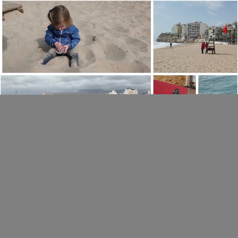
Villajoyosa
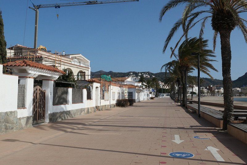
Stroll along the boulevard in Villajoyosa
Day
markt Villajoyosa
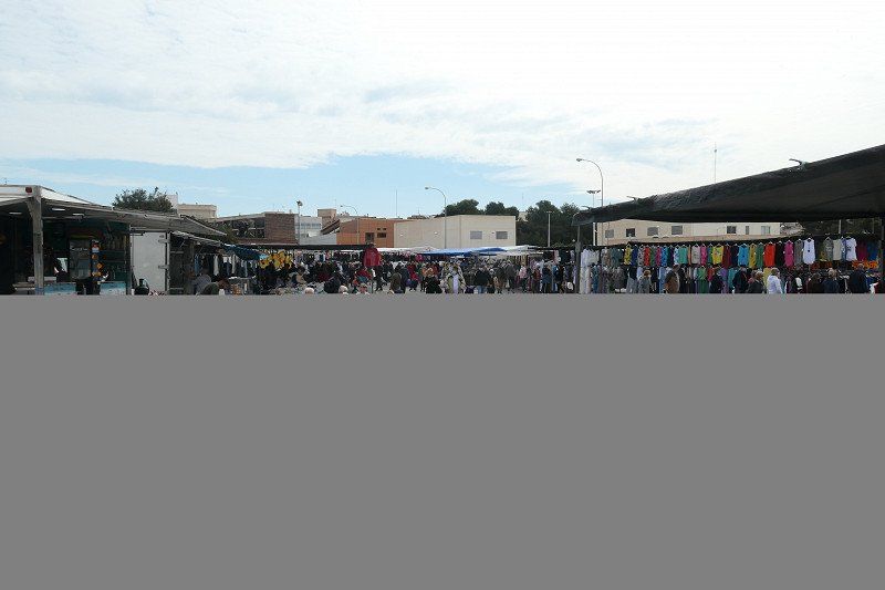
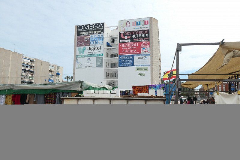
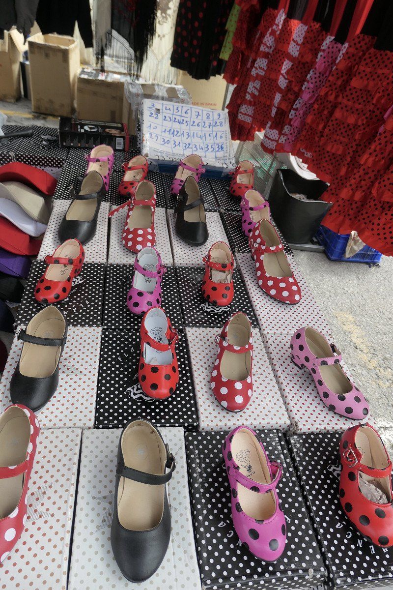
Went to the market in Villajoyosa, got dresses and heels for the grandchildren
Day
Guadalest
beautiful route driven to Guadalest
Villajoyosa, Reservoir at Bella Orcheta, Orxeta, Sella, Alcoleja, Benasau, Confrides, Guadalest, Algar Waterfalls, La Nucia, Benidorm, Villajoyosa
We had a rental car so it was doable. Very nice route
Day
Day
Day
Benidorm
Went to Benidorm for a few hours, quite nice
Day
Day
villajoyosa
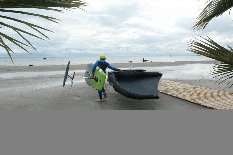
Experienced rescue exercise of the Guardia Civil, helicopter, boat, ambulance and especially many people
Exercise was in front of us on the beach
Photo collage is a memory of our being together with Els, Demelza and Néva
Day
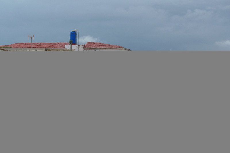
Carabassí Casas Inmobiliaria Estate Agency, Santa Pola, Spanje
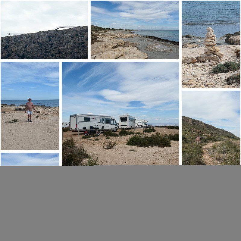
Nice location to stand with the camper
There is an official camper place, but you can also stand very nicely along the coast
When we were there, that was tolerated
Avenida Noruega 174 Novamar Centro Local 3a, 03130 Santa Pola, Alicante, Spanje
38° 14' 20.3" N 0° 31' 43.7" W
38.2389718 -0.5288123
• Head southwest on Avenida Noruega. Go for 170 m.
• Take the 1st exit from roundabout onto Avenida Noruega. Go for 1.6 km.
• Take the 1st exit from roundabout. Go for 231 m.
• Keep left toward N-332. Go for 204 m.
• Take ramp onto N-332. Go for 4.3 km.
• Take ramp toward Elx. Go for 279 m.
• Take the 1st exit from roundabout onto CV-865 toward Elx. Go for 144 m.
• Turn right. Go for 24 m.
• Arrive at your destination on the left.
☍
7,0 km
( 10 min.)
Day
Day
Camping Bahía de Santa Pola, Carretera Santa Pola - Elche, Santa Pola, Spanje
Here we first washed the camper, there was a kind of car wash. Great to do
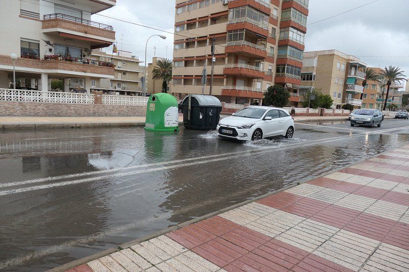
Camper had become quite dirty due to the rain at the coast. Were there on a kind of grafted surface full of puddles.
It rained quite a bit here at night, streets were flooded and large puddles
Carretera Santa Pola - Elche, Km 11, 03130 Santa Pola, Alicante, Spanje
38° 12' 2.4" N 0° 34' 12.1" W
38.2006640 -0.5700354
• Head southwest. Go for 24 m.
• Turn right onto CV-865. Go for 269 m.
• Take the 4th exit from roundabout onto CV-865 toward N-332/Cartagena/Alacant/Santa Pola. Go for 530 m.
• Take the 1st exit from roundabout onto N-332 toward Cartagena. Go for 2.2 km.
• Turn left onto Calle Venida de la Virgen. Go for 90 m.
• Turn left onto Avenida Tamarit. Go for 188 m.
• Turn right onto Calle Misterio de Elche. Go for 259 m.
• Turn right onto Avenida Vicente Blasco Ibáñez. Go for 444 m.
• Arrive at Avenida Vicente Blasco Ibáñez. Your destination is on the left.
☍
4,0 km
( 6 min.)
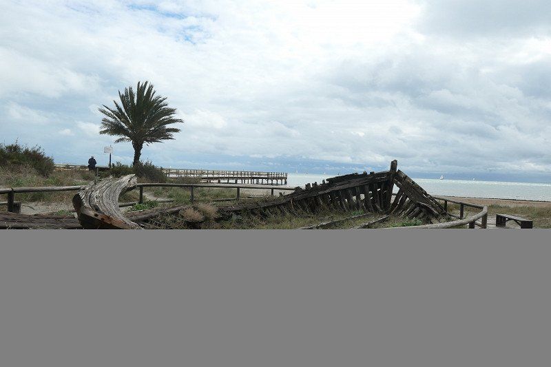
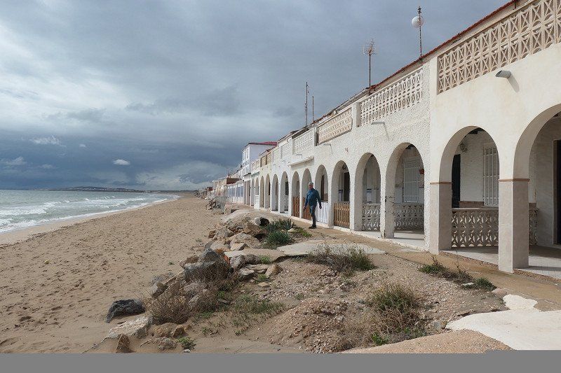
Embarcadero Playa de La Gola
Did a walk at Playa del Tamarit. At the salt mountains. Easy to do from the campsite. Total about 11 km
Walk to the starting point was already spectacular. So much water had fallen that several streets were flooded
Calle 8, s/n, 03006 Alicante (Alacant), Alicante, Spanje
38° 11' 20" N 0° 35' 32.8" W
38.1888997 -0.5924463
• Head northeast on Avenida Vicente Blasco Ibáñez. Go for 286 m.
• Turn left onto Calle Venida de la Virgen. Go for 301 m.
• Turn left onto Partida Baya Baja (N-332). Go for 5.2 km.
• Take ramp toward La Marina. Go for 213 m.
• Take the 3rd exit from roundabout onto N-332 toward La Marina. Go for 279 m.
• Continue on Carretera de Cartagena a Alicante (N-332a). Go for 1.2 km.
• Take the 3rd exit from roundabout onto Camino del Pinet toward El Pinet. Go for 1.2 km.
• Turn right toward Partida Marina. Go for 196 m.
• Turn left onto Partida Marina. Go for 126 m.
• Arrive at Partida Marina. Your destination is on the right.
☍
9,0 km
( 12 min.)
Day
Day
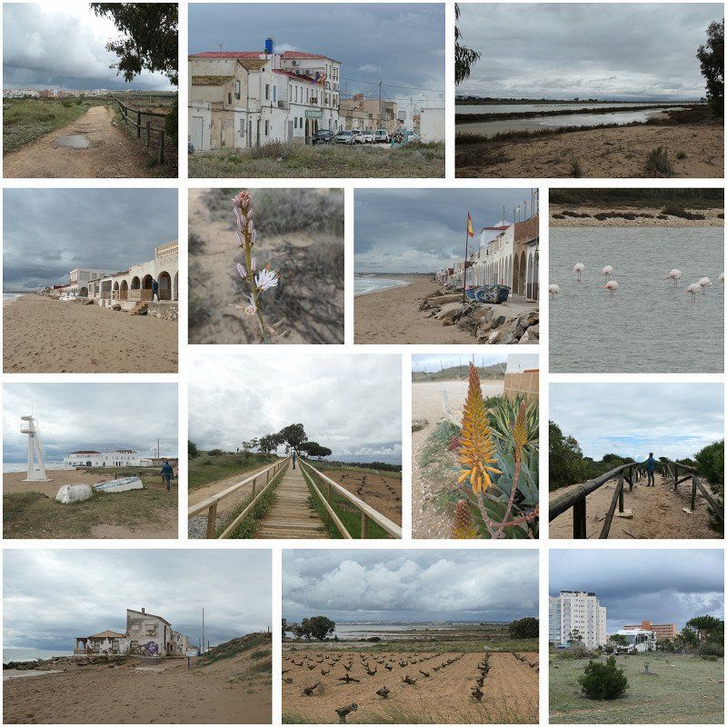
Playa de El Pinet, Elx, Spanje
nice walk through the nature reserve, dunes and beach.
especially nice because of the fishermen's houses on the beach
Playa de El Pinet, 03194 Elche, Alicante, Spanje
38° 9' 4.5" N 0° 37' 44.6" W
38.1512547 -0.6290528
• Head southwest on Partida Marina. Go for 126 m.
• Turn right toward Camino del Pinet. Go for 196 m.
• Turn left onto Camino del Pinet. Go for 1.1 km.
• Take the 3rd exit from roundabout onto Carretera Cartagena-Alicante (N-332a) toward Centro Ciudad/La Marina. Go for 1.5 km.
• Continue on Avenida de la Alegría (N-332a). Go for 1.2 km.
• Continue on N-332a. Go for 490 m.
• Take ramp onto N-332. Go for 688 m.
• Pass 6 roundabouts and continue on N-332. Go for 9.8 km.
• Take the 2nd exit from roundabout onto N-332 toward Torrevieja/Cartagena. Go for 1.2 km.
• Take the 1st exit from roundabout onto Camino del Cementerio. Go for 63 m.
• Turn right. Go for 97 m.
• Turn sharp left. Go for 163 m.
• Arrive at your destination on the right.
☍
16,6 km
( 21 min.)
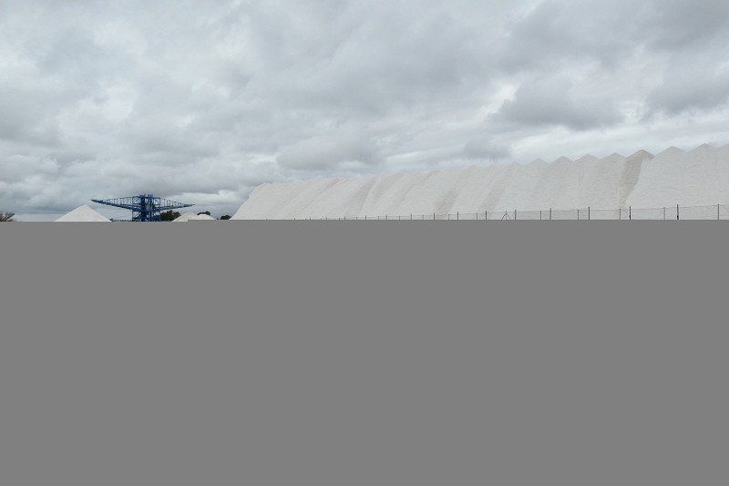
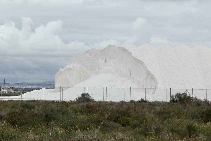
Salinas van Torrevieja en La Mata
also had a nice walk here
Photo collage is Playa del Pinet and Salinas of Torrevieja and La Mata
Ctra. Nacional, s/n, 03188 Torrevieja, Alicante, Spanje
38° 1' 30.9" N 0° 39' 30.6" W
38.0252417 -0.6584930
• Head toward Camino de la Cañada Real de la Costa. Go for 163 m.
• Turn sharp right toward Camino del Cementerio. Go for 97 m.
• Turn left onto Camino del Cementerio. Go for 39 m.
• Take the 1st exit from roundabout onto Carretera de Alicante (N-332) toward Torrevieja/Cartagena. Go for 1.3 km.
• Take the 1st exit from roundabout onto Carretera de Circunvalación (N-332) toward Torrevieja/Cartagena. Go for 194 m.
• Keep left onto Carretera de Circunvalación (N-332). Go for 8.6 km.
• Take the 3rd exit from roundabout onto N-332 toward Cartagena. Go for 1.3 km.
• Take the 4th exit from roundabout onto N-332. Go for 915 m.
• Turn right onto Calle Fragata toward Punta Prima. Go for 178 m.
• Arrive at Calle Fragata. Your destination is on the right.
☍
12,9 km
( 16 min.)
Orihuela, Spanje
Stay overnight at Punta Prima, very nice spot via park4night.
Officially you can only park here on the day, but we took the gamble and were not sent away
Plaça D-1 la Mosca y la Campana, 10, 03189 Orihuela, Alicante, Spanje
37° 56' 33.4" N 0° 42' 56.4" W
37.9425979 -0.7156721
• Head toward Calle Cliper on Calle Fragata. Go for 178 m.
• Turn right onto N-332. Go for 497 m.
• Take the 5th exit from roundabout onto N-332 toward Cartagena. Go for 1.4 km.
• Take the 2nd exit from roundabout onto N-332 toward Cartagena. Go for 1.5 km.
• Take the 2nd exit from roundabout onto Carretera de Villamartín toward AP-7/Alicante/Cartagena. Go for 308 m.
• Take the 2nd exit from roundabout onto Carretera de Villamartín. Go for 266 m.
• Turn right toward Calle del Ópalo. Go for 57 m.
• Turn left onto Calle del Ópalo. Go for 18 m.
• Turn right onto Calle del Ópalo. Go for 54 m.
• Keep left onto Calle del Ópalo toward Villamartin. Go for 35 m.
• Take the 5th exit from roundabout onto AP-7 (Autopista del Mediterráneo) toward San Pedro del Pinatar/Cartagena. Go for 18.3 km.
• Take exit 782 toward Balsicas/Murcia onto RM-19. Go for 25.6 km.
• Take ramp onto A-30 (Autovía de Murcia) toward Murcia. Go for 9.9 km.
• Take exit 148 toward La Alberca. Go for 374 m.
• Take the 2nd exit from roundabout toward Murcia/La Alberca/RM-302. Go for 219 m.
• Keep right toward RM-302/Costera Sur/La Alberca/Santo Ángel/Beniaján. Go for 717 m.
• Take the 2nd exit from roundabout onto Avenida Ocho de Marzo toward Murcia/Algezares. Go for 2.4 km.
• Turn right onto Carretera de la Fuensanta (F-3). Go for 240 m.
• Continue on Calle del Buitre. Go for 475 m.
• Turn left onto Calle Cresta del Gallo. Go for 278 m.
• Continue on Calle Subida de la Fuensanta. Go for 221 m.
• Turn sharp right toward Santuario de la Fuensanta. Go for 169 m.
• Turn slightly right onto Santuario de la Fuensanta. Go for 17 m.
• Turn sharp left. Go for 109 m.
• Arrive at your destination on the right.
☍
63,3 km
( 47 min.)
Day
Murcia, Spanje
Driven to Santurio Ntr. sr. de la Fuensanta
Beautiful cathedral built in Baroque style
Urbanizacion la Fuensanta, 8, 30157 Murcia, Spanje
37° 56' 15.4" N 1° 7' 5.9" W
37.9376043 -1.1182984
• Head toward Santuario de la Fuensanta. Go for 122 m.
• Turn right. Go for 38 m.
• Turn left. Go for 50 m.
• Turn left toward Calle Subida de la Fuensanta. Go for 90 m.
• Continue on Calle Subida de la Fuensanta. Go for 204 m.
• Continue on Calle Pájaro. Go for 661 m.
• Turn left onto Carretera La Alberca (RM-302). Go for 68 m.
• Continue on Carretera de la Alberca (RM-302). Go for 76 m.
• Continue on Carretera La Alberca (RM-302). Go for 26 m.
• Continue on Carretera de la Alberca (RM-302). Go for 55 m.
• Continue on Carretera La Alberca (RM-302). Go for 40 m.
• Continue on Carretera de la Alberca (RM-302). Go for 386 m.
• Turn right onto Carretera de la Fuensanta (F-3). Go for 2.7 km.
• Continue on Calle Félix. Go for 66 m.
• Keep left toward Ronda Sur. Go for 18 m.
• Turn left onto Ronda Sur toward A-7/E-15/A-30/Carretera de Santa Catalina/El Palmar/N-301a. Go for 551 m.
• Take ramp onto A-30 (Carretera de Madrid-Albacete) toward Andalucía/Alicante/Albacete. Go for 8.6 km.
• Take exit 134 toward Molina de Segura/Albacete onto A-30 (Autovía de Murcia). Go for 30.6 km.
• Take exit 105 toward Cieza/Cieza Hospital. Go for 541 m.
• Take the 1st exit from roundabout onto N-301 toward Cieza Hospital/Cieza. Go for 3.7 km.
• Take the 3rd exit from roundabout toward Cieza. Go for 236 m.
• Continue on Avenida Diego Jiménez Castellanos. Go for 235 m.
• Take the 2nd exit from roundabout onto Avenida Diego Jiménez Castellanos. Go for 326 m.
• Take the 2nd exit from Plaza San Juan Bosco roundabout onto Avenida de Italia. Go for 235 m.
• Take the 1st exit from Plaza de las Cortes Españolas roundabout onto Gran Vía Juan Carlos I. Go for 405 m.
• Arrive at Gran Vía Juan Carlos I. Your destination is on the left.
☍
50,1 km
( 45 min.)
Cieza, Spanje
Went to Cieza to admire the peach blossom there
Disappointing but still able to enjoy it between the orchards. Blossom had almost finished flowering.
You could still see the pink plains and so quite beautiful to drive through
Calle Juan Carlos I, Gran Via, 2, 30530 Cieza, Murcia, Spanje
38° 14' 31.5" N 1° 25' 18.2" W
38.2420912 -1.4217274
• Head toward Camino de la Estación on Gran Vía Juan Carlos I. Go for 172 m.
• Continue on Carretera de Madrid. Go for 794 m.
• Continue on Carretera Incorporación a N-301. Go for 277 m.
• Turn right toward A-30/Murcia. Go for 25 m.
• Turn sharp right onto N-301. Go for 1.5 km.
• Pass 3 roundabouts and continue on N-301. Go for 5.9 km.
• Take ramp toward Abarán/A-30/Murcia/Albacete. Go for 414 m.
• Take the 3rd exit from roundabout onto MU-513 toward Murcia/A-30/Albacete. Go for 2.9 km.
• Continue on Carretera Abarán. Go for 216 m.
• Take ramp onto N-344. Go for 205 m.
• Continue on Carretera Jumilla (N-344). Go for 643 m.
• Continue on N-344. Go for 1.3 km.
• Take the 2nd exit from roundabout onto N-344. Go for 6.7 km.
• Take the 2nd exit from roundabout onto Cañada de la Zarza-Trigo (RM-A10) toward La Zarza/A-33/Jumilla/Yecla/Valencia. Go for 172 m.
• Take the 1st exit from roundabout onto Cañada de la Zarza-Trigo (RM-A10) toward La Zarza. Go for 3.6 km.
• Continue on RM-A10. Go for 648 m.
• Continue on El Boquerón (RM-A10). Go for 168 m.
• Continue on RM-A10. Go for 11.7 km.
• Continue on La Zarza (RM-A10). Go for 102 m.
• Continue on RM-A10. Go for 2.2 km.
• Continue on La Zarza (RM-A10). Go for 146 m.
• Continue on RM-A10. Go for 2.4 km.
• Turn left. Go for 213 m.
• Arrive at your destination on the right.
☍
42,4 km
( 39 min.)
Onbekend, Spanje
stay overnight at Finca Guillermo Murcia
Beautiful place, run by a Belgian couple, Wim and Ilse
They have only been the proud owners of this B&B since August, but they also offer 3 camper pitches
you look really fantastic there
Wim used to be a cook and offers his guests to join the surprise menu in the evening.
You are obliged to have breakfast there, but that's fine, the price is to it and it is nice and easy
We also enjoyed the surprise dinner and it was delicious
Diseminado Cañada Trigo, 33, 30529, Murcia, Spanje
38° 19' 54.1" N 1° 6' 16.6" W
38.3316876 -1.1046001
• Head east. Go for 213 m.
• Turn left onto RM-A10. Go for 4.1 km.
• Turn right onto RM-422 toward Abanilla/Fortuna/Murcia. Go for 7.1 km.
• Turn left onto MU-410. Go for 1.6 km.
• Continue on Avenida Generalísimo (MU-410). Go for 136 m.
• Continue on Carretera Murcia-Barinas (MU-410). Go for 408 m.
• Continue on Avenida de España (MU-410). Go for 395 m.
• Continue on MU-410. Go for 2.4 km.
• Continue on Calle San Juan Bautista (MU-410). Go for 1.1 km.
• Continue on MU-410. Go for 4.6 km.
• Continue on CV-845. Go for 3.2 km.
• Continue on Avenida Barbarroja (CV-845) toward Barbarroja. Go for 156 m.
• Continue on Avenida de la Constitución (CV-845). Go for 315 m.
• Turn right onto Avenida Albatera (CV-873). Go for 111 m.
• Continue on CV-873. Go for 2.0 km.
• Continue on Carretera Hondón de los Frailes (CV-873). Go for 10.5 km.
• Continue on Avenida Hondón de los Frailes (CV-873). Go for 335 m.
• Take the 2nd exit from roundabout onto Avenida Hondón de los Frailes (CV-873). Go for 192 m.
• Turn left onto Avenida País Valenciano (N-340) toward A-7. Go for 8.2 km.
• Turn right onto Carretera Murcia-Alicante. Go for 59 m.
• Continue straight ahead. Go for 68 m.
• Arrive at your destination on the left.
☍
47,2 km
( 43 min.)
Day
Crevillente, Spanje
C. Equipamientos H2, 22, 03339 Crevillente, Alicante, Spanje
38° 14' 25.8" N 0° 48' 43.9" W
38.2404930 -0.8121981
• Head toward Calle Equipamientos H2. Go for 40 m.
• Turn left toward Calle Gutiérrez de Cárdenas/N-340. Go for 17 m.
• Turn right onto Calle Gutiérrez de Cárdenas (N-340). Go for 2.0 km.
• Take the 3rd exit from roundabout onto Paseo de Elche (A-78). Go for 985 m.
• Take the 4th exit from roundabout onto Paseo de Elche (A-78). Go for 1.5 km.
• Take the 2nd exit from roundabout onto Carretera de Crevillente (A-78). Go for 253 m.
• Take ramp onto A-7 (Autovía del Mediterráneo) toward Alacant/Alicante/Valencia/Madrid. Go for 9.9 km.
• Keep left onto A-70 (Autovía del Mediterráneo) toward Alacant/Alicante. Go for 8.9 km.
• Take exit 22 toward Torrellano/N-340/N-332/El Altet/Santa Pola/Aeropuerto onto N-338. Go for 4.6 km.
• Take the exit toward El Altet/Santa Pola onto N-332 (Carretera del Aeropuerto). Go for 973 m.
• Take ramp toward El Altet/N-332. Go for 762 m.
• Take the 3rd exit from roundabout onto Calle San Francisco de Asís. Go for 390 m.
• Turn right onto Avenida Cartagena. Go for 608 m.
• Turn slightly left onto Carretera de Arenales del Sol. Go for 1.8 km.
• Turn right onto Calle Gran Vía. Go for 495 m.
• Take the 2nd exit from roundabout. Go for 147 m.
• Continue on Calle Bahía. Go for 339 m.
• Continue on Calle Bahía. Go for 231 m.
• Take the 2nd exit from roundabout onto Calle Bahía. Go for 552 m.
• Take the 2nd exit from roundabout onto Calle de Albacete. Go for 891 m.
• Take the 2nd exit from roundabout onto Avenida San Bartolomé de Tirajana. Go for 554 m.
• Turn left onto Camino del Carabassí. Go for 3.0 km.
• Arrive at your destination on the left.
☍
38,9 km
( 34 min.)
Day
Day
Caleta dels Gossets, Camino del cabo, Santa Pola, Spanje
Lovely place by the sea, you can enjoy a nice walk here
Cam. del cabo, 03130 Santa Pola, Alicante, Spanje
38° 12' 52.3" N 0° 30' 27.5" W
38.2145177 -0.5076437
• Head north. Go for 1.1 km.
• Continue on Camino del Carabassí. Go for 1.8 km.
• Turn right onto Avenida San Bartolomé de Tirajana. Go for 503 m.
• Take the 2nd exit from roundabout onto Calle de Albacete. Go for 906 m.
• Take the 4th exit from roundabout onto Calle Bahía. Go for 589 m.
• Take the 2nd exit from roundabout onto Calle Bahía. Go for 311 m.
• Continue on Calle Bahía. Go for 323 m.
• Keep left toward Calle Gran Vía. Go for 55 m.
• Take the 2nd exit from roundabout onto Calle Gran Vía. Go for 492 m.
• Take the 3rd exit from roundabout onto Carretera de Arenales del Sol. Go for 1.8 km.
• Continue on Avenida Cartagena. Go for 957 m.
• Take the 2nd exit from roundabout onto Avenida Cartagena. Go for 407 m.
• Continue on Carretera del Aeropuerto (N-332). Go for 261 m.
• Take ramp onto N-338 (Carretera del Aeropuerto) toward Aeropuerto/A-70/Valencia/València/Murcia/A-31/Madrid. Go for 4.8 km.
• Take the left exit toward Elx/Elche/Murcia/A-31/Madrid onto A-70 (Autovía del Mediterráneo). Go for 8.4 km.
• Take exit 34 toward Monforte del Cid/Madrid onto EL-20 (Ronda Este de Elche). Go for 1.5 km.
• Continue on A-7 (Circunvalación de Alicante). Go for 6.5 km.
• Continue on A-31 (Autovía Alicante). Go for 6.8 km.
• Take exit 216 toward Novelda (Sur)/Agost/Novelda. Go for 516 m.
• Take the 3rd exit from roundabout onto CV-820 toward Novelda. Go for 132 m.
• Take the 1st exit from roundabout onto Avenida Jesús Navarro Jover (CV-820) toward Novelda. Go for 370 m.
• Take the 3rd exit from roundabout onto Avenida Jesús Navarro Jover (CV-820). Go for 350 m.
• Take the 3rd exit from roundabout onto Avenida Jesús Navarro Jover (CV-820). Go for 323 m.
• Continue on CV-820. Go for 25 m.
• Take the 3rd exit from roundabout onto Avenida Médico Enrique Sala. Go for 282 m.
• Take the 3rd exit from roundabout onto Avenida Pérez Galdós (N-325). Go for 245 m.
• Continue on N-325. Go for 44 m.
• Take the 1st exit from Plaza Juan XXIII roundabout onto N-325. Go for 47 m.
• Continue on Avenida de la Constitución (N-325). Go for 582 m.
• Pass 2 roundabouts and continue on Avenida de la Constitución (N-325). Go for 188 m.
• Turn right onto Calle Jaume II. Go for 251 m.
• Arrive at Calle Jaume II. Your destination is on the right.
☍
41,0 km
( 38 min.)
Day
Day
Novelda, Spanje
5. La Mola . Castle
La Mola Castle, declared a National Monument in 1931, is located on the outskirts of Novelda. The Islamic castle has its origins in the 12th century. It is particularly notable for its special construction with a triangular tower and a square plan. Entry to this castle is free.
Visit the website for more information regarding opening times and events:
http://www.novelda.esconoce-novelda/museos-y-monumentos/
Also view cathedral there, Gaudí
03660 Novelda, Alicante, Spanje
38° 23' 2.8" N 0° 46' 0.6" W
38.3841032 -0.7668469
• Head north on Calle Jaume II. Go for 94 m.
• Turn left onto Calle Emilio Castelar. Go for 76 m.
• Turn right onto Calle San Fernando. Go for 49 m.
• Continue on Plaza Glorieta. Go for 101 m.
• Continue on Calle Valencia. Go for 377 m.
• Turn right onto Calle San Juan de la Cruz. Go for 237 m.
• Continue on Calle Pablo Sarasate. Go for 146 m.
• Turn right onto Calle José Noguera (N-325). Go for 58 m.
• Take the 3rd exit from roundabout onto Calle José Noguera (N-325). Go for 1.1 km.
• Continue on N-325. Go for 1.1 km.
• Take left ramp onto A-31 (Autovía Alicante) toward Elda/Almansa/Albacete. Go for 5.9 km.
• Take exit 207 toward Elda (Sur)/CV-83/Monóvar. Go for 287 m.
• Continue toward Carretera a Alicante. Go for 33 m.
• Take the 2nd exit from roundabout onto Carretera a Alicante toward Elda. Go for 795 m.
• Take the 2nd exit from roundabout onto Carretera a Alicante. Go for 884 m.
• Continue on Avenida Ruperto Chapí. Go for 596 m.
• Turn left onto Calle Virgen de los Desamparados. Go for 74 m.
• Turn right onto Calle Aragón. Go for 236 m.
• Turn right onto Calle Lolita Miralles Esteve. Go for 74 m.
• Turn right onto Calle Antonio Maura. Go for 59 m.
• Arrive at Calle Antonio Maura. Your destination is on the right.
☍
12,3 km
( 16 min.)
Elda, Spanje
4. The castles of Elda and Petrer
Going a little further south, we find two castles in the towns of Elda and Petrer. The castle in Elda is of Arab origin
We went to Elda, was disappointing. It seemed very shabby to us
Elda, Alicante, Spanje
38° 28' 35.4" N 0° 47' 47.3" W
38.4765073 -0.7964597
• Head south on Calle Antonio Maura.
• Turn right onto Calle Paquito Vera. Go for 113 m.
• Turn right onto Calle Lamberto Amat. Go for 125 m.
• Continue on Calle de San José de Calasanz. Go for 246 m.
• Turn right onto Avenida de Novo (CV-833). Go for 381 m.
• Continue on Avenida de Novo. Go for 91 m.
• Take the 2nd exit from roundabout onto Paseo de la Mora. Go for 675 m.
• Take the 3rd exit from roundabout onto Puente de la Libertad. Go for 344 m.
• Continue on Avenida de la Libertad. Go for 344 m.
• Keep right onto Calle Romero (CV-835) toward Alicante/A-31/N-330. Go for 300 m.
• Take the 2nd exit from roundabout onto Carretera Acceso Autovía (CV-835). Go for 1.1 km.
• Take ramp toward Albacete/Madrid. Go for 597 m.
• Take the 2nd exit from roundabout onto A-31 (Autovía Alicante) toward Madrid. Go for 29.1 km.
• Take exit 172 toward Yecla/Murcia onto A-33. Go for 17.2 km.
• Take exit 61 toward Yecla. Go for 420 m.
• Take the 1st exit from roundabout onto RM-425 toward Yecla. Go for 1.9 km.
• Take the 1st exit from roundabout onto RM-425 toward Yecla. Go for 1.0 km.
• Take the 4th exit from roundabout onto RM-425 toward Yecla. Go for 560 m.
• Take the 4th exit from roundabout onto Avenida Juan Carlos Primero (RM-425) toward Yecla. Go for 368 m.
• Pass 2 roundabouts and continue on RM-425. Go for 943 m.
• Take the 3rd exit from roundabout onto RM-425 toward N-344/Yecla. Go for 451 m.
• Take the 2nd exit from roundabout onto Carretera de Villena (RM-425). Go for 252 m.
• Take the 3rd exit from roundabout onto Carretera de Villena (RM-425) toward Pinoso. Go for 379 m.
• Take the 1st exit from Carretera de Villena roundabout onto Avenida Literato Azorín (RM-424) toward Centro Urbano. Go for 232 m.
• Turn left onto Calle Cura Ibáñez. Go for 233 m.
• Turn right onto Calle Maestro Mora. Go for 78 m.
• Arrive at Calle Maestro Mora. Your destination is on the right.
☍
57,4 km
( 41 min.)
Yecla, Spanje
Finca Caravana
We really liked staying here
It's an open place, bit in hippie style
Franz (the owner) cooks for the enthusiast
We enjoyed a delicious tagine dish with a white local wine
If you're in the area..... a must
30510 Yecla, Murcia, Spanje
38° 36' 44" N 1° 6' 36.4" W
38.6122134 -1.1101120
• Head toward Calle Cervantes on Calle Maestro Mora. Go for 87 m.
• Turn right onto Calle Rambla. Go for 6 m.
• Turn left onto Calle San José. Go for 411 m.
• Continue on Calle Pascual Amat. Go for 276 m.
• Turn right onto Calle Peligros. Go for 66 m.
• Continue on Avenida Córdoba (RM-426). Go for 59 m.
• Take the 2nd exit from roundabout onto Avenida Córdoba (RM-426) toward Almansa. Go for 302 m.
• Take the 3rd exit from roundabout onto RM-426 toward Almansa/Alpera. Go for 15.7 km.
• Continue on CM-3220. Go for 16.3 km.
• Turn left onto Calle Circunvalación (N-430a) toward Almansa/A-31/Albacete. Go for 477 m.
• Turn left onto Calle Corredera. Go for 30 m.
• Turn right onto Calle Corredera. Go for 1.2 km.
• Continue on Rambla La Mancha. Go for 25 m.
• Turn right onto Calle Duque de la Victoria. Go for 96 m.
• Turn left onto Calle Aniceto Coloma. Go for 83 m.
• Turn right onto Calle Morería. Go for 19 m.
• Turn left onto Calle Pedro Leal. Go for 104 m.
• Turn left onto Calle Cencerreros. Go for 17 m.
• Arrive at Calle Cencerreros. Your destination is on the right.
☍
35,3 km
( 29 min.)
Day
Almansa, Spanje
02640 Almansa, Albacete, Spanje
38° 52' 13" N 1° 5' 57.6" W
38.8702789 -1.0993366
• Head toward Calle Aniceto Coloma on Calle Cencerreros. Go for 52 m.
• Turn right onto Calle Aniceto Coloma. Go for 278 m.
• Continue on Plaza San Roque. Go for 11 m.
• Turn right onto Paseo de la Libertad. Go for 8 m.
• Continue on Avenida de Ayora. Go for 480 m.
• Take the 2nd exit from Glorieta Francisco Giner de los Ríos roundabout onto Avenida de Ayora. Go for 525 m.
• Take the 4th exit from roundabout onto Avenida de Ayora (N-330). Go for 390 m.
• Pass 2 roundabouts and continue on N-330. Go for 76.0 km.
• Turn right onto Calle Real (N-322) toward Requena/Valencia. Go for 2.0 km.
• Take the 4th exit from roundabout onto Calle Desvío Carretera (N-3) toward San Antonio. Go for 1.1 km.
• Take the 2nd exit from roundabout onto N-3 toward San Antonio. Go for 2.2 km.
• Take the 1st exit from roundabout toward E-901/A-3/Madrid. Go for 640 m.
• Take the 3rd exit from roundabout toward Estación AV Requena-Utiel/E-901/Valencia/A-3/Madrid. Go for 478 m.
• Take the 2nd exit from roundabout onto A-3 (Autovía del Este) toward Utiel/Madrid. Go for 7.3 km.
• Take exit 278 toward Teruel. Go for 565 m.
• Continue toward Landete/Teruel. Go for 35 m.
• Take the 4th exit from roundabout onto N-330 toward Landete/Teruel. Go for 39.6 km.
• Turn right onto Calle Doctor Vicente Martínez (CU-V-6001). Go for 217 m.
• Continue on CU-V-6001. Go for 5.8 km.
• Turn left onto Calle San Sebastián (CU-V-6001). Go for 379 m.
• Continue on CU-V-6001. Go for 2.8 km.
• Continue on Carretera Campalbo Manzaneruela (CU-V-6001). Go for 853 m.
• Turn right onto Carretera Campalbo Manzaneruela. Go for 189 m.
• Turn right onto N-330a. Go for 7.7 km.
• Continue on CM-9221. Go for 17 m.
• Turn left onto Calle Mayor. Go for 260 m.
• Continue on Calle Mayor. Go for 87 m.
• Arrive at Calle Mayor. Your destination is on the right.
☍
150,0 km
(1 hrs. 55 min.)
Santa Cruz de Moya, Spanje
Beautiful motorhome with all amenities and beautiful nature
16336 Santa Cruz de Moya, Cuenca, Spanje
39° 57' 19.9" N 1° 15' 20.6" W
39.9555285 -1.2557119
• Head toward Plaza Mayor on Calle Mayor. Go for 316 m.
• Turn slightly right toward CM-9221. Go for 69 m.
• Turn right onto CM-9221. Go for 468 m.
• Turn left onto N-330a. Go for 7.8 km.
• Take the 1st exit from roundabout. Go for 149 m.
• Take ramp onto N-330. Go for 56.1 km.
• Turn left onto N-234 toward Centro Ciudad Teruel/Zaragoza/A-23/Alcañiz/N-420. Go for 3.6 km.
• Take ramp onto N-420 toward Alcañiz/A-23/Zaragoza/Valencia. Go for 3.3 km.
• Take the 3rd exit from roundabout onto A-23 (Autovía Mudéjar) toward Zaragoza/Madrid/Soria. Go for 115 km.
• Take exit 232 toward Cariñena (Sur)/Paniza/A-220/La Almunia de Doña Godina. Go for 379 m.
• Take the 3rd exit from roundabout onto N-330 toward Daroca/Teruel/Cariñena/La Almunia de Doña Godina/A-220. Go for 241 m.
• Take the 1st exit from roundabout onto N-330 toward A-220/La Almunia de Doña Godina/Cariñena. Go for 4.8 km.
• Turn left onto Calle San Valero (A-220). Go for 452 m.
• Continue on Carretera Almunia (A-220). Go for 20.5 km.
• Take the 4th exit from roundabout onto A-122. Go for 998 m.
• Take the 3rd exit from roundabout. Go for 405 m.
• Continue on Calle S. Jorge. Go for 82 m.
• Take the 1st exit from roundabout onto A-121. Go for 39.1 km.
• Turn right. Go for 101 m.
• Continue toward Plaza Aragón. Go for 193 m.
• Turn right onto Plaza Aragón. Go for 30 m.
• Continue on Calle Mayor. Go for 46 m.
• Arrive at Calle Mayor. Your destination is on the left.
☍
254,3 km
(2 hrs. 44 min.)
Day
Alberite de San Juan, Spanje
Nice small town with colorful Camperplaats.
Looks well cared for
Free
50529 Alberite de San Juan, Zaragoza, Spanje
41° 49' 13" N 1° 28' 14.4" W
41.8202655 -1.4706617
• Head north on Calle Mayor.
• Turn right onto Calle Arbellón. Go for 47 m.
• Turn right onto Calle Arbellón. Go for 20 m.
• Continue on Plaza Aragón. Go for 37 m.
• Turn left onto Plaza Aragón. Go for 19 m.
• Turn left toward A-121. Go for 193 m.
• Turn left onto A-121. Go for 1.4 km.
• Turn right onto Avenida Borja (N-122a). Go for 301 m.
• Turn left onto Calle Goya (Z-324). Go for 292 m.
• Continue on Carretera a Agón (Z-324). Go for 210 m.
• Continue on Z-324. Go for 2.2 km.
• Turn left onto Calle San Antón (Z-324). Go for 30 m.
• Turn right onto Avenida Colón (Z-324). Go for 377 m.
• Continue on Z-324. Go for 1.6 km.
• Take the 1st exit from roundabout onto Carretera de Cortes a Borja (A-1302). Go for 348 m.
• Continue on A-1302. Go for 81 m.
• Take the 2nd exit from roundabout onto A-1302. Go for 2.7 km.
• Take the 3rd exit from roundabout. Go for 1.0 km.
• Continue on Camino Cabañ. de Ganados de la Loba. Go for 222 m.
• Take the 3rd exit from roundabout onto Avenida Europa (Z-364). Go for 732 m.
• Turn right toward Carretera Zaragoza/N-232. Go for 75 m.
• Turn left onto Carretera Zaragoza (N-232). Go for 1.5 km.
• Continue on A-68. Go for 16.5 km.
• Take exit 99 toward Tudela S./NA-134/Fontellas/NA-5230 onto Carretera Zaragoza. Go for 919 m.
• Take the 3rd exit from roundabout onto NA-134 toward Cabanillas/Arguedas/Ejea de los Caballeros. Go for 5.9 km.
• Take the 3rd exit from roundabout onto NA-134. Go for 9.1 km.
• Turn right onto NA-6712 toward Arguedas. Go for 1.5 km.
• Continue on Calle Real (NA-6712). Go for 73 m.
• Keep right onto Calle Real. Go for 333 m.
• Turn right onto Calle Real. Go for 26 m.
• Turn left onto Calle San Francisco Javier. Go for 51 m.
• Continue on Calle San Francisco Javier. Go for 30 m.
• Turn right onto Calle Herrerías. Go for 98 m.
• Turn right toward Calle Val. Go for 28 m.
• Continue on Calle Val. Go for 242 m.
• Continue on Calle Bordón. Go for 31 m.
• Arrive at Calle Bordón. Your destination is on the right.
☍
48,3 km
( 37 min.)
Day
Calle Bordón, Arguedas, Spanje
Top to visit the Bardenas
Beautiful Camperplace under the cave houses. Free!
We drove the route The Bardenas Reales of Navarre with the camper. Very easy to do and very beautiful
You can get a map at the information center.
C. Bordón, 31513 Arguedas, Navarra, Spanje
42° 10' 27.6" N 1° 35' 33.8" W
42.1743389 -1.5927344
• Head toward Calle Eras Bajas on Calle Bordón. Go for 302 m.
• Turn slightly right onto Grupo La Constitución. Go for 23 m.
• Turn slightly right onto Calle Bárdenas. Go for 352 m.
• Turn left onto Calle San Antonio. Go for 135 m.
• Turn left onto Calle Real. Go for 101 m.
• Turn slightly right toward Carretera Nueva/NA-6712. Go for 19 m.
• Turn sharp left onto Carretera Nueva (NA-6712). Go for 56 m.
• Continue on Calle Real (NA-6712). Go for 73 m.
• Continue on NA-6712. Go for 1.5 km.
• Turn right onto NA-134 toward Pamplona/Logroño. Go for 8.3 km.
• Keep left toward N-113. Go for 37 m.
• Turn left onto N-113. Go for 1.4 km.
• Continue toward Pamplona/S. Sebastián. Go for 48 m.
• Take the 2nd exit from roundabout onto AP-15 (Autopista de Navarra) toward Pamplona/S. Sebastián. Go for 67.2 km.
• Take exit 80A toward Jaca/Huesca onto A-21 (Autovía del Pirineo). Go for 8.6 km.
• Take exit 16 toward Urroz/Monreal. Go for 325 m.
• Take the 5th exit from roundabout onto NA-234. Go for 251 m.
• Take the 3rd exit from roundabout onto NA-234. Go for 9.8 km.
• Turn left onto NA-234. Go for 224 m.
• Turn right toward NA-150. Go for 16 m.
• Turn right onto NA-150. Go for 7.0 km.
• Take the 3rd exit from roundabout onto NA-1720. Go for 597 m.
• Take the 2nd exit from roundabout onto NA-1720. Go for 26.3 km.
• Turn right onto N-135 toward Francia. Go for 24.2 km.
• Continue on D933. Go for 42 m.
• Pass 2 roundabouts and continue on Avenue du Jaï-Alaï (D933). Go for 11.2 km.
• Take the 2nd exit from roundabout onto D933 toward Pau/St Palais. Go for 12.1 km.
• Take the 2nd exit from roundabout onto Route de Saint-Palais (D933) toward Pau/Ostabat/St Palais/Salies de Béarn. Go for 8.6 km.
• Continue on D302. Go for 211 m.
• Continue on D933. Go for 4.7 km.
• Take the 2nd exit from roundabout onto D933 toward A64/Pau. Go for 1.7 km.
• Pass 2 roundabouts and continue on Avenue de la Gare (D933). Go for 11.4 km.
• Take the 1st exit from roundabout onto Côte de Lalanne (D23) toward Sauveterre-Centre. Go for 504 m.
• Arrive at Rue du Temple (D23). Your destination is on the left.
☍
207,3 km
(2 hrs. 33 min.)
Day
Day
Sauveterre-de-Béarn, Frankrijk
This stop was not planned, but since it rained all day we did a different route
Now in the town itself opposite the tennis court
Hope for a dry moment so that we can take a walk and visit the village explore
64390 Sauveterre-de-Béarn, Frankrijk
43° 23' 56.3" N 0° 56' 30.6" W
43.3989840 -0.9418210
• Head toward Rue Jeam Muthular on Rue du Temple (D23). Go for 241 m.
• Continue on Route de Salies (D933). Go for 38 m.
• Continue on Avenue de Salies (D933). Go for 529 m.
• Continue on Route de Salies (D933). Go for 743 m.
• Take the 1st exit from roundabout onto D933 toward A64/Pau/Orthez/Salies de B. Go for 5.9 km.
• Continue on D430 toward Pau/Orthez. Go for 2.6 km.
• Take the 2nd exit from roundabout onto D430 toward Bellocq/Puyoo/Dax. Go for 4.4 km.
• Take the 3rd exit from roundabout onto A64 (La Pyrénéenne) toward Bayonne. Go for 16.1 km.
• Take exit 6 toward Peyrehorade/Bidache/St V. de Tyrosse/Capbreton/Hossegor onto A641. Go for 7.2 km.
• Take the 2nd exit from roundabout onto Route de Dax (D33) toward Dax/Capbreton/Hossegor/St V. de Tyrosse/St Lon les Mines. Go for 3.2 km.
• Continue on D6. Go for 495 m.
• Take the 3rd exit from roundabout onto Route de Peyrehorade (D33). Go for 3.5 km.
• Keep right onto D17. Go for 6.7 km.
• Turn right onto Route d'Escornebeou (D460). Go for 3.5 km.
• Turn right onto D460. Go for 827 m.
• Take the 3rd exit from roundabout onto D13 toward A63/Bayonne/Saint Geours de Marenne/Gourby. Go for 301 m.
• Take the 3rd exit from roundabout onto Route de l'Océan (D824) toward A63/Bayonne/Saint Geours de Marennes/Soustons/Capbreton/Hossegor. Go for 2.9 km.
• Take ramp onto A63 toward Bordeaux/Soustons. Go for 140 km.
• Take the exit toward Paris/Toulouse/Bordeaux/Talence onto A630 (Rocade de Bordeaux). Go for 9.2 km.
• Keep left onto Rocade de Bordeaux (N230) toward Paris/A10/Lyon/A89. Go for 8.4 km.
• Take ramp onto N89 toward Périgueux/Libourne/Yvrac. Go for 18.5 km.
• Keep left onto A89 toward Lyon/Périgueux/Bergerac/Libourne-Nord. Go for 24.6 km.
• Take exit 11 toward Coutras. Go for 1.4 km.
• Take the 4th exit from roundabout onto Lieu-dit Champ des Ardouins (D247/D261) toward Coutras/Ribérac/Parcs d'Activités d'Eygreteau. Go for 1.7 km.
• Take the 2nd exit from roundabout onto D261. Go for 445 m.
• Take the 3rd exit from roundabout onto D261. Go for 974 m.
• Take the 2nd exit from roundabout onto Lieu-dit Bois Rond (D261). Go for 1.1 km.
• Take the 3rd exit from roundabout onto Lieu-dit Les Longées des Landes (D261). Go for 846 m.
• Take the 1st exit from roundabout onto Route d'Angoulême (D674). Go for 6.8 km.
• Continue on Avenue Victor Hugo (D674). Go for 8.9 km.
• Keep right onto Avenue du Périgord (D5). Go for 11.4 km.
• Take the 2nd exit from roundabout onto D5. Go for 672 m.
• Turn left onto Place Pasteur (D38). Go for 353 m.
• Continue on Avenue François Mitterrand (D38). Go for 408 m.
• Continue on D17. Go for 1.0 km.
• Continue on Lieu-dit Les Pâtureaux (D17). Go for 56 m.
• Continue on D17. Go for 237 m.
• Continue on Lieu-dit Gadras (D17). Go for 99 m.
• Continue on D17. Go for 242 m.
• Continue on Lieu-dit Lambrette (D17). Go for 50 m.
• Continue on D17. Go for 1.3 km.
• Continue on Lieu-dit Le Monjat (D17). Go for 125 m.
• Continue on D17. Go for 503 m.
• Continue on Rue de Faberbilliers (D17). Go for 974 m.
• Continue on Lieu-dit Roumagou (D17). Go for 59 m.
• Continue on D17. Go for 2.7 km.
• Continue on Lieu-dit Les Ifs (D17). Go for 127 m.
• Continue on D17. Go for 90 m.
• Turn left onto D2. Go for 471 m.
• Turn right onto Route de Montmoreau (D10). Go for 253 m.
• Turn right onto Rue du Minage. Go for 282 m.
• Turn left onto Place du Champ de Foire. Go for 24 m.
• Turn right. Go for 38 m.
• Arrive at your destination on the right.
☍
303,2 km
(3 hrs. 6 min.)
Aubeterre-sur-Dronne, Frankrijk
Beautiful village, seen at TIP the brown labrador
€0.00
Eglise souterraine Saint-Jean visited.
Entirely cut into the rock, underground church from the 11th century
Entrance €8.00 Best price, you've seen it quickly, but worth it. It is special
The village is worth a visit in any case
It is also one of the most beautiful villages of “Les Plus Beaux Villages de France”
16390 Aubeterre-sur-Dronne, Frankrijk
45° 16' 17.6" N 0° 10' 11.1" E
45.2715530 0.1697510
• Head toward Place du Champ de Foire. Go for 38 m.
• Turn right onto Place du Champ de Foire. Go for 61 m.
• Turn left onto Chemin des Douves. Go for 357 m.
• Turn left toward D10. Go for 51 m.
• Turn right onto D10. Go for 143 m.
• Continue on Lieu-dit La Croix Rouge (D10). Go for 59 m.
• Continue on D10. Go for 305 m.
• Continue on Lieu-dit La Petite Sauzade (D10). Go for 105 m.
• Continue on D10. Go for 603 m.
• Continue on Lieu-dit La Loge (D10). Go for 228 m.
• Continue on D10. Go for 432 m.
• Continue on Lieu-dit Janray (D10). Go for 196 m.
• Continue on D10. Go for 597 m.
• Continue on Lieu-dit Le Champs de l'Ormeau (D10). Go for 111 m.
• Continue on D10. Go for 2.4 km.
• Continue on Lieu-dit Raffaillat (D10). Go for 61 m.
• Continue on D10. Go for 3.7 km.
• Continue on Lieu-dit Croix des Agnelles (D10). Go for 104 m.
• Continue on D10. Go for 2.1 km.
• Continue on Lieu-dit Chantemerle (D10). Go for 137 m.
• Continue on D10. Go for 189 m.
• Continue on Lieu-dit La Toule Soulle (D10). Go for 131 m.
• Continue on D10. Go for 252 m.
• Continue on Lieu-dit Beaumont (D10). Go for 108 m.
• Continue on D10. Go for 164 m.
• Turn left onto D709. Go for 3.7 km.
• Turn left onto D709. Go for 757 m.
• Turn right onto Avenue de l'Angoumois (D674). Go for 23.9 km.
• Take the 2nd exit from roundabout onto Rue de Tivoli (D674). Go for 3.6 km.
• Take the 4th exit from Giratoire de Clairgon roundabout onto Boulevard de Bigorre (D1000) toward Bordeaux/La Rochelle/Poitiers/Limoges/Angoulême/La Couronne/Hôpital de Girac/Gare SNCF (Voyageurs). Go for 996 m.
• Take the 2nd exit from Giratoire de Fontbelle roundabout onto Boulevard de Bigorre (D1000) toward Bordeaux/La Rochelle/Poitiers/Limoges/Angoulême-Sud/La Couronne/Hôpital de Girac. Go for 1.7 km.
• Turn right toward Boulevard de Bigorre/D1000. Go for 38 m.
• Take the 3rd exit from Rond-Point de Girac roundabout onto Rocade Est (D1000) toward St Michel/Châteauneuf/Barbezieux. Go for 496 m.
• Take the 1st exit from roundabout onto N10 toward Limoges/Poitiers/La Rochelle/St Yrieix/Gond-Pontouvre. Go for 108 km.
• Take ramp onto A10 (L'Aquitaine) toward Paris/Tours. Go for 40.6 km.
• Take exit 26 toward Châtellerault-Nord/La Roche Posay onto Diffuseur de Châtellerault-Nord. Go for 832 m.
• Take the 4th exit from Rond-Point de la Main Jaune roundabout onto Route de Valette (D1) toward D161/Limoges/Antran/Usseau/P.A. René Monory. Go for 404 m.
• Take the 2nd exit from roundabout onto Route de Valette (D1). Go for 851 m.
• Continue on D1. Go for 165 m.
• Continue on Route de Bel-Air (D1). Go for 376 m.
• Take the 1st exit from roundabout onto Route de Bel-Air (D1). Go for 343 m.
• Continue on D1. Go for 434 m.
• Continue on Lieu-dit Les Prés du Gué (D1). Go for 41 m.
• Take the 2nd exit from roundabout onto Route de la Croix Verte (D1). Go for 782 m.
• Take the 2nd exit from roundabout onto D1. Go for 2.2 km.
• Continue on Lieu-dit La Plaine (D1). Go for 75 m.
• Continue on Lieu-dit Les Robineaux (D1). Go for 81 m.
• Continue on D1. Go for 1.4 km.
• Continue on Lieu-dit Le Bois d'Usseau (D1). Go for 56 m.
• Continue on D1. Go for 908 m.
• Continue on Lieu-dit Le Saloué (D1). Go for 99 m.
• Continue on D1. Go for 159 m.
• Continue on Lieu-dit Le Port de Vaux (D1). Go for 328 m.
• Continue on D1. Go for 1.1 km.
• Continue on Lieu-dit Godet (D1). Go for 120 m.
• Continue on D1. Go for 1.9 km.
• Continue on Route de Vaux (D1). Go for 344 m.
• Pass 2 roundabouts and continue on Route de Vaux (D1). Go for 709 m.
• Turn left onto Place de Saint-Romain (D1). Go for 2.4 km.
• Continue on D18. Go for 1.2 km.
• Turn right onto Lieu-dit Les Petits Prés (D20). Go for 201 m.
• Continue on D20. Go for 709 m.
• Continue on Lieu-dit Tivoli (D20). Go for 284 m.
• Continue on Rue de Richelieu (D1). Go for 372 m.
• Take the 2nd exit from roundabout onto Route Nationale Dix (D910). Go for 571 m.
• Take the 1st exit from roundabout onto Route Nationale Dix (D910). Go for 3.4 km.
• Continue on Route Nationale Dix (D910) toward Tours/Ste Maure de T./La Celle St A. Go for 2.1 km.
• Turn right onto Route de Descartes. Go for 40 m.
• Arrive at Route de Descartes. Your destination is on the left.
☍
221,3 km
(2 hrs. 30 min.)
Day
La Celle-Saint-Avant, Frankrijk
Beautiful Camperplace €5
Quietly located on a lake
37160 La Celle-Saint-Avant, Frankrijk
47° 1' 18.9" N 0° 36' 16.3" E
47.0219080 0.6045330
• Head toward Rue Nationale on Route de Descartes. Go for 40 m.
• Turn right onto Rue Nationale (D910). Go for 309 m.
• Take the 2nd exit from roundabout onto D910 toward Tours/Ste Maure de Touraine. Go for 8.7 km.
• Take the 4th exit from roundabout onto D760 toward L'Île Bouchard/Chinon. Go for 1.7 km.
• Take the 2nd exit from roundabout onto D760 toward Noyant de Tne/L'Île Bouchard/Chinon. Go for 538 m.
• Take the 3rd exit from roundabout onto A10 (L'Aquitaine) toward Tours. Go for 252 km.
• Take the exit toward Lille/A1/Paris/A6/Rungis/Aéroport Orly onto A10. Go for 3.6 km.
• Keep right toward A6 B/E15/A86/A1/Lille/Rungis/Aéroport Orly. Go for 817 m.
• Continue on A6 B. Go for 9.4 km.
• Take the exit onto Boulevard Périphérique. Go for 2.8 km.
• Keep left onto Boulevard Périphérique. Go for 4.9 km.
• Take ramp onto A3 toward A16/Lille/Aéroport Ch. de Gaulle/Bobigny. Go for 15.2 km.
• Take the exit toward A16/Cergy-Pontoise/A15/Lille onto A1 (Autoroute du Nord). Go for 197 km.
• Take the exit toward La Madeleine/Lille-St Maurice onto N356 (Boulevard Périphérique Est de Lille). Go for 2.0 km.
• Keep right onto N356 toward Gand (Gent)/Roubaix/Marcq en Baroeul/Mons en Baroeul/Tourcoing. Go for 3.4 km.
• Keep left onto N356 toward Tourcoing/Gand (Gent)/Roubaix-Centre/Wasquehal/Croix. Go for 2.1 km.
• Continue on A22. Go for 11.7 km.
• Continue on E17. Go for 4.4 km.
• Take the exit toward Brugge/A19/Ieper/Menen onto E403. Go for 17.1 km.
• Take exit 6 toward Harelbeke/Izegem/Roeselare-Centrum/Roeselare/Rumbeke. Go for 478 m.
• Turn right onto N36 toward Roeselare. Go for 1.5 km.
• Turn right onto Oekensestraat toward Rumbeke/Industriezone Lekkens. Go for 1.2 km.
• Turn left onto Izegemsestraat (N357). Go for 61 m.
• Continue on Sint-Petrus en Paulusstraat. Go for 375 m.
• Continue on Guido Gezellelaan. Go for 664 m.
• Arrive at Guido Gezellelaan.
☍
541,5 km
(5 hrs. 29 min.)
Day
Day
Guido Gezellelaan 109, 8800 Roeselare, België
We have to go here due to defective adjustable legs, that's the dealer
50° 56' 20.3" N 3° 8' 44.5" E
50.9389842 3.1456836
• Head toward Herdersstraat on Guido Gezellelaan. Go for 190 m.
• Turn left onto Herdersstraat. Go for 264 m.
• Turn left onto Rumbeeksesteenweg (N357). Go for 969 m.
• Continue on Kerkplein (N357). Go for 183 m.
• Turn right onto Izegemsestraat (N357). Go for 61 m.
• Turn right onto Oekensestraat. Go for 1.2 km.
• Turn left onto N36. Go for 1.2 km.
• Take ramp onto E403 toward E17/Kortrijk. Go for 14.9 km.
• Take the exit toward Rijsel/Lille/Moeskroen/Gent onto E17. Go for 97.4 km.
• Continue on E34 (Ring Antwerpen 2). Go for 8.6 km.
• Continue on E19 (Ring Antwerpen 2) toward Ring 2/Breda/Haven. Go for 41.0 km.
• Continue on A16. Go for 8.3 km.
• Take exit 15 toward Breda/Industrieterrein Breda 5000-6000/N263 onto Graaf Engelbertlaan. Go for 3.8 km.
• Continue on Franklin Rooseveltlaan. Go for 3.7 km.
• Turn right and take ramp onto A27 toward Gorinchem/Utrecht. Go for 63.7 km.
• Keep right onto E30 (Knooppunt Rijnsweerd) toward Groningen/Hengelo/Amersfoort/Utrecht-de Uithof/A28. Go for 2.5 km.
• Continue on A28. Go for 20.4 km.
• Take the exit toward Apeldoorn/Hengelo onto A1. Go for 19.6 km.
• Take exit 17 toward Stroe/Garderen/Park Hoge Veluwe/Kröller-Müller. Go for 591 m.
• Turn left onto Provincialeweg (N310). Go for 796 m.
• Take the 2nd exit from roundabout onto Provincialeweg (N310). Go for 1.8 km.
• Take the 1st exit from roundabout onto Apeldoornsestraat (N310/N344). Go for 1.4 km.
• Turn left onto Oud Milligenseweg. Go for 973 m.
• Arrive at Oud Milligenseweg. Your destination is on the left.
☍
293,5 km
(3 hrs. 46 min.)
Day
3886 MG Garderen, Nederland
Home
52° 13' 35.3" N 5° 43' 9.3" E
52.2264731 5.7192509
Day
Day
Day
Day
Day
Day
Day
Day
Day
Day
Day