We have planned a road trip for the summer... here are the first road points. Updates will follow as soon as we are on the road. If you have any ideas, suggestions or tips, we are of course grateful and open.
Day
Gerlafingen, Schweiz
47° 10' 14.6" N 7° 34' 23.3" E
47.1707295 7.5731416
• Follow the roundabout. Go for 53 m.
• Take the 3rd exit from roundabout onto Kriegstettenstrasse. Go for 1.1 km.
• Continue on Gerlafingerstrasse. Go for 304 m.
• Take ramp onto A1 toward Zürich/Basel/Luzern/Solothurn. Go for 23.9 km.
• Take exit 45 toward E35/Basel/Egerkingen onto A2. Go for 39.6 km.
• Take exit 3 toward Basel-Wettstein/Grenzach-Wyhlen onto Schwarzwaldbrücke. Go for 455 m.
• Keep right onto Schwarzwaldbrücke toward Wettstein/Lörrach/Riehen/Grenzach-Wyhlen/Hirzbrunnen. Go for 59 m.
• Continue on Schwarzwaldstrasse. Go for 443 m.
• Turn slightly right onto Schwarzwaldallee. Go for 199 m.
• Take left ramp onto A2/A3 toward Karlsruhe/Mulhouse/EuroAirport/Basel-Nord Hafen. Go for 888 m.
• Keep right onto A3 (Basel-Kleinhüningen) toward Mulhouse/EuroAirport/Basel-Kleinhüningen/Lörrach/Weil am Rhein. Go for 3.8 km.
• Continue on A35. Go for 25.5 km.
• Take the exit toward Paris/Lyon/Mulhouse onto A35. Go for 40.5 km.
• Continue on D83. Go for 10.7 km.
• Keep left onto A35. Go for 39.0 km.
• Keep left onto A355 toward E25/A4/Paris/A35/Karlsruhe/Strasbourg. Go for 25.1 km.
• Continue on A4 (Autoroute de l'Est). Go for 155 km.
• Take the exit toward Thionville/Luxembourg/Longwy onto A31. Go for 36.2 km.
• Continue on A3. Go for 326 m.
• Keep left onto A3. Go for 6.0 km.
• Take exit 2 toward Bettembourg. Go for 312 m.
• Turn left onto N31. Go for 882 m.
• Turn right onto Route de Luxembourg (CR186). Go for 5.0 km.
• Turn left onto Route de Bettembourg. Go for 258 m.
• Turn right onto Route de Bettembourg. Go for 146 m.
• Turn right. Go for 92 m.
• Turn left. Go for 121 m.
• Arrive at your destination on the left.
☍
415,5 km
(3 hrs. 48 min.)
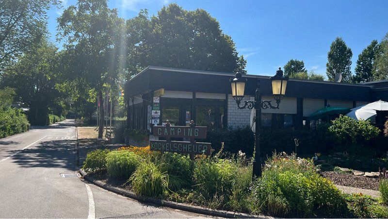
City-camping Kockelscheuer
Today's goal has been reached and we have settled in.
route de Bettembourg 22, 1899, Luxemburg, Luxemburg
49° 34' 22" N 6° 6' 32" E
49.5727800 6.1088900
• Head east. Go for 33 m.
• Continue on Route de Bettembourg. Go for 146 m.
• Turn left onto Route de Bettembourg. Go for 258 m.
• Turn left onto Route de Bettembourg (CR186). Go for 416 m.
• Turn left toward Route d'Esch/N4. Go for 405 m.
• Continue on Route d'Esch (N4). Go for 1.7 km.
• Take ramp onto A4 toward Luxembourg. Go for 1.7 km.
• Take the exit toward Bruxelles/Liège onto A6. Go for 18.2 km.
• Continue on E25/E411. Go for 42.6 km.
• Continue on E411 toward Bruxelles/Namur. Go for 124 km.
• Take exit 8 toward Louvain/Grez-Doiceau/Chaumont-Gistoux onto N25. Go for 6.1 km.
• Pass 3 roundabouts and continue on N25. Go for 11.7 km.
• Continue on Expresweg (N25) toward Bierbeek/Haasrode/Brussel/E40/Luik/Industriezone Haasrode. Go for 2.4 km.
• Take the 2nd exit from roundabout onto E40 (Autoroute Hesbignonne) toward Brussel/Leuven. Go for 17.2 km.
• Take the exit toward Antwerpen/E19 onto E40. Go for 4.6 km.
• Take the exit toward Antwerpen/Mechelen/Luchthaven Cargo onto E19. Go for 34.8 km.
• Take the exit toward Breda/Luik/Haven 1-999 onto E19/E34 (Kleine Ring). Go for 3.8 km.
• Continue on E19 (Ring Antwerpen 2) toward Ring 2/Breda/Haven. Go for 41.0 km.
• Continue on A16. Go for 10.3 km.
• Continue on A16 toward Breda-Noord/Industrieterrein Breda 0-5000/Utrecht/Rotterdam. Go for 15.0 km.
• Continue on A16 toward Dordrecht/Rotterdam. Go for 12.0 km.
• Keep right onto A16 toward Zwijndrecht/Rotterdam. Go for 9.8 km.
• Keep left onto A16 (Knooppunt Ridderkerk) toward Den Haag/Havens 200-1000. Go for 8.8 km.
• Take the exit onto A20 (Knooppunt Terbregseplein). Go for 6.5 km.
• Take the exit toward Vliegveld/Amsterdam/Den Haag onto A13 (Knooppunt Kleinpolderplein). Go for 14.0 km.
• Continue on E19 (Knooppunt Ypenburg) toward E30/Ring-Oost/Amsterdam/Utrecht/Den Haag/A4. Go for 3.1 km.
• Continue on A4. Go for 9.0 km.
• Take the exit toward Katwijk/Leiden onto N434. Go for 5.0 km.
• Take ramp toward Amsterdam/Katwijk/Leiden/A44/Afrit 9/Leiden-Zuid. Go for 1.2 km.
• Turn right onto Ommedijkseweg toward Leiden-Zuid/Bedrijventerrein Maaldrift. Go for 134 m.
• Take the 3rd exit from roundabout onto Ommedijkseweg. Go for 1.2 km.
• Continue on Rijksstraatweg. Go for 425 m.
• Turn right onto Maaldrift. Go for 735 m.
• Arrive at Maaldrift.
☍
408,0 km
(3 hrs. 58 min.)
Day
Camping Maaldrift
Maaldrift 9, 2241 BN, Wassenaar, Niederlande
52° 9' 12.7" N 4° 25' 38.9" E
52.1535400 4.4274700
• Head southwest on Maaldrift. Go for 398 m.
• Turn left onto Ammonslaantje. Go for 463 m.
• Turn right onto Deijlerweg. Go for 961 m.
• Take the 3rd exit from roundabout onto Rozenweg. Go for 147 m.
• Turn right onto Rijksstraatweg (N44). Go for 6.0 km.
• Continue on Leidsestraatweg (s101). Go for 2.0 km.
• Turn left onto Laan van Nieuw Oost-Indië. Go for 595 m.
• Continue on Laan van Nieuw-Oost-Indië. Go for 530 m.
• Continue on Laan van Nieuw Oost-Indië. Go for 405 m.
• Turn right onto Schenkkade. Go for 668 m.
• Continue on Schenkviaduct. Go for 736 m.
• Continue on Schenkstraat. Go for 160 m.
• Continue on Rijswijkseplein. Go for 192 m.
• Continue on Rijswijkseweg. Go for 164 m.
• Turn right onto Waldorpstraat. Go for 1.2 km.
• Turn right onto Calandstraat (s100). Go for 118 m.
• Continue on Vaillantlaan (s100). Go for 1.1 km.
• Enter the roundabout. Go for 96 m.
• Arrive at Vaillantplein. Your destination is on the left.
☍
15,9 km
( 22 min.)
Day
Den Haag, Niederlande
52° 4' 13.8" N 4° 18' 2.5" E
52.0704978 4.3006999
• Follow the roundabout. Go for 78 m.
• Take the 3rd exit from roundabout onto Vaillantplein (s100). Go for 42 m.
• Continue on Buitenom (s100). Go for 494 m.
• Turn right onto Noord West Buitensingel (s100). Go for 328 m.
• Continue on Koningin Emmaplein (s100). Go for 18 m.
• Continue on Waldeck Pyrmontkade (s100). Go for 1.2 km.
• Continue on Stadhouderslaan (s103). Go for 397 m.
• Turn right onto President Kennedy Laan (s200). Go for 2.4 km.
• Keep left onto Hubertusviaduct (s200) toward Wassenaar (N44)/Amsterdam (A4). Go for 4.0 km.
• Keep right. Go for 723 m.
• Continue straight ahead. Go for 74 m.
• Continue toward Rijksstraatweg/N44. Go for 101 m.
• Take ramp onto Rijksstraatweg (N44) toward Wassenaar/Leiden/Amsterdam/Duinrell. Go for 5.5 km.
• Turn left toward Rozenweg. Go for 39 m.
• Continue on Rozenweg. Go for 75 m.
• Take the 1st exit from roundabout onto Deijlerweg. Go for 977 m.
• Turn left onto Ammonslaantje. Go for 463 m.
• Turn right onto Maaldrift. Go for 394 m.
• Arrive at Maaldrift. Your destination is on the right.
☍
17,2 km
( 22 min.)
Camping Maaldrift
Maaldrift 9, 2241 BN, Wassenaar, Niederlande
52° 9' 12.7" N 4° 25' 38.9" E
52.1535400 4.4274700
• Head east on Maaldrift. Go for 739 m.
• Turn left onto Rijksstraatweg. Go for 425 m.
• Continue on Ommedijkseweg. Go for 1.1 km.
• Take the 2nd exit from roundabout onto Haagse Schouwweg. Go for 151 m.
• Continue on Haagsche Schouwbrug. Go for 50 m.
• Continue on Haagse Schouwweg. Go for 70 m.
• Take the 2nd exit from roundabout onto Haagse Schouwweg. Go for 834 m.
• Turn left onto Plesmanlaan (N206). Go for 385 m.
• Turn right and take ramp onto A44 toward Rijnsburg/Amsterdam. Go for 18.2 km.
• Continue on A4 (Knooppunt Burgerveen). Go for 6.9 km.
• Keep right onto A5 (Knooppunt de Hoek) toward Zaanstad/Haarlem. Go for 6.9 km.
• Take the exit toward Alkmaar/Haarlem onto A9. Go for 31.6 km.
• Take exit 12 toward Ring-West/Den Helder/Heiloo/Alkmaar-Centrum/N9. Go for 1.2 km.
• Take the 4th exit from Verkeersplein Kooimeer roundabout onto Heilooër Tolweg (N9) toward Egmond/Bergen/Heiloo/Den Helder. Go for 940 m.
• Continue on Heilooër Tolweg (N9) toward Ring Alkmaar/Egmond/Bergen/Den Helder. Go for 3.4 km.
• Continue on Martin Luther Kingweg (N9) toward RING Noord/Schoorl/Den Helder. Go for 2.6 km.
• Continue on Helderseweg (N9) toward Schoorl/Den Helder. Go for 12.0 km.
• Take the 1st exit from roundabout onto Rijksweg (N9) toward Den Helder/Schagen. Go for 22.9 km.
• Keep right toward Veer Texel/Havens. Go for 21 m.
• Take the 1st exit from roundabout onto N250 toward Veer Texel/Havens. Go for 2.2 km.
• Turn right onto Weststraat (N250) toward Veer Texel. Go for 428 m.
• Turn right onto Nieuwe Kerkplein. Go for 30 m.
• Continue on Willemsoord. Go for 78 m.
• Turn left onto Willemsoord. Go for 144 m.
• Turn right. Go for 50 m.
• Turn left. Go for 13 m.
• Arrive at your destination.
☍
113,3 km
(1 hrs. 25 min.)
Day
Jachthaven Willemsoord
Only transit / sightseeing
Willemsoord 47, 1781, Den Helder, Niederlande
52° 57' 45" N 4° 46' 14" E
52.9625000 4.7705556
• Head west. Go for 13 m.
• Turn right. Go for 126 m.
• Turn right toward Plein 1832. Go for 10 m.
• Turn left onto Plein 1832. Go for 102 m.
• Continue on Willemsoord. Go for 6 m.
• Turn right onto Willemsoord. Go for 23 m.
• Continue on Nieuwe Kerkplein. Go for 30 m.
• Turn left onto Weststraat (N250). Go for 428 m.
• Turn left onto Zuidstraat (N250) toward Leeuwarden/Alkmaar. Go for 2.1 km.
• Keep left toward Leeuwarden/Alkmaar. Go for 24 m.
• Take the 2nd exit from roundabout onto N250 toward Alkmaar/Leeuwarden. Go for 3.3 km.
• Turn right onto N99. Go for 364 m.
• Turn left onto N99 toward Breezand/Leeuwarden/Amsterdam/Kon. Marine Nieuwe Haven/Industrieterrein Oostoever. Go for 628 m.
• Keep right toward Anna Paulowna/Amsterdam/Leeuwarden. Go for 27 m.
• Pass 6 roundabouts and continue on Rijksstraatweg (N99). Go for 18.0 km.
• Turn left and take ramp onto A7 (Afsluitdijk) toward Leeuwarden/Groningen. Go for 29.1 km.
• Take exit 15 toward Zurich/Harlingen/Leeuwarden/N31. Go for 639 m.
• Keep left onto A31 toward Harlingen/Leeuwarden/N31. Go for 1.5 km.
• Continue on N31. Go for 10.4 km.
• Keep left onto A31 toward Franeker. Go for 18.6 km.
• Continue on N31. Go for 33.5 km.
• Take ramp onto A7 toward Groningen. Go for 30.8 km.
• Take exit 36 toward Ring-West/Groningen-West/Zuidhorn/Winsum onto N370. Go for 5.2 km.
• Take ramp onto Plataanlaan (N370) toward Ring Groningen/Bedum/Winsum. Go for 28.2 km.
• Take ramp. Go for 1.3 km.
• Turn right onto Greedeweg. Go for 889 m.
• Turn left onto D. Luddesweg. Go for 2.1 km.
• Turn left onto Dijkweg. Go for 530 m.
• Turn slightly right onto Dijkweg. Go for 107 m.
• Turn right onto Dijkweg. Go for 1.0 km.
• Arrive at Dijkweg.
☍
189,2 km
(2 hrs. 13 min.)
Eemshaven, Niederlande
9979 Eemshaven, Niederlande
53° 26' 18.9" N 6° 50' 7.8" E
53.4385887 6.8354937
• Head southwest on Dijkweg. Go for 2.6 km.
• Turn right onto Klaas Wiersumsweg. Go for 1.1 km.
• Turn right onto Kwelderweg. Go for 271 m.
• Turn left onto Westereemsweg. Go for 738 m.
• Turn left onto Westlob. Go for 843 m.
• Take the 2nd exit from roundabout onto Borkumkade. Go for 2.2 km.
• Turn right onto Borkumkade. Go for 446 m.
• Turn right onto Borkumkade. Go for 105 m.
• Take the Eemshaven-Borkum Ferry. Stay on for 19.3 km.
• Head west on Reedestraße. Go for 35 m.
• Turn right onto Reedestraße. Go for 4.7 km.
• Turn right onto Ostfriesenstraße. Go for 1.4 km.
• Turn left onto Barbaraweg. Go for 958 m.
• Turn slightly left onto Hindenburgstraße. Go for 71 m.
• Turn left. Go for 28 m.
• Arrive at your destination on the right.
☍
34,8 km
(1 hrs. 30 min.)
Day
Insel-Camping-Borkum, Hindenburgstraße, Borkum, Deutschland
Hindenburgstraße 114, 26757 Borkum, Deutschland
53° 35' 37" N 6° 40' 33.6" E
53.5936017 6.6759881
• Head toward Hindenburgstraße. Go for 28 m.
• Turn left onto Hindenburgstraße. Go for 167 m.
• Turn left onto Richthofenstraße. Go for 641 m.
• Turn right onto Blumenstraße. Go for 72 m.
• Arrive at Blumenstraße. Your destination is on the right.
☍
0,9 km
( 3 min.)
Day
Borkum, Deutschland
53° 35' 15.6" N 6° 40' 13.2" E
53.5876636 6.6703248
• Head south on Blumenstraße. Go for 72 m.
• Turn left onto Blumenstraße. Go for 641 m.
• Turn right onto Hindenburgstraße. Go for 167 m.
• Turn right. Go for 28 m.
• Arrive at your destination on the right.
☍
0,9 km
( 3 min.)
Day
Insel-Camping-Borkum, Hindenburgstraße, Borkum, Deutschland
Hindenburgstraße 114, 26757 Borkum, Deutschland
53° 35' 37" N 6° 40' 33.6" E
53.5936017 6.6759881
• Head toward Hindenburgstraße. Go for 28 m.
• Turn right onto Hindenburgstraße. Go for 71 m.
• Turn slightly right onto Barbaraweg. Go for 958 m.
• Turn right onto Ostfriesenstraße. Go for 1.4 km.
• Turn left onto Reedestraße. Go for 3.9 km.
• Turn right onto Am Neuen Hafen. Go for 307 m.
• Turn left onto Juister Strate. Go for 513 m.
• Continue on Reedestraße. Go for 70 m.
• Turn slightly left onto Reedestraße. Go for 106 m.
• Turn left onto Reedestraße. Go for 15 m.
• Turn right onto Reedestraße. Go for 35 m.
• Take the Borkum-Eemshaven Ferry. Stay on for 19.3 km.
• Head northwest on Borkumkade. Go for 105 m.
• Turn left onto Borkumkade. Go for 446 m.
• Turn left onto Borkumkade. Go for 2.2 km.
• Take the 1st exit from roundabout onto Westlob. Go for 876 m.
• Turn right onto Westereemsweg. Go for 738 m.
• Turn left onto Kwelderweg. Go for 482 m.
• Take the 2nd exit from roundabout onto Kwelderweg. Go for 3.0 km.
• Take the 1st exit from roundabout onto Kwelderweg (N33). Go for 1.5 km.
• Take the 1st exit from roundabout onto Oostpolder (N33). Go for 7.6 km.
• Continue on N33. Go for 7.7 km.
• Turn left onto N362 toward Industrieterrein Delfzijl. Go for 5.2 km.
• Take the 1st exit from roundabout onto N362. Go for 3.6 km.
• Pass 2 roundabouts and continue on Oude Rijksweg (N362). Go for 9.5 km.
• Take the 1st exit from roundabout onto A7 toward Winschoten/Nieuweschans/Industrieterrein Eextahaven. Go for 20.3 km.
• Continue on A280. Go for 4.3 km.
• Take the left exit toward Emden/Leer/Oldenburg/Weener onto A31. Go for 20.7 km.
• Take exit 9 toward Norddeich/Emden/Veenhusen onto A31. Go for 23.4 km.
• Take exit 5 toward Emden-Ost/Häfen-Ost/Gewerbegebiet-Ost onto B210. Go for 2.5 km.
• Turn left onto Petkumer Straße (L2) toward Oldersum/Borkum/Häfen-Ost/Gewerbegebiet Ost. Go for 151 m.
• Turn right onto Südumgehungsstraße. Go for 578 m.
• Continue on Am Tonnenhof. Go for 709 m.
• Continue on Nesserlander Straße. Go for 1.9 km.
• Turn left onto Am Seemannsheim. Go for 34 m.
• Turn right. Go for 31 m.
• Turn left toward Am Außenhafen. Go for 144 m.
• Turn left onto Am Außenhafen. Go for 13 m.
• Continue on An der Nesserlander Schleuse. Go for 204 m.
• Turn right. Go for 934 m.
• Arrive at your destination.
☍
145,6 km
(2 hrs. 44 min.)
Emder Hafen, Emden, Deutschland
Emder Hafen, 26723 Emden, Deutschland
53° 20' 8" N 7° 11' 1" E
53.3355556 7.1836111
• Head toward An der Nesserlander Schleuse. Go for 934 m.
• Turn left onto An der Nesserlander Schleuse. Go for 204 m.
• Continue on Am Außenhafen. Go for 13 m.
• Turn right toward Am Seemannsheim. Go for 175 m.
• Turn left onto Am Seemannsheim. Go for 34 m.
• Turn right onto Nesserlander Straße. Go for 1.8 km.
• Continue on Nesserlander Straße. Go for 145 m.
• Continue on Am Tonnenhof. Go for 709 m.
• Continue on Südumgehungsstraße. Go for 578 m.
• Turn left onto Petkumer Straße (L2). Go for 119 m.
• Turn right onto B210. Go for 1.5 km.
• Take ramp onto A31 toward Oberhausen/Aurich/Leer. Go for 23.3 km.
• Take the left exit toward Oldenburg/Leer-Ost onto A28. Go for 32.6 km.
• Take exit 6 toward Westerstede/Varel/Neuenburg/Hüllstede. Go for 253 m.
• Turn right onto Ammerlandallee (L815). Go for 2.7 km.
• Turn right onto Zum Hullen (L820). Go for 7.7 km.
• Turn left onto Wiefelsteder Straße (L820). Go for 7.5 km.
• Take the 2nd exit from roundabout onto Jaderberger Straße (L862) toward Jaderberg. Go for 10.0 km.
• Turn right onto Bundesstraße (B437). Go for 13.4 km.
• Take ramp onto B212 toward Bremen/A27/Cuxhaven/Nordenham/Rodenkirchen. Go for 4.0 km.
• Take ramp onto B437 toward Bremen/A27/Cuxhaven/Stotel. Go for 9.9 km.
• Take ramp onto A27 toward Cuxhaven/Bremerhaven. Go for 48.1 km.
• Take the 1st exit from roundabout onto B73 toward Hamburg/Stade/Otterndorf/Altenbruch. Go for 2.8 km.
• Turn left toward Altenbruch. Go for 35 m.
• Continue on Alter Weg. Go for 729 m.
• Turn left toward Am Altenbrucher Markt. Go for 33 m.
• Continue on Altenbrucher Bahnhofstraße. Go for 610 m.
• Turn right onto Wehldorfer Straße (K4). Go for 2.3 km.
• Continue on Wehldorf (K4). Go for 2.4 km.
• Continue on Müggendorfer Straße (K4). Go for 2.2 km.
• Turn left onto Westerwischer Weg. Go for 373 m.
• Continue on Westerwischer Weg. Go for 706 m.
• Turn right onto Am Campingplatz. Go for 364 m.
• Turn left onto Am Campingplatz. Go for 109 m.
• Arrive at Am Campingplatz. Your destination is on the right.
☍
178,4 km
(2 hrs. 16 min.)
Campingplatz See Achtern Diek, Am Campingplatz, Otterndorf, Deutschland
Am Campingpl. 3, 21762 Otterndorf, Deutschland
53° 49' 33" N 8° 52' 39.9" E
53.8258276 8.8777415
• Head northeast on Am Campingplatz.
• Arrive at Am Campingplatz. Your destination is on the right.
☍
Distance not available
(Duration not available)
Day
Day
Day
Campingplatz See Achtern Diek, Am Campingplatz, Otterndorf, Deutschland
Am Campingpl. 3, 21762 Otterndorf, Deutschland
53° 49' 33" N 8° 52' 39.9" E
53.8258276 8.8777415
• Head southwest on Am Campingplatz. Go for 109 m.
• Turn right onto Am Campingplatz. Go for 364 m.
• Turn left onto Westerwischer Weg. Go for 706 m.
• Continue on Westerwischer Weg. Go for 373 m.
• Turn left onto Müggendorfer Straße (K4). Go for 525 m.
• Turn left onto Norderteiler Weg. Go for 1.6 km.
• Turn right onto Deichstraße. Go for 638 m.
• Turn slightly right onto Schleuse. Go for 302 m.
• Continue on Schleusenstraße. Go for 1.2 km.
• Continue on Schillerstraße. Go for 117 m.
• Turn right onto Stephanstraße. Go for 245 m.
• Turn left onto Schulstraße. Go for 228 m.
• Continue on Rosenstraße. Go for 308 m.
• Turn left onto Stader Straße. Go for 376 m.
• Continue on Stader Landstraße. Go for 675 m.
• Turn left onto Stader Landstraße (B73). Go for 38.7 km.
• Take the 2nd exit from roundabout onto Hauptstraße (B73) toward Hamburg/Stade. Go for 14.7 km.
• Keep left onto A26. Go for 23.5 km.
• Take the right exit. Go for 285 m.
• Turn left onto Bahnhofstraße (L235). Go for 1.5 km.
• Turn left onto Achtern Bahnhof toward Neu Wulmstorf/Gewerbegebiet Wulmstorfer Wiesen. Go for 96 m.
• Take the 3rd exit from Wulmstorfer Wiesen roundabout onto Wulmstorfer Wiesen. Go for 367 m.
• Take the 1st exit from roundabout. Go for 342 m.
• Continue on Bahnhofstraße. Go for 142 m.
• Take the 2nd exit from roundabout onto Bahnhofstraße. Go for 1.1 km.
• Turn left onto Hauptstraße (B73). Go for 13.6 km.
• Turn left onto Hannoversche Brücke toward Wilhelmsburg. Go for 917 m.
• Turn right onto Neuländer Straße. Go for 1.9 km.
• Take ramp onto A1 toward Lübeck/Berlin/HH-Centrum. Go for 5.1 km.
• Take exit 36 toward Lübeck/Berlin/Hamburg-Südost onto A1. Go for 62.7 km.
• Take exit 22 toward Stockelsdorf. Go for 271 m.
• Turn left onto Stockelsdorfer Straße (K26). Go for 539 m.
• Continue on Krempelsdorfer Allee (L332) toward B206/Kiel/Itzehoe/Bad Segeberg. Go for 564 m.
• Turn right onto Ahrensböker Straße. Go for 1.4 km.
• Turn right onto Ahrensböker Straße. Go for 913 m.
• Turn right onto Ahrensböker Straße (L184). Go for 15.1 km.
• Turn left onto Ahrensböker Straße (L306). Go for 3.5 km.
• Continue on Dorfstraße (L306). Go for 1.0 km.
• Turn left onto Plöner Straße (L306). Go for 2.7 km.
• Continue on Dorfstraße (L306). Go for 670 m.
• Turn left onto Brüggkamp (L306). Go for 473 m.
• Continue on L306. Go for 2.1 km.
• Continue on Brackrade (L306). Go for 628 m.
• Continue on L306. Go for 267 m.
• Continue on Alte Salzstraße (L306). Go for 3.4 km.
• Turn left onto Augstfelde. Go for 1.8 km.
• Turn right onto Hof Augustfelde. Go for 11 m.
• Arrive at Hof Augustfelde. Your destination is on the left.
☍
208,1 km
(3 hrs. 11 min.)
Campingpark Augstfelde
Augstfelde 1, 24306, Bösdorf bei Plön, Deutschland
54° 7' 43.4" N 10° 27' 18" E
54.1287300 10.4550000
• Head toward Augstfelde on Hof Augustfelde. Go for 11 m.
• Turn left onto Augstfelde. Go for 1.8 km.
• Turn left onto Alte Salzstraße (L306). Go for 460 m.
• Continue on Kleinmühlen (L306). Go for 470 m.
• Turn right onto B76. Go for 21.1 km.
• Turn left and take ramp onto A1 toward Lübeck/Scharbeutz/Lübeck-Travemünde. Go for 12.0 km.
• Take exit 18 toward Ratekau/Niendorf/Ostsee/Timmendorfer Strand. Go for 395 m.
• Turn left onto L181 toward Timmendorfer Strand/Hemmelsdorf/Niendorf/Ostsee. Go for 390 m.
• Turn right onto K15. Go for 1.4 km.
• Continue on Seekamp (K15). Go for 764 m.
• Continue on Offendorfer Straße (K15). Go for 903 m.
• Turn right onto Sonnenbergsredder (K20). Go for 743 m.
• Continue on K20. Go for 1.4 km.
• Turn left onto Waldhusener Weg (K20). Go for 1.4 km.
• Turn left onto Travemünder Landstraße (K20). Go for 2.8 km.
• Turn left onto Ivendorfer Landstraße (K2). Go for 1.2 km.
• Turn left onto Frankenkrogweg. Go for 78 m.
• Arrive at Frankenkrogweg. Your destination is on the right.
☍
47,4 km
( 42 min.)
Day
Campingplatz Travemünde - Ivendorf, Frankenkrogweg, Lübeck, Deutschland
Frankenkrogweg 2-4, 23570 Lübeck, Deutschland
53° 56' 30.4" N 10° 50' 37.8" E
53.9417828 10.8438289
• Head toward Hollbeck on Frankenkrogweg. Go for 410 m.
• Turn left onto Ovendorfer Straße (K10). Go for 320 m.
• Turn right onto Ivendorfer Landstraße (K2). Go for 782 m.
• Turn right onto Travemünder Landstraße (K20). Go for 2.8 km.
• Turn right onto Solmitzstraße (K20). Go for 562 m.
• Take ramp onto Travemünder Landstraße (B75) toward Hamburg/A1/Puttgarden/Lübeck. Go for 1.3 km.
• Take ramp onto Travemünder Landstraße (B75/B104) toward Rostock/Schwerin/Lübeck-Zentrum. Go for 3.3 km.
• Take ramp onto B104 toward Rostock/Schwerin/Schlutup Fähre/Israelsdorf/Gothmund. Go for 20.0 km.
• Continue on B104 toward Rostock/A20/Lübeck/Schwerin/Gadebusch. Go for 1.2 km.
• Take ramp onto A20 toward Rostock. Go for 91.2 km.
• Take exit 17 toward Rostock-Überseehafen/Rostock-Ost/B105 onto A19. Go for 12.3 km.
• Take exit 5 toward Hohe Düne/Rostock-Nord/Graal-Müritz/GVZ. Go for 280 m.
• Turn left onto Neu Hinrichsdorf (L22) toward Graal-Müritz/Hohe Düne. Go for 3.4 km.
• Turn left onto Max-Garthe-Straße (L22). Go for 4.3 km.
• Take the 2nd exit from roundabout onto L22. Go for 524 m.
• Continue on Graal-Müritzer-Straße (L22). Go for 4.2 km.
• Continue on L22. Go for 2.4 km.
• Continue on Torfbrücke (L22). Go for 287 m.
• Continue on L22. Go for 67 m.
• Turn left onto Wiedortschneise. Go for 873 m.
• Turn right onto Wiedortschneise. Go for 131 m.
• Arrive at Wiedortschneise. Your destination is on the left.
☍
150,6 km
(1 hrs. 39 min.)
Day
Ostseecamp Rostocker Heide
Wiedortschneise 1, 18181, Graal-Müritz, Deutschland
54° 14' 40.6" N 12° 12' 42.9" E
54.2446200 12.2119300
• Head south on Wiedortschneise. Go for 131 m.
• Turn left onto Wiedortschneise. Go for 873 m.
• Turn left onto Rostocker Straße (L22). Go for 1.1 km.
• Continue on Lange Straße (L22). Go for 513 m.
• Continue on Bahnhofstraße (L22). Go for 574 m.
• Continue on Birkenallee (L22). Go for 515 m.
• Turn right onto Ribnitzer Straße (L22). Go for 2.1 km.
• Continue on L22. Go for 1.3 km.
• Continue on Müritzer Straße-Neuheide (L22). Go for 1.2 km.
• Continue on Müritzer Straße (L22). Go for 305 m.
• Continue on Müritzer Straße-Neuheide (L22). Go for 368 m.
• Continue on Zum Wallbach (L22). Go for 2.1 km.
• Continue on Mecklenburger Straße (L22). Go for 4.4 km.
• Turn right onto L22. Go for 790 m.
• Turn left onto B105 toward A20/Stralsund/Ribnitz-Damgarten/Damgarten/Krankenhaus. Go for 47.1 km.
• Take left ramp onto B96 toward Sassnitz/Fähre/Insel Rügen/Stralsund-Altstadt. Go for 1.9 km.
• Keep left onto B96. Go for 5.3 km.
• Take ramp toward Altefähr/Rambin. Go for 511 m.
• Turn right onto L296 toward Altefähr. Go for 385 m.
• Turn left. Go for 489 m.
• Turn right toward Bahnhofstraße. Go for 431 m.
• Continue on Bahnhofstraße. Go for 646 m.
• Turn slightly right onto Bahnhofstraße. Go for 63 m.
• Turn slightly left onto Barnkevitzer Weg. Go for 98 m.
• Turn left onto Am Kurpark. Go for 273 m.
• Arrive at Am Kurpark. Your destination is on the left.
☍
73,4 km
(1 hrs. 2 min.)
Day
Day
Sund Camp Altefähr, Am Kurpark, Altefähr, Deutschland
Am Kurpark 1, 18573 Altefähr, Deutschland
54° 19' 55.3" N 13° 7' 21.2" E
54.3320168 13.1225575
• Head toward Sonnengarten on Am Kurpark. Go for 273 m.
• Turn right onto Barnkevitzer Weg. Go for 98 m.
• Turn right onto Klingenberg. Go for 31 m.
• Continue on Am Fährberg. Go for 42 m.
• Turn left onto Bahnhofstraße. Go for 1.1 km.
• Turn left toward B96. Go for 489 m.
• Take ramp onto B96. Go for 32.6 km.
• Take left ramp onto A20 toward Berlin/Stettin/Stettin (Szczecin)/Neubrandenburg. Go for 78.8 km.
• Take exit 33 toward Friedland i.M./Neustrelitz/Woldegk. Go for 294 m.
• Turn right onto L281 toward Neustrelitz/Woldegk/Holzendorf. Go for 10.0 km.
• Take the 2nd exit from roundabout onto Neubrandenburger Chaussee (B104/B198) toward Pasewalk/Prenzlau. Go for 2.7 km.
• Take the 1st exit from roundabout onto Prenzlauer Chaussee (B198) toward Prenzlau. Go for 25.3 km.
• Turn right onto Baustraße (B109/B198) toward Berlin/A11/Angermünde/Gewerbegebiet Schafgrund. Go for 330 m.
• Continue on Baustraße (B198) toward Berlin/A11/Stettin (Szczecin)/Angermünde/Schwedt/Oder/Gewerbegebiet Schafgrund. Go for 459 m.
• Turn right onto Am Steintor. Go for 36 m.
• Turn slightly left onto Friedhofstraße. Go for 90 m.
• Turn right onto Seeweg. Go for 280 m.
• Take the 2nd exit from Uckerpromenade roundabout onto Uckerpromenade. Go for 1.7 km.
• Turn left. Go for 129 m.
• Turn right. Go for 61 m.
• Turn slightly right. Go for 29 m.
• Turn slightly right. Go for 101 m.
• Turn slightly left. Go for 69 m.
• Turn right. Go for 45 m.
• Arrive at your destination on the left.
☍
155,1 km
(1 hrs. 39 min.)
Day
Day
Day
Campingplatz Sonnenkap
Uckerpromenade 85, 17291, Prenzlau, Deutschland
53° 17' 32.3" N 13° 52' 17.5" E
53.2923183 13.8715407
• Head south. Go for 45 m.
• Turn left. Go for 21 m.
• Turn slightly right. Go for 227 m.
• Turn slightly right. Go for 31 m.
• Turn left toward Uckerpromenade. Go for 129 m.
• Turn right onto Uckerpromenade. Go for 1.6 km.
• Take the 2nd exit from Uckerpromenade roundabout onto Seeweg. Go for 304 m.
• Turn left onto Friedhofstraße. Go for 90 m.
• Turn slightly right onto Am Steintor. Go for 36 m.
• Turn right onto Baustraße (B198). Go for 1.4 km.
• Continue on Angermünder Straße (B198) toward A11/Berlin/Angermünde. Go for 11.2 km.
• Turn right and take ramp onto A11 toward Berlin. Go for 77.8 km.
• Take the exit toward Dresden/Frankfurt (Oder) onto A10 (Berliner Ring). Go for 54.1 km.
• Take exit 11 toward Dresden/Cottbus onto A13. Go for 62.8 km.
• Take exit 10 toward Chemnitz/Dresden onto A13. Go for 88.2 km.
• Take exit 23 toward Chemnitz/Prag/Praha/Dresden/Flughafen onto A4. Go for 3.9 km.
• Take exit 81A toward Gewerbegebiet VW-Manufaktur/Dresden-Hellerau/Dresden-Zentrum. Go for 274 m.
• Turn right onto Radeburger Straße (B170) toward Dresden-Zentrum. Go for 4.5 km.
• Continue on Großenhainer Straße (B170) toward Pirna/Zentrum. Go for 468 m.
• Turn right onto Antonstraße (B6). Go for 1.2 km.
• Continue on Könneritzstraße (B173) toward Freiberg. Go for 2.2 km.
• Continue on Wiener Platz. Go for 442 m.
• Continue on Wiener Straße. Go for 187 m.
• Keep left onto Wiener Straße toward Pirna/Zoo. Go for 500 m.
• Continue on Wiener Straße. Go for 347 m.
• Continue on Richard-Strauss-Platz. Go for 33 m.
• Turn right onto Richard-Strauss-Platz. Go for 30 m.
• Continue on Gerhart-Hauptmann-Straße. Go for 170 m.
• Turn slightly left onto Teplitzer Straße toward A17/Pirna/Strehlen. Go for 1.4 km.
• Turn right onto Gostritzer Straße. Go for 22 m.
• Turn left onto Gostritzer Straße. Go for 892 m.
• Turn right onto Boderitzer Straße. Go for 551 m.
• Turn right. Go for 69 m.
• Arrive at your destination on the left.
☍
315,4 km
(3 hrs. 3 min.)
Day
Campingplatz Dresden-Mockritz, Boderitzer Straße, Dresden, Deutschland
Boderitzer Str. 30, 01217 Dresden, Deutschland
51° 0' 52.3" N 13° 44' 50.6" E
51.0145155 13.7473981
• Head toward Boderitzer Straße. Go for 48 m.
• Turn right onto Boderitzer Straße. Go for 428 m.
• Turn right onto Babisnauer Straße. Go for 215 m.
• Continue on Altmockritz. Go for 130 m.
• Continue on Münzmeisterstraße. Go for 425 m.
• Turn left onto Südhöhe. Go for 816 m.
• Continue on Kohlenstraße. Go for 62 m.
• Turn left and take ramp onto Innsbrucker Straße (B170) toward A17/Dippoldiswalde. Go for 1.6 km.
• Turn right and take ramp onto A17 toward Görlitz/Chemnitz/Berlin. Go for 12.1 km.
• Take the left exit toward Chemnitz/Leipzig onto A4. Go for 62.7 km.
• Take exit 68 toward Hof/Zwickau/Chemnitz-Rottluff onto A72. Go for 107 km.
• Take the left exit toward München/Nürnberg/Bayreuth/Flughafen Hof onto A9. Go for 123 km.
• Take exit 52 toward Heilbronn/N.-Hafen onto A6. Go for 79.6 km.
• Take exit 48 toward Füssen/Ulm/Feuchtwangen-West onto A7. Go for 150 km.
• Take exit 128 toward Bregenz/Lindau onto A96. Go for 64.2 km.
• Continue on A14 (Rheintal Autobahn). Go for 22.8 km.
• Take exit 23 toward Diepoldsau/Hohenems. Go for 743 m.
• Take the 2nd exit from roundabout onto Diepoldsauer Straße (L46) toward Hohenems. Go for 214 m.
• Turn right onto Lustenauer Straße (L203). Go for 905 m.
• Turn right onto Barnabas-Fink-Straße. Go for 56 m.
• Arrive at Barnabas-Fink-Straße. Your destination is on the right.
☍
626,8 km
(5 hrs. 36 min.)
Day
Day
China-Restaurant Bambusgarten, Rheinhofstraße, Hohenems, Österreich
Rheinhofstraße 3, 6845 Hohenems, Österreich
47° 22' 2.9" N 9° 40' 14.7" E
47.3674833 9.6707606
• Head east on Barnabas-Fink-Straße. Go for 56 m.
• Turn left onto Lustenauer Straße (L203). Go for 861 m.
• Turn right onto Schweizer Straße (L46). Go for 1.2 km.
• Turn left onto Radetzkystraße (L190) toward Dornbirn. Go for 4.1 km.
• Turn right onto Bachmähdle. Go for 103 m.
• Turn left onto Bachmähdle. Go for 735 m.
• Turn left onto Badgasse. Go for 13 m.
• Turn right onto Bachmähdle. Go for 473 m.
• Turn left onto Haslachgasse. Go for 182 m.
• Turn right onto Mühlebacherstraße. Go for 44 m.
• Continue on Haldengasse. Go for 775 m.
• Continue on Vordere Achmühlerstraße. Go for 143 m.
• Turn right onto Gütle. Go for 656 m.
• Arrive at Gütlestraße. Your destination is on the left.
☍
9,4 km
( 16 min.)
Camping Dornbirn, Gütlestraße, Dornbirn, Österreich
Gütlestraße 15, 6850 Dornbirn, Österreich
47° 23' 57.4" N 9° 45' 25.3" E
47.3992734 9.7570268
• Head toward In der Enz on Gütlestraße. Go for 656 m.
• Turn right onto Vordere Achmühlerstraße. Go for 679 m.
• Turn left onto Sägerstraße. Go for 247 m.
• Turn left onto Stadtstraße (L190). Go for 237 m.
• Turn right onto Lustenauer Straße (L204) toward Innsbruck/Bregenz/Lustenau/B204/Schweiz/Krankenhaus. Go for 2.6 km.
• Pass 4 roundabouts and continue on Dornbirner Straße (L204). Go for 3.9 km.
• Take the 2nd exit from roundabout onto Grindelstraße (L203) toward St. Gallen/Industrie Nord. Go for 1.8 km.
• Turn left onto Lustenauer Straße (L204) toward St. Gallen/Au. Go for 385 m.
• Continue on Zollstrasse (435). Go for 298 m.
• Take the 1st exit from roundabout onto A13 toward St. Gallen/St. Margrethen. Go for 2.9 km.
• Continue on A1 toward Rheineck. Go for 116 km.
• Take the exit toward Bern/Basel/Dietikon onto A1 (Limmattaler Kreuz). Go for 16.4 km.
• Continue on A1 (Verzweigung Birrfeld) toward Bern/Aarau/Mägenwil. Go for 40.6 km.
• Continue on A1 (Härkingen) toward E25/Lausanne/Bern/Biel/Bienne/Oensingen. Go for 24.6 km.
• Take exit 40 toward Kriegstetten/Biberist/Gerlafingen. Go for 368 m.
• Continue on Gerlafingerstrasse. Go for 135 m.
• Continue on Kriegstettenstrasse. Go for 1.1 km.
• Arrive at Kriegstettenstrasse. Your destination is on the right.
☍
212,3 km
(2 hrs. 17 min.)
Day
Gerlafingen, Schweiz
47° 10' 14.6" N 7° 34' 23.3" E
47.1707295 7.5731416