Second part of the High Pyrenees with the Basque Country. A trip that continues our trip from 2023, which we ended in Cirque Garvernie due to bad weather. This is described on https://www.frankreich-in-wort-und-bild.de/wohnmobiltouren/wohnmobilreise-in-die-hoch-pyren%C3%A4en-sommer-2023-seite-1/
Now we're going back to Cirque de Gavernie on this trip to continue the trip there.
Another trip from the Mediterranean to Mont Louis, just before Andorra, in the Pyrenees is described here: https://www.frankreich-in-wort-und-bild.de/wohnmobil-touren/s%C3%BCdfrankreich-okzitanien-2/
Day
Robion
Arrival to Gavernie via motorway on 22.6.2024
Vaucluse, Provence-Alpes-Côte d'Azur, Frankreich
43° 50' 38.8" N 5° 6' 44" E
43.8441157 5.1122150
• Head toward Avenue Frédéric Mistral on Place de l'Église. Go for 15 m.
• Turn left onto Place de l'Église. Go for 467 m.
• Continue on Rue Oscar Roulet. Go for 75 m.
• Take the 2nd exit from roundabout onto Avenue de la Gare (D31). Go for 152 m.
• Pass 2 roundabouts and continue on Lieu-dit Le Plan de Robion (D31). Go for 2.0 km.
• Continue on Route de L'Isle-sur-la-Sorgue (D31). Go for 1.7 km.
• Take the 3rd exit from roundabout onto Chemin de Romieu (D900). Go for 1.3 km.
• Take the 3rd exit from roundabout onto Chemin de Romieu (D900) toward A7/Avignon. Go for 2.2 km.
• Take the 4th exit from roundabout onto Chemin de Romieu (D900) toward A7/Lyon/Avignon/Le Thor/Caumont. Go for 2.8 km.
• Pass 2 roundabouts and continue on Route de Marseille (N7). Go for 10.2 km.
• Take the 3rd exit from roundabout onto Route de Marseille (N7) toward Avignon. Go for 2.1 km.
• Take the 2nd exit from roundabout onto Route de Marseille (N7) toward Avignon. Go for 2.7 km.
• Take the 2nd exit from roundabout onto Avenue Pierre Semard (D907) toward N7/Avignon-Centre. Go for 1.3 km.
• Keep left onto Avenue Pierre Semard toward Centre Ville. Go for 369 m.
• Pass 3 roundabouts and continue on Avenue Pierre Semard. Go for 1.5 km.
• Turn left onto Boulevard Saint-Michel (N270). Go for 524 m.
• Continue on Boulevard Saint-Roch (N570). Go for 890 m.
• Continue toward A9/Nîmes/Alès/Villeneuve lès Avignon/Les Angles/Bagnols S/Cèze. Go for 155 m.
• Continue on Pont de l'Europe. Go for 4.7 km.
• Take the 3rd exit from roundabout onto N100 toward A9/Alès/Rochefort/Remoulins. Go for 1.1 km.
• Take the 2nd exit from roundabout onto N100 toward A9/Nîmes/Alès/Remoulins/Uzès. Go for 4.4 km.
• Pass 3 roundabouts and continue on N100. Go for 7.9 km.
• Take the 4th exit from roundabout onto A9 (La Languedocienne) toward Montpellier. Go for 165 km.
• Take the exit toward Toulouse/Carcassonne onto A61 (Autoroute des Deux Mers). Go for 137 km.
• Keep left onto A620 toward A614/Le Palays/Toulouse-Centre/Aéroport Blagnac/Tarbes. Go for 8.7 km.
• Take the exit toward Foix/Tarbes/Lourdes/St Sébastien onto A64 (La Pyrénéenne). Go for 150 km.
• Take exit 12 toward Lourdes/Aéroport Ossun. Go for 746 m.
• Take the 4th exit from Rond-Point Morane-Saulnier roundabout onto N21 toward Lourdes. Go for 15.4 km.
• Take the 2nd exit from Rond-Point de l'Europe roundabout onto Boulevard du Centenaire (D821) toward Bagnères de B./Argelès-G./Anclades/Centre Ville/La Grotte. Go for 1.1 km.
• Keep left onto Boulevard du Centenaire (D821). Go for 2.8 km.
• Pass 2 roundabouts and continue on D821. Go for 10.6 km.
• Take the 3rd exit from roundabout onto Chemin de Pouey Castet (D100). Go for 392 m.
• Keep right onto D913. Go for 261 m.
• Continue on Lieu-dit Bastillac (D913). Go for 79 m.
• Continue on D913. Go for 1.8 km.
• Continue on Rue du Sailhet (D913). Go for 751 m.
• Continue on D913. Go for 2.3 km.
• Continue on Lieu-dit La Lanne (D913). Go for 108 m.
• Continue on Rue de Couscouillet (D913). Go for 212 m.
• Continue on D913. Go for 925 m.
• Take the 2nd exit from roundabout onto D921. Go for 11.0 km.
• Turn right onto Avenue de Saint-Sauveur (D921). Go for 161 m.
• Turn left onto Rue de la Poste. Go for 40 m.
• Arrive at Rue de la Poste. Your destination is on the right.
☍
557,8 km
(5 hrs. 23 min.)
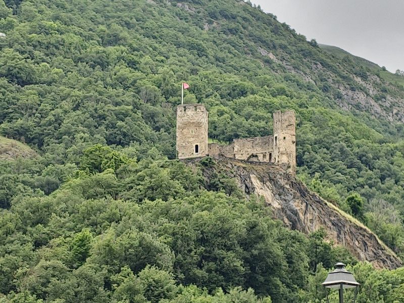
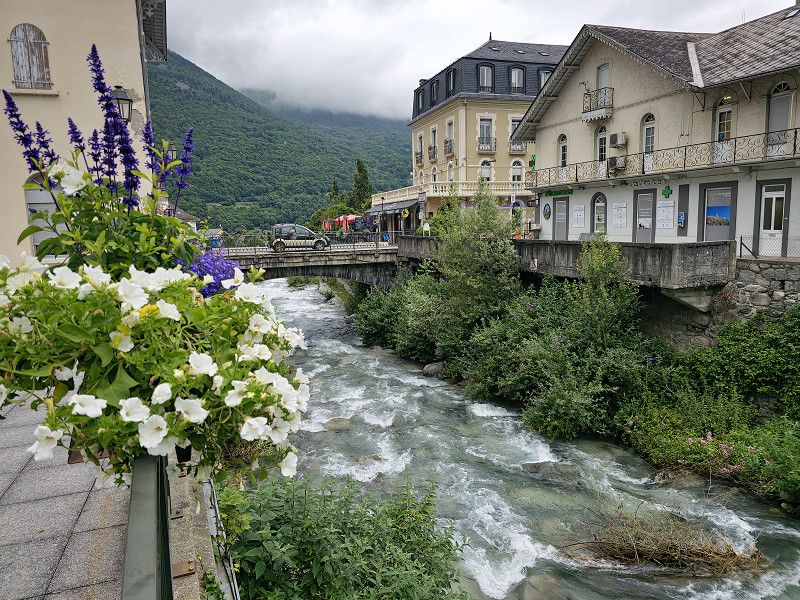
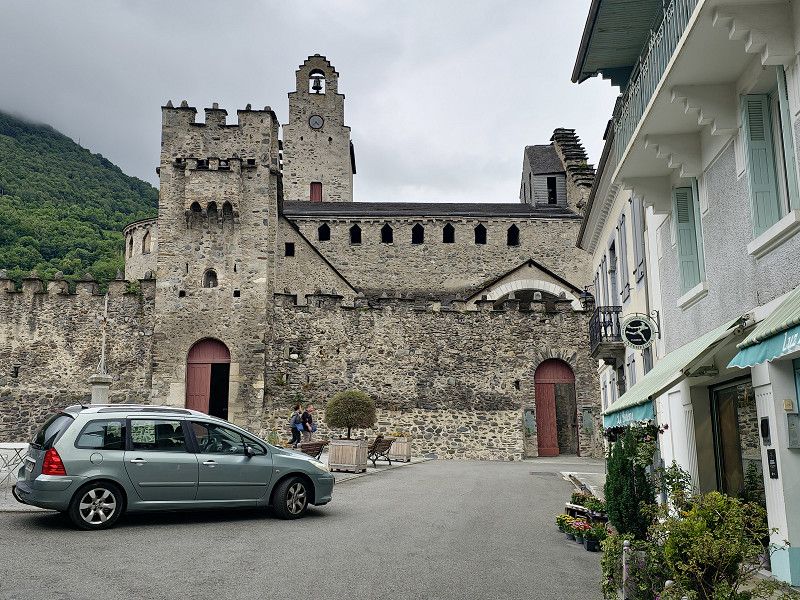
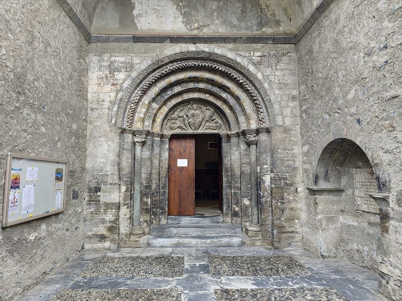
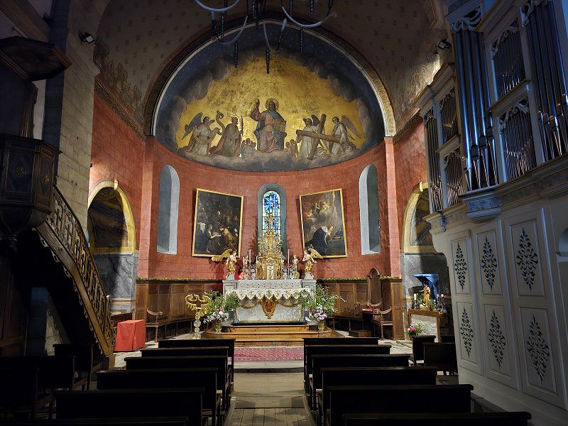
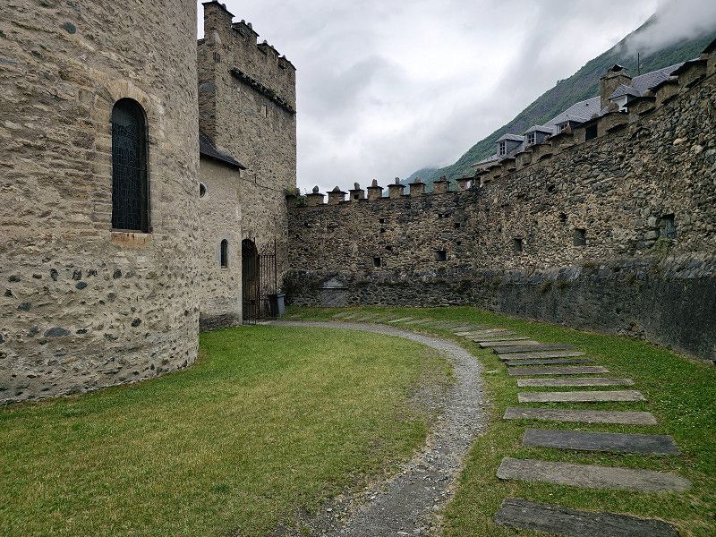
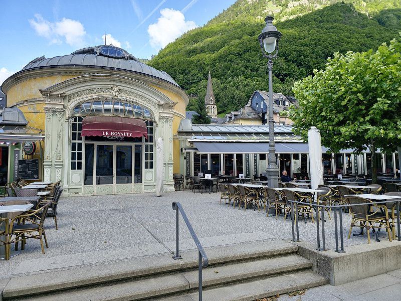
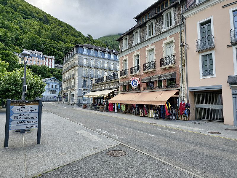
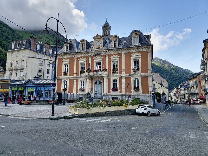
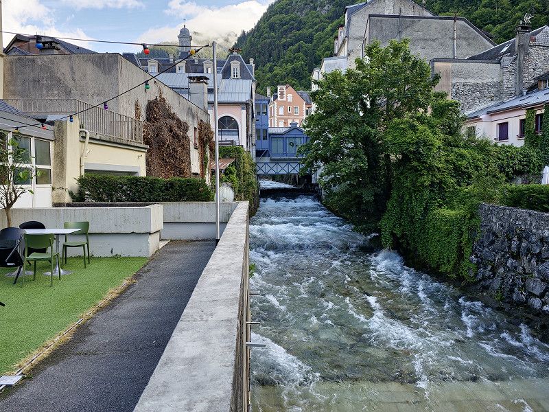
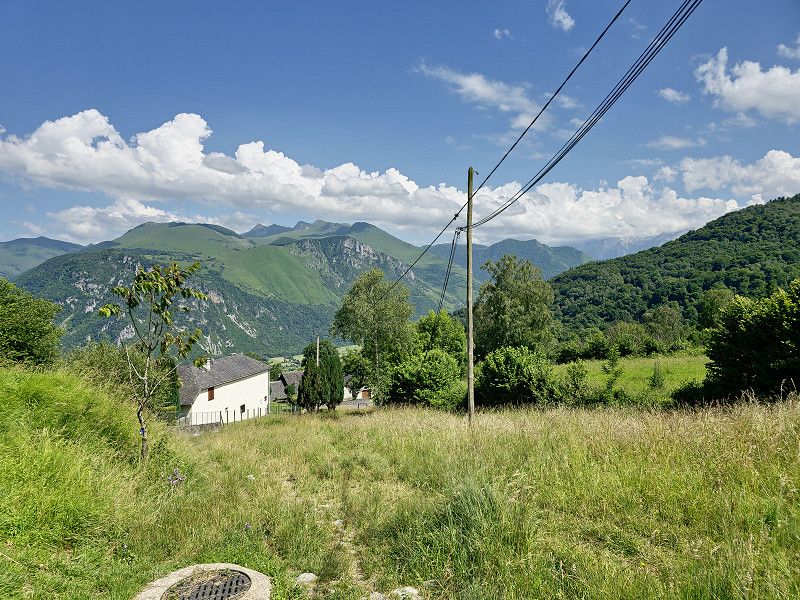
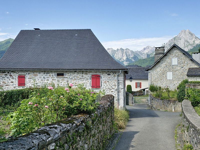
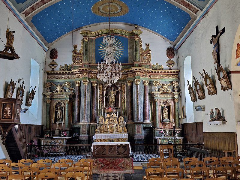
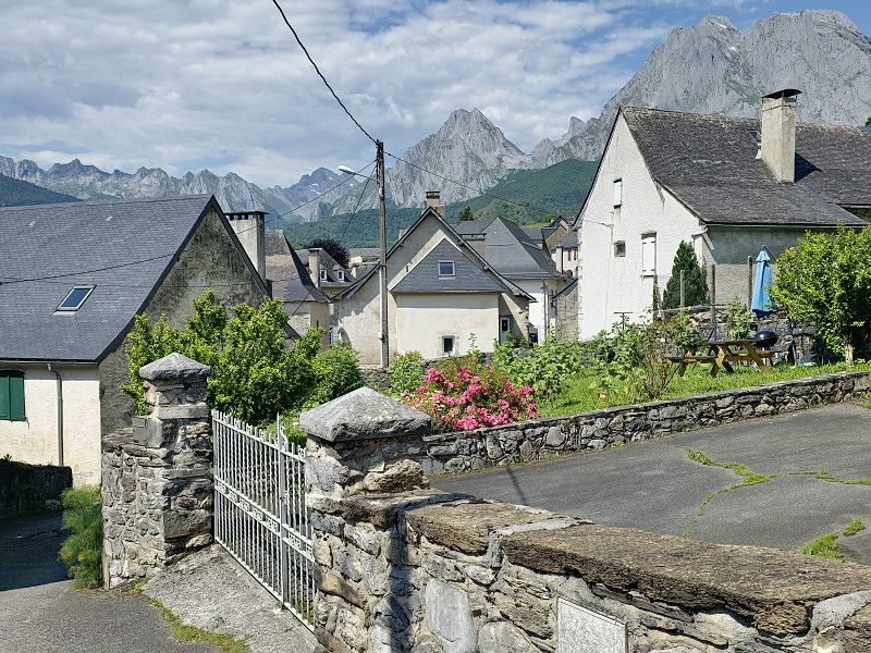
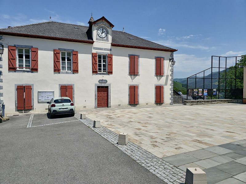
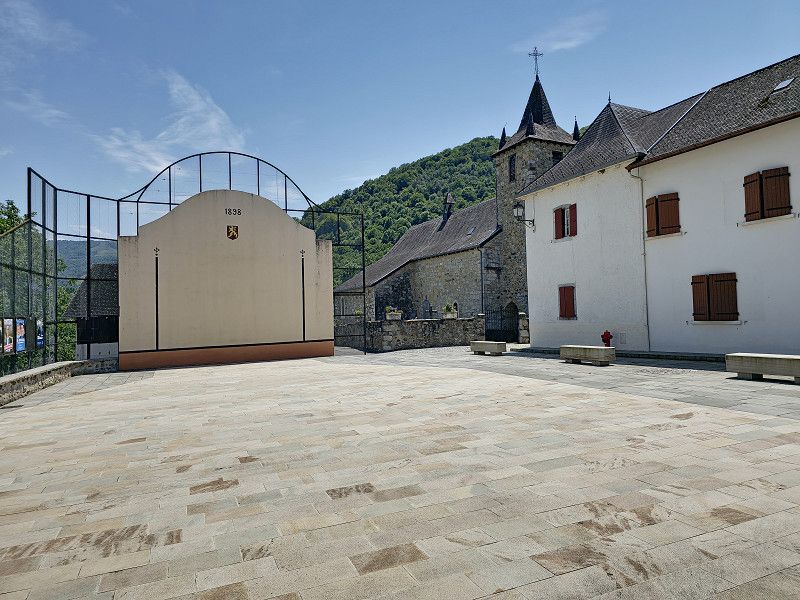
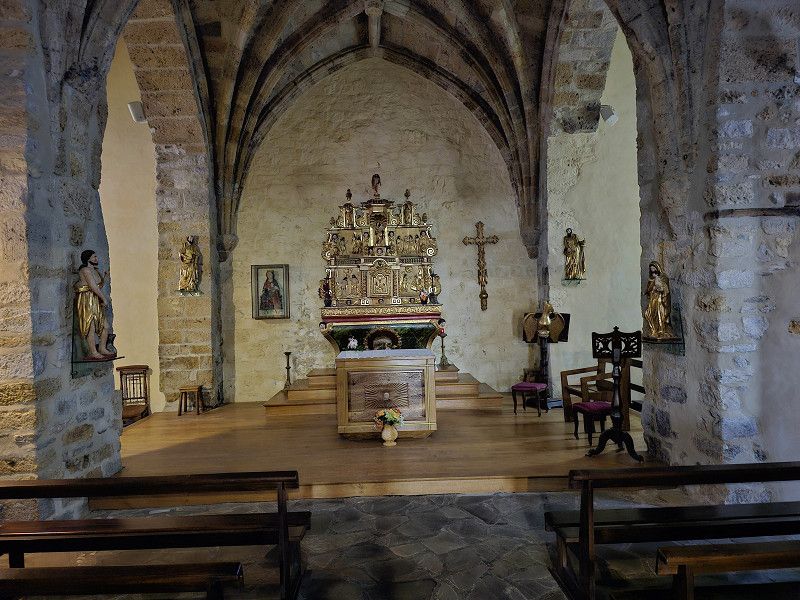
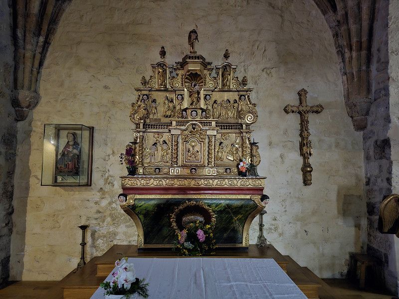
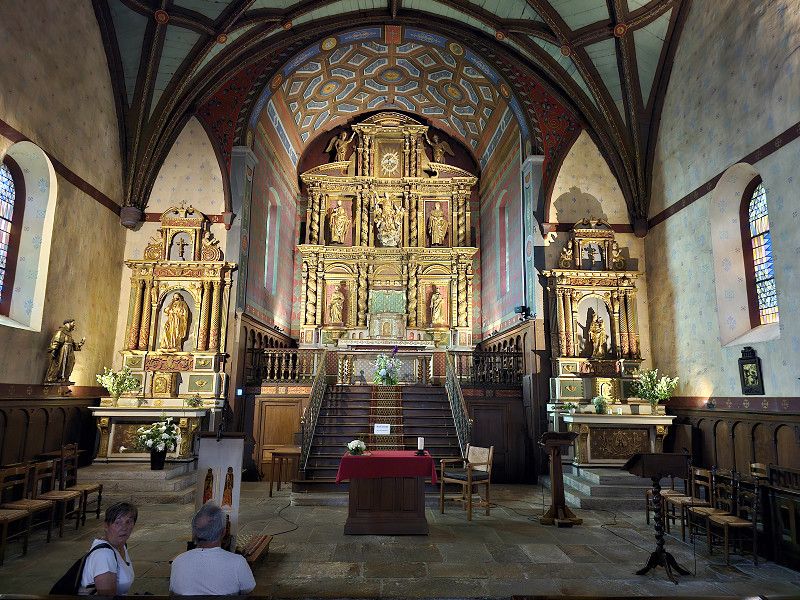
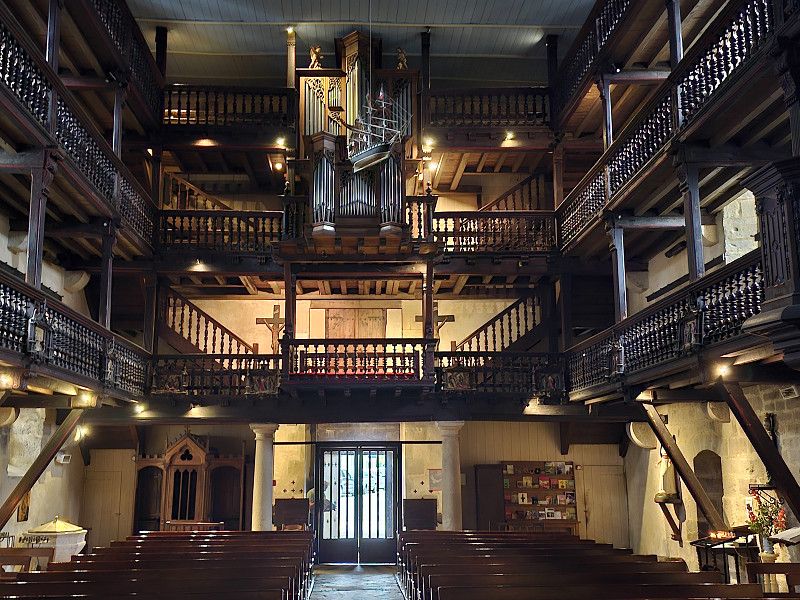
Luz-Saint-Sauveur
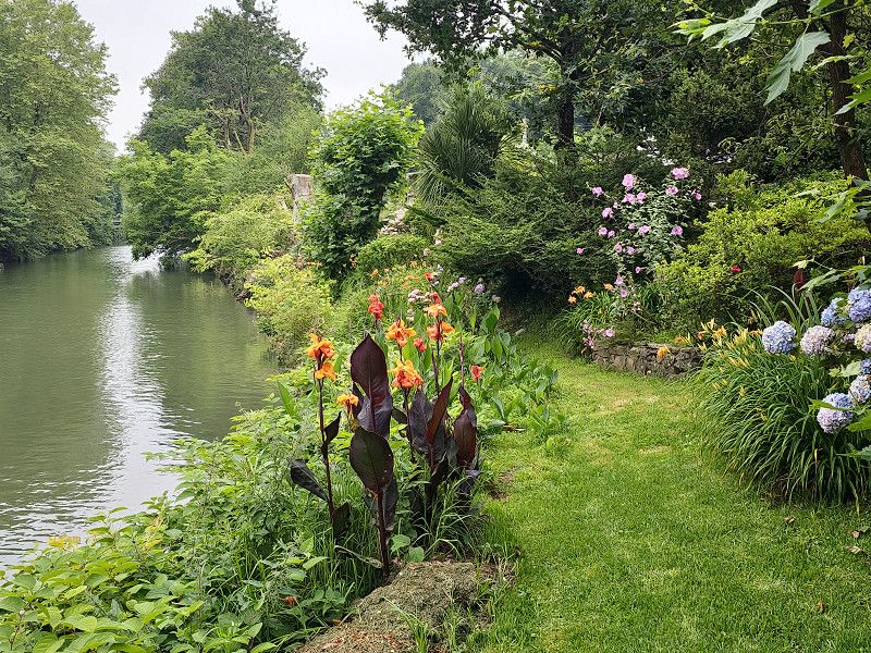
We visited the small mountain town and bought a fantastic Brebis (aged for 5 months), which tasted simply fantastic. The Église des Templiers was interesting, a massive church that also served as a defense.
Hautes-Pyrénées, Okzitanien, Frankreich
42° 52' 19.6" N 0° 0' 15.6" W
42.8721142 -0.0043418
• Head toward Avenue de Saint-Sauveur on Rue de la Poste. Go for 40 m.
• Turn left onto Avenue de Saint-Sauveur (D921). Go for 691 m.
• Continue on Route de Gavarnie (D12). Go for 3.6 km.
• Continue on Lieu-dit Sia (D921). Go for 674 m.
• Continue on D921. Go for 1.6 km.
• Continue on Lieu-dit Pragnères (D921). Go for 1.0 km.
• Continue on D921. Go for 2.1 km.
• Continue on Lieu-dit Casnabet (D921). Go for 77 m.
• Continue on D921. Go for 1.1 km.
• Continue on Gedre Debat (D921). Go for 629 m.
• Continue on D921. Go for 1.3 km.
• Continue on Lieu-dit Biroulet (D921). Go for 112 m.
• Continue on D921. Go for 2.8 km.
• Continue on Lieu-dit Couret (D921). Go for 38 m.
• Continue on D921. Go for 506 m.
• Continue on Lieu-dit Adagas (D921). Go for 104 m.
• Continue on D921. Go for 352 m.
• Continue on Lieu-dit Ribère Débat-Gavarnie (D921). Go for 116 m.
• Continue on D921. Go for 299 m.
• Continue on Lieu-dit Pujo-Gavarnie (D921). Go for 101 m.
• Continue on D921. Go for 240 m.
• Continue on Lieu-dit Bareilles (D921). Go for 65 m.
• Continue on D921. Go for 1.0 km.
• Continue on Lieu-dit Baretge (D921). Go for 108 m.
• Continue on D921. Go for 312 m.
• Turn left onto D921. Go for 362 m.
• Arrive at D921. Your destination is on the left.
☍
19,4 km
( 25 min.)
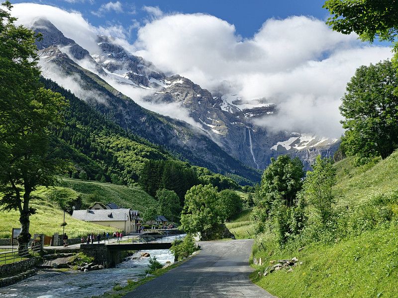
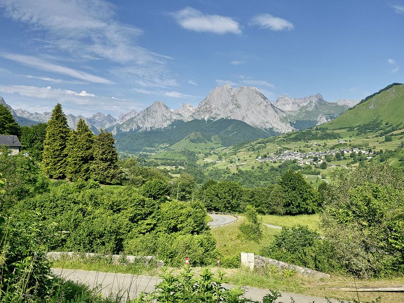
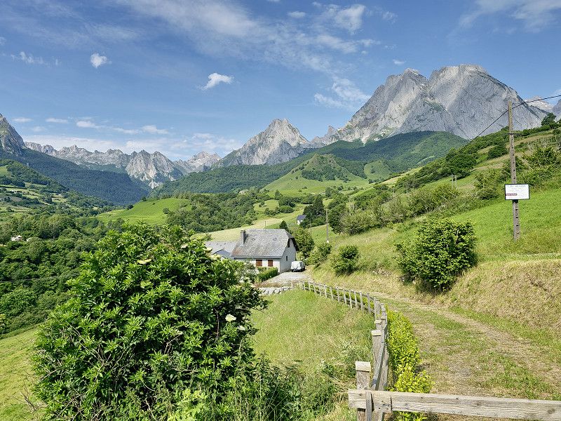
Gavarnie
Here overnight stay in the parking lot of VIVAL, GPS: 42.732786, -0.00951218
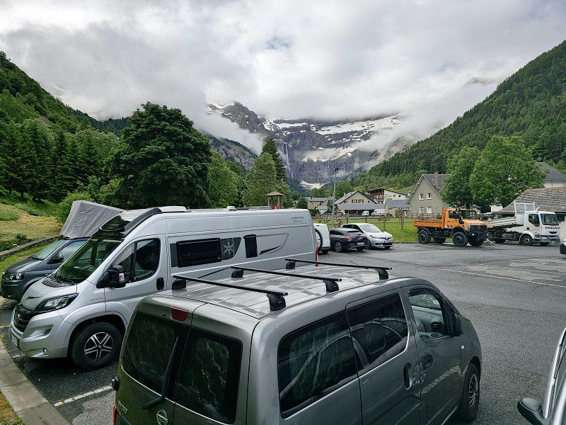
We arrived around 6:00 p.m. and everything was covered in clouds. According to the weather forecast, it should be sunny around noon tomorrow. We will definitely wait and make the hike towards the waterfall when the weather is good.
Hautes-Pyrénées, Okzitanien, Frankreich
42° 43' 55.9" N 0° 0' 33.7" W
42.7322036 -0.0093524
• Head south on D921.
• Arrive at D921. Your destination is on the left.
☍
Distance not available
(Duration not available)
Day
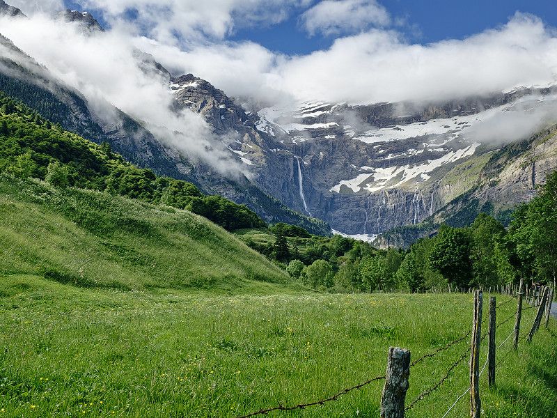
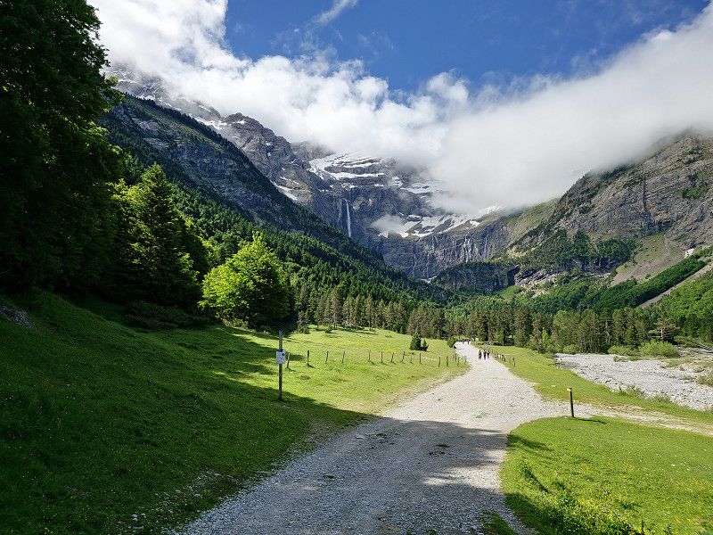
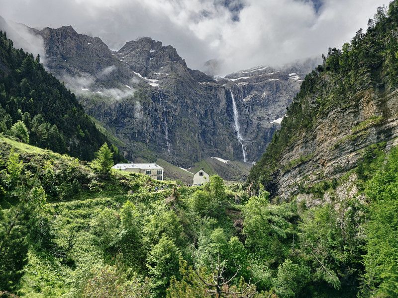
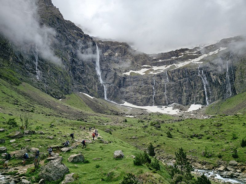
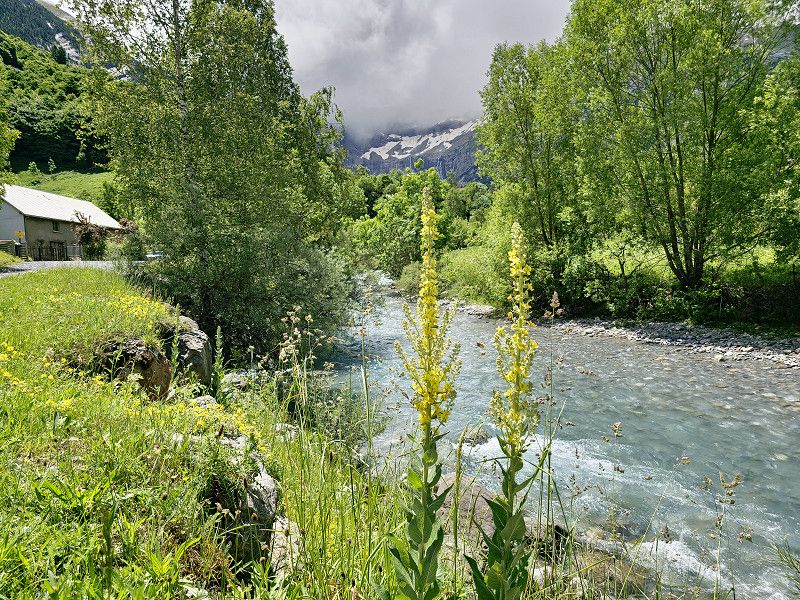
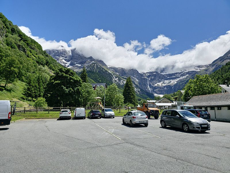
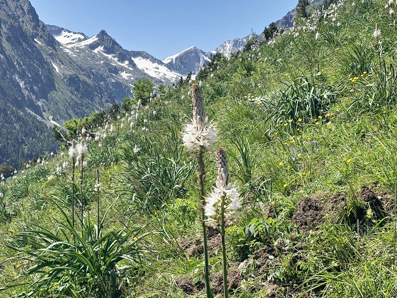
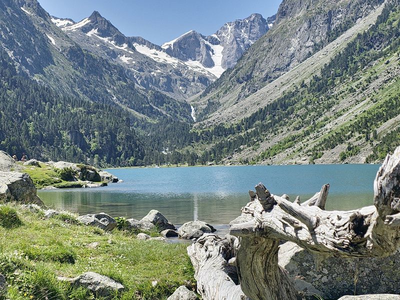
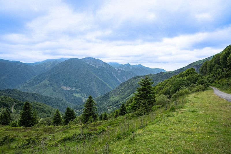
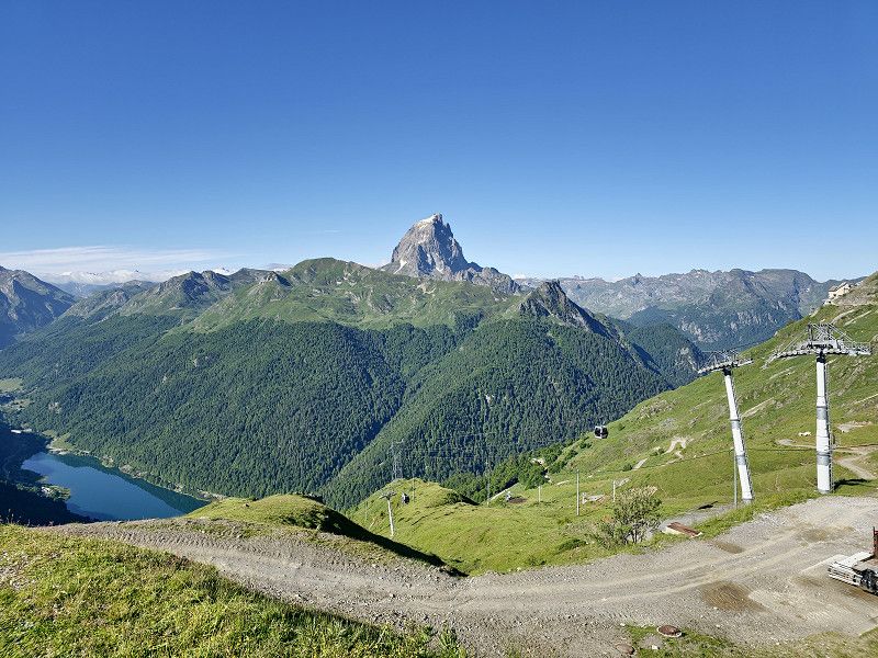
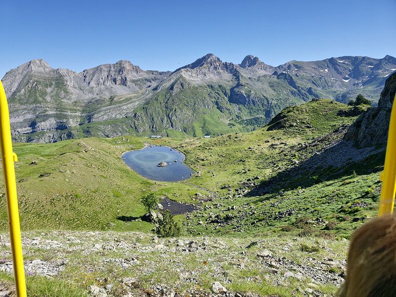
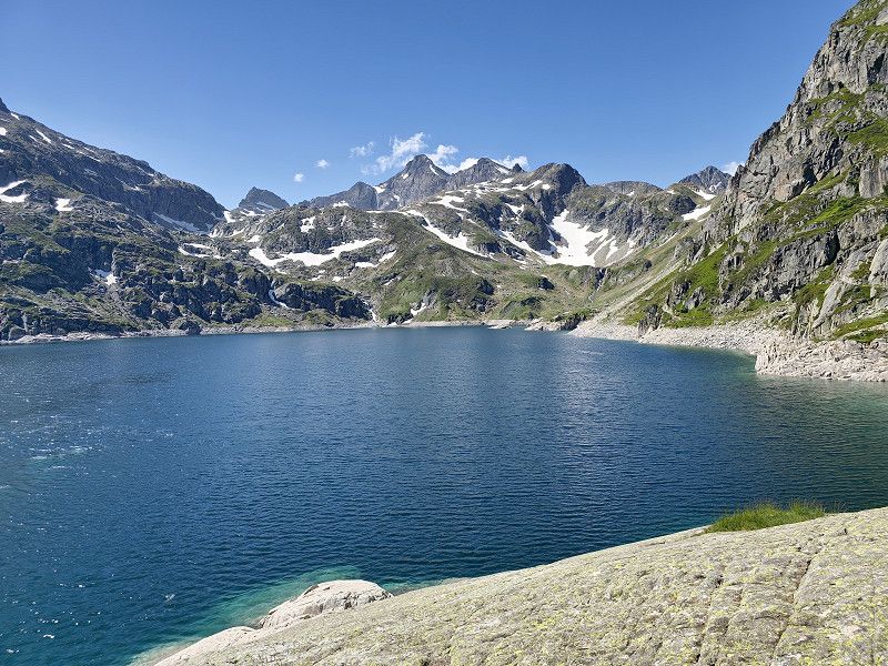
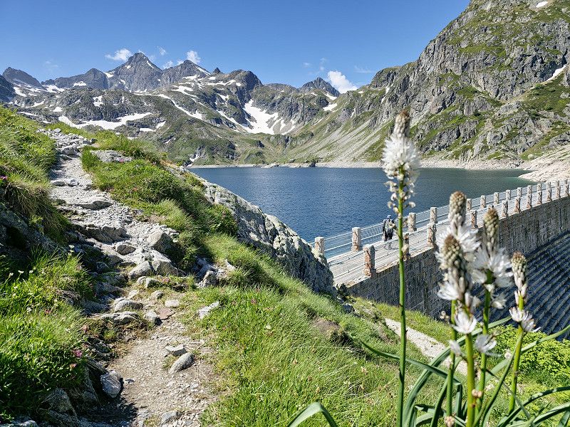
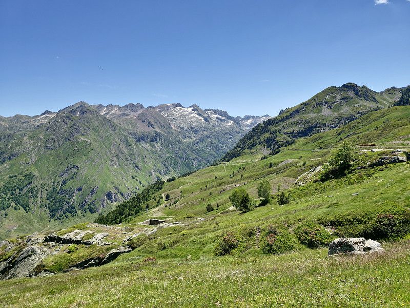
Gavarnie
Hike from Cirque de Gavernie to Cascade de Gavernie, approx. 5.2 km with 472 meters of elevation. 1 hour 45 minutes.
To the Hotel du Cirque 3.8 km 238 meters altitude difference 1:15 hours
Times are just a simple way, going back is another thing. Bicycles are prohibited.
It was partly cloudy, but it was a wonderful day and a unique natural spectacle. I'm glad we came here again. The pictures certainly don't reflect the experience.
Hautes-Pyrénées, Okzitanien, Frankreich
42° 43' 55.9" N 0° 0' 33.7" W
42.7322036 -0.0093524
• Head south on D921. Go for 752 m.
• Turn right onto D921. Go for 312 m.
• Continue on Lieu-dit Baretge (D921). Go for 108 m.
• Continue on D921. Go for 1.0 km.
• Continue on Lieu-dit Bareilles (D921). Go for 65 m.
• Continue on D921. Go for 240 m.
• Continue on Lieu-dit Pujo-Gavarnie (D921). Go for 101 m.
• Continue on D921. Go for 299 m.
• Continue on Lieu-dit Ribère Débat-Gavarnie (D921). Go for 116 m.
• Continue on D921. Go for 352 m.
• Continue on Lieu-dit Adagas (D921). Go for 104 m.
• Continue on D921. Go for 506 m.
• Continue on Lieu-dit Couret (D921). Go for 38 m.
• Continue on D921. Go for 2.8 km.
• Continue on Lieu-dit Biroulet (D921). Go for 112 m.
• Continue on D921. Go for 1.3 km.
• Continue on Gedre Debat (D921). Go for 629 m.
• Keep left onto D921. Go for 1.1 km.
• Continue on Lieu-dit Casnabet (D921). Go for 77 m.
• Continue on D921. Go for 2.1 km.
• Continue on Lieu-dit Pragnères (D921). Go for 1.0 km.
• Continue on D921. Go for 1.6 km.
• Continue on Lieu-dit Sia (D921). Go for 674 m.
• Continue on Route de Gavarnie (D921). Go for 2.4 km.
• Continue on Route de Gavarnie (D12). Go for 1.2 km.
• Turn left onto Avenue de l'Impératrice Eugénie (D921). Go for 251 m.
• Take the 1st exit from roundabout onto Route de Sassis (D12). Go for 246 m.
• Continue on D12. Go for 235 m.
• Continue on Lieu-dit Hounta (D12). Go for 172 m.
• Continue on D12. Go for 237 m.
• Take the 3rd exit from roundabout onto D12. Go for 1.2 km.
• Turn left onto D921. Go for 9.1 km.
• Take the 2nd exit from roundabout onto Route de Luz (D921). Go for 1.1 km.
• Take the 3rd exit from roundabout onto Rue Pierre Brossolette (D920). Go for 199 m.
• Continue on Avenue Pierre Brossolette (D920). Go for 283 m.
• Continue on Rue Jean-Jacques Rousseau (D920). Go for 205 m.
• Turn left onto Route de Cauterets (D920). Go for 1.7 km.
• Continue on Lieu-dit Soussu (D920). Go for 93 m.
• Continue on D920. Go for 159 m.
• Continue on Lieu-dit La Galène (D920). Go for 194 m.
• Continue on Route de Pierrefitte (D920). Go for 7.3 km.
• Keep right onto Place de la Gare (D920). Go for 70 m.
• Continue on Rue du Pont Neuf (D920). Go for 93 m.
• Continue on Place Bordenave (D920). Go for 197 m.
• Turn left onto Place Georges Clemenceau (D920). Go for 41 m.
• Continue on Place du Maréchal Foch (D920). Go for 19 m.
• Turn right onto Rue de la Raillère. Go for 578 m.
• Turn sharp right. Go for 393 m.
• Turn left. Go for 180 m.
• Arrive at your destination on the left.
☍
43,3 km
( 58 min.)
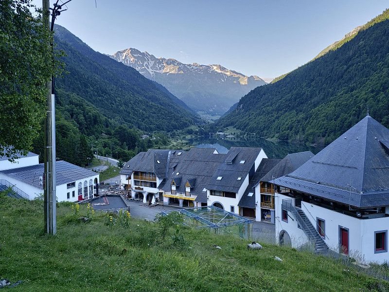
42.8865, -0.1153 Cauterets Stellplatz
Parking space in Cauterets for the night.
The parking space has everything you need, fresh water, waste disposal, electricity and is in a quiet location. The cost for the night is €12 at the parking machine. In the evening we went to the small (880 inhabitants) fashionable seaside resort for dinner.
Set off early in the morning to the Pont d'Espagne.
42.8865, -0.1153
42° 53' 11.4" N 0° 6' 55.1" W
42.8865000 -0.1153000
• Head toward Impasse La Futaie. Go for 31 m.
• Turn left onto Avenue du Docteur Charles Thierry (D920). Go for 710 m.
• Continue on Rue de la Raillère (D920). Go for 499 m.
• Keep right toward Rue de la Raillère/D920. Go for 295 m.
• Turn right onto Rue de la Raillère (D920). Go for 1.7 km.
• Continue on D920. Go for 3.6 km.
• Arrive at D920. Your destination is on the right.
☍
6,8 km
( 14 min.)
Day
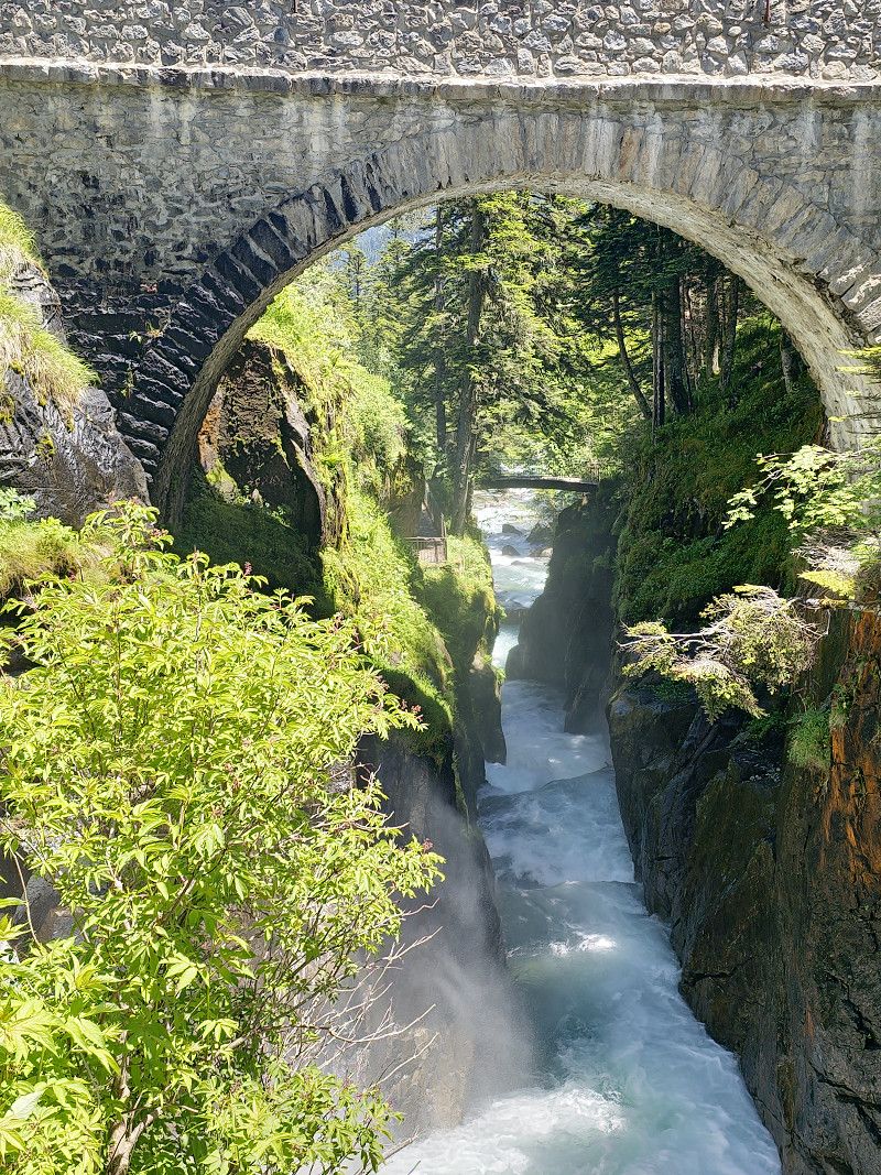
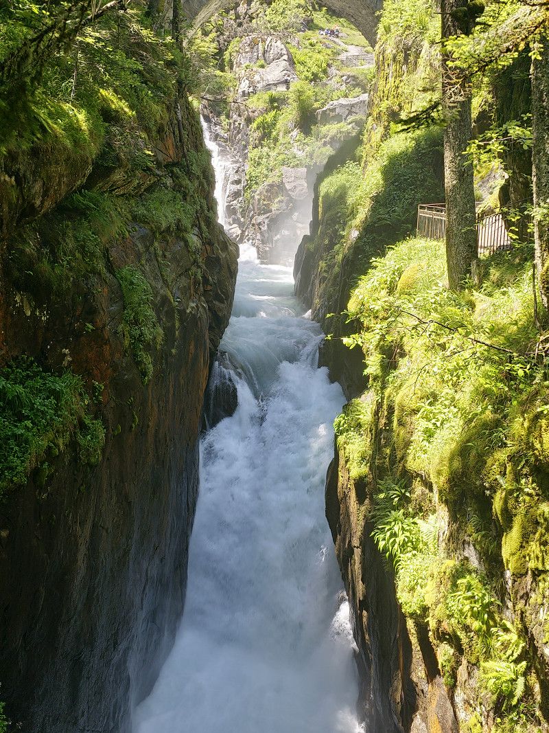
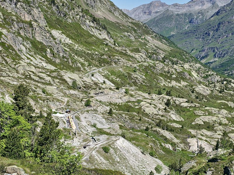
Cauterets Parkplatz Pont
Parking lot for the Pont d'Espagne. Here there is a cable car (for Marianne) up to the top of the actual Pont d'Espagne (there is also a restaurant there). I drive on to the Lac and then hike the path to Lac de Gaube.
Costs for parking, Puntas cable car and Gaube chairlift €16.00 per person. (See printout)
Time required: cable car and chair lift 20 minutes. Hike to the lake 15 minutes. Then walk to the Pont d'Espagne. Plan 3 - 4 hours in total. If you only want to see the waterfalls at the Pont d'Espagne, you don't need the cable car and chair lift. You can also hike from the car park to Lac de Gaube, but you'll need a whole day for everything. It was definitely one of the highlights of the trip.
Route du Pont d'Espagne, Cauterets, Argelès-Gazost, Hautes-Pyrénées, Frankreich
42° 51' 11.3" N 0° 8' 1.1" W
42.8531522 -0.1336344
• Head east on D920. Go for 3.6 km.
• Continue on Rue de la Raillère (D920). Go for 2.8 km.
• Turn left onto Rue de la Raillère (D12). Go for 130 m.
• Turn right onto Avenue du Docteur Charles Thierry (D920). Go for 909 m.
• Turn right onto Avenue du Mamelon Vert (D920). Go for 101 m.
• Continue on Place Georges Clemenceau (D920). Go for 41 m.
• Turn left onto Avenue du Général Leclerc. Go for 256 m.
• Turn right onto Place de la Gare (D920). Go for 70 m.
• Continue on Route de Pierrefitte (D920). Go for 3.2 km.
• Keep right onto Quartier Calypso (D920). Go for 4.1 km.
• Continue on Lieu-dit La Galène (D920). Go for 194 m.
• Continue on D920. Go for 159 m.
• Continue on Lieu-dit Soussu (D920). Go for 93 m.
• Continue on Route de Cauterets (D920). Go for 1.7 km.
• Turn right onto Rue Jean-Jacques Rousseau (D920). Go for 205 m.
• Continue on Avenue Pierre Brossolette (D920). Go for 283 m.
• Continue on Place Russel (D920). Go for 161 m.
• Take the 3rd exit from roundabout onto Avenue des Deux Ponts (D921). Go for 948 m.
• Take the 2nd exit from roundabout onto Avenue Jean Moulin (D921). Go for 4.7 km.
• Take the 2nd exit from roundabout onto Rue du Général Leclerc (D918). Go for 529 m.
• Turn right onto Place de la République. Go for 55 m.
• Continue on Rue du Capitaine Digoy. Go for 23 m.
• Turn right onto Passage d'Arnaout. Go for 20 m.
• Arrive at Passage d'Arnaout. Your destination is on the right.
☍
24,2 km
( 39 min.)
Argelès-Gazost
Hautes-Pyrénées, Okzitanien, Frankreich
43° 0' 18.4" N 0° 5' 59.2" W
43.0051100 -0.0997681
• Head toward Rue du Capitaine Digoy on Passage d'Arnaout. Go for 20 m.
• Turn right onto Rue du Capitaine Digoy. Go for 177 m.
• Continue on Rue des Poilus (D100). Go for 100 m.
• Turn right onto Rue du Maréchal Foch (D101). Go for 35 m.
• Continue on Rue du Docteur Bergugnat (D101). Go for 65 m.
• Turn left onto Rue de Vieuzac. Go for 117 m.
• Turn left onto Rue Sorbé. Go for 26 m.
• Continue on Rue Sorbe Buale. Go for 155 m.
• Continue on Place du Foirail. Go for 29 m.
• Turn right onto Place du Foirail (D918). Go for 626 m.
• Turn right onto Route de Gez (D102). Go for 433 m.
• Continue on Route d'Argelès (D102). Go for 916 m.
• Continue on Rue du Bayet (D102). Go for 248 m.
• Turn left onto Rue du Chourrot. Go for 109 m.
• Turn right onto Rue du Mont de Gez. Go for 124 m.
• Turn slightly right onto Rue du Mont de Gez. Go for 54 m.
• Turn left onto Route du Bergons. Go for 5.3 km.
• Continue on Route du Bergons. Go for 5.3 km.
• Continue on Route du Col de Spandelle. Go for 2.1 km.
• Arrive at Route du Col de Spandelle. Your destination is on the left.
☍
15,8 km
( 37 min.)
Col de Spandelles
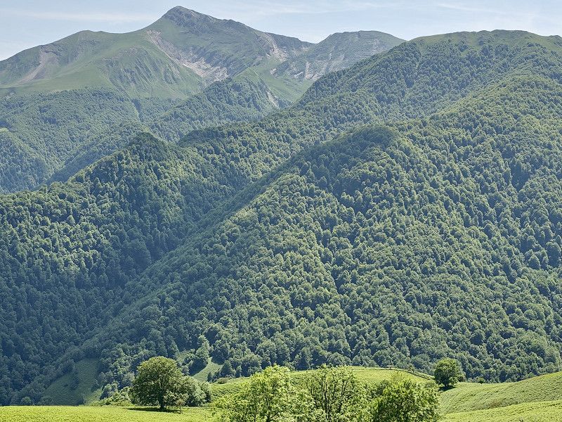
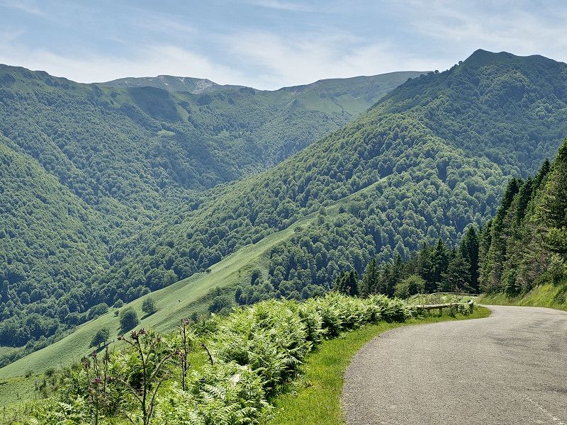
Our original plan to go over the Col de Soulor was not possible due to a total closure (landslide). So we went over the Col de Spandelles, which is very narrow in many places and hardly suitable for large motorhomes over 7 meters. We were very sorry because the originally planned trip would certainly have been even more scenic. This meant that the Gourette waypoint was also canceled.
Frankreich
43° 0' 40.8" N 0° 13' 7" W
43.0113268 -0.2186192
• Head toward Chemin de la Tire on Route du Col de Spandelle. Go for 5.5 km.
• Continue on Lieu-dit Garricat. Go for 159 m.
• Continue on Route du Col de Spandelle. Go for 2.3 km.
• Continue on Lieu-dit La Tire. Go for 148 m.
• Continue on Route du Col de Spandelle. Go for 2.0 km.
• Keep right toward D426. Go for 156 m.
• Continue on D426. Go for 2.1 km.
• Continue on Chemin d'Aygue-Nègre (D426). Go for 802 m.
• Continue on Chemin d'Aygue-Nègre (D126). Go for 2.2 km.
• Continue on Route de l'Arressec (D326). Go for 739 m.
• Continue on Route du Soulor (D126). Go for 2.9 km.
• Take the 3rd exit from roundabout onto Route du Soulor (D126). Go for 5.0 km.
• Continue on Route du Soulor (D126). Go for 1.0 km.
• Continue on Route du Soulor (D626). Go for 379 m.
• Continue on Rue d'Abère (D626). Go for 75 m.
• Turn left onto Route de Lourdes (D35). Go for 339 m.
• Take the 2nd exit from roundabout onto Rue de la Bastide (D35). Go for 17.2 km.
• Turn left onto Avenue Aristide Briand (D934). Go for 156 m.
• Take the 1st exit from roundabout onto D934. Go for 136 m.
• Take the 3rd exit from roundabout onto D934. Go for 3.0 km.
• Take the 3rd exit from roundabout onto D934. Go for 2.6 km.
• Take the 3rd exit from roundabout onto D934. Go for 1.5 km.
• Take the 3rd exit from roundabout onto D934. Go for 4.4 km.
• Take the 2nd exit from Place de la Mairie roundabout onto Rue Barthèque. Go for 221 m.
• Turn left onto Rue de Versailles. Go for 119 m.
• Turn left onto Rue du Foirail. Go for 81 m.
• Turn right onto Rue du Port (D934). Go for 19.2 km.
• Turn left onto D431. Go for 1.3 km.
• Turn left onto Résidence de l'Ours. Go for 263 m.
• Arrive at Résidence de l'Ours.
☍
76,1 km
(1 hrs. 42 min.)
Laruns
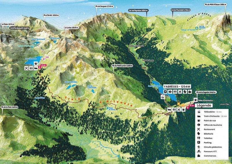
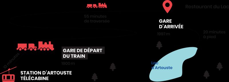
Parking for overnight stay for the miniature train ride to Lac d'Artouste. Plan at least 5 hours for the train ride.
We may have to stand on the road or at the reservoir.
Reservations at:
https://artouste.fr/ete/reservation/
Customer service is open daily from 9:00 a.m. to 6:00 p.m.
Tickets purchased online must be printed or downloaded from home.
Since the internet network in the village of Fabrèges is very weak, you cannot download the files there.
Think about it before you take the little train!
A screenshot may also be sufficient (assuming you can clearly see the QR code of each ticket).
How it works ?
15-minute gondola ride
55 minutes crossing at 2000 m altitude
1h20 free time at the lake with the Discovery ticket (1h40 in low season), the day with the Escapade ticket
Discovery ticket 27 €
We spent the night here 42.88059963, -0.39710498 on a spot above the cable car.
Pyrenäen-Atlantik, Neu-Aquitanien, Frankreich
42° 52' 46.5" N 0° 23' 53.8" W
42.8795808 -0.3982852
• Head southeast on Résidence de l'Ours. Go for 263 m.
• Continue on D431. Go for 1.3 km.
• Turn left onto D934. Go for 3.7 km.
• Arrive at D934.
☍
5,3 km
( 8 min.)
Day
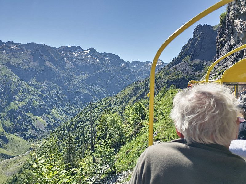
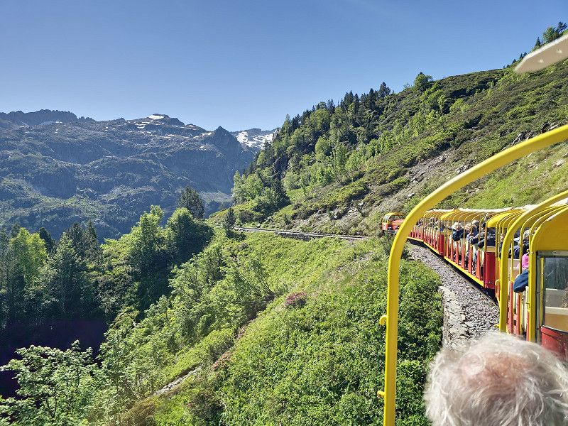
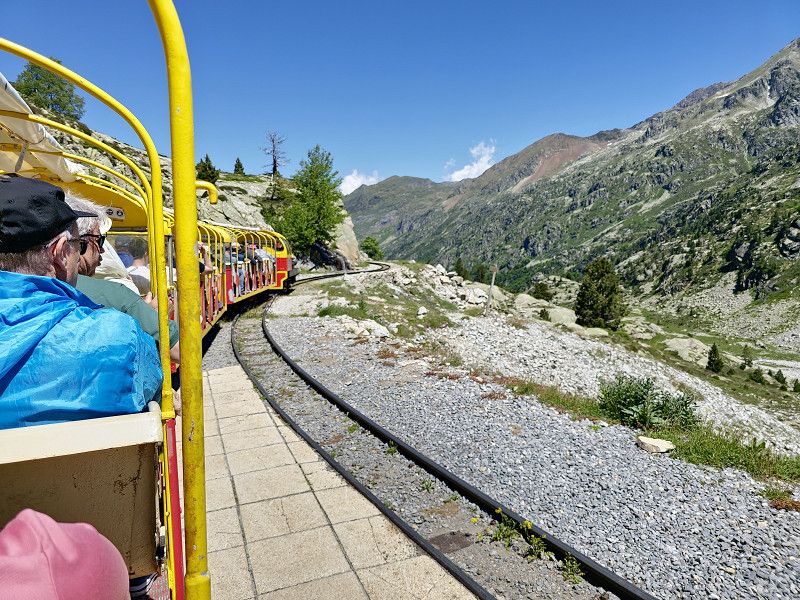
Lac d'Artouste
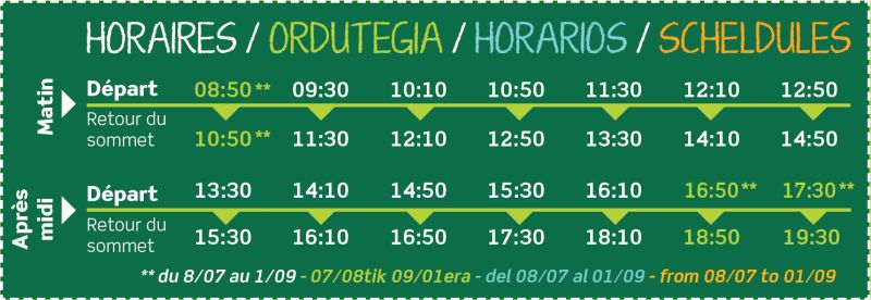
Today we take a miniature train to Lac d'Artouste. Allow at least 5 hours for the train stop.
https://artouste.fr/ete/le-train-dartouste/
High season:
6 July to 1 September
Trains depart every 30 minutes from 9 a.m. to 5 p.m.
Low season:
from 8 May to 5 July and from 2 September to 6 October.
Trains depart every hour from 10 a.m. to 3 p.m.
Discovery Ticket
3h30 excursion with 55 minutes crossing and 1h20 free time upon arrival of the train (1h40 free time in low season)
Gondola + return ticket.
Our conclusion: Simply a dream and definitely worth recommending
Frankreich
42° 51' 29.8" N 0° 19' 54.2" W
42.8582764 -0.3317347
• Head north on D934. Go for 23.2 km.
• Take the 2nd exit from Place de la Mairie roundabout onto Avenue de la Gare (D934). Go for 4.4 km.
• Take the 3rd exit from roundabout onto D934. Go for 1.5 km.
• Take the 3rd exit from roundabout onto D934 B. Go for 320 m.
• Continue on Route du Pourtalet (D934 B). Go for 1.8 km.
• Continue on D934 B. Go for 86 m.
• Continue on Route de Pau (D934 B). Go for 16 m.
• Turn left onto Rue du Bénou (D294). Go for 24 m.
• Turn right onto Rue de l'École. Go for 60 m.
• Turn left onto Rue de l'École. Go for 51 m.
• Arrive at Rue de l'École. Your destination is on the right.
☍
31,4 km
( 38 min.)
Bielle
Houses from the 16th and 17th centuries. We only drove through the town without visiting it.
Pyrenäen-Atlantik, Neu-Aquitanien, Frankreich
43° 3' 21.3" N 0° 25' 57.1" W
43.0559092 -0.4325300
• Head north on Rue de l'École. Go for 287 m.
• Turn left onto D294. Go for 609 m.
• Continue on Rue du Bénou (D294). Go for 171 m.
• Continue on D294. Go for 176 m.
• Continue on Lotissement Casamajor (D294). Go for 2.8 km.
• Continue on D294. Go for 7.4 km.
• Continue on Col de Marie-Blanque (D294). Go for 29 m.
• Arrive at Col de Marie-Blanque (D294).
☍
11,4 km
( 16 min.)
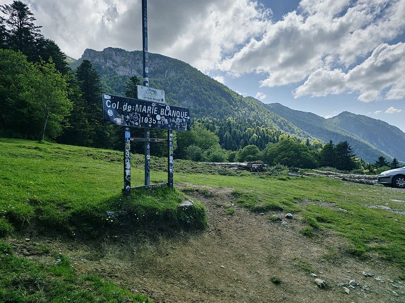
Col de Marie-Blanque
We drove through a beautiful landscape. The col is 1035 metres high and narrow in places, which is why it is probably forbidden for vehicles over 3.5 tonnes.
Frankreich
43° 4' 13.7" N 0° 30' 27" W
43.0704705 -0.5075115
• Head toward Route Forestière d'Escot on Col de Marie-Blanque (D294). Go for 29 m.
• Continue on D294. Go for 3.2 km.
• Continue on Lieu-dit Labaig (D294). Go for 175 m.
• Continue on D294. Go for 202 m.
• Continue on Lieu-dit Lagangue (D294). Go for 5.5 km.
• Turn left onto Rue de Labuchoa (D238). Go for 658 m.
• Turn left onto N134. Go for 2.4 km.
• Turn right onto Rue du Bourg. Go for 227 m.
• Arrive at Rue du Bourg. Your destination is on the left.
☍
12,4 km
( 15 min.)
Sarrance
Here you will find Monastere de Sarrance
If necessary, overnight stay at CP Aire Naturelle Camping Maison Bousquet about 6 km further. GPS: 43.0122236, -0.6012326
or
Camping Municipal de Carolle GPS: 42.99819, -0.604525
We visited the monasteries and then moved on.
Pyrenäen-Atlantik, Neu-Aquitanien, Frankreich
43° 3' 6" N 0° 36' 5.1" W
43.0516650 -0.6014075
• Head toward Place du Monastère on Rue du Bourg. Go for 89 m.
• Turn left onto Place de l'Église. Go for 147 m.
• Turn right onto N134. Go for 4.8 km.
• Pass 3 roundabouts and continue on N134. Go for 7.9 km.
• Turn right onto D239 toward Lescun/Lhers. Go for 321 m.
• Continue on Lieu-dit Bouhaben (D239). Go for 105 m.
• Continue on D239. Go for 441 m.
• Turn left onto D339. Go for 17 m.
• Continue on Lieu-dit Borde Larré (D339). Go for 145 m.
• Continue on D339. Go for 1.3 km.
• Continue on Lieu-dit Borde Bayé (D339). Go for 105 m.
• Continue on D339. Go for 242 m.
• Continue on Lieu-dit Pille (D339). Go for 76 m.
• Continue on D339. Go for 112 m.
• Continue on Lieu-dit Borde de Lamazou (D339). Go for 53 m.
• Continue on D339. Go for 798 m.
• Turn left onto D339. Go for 962 m.
• Continue on Lieu-dit Borde d'Osté (D339). Go for 86 m.
• Continue on D339. Go for 411 m.
• Turn slightly left onto D339. Go for 157 m.
• Continue on Lieu-dit Casteignau Patiolle (D339). Go for 111 m.
• Continue on Lieu-dit Castignau Lengrenat (D339). Go for 196 m.
• Continue on D339. Go for 420 m.
• Continue on Lieu-dit Camy Lapassetet (D339). Go for 165 m.
• Continue on Lieu-dit Lhers (D339). Go for 618 m.
• Continue on Lieu-dit Casala (D339). Go for 80 m.
• Continue on D339. Go for 129 m.
• Continue on Lieu-dit Nouqué (D339). Go for 88 m.
• Continue on Lieu-dit Lalheve (D339). Go for 184 m.
• Continue on D339. Go for 47 m.
• Continue on Lieu-dit Moulia Jean-Baptiste (D339). Go for 175 m.
• Continue on D339. Go for 333 m.
• Arrive at your destination on the left.
☍
20,8 km
( 27 min.)
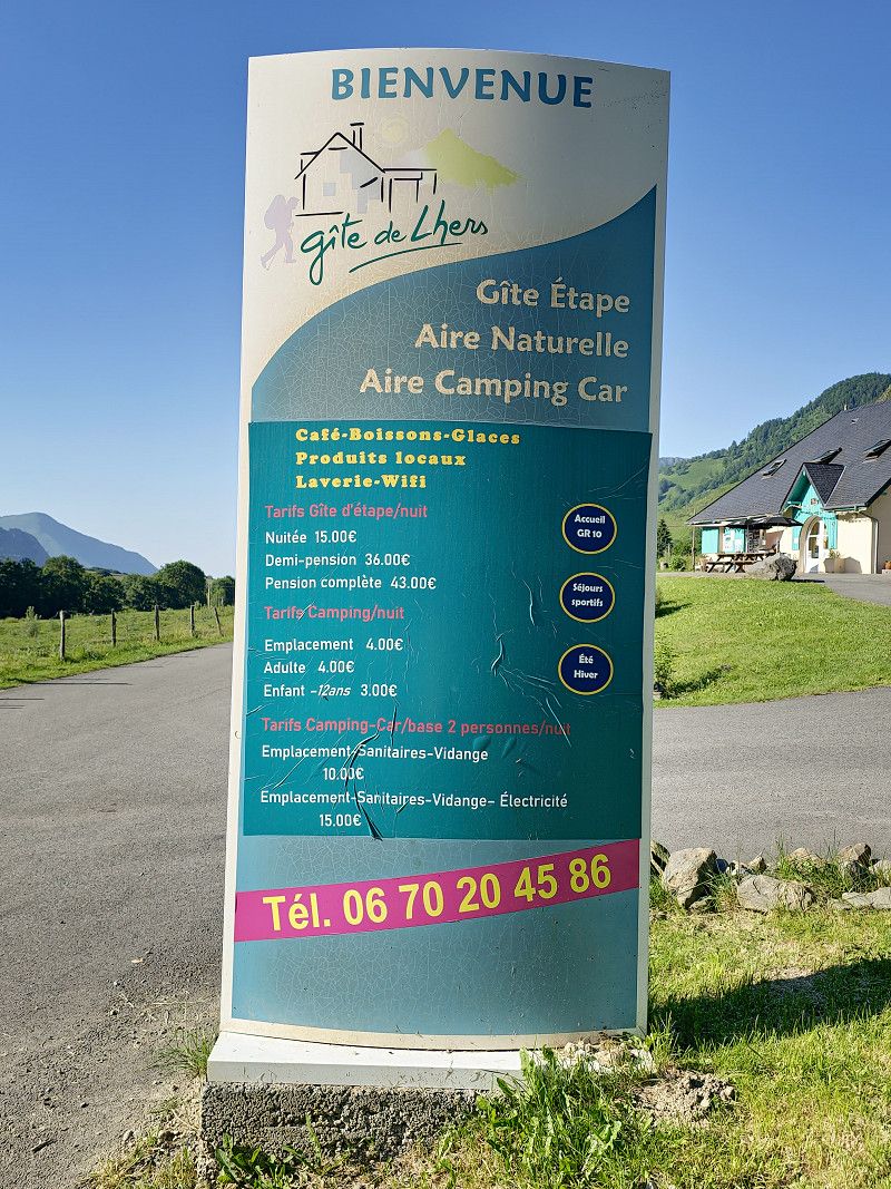
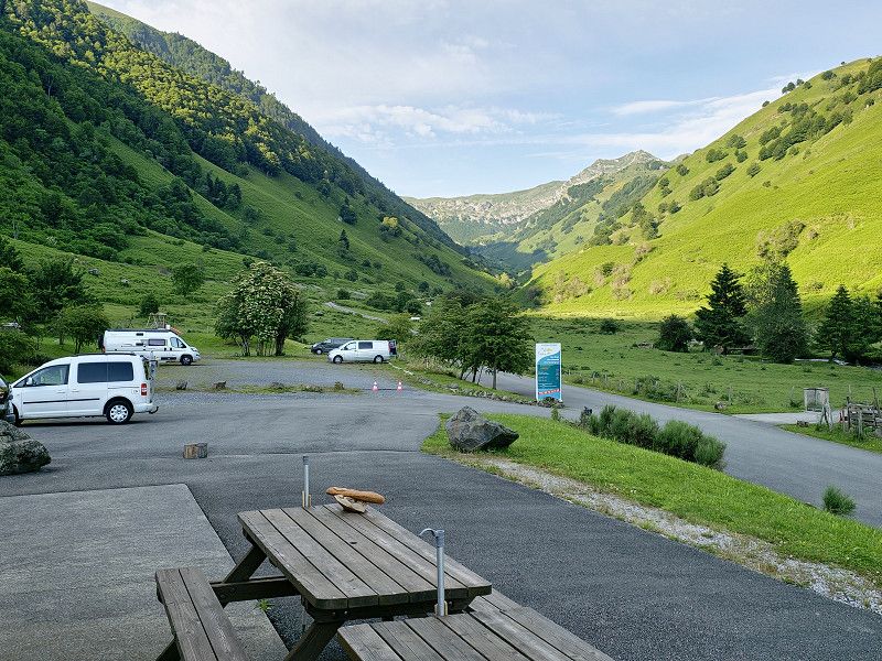
Gîte d'Etape de Lhers
We went to the campsite near Lescun, which really offers everything for €10. A wonderful landscape from which you can go on lots of hikes. Electricity costs an extra €4. But included is a sanitary facility with showers, toilets, washrooms, etc. The cleanliness here is absolutely perfect, something you rarely see at campsites. Of course, fresh water and waste disposal are also included. Can really be recommended.
Route du Parking d'Aumet, Accous, Pyrenäen-Atlantik, Neu-Aquitanien, Frankreich
42° 54' 37.9" N 0° 37' 8.7" W
42.9105258 -0.6190864
• Head north. Go for 120 m.
• Continue on D339. Go for 213 m.
• Continue on Lieu-dit Moulia Jean-Baptiste (D339). Go for 175 m.
• Continue on D339. Go for 47 m.
• Continue on Lieu-dit Lalheve (D339). Go for 184 m.
• Continue on Lieu-dit Nouqué (D339). Go for 88 m.
• Continue on D339. Go for 129 m.
• Continue on Lieu-dit Casala (D339). Go for 80 m.
• Continue on Lieu-dit Bouhaben (D339). Go for 618 m.
• Continue on Lieu-dit Camy Lapassetet (D339). Go for 165 m.
• Continue on D339. Go for 420 m.
• Continue on Lieu-dit Castignau Lengrenat (D339). Go for 196 m.
• Continue on Lieu-dit Casteignau Patiolle (D339). Go for 111 m.
• Continue on D339. Go for 568 m.
• Continue on Lieu-dit Borde d'Osté (D339). Go for 86 m.
• Continue on D339. Go for 962 m.
• Turn left onto D340. Go for 571 m.
• Continue on Lieu-dit Rachou (D340). Go for 108 m.
• Continue on Lieu-dit Asserquet (D340). Go for 201 m.
• Continue on D340. Go for 142 m.
• Continue on Lieu-dit Borde d'Orrum (D340). Go for 105 m.
• Continue on D340. Go for 286 m.
• Turn right toward Lieu-dit Borde de Claveranne. Go for 257 m.
• Continue on Lieu-dit Borde de Claveranne. Go for 179 m.
• Turn slightly right toward Lieu-dit Borde de Casaux. Go for 268 m.
• Continue on Lieu-dit Borde de Casaux. Go for 48 m.
• Turn left. Go for 812 m.
• Turn sharp left. Go for 67 m.
• Turn right toward D239. Go for 321 m.
• Continue on D239. Go for 31 m.
• Turn right toward Rue Henri Barrio. Go for 114 m.
• Turn slightly left onto Rue Henri Barrio. Go for 46 m.
• Turn left onto Lieu-dit Le Bourg. Go for 97 m.
• Arrive at Lieu-dit Le Bourg. Your destination is on the right.
☍
7,8 km
( 18 min.)
Day
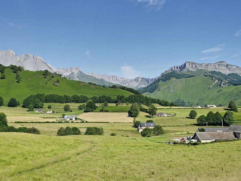
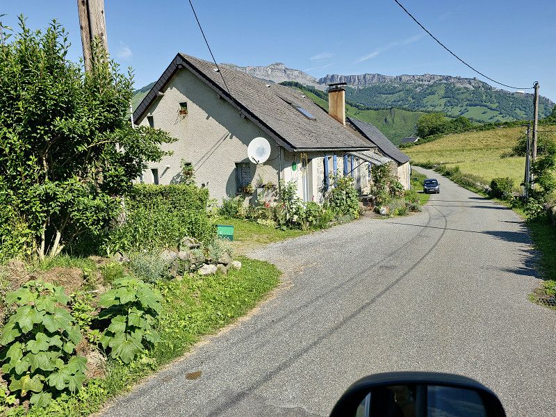
Lescun
We visited the place that is said to be one of the most beautiful villages in the Pyrenees because of its location. It is simply stunning, there are very few tourists and it offers fabulous hikes in the Cirque de Lescun.
For us it would be another goal for the future.
In Lesun you can only park on the outskirts of the town GPS: 42.931456 -0.636726. There is also a campsite (see below) in Lescun towards Cirque, which is also beautifully situated.
Pyrenäen-Atlantik, Neu-Aquitanien, Frankreich
42° 56' 8.5" N 0° 38' 5.8" W
42.9356819 -0.6349377
• Head southeast on Lieu-dit Le Bourg. Go for 97 m.
• Turn right onto Rue Henri Barrio. Go for 46 m.
• Turn slightly right. Go for 114 m.
• Turn left toward D239. Go for 20 m.
• Continue on D239. Go for 11 m.
• Continue straight ahead. Go for 321 m.
• Turn left. Go for 67 m.
• Turn sharp right toward Lieu-dit Borde de Casaux. Go for 812 m.
• Turn right onto Lieu-dit Borde de Casaux. Go for 316 m.
• Turn right. Go for 13 m.
• Arrive at your destination on the right.
☍
1,8 km
( 5 min.)
Camping du Lauzart 2
But also quiet parking on the WOMOS stand 42.927557609972084, -0.6599638261288415
We were not here as previously written
64490, Lescun, France
42° 55' 42.2" N 0° 38' 29.4" W
42.9284000 -0.6415000
• Head southeast. Go for 13 m.
• Turn right onto Lieu-dit Borde de Claveranne. Go for 436 m.
• Turn left onto D340. Go for 286 m.
• Continue on Lieu-dit Borde d'Orrum (D340). Go for 105 m.
• Continue on D340. Go for 142 m.
• Continue on Lieu-dit Asserquet (D340). Go for 201 m.
• Continue on Lieu-dit Rachou (D340). Go for 108 m.
• Continue on D340. Go for 571 m.
• Continue on D339. Go for 798 m.
• Continue on Lieu-dit Borde de Lamazou (D339). Go for 53 m.
• Continue on D339. Go for 112 m.
• Continue on Lieu-dit Pille (D339). Go for 76 m.
• Continue on D339. Go for 242 m.
• Continue on Lieu-dit Borde Bayé (D339). Go for 105 m.
• Continue on D339. Go for 1.3 km.
• Continue on Lieu-dit Borde Larré (D339). Go for 145 m.
• Continue on D339. Go for 17 m.
• Turn right onto D239. Go for 441 m.
• Continue on Lieu-dit Bouhaben (D239). Go for 105 m.
• Continue on D239. Go for 321 m.
• Turn left onto N134. Go for 2.8 km.
• Take the 2nd exit from roundabout onto N134 toward Pau/Oloron/Osse en Aspe. Go for 1.9 km.
• Pass 2 roundabouts and continue on N134. Go for 6.3 km.
• Turn left onto Route du Col d'Ichère (D241) toward Lourdios-Ichère. Go for 5.0 km.
• Continue on D241. Go for 205 m.
• Continue on Lieu-dit Carrère (D241). Go for 42 m.
• Continue on Lieu-dit Chourrout (D241). Go for 54 m.
• Continue on D241. Go for 365 m.
• Continue on Lieu-dit Gassaru (D241). Go for 104 m.
• Continue on D241. Go for 177 m.
• Continue on Lieu-dit Bordenouve (D241). Go for 81 m.
• Continue on D241. Go for 750 m.
• Continue on Lieu-dit Cantou (D241). Go for 110 m.
• Continue on Lieu-dit Caudoumecq (D241). Go for 212 m.
• Continue on D241. Go for 960 m.
• Continue on Lieu-dit Soulé (D241). Go for 128 m.
• Continue on D241. Go for 445 m.
• Turn right. Go for 25 m.
• Arrive at your destination on the left.
☍
25,3 km
( 32 min.)
Lourdios-Ichère
It was a day of pass rides because in total it is about 165 km to the destination Sare, the start of the Train de la Rhune
Pyrenäen-Atlantik, Neu-Aquitanien, Frankreich
43° 2' 58.2" N 0° 40' 0.5" W
43.0494918 -0.6668182
• Head east. Go for 134 m.
• Turn right toward D241. Go for 20 m.
• Turn right onto D241. Go for 1.1 km.
• Turn right onto D241. Go for 175 m.
• Turn left onto D341. Go for 235 m.
• Continue on Lieu-dit Maysou (D341). Go for 123 m.
• Continue on Lieu-dit Bellocq (D341). Go for 103 m.
• Continue on D341. Go for 443 m.
• Continue on Lieu-dit Labarthe (D341). Go for 95 m.
• Continue on D341. Go for 566 m.
• Continue on Lieu-dit Lembeyou (D341). Go for 86 m.
• Continue on D341. Go for 343 m.
• Continue on Lieu-dit Courétot (D341). Go for 75 m.
• Continue on D341. Go for 2.9 km.
• Continue on Lieu-dit Estournès (D341). Go for 102 m.
• Continue on D341. Go for 872 m.
• Continue on Lieu-dit Sarrelangue (D341). Go for 150 m.
• Continue on Lieu-dit Bordehore (D341). Go for 145 m.
• Continue on D341. Go for 632 m.
• Turn right onto Quartier Arrigau (D341). Go for 208 m.
• Continue on Lotissement Libarle (D341). Go for 246 m.
• Continue on Chemin de l'Arrigau (D341). Go for 68 m.
• Turn right onto Avenue Marcel Loubens (D132). Go for 357 m.
• Arrive at Avenue Marcel Loubens (D132). Your destination is on the left.
☍
9,1 km
( 13 min.)
Arette
Pyrenäen-Atlantik, Neu-Aquitanien, Frankreich
43° 5' 43.5" N 0° 43' 2" W
43.0954277 -0.7172145
• Head toward Rue Paul Ambille on Avenue Marcel Loubens (D132). Go for 18 m.
• Turn left onto Rue Pélisson (D918). Go for 2.8 km.
• Turn left onto Lieu-dit Laude-Bousquet (D918). Go for 2.2 km.
• Take the 2nd exit from roundabout onto D918. Go for 5.3 km.
• Arrive at D918. Your destination is on the left.
☍
10,4 km
( 10 min.)
Montory
Pyrenäen-Atlantik, Neu-Aquitanien, Frankreich
43° 5' 51.8" N 0° 49' 6" W
43.0977300 -0.8183340
• Head west on D918. Go for 3.7 km.
• Turn left onto D26. Go for 7.2 km.
• Take the 1st exit from roundabout onto Route de Larrau (D26). Go for 8.5 km.
• Turn left. Go for 163 m.
• Arrive at your destination on the right.
☍
19,5 km
( 20 min.)
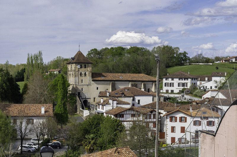
Larrau
We made a short stop here and after our lunch break we visited the small town, which is already part of the Basque Country.
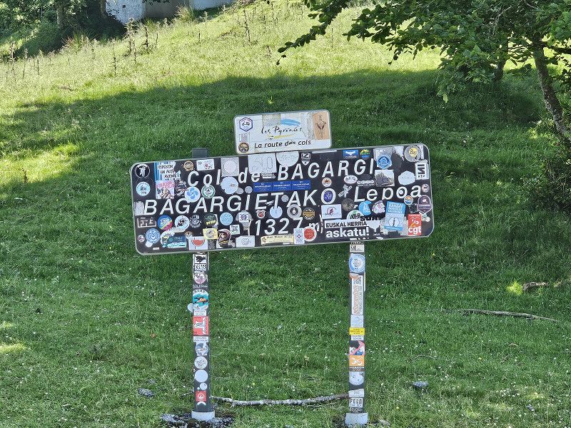
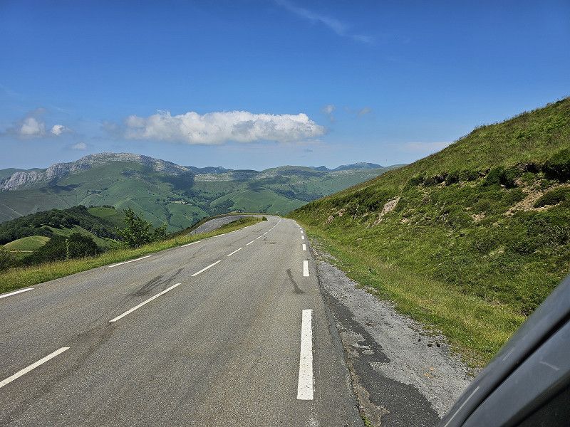
Afterwards we continued over the Col Bagargiak.
Pyrenäen-Atlantik, Neu-Aquitanien, Frankreich
43° 1' 6.2" N 0° 57' 21.3" W
43.0183998 -0.9559300
• Head north. Go for 63 m.
• Continue on Lieu-dit Le Bourg. Go for 50 m.
• Turn left onto D26. Go for 199 m.
• Turn right onto D19. Go for 1.9 km.
• Continue on Lieu-dit Uhart (D19). Go for 92 m.
• Continue on D19. Go for 351 m.
• Continue on Lieu-dit Lessartia (D19). Go for 50 m.
• Continue on D19. Go for 181 m.
• Continue on Lieu-dit Penin (D19). Go for 106 m.
• Continue on D19. Go for 642 m.
• Continue on Lieu-dit Udoya (D19). Go for 116 m.
• Continue on D19. Go for 501 m.
• Continue on Lieu-dit Barnetsborda (D19). Go for 108 m.
• Continue on D19. Go for 1.6 km.
• Continue on Lieu-dit Aguerborda (D19). Go for 112 m.
• Continue on D19. Go for 424 m.
• Continue on Lieu-dit Uthurrigoyhena (D19). Go for 82 m.
• Continue on D19. Go for 5.1 km.
• Continue on Lieu-dit Les Chalets d'Irati (D19). Go for 13 m.
• Turn right onto Quartier d'Iraty. Go for 28 m.
• Arrive at Quartier d'Iraty. Your destination is on the left.
☍
11,7 km
( 15 min.)
Parking Col de Bagargi
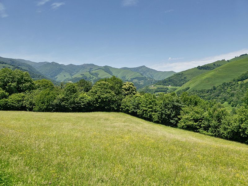
A scenic drive through the Basque countryside.
Ipar mendebaleko bidexka, Larrau, Pyrenäen-Atlantik, Neu-Aquitanien, Frankreich
43° 2' 18.1" N 1° 1' 37.4" W
43.0383692 -1.0270551
• Head toward Lieu-dit Les Chalets d'Irati on Quartier d'Iraty. Go for 28 m.
• Turn right onto Lieu-dit Les Chalets d'Irati (D19). Go for 113 m.
• Continue on D19. Go for 6.3 km.
• Turn sharp right onto D19. Go for 50 m.
• Continue on D18. Go for 9.6 km.
• Continue on Lieu-dit Puchulia (D18). Go for 102 m.
• Continue on D18. Go for 1.4 km.
• Continue on Lieu-dit Etchébestéa (D18). Go for 180 m.
• Continue on D18. Go for 262 m.
• Continue on Lieu-dit Bassaburua (D18). Go for 95 m.
• Continue on D18. Go for 510 m.
• Continue on Lieu-dit Gaïneko Officialdéguia (D18). Go for 143 m.
• Continue on D18. Go for 300 m.
• Continue on Lieu-dit Curutchéta (D18). Go for 67 m.
• Continue on D18. Go for 382 m.
• Continue on Lieu-dit Gnakeroa (D18). Go for 55 m.
• Continue on D18. Go for 504 m.
• Continue on Lieu-dit Larraldéa (D18). Go for 69 m.
• Continue on D18. Go for 520 m.
• Continue on Lieu-dit Bastida (D18). Go for 141 m.
• Continue on D18. Go for 1.3 km.
• Continue on Lieu-dit Ahatekarrika (D18). Go for 156 m.
• Continue on D18. Go for 2.0 km.
• Continue on Route de Saint-Jean-le-Vieux (D18). Go for 277 m.
• Continue on D18. Go for 317 m.
• Continue on Lieu-dit Bidartéa (D18). Go for 77 m.
• Continue on D18. Go for 336 m.
• Continue on Lieu-dit Libiéta (D18). Go for 165 m.
• Continue on D18. Go for 507 m.
• Continue on Lieu-dit Etcheverria (D18). Go for 99 m.
• Continue on D18. Go for 215 m.
• Continue on Route d'Iraty (D18). Go for 675 m.
• Continue on Lieu-dit Donapetria (D18). Go for 97 m.
• Continue on Route d'Iraty (D18). Go for 405 m.
• Continue on Lieu-dit Etchechuria (D18). Go for 42 m.
• Continue on Route d'Iraty (D18). Go for 124 m.
• Turn left onto Route du Bourg (D2933). Go for 389 m.
• Continue on D2933. Go for 408 m.
• Take the 2nd exit from roundabout onto D933 toward Pampelune/Ispoure/St Jean Pied de Port. Go for 2.8 km.
• Take the 2nd exit from roundabout onto Avenue du Jaï-Alaï (D933) toward Pampelune/Centre Ville. Go for 509 m.
• Arrive at Route d'Arnéguy à Baigt (D933). Your destination is on the right.
☍
31,7 km
( 37 min.)
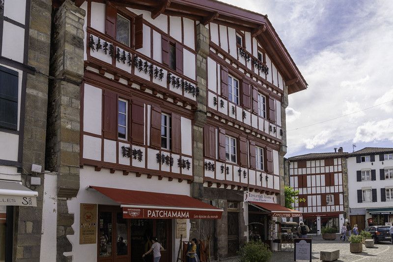
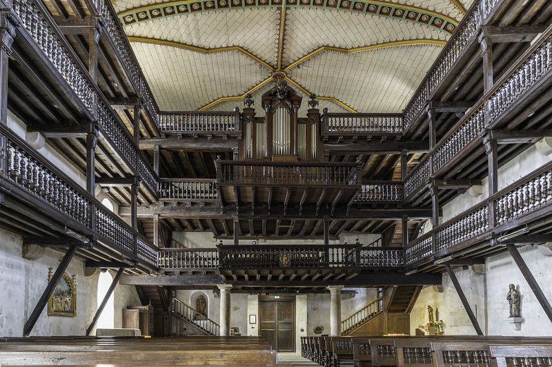
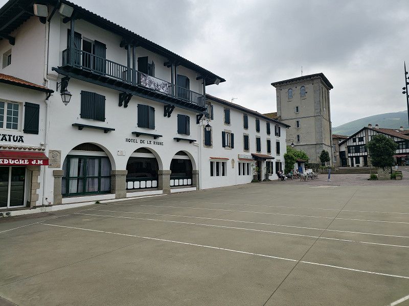
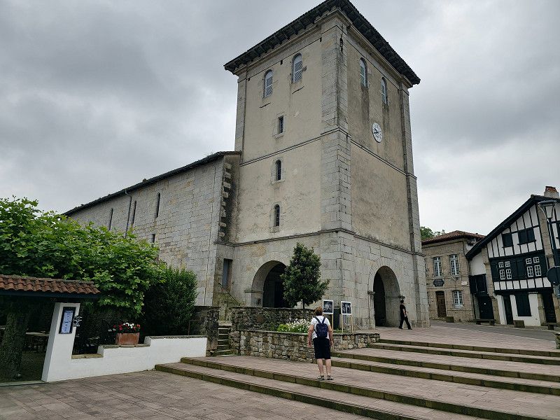
Saint-Jean-Pied-de-Port
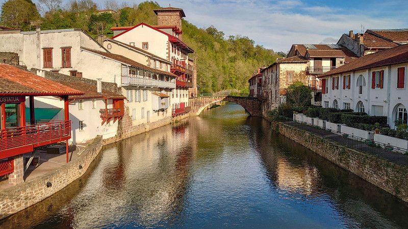
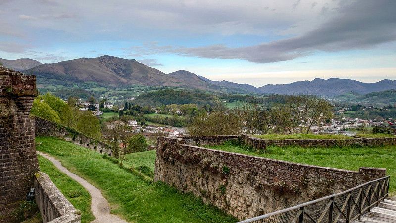
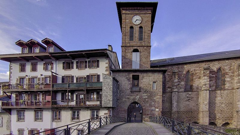
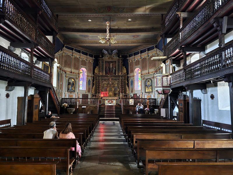
We are just driving through because we have already been in the town.
I am attaching some pictures of our previous visit. If you visit the place you can park at the following spot: GPS: 43.165312, -1.23245 or one of the 2 CP
I have described the place here: https://www.frankreich-in-wort-und-bild.de/regionen-departement-orte/dep-pyr%C3%A9n%C3%A9es-atlantiques/saint-jean-pied-de-port/
Pyrenäen-Atlantik, Neu-Aquitanien, Frankreich
43° 9' 46.6" N 1° 14' 17" W
43.1629528 -1.2380528
• Head southwest on Route d'Arnéguy à Baigt (D933). Go for 274 m.
• Keep right onto Route d'Uhart (D918) toward A63/Ossès/Cambo/Bayonne. Go for 24.6 km.
• Take the 2nd exit from roundabout onto D918 toward Itxassou/Cambo/Bayonne. Go for 4.6 km.
• Turn left onto Balakiko Errebidea (D249) toward Itxassou/Espelette. Go for 716 m.
• Take the 1st exit from roundabout onto Lieu-dit Karrika Nagusia. Go for 35 m.
• Arrive at Lieu-dit Karrika Nagusia. Your destination is on the left.
☍
30,3 km
( 26 min.)
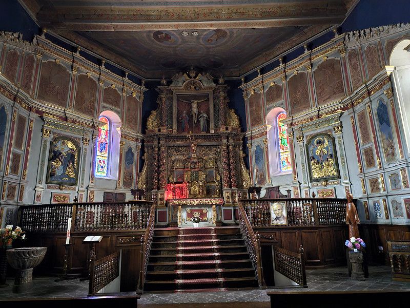
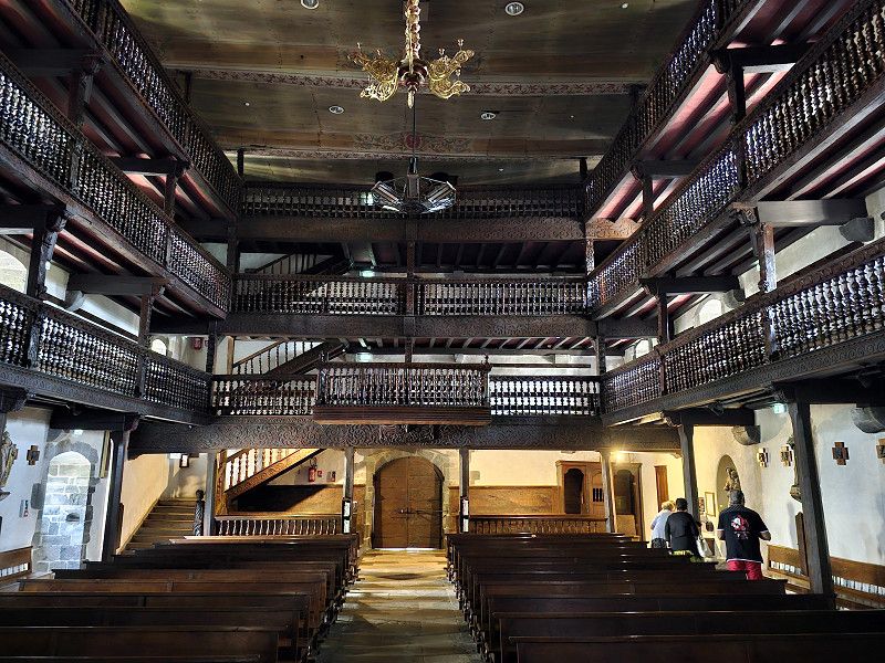
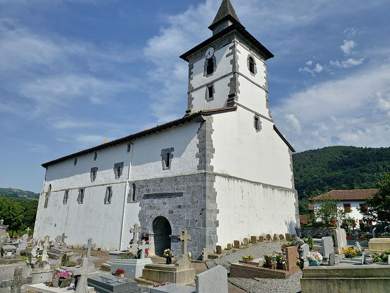
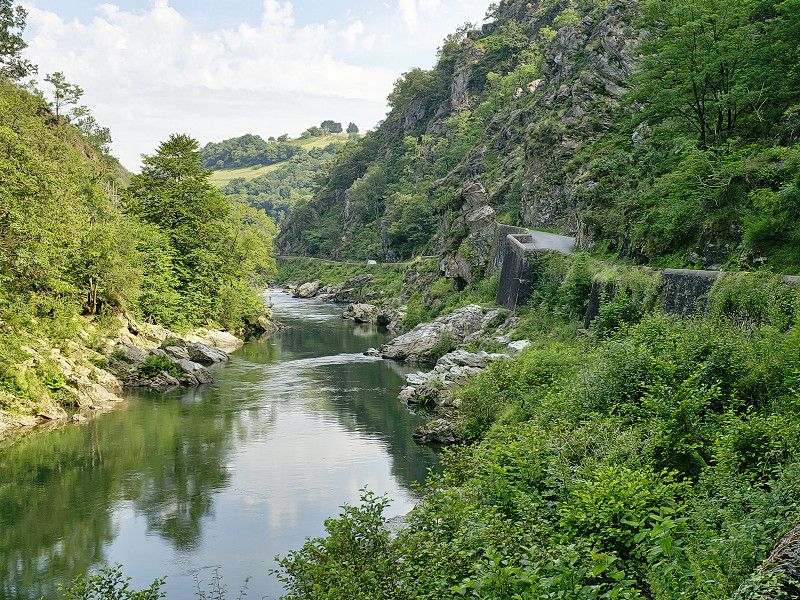
Itxassou
We visited the Saint-Fructueux church and then went on a short hike to the Pas de Roland. Please note that the car park (you can also stay overnight but no camping) at the church can be reached via GPS: 43.325575, -1.405257
Pyrenäen-Atlantik, Neu-Aquitanien, Frankreich
43° 20' 0.4" N 1° 24' 32.7" W
43.3334530 -1.4090740
• Head southwest on Lieu-dit Karrika Nagusia. Go for 25 m.
• Take the 1st exit from roundabout onto Lieu-dit Karrika Nagusia (D249). Go for 2.6 km.
• Continue on Itsasukoerrebidea (D249). Go for 2.6 km.
• Take the 2nd exit from roundabout onto Place du Marché (D249). Go for 298 m.
• Turn left onto Route Karrika Nagusia. Go for 12 m.
• Arrive at Route Karrika Nagusia. Your destination is on the right.
☍
5,5 km
( 8 min.)
Espelette
We know Espelette and so we only drove through. If you want to see more, go to my website with information about parking spaces: https://www.frankreich-in-wort-und-bild.de/regionen-departement-orte/dep-pyr%C3%A9n%C3%A9es-atlantiques/espelette/
Pyrenäen-Atlantik, Neu-Aquitanien, Frankreich
43° 20' 28.2" N 1° 26' 53.1" W
43.3411726 -1.4480830
• Head toward Xerri Karrika on Route Karrika Nagusia. Go for 64 m.
• Turn right onto Route Karrika Nagusia. Go for 15 m.
• Turn left onto Xilarreneko Karrika. Go for 80 m.
• Turn left onto Route Karrika Nagusia. Go for 156 m.
• Take the 2nd exit from roundabout onto Route Zuraide Ko Errebidea (D918). Go for 852 m.
• Turn left onto Route d'Espellett à Ainhoa (D20). Go for 4.6 km.
• Turn left onto Senpereko Bidea (D20). Go for 215 m.
• Take the 1st exit from roundabout onto Lieu-dit Karrika Nagusia (D20). Go for 375 m.
• Arrive at Rue Principale (D20). Your destination is on the right.
☍
6,3 km
( 8 min.)
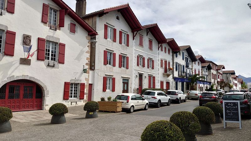
Ainhoa
We also know Ainhoa, so here is my website with information about the parking space: https://www.frankreich-in-wort-und-bild.de/regionen-departement-orte/dep-pyr%C3%A9n%C3%A9es-atlantiques/ainhoa/
Pyrenäen-Atlantik, Neu-Aquitanien, Frankreich
43° 18' 24.2" N 1° 29' 55.7" W
43.3067215 -1.4988117
• Head toward Quartier Karrika on Rue Principale (D20). Go for 362 m.
• Take the 2nd exit from roundabout onto Senpereko Bidea (D20). Go for 253 m.
• Turn left onto Senpereko Bidea (D305). Go for 1.4 km.
• Continue on Lieu-dit Chamalday (D305). Go for 775 m.
• Continue on D305. Go for 773 m.
• Turn right onto Route de Dancharia (D4). Go for 1.8 km.
• Take the 2nd exit from roundabout onto Route de Sare (D4). Go for 2.5 km.
• Take the 1st exit from roundabout onto D4. Go for 411 m.
• Turn left. Go for 257 m.
• Keep right toward Apezetxeko Bidea. Go for 103 m.
• Continue on Apezetxeko Bidea. Go for 142 m.
• Arrive at Apezetxeko Bidea. Your destination is on the left.
☍
8,8 km
( 11 min.)
Sare
We know Sare, so here is my website with parking info: https://www.frankreich-in-wort-und-bild.de/regionen-departement-orte/dep-pyr%C3%A9n%C3%A9es-atlantiques/sare/
Pyrenäen-Atlantik, Neu-Aquitanien, Frankreich
43° 18' 46.7" N 1° 34' 45.5" W
43.3129609 -1.5793011
• Head southwest on Apezetxeko Bidea. Go for 54 m.
• Turn right toward Quartier Elbarrun. Go for 187 m.
• Turn slightly right onto Quartier Elbarrun. Go for 132 m.
• Turn left onto D4. Go for 309 m.
• Take the 1st exit from roundabout onto D4. Go for 1.1 km.
• Continue on Lieu-dit Bordahandia (D4). Go for 103 m.
• Continue on D4. Go for 1.8 km.
• Continue on Col de Santo Ignacio (D4). Go for 153 m.
• Continue on D4. Go for 35 m.
• Turn left. Go for 15 m.
• Arrive at your destination on the left.
☍
3,9 km
( 6 min.)
Le Train de la Rhune
You can spend the night there in the parking lot. Take the Train de la Rhune to the summit the next day
https://www.rhune.com/fr/
Ticket price 24 €
Excursion ticket
An authentic cog railway from 1924 takes you to the summit of La Rhune at an altitude of 905 m in 35 minutes.
La Rhune is a nature reserve and is home to a particular flora and fauna such as the griffon vulture, but also the pottok (Basque pony) which lives freely on the massif. Let yourself be seduced by the beauty of nature while walking on the immense plateau of the summit of La Rhune!
Duration: total 2h30:
35 minutes ascent
1h20 stop at the summit
35 min. descent
As the weather had already changed that evening, we decided not to make the trip the next day. And this train ride certainly couldn't top the previous tour to Lac d'Artouste. However, we did spend the night in the parking lot further back and it was very quiet.
Santinazioko errebidea, Sare, Pyrenäen-Atlantik, Neu-Aquitanien, Frankreich
43° 19' 30.6" N 1° 36' 2.8" W
43.3251646 -1.6007645
• Head west. Go for 79 m.
• Turn right toward D4. Go for 66 m.
• Turn left onto D4. Go for 659 m.
• Continue on Rue San Inacio Bidea (D4). Go for 2.4 km.
• Continue on Route de Saint-Ignace (D4). Go for 167 m.
• Continue on Rue Oletako Bidea (D4). Go for 182 m.
• Turn right onto Rue Burdin Bidea. Go for 223 m.
• Turn right onto Chemin Eskola. Go for 112 m.
• Turn right onto Rue Ernest Fourneau (D504). Go for 157 m.
• Continue on Place Pierre Loti (D504). Go for 51 m.
• Arrive at Place Pierre Loti (D504). Your destination is on the left.
☍
4,1 km
( 7 min.)
Day
Ascain
Typical Basque village, visit around the village square and there the church Notre-Dame de l'Assomption 13th century and old Roman bridge.
Parking in car parks on Rue Burdin Bidea = GPS: 43.346147, -1.6233678
Since the weather was really not nice anymore and it would be overcast and rainy on the Atlantic for the next few days, we started our journey home after visiting the area. The Mediterranean was supposed to be sunny.
Pyrenäen-Atlantik, Neu-Aquitanien, Frankreich
43° 20' 41.8" N 1° 37' 15" W
43.3449393 -1.6208390
• Head toward Route de Saint-Ignace on Place Pierre Loti (D504). Go for 25 m.
• Turn right onto Rue Oletako Bidea (D4). Go for 182 m.
• Turn right onto Rue Burdin Bidea. Go for 585 m.
• Take the 2nd exit from roundabout onto Rue Ernest Fourneau (D504). Go for 121 m.
• Continue on D504. Go for 9 m.
• Continue on Rue Ernest Fourneau (D504). Go for 114 m.
• Turn left onto Route de Saint-Jean de Luz (D918). Go for 849 m.
• Take the 2nd exit from roundabout onto D918. Go for 4.6 km.
• Take the 1st exit from roundabout onto Avenue de Chantaco (D810) toward Bayonne/Guéthary Getaria/Biarritz. Go for 284 m.
• Keep right onto Avenue André Ithurralde (D810). Go for 1.1 km.
• Take the 1st exit from roundabout onto Avenue André Ithurralde (D810) toward A63/Bayonne/St Sébastien/Guéthary/Biarritz/Donostia. Go for 447 m.
• Take the 3rd exit from roundabout onto Avenue André Ithurralde (D810) toward Bayonne/Biarritz. Go for 1.4 km.
• Take ramp. Go for 130 m.
• Turn left. Go for 77 m.
• Turn left toward Chemin Chibau. Go for 52 m.
• Continue on Chemin Chibau. Go for 124 m.
• Continue on Chemin de Chibau. Go for 423 m.
• Take the 3rd exit from roundabout onto Chemin de la Côte. Go for 362 m.
• Turn slightly left onto Chemin de la Côte. Go for 12 m.
• Continue on Chemin de Chibau Berria. Go for 171 m.
• Turn left onto Chemin de Chibau Berria. Go for 29 m.
• Arrive at Chemin de Chibau Berria. Your destination is on the right.
☍
11,1 km
( 17 min.)
Camping Municipal Chibaou-berria
Alternative to pitch, Tel: 05 59 26 11 94. CP has bus line to Biarritz and San Sebastian.
If we stay at the sea for several days we only use CP so
- Flower Camping La Ferme Erromardie, Tel: 05 59 26 34 26 (recommended by a FB friend)
GPS: 43.40666, -1.641268
- Camping Merko-Laccara, GPS: 43.41874, -1.623329
- CP L´International Erromardie,
GPS: 43.40627, -1.63727
- CP Inter-Plages
GPS: 43.414980, -1.626539
- CP Soubelet
GPS: 43.416584, -1.62528
- CP Tamaris Plage
GPS: 43.418085, -1.624158
Cancelled due to bad weather
64500, St Jean De Luz, Frankreich
43° 24' 32" N 1° 38' 12.1" W
43.4089000 -1.6367000
• Head south on Chemin de Chibau Berria. Go for 74 m.
• Take the 3rd exit from roundabout onto Chemin de Chibau Berria. Go for 143 m.
• Turn right onto Chemin de Chibau Berria. Go for 171 m.
• Continue on Chemin de la Côte. Go for 317 m.
• Turn right onto Chemin de Chibau. Go for 22 m.
• Turn right onto Chemin de Chibau. Go for 466 m.
• Continue on Chemin Chibau. Go for 120 m.
• Turn right toward D810. Go for 77 m.
• Turn left and take ramp onto D810. Go for 889 m.
• Pass 4 roundabouts and continue on Avenue du Plateau (D810). Go for 5.1 km.
• Turn left onto Avenue de Biarritz (D911). Go for 1.7 km.
• Take the 3rd exit from Rond-Point Maïté Barnetche roundabout onto Avenue de Biarritz (D911). Go for 498 m.
• Take the 1st exit from Avenue de la Milady roundabout onto Avenue de la Milady (D911). Go for 373 m.
• Take the 1st exit from Avenue de la Milady roundabout onto Chemin des Prés. Go for 109 m.
• Arrive at your destination on the right.
☍
10,1 km
( 15 min.)
Parking de la Milady
Pitch at Camping Car Park in front of Biarritz, 200 meters from the bus stop, 2 km from the old town. Very noisy. Only if we can't get another place.
Another quiet pitch at Camping Car Park 43.459671° -1.56886° about 1.2 km from the sea.
Additional parking space 3 km north of the center of Biarritz on the beach, 43.50695, -1.53372
Cancelled due to bad weather
Avenue de la Milady, 64200, Biarritz, Frankreich
43° 27' 58" N 1° 34' 18" W
43.4661111 -1.5716667
• Head north. Go for 147 m.
• Turn right toward Chemin des Prés. Go for 18 m.
• Continue on Chemin des Prés. Go for 46 m.
• Take the 3rd exit from Avenue de la Milady roundabout onto Avenue de la Milady (D911). Go for 382 m.
• Take the 2nd exit from Avenue de la Milady roundabout onto Avenue de la Milady (D911). Go for 500 m.
• Keep right onto Avenue de Biarritz (D911). Go for 39 m.
• Take the 2nd exit from Rond-Point Maïté Barnetche roundabout onto Avenue de Biarritz (D911). Go for 870 m.
• Turn left onto Rue de l'Étape (D655). Go for 475 m.
• Take the 3rd exit from roundabout onto Parc d'Acivités de la Source (D810). Go for 362 m.
• Take the 3rd exit from roundabout. Go for 75 m.
• Continue on Avenue de Bayonne (D810). Go for 1.4 km.
• Take the 2nd exit from roundabout toward A63/A63-A64/Saint Jean de Luz/San Sébastien/Bayonne/Bordeaux. Go for 130 m.
• Take ramp onto A63 (Autoroute de la Côte Basque) toward Bordeaux/Bayonne. Go for 10.0 km.
• Take the exit toward A64/E80/Toulouse/Pau/Bayonne-Mousserolles onto D1 (Échangeur de Bayonne-Mousserolles). Go for 10.9 km.
• Keep left onto A64 (La Pyrénéenne). Go for 276 km.
• Take the exit toward Albi/Montpellier/Foix/Toulouse-Centre/Empalot onto A620 (Échangeur de la Croix de Pierre). Go for 3.1 km.
• Take exit 23 toward Rangueil/Hôpital Rangueil-Larrey/Hôpital onto M113 (Route de Narbonne). Go for 3.4 km.
• Take the 2nd exit from roundabout onto Avenue Pierre-Georges Latécoère (A623) toward Montpellier/Bordeaux/Carcassonne/Toulouse-Centre/Aéroport de Blagnac/Labège/Z.I. de Montaudran. Go for 1.1 km.
• Take the 1st exit from roundabout onto A620 (Échangeur du Palays) toward Carcassonne/Foix. Go for 1.8 km.
• Continue on A61 (Autoroute des Deux Mers). Go for 137 km.
• Take the left exit toward E15/Lyon/Montpellier/Béziers onto A9 (La Languedocienne). Go for 33.5 km.
• Take the exit toward Clermont-Fd/Millau/Béziers-Centre/Aéroport Béziers-Cap d'Agde onto A75. Go for 3.0 km.
• Take exit 64 toward Sérignan. Go for 1.7 km.
• Take the 2nd exit from Rond-Point des Étoiles roundabout toward Sérignan/Villeneuve lès B./Aéroport Béziers Cap d'Agde/Béziers-Gare/Béziers-la Devèze. Go for 193 m.
• Take the 2nd exit from Rond-Point du 9 Mai roundabout onto D612 toward Valras Plage/Sérignan/Villeneuve lès B./Aéroport Béziers-Cap d'Agde. Go for 2.0 km.
• Take the 3rd exit from Rond-Point de la Méditerranée roundabout onto D612 toward Sète/Cers/Portiragnes. Go for 2.1 km.
• Turn right onto Route de Portiragnes (D37) toward Portiragnes-Plage/Port Cassafières. Go for 634 m.
• Continue on Chemin de Béziers (D37). Go for 406 m.
• Continue on Lieu-dit La Prade (D37). Go for 165 m.
• Continue on Chemin de Béziers (D37). Go for 59 m.
• Continue on Avenue de Béziers (D37). Go for 431 m.
• Continue on D37. Go for 36 m.
• Continue on Avenue de Béziers (D37). Go for 102 m.
• Take the 1st exit from roundabout onto D37. Go for 688 m.
• Pass 2 roundabouts and continue on D37. Go for 3.2 km.
• Take the 1st exit from roundabout onto Avenue de la Tour de l'Orb. Go for 707 m.
• Turn right onto Avenue du Grand Salan. Go for 516 m.
• Turn slightly left onto Avenue de la Grande Maïre. Go for 260 m.
• Take the 1st exit from roundabout onto Avenue de la Grande Maïre. Go for 314 m.
• Arrive at Avenue de la Grande Maïre. Your destination is on the left.
☍
497,6 km
(4 hrs. 21 min.)
43.2747586, 3.3517349
The pitch is about 100-150 metres from the sandy beach. It has waste disposal, fresh water and electricity, costs €16.88
What I didn't like was the fresh water right next to the toilet flush, a real disadvantage. Luckily, we didn't need fresh water.
43° 16' 29.1" N 3° 21' 6.2" E
43.2747586 3.3517349
• Head south on Avenue de la Grande Maïre.
• Arrive at Avenue de la Grande Maïre. Your destination is on the left.
☍
Distance not available
(Duration not available)
Day
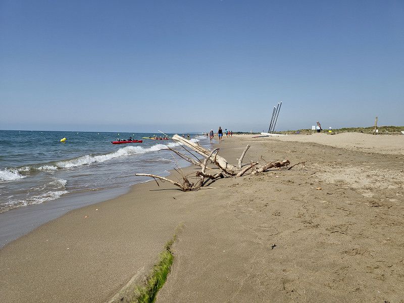
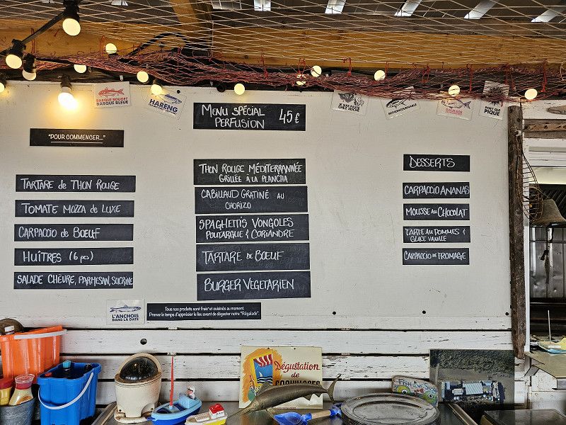
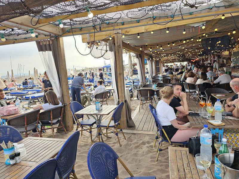
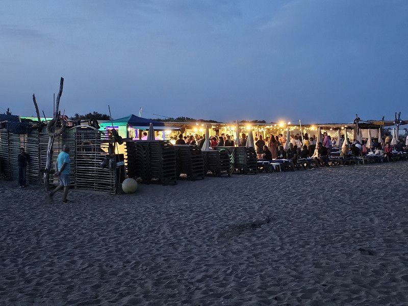
43.2747586, 3.3517349 Camping Car Park
We enjoyed the beach and the sea here. We had a two-day delay because the bad weather followed the next day.
There is a beach bar right in front of the pitch on the beach where you can also get food in the evening. At the time we were there there was even a small party with music and a 3-course meal
43.2747586, 3.3517349
43° 16' 29.1" N 3° 21' 6.2" E
43.2747586 3.3517349
• Head north on Avenue de la Grande Maïre. Go for 278 m.
• Take the 2nd exit from roundabout onto Avenue de la Grande Maïre. Go for 302 m.
• Turn slightly right onto Avenue du Grand Salan. Go for 516 m.
• Turn left onto Avenue de la Tour de l'Orb. Go for 653 m.
• Take the 2nd exit from roundabout onto D37. Go for 2.3 km.
• Take the 2nd exit from roundabout onto D37. Go for 931 m.
• Take the 1st exit from Rond-Point de Vieille Brioude roundabout onto Rue Louis Buffon. Go for 244 m.
• Continue on Avenue François Mitterrand. Go for 242 m.
• Continue on Boulevard Frédéric Mistral. Go for 72 m.
• Continue on Avenue du 22 Août 44. Go for 136 m.
• Continue on Avenue du Général de Gaulle (D37 E15). Go for 945 m.
• Take the 1st exit from roundabout onto D612. Go for 1.9 km.
• Take the 2nd exit from roundabout onto D612 toward Sète/Vias/Agde. Go for 6.1 km.
• Take ramp onto D612 A toward A9/Millau/Bessan/Pézenas. Go for 8.2 km.
• Take the 2nd exit from roundabout onto A9 (La Languedocienne) toward Montpellier. Go for 120 km.
• Take exit 23 toward Avignon. Go for 1.0 km.
• Take the 1st exit from roundabout onto N100 toward A7/Avignon. Go for 3.5 km.
• Pass 5 roundabouts and continue on N100. Go for 14.5 km.
• Keep left toward Centre Ville. Go for 154 m.
• Continue on Boulevard Saint-Dominique (N570). Go for 890 m.
• Continue on Boulevard Saint-Michel (N270). Go for 524 m.
• Turn right onto Avenue Pierre Semard. Go for 700 m.
• Pass 3 roundabouts and continue on Avenue Pierre Semard. Go for 2.4 km.
• Take the 2nd exit from roundabout onto Route de Marseille (N7) toward A7/Cavaillon/Salon/Aix en Pce/Aéroport Cantarel. Go for 2.7 km.
• Pass 2 roundabouts and continue on Route de Marseille (N7). Go for 4.4 km.
• Keep right onto Route de Marseille (D900). Go for 259 m.
• Keep right onto Route de Cavaillon (D900). Go for 7.6 km.
• Pass 2 roundabouts and continue on Chemin de Romieu (D900). Go for 5.0 km.
• Take the 3rd exit from roundabout onto Chemin de Romieu (D900). Go for 1.2 km.
• Take the 1st exit from roundabout onto Route de L'Isle-sur-la-Sorgue (D31) toward Robion. Go for 1.8 km.
• Continue on Lieu-dit Le Plan de Robion (D31). Go for 206 m.
• Take the 2nd exit from Rond-Point Charles Reboul roundabout onto Route de l'Isle-sur-la-Sorgue (D31). Go for 1.7 km.
• Take the 3rd exit from roundabout onto Avenue de la Gare (D31). Go for 148 m.
• Take the 2nd exit from roundabout onto Rue Oscar Roulet. Go for 475 m.
• Continue on Place de la Mairie. Go for 91 m.
• Turn right onto Place de l'Église. Go for 15 m.
• Arrive at Place de l'Église. Your destination is on the right.
☍
191,6 km
(2 hrs. 10 min.)
Day
Robion
Vaucluse, Provence-Alpes-Côte d'Azur, Frankreich
43° 50' 38.8" N 5° 6' 44" E
43.8441157 5.1122150