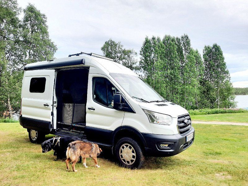
3 months with 2 dogs and 4x4 almost self-sufficient through Northern Europe.
Conclusion of the 2nd part: drive fewer kilometers. Not only to save immense fuel costs, but also to be able to better enjoy the really beautiful places. Because even three months will eventually become too short. Especially when you have so many periods of rain and you have to constantly cancel hiking routes or beach recreation because of constant rain.
We read a lot about mosquitoes in Finland and Sweden but had no idea of the truth. OMG!
Our newly expanded Womo definitely needs to be rebuilt. Less comfort for the dogs and us, but it needs to become more workable when you're stuck in your car for days because you can't get out (also for our planned winter tours to Norway). Either because it's raining or the bloodsuckers are waiting for you.
Personally, we didn't like the south of Finland and Sweden at all. We are apparently Lapland fans. It's the same in Norway (we've been there 4 times). But the south of Norway at least has glaciers to visit or high mountains to hike. Which would be great for Finland if you have a boat or kayak with you. You can cruise there for days.
What saddened us as die-hard fans of Norway is the mass tourism that is now taking place. We were there for the first time in 2005 and there were already a few WOMOS on the road, but now it's pushing and shoving through the narrow streets. Every parking space is filled with rubbish and told... that you have to look for a place to sleep (including a campsite) at noon in order to have one in the evening that is not next to the main road. Norwegians have always been a friendly people. This year they were just pissed off and aggressive towards tourists. What I understand from their point of view, if I live there and people litter my living room (beach, driveway) and park.
Day
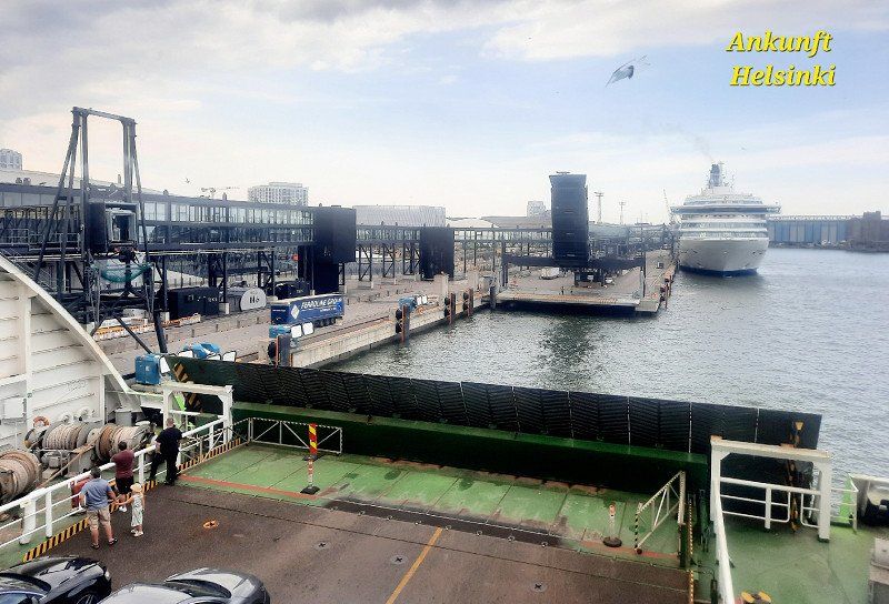
Helsinki
Arrival ferry
Hopefully took the dogs upstairs, although not allowed. Ours almost died in the hot car with the noise of the ship. Shock, injured, dehydrated, vet clinic and now don't want to drive anymore.
Finnland
60° 10' 11.5" N 24° 56' 18.2" E
60.1698557 24.9383790
• Head toward Simonkatu on Kaivokatu. Go for 8 m.
• Turn left onto Kaivokatu. Go for 407 m.
• Continue on Kaisaniemenkatu. Go for 459 m.
• Continue on Unioninkatu. Go for 229 m.
• Turn right onto Siltavuorenranta. Go for 530 m.
• Turn left onto Hakaniemen silta (4). Go for 1.4 km.
• Keep right onto Itäväylä (4/170) toward Itäkeskus/Östra Centrum/Lahti/Lahtis/Kotka/7/Kalasatama/Fiskehamnen. Go for 7.3 km.
• Turn right toward Meripellontie. Go for 433 m.
• Turn right onto Meripellontie. Go for 1.3 km.
• Continue on Vuotie. Go for 490 m.
• Take ramp. Go for 205 m.
• Turn left onto Karavaanisilta. Go for 120 m.
• Continue on Karavaanikatu. Go for 67 m.
• Turn right onto Karavaanikatu. Go for 62 m.
• Turn left onto Karavaanikatu. Go for 68 m.
• Make a U-Turn onto Karavaanikatu. Go for 82 m.
• Arrive at Karavaanikatu.
☍
13,2 km
( 21 min.)
Day
Rastila Camping
Unique and beautiful campsite. Albeit small paved parking spaces, but lawn, beach, playground, clean sanitary facilities and right next to the metro. 20 min €2.80/pers to town
Karavaanikatu 4, 00980, Helsinki, Finnland
60° 12' 24" N 25° 7' 16" E
60.2066700 25.1211100
• Head toward Karavaanikuja on Karavaanikatu. Go for 59 m.
• Turn left onto Karavaanikatu. Go for 67 m.
• Continue on Karavaanisilta. Go for 78 m.
• Turn right and take ramp onto Vuotie. Go for 692 m.
• Continue on Meripellontie. Go for 1.3 km.
• Turn left onto Itäväylä (170) toward Keskusta/Centrum. Go for 2.0 km.
• Keep left onto Itäväylä (170) toward Herttoniemi P./Hertonäs N./Keskusta/Centrum. Go for 7.4 km.
• Turn right onto Siltavuorenranta. Go for 530 m.
• Turn left onto Unioninkatu. Go for 203 m.
• Continue on Kaisaniemenkatu. Go for 274 m.
• Continue on Vilhonkatu. Go for 136 m.
• Turn left onto Rautatientori. Go for 160 m.
• Continue on Kaivokatu. Go for 364 m.
• Continue toward Kaivokatu. Go for 15 m.
• Arrive at Kaivokatu. Your destination is on the left.
☍
13,2 km
( 21 min.)
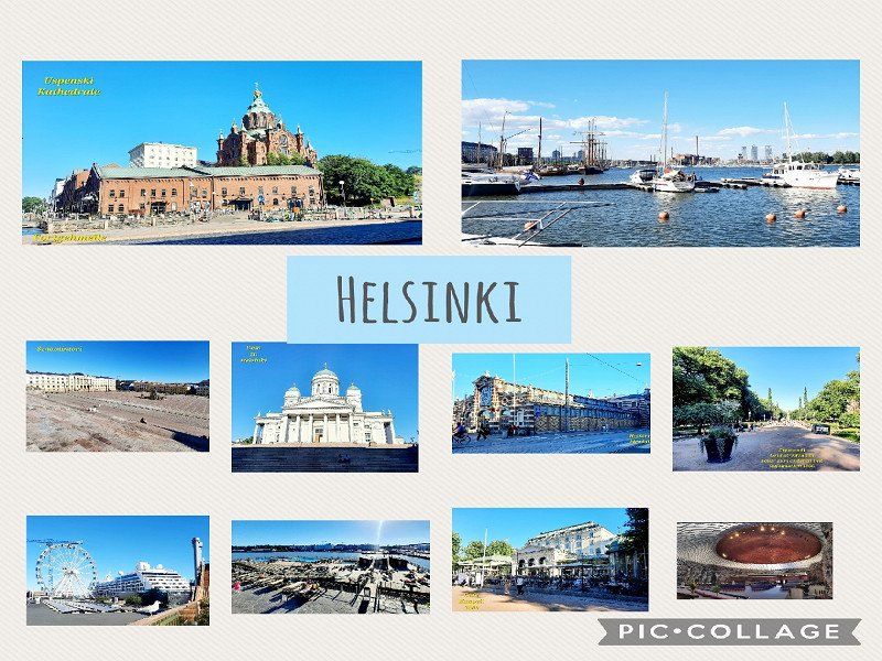
Helsinki
sightseeing. Can be done on foot. Duration approx. 2.5 hours
Finnland
60° 10' 11.5" N 24° 56' 18.2" E
60.1698557 24.9383790
• Head southwest.
• Arrive at Kaivokatu. Your destination is on the left.
☍
Distance not available
(Duration not available)
Day
Helsinki
Suomenlinna.
If you get the 24h ticket zone AB 8€/pers. You can also get to Museum Island by ferry. Runs every 20 minutes.
To save yourself a lot of meters, only visit the last island with the King's Gate and the cannons via the Main Gate. The rest has been disappointing.
Finnland
60° 10' 11.5" N 24° 56' 18.2" E
60.1698557 24.9383790
• Head toward Mannerheimintie on Simonkatu. Go for 3 m.
• Continue on Simonkatu. Go for 72 m.
• Make a U-Turn onto Simonkatu. Go for 77 m.
• Continue on Kaivokatu. Go for 407 m.
• Continue on Kaisaniemenkatu. Go for 459 m.
• Continue on Unioninkatu. Go for 229 m.
• Turn right onto Siltavuorenranta. Go for 530 m.
• Turn left onto Hakaniemen silta (4). Go for 1.4 km.
• Keep left onto Sörnäisten rantatie (45) toward Lentoasema/Flygplats/Tuusula/Tusby/1/Pasila/3/51/Böle. Go for 224 m.
• Turn left onto Lautatarhankatu (45) toward 1/Pasila/3/51/Böle/Lentoasema/Flygplats/Tuusula/Tusby. Go for 370 m.
• Turn right onto Hämeentie toward Kumpula/4/7/Gumtäkt. Go for 1.6 km.
• Continue on Kustaa Vaasan tie (E75) toward Lahti/Lahtis/Kotka/7. Go for 141 km.
• Continue on 5 (Valtatie 5) toward Mikkeli. Go for 123 km.
• Take ramp toward Savonlinna/Juva. Go for 350 m.
• Turn right onto Savonlinnantie (14) toward Savonlinna/Juva. Go for 203 m.
• Pass 4 roundabouts and continue on Rantasalmentie (14). Go for 62.1 km.
• Turn right onto Brahenkatu toward Keskusta. Go for 663 m.
• Take the 3rd exit from roundabout onto Olavinkatu. Go for 745 m.
• Arrive at Olavinkatu.
☍
333,3 km
(3 hrs. 39 min.)
Day
Savonlinna
Parking space at the parking lot directly at the lake
61.872056,28.825477
Finnland
61° 52' 6.2" N 28° 53' 10.2" E
61.8683766 28.8861803
• Head southeast.
• Arrive at Olavinkatu.
☍
Distance not available
(Duration not available)
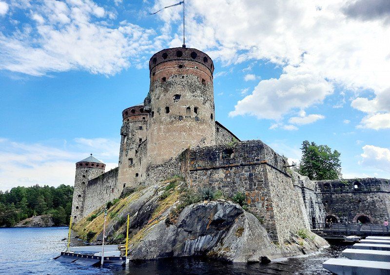
Savonlinna
Castle visit €12 entry/pers
Olavinlinna
Finnland
61° 52' 6.2" N 28° 53' 10.2" E
61.8683766 28.8861803
• Head toward Kauppatori on Olavinkatu. Go for 628 m.
• Turn left onto Savonlinnantie. Go for 268 m.
• Take the 1st exit from roundabout onto Savonlinnantie (14) toward Lappeenranta/Punkaharju/Kerimäki. Go for 3.5 km.
• Turn left onto Enonkoskentie (471) toward Heinävesi/Enonkoski/Lentoasema. Go for 162 m.
• Take the 2nd exit from roundabout onto Enonkoskentie (471). Go for 27.3 km.
• Arrive at Enonkoskentie (471). Your destination is on the right.
☍
31,9 km
( 28 min.)
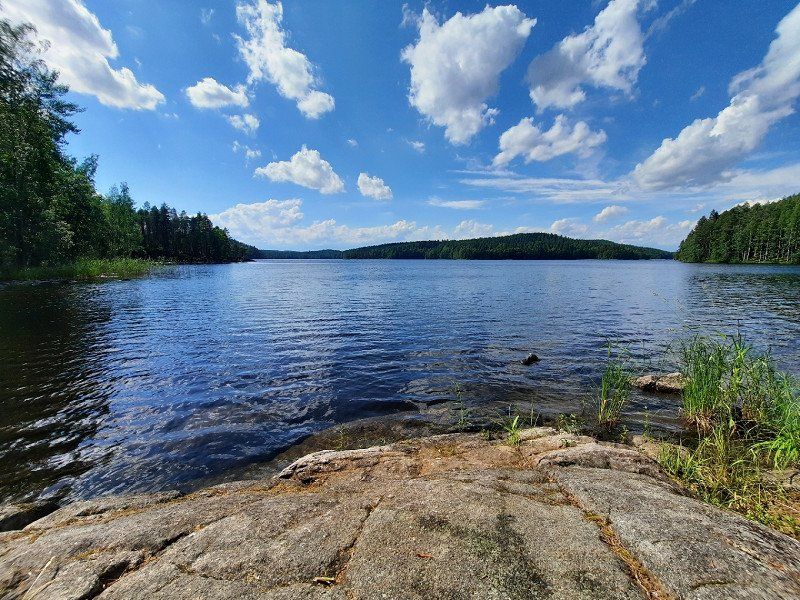
Enonkoski
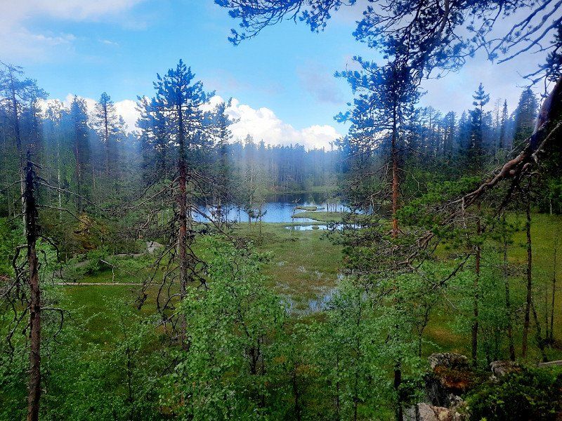
Nahkiaissalo Nature Trail
Near road 471
Beautiful hiking trail with bathing and barbecue area
Finnland
62° 5' 21.6" N 28° 54' 57.9" E
62.0893368 28.9160917
• Head north on Enonkoskentie (471). Go for 4.5 km.
• Turn right onto Hanhijärventie (15391). Go for 12.3 km.
• Turn left onto Luotojärventie (15394). Go for 10.9 km.
• Turn left onto Savonrannantie (474). Go for 31.8 km.
• Turn right onto Rönkönvaarantie (15415). Go for 8.1 km.
• Continue on Lammuntie (15644). Go for 9.6 km.
• Continue on Rönkönvaarantie (15644). Go for 2.1 km.
• Turn right onto Heinävedentie (476). Go for 18.2 km.
• Pass 2 roundabouts and continue on Liperintie (476). Go for 12.9 km.
• Turn right onto Kuopiontie (9) toward Joensuu. Go for 10.8 km.
• Take exit 24 toward Joensuu L/Käpykangas. Go for 331 m.
• Turn right onto Siltakatu (45503). Go for 1.6 km.
• Take the 2nd exit from roundabout onto Siltakatu (45503). Go for 447 m.
• Take the 3rd exit from roundabout onto Koulukatu (45504). Go for 207 m.
• Turn right onto Niskakatu. Go for 329 m.
• Turn right onto Torikatu. Go for 161 m.
• Arrive at Torikatu. Your destination is on the left.
☍
124,1 km
(1 hrs. 47 min.)
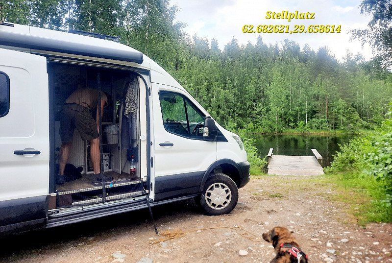
Joensuu
Parking space by the river
62.682621, 29.658614
Finnland
62° 36' 3.7" N 29° 45' 48.9" E
62.6010155 29.7635719
• Head southwest on Torikatu.
• Turn left onto Siltakatu. Go for 95 m.
• Take the 3rd exit from roundabout onto Rantakatu toward Rantakylä. Go for 349 m.
• Take the 2nd exit from roundabout onto Rantakatu toward Rantakylä. Go for 442 m.
• Turn left onto Rauhankatu. Go for 491 m.
• Take the 1st exit from roundabout onto Kajaanintie (45504). Go for 59.3 km.
• Turn right onto Kolintie (504) toward Koli/Lieksa. Go for 9.6 km.
• Continue on Merilänrannantie (504). Go for 13 m.
• Arrive at Merilänrannantie (504).
☍
70,3 km
( 52 min.)
Day
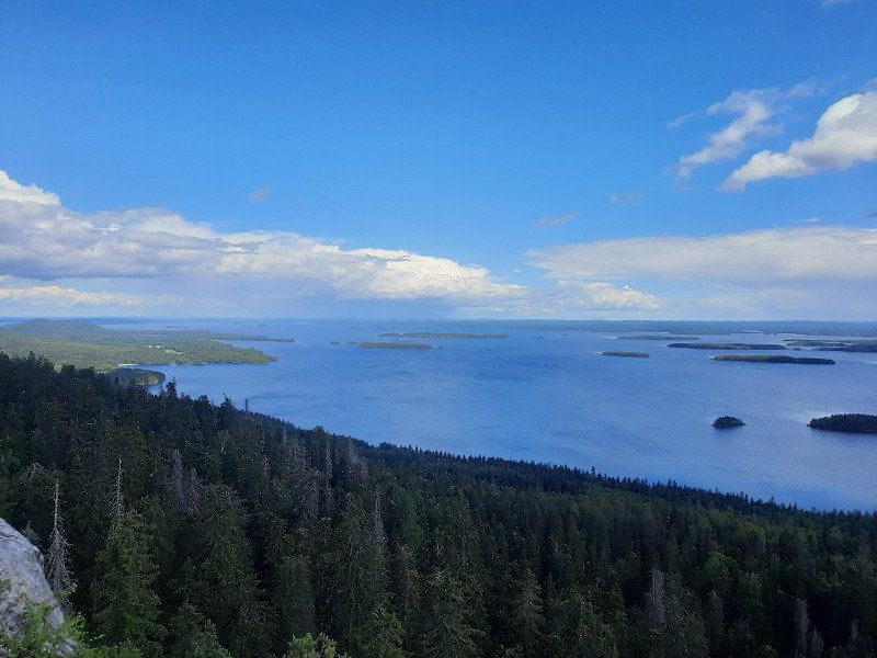
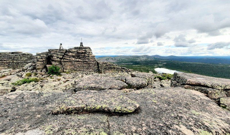
Koli
Akka Koli hill and two other rocks. 1.7km walk.
Hike with great views of the lakes
Parking and elevator free of charge.
High season mass tourism but also worth seeing.
Finnland
63° 6' 49.5" N 29° 46' 38.5" E
63.1137514 29.7773671
• Head toward Ylä-Kolintie on Merilänrannantie (504). Go for 13 m.
• Continue on Kolintie (504). Go for 9.6 km.
• Turn right onto Joensuuntie (6). Go for 130 km.
• Turn right onto 899 toward Sotkamo/Vuokatti. Go for 12.7 km.
• Turn left onto Vuokatintie (76). Go for 356 m.
• Turn right onto Pohjavaarantie (899). Go for 5.6 km.
• Turn right onto Naapurinvaarantie (9010). Go for 5.0 km.
• Continue on Kontiomäentie (9010). Go for 14.6 km.
• Continue on Sotkamontie (9010). Go for 2.3 km.
• Continue on Kontiomäentie (9010). Go for 1.1 km.
• Turn right onto Viitostie (E63) toward Kuusamo. Go for 79.4 km.
• Turn right onto Suomussalmentie (9151) toward Suomussalmi kk. Go for 4.1 km.
• Continue on Suomussalmentie (9150). Go for 1.7 km.
• Continue on Kainuuntie (9150). Go for 703 m.
• Turn left onto Salmentie (9150). Go for 1.0 km.
• Continue on Veikkolantie (9150). Go for 15.4 km.
• Turn right onto Viitostie (E63) toward Kuusamo. Go for 33.4 km.
• Arrive at Viitostie (E63). Your destination is on the right.
☍
317,3 km
(3 hrs. 36 min.)
Piispajärvi
Parking space in the parking lot with WW II monument
There must be a break after a 3-hour drive.
Finnland
65° 17' 49.6" N 29° 4' 26.4" E
65.2971118 29.0739953
• Head north on Viitostie (E63). Go for 84.2 km.
• Take the 2nd exit from roundabout onto Kemijärventie (E63) toward Lentoasema/Kemijärvi/Rovaniemi/Ruka. Go for 25.3 km.
• Turn right onto Rukatunturintie (8692) toward Ruka. Go for 119 m.
• Take the 2nd exit from roundabout onto Rukatunturintie (8692). Go for 209 m.
• Arrive at Rukatunturintie (8692).
☍
109,9 km
(1 hrs. 10 min.)
Day
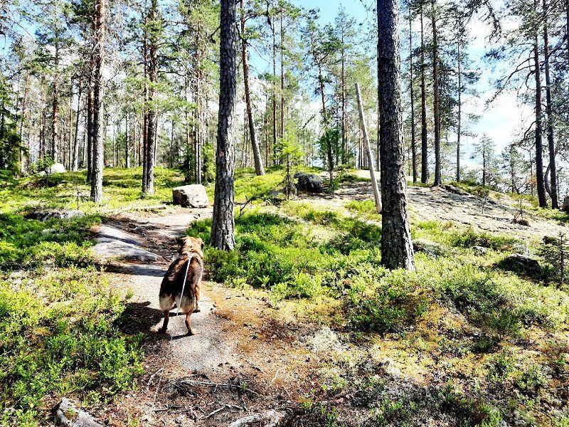
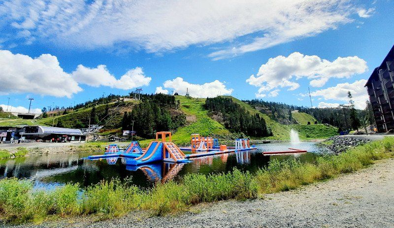
Ruka
Largest ski resort in Finland. Beautiful hiking trails, not too crowded in summer like Zakopane.
Everything for free, parking, hiking,...
Finnland
66° 9' 57.4" N 29° 7' 35.3" E
66.1659494 29.1264610
• Head east on Rukatunturintie (8692).
• Arrive at Rukatunturintie (8692).
☍
Distance not available
(Duration not available)
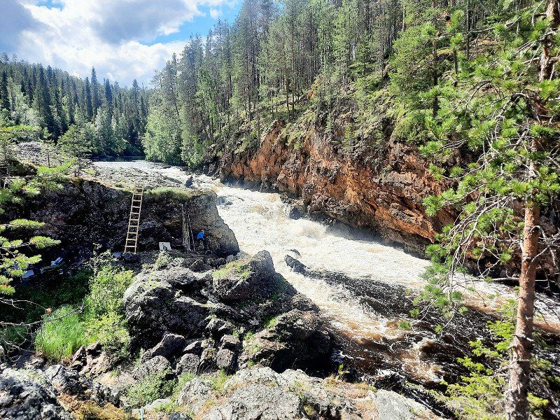
Ruka
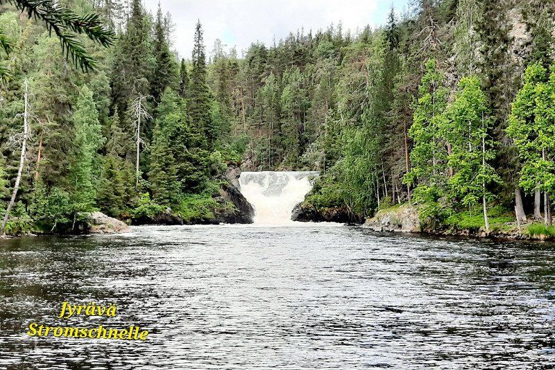
Oulanka National Park
Visit Kiutaköngä's rapids.
1.8km round trip. Parking and entry free.
Possibility to go longer tours from here.
Finnland
66° 9' 57.4" N 29° 7' 35.3" E
66.1659494 29.1264610
• Head east on Rukatunturintie (8692). Go for 5 m.
• Turn right onto Uunikulmantie. Go for 30 m.
• Turn right onto Riutanpää. Go for 69 m.
• Continue on Rukanriutta. Go for 140 m.
• Turn right onto Rukanriutta. Go for 22 m.
• Take the 3rd exit from roundabout onto Rukatunturintie (8692). Go for 172 m.
• Turn right onto Kemijärventie (E63). Go for 8.4 km.
• Turn right onto Juumantie (18897) toward Juuma. Go for 12.3 km.
• Continue on Riekamontie (18899). Go for 29 m.
• Arrive at Riekamontie (18899). Your destination is on the right.
☍
21,2 km
( 17 min.)
Juuma
Ala-Juuma Camping directly at the kl. Bear circuit 11km
20€ per night without electricity
Toilet, shower, kitchen, beach incl.
coffee next door
Sauna bookable
Finnland
66° 16' 14.1" N 29° 22' 59.8" E
66.2705831 29.3832830
• Head north on Riekamontie (18899).
• Arrive at Riekamontie (18899). Your destination is on the right.
☍
Distance not available
(Duration not available)
Day
Juuma
Small bear tour 12km, approx. 3h
Highly recommended. Best in the morning or evening, fewer people.
Don't forget mosquito protection.
Finnland
66° 16' 14.1" N 29° 22' 59.8" E
66.2705831 29.3832830
• Head toward Juumantie on Riekamontie (18899). Go for 29 m.
• Continue on Juumantie (18897). Go for 12.3 km.
• Turn right onto Kemijärventie (E63) toward Kemijärvi. Go for 109 km.
• Turn right onto Pelkosenniementie. Go for 2.3 km.
• Turn right onto Sodankyläntie (E63). Go for 7.1 km.
• Turn left onto Javaruksentie (9613) toward Javarus. Go for 48.0 km.
• Turn right onto Rovaniementie (E75). Go for 38.9 km.
• Take the 2nd exit from roundabout onto Sodankyläntie (E75) toward Ivalo. Go for 899 m.
• Take the 2nd exit from roundabout onto Ivalontie (E75) toward Ivalo. Go for 87.4 km.
• Turn left onto Pieranperä. Go for 118 m.
• Arrive at Pieranperä. Your destination is on the left.
☍
305,9 km
(3 hrs. 28 min.)
Vuotso
Stay overnight at the Pyhä-Nattanen hiking car park or do the 4km hike in 1h10min.
Lots of mosquitoes. Great view over the fell and the lakes.
A little further you can also go to Kiilopaa. Apparently there is a parking fee for overnight stays.
Finnland
68° 6' 8.2" N 27° 7' 12.2" E
68.1022806 27.1200497
• Head east on Pieranperä. Go for 118 m.
• Turn left onto Ivalontie (E75). Go for 71.1 km.
• Pass 3 roundabouts and continue on Ivalontie (E75). Go for 39.5 km.
• Arrive at Inarintie (E75). Your destination is on the right.
☍
110,7 km
(1 hrs. 14 min.)
Day
Inari
Lake Inari, 3rd largest lake in Finland
Hike to Jäniskoski rapids 0.5km. there are also longer hikes.
Possibility of boat excursion in Inari
Finnland
68° 54' 22.3" N 27° 1' 39.9" E
68.9062035 27.0277551
• Head toward Morottajanpolku on Inarintie (E75). Go for 24.8 km.
• Turn right onto Sevettijärventie (92) toward Kirkkoniemi/Kirkenes/Näätämö/Njávdám/Sevettijärvi/Cevetjävri. Go for 121 km.
• Continue on Finlandsveien (893). Go for 10.4 km.
• Turn left onto Bugøyfjordveien (E6) toward Alta. Go for 486 m.
• Turn right onto Mikkelsnesveien (8108) toward Mikkelsnes. Go for 119 m.
• Turn right onto Sandmoveien. Go for 191 m.
• Arrive at your destination.
☍
156,6 km
(1 hrs. 44 min.)
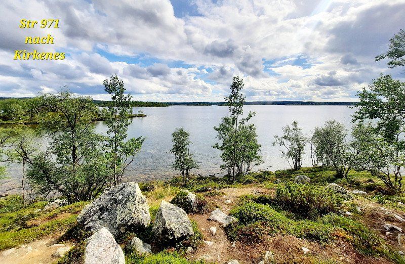
Neiden
Driving on the 971. Here you can already taste Norway. Loneliness, mountains, lakes, ...
Refueling at the border pays off. Cheaper than in Inari and Norway anyway.
Had no control at the border.
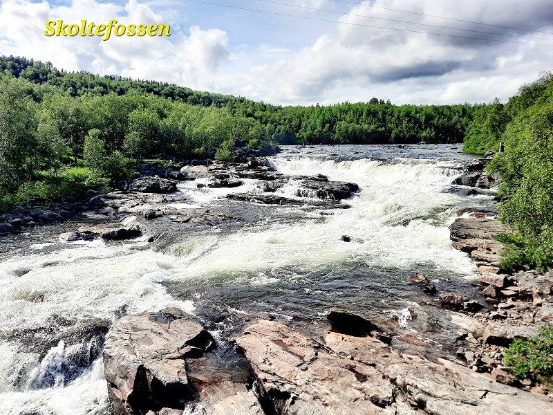
Visit to Skoltefossen
Stave Church is nice too.
Norwegen
69° 41' 37.8" N 29° 22' 52.9" E
69.6938332 29.3813677
• Head northeast. Go for 4 m.
• Turn slightly left onto Sandmoveien. Go for 187 m.
• Turn left onto Mikkelsnesveien (8108). Go for 119 m.
• Turn left onto Bugøyfjordveien (E6). Go for 486 m.
• Turn left onto Neidenveien (E6) toward Kirkenes. Go for 37.7 km.
• Pass 3 roundabouts and continue on E6. Go for 4.4 km.
• Take the 2nd exit from roundabout onto E6. Go for 111 m.
• Continue on Toppenveien (E6). Go for 44 m.
• Turn left onto Solheimsveien (E6). Go for 628 m.
• Turn right onto Kielland Torkildsens gate. Go for 32 m.
• Turn slightly left onto Kielland Torkildsens gate. Go for 169 m.
• Arrive at Kielland Torkildsens gate. Your destination is on the left.
☍
43,9 km
( 36 min.)
Kirkenes
Downtown doesn't really exist. Who wants to visit the bunker of the 2WW. daily 12:30 p.m., 20€
Norwegen
69° 43' 36.9" N 30° 2' 42.2" E
69.7269192 30.0450432
• Head toward Pasvikveien on Kielland Torkildsens gate. Go for 201 m.
• Turn left onto Solheimsveien (E6). Go for 628 m.
• Continue on Toppenveien (E6). Go for 44 m.
• Continue on E6. Go for 47 m.
• Continue toward E6. Go for 22 m.
• Pass 2 roundabouts and continue on E6. Go for 4.1 km.
• Take the 2nd exit from roundabout onto Bjørkheimveien (E105). Go for 2.4 km.
• Turn right onto Elvenesveien. Go for 1.8 km.
• Turn right toward Skafferhullet. Go for 402 m.
• Arrive at your destination.
☍
9,7 km
( 11 min.)
Elvenes
Russian border visited.
Norwegen
69° 40' 34.6" N 30° 6' 5.4" E
69.6762870 30.1014972
• Head toward Elvenesveien. Go for 402 m.
• Turn left onto Elvenesveien. Go for 1.8 km.
• Turn left onto E105. Go for 2.4 km.
• Take the 2nd exit from roundabout onto E6. Go for 339 m.
• Take the 2nd exit from roundabout onto E6 toward Lufthavn Alta. Go for 60.3 km.
• Arrive at Bugøyfjordveien (E6).
☍
65,2 km
( 50 min.)
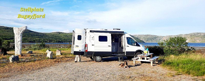
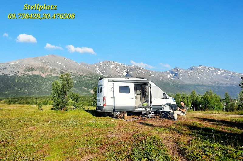
Bugøyfjord
Pitch by the sea, right by the monument.
Table available, silence, a bit stormy.
Norwegen
69° 52' 5.5" N 29° 20' 44.2" E
69.8681814 29.3456083
• Head north on Bugøyfjordveien (E6). Go for 58.3 km.
• Take the 1st exit from roundabout onto E75 toward Vardø. Go for 31.4 km.
• Continue on Nordvarangerveien (E75). Go for 455 m.
• Continue on E75. Go for 291 m.
• Continue on Nordvarangerveien (E75). Go for 2.5 km.
• Continue on E75. Go for 229 m.
• Continue on Nordvarangerveien (E75). Go for 5.1 km.
• Continue on E75. Go for 32 m.
• Continue on Nordvarangerveien (E75). Go for 3.3 km.
• Continue on E75. Go for 2.1 km.
• Continue on Nordvarangerveien (E75). Go for 1.9 km.
• Continue on E75. Go for 740 m.
• Continue on Tanavegen (E75). Go for 1.5 km.
• Continue on Havnegata (E75). Go for 889 m.
• Arrive at Havnegata (E75). Your destination is on the left.
☍
108,8 km
(1 hrs. 20 min.)
Day
Vadsø
Norwegen
70° 4' 28.2" N 29° 44' 53.2" E
70.0745056 29.7481181
• Head east on Havnegata (E75).
• Continue on Hvistendalsgate (E75). Go for 228 m.
• Take the 2nd exit from roundabout onto Hvistendalsgate (E75). Go for 953 m.
• Continue on Vardøvegen (E75). Go for 942 m.
• Continue on E75. Go for 2.0 km.
• Continue on Nordvarangerveien (E75). Go for 8.0 km.
• Continue on E75. Go for 1.6 km.
• Turn right onto Vestre Valen (8088). Go for 1.0 km.
• Arrive at Vestre Valen (8088). Your destination is on the right.
☍
14,8 km
( 14 min.)
Ekkerøy
Bunker, bird cliffs and beach
Norwegen
70° 4' 34.7" N 30° 6' 8.7" E
70.0762966 30.1024168
• Head toward Vestre Været on Vestre Valen (8088). Go for 6 m.
• Turn left onto Østre Været. Go for 48 m.
• Turn right onto Østre Været. Go for 28 m.
• Turn right onto Sondre Været. Go for 47 m.
• Turn right onto Vestre Været (8088). Go for 27 m.
• Turn slightly left onto Vestre Valen (8088). Go for 547 m.
• Turn slightly right toward E75. Go for 420 m.
• Turn right onto E75. Go for 4.5 km.
• Continue on Nordvarangerveien (E75). Go for 381 m.
• Continue on E75. Go for 118 m.
• Continue on Nordvarangerveien (E75). Go for 695 m.
• Continue on E75. Go for 52.2 km.
• Continue on Vardøtunnelen (E75). Go for 2.9 km.
• Continue on E75. Go for 228 m.
• Continue on Brodtkorbs gate. Go for 13 m.
• Turn left toward Kirkegata/8104. Go for 69 m.
• Turn right onto Kirkegata (8104). Go for 90 m.
• Turn left onto Strandgata (8104). Go for 12 m.
• Arrive at Strandgata (8104).
☍
62,3 km
( 47 min.)
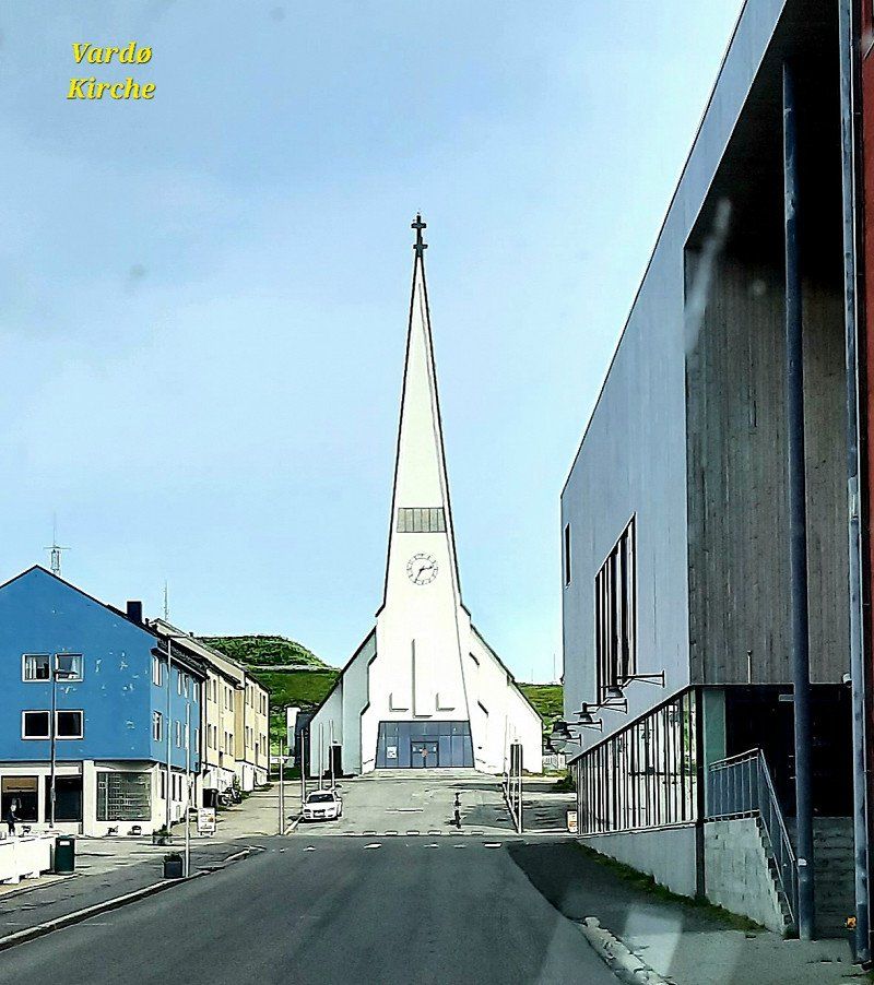
Vardø
nothing worth seeing
Norwegen
70° 22' 14.3" N 31° 6' 34.4" E
70.3706399 31.1095471
• Head north on Strandgata (8104). Go for 96 m.
• Turn right onto Grønvoldgata. Go for 62 m.
• Turn right onto Nordre Langgate. Go for 99 m.
• Turn right onto Kirkegata. Go for 50 m.
• Continue on Kristian 4 gate. Go for 64 m.
• Turn right onto Brodtkorbs gate. Go for 108 m.
• Continue on E75. Go for 228 m.
• Continue on Vardøtunnelen (E75). Go for 2.9 km.
• Continue on E75. Go for 579 m.
• Turn right onto 8100. Go for 3.1 km.
• Turn left. Go for 174 m.
• Turn slightly right. Go for 427 m.
• Turn right toward 8100. Go for 55 m.
• Turn left onto 8100. Go for 30.5 km.
• Turn right onto 8100. Go for 5.3 km.
• Turn right onto 8100. Go for 197 m.
• Arrive at 8100.
☍
43,9 km
(1 hrs. 3 min.)
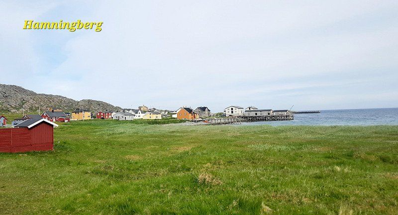
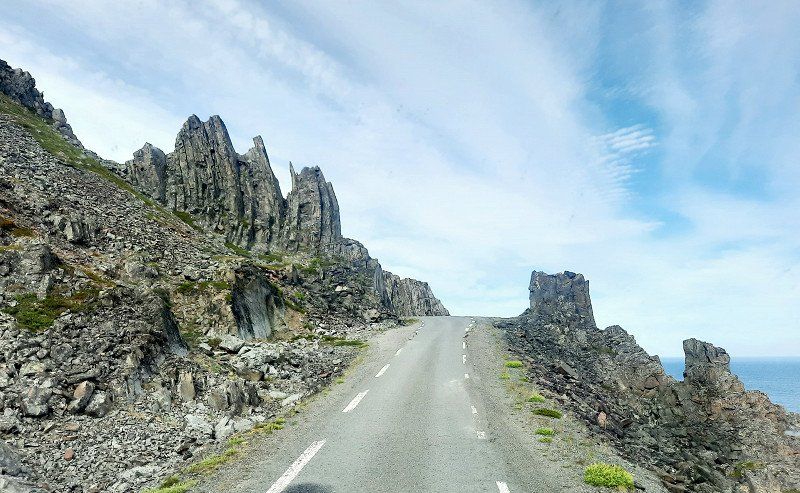
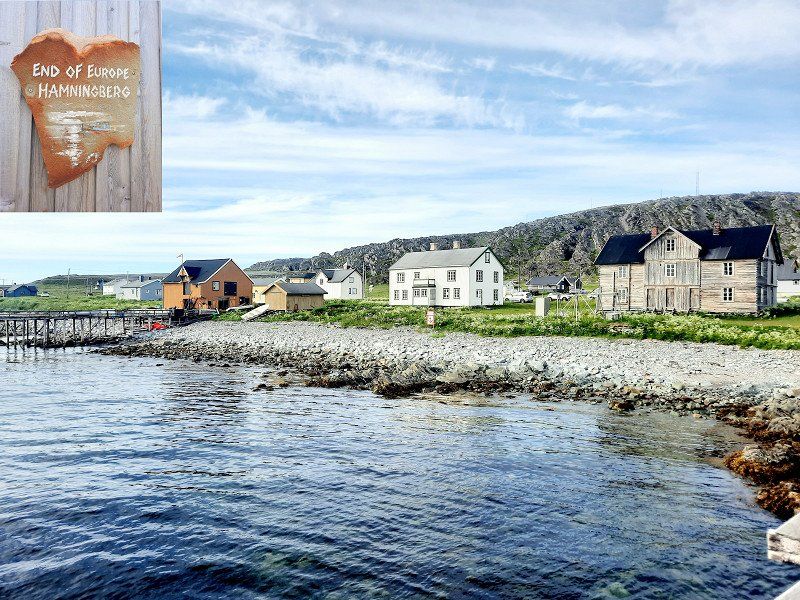
Hamningberg
end of Europe. Nice coffee house and, when the weather is nice, a nice pitch by the sea with a fireplace.
road very narrow. Watch out for oncoming traffic! 30km one way. Very nice rock formations and beach.
Norwegen
70° 32' 25.4" N 30° 36' 53.1" E
70.5403883 30.6147512
• Head northwest on 8100. Go for 197 m.
• Turn left onto 8100. Go for 4.5 km.
• Turn slightly left onto 8100. Go for 819 m.
• Turn left onto 8100. Go for 30.5 km.
• Turn right. Go for 55 m.
• Turn left. Go for 427 m.
• Turn sharp right. Go for 1.3 km.
• Turn left toward 8100. Go for 216 m.
• Turn right onto 8100. Go for 1.6 km.
• Turn right onto E75. Go for 51.7 km.
• Continue on Nordvarangerveien (E75). Go for 695 m.
• Continue on E75. Go for 118 m.
• Continue on Nordvarangerveien (E75). Go for 381 m.
• Continue on E75. Go for 6.4 km.
• Continue on Nordvarangerveien (E75). Go for 8.0 km.
• Continue on E75. Go for 2.0 km.
• Continue on Vardøvegen (E75). Go for 942 m.
• Continue on Hvistendalsgate (E75). Go for 922 m.
• Take the 2nd exit from roundabout onto Hvistendalsgate (E75). Go for 258 m.
• Continue on Havnegata (E75). Go for 889 m.
• Continue on Tanavegen (E75). Go for 1.5 km.
• Continue on E75. Go for 740 m.
• Continue on Nordvarangerveien (E75). Go for 1.9 km.
• Continue on E75. Go for 2.1 km.
• Continue on Nordvarangerveien (E75). Go for 3.3 km.
• Continue on E75. Go for 32 m.
• Continue on Nordvarangerveien (E75). Go for 5.1 km.
• Continue on E75. Go for 229 m.
• Continue on Nordvarangerveien (E75). Go for 2.5 km.
• Continue on E75. Go for 291 m.
• Continue on Nordvarangerveien (E75). Go for 455 m.
• Continue on E75. Go for 31.4 km.
• Take the 2nd exit from roundabout onto E6/E75. Go for 13.6 km.
• Turn left onto Polmakveien (895) toward Buolbmát/Polmak. Go for 18.5 km.
• Continue on 970. Go for 3.7 km.
• Turn right onto Tenontörmä. Go for 102 m.
• Turn slightly right onto Tenontörmä. Go for 27 m.
• Arrive at Tenontörmä. Your destination is on the right.
☍
197,4 km
(3 hrs. 11 min.)
Nuorgam
Pitch Pulmankijärventie 177, 99990 Utsjoki, Finland for Skaidijärvi Trail.
Went on because of the rain.
Finnland
70° 4' 55.5" N 27° 52' 18.4" E
70.0820900 27.8717749
• Head northwest on Tenontörmä. Go for 102 m.
• Turn right onto Tenontörmä. Go for 41 m.
• Turn slightly right onto Tenontörmä. Go for 113 m.
• Turn right onto Nuorgamintie (970). Go for 145 km.
• Turn right onto Norjantie (92). Go for 34 m.
• Arrive at Norjantie (92). Your destination is on the left.
☍
144,9 km
(1 hrs. 57 min.)
Day
Karigasniemi
Fill up and shop again.
Finnland
69° 23' 51.1" N 25° 51' 20.6" E
69.3975361 25.8557225
• Head west on Norjantie (92). Go for 508 m.
• Continue on Suomageaidnu (92). Go for 18.0 km.
• Enter the roundabout. Go for 43 m.
• Arrive at your destination on the left.
☍
18,6 km
( 16 min.)
Karasjok
Visit to the Sami Museum. Highly recommended.
Norwegen
69° 28' 19" N 25° 30' 38.9" E
69.4719350 25.5108130
• Follow the roundabout.
• Take the 1st exit from roundabout onto Kautokeinoveien (E6). Go for 307 m.
• Take the 2nd exit from roundabout onto Kautokeinoveien (92) toward Guovdageaidnu/Kautokeino. Go for 97.5 km.
• Turn right onto E45. Go for 97.3 km.
• Turn left onto Altaveien (E6) toward Narvik. Go for 157 km.
• Turn right onto Hovedvegen (E6). Go for 284 m.
• Turn right onto Hovedvegen (E6). Go for 44.9 km.
• Arrive at Olderdalsveien (E6). Your destination is on the right.
☍
397,7 km
(5 hrs. 27 min.)
Olderdalen
parking space
Great view of the fjord and the Lyngen Alps
69.633345,18.018500
Norwegen
69° 36' 14.6" N 20° 31' 57.8" E
69.6040650 20.5327207
• Head southeast on Olderdalsveien (E6).
• Arrive at Olderdalsveien (E6). Your destination is on the right.
☍
Distance not available
(Duration not available)
Day
Olderdalen
Ferry to Lyngseidet 160NOK
Norwegen
69° 36' 14.6" N 20° 31' 57.8" E
69.6040650 20.5327207
• Head southeast on Olderdalsveien (E6). Go for 217 m.
• Turn right onto Haugenvegen (91) toward Tromsø/Lyngseidet. Go for 259 m.
• Take the Lyngseidet-Olderdalen Ferry. Stay on for 12.8 km.
• Head northwest on 91. Go for 244 m.
• Turn right onto Kjosveien (91). Go for 21.1 km.
• Arrive at Ullsfjordveien (91).
☍
34,6 km
(1 hrs. 11 min.)
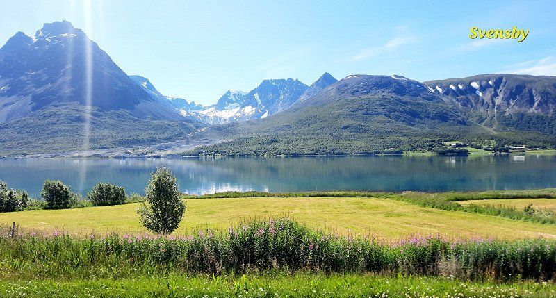
Svensby
Ferry to Breidvik 110 NOK
Norwegen
69° 39' 24.4" N 19° 49' 11.4" E
69.6567771 19.8198362
• Head north on Ullsfjordveien (91). Go for 866 m.
• Turn left onto 91. Go for 97 m.
• Take the Svensby-Breivikeidet Ferry. Stay on for 6.2 km.
• Head west on Breivikeidvegen (91). Go for 23.5 km.
• Turn right onto E8. Go for 22.0 km.
• Take the 3rd exit from roundabout onto Bruvegen (862). Go for 1.8 km.
• Turn left onto Skippergata. Go for 278 m.
• Turn right onto Bispegata. Go for 123 m.
• Turn left onto Grønnegata. Go for 358 m.
• Turn left onto Fredrik Langes gate. Go for 48 m.
• Arrive at Fredrik Langes gate. Your destination is on the right.
☍
55,2 km
(1 hrs. 25 min.)
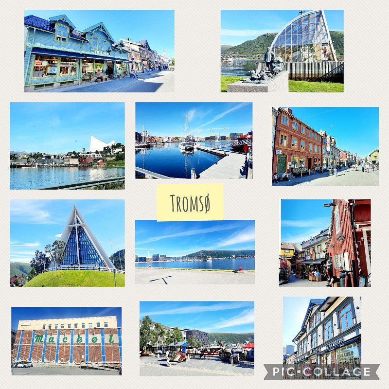
Tromsø
downtown and port. For the 2nd time and again very enthusiastic.
Arctic Cathedral and up the mountain to the view
Polar Museum was also interesting.
Norwegen
69° 38' 57.1" N 18° 57' 19.2" E
69.6492047 18.9553238
• Head toward Grønnegata on Fredrik Langes gate. Go for 139 m.
• Continue on Kongsbakken. Go for 147 m.
• Continue on Kirkegårdsvegen. Go for 1.0 km.
• Turn slightly left onto Langnesvegen. Go for 1.9 km.
• Take the 1st exit from roundabout onto Kvaløyvegen (63). Go for 352 m.
• Take the 2nd exit from roundabout onto Kvaløyvegen (862/63). Go for 299 m.
• Take the 3rd exit from roundabout onto Kvaløyvegen (862). Go for 1.1 km.
• Pass 6 roundabouts and continue on Eidvegen (862). Go for 8.7 km.
• Turn right onto Fjordvegen (862). Go for 4.2 km.
• Turn left onto 862. Go for 380 m.
• Continue on Kattfjordeidet (862). Go for 11.1 km.
• Continue on 862. Go for 187 m.
• Turn left onto Synnøvjordvegen (862). Go for 5.6 km.
• Continue on Sjøtunvegen (862). Go for 6.7 km.
• Continue on Sandneshamnvegen (862). Go for 10.4 km.
• Turn right onto Brensholmvegen (7766). Go for 2.4 km.
• Continue on 7766. Go for 648 m.
• Continue on Hillesøyvegen (7766). Go for 1.5 km.
• Turn right onto Nordjordvegen. Go for 211 m.
• Arrive at Nordjordvegen.
☍
57,1 km
(1 hrs. 5 min.)
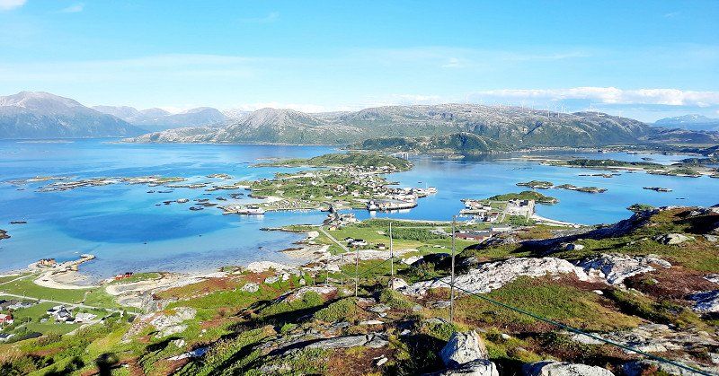
Sommarøy
Sightseeing Peninsula
beautiful beaches
Great view from Hillesøy, 190hm, 700m
Parking space next to the road on the beach
69.633345,18.018500
Sommarøy, Norwegen
69° 38' 28.6" N 18° 1' 58.8" E
69.6412838 18.0330002
• Head west on Nordjordvegen. Go for 211 m.
• Turn left onto Hillesøyvegen (7766). Go for 1.5 km.
• Continue on 7766. Go for 648 m.
• Continue on Brensholmvegen (7766). Go for 3.8 km.
• Arrive at Brensholmvegen (862). Your destination is on the right.
☍
6,2 km
( 9 min.)
Day
Brensholmen
Ferry to Senja 248 NOK
Norwegen
69° 36' 5" N 18° 2' 51.3" E
69.6013934 18.0475802
• Head southwest on Brensholmvegen (862).
• Turn right onto Salvegen (862). Go for 762 m.
• Turn right onto 862. Go for 62 m.
• Continue on 862. Go for 136 m.
• Turn slightly left onto 862. Go for 210 m.
• Take the Brensholmen-Botnhamn Ferry. Stay on for 13.7 km.
• Head southwest on 862. Go for 221 m.
• Arrive at 862. Your destination is on the left.
☍
15,0 km
( 52 min.)
Botnhamn
ferry
Norwegen
69° 30' 26.8" N 17° 54' 10.5" E
69.5074434 17.9029236
• Head west on 862.
• Turn left onto 862. Go for 138 m.
• Continue on Botnhamnveien (862). Go for 724 m.
• Continue on 862. Go for 24 m.
• Continue on Botnhamnveien (862). Go for 2.5 km.
• Continue on 862. Go for 63 m.
• Continue on Breidablikk (862). Go for 98 m.
• Continue on 862. Go for 452 m.
• Continue on Botnhamnveien (862). Go for 3.5 km.
• Turn slightly right toward 862. Go for 36 m.
• Turn left toward 861. Go for 15 m.
• Continue on Stønesbotnveien (861). Go for 3.6 km.
• Continue on 861. Go for 8 m.
• Continue on Stønesbotnveien (861). Go for 336 m.
• Continue on 861. Go for 70 m.
• Continue on Stønesbotnveien (861). Go for 4.0 km.
• Continue on Lysnesveien (861). Go for 2.0 km.
• Continue on 861. Go for 457 m.
• Continue on Lysnesveien (861). Go for 461 m.
• Continue on 861. Go for 101 m.
• Continue on Lysnesveien (861). Go for 2.6 km.
• Continue on 861. Go for 298 m.
• Continue on Lysnesveien (861). Go for 1.7 km.
• Continue on 861. Go for 206 m.
• Continue on Lysnesveien (861). Go for 536 m.
• Continue on 861. Go for 157 m.
• Continue on Lysnesveien (861). Go for 752 m.
• Continue on 861. Go for 214 m.
• Continue on Lysnesveien (861). Go for 4.0 km.
• Continue on Skolebakken (861). Go for 81 m.
• Turn right onto 861. Go for 959 m.
• Continue on Landøyveien (861). Go for 1.5 km.
• Continue on 861. Go for 410 m.
• Continue on Skognesveien (861). Go for 405 m.
• Continue on 861. Go for 1.1 km.
• Continue on Skognesveien (861). Go for 646 m.
• Continue on 861. Go for 121 m.
• Continue on Skognesveien (861). Go for 248 m.
• Continue on 861. Go for 83 m.
• Continue on Skognesveien (861). Go for 182 m.
• Continue on 861. Go for 126 m.
• Continue on Skognesveien (861). Go for 115 m.
• Continue on 861. Go for 357 m.
• Continue on Skognesveien (861). Go for 174 m.
• Continue on 861. Go for 198 m.
• Continue on Skognesveien (861). Go for 844 m.
• Continue on 861. Go for 99 m.
• Continue on Skognesveien (861). Go for 358 m.
• Continue on 861. Go for 595 m.
• Continue on Skognesveien (861). Go for 906 m.
• Continue on 861. Go for 167 m.
• Continue on Skognesbotn (861). Go for 84 m.
• Continue on 861. Go for 156 m.
• Continue on Skognesveien (861). Go for 679 m.
• Continue on 861. Go for 82 m.
• Continue on Skognesveien (861). Go for 279 m.
• Continue on 861. Go for 412 m.
• Continue on Skognesveien (861). Go for 271 m.
• Continue on 861. Go for 341 m.
• Continue on Grasmyrveien (861). Go for 568 m.
• Continue on 861. Go for 1.1 km.
• Continue on Grasmyrveien (861). Go for 724 m.
• Continue on 861. Go for 43 m.
• Continue on Grasmyrveien (861). Go for 1.6 km.
• Continue on Vikaveien (861). Go for 107 m.
• Continue on 861. Go for 308 m.
• Continue on Vikaveien (861). Go for 272 m.
• Continue on 861. Go for 178 m.
• Continue on Vikaveien (861). Go for 848 m.
• Continue on 861. Go for 670 m.
• Continue on Vikaveien (861). Go for 370 m.
• Continue on 861. Go for 85 m.
• Continue on Vikaveien (861). Go for 1.1 km.
• Continue on 861. Go for 175 m.
• Continue on Vikaveien (861). Go for 254 m.
• Continue on 861. Go for 59 m.
• Continue on Vikaveien (861). Go for 1.7 km.
• Turn left onto 86. Go for 1.3 km.
• Continue on Strandveien (86). Go for 845 m.
• Turn left onto Larsbakken. Go for 150 m.
• Turn slightly right onto Nygårdsveien. Go for 115 m.
• Continue on Smørhusbakken. Go for 54 m.
• Turn left onto Knausen. Go for 118 m.
• Arrive at Knausen. Your destination is on the left.
☍
53,8 km
(1 hrs. 13 min.)
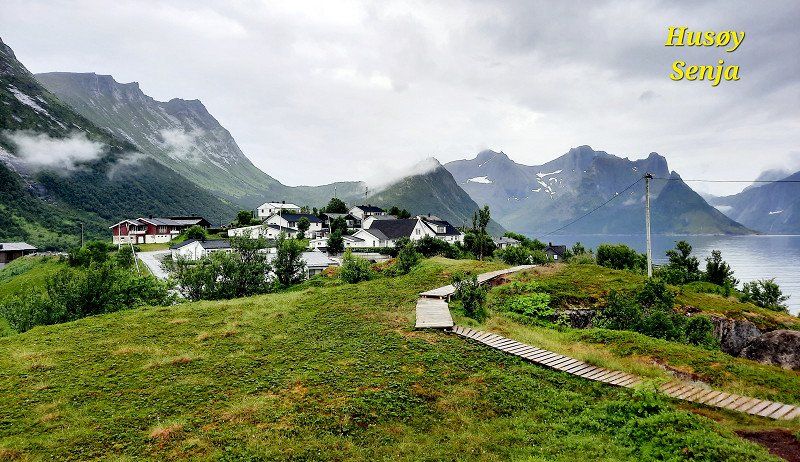
Husøy
The Riven Head Trail was canceled due to rain. The mountains were covered in clouds. No distant view.
But visited Husøy and the lighthouse. Oh well.
Finnsnes
waypoint
Norwegen
69° 13' 55.3" N 17° 58' 51.1" E
69.2320380 17.9808555
• Head toward Liaveien on Knausen. Go for 86 m.
• Turn right onto Liaveien. Go for 117 m.
• Turn right onto Skolegata. Go for 388 m.
• Turn slightly left onto Storgata (86). Go for 938 m.
• Continue on 86. Go for 3.4 km.
• Continue on 855. Go for 29.9 km.
• Turn right onto E6. Go for 4.8 km.
• Pass 6 roundabouts and continue on Nordmoveien (E6). Go for 89.6 km.
• Arrive at Nordmoveien (E6/E10).
☍
129,3 km
(1 hrs. 47 min.)
Bjerkvik
waypoint
Norwegen
68° 32' 58" N 17° 33' 27.1" E
68.5494315 17.5575146
• Head south on Nordmoveien (E6/E10). Go for 19 m.
• Take the 1st exit from roundabout onto Kong Olavs vei (E10). Go for 60.5 km.
• Take the 2nd exit from roundabout onto Tjeldsundveien (E10) toward Sortland/Lødingen/Å i Lofoten. Go for 48.3 km.
• Turn right onto Kong Olavs vei (E10). Go for 18.1 km.
• Take the 3rd exit from roundabout onto E10. Go for 28.2 km.
• Turn left onto 7630. Go for 857 m.
• Continue on Steinbakken (7630). Go for 102 m.
• Continue on 7630. Go for 5.6 km.
• Continue on Raftstranda Nordre (7630). Go for 101 m.
• Continue on 7630. Go for 429 m.
• Continue on Raftstranda Søndre (7630). Go for 99 m.
• Continue on 7630. Go for 1.7 km.
• Arrive at 7630. Your destination is on the left.
☍
164,1 km
(2 hrs. 18 min.)
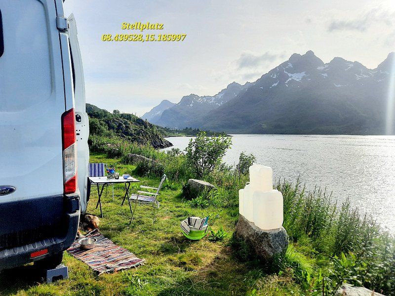
Raften
Parking space nearby
Away from E10, beautiful view of the fjord.
68.439504,15.186087
Norwegen
68° 23' 49" N 15° 7' 59.1" E
68.3969456 15.1330765
• Head north on 7630. Go for 1.7 km.
• Continue on Raftstranda Søndre (7630). Go for 99 m.
• Continue on 7630. Go for 429 m.
• Continue on Raftstranda Nordre (7630). Go for 101 m.
• Continue on 7630. Go for 5.6 km.
• Continue on Steinbakken (7630). Go for 102 m.
• Continue on 7630. Go for 857 m.
• Turn left onto E10. Go for 51.4 km.
• Take the 1st exit from roundabout onto Kong Olavs vei (E10). Go for 23.8 km.
• Turn right onto Brennaveien (7628). Go for 2.3 km.
• Arrive at Brennaveien (7628).
☍
86,4 km
(1 hrs. 18 min.)
Day
Rystad lofoten camping
Best campsite ever for price/quality/view in the mass tourism areas of Norway.
280NOK without electricity. dogs free. shower, kitchen, waste water. drinking water incl.
Washing machine/dryer 20NOK/50 min
Everything clean, very informal and friendly. Everyone cleans the dishes after themselves, uses toilet brooms and is considerate.
Thanks to the pouring rain used the whole day as a washing day.
Brennaveien 235, 8313, Kleppstad, Norwegen
68° 16' 34" N 14° 18' 7" E
68.2761100 14.3019400
• Head southwest on Brennaveien (7628). Go for 2.3 km.
• Turn left onto Kleppstadveien (E10). Go for 8.3 km.
• Turn right onto Henningsværveien (816). Go for 7.3 km.
• Turn slightly right onto Henningsværveien (816). Go for 109 m.
• Continue on Henningsværveien (816). Go for 245 m.
• Turn right onto Dreyers gate. Go for 30 m.
• Turn left onto Dreyers gate. Go for 196 m.
• Turn slightly right toward Dreyers gate. Go for 96 m.
• Turn right onto Dreyers gate. Go for 265 m.
• Continue on Hellandsgata. Go for 500 m.
• Arrive at Hellandsgata.
☍
19,4 km
( 24 min.)
Day
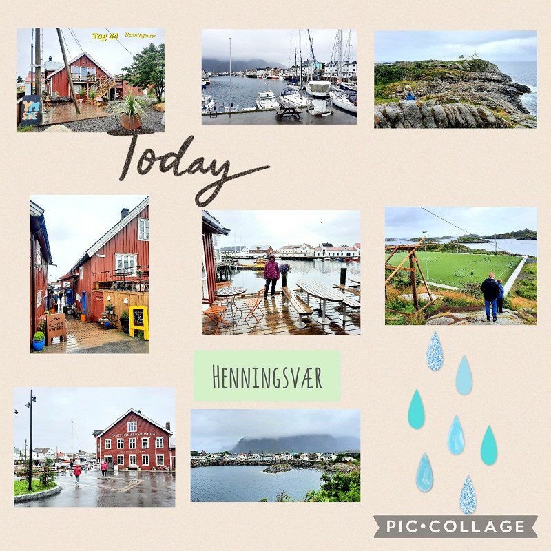
Henningsvær
City tour including soccer field
Viewpoint not hiked due to rain.
Norwegen
68° 9' 15.1" N 14° 12' 26.1" E
68.1541872 14.2072535
• Head toward Ole Juuls gate on Hellandsgata. Go for 500 m.
• Continue on Dreyers gate. Go for 340 m.
• Turn left onto Dreyers gate. Go for 17 m.
• Turn right onto Dreyers gate. Go for 226 m.
• Turn left onto Henningsværveien (816). Go for 7.7 km.
• Turn right onto Kong Olavs vei (E10). Go for 15.4 km.
• Take the 3rd exit from roundabout onto Kong Olavs vei (E10). Go for 79.5 km.
• Take the 1st exit from roundabout onto Kong Olavs vei (E10). Go for 18.2 km.
• Turn right onto 85. Go for 2.0 km.
• Continue on Sjøvegen (7546). Go for 1.4 km.
• Turn slightly right onto Strandvegen (7546). Go for 404 m.
• Turn left onto Molovegen. Go for 463 m.
• Arrive at Molovegen. Your destination is on the right.
☍
126,2 km
(1 hrs. 53 min.)
Lødingen
After 7 days of continuous rain are announced on the west coast, Norway is canceled and driven to central Sweden. The Lofoten rained for the 2nd time. Wonder if there are even more than 2 days of sun in a row here.
Lødingen, Norwegen
68° 24' 43.1" N 16° 0' 34.5" E
68.4119794 16.0095913
• Head toward Strandvegen on Molovegen. Go for 463 m.
• Turn right onto Strandvegen (7546). Go for 340 m.
• Turn slightly left onto Strandvegen (7546). Go for 64 m.
• Turn slightly left onto Sjøvegen (7546). Go for 529 m.
• Turn slightly right onto Sjøvegen (7546). Go for 432 m.
• Continue on Sjøvegen (7546). Go for 356 m.
• Turn slightly left onto Sjøvegen (7546). Go for 85 m.
• Turn right onto 85. Go for 312 m.
• Take the Lødingen-Bognes Ferry. Stay on for 23.3 km.
• Head toward Storjord E6 on 85. Go for 257 m.
• Turn right onto Storjord E6 (E6). Go for 46.7 km.
• Take the 2nd exit from roundabout onto Hamarøyveien (E6). Go for 41.7 km.
• Turn right onto 613. Go for 18 m.
• Turn sharp right onto Sildhopen. Go for 345 m.
• Arrive at Sildhopen. Your destination is on the left.
☍
114,9 km
(2 hrs. 29 min.)
Mørsvikbotn
67.726715,15.912899 Pitch near the lake and tables
Norwegen
67° 41' 32.2" N 15° 50' 29.4" E
67.6922914 15.8414920
• Head southeast on Sildhopen. Go for 345 m.
• Turn sharp left onto 613. Go for 18 m.
• Turn right onto E6. Go for 75.2 km.
• Take the 3rd exit from roundabout onto Storgaten (E6) toward Trondheim. Go for 424 m.
• Take the 2nd exit from roundabout onto Storgaten (E6) toward Trondheim. Go for 173 km.
• Take the 2nd exit from roundabout onto Selforsveien (E6) toward Mo i Rana. Go for 265 m.
• Pass 2 roundabouts and continue on E6. Go for 1.2 km.
• Take the 1st exit from roundabout onto Skansen toward Nordlandsv. Go for 208 m.
• Take the 2nd exit from roundabout onto Nordlandsveien. Go for 584 m.
• Continue on Lars Meyers gate. Go for 181 m.
• Turn right onto Skolegata. Go for 99 m.
• Turn left onto Lensmann Hansens gate. Go for 128 m.
• Arrive at Lensmann Hansens gate. Your destination is on the left.
☍
251,9 km
(3 hrs. 21 min.)
Day
Mo i Rana
If the weather would be nice, it pays to visit the Svartisen Glacier. Worth seeing.
Norwegen
66° 18' 49.4" N 14° 8' 31.1" E
66.3137122 14.1419749
• Head toward Skoginspektør Nilsens vei on Lensmann Hansens gate. Go for 39 m.
• Turn right onto Skoginspektør Nilsens vei. Go for 143 m.
• Turn right onto Skolegata. Go for 128 m.
• Turn left onto Lars Meyers gate. Go for 181 m.
• Continue on Nordlandsveien. Go for 533 m.
• Take the 2nd exit from roundabout onto Skansen. Go for 217 m.
• Take the 2nd exit from roundabout onto E6. Go for 982 m.
• Take the 1st exit from roundabout onto E12 toward Umeå. Go for 38.8 km.
• Continue on Blå vägen (E12). Go for 79.8 km.
• Arrive at Blå vägen (E12).
☍
120,7 km
(1 hrs. 38 min.)
Tärnafors
Since the weather is still bad, we only take a 4km walk to stretch our legs.
Tärnaåleden Trail
There is also a nice Gurkfjäll hike with a view nearby.
Gamla kyets kapell pitch. Calm and lonely.
Schweden
65° 42' 45.6" N 15° 21' 29.4" E
65.7126761 15.3581550
• Head southeast on Blå vägen (E12). Go for 44.1 km.
• Turn right toward Kittelfjäll/Dikanäs/Umnäs. Go for 3.4 km.
• Continue on Hällnäs. Go for 3.7 km.
• Continue on Umnäs. Go for 5.6 km.
• Turn right toward Morka. Go for 6.1 km.
• Continue on Morka. Go for 1.9 km.
• Turn right toward Silverberg. Go for 109 m.
• Continue on Silverberg. Go for 2.0 km.
• Continue on Sjöberg. Go for 2.3 km.
• Continue on Sjöberg. Go for 624 m.
• Continue on Skansnäs. Go for 2.6 km.
• Continue on Skansnäs. Go for 7.7 km.
• Continue on Björkenäs. Go for 2.1 km.
• Continue on Skansnäsvägen. Go for 3.2 km.
• Turn left onto Dikanäsvägen. Go for 3.0 km.
• Turn right onto Sagavägen. Go for 6.0 km.
• Continue on Lillsutsberg. Go for 2.9 km.
• Continue on Sagavägen. Go for 3.2 km.
• Continue on Atjiken. Go for 3.8 km.
• Continue on Eriksberg. Go for 24.9 km.
• Turn left onto Sagavägen. Go for 18.1 km.
• Turn right onto Granliden. Go for 12.0 km.
• Continue on Brännåker. Go for 7.8 km.
• Continue on Västra Granberget. Go for 2.2 km.
• Continue on Västra Granberget. Go for 3.2 km.
• Turn left toward Långselevägen. Go for 7.1 km.
• Continue on Långselevägen. Go for 4.7 km.
• Continue on Bredsele. Go for 6.5 km.
• Continue on Västra Ormsjö. Go for 11.0 km.
• Continue on Västra Ormsjö. Go for 927 m.
• Continue on Västra Ormsjö. Go for 1.6 km.
• Continue on Östra Ormsjö. Go for 1.8 km.
• Continue on Östra Ormsjö. Go for 600 m.
• Continue on Östra Ormsjö. Go for 314 m.
• Continue on Östra Ormsjö. Go for 1.4 km.
• Continue on Barnäs. Go for 3.9 km.
• Continue on Tvåtjärn. Go for 5.0 km.
• Continue on Avaträsk. Go for 428 m.
• Continue on Avaträsk. Go for 266 m.
• Continue on Avaträsk. Go for 137 m.
• Continue on Avaträsk. Go for 438 m.
• Continue on Avaträsk. Go for 336 m.
• Continue on Avaträsk. Go for 185 m.
• Continue on Avaträsk. Go for 1.6 km.
• Continue on Avaträsk. Go for 339 m.
• Continue on Avaträsk. Go for 3.2 km.
• Continue on Västra Nyhem. Go for 1.7 km.
• Continue on Östra Nyhem. Go for 2.9 km.
• Continue on Åbron. Go for 481 m.
• Turn right onto E45. Go for 70.1 km.
• Pass 2 roundabouts and continue on Brogatan (E45). Go for 96.3 km.
• Turn left and take ramp onto E14/E45 toward Sundsvall/Mora/Odenskog. Go for 18.3 km.
• Take the 1st exit from roundabout onto E45 toward Mora/Svenstavik/Viken. Go for 168 km.
• Turn right onto Ljusnegatan (84) toward Röros/Funäsdalen. Go for 179 m.
• Turn left onto Härjedalsgatan. Go for 319 m.
• Arrive at Härjedalsgatan. Your destination is on the left.
☍
581,9 km
(7 hrs. 9 min.)
Day
Sveg
Pitch 62.034074,14.279071
Schweden
62° 2' 4.6" N 14° 21' 32.5" E
62.0346245 14.3590366
• Head toward Jämtlandsgatan on Härjedalsgatan. Go for 319 m.
• Turn right onto Ljusnegatan (84). Go for 124 km.
• Pass 3 roundabouts and continue on E45. Go for 12.5 km.
• Take the 3rd exit from roundabout onto 70 toward Enköping. Go for 1.1 km.
• Pass 2 roundabouts and continue on Riksvägen (70). Go for 33.5 km.
• Take the 3rd exit from roundabout onto Centralgatan (301) toward Edsbyn/Furudal. Go for 551 m.
• Take the 4th exit from roundabout. Go for 152 m.
• Continue on Backavägen. Go for 85 m.
• Turn left onto Höök Olles väg. Go for 43 m.
• Arrive at Höök Olles väg. Your destination is on the left.
☍
171,8 km
(2 hrs. )
Day
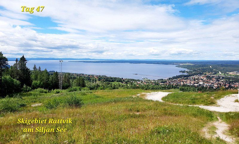
Rättvik
Hike in the panoramic mountain ski area
There is also a summer toboggan run
Schweden
60° 53' 20.5" N 15° 7' 24.1" E
60.8890250 15.1233730
• Head toward Backavägen on Höök Olles väg. Go for 43 m.
• Turn right onto Backavägen. Go for 149 m.
• Take the 3rd exit from roundabout onto Vasagatan. Go for 576 m.
• Take the 2nd exit from roundabout onto Riksvägen (70). Go for 494 m.
• Take the 1st exit from roundabout onto Riksvägen (70) toward 69/Falun/Enköping. Go for 8.7 km.
• Turn right onto Tällbergsvägen toward Tällberg. Go for 1.1 km.
• Continue on Plintsberg Tällbergsvägen. Go for 279 m.
• Continue on Plintsberg Plintsbergsvägen. Go for 85 m.
• Continue on Plintsberg Tällbergsvägen. Go for 107 m.
• Continue on Plintsberg Tällbergsvägen. Go for 769 m.
• Continue on Tällbergsvägen. Go for 1.0 km.
• Turn slightly right onto Tällbergsvägen. Go for 288 m.
• Arrive at Tällbergsvägen. Your destination is on the left.
☍
13,7 km
( 13 min.)
Tällberg
Hike at the lake, near the campsite
Visit of the beautiful old wooden houses
Schweden
60° 49' 34" N 14° 59' 31.5" E
60.8260976 14.9920858
• Head east on Tällbergsvägen. Go for 1.3 km.
• Continue on Plintsberg Tällbergsvägen. Go for 772 m.
• Continue on Plintsberg Tällbergsvägen. Go for 104 m.
• Continue on Plintsberg Plintsbergsvägen. Go for 85 m.
• Continue on Plintsberg Tällbergsvägen. Go for 279 m.
• Continue on Tällbergsvägen. Go for 1.1 km.
• Turn right onto 70. Go for 9.9 km.
• Turn right onto Leksandsvägen toward Sågmyra/Leksand C/Tällberg. Go for 854 m.
• Turn left onto Faluvägen. Go for 123 m.
• Turn right onto Hantverkaregatan. Go for 155 m.
• Arrive at Hantverkaregatan. Your destination is on the right.
☍
14,7 km
( 13 min.)
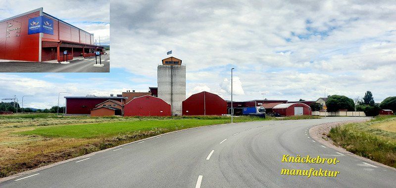
Leksand
Visit to the crispbread factory
Schweden
60° 43' 49.1" N 14° 59' 59.6" E
60.7303082 14.9998922
• Head south on Hantverkaregatan.
• Turn left onto Norsgatan. Go for 73 m.
• Turn left onto Hagagatan. Go for 150 m.
• Turn left onto Faluvägen. Go for 229 m.
• Turn right onto Leksandsvägen. Go for 854 m.
• Turn right onto 70. Go for 23.7 km.
• Take the 2nd exit from roundabout onto E16 toward Gävle/Enköping. Go for 528 m.
• Pass 6 roundabouts and continue on Tjärnavägen (E16). Go for 19.1 km.
• Take the 2nd exit from Backarondellen roundabout onto Bergslagsdiagonalen (E16) toward Gävle/Falun/Enköping. Go for 1.1 km.
• Take the 2nd exit from Åkrerondellen roundabout onto Bergslagsdiagonalen (E16) toward Gävle/Falun. Go for 608 m.
• Turn right onto 70. Go for 1.1 km.
• Take the 2nd exit from roundabout onto 70 toward Enköping. Go for 1.3 km.
• Take the 3rd exit from roundabout onto 70 toward Enköping. Go for 22.1 km.
• Pass 3 roundabouts and continue on 69/70. Go for 15.1 km.
• Take the 2nd exit from roundabout onto 69/70 toward Fagersta/Enköping. Go for 44.8 km.
• Turn left toward Möklinta/Broddbo. Go for 543 m.
• Continue on Broddbo. Go for 67 m.
• Continue on Broddbo Petterslund. Go for 674 m.
• Continue on Broddbo Bolandet. Go for 149 m.
• Continue on Broddbo. Go for 2.3 km.
• Continue on Silvköparen. Go for 3.1 km.
• Continue on Stadsskogen Norrbacka. Go for 925 m.
• Continue on Långforsen. Go for 823 m.
• Continue on Dalhemsleden. Go for 2.4 km.
• Take the 2nd exit from roundabout onto Dalhemsleden. Go for 189 m.
• Take the 2nd exit from roundabout onto Ringgatan. Go for 677 m.
• Turn left onto Ekebygatan. Go for 389 m.
• Continue on Kungsgatan. Go for 197 m.
• Turn right onto Rådhusgatan. Go for 83 m.
• Arrive at Rådhusgatan. Your destination is on the left.
☍
143,1 km
(1 hrs. 45 min.)
Sala
Pitch by the lake
59.939926,16.556723
Schweden
59° 55' 15.1" N 16° 36' 22.8" E
59.9208594 16.6063280
• Head toward Aguéligatan on Rådhusgatan. Go for 63 m.
• Turn right onto Drottninggatan. Go for 125 m.
• Turn right onto Aguéligatan. Go for 431 m.
• Turn right onto Väsbygatan. Go for 1.2 km.
• Take the 4th exit from roundabout onto Uppsalavägen (56/72). Go for 12.6 km.
• Take the 1st exit from roundabout onto 72 toward Uppsala/254/Enköping. Go for 2.3 km.
• Continue on 72. Go for 40.6 km.
• Turn left onto Enköpingsvägen (55/72) toward E4/Uppsala. Go for 2.5 km.
• Turn right onto Luthagsesplanaden toward Sjukhus/Centrum/Berthåga. Go for 1.9 km.
• Turn right onto Kyrkogårdsgatan. Go for 463 m.
• Take the 2nd exit from roundabout onto Kyrkogårdsgatan. Go for 139 m.
• Turn left onto Sankt Olofsgatan. Go for 103 m.
• Turn right onto Martin Luther Kings plan. Go for 335 m.
• Turn left onto Drottninggatan. Go for 423 m.
• Arrive at Drottninggatan. Your destination is on the left.
☍
63,1 km
( 54 min.)
Day
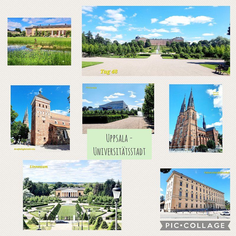
Uppsala
sightseeing. Well, you can leave it out. Unless you are interested in botany.
Schweden
59° 51' 30.8" N 17° 38' 20.1" E
59.8585638 17.6389267
• Head northeast on Drottninggatan.
• Turn right onto Östra Ågatan. Go for 230 m.
• Turn left onto Bangårdsgatan. Go for 311 m.
• Turn right onto Kungsgatan. Go for 1.6 km.
• Take the 2nd exit from roundabout onto Kungsgatan. Go for 310 m.
• Turn left onto Kungsängsleden. Go for 1.9 km.
• Take the 1st exit from Gnista Trafikplats roundabout onto E4.10 toward Stockholm/Arlanda Airport/77/Norrtälje. Go for 544 m.
• Take the 2nd exit from roundabout onto E4.10. Go for 1.0 km.
• Take the exit onto E4. Go for 56.3 km.
• Continue on E4 (Uppsalavägen) toward Stockholm/E20. Go for 15.7 km.
• Take exit 152 toward Sätra/Segeltorp onto Trafikplats Bredäng. Go for 386 m.
• Keep left onto Skärholmsvägen. Go for 958 m.
• Turn right onto Bredängs allé. Go for 52 m.
• Turn left onto Eksätravägen. Go for 188 m.
• Turn slightly right onto Björksätravägen. Go for 357 m.
• Turn right onto Ålgrytevägen. Go for 508 m.
• Turn left onto Stora Sällskapets väg. Go for 167 m.
• Arrive at Stora Sällskapets väg. Your destination is on the right.
☍
80,6 km
( 58 min.)
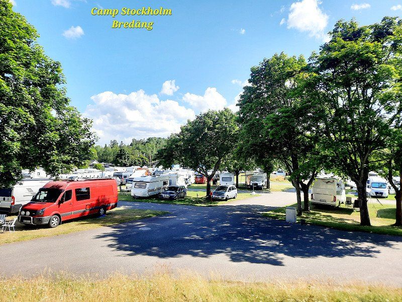
Bredäng Camping Stockholm
Very crowded, not cheap, but clean and well connected to the city by metro. Dogs stayed in the car again. Dogs are generally allowed on the metro without a muzzle, but only at certain entrances.
Stora Sällskapetsväg 60, 12731, Skärholmen, Schweden
59° 17' 43.8" N 17° 55' 23.8" E
59.2954900 17.9232900
• Head toward Ålgrytevägen on Stora Sällskapets väg. Go for 602 m.
• Turn left onto Bredängs allé. Go for 65 m.
• Continue on Bredängsvägen. Go for 1.7 km.
• Take ramp onto E4/E20 (Södertäljevägen) toward Sundsvall/Stockholm C. Go for 3.2 km.
• Take exit 154 toward Södermalm/Liljeholmen onto Södertäljevägen. Go for 3.1 km.
• Continue on Liljeholmsbron. Go for 358 m.
• Turn right onto Hornsgatan toward Skanstull/Medborgarplatsen/Södersjukhuset. Go for 2.3 km.
• Continue on Slussbron. Go for 209 m.
• Continue on Skeppsbron. Go for 754 m.
• Turn left onto Slottskajen. Go for 134 m.
• Turn right onto Gustav Adolfs torg. Go for 146 m.
• Continue on Gustav Adolfs torg. Go for 70 m.
• Turn left onto Gustav Adolfs torg. Go for 29 m.
• Arrive at Gustav Adolfs torg. Your destination is on the right.
☍
12,7 km
( 19 min.)
Stockholm
City tour without entrance fees and Museum Island.
Evenings are less crowded for photos and not as hot. Go straight to dinner. Thanks to Inga Lindström I expected more. Unfortunately was disappointed.
Schweden
59° 19' 45.6" N 18° 4' 6.9" E
59.3293235 18.0685808
• Head toward Arsenalsgatan on Gustav Adolfs torg. Go for 70 m.
• Turn left onto Regeringsgatan. Go for 64 m.
• Turn left onto Jakobsgatan. Go for 77 m.
• Turn right onto Malmtorgsgatan. Go for 149 m.
• Turn left onto Vattugatan. Go for 331 m.
• Keep left toward E4 S/E20 S/73/Södermalm. Go for 20 m.
• Keep left toward Centralbron/E4.25. Go for 21 m.
• Take ramp onto Centralbron (E4.25). Go for 1.1 km.
• Keep left onto E4.25 toward Nynäshamn/E4/Globen/E20/73. Go for 16.9 km.
• Take the exit toward Tyresö/Brandbergen. Go for 520 m.
• Take the 2nd exit from roundabout onto Gudöbroleden (260) toward Tyresö/Vendelsö/Brandbergen. Go for 324 m.
• Take the 1st exit from roundabout onto Gudöbroleden (260) toward 73/Stockholm/Tyresö/Vendelsö/Brandbergen. Go for 267 m.
• Take the 1st exit from roundabout onto Söderbyleden. Go for 322 m.
• Turn left onto Vendelsövägen. Go for 386 m.
• Turn right onto Vendelsömalmsvägen. Go for 335 m.
• Turn left onto Brandbergsleden. Go for 1.1 km.
• Turn right onto Tyrestavägen toward Tyresta. Go for 3.2 km.
• Continue on Tyrestavägen. Go for 237 m.
• Arrive at Tyrestavägen. Your destination is on the right.
☍
25,4 km
( 29 min.)
Day
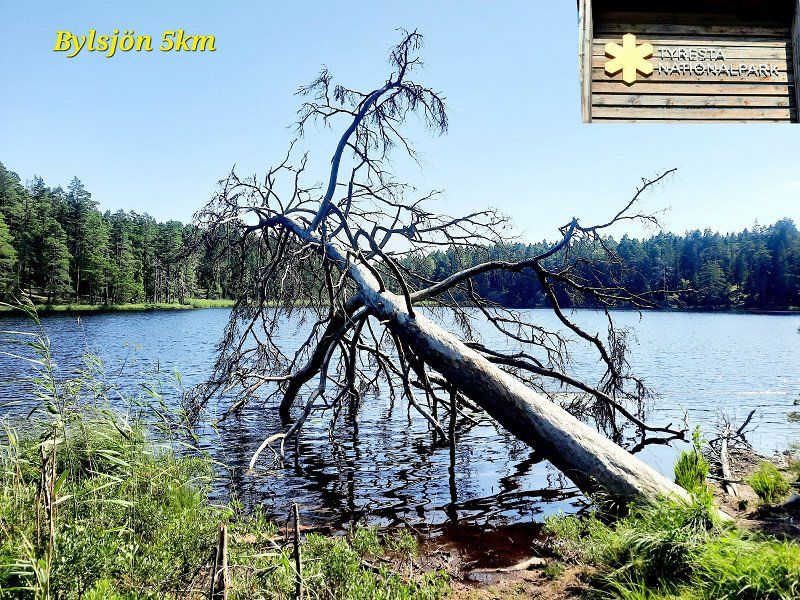
Tyresta
national park. Had no mosquitoes! Pram path 5km. But there are also longer hikes up to several days in the archipelago with tents and barbecue areas.
Schweden
59° 10' 4.9" N 18° 14' 14.5" E
59.1680160 18.2373533
• Head southeast on Tyrestavägen.
• Turn right onto Tyrestavägen. Go for 592 m.
• Turn left onto Tyrestavägen. Go for 2.7 km.
• Turn left onto Brandbergsleden. Go for 1.4 km.
• Turn right onto Söderbyleden. Go for 199 m.
• Take the 2nd exit from roundabout onto Söderbyleden. Go for 540 m.
• Take the 3rd exit from roundabout onto Gudöbroleden (260). Go for 245 m.
• Take ramp onto 73 toward Stockholm. Go for 13.5 km.
• Take ramp onto Skräddartunneln toward E4/E20/222. Go for 800 m.
• Take left ramp onto 75 (Södra länken) toward E4/E20. Go for 3.5 km.
• Take the left exit toward Helsingborg/Göteborg onto E4/E20 (Södertäljevägen). Go for 27.9 km.
• Take exit 143 toward Göteborg/Strängnäs/Södertälje C onto E20. Go for 10.8 km.
• Take exit 140 toward Järna/Nykvarn/Taxinge slott. Go for 396 m.
• Turn right onto 509 toward Strängnäs. Go for 106 m.
• Turn left onto Gamla Strängnäsvägen (576). Go for 7.2 km.
• Continue on Gamla Strängnäsvägen (576). Go for 3.9 km.
• Continue on 576. Go for 145 m.
• Turn left onto Spennarslingan. Go for 247 m.
• Turn left onto Spennarslingan. Go for 295 m.
• Arrive at Spennarslingan. Your destination is on the left.
☍
74,6 km
(1 hrs. 2 min.)
Nygårds hagar
Pitch alone, forest, rest, fireplace, walking paths
59.191104,17.339196
Schweden
59° 13' 3.5" N 17° 16' 55.7" E
59.2176294 17.2821301
• Head west on Spennarslingan. Go for 295 m.
• Turn right onto Spennarslingan. Go for 247 m.
• Turn left onto 576. Go for 67 m.
• Continue on Hällby (576). Go for 872 m.
• Continue on 576. Go for 1.1 km.
• Continue on Blåberga (990). Go for 70 m.
• Continue on 990. Go for 1.1 km.
• Continue on Kvartinge (990). Go for 449 m.
• Continue on Nystugan (990). Go for 281 m.
• Continue on Fredensborg (990). Go for 164 m.
• Continue on 990. Go for 320 m.
• Continue on Hedlandet Björkhem. Go for 2.5 km.
• Continue on Läggesta västra Brostugan (223). Go for 1.1 km.
• Turn right onto 223. Go for 1.1 km.
• Take the 2nd exit from roundabout onto 223. Go for 1.4 km.
• Continue on Ekarna (223). Go for 439 m.
• Continue on 223. Go for 127 m.
• Continue on Gripsholms Kungsladugård (223). Go for 161 m.
• Continue on 223. Go for 39 m.
• Continue on Stallarholmsvägen (223). Go for 258 m.
• Turn right onto Kärnbogatan. Go for 347 m.
• Continue on Ruddammsgatan. Go for 179 m.
• Arrive at Ruddammsgatan. Your destination is on the right.
☍
12,6 km
( 12 min.)
Day
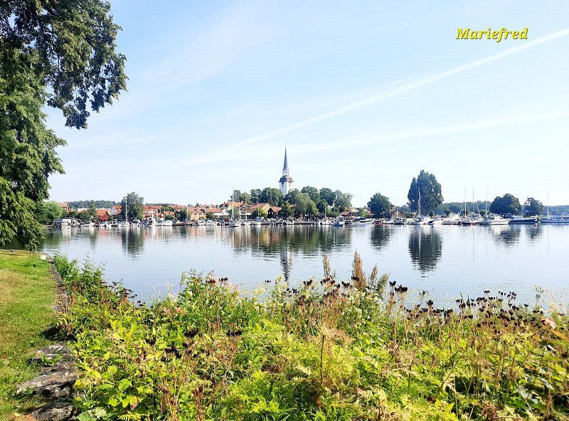
Mariefred
Castle, town and railroad
Schweden
59° 15' 43.3" N 17° 13' 23.2" E
59.2620381 17.2231100
• Head toward Rönnbärsvägen on Ruddammsgatan. Go for 179 m.
• Continue on Kärnbogatan. Go for 347 m.
• Turn left onto Stallarholmsvägen (223). Go for 258 m.
• Continue on 223. Go for 39 m.
• Continue on Gripsholms Kungsladugård (223). Go for 161 m.
• Continue on 223. Go for 127 m.
• Continue on Ekarna (223). Go for 439 m.
• Continue on 223. Go for 1.4 km.
• Take the 1st exit from roundabout onto 223. Go for 1.1 km.
• Turn left onto 223. Go for 1.1 km.
• Turn right onto 223. Go for 15.1 km.
• Turn right onto 223. Go for 8.5 km.
• Turn left onto 57/223 toward Södertälje/Gnesta. Go for 1.7 km.
• Arrive at 57/223. Your destination is on the left.
☍
30,5 km
( 29 min.)
Björnlunda
card holder
Schweden
59° 3' 57.9" N 17° 9' 42.1" E
59.0660880 17.1616906
• Head southeast on 57/223. Go for 303 m.
• Turn right onto 223 toward Björnlunda/Nyköping. Go for 31.2 km.
• Turn right onto 223. Go for 3.4 km.
• Turn right onto 223. Go for 3.5 km.
• Take the 1st exit from Ekensbergsrondellen roundabout onto Lennings väg (E4.9). Go for 726 m.
• Take the 1st exit from roundabout onto E4 toward Helsingborg/53. Go for 105 km.
• Take exit 111 toward Vimmerby/Motala/Linköping V onto 34 (Trafikplats Linköping västra). Go for 384 m.
• Keep right onto 34 toward Motala. Go for 18.8 km.
• Turn left toward Borensberg S. Go for 171 m.
• Continue on Brunneby Kårgården. Go for 472 m.
• Continue on Linköpingsvägen. Go for 2.2 km.
• Turn right toward Husbyvägen. Go for 6 m.
• Continue on Husbyvägen. Go for 31 m.
• Continue on Husbyvägen. Go for 288 m.
• Arrive at Husbyvägen.
☍
166,4 km
(1 hrs. 47 min.)
Borensberg
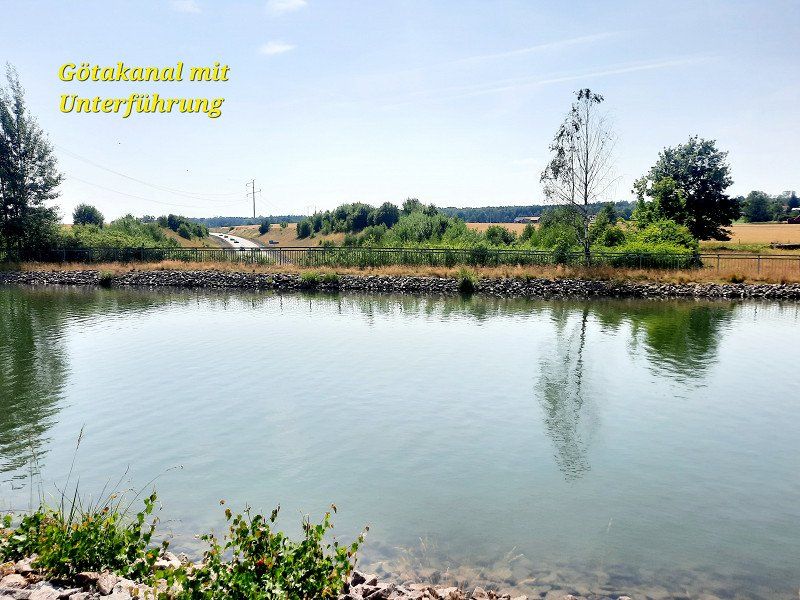
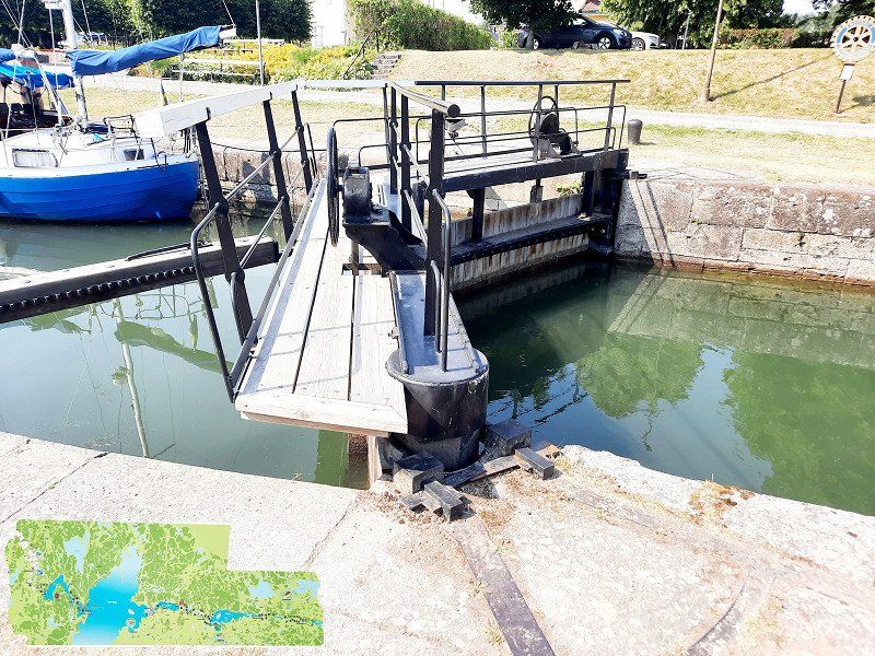
Visit the lock, but the one in Berg is higher
And the car underpass under the canal before entering the city. ingenious!
Schweden
58° 33' 44.4" N 15° 16' 54.4" E
58.5623445 15.2817690
• Head toward Vallgatan on Husbyvägen. Go for 642 m.
• Take the 2nd exit from roundabout onto Husbyvägen. Go for 1.2 km.
• Turn left onto 34. Go for 13.5 km.
• Turn right onto Metallvägen (34) toward 50/Sjukhus/Varamobaden/Bråstorp. Go for 845 m.
• Pass 3 roundabouts and continue on Metallvägen (34). Go for 2.1 km.
• Take the 3rd exit from roundabout onto Bergslagsdiagonalen (50) toward Jönköping. Go for 5.4 km.
• Take ramp toward Vadstena/Industriområde Norrsten/Södra Freberga. Go for 181 m.
• Take the 1st exit from roundabout onto Bergslagsdiagonalen toward Vadstena. Go for 1.2 km.
• Continue on Lillhamra. Go for 347 m.
• Continue on Bergslagsdiagonalen. Go for 26 m.
• Continue on Norrsten. Go for 293 m.
• Continue on Bergslagsdiagonalen. Go for 1.5 km.
• Continue on Skeppstad. Go for 222 m.
• Continue on Bergslagsdiagonalen. Go for 4.7 km.
• Pass 3 roundabouts and continue on Bergslagsdiagonalen. Go for 4.7 km.
• Take the 2nd exit from roundabout onto Bergslagsdiagonalen toward Ödeshög. Go for 10.4 km.
• Turn right onto Borghamnsvägen toward Borghamn. Go for 3.0 km.
• Arrive at Borghamnsvägen. Your destination is on the right.
☍
50,3 km
( 42 min.)
Borghamn
Barbecue and bathing area. Swimming and cooling off at 34 degrees is a must. Therefore we leave out Ekopark Omberg and the monastery ruins.
Schweden
58° 22' 56.8" N 14° 41' 38.5" E
58.3824313 14.6940258
• Head east on Borghamnsvägen. Go for 145 m.
• Turn right onto Skedagatan. Go for 474 m.
• Continue on Västerlösa. Go for 382 m.
• Continue on Rogslösa-Hässleby. Go for 272 m.
• Continue on Skedagatan. Go for 317 m.
• Continue on Skedagatan. Go for 861 m.
• Continue on Skedet Trädgårdshemmet. Go for 135 m.
• Continue on Skedet Fredensdal. Go for 118 m.
• Continue on Skedagatan. Go for 258 m.
• Continue on Nyby. Go for 177 m.
• Turn right onto Bergslagsdiagonalen. Go for 15.5 km.
• Turn right onto Fabriksvägen. Go for 1.2 km.
• Turn left onto Nygatan. Go for 493 m.
• Turn right onto Storgatan. Go for 252 m.
• Turn left onto Tranåsvägen. Go for 1.5 km.
• Continue on Tranåsvägen Svängen. Go for 1.1 km.
• Continue on Tranåsvägen Stridsborg. Go for 8.8 km.
• Continue on Boet Haglyckan. Go for 372 m.
• Continue on Boet Hagmansstugan. Go for 40 m.
• Continue on Boet Haga. Go for 332 m.
• Continue on Boet Hagen. Go for 1.6 km.
• Continue on Boet Uppsala gård. Go for 75 m.
• Continue on Boet Blixhult. Go for 6.7 km.
• Continue on Hålan Solbacka. Go for 2.5 km.
• Continue on Svärdsfalla. Go for 933 m.
• Continue on Rödje Bygget. Go for 894 m.
• Continue on Rödje Björkvik. Go for 877 m.
• Continue on Kungshult Bäckstugan. Go for 550 m.
• Continue on Kungshult Kristinedal. Go for 531 m.
• Continue on Kungshult Sågstugan. Go for 121 m.
• Continue on Björkenäs. Go for 54 m.
• Continue on Björkenäs Turelund. Go for 512 m.
• Continue on Åviken. Go for 1.1 km.
• Continue on Hårkrankeryds skola. Go for 505 m.
• Continue on Hårkrankeryd Västeräng. Go for 2.0 km.
• Turn left and take ramp onto 32 toward Eksjö. Go for 48.1 km.
• Take ramp onto Broarpsvägen (40) toward Västervik. Go for 670 m.
• Take the 2nd exit from roundabout onto Broarpsvägen (40) toward Västervik. Go for 812 m.
• Take the 2nd exit from roundabout onto Västerlånggatan toward Sjukhus C-Ring. Go for 139 m.
• Take the 1st exit from roundabout onto Köpmangatan. Go for 43 m.
• Turn left onto Köpmangatan. Go for 128 m.
• Arrive at Köpmangatan. Your destination is on the left.
☍
101,4 km
(1 hrs. 24 min.)
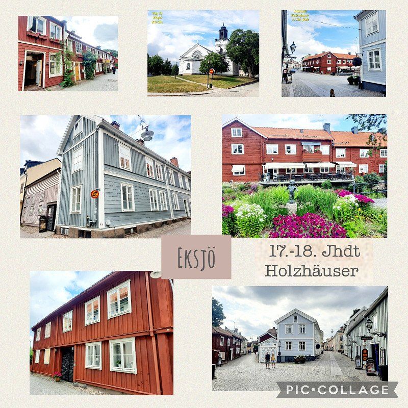
Eksjö
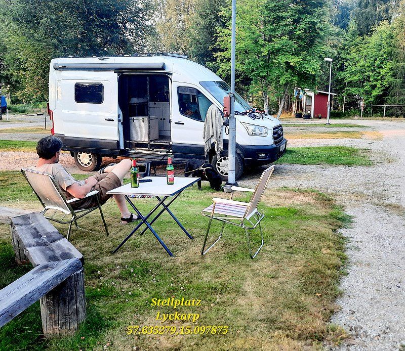
Pitch Lyckarp
57.635279,15.097875
Great pitch 10€ without electricity
Schweden
57° 39' 54.6" N 14° 58' 23.6" E
57.6651652 14.9732214
• Head east on Köpmangatan.
• Arrive at Köpmangatan. Your destination is on the left.
☍
Distance not available
(Duration not available)
Day
Eksjö
Visit to the wooden houses from the 17th-19th centuries. century
Schweden
57° 39' 54.6" N 14° 58' 23.6" E
57.6651652 14.9732214
• Head toward Södra Storgatan on Köpmangatan. Go for 157 m.
• Take the 3rd exit from roundabout onto Västerlånggatan. Go for 156 m.
• Take the 1st exit from roundabout onto Broarpsvägen (40) toward Jönköping/32/128/134. Go for 800 m.
• Take the 2nd exit from roundabout onto Broarpsvägen (40) toward Jönköping/32/128/134. Go for 284 m.
• Take ramp onto 32/40 toward Vetlanda/Jönköping/128/Abborravik. Go for 1.2 km.
• Take the 3rd exit from roundabout onto 32 toward Vetlanda/Nifsarp. Go for 15.8 km.
• Turn left onto 31/32/47 toward Oskarshamn/Vetlanda. Go for 9.5 km.
• Take the 2nd exit from Nydala Rondellen roundabout onto Västerleden (31/47) toward Kalmar/Oskarshamn/Värnamo. Go for 1.9 km.
• Take the 2nd exit from Cirkulationsplats Vetlanda västra roundabout onto Västerleden (31/47) toward Kalmar/Oskarshamn/28/125. Go for 3.6 km.
• Take the 1st exit from Hargenrondellen roundabout onto 31 toward Karlskrona/Kalmar. Go for 60.5 km.
• Turn right onto 28. Go for 8.7 km.
• Turn left onto Rydvägen. Go for 393 m.
• Turn right onto Stora vägen. Go for 170 m.
• Arrive at Stora vägen.
☍
103,1 km
(1 hrs. 20 min.)
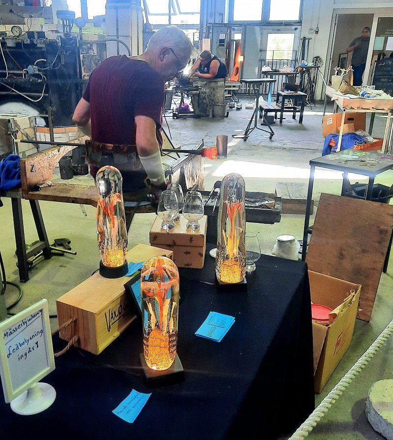
Kosta
Visit to the glass blowing workshop. It's good that the tours were fully booked and we went to the next one.
Such a mainstream. Excalibur City is nothing like that.
Schweden
56° 50' 38.6" N 15° 23' 45.7" E
56.8440678 15.3960304
• Head south on Stora vägen.
• Turn right onto Parkvägen. Go for 292 m.
• Turn right toward Rydvägen. Go for 179 m.
• Turn left onto Rydvägen. Go for 105 m.
• Turn right onto 28. Go for 8.7 km.
• Turn right onto 31. Go for 12.7 km.
• Turn left onto Södra Måleråsvägen toward Alstermo/Målerås. Go for 1.1 km.
• Continue on Lindvägen. Go for 220 m.
• Turn right onto Meléns väg. Go for 39 m.
• Arrive at Meléns väg. Your destination is on the right.
☍
23,4 km
( 17 min.)
Målerås
Visit to the glass factory. Quiet, individual, lots of handcraft, great history, friendly staff, presentation in English but free of charge. Glass blowing is in. If you want to design something yourself 400 SEK.
Very creative pieces from the old master and owner of the factory.
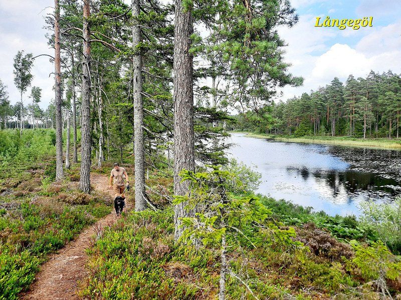
Hike at Långegol Badeplats 2km or just go swimming (no dogs).
Schweden
56° 54' 53.1" N 15° 34' 9.4" E
56.9147405 15.5692751
• Head toward Nygatan on Meléns väg. Go for 58 m.
• Turn left onto Nygatan. Go for 24 m.
• Turn left onto Norra Måleråsvägen. Go for 96 m.
• Continue on Lindvägen. Go for 243 m.
• Continue on Södra Måleråsvägen. Go for 1.1 km.
• Turn left onto Långaskruv (31). Go for 28.1 km.
• Turn left onto Norra vägen (31) toward 25/Kalmar. Go for 4.1 km.
• Take the 3rd exit from roundabout onto Kalmarvägen (25) toward Kalmar. Go for 22.6 km.
• Take ramp onto E22. Go for 5.1 km.
• Take the exit toward Öland onto 137 (Ölandsleden). Go for 11.9 km.
• Take ramp onto 136 toward Ottenby/Mörbylånga. Go for 37.1 km.
• Turn left onto Torngårdsvägen. Go for 5.1 km.
• Continue on Solberga. Go for 2.1 km.
• Turn right onto Torngård. Go for 514 m.
• Continue on Gammalsby. Go for 776 m.
• Continue on Gammalsby. Go for 241 m.
• Continue on Mellstaby. Go for 1.1 km.
• Arrive at Gräsgård. Your destination is on the right.
☍
120,2 km
(1 hrs. 38 min.)
Gräsgård
Oland.
Parking space at the port 12 € without electricity with toilet, shower, washing-up area
Schweden
56° 18' 35.2" N 16° 30' 32.6" E
56.3097914 16.5090460
• Head northeast on Gräsgård. Go for 1.1 km.
• Continue on Gammalsby. Go for 356 m.
• Continue on Gammalsby. Go for 661 m.
• Continue on Torngård. Go for 514 m.
• Turn left toward Solberga. Go for 51 m.
• Continue on Solberga. Go for 2.1 km.
• Continue on Pilekulla. Go for 5.1 km.
• Turn right onto Södra Möcklebyvägen (136). Go for 36.5 km.
• Continue on Björnhovda. Go for 337 m.
• Take ramp toward Byxelkrok/Borgholm. Go for 278 m.
• Turn right onto 136. Go for 23.9 km.
• Turn left onto Sollidenvägen. Go for 693 m.
• Turn right. Go for 11 m.
• Arrive at your destination.
☍
71,5 km
(1 hrs. 6 min.)
Day
Borgholms Slott, Sollidenvägen, Borgholm, Schweden
Worth seeing even if it doesn't look like it from the outside. 100 SEK entrance fee per person. Lots to discover. Beautiful exhibition about the history of the castle and for children there is a separate medieval adventure world.
Dogs allowed.
Sollidenvägen 5, 387 94 Borgholm, Schweden
56° 52' 13.9" N 16° 38' 36.5" E
56.8705404 16.6434598
• Head toward Sollidenvägen. Go for 11 m.
• Continue on Sollidenvägen. Go for 831 m.
• Arrive at Sollidenvägen. Your destination is on the right.
☍
0,8 km
( 2 min.)
Sollidens Slott, Borgholm, Schweden
Not visited as 170 SEK entry. Very nice park and the summer palace of the royal. Family. Dogs are allowed in. You have to go through a metal detector including a dog. ;-)
387 92 Borgholm, Schweden
56° 52' 1.2" N 16° 38' 12.6" E
56.8669918 16.6368413
• Head east on Sollidenvägen. Go for 831 m.
• Turn right onto Sollidenvägen. Go for 693 m.
• Turn right onto 136. Go for 23.9 km.
• Continue on 137. Go for 10.5 km.
• Take ramp onto Tallhagsvägen toward Centrum. Go for 383 m.
• Continue on Ängöleden. Go for 2.0 km.
• Take the 1st exit from roundabout onto Ängöleden. Go for 142 m.
• Turn right toward Södra Kanalgatan. Go for 56 m.
• Continue on Södra Kanalgatan. Go for 309 m.
• Take the 2nd exit from roundabout onto Södra Kanalgatan. Go for 241 m.
• Turn right onto Malmbron. Go for 47 m.
• Take the 2nd exit from roundabout onto Esplanaden. Go for 277 m.
• Turn left onto Norra vägen. Go for 118 m.
• Continue on Tullslätten. Go for 152 m.
• Take the 2nd exit from roundabout onto Slottsvägen. Go for 511 m.
• Turn left onto Kungsgatan. Go for 52 m.
• Arrive at Kungsgatan.
☍
40,2 km
( 38 min.)
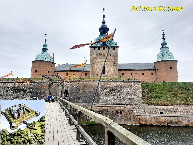
Kalmar Slott, Kungsgatan 1, Kalmar, Schweden
Just looked around and from the outside. Entry ?
The cathedral is still within walking distance to visit. It's busy and parking is scarce nearby. You can also go to the beach right next to it.
Kungsgatan 1, 392 33 Kalmar, Schweden
56° 39' 29" N 16° 21' 18.9" E
56.6580672 16.3552365
• Head toward Slottsvägen on Kungsgatan. Go for 562 m.
• Turn right onto Stensövägen. Go for 219 m.
• Turn left onto Södra vägen. Go for 473 m.
• Pass 2 roundabouts and continue on Södra vägen. Go for 1.7 km.
• Continue on Svanebergs gård. Go for 732 m.
• Take the 3rd exit from roundabout onto Södra vägen. Go for 166 m.
• Turn right and take ramp onto E22 toward Malmö/Halmstad/25. Go for 69.7 km.
• Take ramp. Go for 273 m.
• Turn left toward Häjetorpsvägen. Go for 199 m.
• Turn right onto Häjetorpsvägen toward Ramdala. Go for 850 m.
• Continue on Häjetorp. Go for 709 m.
• Continue on Säby. Go for 1.4 km.
• Turn left onto Möcklövägen. Go for 2.0 km.
• Continue on Möcklö Karlsberg. Go for 752 m.
• Continue on Möcklövägen. Go for 540 m.
• Continue on Möcklösundsbron. Go for 586 m.
• Continue on Senorenvägen. Go for 802 m.
• Continue on Östernäs. Go for 702 m.
• Continue on Senorenvägen. Go for 394 m.
• Continue on Skällösundsbron. Go for 192 m.
• Continue on Sturkövägen. Go for 5.6 km.
• Turn left onto Ekenabbsvägen. Go for 1.2 km.
• Turn right onto Djupasundsleden. Go for 663 m.
• Continue on Djupasundsleden. Go for 1.4 km.
• Turn right onto Norra Tjurkövägen. Go for 139 m.
• Turn right onto Lejonvägen. Go for 870 m.
• Turn right onto Sundets väg. Go for 125 m.
• Arrive at Sundets väg.
☍
92,9 km
(1 hrs. 14 min.)
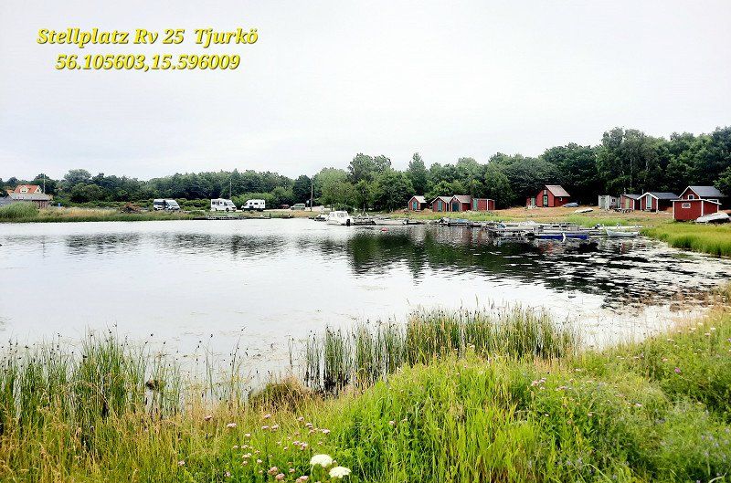
Tjurkö, Schweden
Follow RV 25 between the islands to the end of the road. Parking space in a quiet little fishing port in front of the military island in front of Karlskron.
56.105785, 15.595410
56° 6' 42.3" N 15° 37' 34.8" E
56.1117615 15.6263332
• Head north on Sundets väg. Go for 125 m.
• Turn left onto Lejonvägen. Go for 870 m.
• Turn left onto Norra Tjurkövägen. Go for 139 m.
• Turn left onto Djupasundsleden. Go for 1.4 km.
• Continue on Tjurköbron. Go for 663 m.
• Turn left onto Ekenabbsvägen. Go for 1.2 km.
• Turn right onto Sturkövägen. Go for 5.6 km.
• Continue on Skällösundsbron. Go for 192 m.
• Continue on Senorenvägen. Go for 394 m.
• Continue on Östernäs. Go for 702 m.
• Continue on Senorenvägen. Go for 869 m.
• Continue on Möcklösundsbron. Go for 566 m.
• Continue on Möcklövägen. Go for 493 m.
• Continue on Möcklö Karlsberg. Go for 752 m.
• Continue on Möcklövägen. Go for 2.0 km.
• Continue on Sjöbrisvägen. Go for 93 m.
• Continue on Gängletorpsvägen. Go for 174 m.
• Continue on Gängletorp. Go for 996 m.
• Take the 2nd exit from roundabout onto Antons väg. Go for 602 m.
• Continue on Gängletorpsvägen. Go for 1.8 km.
• Take the 2nd exit from roundabout. Go for 110 m.
• Take the 2nd exit from roundabout onto E22. Go for 5.7 km.
• Take ramp onto Österleden (28/122) toward Karlskrona Ö C/Vetlanda/Växjö. Go for 684 m.
• Take the 2nd exit from roundabout onto Österleden (28) toward Gdynia/Centrum. Go for 941 m.
• Continue on Österleden (28) toward Marieberg/Kungsmarken/Gullberna. Go for 4.4 km.
• Turn left onto Skeppsbrokajen. Go for 360 m.
• Turn right onto Drottninggatan. Go for 622 m.
• Turn right onto Kyrkogatan. Go for 164 m.
• Turn right onto Stortorget. Go for 44 m.
• Turn left onto Fredrikskyrkan. Go for 112 m.
• Arrive at Fredrikskyrkan. Your destination is on the left.
☍
32,8 km
( 35 min.)
Day
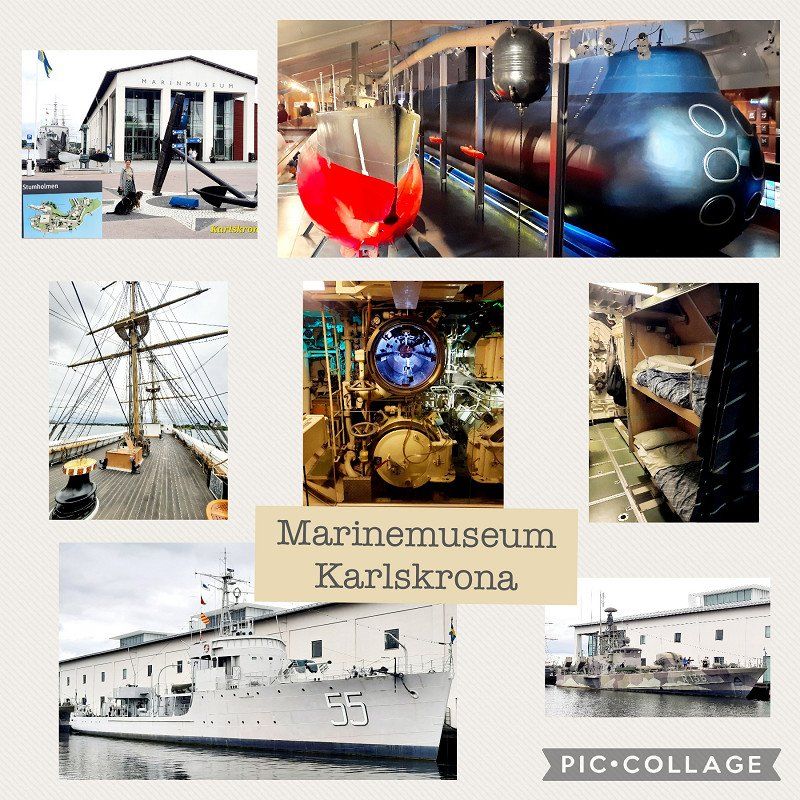
Karlskrona, Schweden
downtown visited. Oh well.
The Naval Museum is interesting and above all free.
Many ships, submarines, historical, also interactive. much also explained for children.
Dogs are allowed on the premises, but not in the exhibition rooms.
There is a lido with a diving tower, free of charge on the premises.
Marine parking, costs, right next to it.
56° 9' 40.4" N 15° 35' 12.8" E
56.1612240 15.5869000
• Head toward Norra Smedjegatan on Fredrikskyrkan. Go for 112 m.
• Turn right onto Stortorget. Go for 44 m.
• Turn left onto Kyrkogatan. Go for 164 m.
• Turn left onto Drottninggatan. Go for 622 m.
• Turn left onto Skeppsbrokajen. Go for 310 m.
• Turn right onto Österleden (28). Go for 2.6 km.
• Take ramp onto Sunnavägen (E22) toward Ronneby. Go for 1.4 km.
• Take the 2nd exit from roundabout onto Ronnebyvägen (E22). Go for 2.2 km.
• Take ramp onto E22. Go for 8.2 km.
• Pass 2 roundabouts and continue on E22. Go for 85.2 km.
• Turn left onto Nymövägen. Go for 2.6 km.
• Turn right onto Möllehusvägen. Go for 2.7 km.
• Turn left onto Hallingavägen. Go for 3.6 km.
• Turn left onto Åhusvägen (118) toward Åhus. Go for 6.5 km.
• Take the 2nd exit from roundabout onto Yngsjövägen (118) toward Ystad/Simrishamn. Go for 761 m.
• Take the 2nd exit from roundabout onto Yngsjövägen (118). Go for 16.9 km.
• Turn left onto 9/19 toward Ystad/Simrishamn/Tomelilla. Go for 10.1 km.
• Turn left onto Albovägen (9) toward Simrishamn/Kivik/Brösarp. Go for 394 m.
• Turn right onto Brunnsviksvägen. Go for 28 m.
• Arrive at Brunnsviksvägen. Your destination is on the left.
☍
144,6 km
(1 hrs. 46 min.)
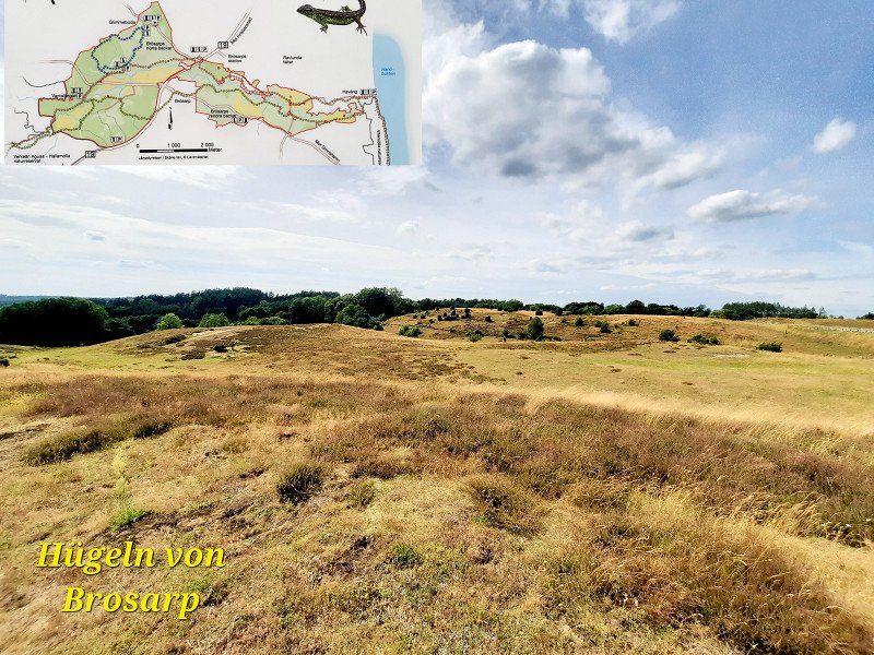
Brösarp
Hill walk 6km from Glimmebodagården through forest, over sandy hills, paddocks.
Take plenty of water with you, even if in the shade in the forest. Only 2x streams for the dogs. A few meters are also for walking.
Very beautiful and varied.
Schweden
55° 43' 31" N 14° 6' 3.4" E
55.7252700 14.1009400
• Head west on Brunnsviksvägen. Go for 32 m.
• Turn right onto Brunnsviksvägen. Go for 48 m.
• Turn right onto Albovägen (9). Go for 16.7 km.
• Turn left onto Rörumsstrandsvägen. Go for 971 m.
• Turn slightly right onto Rörumsstrandsvägen. Go for 1.1 km.
• Turn right onto Knäbäckshusen. Go for 143 m.
• Arrive at Knäbäckshusen.
☍
19,1 km
( 20 min.)
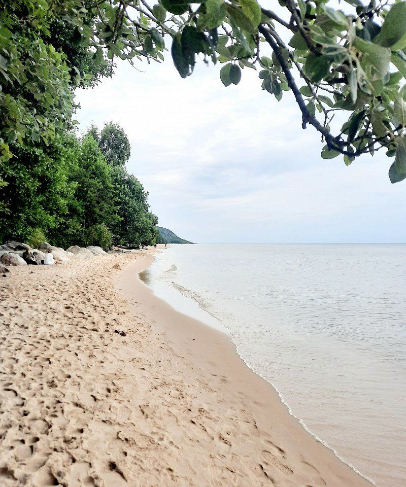
Knäbäckshusen
beautiful beach Apart from the cold water, visually like Thailand. Unfortunately dogs are not allowed.
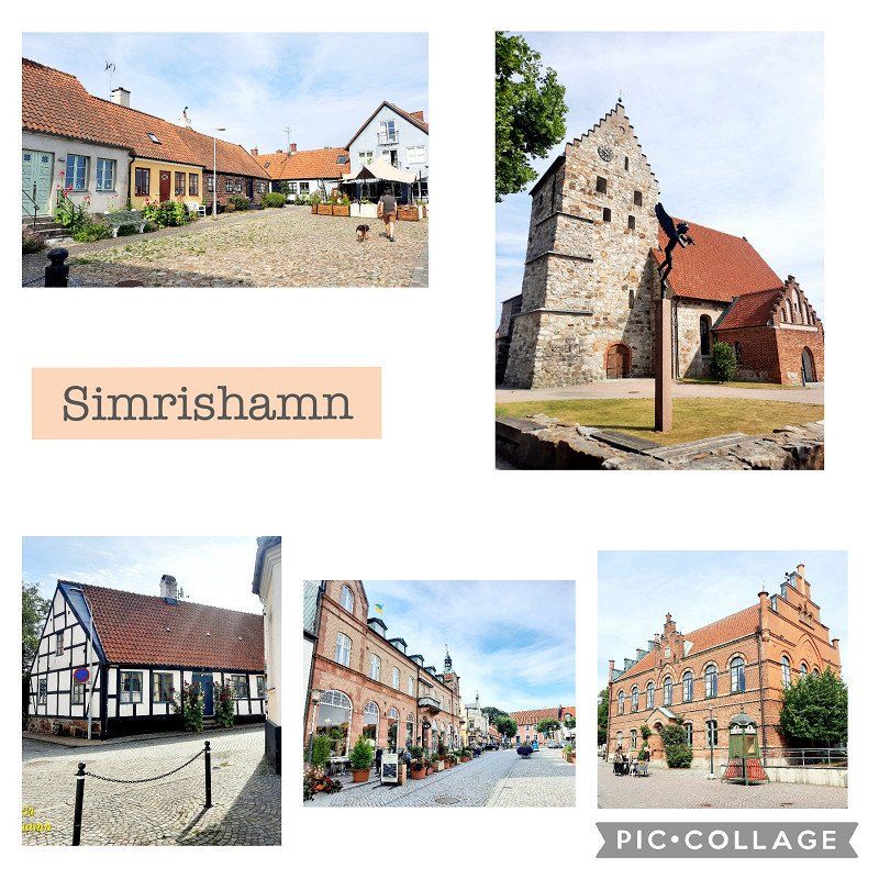
Simrishamn, Schweden
55° 38' 28" N 14° 16' 25.1" E
55.6411202 14.2736445
• Head toward Rörumsstrandsvägen on Knäbäckshusen. Go for 143 m.
• Turn left onto Rörumsstrandsvägen. Go for 2.1 km.
• Turn left onto Rörums stora väg (9). Go for 4.4 km.
• Turn left onto Tjörnedala toward Gladsax/Baskemölla. Go for 242 m.
• Continue on Tjörnedalavägen. Go for 1.3 km.
• Turn left onto Lindqvists backe. Go for 97 m.
• Arrive at Lindqvists backe. Your destination is on the left.
☍
8,4 km
( 11 min.)
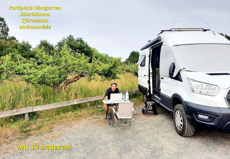
Baskemölla
parking space
Tjörnedala strövområde
13 others at the trail parking lot next to the orchard. But calm and beautiful.
Schweden
55° 35' 33.3" N 14° 18' 51.8" E
55.5925873 14.3143772
• Head toward Gamla Baskevägen on Lindqvists backe. Go for 60 m.
• Turn right onto Gamla Baskevägen. Go for 48 m.
• Turn right onto Denkers backe. Go for 165 m.
• Turn left onto Frans Löfströms väg. Go for 566 m.
• Turn left onto 9. Go for 4.0 km.
• Continue on Kristianstadsvägen toward Centrum. Go for 109 m.
• Turn left onto Storgatan. Go for 107 m.
• Turn left onto Stora Rådmansgatan. Go for 128 m.
• Arrive at Stora Rådmansgatan. Your destination is on the right.
☍
5,2 km
( 7 min.)
Day
Simrishamn
sightseeing
Schweden
55° 33' 26.6" N 14° 20' 56.3" E
55.5573959 14.3489651
• Head toward Klockaresträdet on Stora Rådmansgatan. Go for 22 m.
• Turn left onto Lilla Norregatan. Go for 77 m.
• Turn left onto Yngve Östbergs väg. Go for 161 m.
• Continue on Yngve Östbergs väg (9). Go for 351 m.
• Turn right onto Storgatan (9) toward Ystad/Malmö/11. Go for 300 m.
• Pass 2 roundabouts and continue on Christian IV:s väg (9). Go for 1.4 km.
• Take the 2nd exit from roundabout toward Skillinge. Go for 123 m.
• Continue on Höga vägen. Go for 8.3 km.
• Turn left onto Gislövsdalsvägen. Go for 340 m.
• Continue on Kaptensgatan. Go for 604 m.
• Take the 3rd exit from roundabout onto Hamngatan. Go for 193 m.
• Continue on Strandgatan. Go for 729 m.
• Continue on Örnahusvägen. Go for 7.5 km.
• Continue on Sandby. Go for 2.9 km.
• Continue on Gamla Järavägen. Go for 234 m.
• Continue on Östra Kustvägen. Go for 189 m.
• Continue on Ingridvägen. Go for 608 m.
• Continue on Östra Kustvägen. Go for 6.2 km.
• Continue on Egebjersvägen. Go for 567 m.
• Turn left onto Ales väg. Go for 384 m.
• Arrive at Ales väg.
☍
31,2 km
( 32 min.)
Kåseberga
Ales stenar
The most unnecessary stones you can see on a cow pasture full of shit.
Crowds of people make a pilgrimage.
Dogs allowed. No entry. Only parking costs.
Schweden
55° 23' 11.6" N 14° 3' 54.4" E
55.3865519 14.0651143
• Head toward Hommevägen on Ales väg. Go for 384 m.
• Turn left onto Östra Kustvägen. Go for 7.8 km.
• Turn left onto 9. Go for 8.5 km.
• Take the 2nd exit from roundabout onto Österleden toward E65/Centrum. Go for 901 m.
• Turn right onto Jennygatan. Go for 358 m.
• Turn left onto Österportstorg. Go for 68 m.
• Continue on Blekegatan. Go for 510 m.
• Continue on Bryggaregatan. Go for 103 m.
• Take the 3rd exit from roundabout onto Kristianstadsvägen. Go for 163 m.
• Turn left onto Stora Norregatan. Go for 313 m.
• Turn left onto Stortorget. Go for 87 m.
• Arrive at Stortorget. Your destination is on the right.
☍
19,1 km
( 21 min.)
Ystad
Nice half-timbered buildings. Maybe nice if you know the Wallander crime novels. Lots of eating out and shopping in the city.
Schweden
55° 25' 46.2" N 13° 49' 12.1" E
55.4295051 13.8200308
• Head east on Stortorget. Go for 25 m.
• Turn left onto Garvaregränd. Go for 41 m.
• Turn slightly left onto Klostergatan. Go for 310 m.
• Take the 4th exit from roundabout onto Kristianstadsvägen. Go for 173 m.
• Turn right onto Bellevuevägen. Go for 340 m.
• Take the 2nd exit from roundabout onto Bellevuevägen. Go for 1.0 km.
• Take the 3rd exit from roundabout onto Ringleden (E65) toward Malmö/Trelleborg. Go for 1.1 km.
• Pass 3 roundabouts and continue on E65. Go for 48.0 km.
• Take exit 14 toward Trelleborg onto E6/E20/E22 (Yttre Ringvägen). Go for 5.7 km.
• Take exit 12 toward Trelleborg onto E6/E22 (Trelleborgsvägen). Go for 10.8 km.
• Take exit 8 toward Skanör/Falsterbo/Höllviken onto 100. Go for 5.4 km.
• Take the 2nd exit from roundabout onto 100. Go for 7.1 km.
• Take the 3rd exit from roundabout. Go for 117 m.
• Continue on Strandbadsvägen. Go for 1.6 km.
• Turn right onto Kullsbackavägen. Go for 639 m.
• Turn left onto Vallbovägen. Go for 40 m.
• Turn right onto Kullagränd. Go for 158 m.
• Arrive at Kullagränd. Your destination is on the left.
☍
82,5 km
(1 hrs. )
Falsterbo
Lighthouse. Southernmost point of Sweden. Not to compare with Lindesnes Norway.
Those were the most unnecessary kilometers driven. Looks nothing alike, no parking and is on a golf course. The balls fly low and hard. Enter at your own risk! If you take the walk out onto the peninsula you might see seals. It was too hot for us that day.
Schweden
55° 23' 49.6" N 12° 50' 29.5" E
55.3971210 12.8415278
• Head toward Vallgränd on Kullagränd. Go for 158 m.
• Turn left onto Vallbovägen. Go for 40 m.
• Turn right onto Kullsbackavägen. Go for 639 m.
• Turn left onto Strandbadsvägen. Go for 1.6 km.
• Turn right onto Malmövägen (100). Go for 7.1 km.
• Take the 2nd exit from roundabout onto 100. Go for 4.7 km.
• Take ramp onto E6/E22. Go for 10.0 km.
• Continue on E6.1 (Trelleborgsvägen) toward Malmö/Sjukhus. Go for 2.0 km.
• Continue on Trelleborgsvägen toward Centrum/Sjukhus. Go for 2.7 km.
• Turn left onto Dalaplan toward Centrum/Sjukhus. Go for 119 m.
• Turn right onto Södra Förstadsgatan toward Sjukhus. Go for 655 m.
• Continue on Bergsgatan. Go for 901 m.
• Turn slightly left onto Amiralsgatan. Go for 603 m.
• Continue on Studentgatan. Go for 96 m.
• Continue on Djäknegatan. Go for 103 m.
• Turn left onto Baltzarsgatan. Go for 47 m.
• Arrive at Baltzarsgatan. Your destination is on the right.
☍
31,5 km
( 30 min.)
Malmö
Just a waypoint for us. We've been there before. Nothing worth seeing unless you want to go shopping.
Schweden
55° 36' 17.9" N 13° 0' 13.8" E
55.6049810 13.0038220