Round trip to the State Garden Show BW 2024 and through the Black Forest
Day
Zürich
Uraniastrasse 3, Zürich, Bezirk Zürich, Zürich, Schweiz
47° 22' 26.6" N 8° 32' 27.9" E
47.3740506 8.5410752
• Head toward Schipfe on Uraniastrasse. Go for 32 m.
• Continue on Oetenbachgasse. Go for 25 m.
• Turn right onto Lindenhofstrasse. Go for 130 m.
• Turn left onto Lindenhofstrasse. Go for 53 m.
• Turn right onto Werdmühlestrasse. Go for 55 m.
• Continue on Beatenplatz. Go for 18 m.
• Continue on Waisenhausstrasse. Go for 74 m.
• Continue on Bahnhofplatz. Go for 31 m.
• Turn right onto Bahnhofplatz. Go for 89 m.
• Turn left onto Bahnhofquai. Go for 159 m.
• Keep right onto Walchebrücke. Go for 87 m.
• Continue on Walcheplatz. Go for 47 m.
• Continue on Walchestrasse. Go for 167 m.
• Continue on Stampfenbachstrasse. Go for 187 m.
• Turn left onto Wasserwerkstrasse. Go for 452 m.
• Keep right onto Milchbucktunnel (A1L) toward Winterthur/Schaffhausen/Flughafen. Go for 5.1 km.
• Continue on A1/A4. Go for 19.9 km.
• Continue on A1 toward St. Gallen/Kreuzlingen/Winterthur-Ohringen. Go for 82.9 km.
• Continue on A13. Go for 2.1 km.
• Take exit 2 toward Berneck/Lustenau. Go for 352 m.
• Take the 3rd exit from roundabout onto Zollstrasse (435) toward München/Lustenau. Go for 358 m.
• Continue on Lustenauer Straße (L204). Go for 383 m.
• Turn left onto Reichsstraße (L203) toward Bregenz/Höchst Hard/Industrie Nord. Go for 841 m.
• Turn left onto Maria-Theresien-Straße (L203). Go for 1.1 km.
• Turn right onto Zellgasse (L41). Go for 2.9 km.
• Continue on Senderstraße (L41). Go for 2.3 km.
• Turn left and take ramp onto A14 (Rheintal Autobahn) toward Deutschland/Bregenz. Go for 12.8 km.
• Continue on A96. Go for 5.1 km.
• Take exit 4 toward Weißensberg/Kempten/Isny/Hergensweiler. Go for 320 m.
• Turn right onto B12 toward Kempten/Isny/Hergatz/Hergensweiler. Go for 3.9 km.
• Take the 2nd exit from roundabout onto Kemptener Straße (B12) toward Kempten/Isny. Go for 9.8 km.
• Take the 2nd exit from roundabout onto Südring. Go for 258 m.
• Turn right onto Professor-Bolter-Straße. Go for 64 m.
• Turn left onto Schultheiß-Trenkle-Straße. Go for 153 m.
• Arrive at Schultheiß-Trenkle-Straße. Your destination is on the left.
☍
152,1 km
(1 hrs. 50 min.)
Wohnmobilstellplatz Wangen im Allgäu
Südring, 88239, Wangen im Allgäu, Germany
47° 40' 47" N 9° 50' 2.8" E
47.6797216 9.8341159
• Head toward Professor-Bolter-Straße on Schultheiß-Trenkle-Straße. Go for 169 m.
• Turn right onto Professor-Bolter-Straße. Go for 122 m.
• Turn left onto Südring. Go for 215 m.
• Take the 2nd exit from roundabout onto Erzbergerstraße (B32). Go for 322 m.
• Take the 2nd exit from roundabout onto Friedrich-Ebert-Straße (B32) toward München/Memmingen/Ravensburg. Go for 665 m.
• Turn right onto Leutkircher Straße (L320) toward Memmingen/Leutkirch. Go for 1.0 km.
• Take the 2nd exit from roundabout onto Leutkircher Straße (L320). Go for 4.0 km.
• Turn right and take ramp onto A96 toward Memmingen/München. Go for 38.2 km.
• Take exit 12 toward Füssen/Memmingen-Süd onto A7. Go for 4.7 km.
• Take exit 129 toward Ottobeuren. Go for 254 m.
• Continue on St2031 toward Ottobeuren. Go for 1.1 km.
• Turn right onto Oberbrühlstraße. Go for 801 m.
• Turn right onto Riedbachstraße. Go for 186 m.
• Continue on Schaltwerkstraße. Go for 692 m.
• Continue on Industriestraße (MN18). Go for 719 m.
• Continue on MN18. Go for 1.5 km.
• Continue toward St2013. Go for 539 m.
• Turn right onto St2013. Go for 2.1 km.
• Take the 2nd exit from roundabout onto St2013. Go for 2.8 km.
• Turn left onto Hawanger Straße. Go for 183 m.
• Turn right toward Hawanger Straße. Go for 160 m.
• Continue on Hawanger Straße. Go for 176 m.
• Arrive at your destination on the right.
☍
60,7 km
( 41 min.)
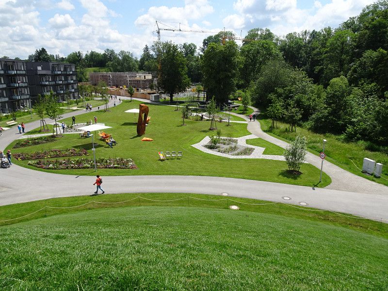
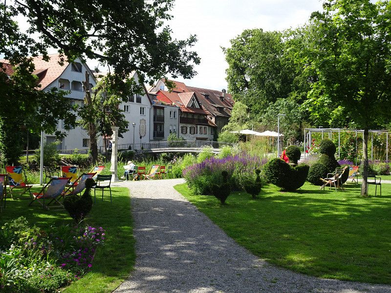
Landesgartenschau BW
We visited the State Garden Show shortly after it was affected by flooding caused by heavy rain. However, when we visited, there was almost nothing left to see.
The facilities are very spacious and in many places very close to nature.
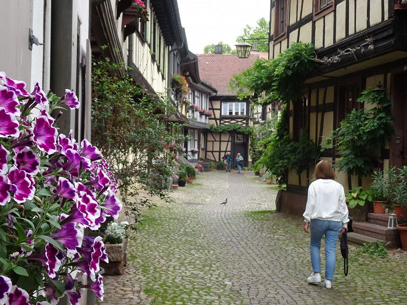
We also didn’t miss a visit to the historic old town centre.
Day
Camping Ottobeuren GmbH
Hawanger Straße 20, 87724, Ottobeuren, Germany
47° 57' 4.3" N 10° 17' 13.6" E
47.9512000 10.2871000
• Head northeast. Go for 16 m.
• Turn right. Go for 89 m.
• Turn left toward Hawanger Straße. Go for 21 m.
• Continue on Hawanger Straße. Go for 284 m.
• Turn left onto Hawanger Straße. Go for 183 m.
• Turn right onto St2013. Go for 2.7 km.
• Pass 2 roundabouts and continue on St2013. Go for 5.1 km.
• Turn right onto Tiroler Ring (St2009). Go for 1.6 km.
• Take the 1st exit from roundabout onto Münchner Straße (St2009). Go for 469 m.
• Take the 2nd exit from roundabout onto St2009 toward Lindau/München/Trunkelsberg. Go for 192 m.
• Turn left and take ramp onto A96 toward Lindau. Go for 3.7 km.
• Take exit 13 toward Würzburg/Ulm/Stuttgart onto A7. Go for 53.8 km.
• Take exit 120 toward Stuttgart/Ulm onto A8. Go for 101 km.
• Continue on A8 toward Karlsruhe/Basel/Leonberg-West. Go for 27.0 km.
• Take the exit. Go for 343 m.
• Turn slightly left onto B10 toward Mühlacker/Niefern-Öschelbronn. Go for 3.7 km.
• Turn left onto Kanalstraße (L1173) toward Maulbronn/Ötisheim/Enzberg. Go for 196 m.
• Take the 2nd exit from roundabout onto L1173. Go for 4.5 km.
• Turn left onto L1132. Go for 1.3 km.
• Take the 3rd exit from roundabout onto Maulbronner Straße (L1132) toward Maulbronn/B35. Go for 2.9 km.
• Take the 1st exit from roundabout onto Maulbronn West (L611). Go for 165 m.
• Continue on L1131. Go for 1.4 km.
• Take the 1st exit from roundabout onto Frankfurter Straße (L1131). Go for 664 m.
• Take the 3rd exit from roundabout onto Hilsenbeuerstraße. Go for 108 m.
• Turn right onto Talaue. Go for 61 m.
• Arrive at Talaue. Your destination is on the right.
☍
211,4 km
(2 hrs. 6 min.)
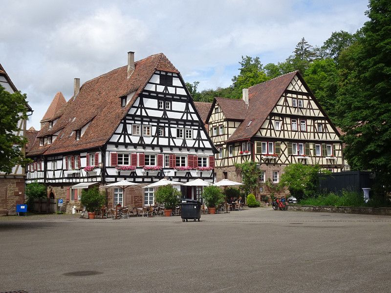
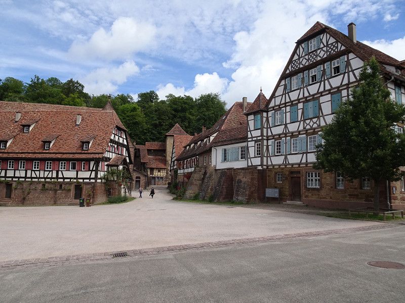
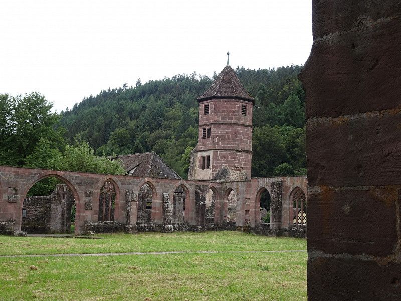
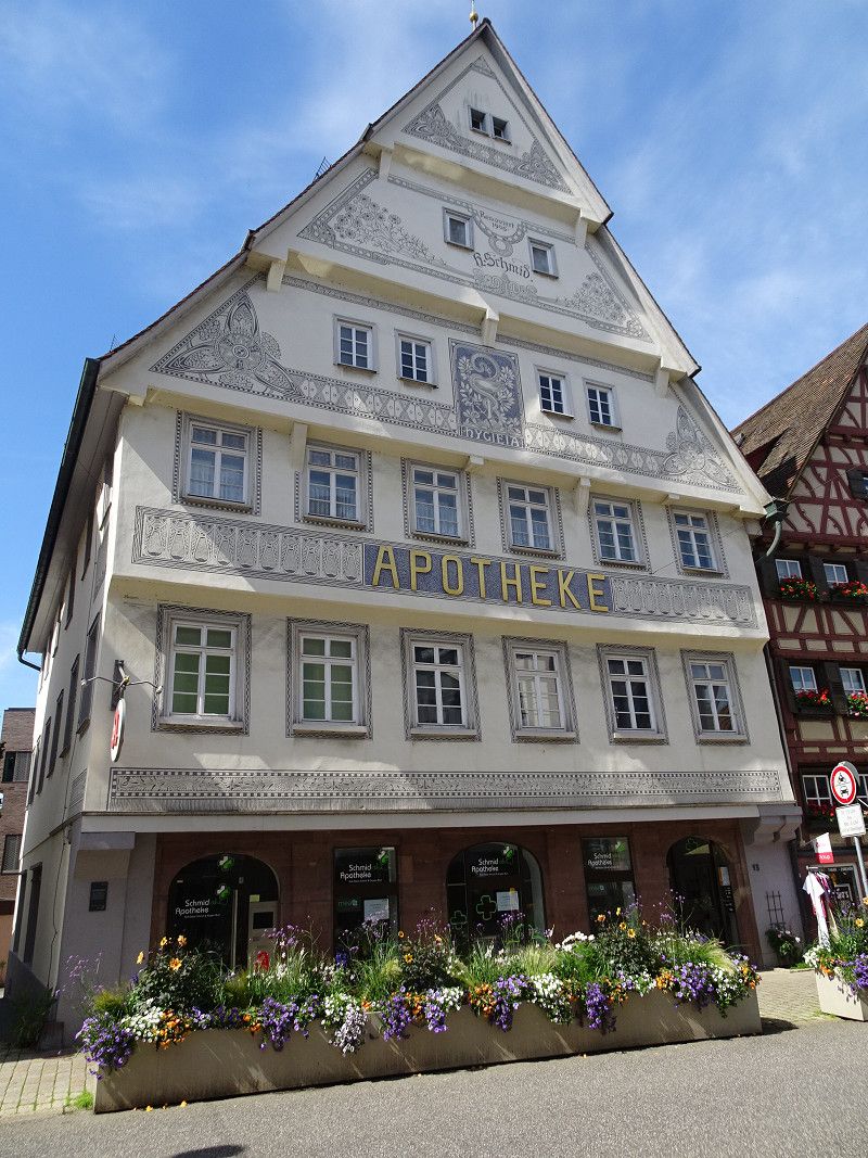
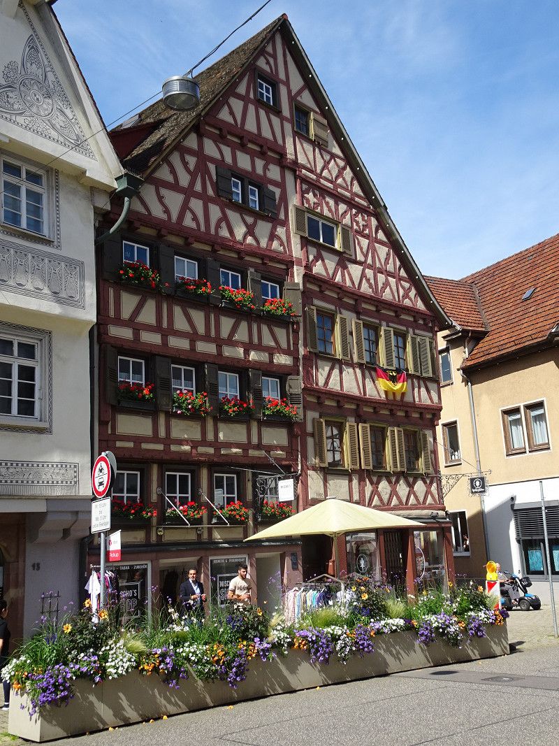
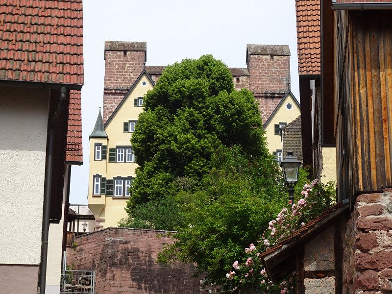
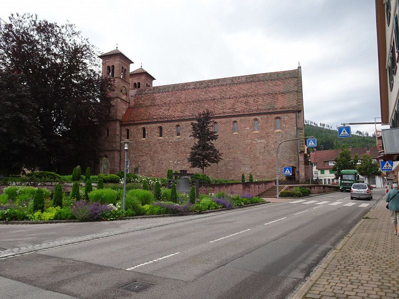
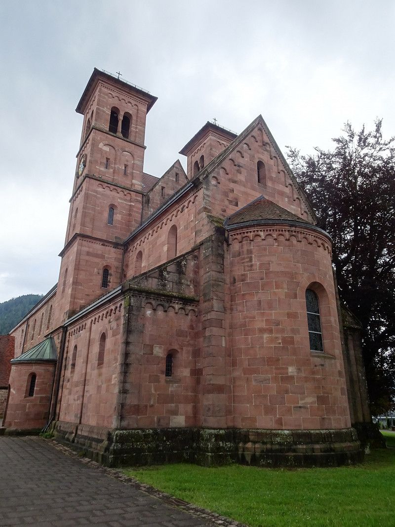
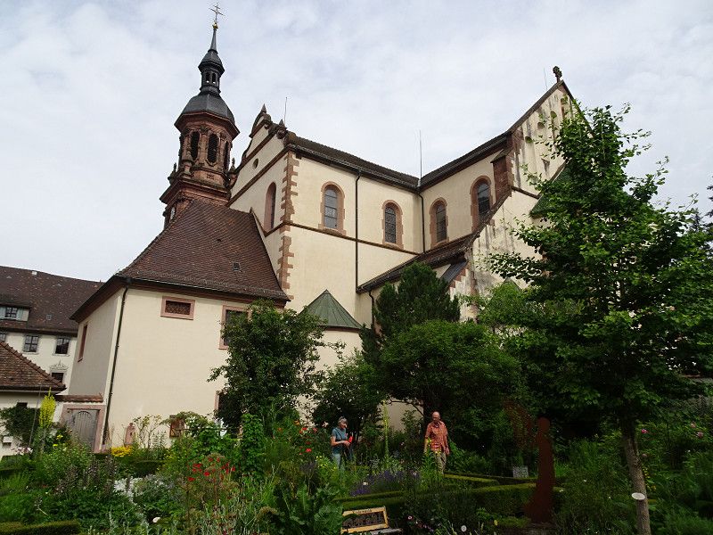
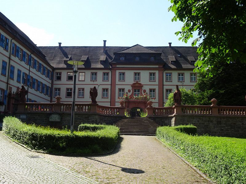
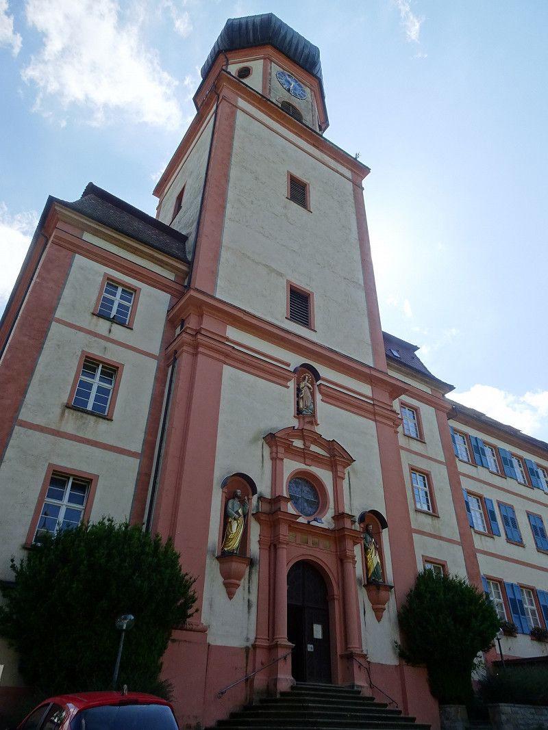
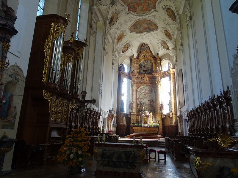
Basilika Ottobeuren
We visited the newly designed monastery museum, which gives a good insight into the daily routine of the monks and shows the development of the monastery. Afterwards, of course, a visit to the basilica is a must.
Day
Stellplatz Talaue am Kloster
Hilsenbeuerstraße/Talaue, 75433, Maulbronn, Germany
48° 59' 56.2" N 8° 48' 20.9" E
48.9989356 8.8058192
• Head toward Hilsenbeuerstraße on Talaue. Go for 61 m.
• Turn left onto Hilsenbeuerstraße. Go for 58 m.
• Take the 3rd exit from roundabout onto Frankfurter Straße (L1131). Go for 432 m.
• Turn left onto Klosterstraße. Go for 78 m.
• Turn right toward Klosterhof. Go for 44 m.
• Turn left onto Klosterhof. Go for 132 m.
• Turn left onto Klosterhof. Go for 65 m.
• Arrive at Klosterhof. Your destination is on the right.
☍
0,9 km
( 2 min.)
Day
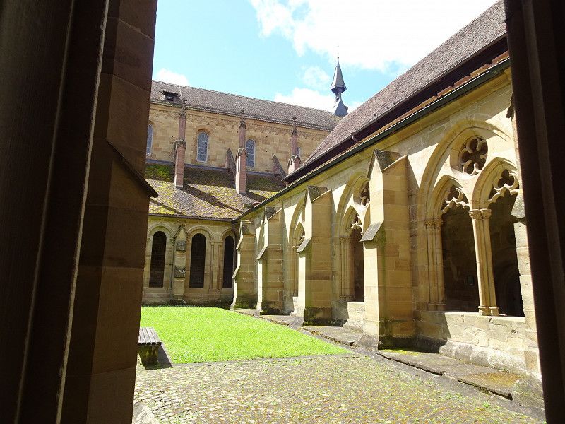
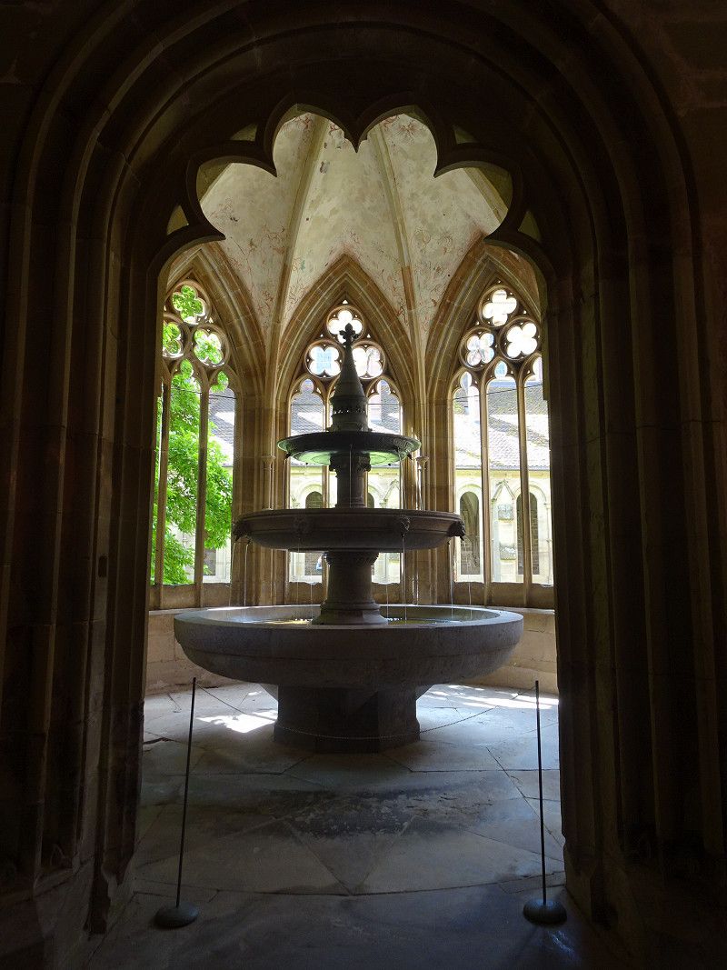
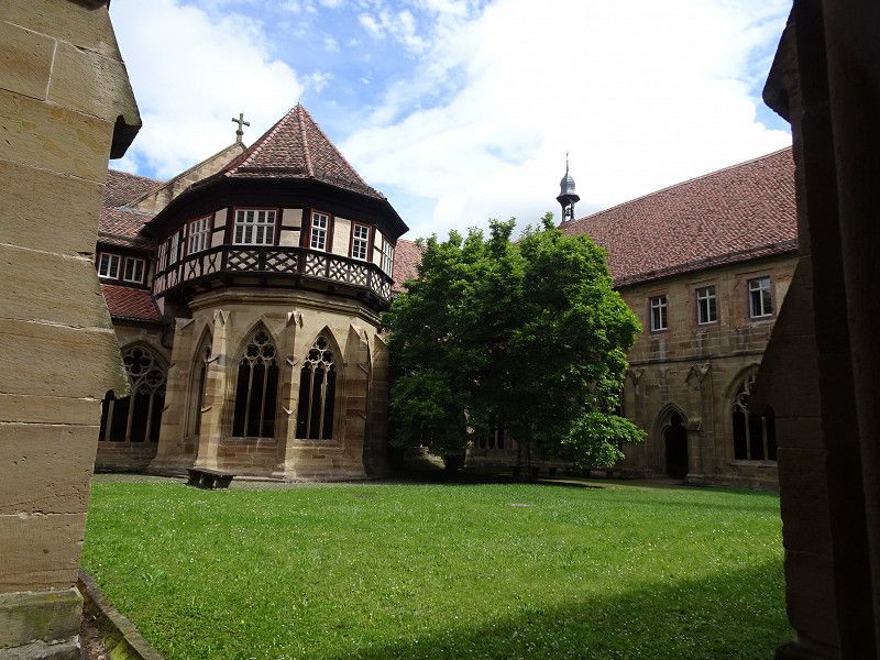
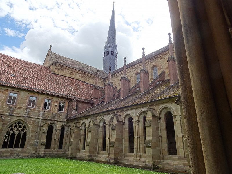
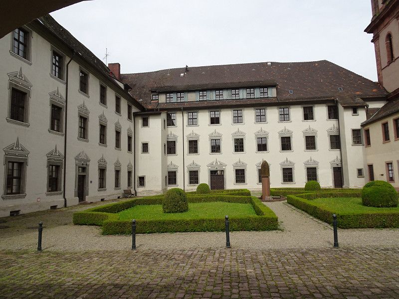
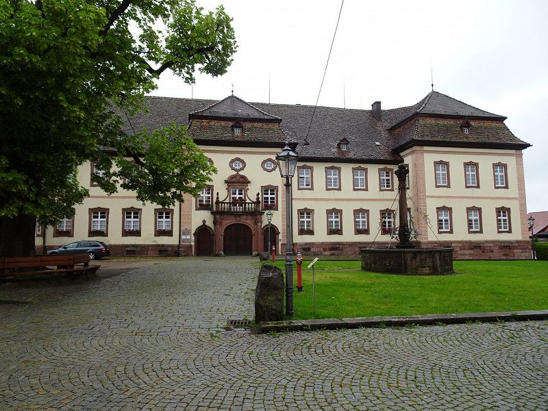
Maulbronn Monastery Klosterhof, Maulbronn, Deutschland
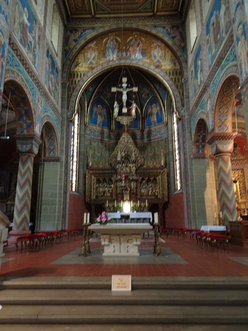
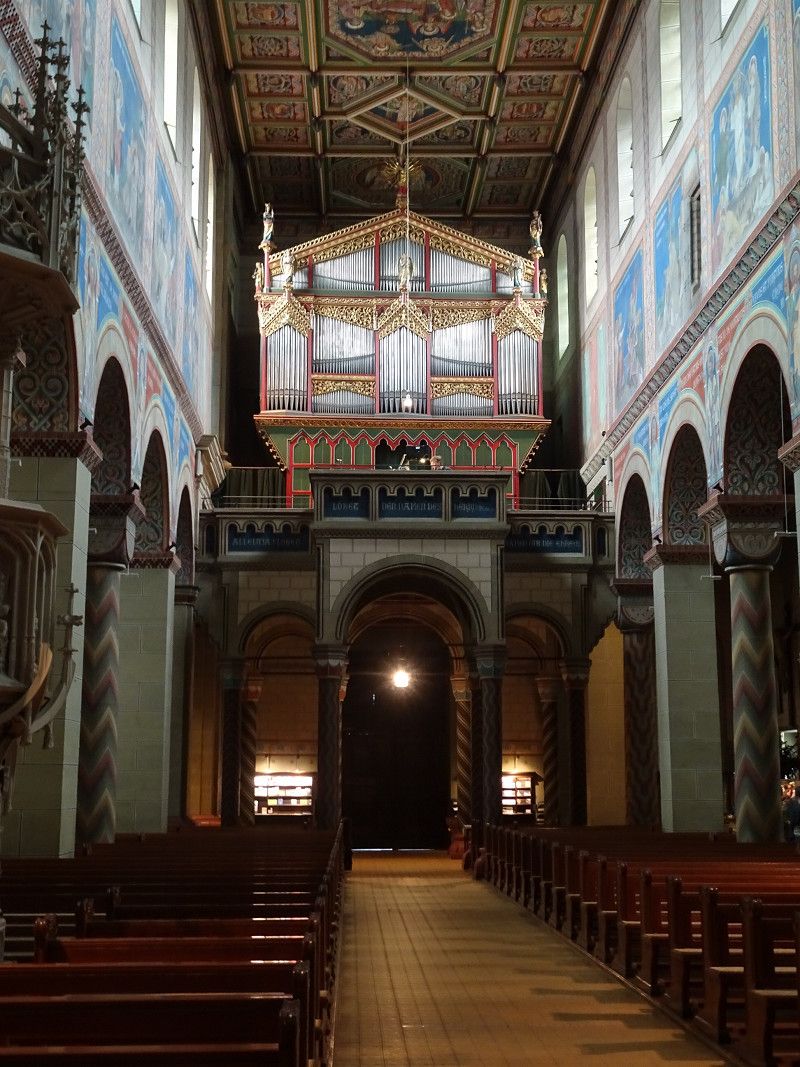
The UNESCO World Heritage monastery is to be understood as a total work of art.
Worth seeing are the Romanesque monastery church, the cloister and the
Delicate fountain house. The progression from Romanesque to Gothic is particularly evident in the cloister.
One should also not overlook the other buildings belonging to the monastery, such as the fruit box and others.
Hölderlin and Hesse also attended the school, which was established in 1806.
Klosterhof 5, 75433 Maulbronn, Deutschland
49° 0' 3.6" N 8° 48' 43.9" E
49.0010106 8.8121832
• Head southwest on Klosterhof. Go for 65 m.
• Turn right onto Klosterhof. Go for 132 m.
• Turn right. Go for 44 m.
• Turn left toward Klosterstraße. Go for 65 m.
• Continue on Klosterstraße. Go for 13 m.
• Turn right onto Stuttgarter Straße (L1131). Go for 380 m.
• Take the 2nd exit from roundabout onto Frankfurter Straße (L1131). Go for 671 m.
• Take the 3rd exit from roundabout onto Pforzheimer Straße (L1131). Go for 1.5 km.
• Continue on Maulbronn West (L611). Go for 134 m.
• Take the 1st exit from roundabout onto L611. Go for 2.9 km.
• Take the 3rd exit from roundabout onto Neulinger Straße (L611) toward A8/Pforzheim/Neulingen. Go for 2.3 km.
• Turn left onto Pforzheimer Straße (B294) toward A8/Pforzheim. Go for 8.9 km.
• Turn left onto Zähringerallee (B294) toward Stuttgart/A8/Stuttgart/Freudenstadt/Calw/Weil der Stadt/Zentrum. Go for 396 m.
• Turn right onto Christophallee (B294) toward Freudenstadt/Wildbad/Weil der Stadt/Calw/B463/Zentrum. Go for 553 m.
• Turn left onto Schloßberg toward Zentrum. Go for 355 m.
• Continue on Deimlingstraße. Go for 308 m.
• Continue on Auer Brücke. Go for 76 m.
• Continue on Kreuzstraße. Go for 108 m.
• Turn right onto Calwer Straße (L1135) toward Calw/Bad Liebenzell/Weil der Stadt. Go for 1.1 km.
• Turn right onto Hirsauer Straße (B463) toward Calw/Neuenhausen. Go for 22.7 km.
• Arrive at B463.
☍
42,6 km
( 47 min.)
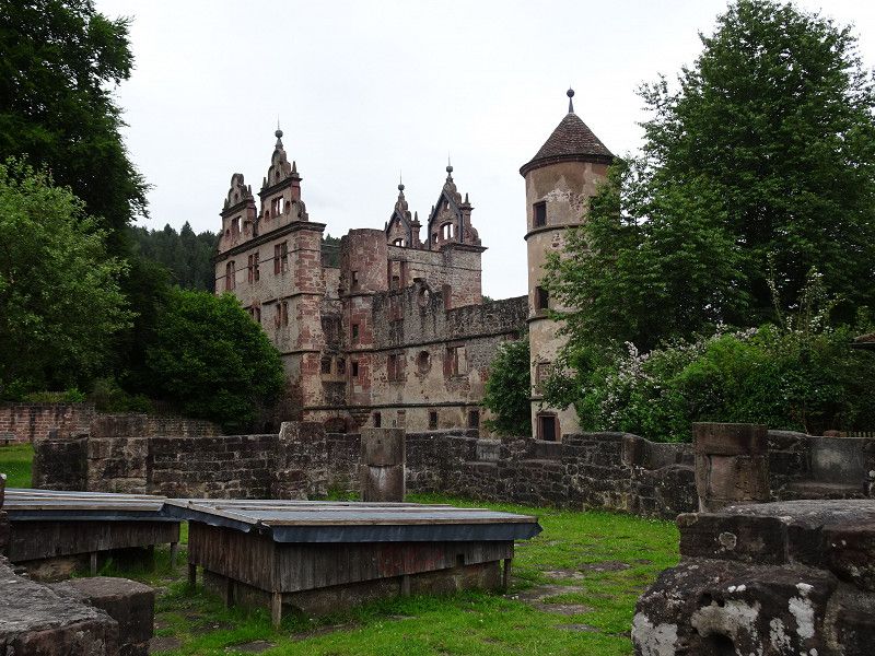
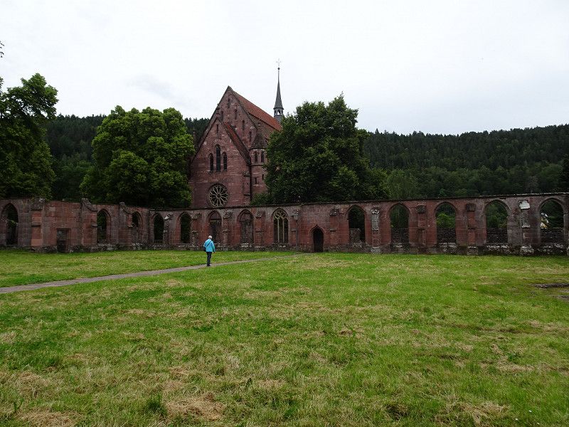
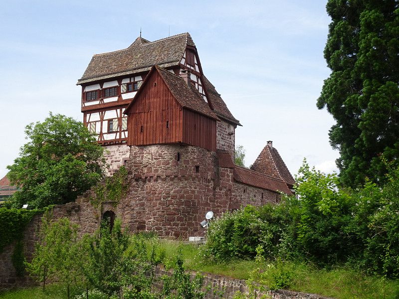
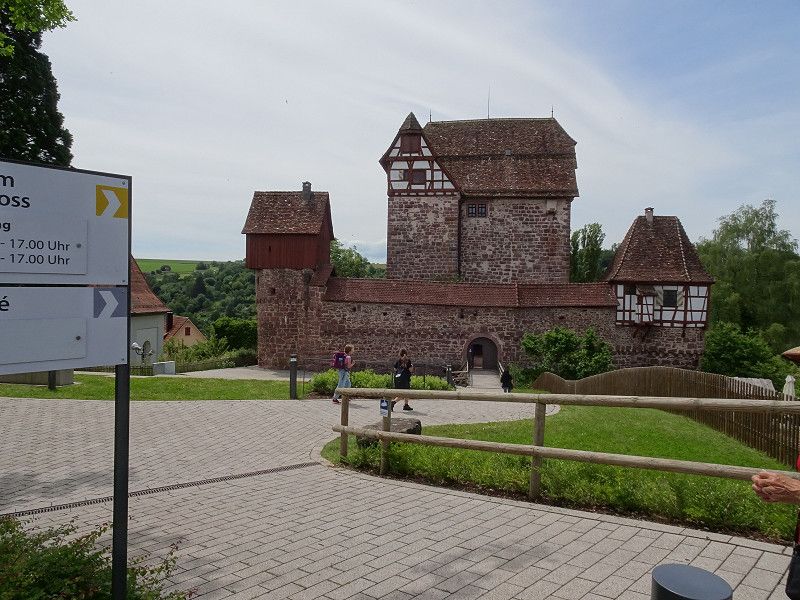
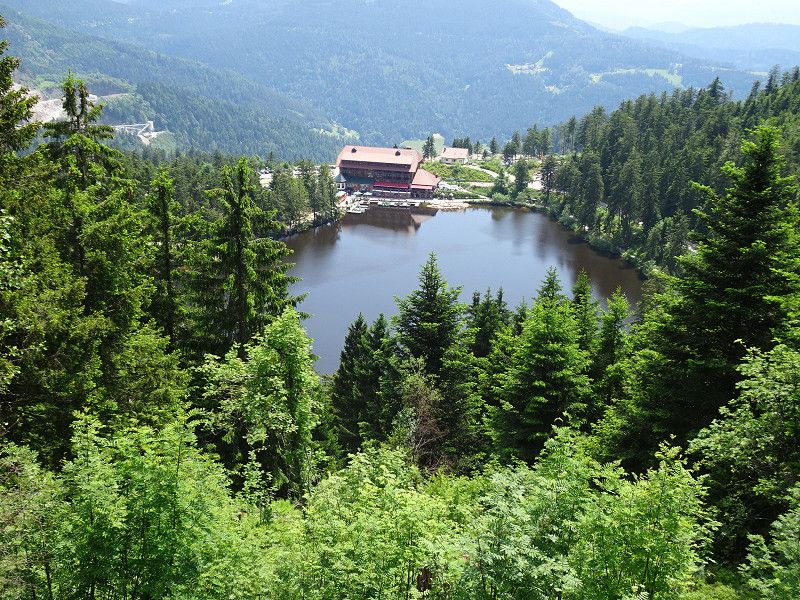
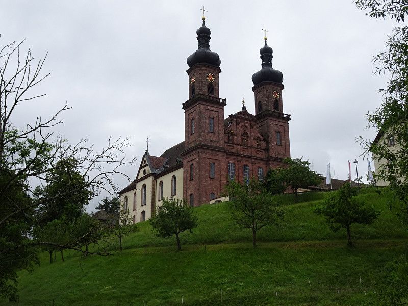
Hirsau, Calw, Deutschland
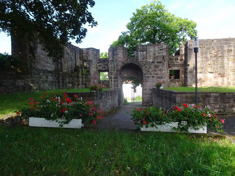
The ruins of Hirsau monastery, a former Benedictine monastery, leave a great impression, especially the rest of the cloister.
Only the Chapel of St. Mary is still functional. This is still used for church services today.
The burnt-out hunting lodge from the Baroque period complements the overall complex.
Hirsau, 75365 Calw, Deutschland
48° 44' 7.1" N 8° 44' 9" E
48.7352991 8.7358264
• Head toward Calwer Straße on B463. Go for 2.7 km.
• Turn right toward Nagold/Bad Teinach/Zavelstein. Go for 45 m.
• Arrive at your destination on the left.
☍
2,7 km
( 3 min.)
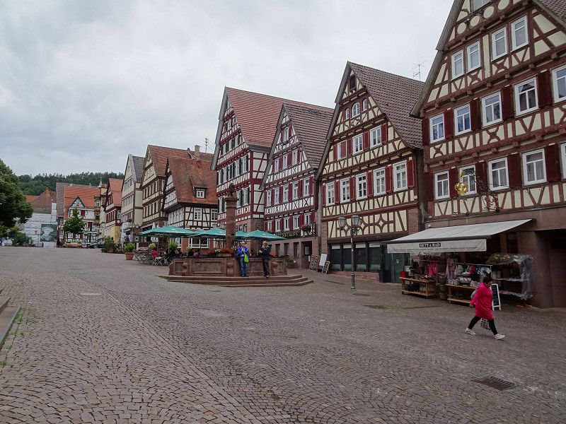
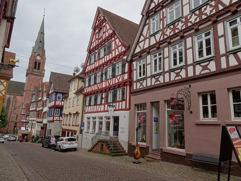
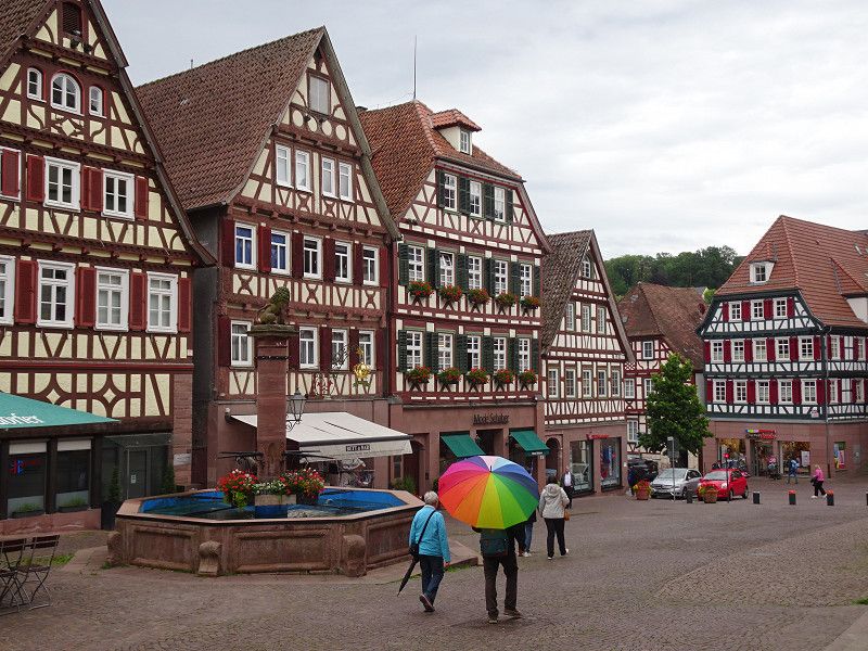
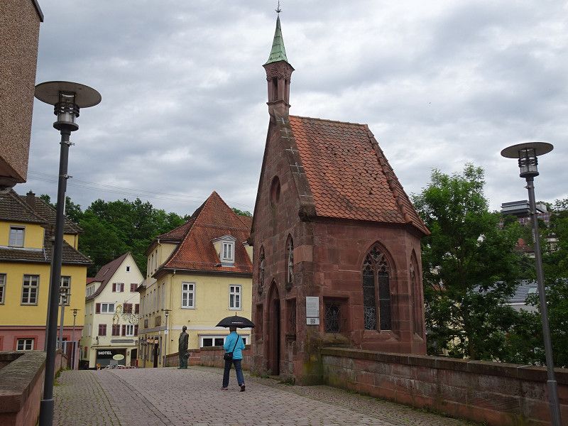
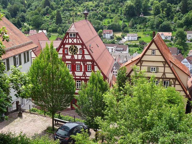
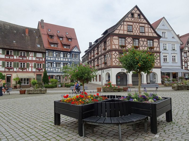
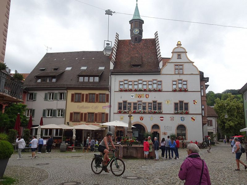
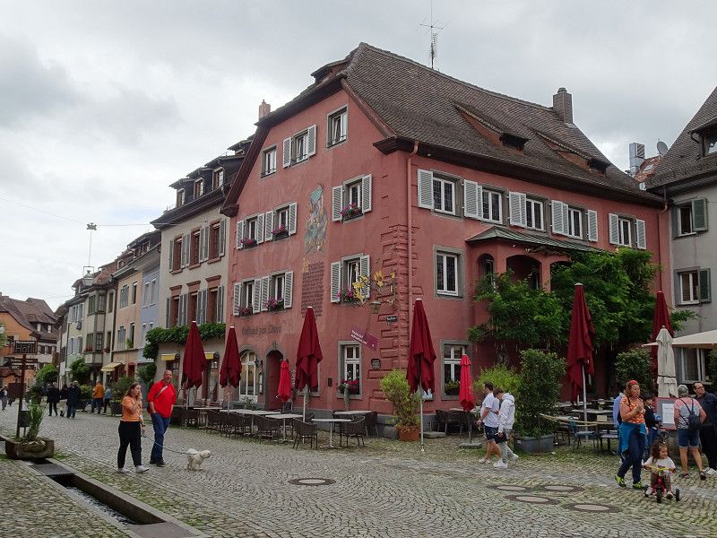
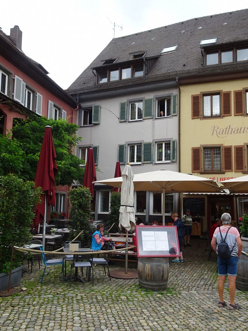
Calw, Deutschland
Pretty half-timbered buildings and narrow alleyways characterize the city center. The old town center with its picturesque market square and the town hall with its stepped gable are well worth seeing.
Calw is the hometown of Hermann Hesse. The Hermann Hesse Museum, which is currently being renovated, is located on the market square. The house where he was born has a clothing store on the ground floor. The Nikolaus Bridge leads over the Nagold to the Neustadt and features the Nikolaus Chapel and a bronze statue of Hermann Hesse.
75365 Calw, Deutschland
48° 42' 45.6" N 8° 44' 33.1" E
48.7126752 8.7425205
• Head southeast on Bahnhofstraße (B463).
• Turn right onto Bahnhofstraße (B463). Go for 349 m.
• Turn left toward Stuttgart/Herrenberg/CW-Stammheim/CW-Heumaden/Krankenhaus. Go for 110 m.
• Turn right onto Bahnhofstraße (B463) toward Stuttgart/Herrenberg/CW-Stammheim/CW-Heumaden/Krankenhaus. Go for 253 m.
• Turn right onto Stuttgarter Straße (B296) toward Stuttgart/Herrenberg/CW-Stammheim/CW-Heumaden/Krankenhaus. Go for 2.2 km.
• Turn right onto Tübinger Straße (B296) toward Singen/A81/Herrenberg/CW-Stammheim. Go for 901 m.
• Turn right onto Hauptstraße (K4303) toward CW-Stammheim. Go for 549 m.
• Arrive at Hauptstraße (K4303). Your destination is on the left.
☍
4,3 km
( 6 min.)
Camping Schwarzwaldblick
The Schwarzwaldblick campsite is located above the town. When I write above, I mean it. The climb from the town to the campsite is quite strenuous and sweaty on hot days.
The site only has a few spaces for day visitors. It was enough for us.
Weidensteige 54/1, 75365, Calw, Germany
48° 41' 49" N 8° 45' 50" E
48.6969400 8.7638800
• Head toward Mühläckerstraße on Hauptstraße (K4303). Go for 445 m.
• Turn right onto Herrenberger Straße (K4303). Go for 416 m.
• Continue on Holzbronner Straße (K4303). Go for 233 m.
• Continue on K4303. Go for 1.2 km.
• Turn right onto K4302. Go for 5.7 km.
• Turn right onto B463. Go for 739 m.
• Take ramp onto Station Teinach (L348). Go for 974 m.
• Take the 3rd exit from roundabout onto Kentheimer Straße (L347). Go for 143 m.
• Turn left onto Neubulacher Straße (L348). Go for 7.1 km.
• Turn left onto L349. Go for 6.5 km.
• Turn left onto Bulacher Weg. Go for 85 m.
• Turn slightly right onto Dr.-Vesenmayer-Weg. Go for 211 m.
• Arrive at Dr.-Vesenmayer-Weg. Your destination is on the right.
☍
23,8 km
( 22 min.)
Day
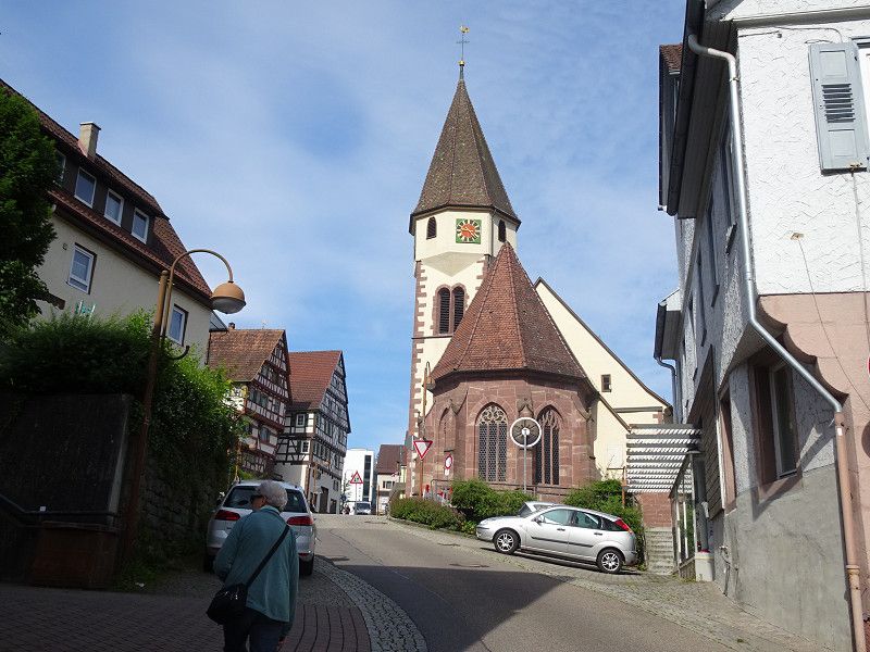
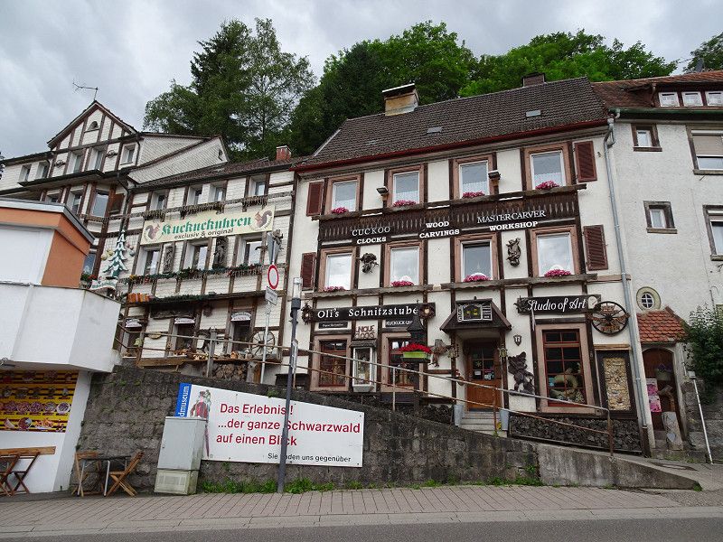
Wildberg, Deutschland
The medieval town on the Nagold and the castle ruins on the mountain spur have to be climbed on foot. The access road is a bit too narrow for a camper van. However, the walk provides some variety and exercise.
Parking spaces can be found along the main road in the form of parallel parking spaces.
72218 Wildberg, Deutschland
48° 37' 28.7" N 8° 44' 27.9" E
48.6246322 8.7410966
• Head toward Bulacher Weg on Dr.-Vesenmayer-Weg. Go for 211 m.
• Turn slightly left onto Bulacher Weg. Go for 43 m.
• Turn slightly left onto Marktstraße. Go for 72 m.
• Turn left onto Marktstraße (L349). Go for 43 m.
• Turn right onto Marktstraße. Go for 15 m.
• Turn right onto Kochsteige. Go for 271 m.
• Turn right onto Talstraße (B463). Go for 10.1 km.
• Turn left onto Lange Straße (B463) toward Gewerbegebiet Wolfsberg/INGpark/Krankenhaus. Go for 545 m.
• Take the 2nd exit from roundabout onto Wolfsbergtunnel (B463) toward Horb. Go for 327 m.
• Take the 2nd exit from roundabout onto Grafenwiesenstraße toward Altensteig/Krankenhaus/Gewerbegebiet Nagold-West. Go for 199 m.
• Take the 2nd exit from roundabout onto Grafenwiesenstraße toward Altensteig/Krankenhaus/Gewerbegebiet Nagold-West. Go for 285 m.
• Take the 3rd exit from roundabout onto Freudenstädter Straße toward Altensteig/Industriegebiet Nagold-West. Go for 125 m.
• Turn left onto Kronenstraße. Go for 31 m.
• Turn left toward Obere Eisenbahnstraße. Go for 87 m.
• Turn right onto Obere Eisenbahnstraße. Go for 142 m.
• Arrive at Obere Eisenbahnstraße. Your destination is on the right.
☍
12,5 km
( 14 min.)
Nagold, Deutschland
A few beautiful half-timbered houses can be seen. After Calw and Wildberg, Nagold is a bit disappointing, with many new houses placed rather insensitively between the old buildings. Many houses were probably destroyed in the war and the rest were taken care of during the economic boom.
72202 Nagold, Deutschland
48° 32' 50.7" N 8° 43' 24.5" E
48.5474083 8.7234746
• Head south on Obere Eisenbahnstraße. Go for 66 m.
• Turn right onto Lembergstraße. Go for 24 m.
• Turn right onto Moltkestraße. Go for 537 m.
• Take the 2nd exit from roundabout onto Altensteiger Straße toward Freudenstadt/Altensteig/Gewerbepark N-West. Go for 366 m.
• Take the 1st exit from roundabout onto L362 toward Freudenstadt/Altensteig/Haiterbach. Go for 2.1 km.
• Take the 1st exit from roundabout onto L362 toward Freudenstadt/Altensteig/Ebhausen/Rohrdorf. Go for 8.7 km.
• Turn right onto Warter Straße (L348) toward Neuweiler/Wart/Berneck. Go for 124 m.
• Turn left onto Hauptstraße (K4371) toward Berneck. Go for 934 m.
• Arrive at Marktplatz (K4371). Your destination is on the right.
☍
12,9 km
( 13 min.)
Berneck, Altensteig
The small town is located on a mountain spur and is crowned by a remarkable medieval shield wall. The climb brings a bit of movement to the excursion and makes the heart beat faster in two ways. The castle has disappeared and has been replaced by a residential building with an aristocratic flair, but this is not a problem.
Marktplatz 4, Altensteig, Landkreis Calw, Baden-Württemberg, Deutschland
48° 36' 10.4" N 8° 37' 1.6" E
48.6028929 8.6171194
• Head toward Neue Straße on Marktplatz (K4371). Go for 934 m.
• Turn right onto Warter Straße (L348). Go for 124 m.
• Turn right onto Nagolder Straße (L362). Go for 1.2 km.
• Pass 2 roundabouts and continue on Postplatz (L362). Go for 1.6 km.
• Turn right onto Karlstraße (K4334). Go for 810 m.
• Turn left onto Dorfer Straße (K4334). Go for 185 m.
• Turn right onto Welkerstraße. Go for 185 m.
• Continue on Speidelstraße. Go for 42 m.
• Turn left onto Lerchenstraße. Go for 141 m.
• Arrive at Lerchenstraße. Your destination is on the right.
☍
5,2 km
( 8 min.)
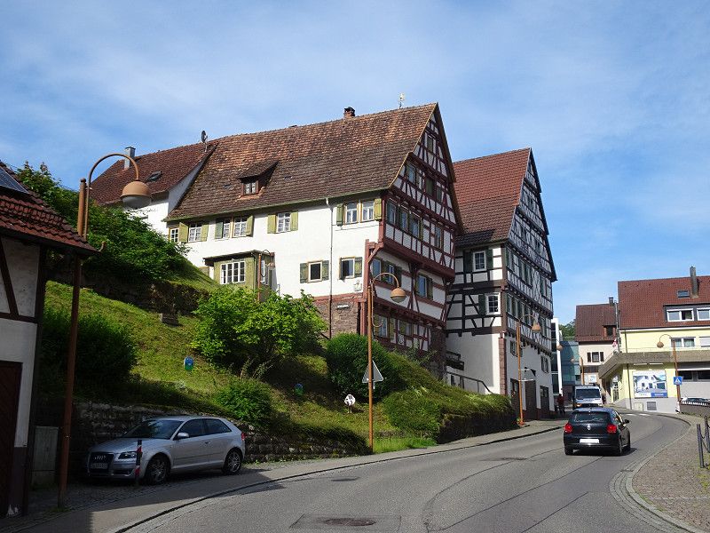
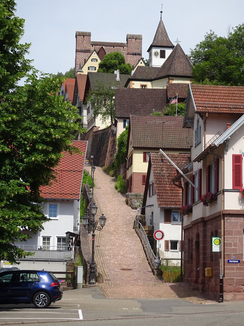
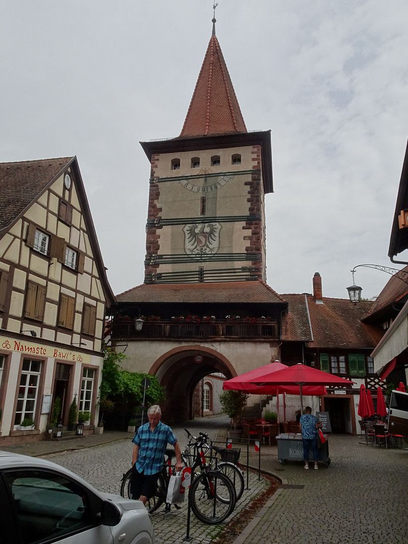
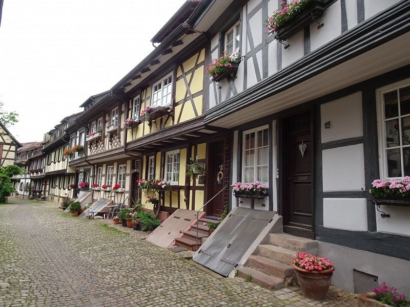
Altensteig, Deutschland
As the name suggests, the "Steig" plays an important role here. It goes up again. You can drive up with the camper van and try to park at the schoolhouse. You will then be right at the new castle, and a little further down you will see the town church and the town hall.
However, you can also park down by the shops on the main road and then walk up to the old town.
You then go down via various stairs. If you visit the old town on foot, you can make some discoveries.
72213 Altensteig, Deutschland
48° 35' 18.2" N 8° 36' 21.8" E
48.5883792 8.6060633
• Head north on Lerchenstraße.
• Turn left onto Lerchenstraße. Go for 56 m.
• Turn left onto Burgstraße. Go for 148 m.
• Turn right onto Welkerstraße. Go for 169 m.
• Turn left onto Dorfer Straße (K4334). Go for 185 m.
• Turn right onto Karlstraße (K4334). Go for 810 m.
• Turn right onto Poststraße (L362) toward Freudenstadt/Spielberg. Go for 300 m.
• Turn right onto Gustav-Werner-Straße (L362). Go for 449 m.
• Turn left onto Obere Talstraße (L362). Go for 1.4 km.
• Arrive at Im Oberen Tal (L362). Your destination is on the left.
☍
3,5 km
( 6 min.)
Schwarzwald Camping Altensteig
A nice and large campsite, beautifully situated on the Nagold and to the left and right of it. The sanitary facilities are state-of-the-art.
Im Oberen Tal 3-5, 72213, Altensteig, Germany
48° 35' 5.1" N 8° 34' 43.6" E
48.5847600 8.5787800
• Head west on Im Oberen Tal (L362). Go for 11.1 km.
• Take the 2nd exit from roundabout onto L362. Go for 158 m.
• Turn left onto Nagoldtalstraße (L362). Go for 3.9 km.
• Turn left onto B294 toward Freudenstadt. Go for 855 m.
• Turn right onto L409 toward Baiersbronn/Klosterreichenbach. Go for 4.0 km.
• Turn left onto Murgtalstraße (B462). Go for 3.2 km.
• Take the 3rd exit from roundabout onto Freudenstädter Straße (B462) toward Freudenstadt. Go for 397 m.
• Arrive at Freudenstädter Straße (B462). Your destination is on the left.
☍
23,6 km
( 22 min.)
Day
Baiersbronn
Former Reichenbach Monastery, a little north of Baiersbronn, with only one remaining historical building: a Romanesque monastery church in all its grace and without much frills.
Baiersbronn itself is a former rafting village. We just drove through there.
Landkreis Freudenstadt, Baden-Württemberg, Deutschland
48° 30' 25" N 8° 22' 19.2" E
48.5069519 8.3720124
• Head toward Forbachstraße on Freudenstädter Straße (B462). Go for 6.4 km.
• Turn right onto Marktplatz (B462) toward Straßburg/B28/Stuttgart/Freiburg/B294. Go for 78 m.
• Turn left onto Marktplatz (B28/B462) toward Stuttgart/Freiburg/B294. Go for 517 m.
• Arrive at Stuttgarter Straße (B28/B462). Your destination is on the right.
☍
7,0 km
( 8 min.)
Freudenstadt, Deutschland
Here we only visited the largest market place in Germany. We found a parking space right on the square.
72250 Freudenstadt, Deutschland
48° 27' 52.1" N 8° 25' 4.8" E
48.4644796 8.4179988
• Head northeast on Stuttgarter Straße (B28/B462). Go for 22 m.
• Turn left onto Ringstraße. Go for 254 m.
• Turn left onto Blaicherstraße. Go for 137 m.
• Turn right onto Stuttgarter Straße (B28/B462). Go for 256 m.
• Turn left onto Loßburger Straße (B28) toward Straßburg. Go for 321 m.
• Take the 1st exit from roundabout onto Straßburger Straße (B28) toward Strasbourg/Baden-Baden/Kniebis. Go for 11.9 km.
• Turn right onto Schwarzwaldhochstraße (B500) toward Baden-Baden/Ruhestein. Go for 13.2 km.
• Enter the roundabout. Go for 87 m.
• Arrive at your destination on the left.
☍
26,2 km
( 21 min.)
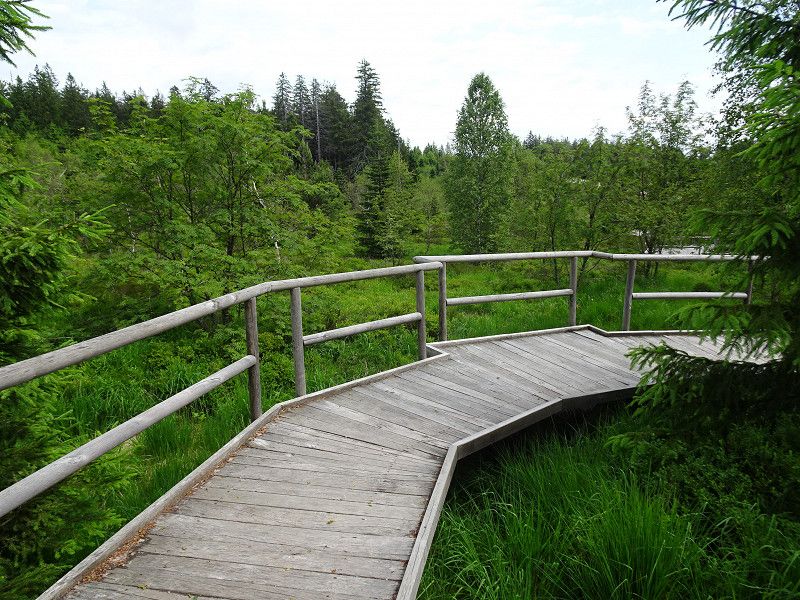
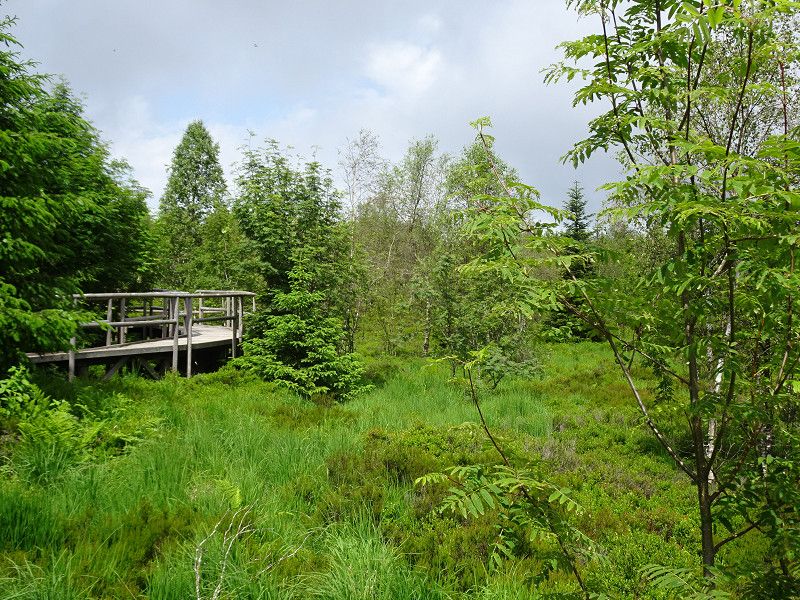
Nationalparkzentrum Ruhestein und Lotharpfad
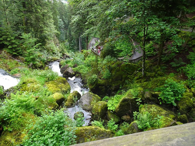
The B500 is the highlight of a visit to the Black Forest. The road offers many beautiful views and is also equipped with many stopping bays and parking spaces.
First we went to the Lothar Trail. There is an educational trail here that shows what was and is being "repaired" by nature after the storm in December 1999.
We didn't visit the nature conservation center. We were just looking for a restaurant for lunch and found one at the valley station of the ski lift opposite, the Ruhestein-Schänke.
Nationalparkzentrum Ruhestein, 77889 Seebach, Deutschland
48° 33' 41.1" N 8° 13' 16.1" E
48.5614285 8.2211423
• Follow the roundabout. Go for 74 m.
• Take the 4th exit from roundabout onto Schwarzwaldhochstraße (B500) toward Baden-Baden/Unterstmatt/Mummelsee. Go for 6.2 km.
• Turn right onto Hornisgrinde (L81). Go for 1.5 km.
• Continue on L81. Go for 46 m.
• Turn right. Go for 52 m.
• Keep right. Go for 66 m.
• Arrive at your destination.
☍
7,9 km
( 9 min.)
Hornisgrinde, Sasbach, Deutschland
The hike from Mummelsee to Hornisgrinde is a must. You should allow yourself 50 minutes to climb and 40 minutes to descend. A stop at the restaurant on the summit is recommended. Unfortunately, the observation tower is currently closed due to upcoming renovation work.
Afterwards you can stroll and shop in the souvenir shops at Mummelsee.
Hornisgrinde, 77887 Sasbach, Deutschland
48° 36' 16" N 8° 12' 7" E
48.6044444 8.2019444
• Head southeast. Go for 118 m.
• Turn left onto L81. Go for 46 m.
• Continue on Hornisgrinde (L81). Go for 1.5 km.
• Turn right onto Schwarzwaldhochstraße (B500). Go for 3.3 km.
• Turn left onto L86 toward Achern/Sasbachwalden. Go for 9.7 km.
• Arrive at Talstraße (L86). Your destination is on the left.
☍
14,7 km
( 18 min.)
Wohnmobilstellplatz Sasbachwalden
Well-equipped campsite with 33 pitches in the centre of the attractive town. Walking path along the river next to the campsite.
Talstraße 2, 77887, Sasbachwalden, Germany
48° 37' 12" N 8° 7' 8" E
48.6200000 8.1188889
• Head west on Talstraße (L86). Go for 3.2 km.
• Take the 3rd exit from roundabout onto Hauptstraße (L86). Go for 938 m.
• Continue on Fautenbacher Straße. Go for 855 m.
• Take the 4th exit from roundabout toward Rheinau. Go for 292 m.
• Turn right onto L87 toward Rheinau. Go for 2.8 km.
• Take the 1st exit from roundabout onto L87 toward Gambsheim/Rheinau/Basel/A5. Go for 266 m.
• Take the 1st exit from roundabout onto A5 toward Basel. Go for 21.7 km.
• Take exit 55 toward Offenburg/Villingen-Schwenningen/B33/Gengenbach/Kinzigtal onto B33A. Go for 338 m.
• Keep left onto B33A toward Basel/A5/Villingen-Schwenningen/B33/Gengenbach/Kinzigtal/Offenburg. Go for 442 m.
• Keep right onto B33A toward Villingen-Schwenningen/B33/Gengenbach/Kinzigtal/Offenburg. Go for 1.8 km.
• Take ramp onto B3 toward Villingen-Schwenningen/Lahr/Biberach/Kinzigtal/Gengenbach/OG Ost/Süd/Gewerbegebiet Elgersweier/Messe/B33. Go for 1.7 km.
• Keep right onto B33 toward Villingen-Schwenningen/Biberach/Kinzigtal/Gengenbach/Gewerbegebiet Elgersweier-Nord. Go for 6.1 km.
• Take ramp toward Gengenbach-Nord/Zentrum/Gewerbegebiet Kinzigpark/Allmend/Berghaupten. Go for 278 m.
• Continue on Flößerbrücke. Go for 86 m.
• Continue on Nordspange. Go for 796 m.
• Take the 1st exit from roundabout onto Alte Landstraße (L99) toward Gengenbach/Krankenhaus Zentrum/Gewerbegebiet Allmend. Go for 1.4 km.
• Turn left onto Parkweg. Go for 71 m.
• Turn slightly left onto Parkweg. Go for 325 m.
• Turn left onto Parkweg. Go for 53 m.
• Arrive at Parkweg. Your destination is on the right.
☍
43,4 km
( 32 min.)
Day
Gengenbach, Deutschland
The historic town centre, still partly surrounded by a defensive wall, includes a monastery and its church.
At the tourist office you can get a city map with a suggested tour of the city. This way you won't miss any sights and you will get background information.
We really liked this little town.
We parked at the sports fields, next to the small restaurant. Coord. 48.39926/8.02162. From there, a narrow footpath leads along a stream to the bridge over the Kinzig.
77723 Gengenbach, Deutschland
48° 24' 35.3" N 8° 0' 34.6" E
48.4098117 8.0095997
• Head northeast on Parkweg. Go for 53 m.
• Turn right onto Parkweg. Go for 396 m.
• Turn left onto Leutkirchstraße (L99). Go for 391 m.
• Turn right onto Friedrichstraße (L99). Go for 357 m.
• Turn right onto L99. Go for 14 m.
• Continue on Brückenhäuserstraße (L99). Go for 1.2 km.
• Turn right onto Brückenhäuserstraße (L99). Go for 437 m.
• Turn right and take ramp onto B33 toward Villingen-Schwenningen/Biberach. Go for 7.0 km.
• Take ramp toward Lahr/Oberharmersbach/Nordrach/Zell a.H./Biberach-Süd Gewerbegebiet. Go for 302 m.
• Turn right onto B415 toward Oberharmersbach/Nordrach/Zell a.H./Biberach/Offenburg. Go for 320 m.
• Continue on L94 toward Zell a.H./Biberach. Go for 663 m.
• Pass 3 roundabouts and continue on Hauptstraße (L94). Go for 3.2 km.
• Arrive at Hauptstraße (L94). Your destination is on the right.
☍
14,3 km
( 14 min.)
Zell am Harmersbach, Deutschland
An idyllic Black Forest town with a historic old town and the former commercial porcelain factories.
This is where the dishes with the rooster and hen come from. Unfortunately, we couldn't find any such dishes anywhere. What a pity! Even the outlet store was empty.
It is also a pity that all traffic is routed through the old town.
77736 Zell am Harmersbach, Deutschland
48° 20' 49.8" N 8° 3' 56.4" E
48.3471573 8.0656529
• Head east on Hauptstraße (L94). Go for 39 m.
• Turn right onto Turmstraße. Go for 35 m.
• Continue on Spitalstraße. Go for 9 m.
• Turn right onto Hauptstraße. Go for 30 m.
• Turn left onto Hauptstraße (L94). Go for 272 m.
• Take the 2nd exit from roundabout onto Hauptstraße (L94). Go for 132 m.
• Turn left onto Unterentersbacher Straße (K5354). Go for 523 m.
• Take the 2nd exit from roundabout onto Unterentersbacher Straße (K5354). Go for 99 m.
• Continue on K5354. Go for 1.8 km.
• Continue on Stöcken (K5354). Go for 527 m.
• Continue on K5354. Go for 26 m.
• Continue on Stöcken (K5354). Go for 52 m.
• Take the 2nd exit from roundabout onto Stöcken (K5356). Go for 241 m.
• Continue on K5356. Go for 1.3 km.
• Continue on Hauptstraße (K5356). Go for 1.5 km.
• Turn right onto Welschensteinacher Straße (L103). Go for 748 m.
• Turn right onto Welschensteinacher Straße. Go for 118 m.
• Arrive at Welschensteinacher Straße. Your destination is on the left.
☍
7,5 km
( 9 min.)
Camping Kinzigtal
There is the campsite and opposite there is an area with rental accommodation. Both are firmly in Dutch hands.
We were on the big campsite in area D. Completely alone!
Welschensteinacherstraße 34, 77790, Steinach, Germany
48° 17' 43.6" N 8° 2' 50.4" E
48.2954400 8.0473200
• Head southeast on Welschensteinacher Straße. Go for 118 m.
• Turn left onto Welschensteinacher Straße (L103). Go for 748 m.
• Turn right onto Haslacher Straße (K5358). Go for 1.9 km.
• Turn right onto Haslacher Straße (B33). Go for 11.7 km.
• Turn right onto Rotbauernhof. Go for 173 m.
• Turn right onto Mattenhof. Go for 350 m.
• Arrive at Mattenhof. Your destination is on the left.
☍
15,0 km
( 15 min.)
Day
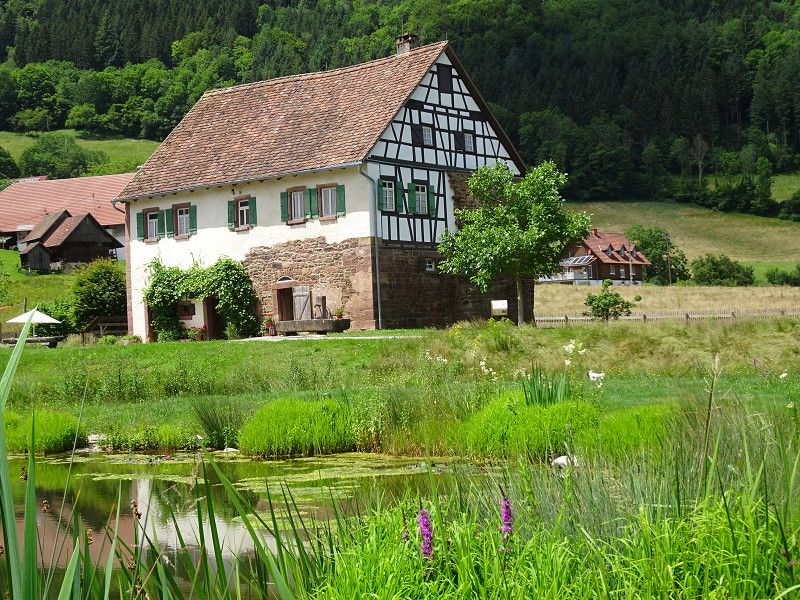
Vogtsbauernhof, Gutach (Schwarzwaldbahn), Deutschland
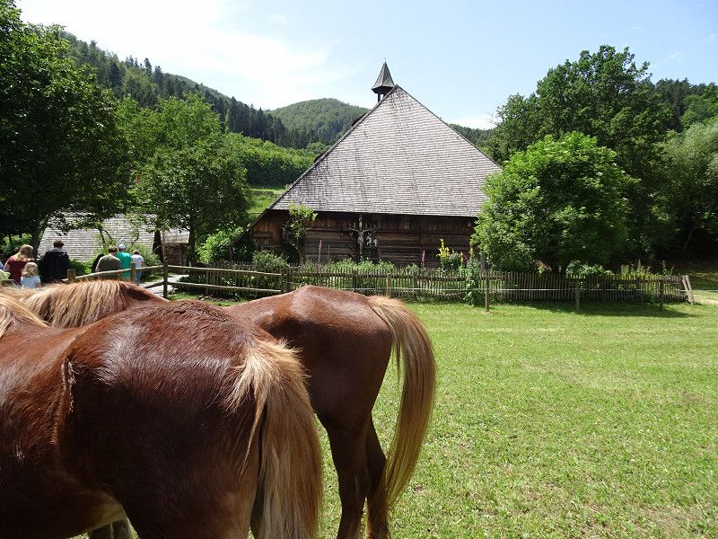
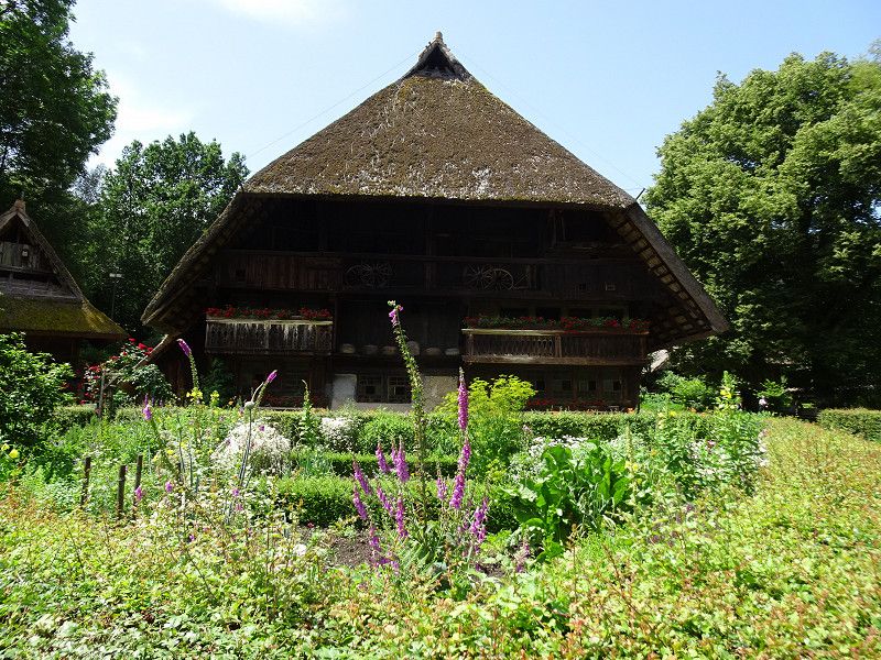
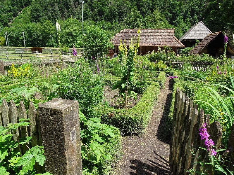
Open-air museum with farmhouses from the Black Forest. A visit is definitely recommended. We spent half a day in this museum.
Vogtsbauernhof, 77793 Gutach (Schwarzwaldbahn), Deutschland
48° 16' 14.9" N 8° 11' 53.2" E
48.2707989 8.1981011
• Head southeast on Mattenhof. Go for 350 m.
• Turn left onto Rotbauernhof. Go for 173 m.
• Turn right onto Vor Singersbach (B33). Go for 4.0 km.
• Arrive at Steingrün (B33). Your destination is on the left.
☍
4,5 km
( 5 min.)
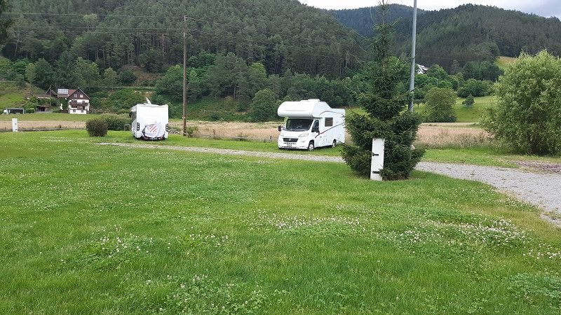
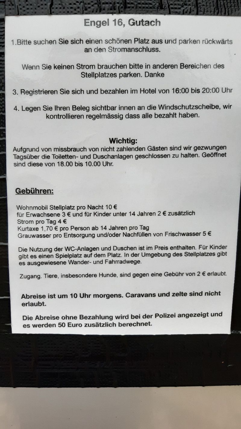
Engel 16, Gutach
New parking space on a meadow behind the Hotel Engel. Far enough away from the road, it's a good place to rest.
Steingrün 16, Gutach, Germany
48° 14' 4.1" N 8° 12' 53.8" E
48.2344730 8.2149520
• Head southeast on Steingrün (B33). Go for 11.9 km.
• Turn right onto Frejusstraße (B500) toward Furtwangen/Schönwald/Elzach/Schonach/Stadtmitte. Go for 749 m.
• Turn right onto Bruelweg. Go for 50 m.
• Arrive at Bruelweg. Your destination is on the left.
☍
12,7 km
( 13 min.)
Day
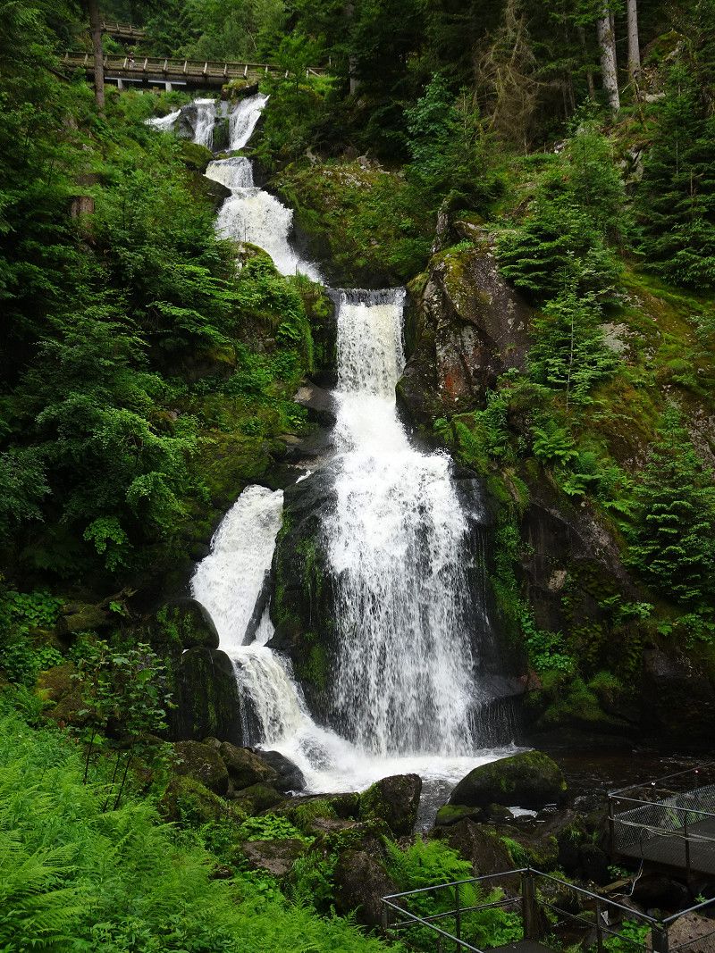
Triberg im Schwarzwald
Here we were particularly interested in the highest waterfall. However, this is divided into different levels. We paid the entrance fee and climbed up the stream. Once at the top, we descended along the nature and panoramic path to the mountain lake and the pilgrimage church.
We parked at the train station. But Edeka also has parking spaces for motorhomes.
Hauptstraße 14a, Triberg im Schwarzwald, Schwarzwald-Baar-Kreis, Baden-Württemberg, Deutschland
48° 7' 59.6" N 8° 13' 59.5" E
48.1332280 8.2331937
• Head toward Hauptstraße on Bruelweg. Go for 50 m.
• Turn right onto Hauptstraße (B500). Go for 595 m.
• Turn left onto Ludwigstraße (K5727). Go for 126 m.
• Continue on Friedrichstraße (K5727). Go for 261 m.
• Continue on Rohrbacher Straße (K5727). Go for 885 m.
• Continue on Geutschenstraße (K5727). Go for 1.7 km.
• Continue on K5727. Go for 683 m.
• Continue on Geutschenstraße (K5727). Go for 440 m.
• Continue on K5727. Go for 395 m.
• Turn left onto K5728. Go for 485 m.
• Continue on Fuchsfallenweg (K5728). Go for 903 m.
• Turn left and take ramp toward St. Georgen/Brigach/Furtwangen/Rohrbach. Go for 178 m.
• Turn right onto L175. Go for 6.6 km.
• Turn right onto Alemannenstraße (L173). Go for 2.6 km.
• Turn left onto Martin-Schmitt-Straße (L173). Go for 1.8 km.
• Turn left onto Bregstraße (B500). Go for 419 m.
• Take the 3rd exit from roundabout onto B500. Go for 2.3 km.
• Turn left onto Oberbregenbach (B500) toward Titisee-Neustadt/Hinterzarten/Neukirch. Go for 13.6 km.
• Turn right onto Thurner (L128) toward St. Peter/St. Märgen. Go for 6.2 km.
• Turn right onto Glottertalstraße (L127). Go for 6.5 km.
• Continue on L112. Go for 568 m.
• Turn right onto Haldenweg. Go for 167 m.
• Arrive at Haldenweg. Your destination is on the left.
☍
47,6 km
( 43 min.)
Camping Steingrubenhof
This site is mainly used by permanent campers. But tourists are also very welcome. The sanitary facilities are new and heated.
Haldenweg 3, 79271, St. Peter, Deutschland
48° 1' 23.8" N 8° 1' 56.7" E
48.0232800 8.0324200
• Head toward Glottertalstraße on Haldenweg. Go for 167 m.
• Turn left onto Glottertalstraße (L112). Go for 202 m.
• Turn right and take ramp onto Glottertalstraße (L127) toward Freiburg/Stegen/St. Peter. Go for 565 m.
• Turn left onto K4908. Go for 227 m.
• Continue on Bertoldsplatz (K4908). Go for 56 m.
• Continue on Zähringerstraße (K4908). Go for 23 m.
• Arrive at Zähringerstraße (K4908).
☍
1,2 km
( 2 min.)
Sankt Peter, Deutschland
Former monastery church 1727
Monastery building with two cloisters
Monastery Library
79271 St. Peter, Deutschland
48° 0' 56.9" N 8° 1' 54.6" E
48.0157941 8.0318244
• Head toward Roter Weg on Zähringerstraße (K4908). Go for 1.1 km.
• Turn left onto L127. Go for 537 m.
• Continue on L112. Go for 13.6 km.
• Arrive at L112.
☍
15,3 km
( 16 min.)
Day
Denzlingen
Hauptstraße, Denzlingen, Landkreis Emmendingen, Baden-Württemberg, Deutschland
48° 3' 42.3" N 7° 53' 56.3" E
48.0617563 7.8989745
• Head northwest on L112. Go for 83 m.
• Turn right onto Elzstraße (L112). Go for 129 m.
• Take ramp onto B294 toward A5/Freiburg/Vörstetten. Go for 2.0 km.
• Take ramp onto B3/B294. Go for 3.4 km.
• Take ramp onto Mooswaldallee toward Messe/Lörrach/Donaueschingen. Go for 1.3 km.
• Continue on Lembergallee toward Lörrach/Donaueschingen/Gewerbegebiet Haid/Gewerbegebiet Hochdorf/Messe. Go for 1.2 km.
• Continue on Granadaallee toward Basel/Lörrach/Donaueschingen/Gewerbegebiet Haid. Go for 1.7 km.
• Continue on Mooswaldbrücke. Go for 122 m.
• Continue on Paduaallee. Go for 1.5 km.
• Keep left onto Tel-Aviv-Yafo-Allee toward Lörrach/St. Georgen. Go for 1.6 km.
• Continue on Besançonallee toward Lörrach/St. Georgen/Gewerbegebiet Haid-Ost/Gewerbegebiet Haid-Süd. Go for 1.0 km.
• Take ramp onto Matsuyamaallee (B3/B31) toward Lörrach/Colmar/Keidel-Mineral-Thermalbad/Gewerbegebiet Haid-Süd. Go for 3.5 km.
• Keep left onto Matsuyamaallee (B3) toward Staufen/Ehrenkirchen/Pfaffenweiler/Ebringen. Go for 112 m.
• Continue on L125. Go for 2.7 km.
• Pass 2 roundabouts and continue on L125. Go for 2.4 km.
• Take the 2nd exit from roundabout onto K4982 toward Gewerbegebiet Niedermatten. Go for 407 m.
• Take the 2nd exit from roundabout onto K4982 toward Bad Krozingen. Go for 1.3 km.
• Turn left and take ramp. Go for 119 m.
• Take the 2nd exit from roundabout onto B3 toward Lörrach/Münstertal/Staufen/Krankenhaus Herz-Zentrum. Go for 1.6 km.
• Take the 3rd exit from roundabout onto L123 toward Münstertal/Staufen. Go for 1.8 km.
• Take the 1st exit from roundabout onto Neumagenstraße (L123) toward Schönau/Münstertal/Müllheim/Staufen. Go for 253 m.
• Turn left onto Neumagenstraße toward Gewerbegebiet Gaisgraben. Go for 211 m.
• Take the 2nd exit from roundabout onto Neumagenstraße toward Schönau/Münstertal. Go for 748 m.
• Arrive at Neumagenstraße. Your destination is on the right.
☍
29,2 km
( 25 min.)
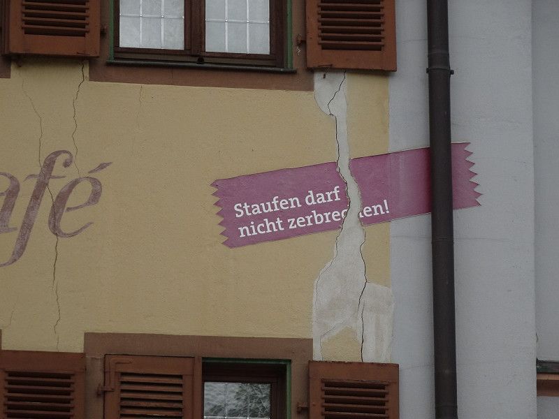
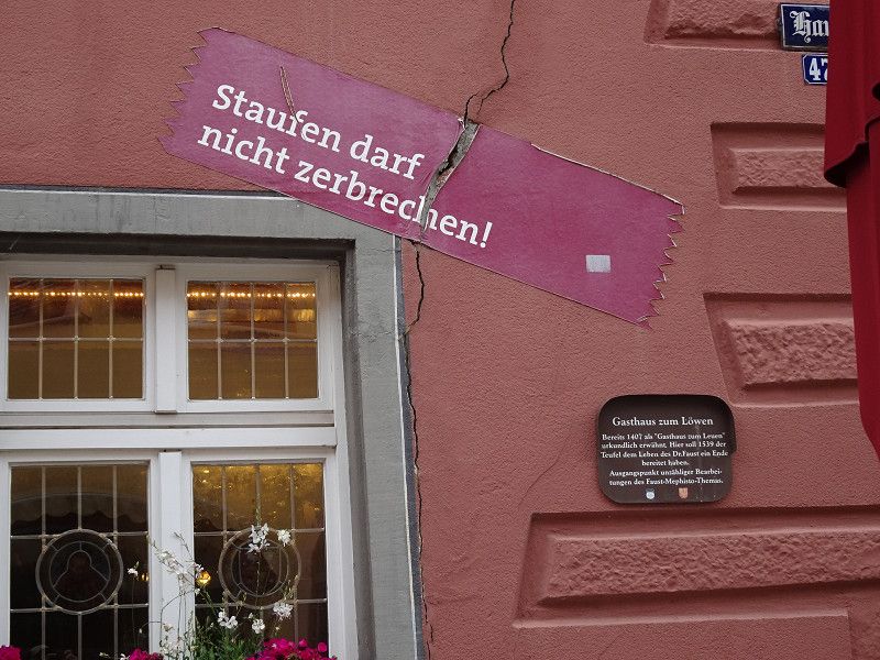
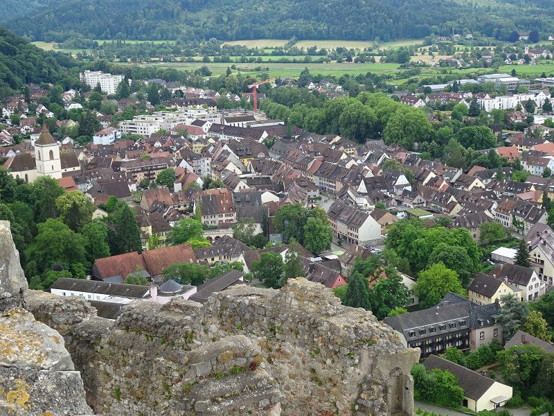
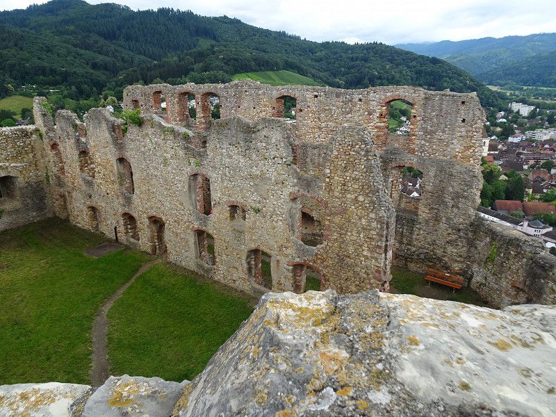
Staufen im Breisgau, Deutschland
Historic old town and unfortunately a town built on gypsum, which rises and partially breaks after geothermal drilling.
There is a beautiful and short hike to Staufen Castle, which is rewarded with a beautiful view.
79219 Staufen im Breisgau, Deutschland
47° 52' 56.6" N 7° 43' 43.2" E
47.8823873 7.7286645
• Head toward Wettelbrunner Straße on Neumagenstraße. Go for 47 m.
• Continue on Wettelbrunner Straße toward Schönau/Münstertal. Go for 121 m.
• Continue on Münstertäler Straße. Go for 1.1 km.
• Continue on Im Steiner. Go for 55 m.
• Turn left onto Münstertäler Straße (L123) toward Schönau/Münstertal. Go for 2.7 km.
• Turn left onto Dietzelbachstraße. Go for 181 m.
• Arrive at Dietzelbachstraße. Your destination is on the left.
☍
4,2 km
( 5 min.)
Camping Münstertal
Dietzelbachstraße 6, 79244, Münstertal, Germany
47° 51' 35" N 7° 45' 48" E
47.8597200 7.7633300
• Head south on Dietzelbachstraße. Go for 181 m.
• Turn left onto Hof (L123). Go for 1.6 km.
• Enter the roundabout. Go for 75 m.
• Arrive at your destination on the left.
☍
1,9 km
( 3 min.)
Day
Münstertal/Schwarzwald, Deutschland
Beekeeping Museum
Visitor Silver Mine
Typical Black Forest region
79244 Münstertal/Schwarzwald, Deutschland
47° 51' 16.2" N 7° 47' 3.2" E
47.8545108 7.7842144
• Follow the roundabout. Go for 76 m.
• Take the 3rd exit from roundabout onto Wasen (L123). Go for 1.9 km.
• Turn right toward Sankt Trudpert. Go for 11 m.
• Continue on Sankt Trudpert. Go for 157 m.
• Arrive at Sankt Trudpert.
☍
2,1 km
( 3 min.)
St. Trudpert, Münstertal/Schwarzwald, Deutschland
The monastery of St. Trudbert, newly built in 1709, stands beautifully above the village.
The church can be visited daily, but unfortunately the monastery cannot.
St. Trudpert, 79244 Münstertal/Schwarzwald, Deutschland
47° 51' 49.9" N 7° 48' 6.8" E
47.8638645 7.8018986
• Head north on Sankt Trudpert. Go for 168 m.
• Turn left onto L123. Go for 1.9 km.
• Take the 1st exit from roundabout onto Wasen (L130). Go for 1.7 km.
• Turn right onto Dietzelbachstraße. Go for 181 m.
• Arrive at Dietzelbachstraße. Your destination is on the left.
☍
3,9 km
( 6 min.)
Camping Münstertal
Dietzelbachstraße 6, 79244, Münstertal, Germany
47° 51' 35" N 7° 45' 48" E
47.8597200 7.7633300
• Head south on Dietzelbachstraße. Go for 181 m.
• Turn left onto Hof (L123). Go for 1.6 km.
• Take the 2nd exit from roundabout onto Wasen (L123). Go for 14.2 km.
• Turn right onto K6341. Go for 5.3 km.
• Turn right onto Multen (K6341). Go for 487 m.
• Turn left onto Multen. Go for 23 m.
• Arrive at Multen.
☍
21,9 km
( 26 min.)
Day
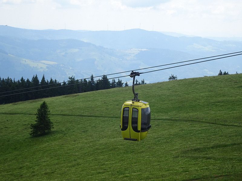
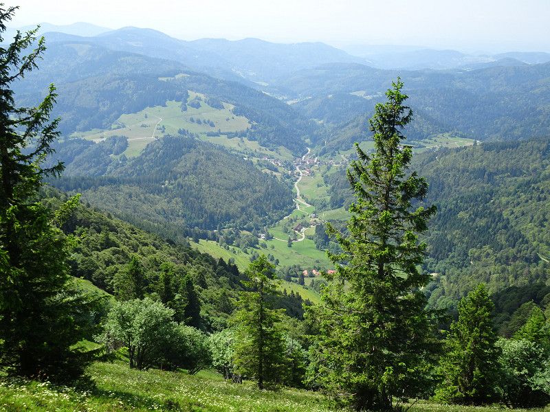
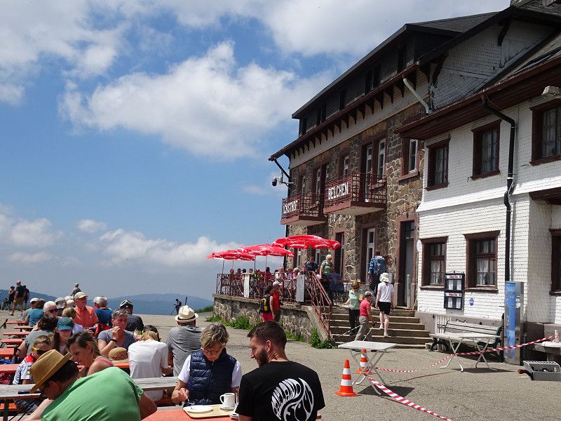
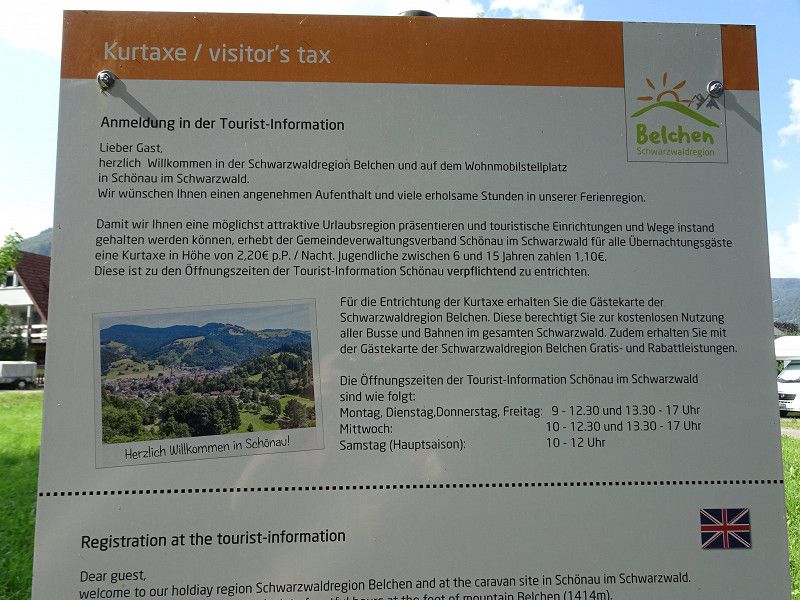
Belchengipfel, Münstertal/Schwarzwald, Deutschland
The hiking summit is accessible via a cable car. However, if you prefer, you should make your way to the summit on foot. From the mountain station, it is a short walk up to the viewing summit.
The mountain forms a triangle with Belchenfluh in Switzerland and Belchen in Alsace (Grand Ballon). The Celts already knew this!
Unnamed Road,79244, 79244 Münstertal/Schwarzwald, Deutschland
47° 49' 21" N 7° 50' 4.9" E
47.8224989 7.8346855
• Head west on Multen.
• Turn left onto Multen. Go for 129 m.
• Continue on Multen (K6341). Go for 378 m.
• Turn right onto Untermulten (L142). Go for 6.9 km.
• Turn right onto B317. Go for 1.8 km.
• Turn left onto Buchenbrandstraße. Go for 97 m.
• Turn right onto Bahnhofstraße. Go for 50 m.
• Turn left onto Wiesenstraße. Go for 152 m.
• Arrive at Wiesenstraße.
☍
9,5 km
( 12 min.)
Stellplatz Wiesenstrasse Schönau im Schwarzwald
Nice parking space with supply and disposal facilities. It is also located on the Wiese river and close to the Edeka and the town center with good shopping opportunities.
We had been briefly at the Schönau campsite before, but the chaos in front of the reception made us flee here. We were very happy at this campsite.
Wiesenstraße 18, Schönau im Schwarzwald, Landkreis Lörrach, Baden-Württemberg, Deutschland
47° 47' 0.1" N 7° 53' 43.7" E
47.7833603 7.8954807
• Head toward Gartenstraße on Wiesenstraße. Go for 206 m.
• Turn right onto Bahnhofstraße. Go for 120 m.
• Turn left onto Talstraße (K6305). Go for 76 m.
• Turn right onto Friedrichstraße (B317). Go for 1.6 km.
• Turn right onto B317 toward Donaueschingen/Todtnau/Münstertal. Go for 2.4 km.
• Turn right onto Im Dürracker (L149) toward St. Blasien/Bernau/Todtmoos/Präg. Go for 3.4 km.
• Turn right onto Hochkopfstraße (L151). Go for 931 m.
• Arrive at Hochkopfstraße (L151). Your destination is on the right.
☍
8,8 km
( 9 min.)
Day
Präg, Todtnau
Präg has a nature reserve with a glacial cirque.
Hochkopfstraße, Todtnau, Landkreis Lörrach, Baden-Württemberg, Deutschland
47° 46' 44.4" N 7° 58' 2.3" E
47.7789914 7.9673054
• Head toward Seeweg on Hochkopfstraße (L151). Go for 931 m.
• Turn right onto Wachtstraße (L149). Go for 12.0 km.
• Continue on L146. Go for 1.2 km.
• Continue on L149. Go for 4.8 km.
• Turn left onto Todtmooser Straße. Go for 139 m.
• Turn right onto Fürstabt-Gerbert-Straße. Go for 232 m.
• Turn right. Go for 30 m.
• Arrive at your destination on the right.
☍
19,3 km
( 19 min.)
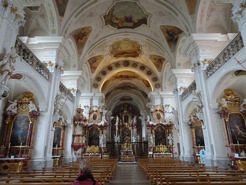
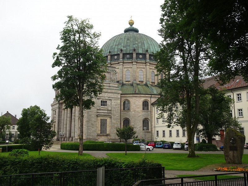
St. Blasien, Fürstabt-Gerbert-Straße, Sankt Blasien, Deutschland
The cathedral from 1783 is overwhelming. But it's like a slap in the face after visiting the previous monasteries and churches. This one was a real eye-opener. We left after 5 minutes.
Fürstabt-Gerbert-Straße 16, 79837 St. Blasien, Deutschland
47° 45' 36.1" N 8° 7' 49.2" E
47.7600163 8.1303220
• Head toward Fürstabt-Gerbert-Straße. Go for 30 m.
• Turn left onto Fürstabt-Gerbert-Straße. Go for 232 m.
• Turn left onto Todtmooser Straße. Go for 139 m.
• Turn left onto Umgehungsstraße (L149). Go for 1.5 km.
• Take the 2nd exit from roundabout onto L149. Go for 2.4 km.
• Take the 1st exit from roundabout onto Höchenschwander Straße (B500). Go for 19.4 km.
• Continue on Sankt-Blasier-Straße (B500). Go for 268 m.
• Turn right onto Eisenbahnstraße (B34) toward Schaffhausen/Tiengen/Schweiz. Go for 2.5 km.
• Turn right toward Koblenz. Go for 94 m.
• Continue on Rheinbrückenstraße. Go for 158 m.
• Continue on Rheinbrückerstrasse. Go for 61 m.
• Turn right onto Zollplatz. Go for 135 m.
• Continue on Bahnhofstrasse (7). Go for 69 m.
• Take the 3rd exit from roundabout onto Bahnhofstrasse (7) toward Schaffhausen/Winterthur/Bad Zurzach/Waldshut. Go for 5.4 km.
• Pass 3 roundabouts and continue on Hauptstrasse (7). Go for 17.0 km.
• Take ramp toward Glattfelden/Dielsdorf. Go for 210 m.
• Turn left onto Aarütistrasse (7). Go for 522 m.
• Turn right onto Kiesstrasse. Go for 5.1 km.
• Turn left toward Stadlerstrasse. Go for 85 m.
• Continue on Stadlerstrasse. Go for 1.8 km.
• Continue on Bülacherstrasse. Go for 101 m.
• Continue on Hochfelderstrasse. Go for 1.4 km.
• Turn right onto Badenerstrasse. Go for 1.1 km.
• Take the 3rd exit from roundabout onto A51 toward Zürich/Flughafen. Go for 11.7 km.
• Continue on Dreieck Zürich-Nord toward St. Gallen/Schaffhausen/Zürich-City. Go for 34 m.
• Take the exit onto A1/A4. Go for 1.3 km.
• Take the exit toward Zürich-City onto A1L. Go for 4.5 km.
• Turn left onto Wasserwerkstrasse. Go for 535 m.
• Continue on Stampfenbachstrasse. Go for 187 m.
• Turn right onto Stampfenbachplatz. Go for 173 m.
• Continue on Walcheplatz. Go for 47 m.
• Continue on Walchebrücke. Go for 90 m.
• Turn left onto Bahnhofquai. Go for 70 m.
• Keep right onto Bahnhofquai. Go for 110 m.
• Continue on Bahnhofplatz. Go for 156 m.
• Make a U-Turn onto Bahnhofplatz. Go for 251 m.
• Arrive at Bahnhofplatz.
☍
78,9 km
(1 hrs. 17 min.)
Zürich, Schweiz
47° 22' 36.8" N 8° 32' 30.1" E
47.3768866 8.5416940