Unfortunately, we don't support your browser (Internet Explorer) anymore, some functionalities could not work. Click here to get information on how to upgrade your browser.
Public
RV Tour Ireland from North to South
Waypoints to copy and adapt for a motorhome tour of Ireland from north to south - inland.
This description was automatically translated from German using Google Translate and may not be completely accurate.
Show in original language (German)

freeontour
Route info
1018 Kilometres
1 Day
22 Waypoints
Vehicle info
Add own vehicle
Copy route and test with own vehicle
Travelogue
Day 1
Einen ausführlichen Reisebericht zur Route gibt es im Freeontour-Magazin unter
Show in list
https://www.freeontour.com/de/magazin/reiseinspiration-irland-im-norden
Einen ausführlichen Reisebericht zur Route gibt es im Freeontour-Magazin unter
https://www.freeontour.com/de/magazin/reiseinspiration-irland-im-norden
Malin Head, County Donegal, Irland
Ardmalin, Malin Head, Co. Donegal, Irland
Show in list
Show on map
Malin Head, County Donegal, Irland
Ardmalin, Malin Head, Co. Donegal, Irland
Rathmullan, County Donegal, Irland
Aghavannan Near, Rathmullan, Co. Donegal, Irland
Show in list
Show on map
Rathmullan, County Donegal, Irland
Aghavannan Near, Rathmullan, Co. Donegal, Irland
Ballymastocker Heights, Irland
59WH+WHP Ballymastocker Heights, County Donegal, Irland
Show in list
Show on map
Ballymastocker Heights, Irland
59WH+WHP Ballymastocker Heights, County Donegal, Irland
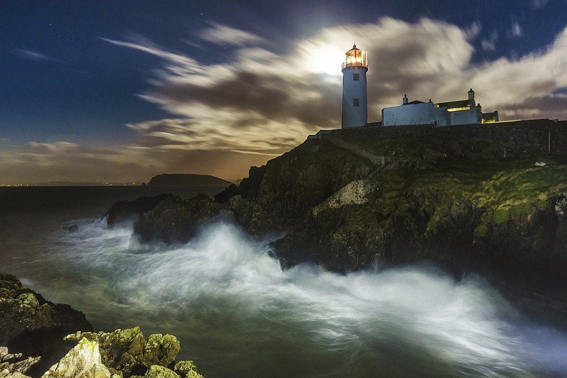
Fanad Head Leuchtturm, Irland
Arryheernabin, Co. Donegal, Irland
Glenveagh, County Donegal, Irland
Gartan Mountain, Glenveagh, Co. Donegal, Irland
Show in list
Show on map
Glenveagh, County Donegal, Irland
Gartan Mountain, Glenveagh, Co. Donegal, Irland
Killybegs, County Donegal, Irland
Killybegs, Co. Donegal, Irland
Enniskillen, Vereinigtes Königreich
Enniskillen BT74, Vereinigtes Königreich
Show in list
Show on map
Enniskillen, Vereinigtes Königreich
Enniskillen BT74, Vereinigtes Königreich
Marble Arch Caves, Vereinigtes Königreich
43 Marlbank Rd, Enniskillen BT92 1EW, Vereinigtes Königreich
Show in list
Show on map
Marble Arch Caves, Vereinigtes Königreich
43 Marlbank Rd, Enniskillen BT92 1EW, Vereinigtes Königreich
Athlone, County Westmeath, Irland
Athlone, Co. Westmeath, Irland
Clonmacnoise, County Offaly, Irland
Clonmacnoise, Co. Offaly, Irland
Kilbeggan, County Westmeath, Irland
Aghamore, Kilbeggan, Co. Westmeath, Irland
Show in list
Show on map
Kilbeggan, County Westmeath, Irland
Aghamore, Kilbeggan, Co. Westmeath, Irland
Tullamore, County Offaly, Irland
Tullamore, Co. Offaly, Irland
Birr, County Offaly, Irland
Townparks, Birr, Co. Offaly, Irland
Rock of Cashel, Irland
Rockside House, 1 Rock Ln, Moor, Cashel, Co. Tipperary, E25 NH42, Irland
Show in list
Show on map
Rock of Cashel, Irland
Rockside House, 1 Rock Ln, Moor, Cashel, Co. Tipperary, E25 NH42, Irland
Kinsale, County Cork, Irland
Kinsale, Co. Cork, Irland
Baltimore, County Cork, Irland
Ballylinchy, Baltimore, Co. Cork, Irland
Sherkin Island, County Cork, Irland
Harboursmouth, Sherkin Island, Co. Cork, Irland
Show in list
Show on map
Sherkin Island, County Cork, Irland
Harboursmouth, Sherkin Island, Co. Cork, Irland
Bantry, County Cork, Irland
Bantry, Co. Cork, Irland
Glengarriff, County Cork, Irland
Monteensudder, Glengarriff, Co. Cork, Irland
Show in list
Show on map
Glengarriff, County Cork, Irland
Monteensudder, Glengarriff, Co. Cork, Irland
Route
Show newest first
Day 1
Einen ausführlichen Reisebericht zur Route gibt es im Freeontour-Magazin unter
View travel report
Malin Head, County Donegal, Irland
- 55.382 -7.3734
- 55° 22' 55.2" N 7° 22' 24.2" W
Ardmalin, Malin Head, Co. Donegal, Irland
Show on map
104,1 km
1 hrs. 27 min.
Rathmullan, County Donegal, Irland
- 55.0971 -7.5363
- 55° 5' 49.5" N 7° 32' 10.7" W
Aghavannan Near, Rathmullan, Co. Donegal, Irland
Show on map
15,9 km
16 min.
Ballymastocker Heights, Irland
- 55.1973 -7.621
- 55° 11' 50.4" N 7° 37' 15.8" W
59WH+WHP Ballymastocker Heights, County Donegal, Irland
Show on map
21,9 km
22 min.
Fanad Head Leuchtturm, Irland
- 55.2756 -7.6343
- 55° 16' 32.2" N 7° 38' 3.3" W
Arryheernabin, Co. Donegal, Irland
Show on map
46,3 km
43 min.
Glenveagh, County Donegal, Irland
- 55.0525 -7.9336
- 55° 3' 8.8" N 7° 56' 1" W
Gartan Mountain, Glenveagh, Co. Donegal, Irland
Show on map
80,6 km
1 hrs. 6 min.
Killybegs, County Donegal, Irland
- 54.6348 -8.4547
- 54° 38' 5.1" N 8° 27' 17" W
Killybegs, Co. Donegal, Irland
Show on map
88,3 km
1 hrs. 7 min.
Enniskillen, Vereinigtes Königreich
- 54.3438 -7.6315
- 54° 20' 37.8" N 7° 37' 53.5" W
Enniskillen BT74, Vereinigtes Königreich
Show on map
20,1 km
19 min.
Marble Arch Caves, Vereinigtes Königreich
- 54.2585 -7.8131
- 54° 15' 30.7" N 7° 48' 47.3" W
43 Marlbank Rd, Enniskillen BT92 1EW, Vereinigtes Königreich
Show on map
122,7 km
1 hrs. 44 min.
Athlone, County Westmeath, Irland
- 53.4239 -7.9407
- 53° 25' 26.2" N 7° 56' 26.5" W
Athlone, Co. Westmeath, Irland
Show on map
28,2 km
27 min.
Clonmacnoise, County Offaly, Irland
- 53.3264 -7.9843
- 53° 19' 35.1" N 7° 59' 3.6" W
Clonmacnoise, Co. Offaly, Irland
Show on map
38,6 km
33 min.
Kilbeggan, County Westmeath, Irland
- 53.3685 -7.4995
- 53° 22' 6.4" N 7° 29' 58.1" W
Aghamore, Kilbeggan, Co. Westmeath, Irland
Show on map
12,8 km
14 min.
Tullamore, County Offaly, Irland
- 53.2755 -7.4934
- 53° 16' 31.9" N 7° 29' 36.2" W
Tullamore, Co. Offaly, Irland
Show on map
36,5 km
30 min.
Birr, County Offaly, Irland
- 53.098 -7.9097
- 53° 5' 52.8" N 7° 54' 34.9" W
Townparks, Birr, Co. Offaly, Irland
Show on map
77,9 km
1 hrs. 12 min.
Kilkenny, Irland
- 52.6541 -7.2448
- 52° 39' 14.9" N 7° 14' 41.2" W
Show on map
63,0 km
53 min.
Rock of Cashel, Irland
- 52.5199 -7.8891
- 52° 31' 11.8" N 7° 53' 20.8" W
Rockside House, 1 Rock Ln, Moor, Cashel, Co. Tipperary, E25 NH42, Irland
Show on map
96,1 km
1 hrs. 8 min.
Cork, Irland
- 51.8985 -8.4756
- 51° 53' 54.7" N 8° 28' 32.2" W
Show on map
27,1 km
31 min.
Kinsale, County Cork, Irland
- 51.7059 -8.5222
- 51° 42' 21.2" N 8° 31' 20" W
Kinsale, Co. Cork, Irland
Show on map
78,8 km
1 hrs. 26 min.
Baltimore, County Cork, Irland
- 51.4843 -9.3661
- 51° 29' 3.6" N 9° 21' 58" W
Ballylinchy, Baltimore, Co. Cork, Irland
Show on map
40,8 km
42 min.
Sherkin Island, County Cork, Irland
- 51.4787 -9.4023
- 51° 28' 43.3" N 9° 24' 8.3" W
Harboursmouth, Sherkin Island, Co. Cork, Irland
Show on map
Bantry, County Cork, Irland
- 51.6801 -9.4526
- 51° 40' 48.3" N 9° 27' 9.3" W
Bantry, Co. Cork, Irland
Show on map
17,7 km
19 min.
Glengarriff, County Cork, Irland
- 51.75 -9.5522
- 51° 45' 0.1" N 9° 33' 8" W
Monteensudder, Glengarriff, Co. Cork, Irland
Show on map
Travelogue
Day 1
Einen ausführlichen Reisebericht zur Route gibt es im Freeontour-Magazin unter
Show in list
https://www.freeontour.com/de/magazin/reiseinspiration-irland-im-norden
Einen ausführlichen Reisebericht zur Route gibt es im Freeontour-Magazin unter
https://www.freeontour.com/de/magazin/reiseinspiration-irland-im-norden
Malin Head, County Donegal, Irland
Ardmalin, Malin Head, Co. Donegal, Irland
Show in list
Show on map
Malin Head, County Donegal, Irland
Ardmalin, Malin Head, Co. Donegal, Irland
Rathmullan, County Donegal, Irland
Aghavannan Near, Rathmullan, Co. Donegal, Irland
Show in list
Show on map
Rathmullan, County Donegal, Irland
Aghavannan Near, Rathmullan, Co. Donegal, Irland
Ballymastocker Heights, Irland
59WH+WHP Ballymastocker Heights, County Donegal, Irland
Show in list
Show on map
Ballymastocker Heights, Irland
59WH+WHP Ballymastocker Heights, County Donegal, Irland
Fanad Head Leuchtturm, Irland
Arryheernabin, Co. Donegal, Irland
Glenveagh, County Donegal, Irland
Gartan Mountain, Glenveagh, Co. Donegal, Irland
Show in list
Show on map
Glenveagh, County Donegal, Irland
Gartan Mountain, Glenveagh, Co. Donegal, Irland
Killybegs, County Donegal, Irland
Killybegs, Co. Donegal, Irland
Enniskillen, Vereinigtes Königreich
Enniskillen BT74, Vereinigtes Königreich
Show in list
Show on map
Enniskillen, Vereinigtes Königreich
Enniskillen BT74, Vereinigtes Königreich
Marble Arch Caves, Vereinigtes Königreich
43 Marlbank Rd, Enniskillen BT92 1EW, Vereinigtes Königreich
Show in list
Show on map
Marble Arch Caves, Vereinigtes Königreich
43 Marlbank Rd, Enniskillen BT92 1EW, Vereinigtes Königreich
Athlone, County Westmeath, Irland
Athlone, Co. Westmeath, Irland
Clonmacnoise, County Offaly, Irland
Clonmacnoise, Co. Offaly, Irland
Kilbeggan, County Westmeath, Irland
Aghamore, Kilbeggan, Co. Westmeath, Irland
Show in list
Show on map
Kilbeggan, County Westmeath, Irland
Aghamore, Kilbeggan, Co. Westmeath, Irland
Tullamore, County Offaly, Irland
Tullamore, Co. Offaly, Irland
Birr, County Offaly, Irland
Townparks, Birr, Co. Offaly, Irland
Rock of Cashel, Irland
Rockside House, 1 Rock Ln, Moor, Cashel, Co. Tipperary, E25 NH42, Irland
Show in list
Show on map
Rock of Cashel, Irland
Rockside House, 1 Rock Ln, Moor, Cashel, Co. Tipperary, E25 NH42, Irland
Kinsale, County Cork, Irland
Kinsale, Co. Cork, Irland
Baltimore, County Cork, Irland
Ballylinchy, Baltimore, Co. Cork, Irland
Sherkin Island, County Cork, Irland
Harboursmouth, Sherkin Island, Co. Cork, Irland
Show in list
Show on map
Sherkin Island, County Cork, Irland
Harboursmouth, Sherkin Island, Co. Cork, Irland
Bantry, County Cork, Irland
Bantry, Co. Cork, Irland
Glengarriff, County Cork, Irland
Monteensudder, Glengarriff, Co. Cork, Irland
Show in list
Show on map
Glengarriff, County Cork, Irland
Monteensudder, Glengarriff, Co. Cork, Irland
Comments (0)
Comments from Freeontour users