6 days of pleasure trip with the motorhome through Spain - our suggested route for a motorhome tour in autumn along the Rías Baixas wine route.
Day
Santiago de Compostela, Spanien
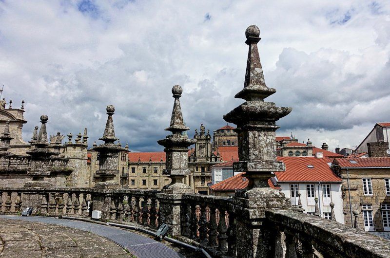
Obviously, if you are on your way to Galicia, you cannot avoid a city tour of Santiago de Compostela. After all, it is not only the capital of Galicia, but with its historical center is also a UNESCO World Heritage Site. In addition to the famous cathedral, which is the destination of thousands of pilgrims on the Way of St. James every year, there are many other palaces, churches, alleys and squares that should be visited.
Santiago de Compostela, Provinz A Coruña, Spanien
42° 52' 41.6" N 8° 32' 41.4" W
42.8782132 -8.5448445
• Head toward Travesa do Franco on Rúa do Vilar. Go for 189 m.
• Continue on Praza das Praterías. Go for 25 m.
• Turn right onto Rúa Conga. Go for 113 m.
• Turn left onto Rúa Conga. Go for 30 m.
• Turn left onto Rúa San Paio de Antealtares. Go for 136 m.
• Turn right onto Vía Sacra. Go for 29 m.
• Turn left onto Rúa da Acibechería. Go for 72 m.
• Continue on Praza da Inmaculada. Go for 44 m.
• Turn slightly left onto Travesa das Dúas Portas. Go for 109 m.
• Turn right onto Rúa de San Francisco. Go for 141 m.
• Turn right onto Rúa Costa de San Francisco. Go for 45 m.
• Continue on Avenida de Xoán XXIII. Go for 1.1 km.
• Continue on Rúa de San Caetano. Go for 300 m.
• Turn right onto Avenida de Rodríguez de Viguri (N-634). Go for 117 m.
• Turn left onto Rúa das Cancelas. Go for 29 m.
• Turn right onto Rúa das Cancelas. Go for 588 m.
• Take the 2nd exit from roundabout onto Rúa do Vintecinco de Xullo. Go for 305 m.
• Arrive at Rúa do Vintecinco de Xullo. Your destination is on the left.
☍
3,4 km
( 10 min.)
Camping las Cancelas
Rua Do 25 De Xullo 35, 15704, Santiago de Compostela, Spanien
42° 53' 21.1" N 8° 31' 27.1" W
42.8892000 -8.5242000
• Head southeast on Rúa do Vintecinco de Xullo. Go for 183 m.
• Turn left onto Rúa da Pena María. Go for 10 m.
• Turn right onto Rúa Madre Teresa Calcuta. Go for 33 m.
• Turn left onto Rúa Pilar Miró. Go for 137 m.
• Turn right onto Rúa de Raimundo García Rodríguez. Go for 88 m.
• Turn left onto Rúa de San Lázaro (N-634). Go for 333 m.
• Pass 2 roundabouts and continue on Rúa de San Lázaro (N-634). Go for 548 m.
• Take the 3rd exit from roundabout toward E-1/A-9/A Coruña/Pontevedra/SC-20/N-550/Aeroporto Lavacolla/A-54/Lugo/Oviedo. Go for 412 m.
• Take the 1st exit from roundabout onto AP-9 (Autoestrada do Atlántico) toward Pontevedra/AP-53/N-525/Ourense. Go for 7.7 km.
• Take exit 75 toward Noia/Milladoiro/Santiago/SC-20/Hospital onto AG-56. Go for 7.7 km.
• Take exit 7 toward Bertamiráns Norte/Negreira/Ames. Go for 604 m.
• Take the 2nd exit from roundabout onto Caroubáns (AC-544). Go for 6.1 km.
• Pass 4 roundabouts and continue on A Pereiriña (AC-546). Go for 18.5 km.
• Take the 2nd exit from roundabout onto AC-441. Go for 21.1 km.
• Turn left onto Berdoias (AC-552). Go for 14.2 km.
• Take the 2nd exit from roundabout onto VG-1.4. Go for 4.9 km.
• Take the 1st exit from roundabout onto Rúa da Coruña (AC-445). Go for 1.2 km.
• Continue on AC-445. Go for 196 m.
• Continue on Sardiñeiro de Abaixo (AC-445). Go for 50 m.
• Continue on AC-445. Go for 17 m.
• Continue on Sardiñeiro de Abaixo (AC-445). Go for 211 m.
• Continue on AC-445. Go for 2.0 km.
• Continue on Calcova (AC-445). Go for 222 m.
• Continue on AC-445. Go for 120 m.
• Continue on Calcova (AC-445). Go for 308 m.
• Continue on AC-445. Go for 53 m.
• Continue on Calcova (AC-445). Go for 38 m.
• Continue on As Escaselas (AC-445). Go for 830 m.
• Continue on Lugar Anchoa (AC-445). Go for 780 m.
• Continue on AC-445. Go for 743 m.
• Turn right onto Rúa Cabo Fisterra (AC-445). Go for 155 m.
• Continue on Rúa Alcalde Fernández (AC-445). Go for 385 m.
• Turn right onto Rúa Potina. Go for 59 m.
• Turn right onto Rúa Potina. Go for 122 m.
• Continue on Barrio Insua. Go for 223 m.
• Turn right onto Camiño Insua. Go for 184 m.
• Continue on A Insua. Go for 107 m.
• Arrive at A Insua. Your destination is on the right.
☍
90,5 km
(1 hrs. 14 min.)
Day
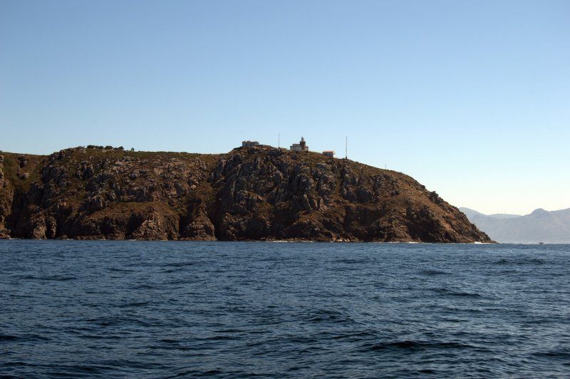
Kap Finisterre, Spanien
The cape is a rising cliff that rises from the dreaded islets O Petonciño and A Centola up to the hill O Facho (242 m). In ancient times, the Ara Solis is said to have been located here, i.e. the place where rituals in honor of the sun were celebrated. Various sources see a direct parallelism between the sun sinking into the sea and the host and the sacred chalice in the coat of arms of Galicia.
To get to the lighthouse, there is a small road that leads directly from the village of Fisterra. On the way you can enjoy breathtaking views of the coast and the Ría de Corcubión. Close to the lighthouse, you should also visit the cemetery - an innovative work by the architect César Portela, which with its cubic shapes is far removed from the classic concept of a cemetery.
The further ascent to Monte Facho is also worthwhile: At the top you come across the ruins of the San Guillermo hermitage. Particularly interesting is the "Cama de San Guillermo", a pit cut into the rock the size of a human body. Legend has it that the women of this region came to this place to ask the saint for fertility.
Kap Finisterre, Provinz A Coruña, Spanien
42° 54' 10.7" N 9° 16' 12.9" W
42.9029599 -9.2702429
• Head toward Camiño Insua on A Insua. Go for 107 m.
• Continue on Camiño Insua. Go for 121 m.
• Turn slightly right onto Camiño Insua. Go for 63 m.
• Turn left onto Barrio Insua. Go for 72 m.
• Continue on Barrio Insua. Go for 151 m.
• Continue on Rúa Potina. Go for 122 m.
• Turn left onto Rúa Potina. Go for 59 m.
• Turn left onto Rúa Alcalde Fernández (AC-445). Go for 385 m.
• Continue on Rúa Cabo Fisterra (AC-445). Go for 155 m.
• Turn left onto AC-445. Go for 743 m.
• Continue on Lugar Anchoa (AC-445). Go for 780 m.
• Continue on As Escaselas (AC-445). Go for 830 m.
• Continue on Calcova (AC-445). Go for 38 m.
• Keep right onto AC-445. Go for 53 m.
• Continue on Calcova (AC-445). Go for 308 m.
• Continue on AC-445. Go for 120 m.
• Continue on Calcova (AC-445). Go for 222 m.
• Continue on AC-445. Go for 2.0 km.
• Continue on Sardiñeiro de Abaixo (AC-445). Go for 211 m.
• Continue on AC-445. Go for 17 m.
• Continue on Sardiñeiro de Abaixo (AC-445). Go for 50 m.
• Continue on AC-445. Go for 196 m.
• Continue on Rúa da Coruña (AC-445). Go for 1.2 km.
• Take the 2nd exit from roundabout onto VG-1.4. Go for 4.9 km.
• Take the 1st exit from roundabout onto Xallas (AC-552). Go for 625 m.
• Take the 2nd exit from roundabout onto O Vilar de Toba (AC-552). Go for 1.7 km.
• Turn left onto Avenida Fernando Blanco (AC-550). Go for 24.3 km.
• Turn right onto Rúa Iglesias. Go for 20 m.
• Turn right onto Rúa Iglesias. Go for 124 m.
• Continue on Barrio Carnota. Go for 102 m.
• Continue on Estrada Carnota. Go for 812 m.
• Continue on Pedramarrada. Go for 47 m.
• Arrive at Pedramarrada.
☍
40,6 km
( 44 min.)
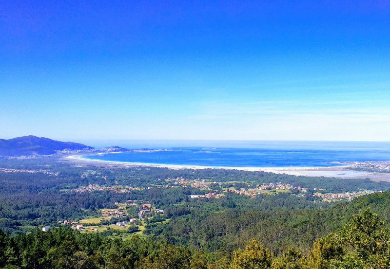
Praia de Carnota, Spanien
To relax and enjoy, we suggest a trip to Praia de Carnota beach - one of the largest beaches in Galicia. Seven kilometers long and half a kilometer wide plus the dunes that expand it, this beach forms a canal in the north through which the sea penetrates and forms a huge island-shaped sand area that is an active natural area.
Praia de Carnota, Provinz A Coruña, Spanien
42° 49' 52.8" N 9° 6' 21" W
42.8313354 -9.1058444
• Head toward Estrada Carnota on Pedramarrada. Go for 47 m.
• Continue on Estrada Carnota. Go for 812 m.
• Continue on Barrio Carnota. Go for 102 m.
• Turn right onto Barrio Carnota. Go for 36 m.
• Continue toward Barrio Carnota. Go for 18 m.
• Turn slightly left onto Barrio Carnota. Go for 58 m.
• Turn slightly right onto Barrio Carnota. Go for 184 m.
• Turn right onto Rúa Carrasqueira (AC-550). Go for 13.0 km.
• Turn right toward Campo de Cortes. Go for 34 m.
• Continue on Campo de Cortes. Go for 96 m.
• Arrive at Campo de Cortes. Your destination is on the right.
☍
14,4 km
( 16 min.)
Camping A' Vouga
Carretera Muros Finisterre km. 3, 15291, Louro, Spanien
42° 45' 38.2" N 9° 3' 42.5" W
42.7606000 -9.0618000
• Head southwest on Campo de Cortes. Go for 130 m.
• Turn right onto AC-550. Go for 1.4 km.
• Keep left onto AC-550. Go for 1.6 km.
• Arrive at Avenida Calvo Sotelo (AC-550). Your destination is on the left.
☍
3,1 km
( 3 min.)
Day
Muros, Spanien
Take a stroll through Muros town. The origins of the city go back to the Middle Ages, which the historical town center still tells about today. Here you can find e.g. B. Houses with coats of arms, streets with colonnades, churches and small squares where you can sit down comfortably with a coffee or another drink. At lunchtime, the small fish restaurants are definitely worth a visit!
Muros, A Coruña, Spanien
42° 46' 28.6" N 9° 3' 28.3" W
42.7746007 -9.0578552
• Head toward Rúa Ancha on Avenida Calvo Sotelo (AC-550). Go for 1.4 km.
• Take the 1st exit from Rúa Acea roundabout onto Rueiro a Acea (AC-550). Go for 18.3 km.
• Take the 2nd exit from roundabout onto AC-554. Go for 4.2 km.
• Continue on AC-550. Go for 1.3 km.
• Take the 2nd exit from roundabout onto Orro (AC-550) toward P.I. Augalevada/Noia Norte. Go for 263 m.
• Continue on AC-550. Go for 269 m.
• Continue on Estrada Orro (AC-550). Go for 544 m.
• Continue on AC-550. Go for 168 m.
• Continue on Rúa Vista Fermosa (AC-550). Go for 450 m.
• Take the 2nd exit from roundabout onto Rúa Vista Fermosa (AC-550). Go for 856 m.
• Continue on Rúa Carcasia (AC-550). Go for 273 m.
• Continue on Rúa Calvario (AC-550). Go for 145 m.
• Continue on Rúa Rosalía de Castro (AC-550). Go for 32 m.
• Take the 1st exit from roundabout onto Rúa Rosalía de Castro (AC-550). Go for 49 m.
• Turn right onto Rúa da Pedra Sartaña. Go for 208 m.
• Continue on Peirao do Marqués. Go for 294 m.
• Turn left onto Costa do Ferrador (AC-550). Go for 142 m.
• Turn left onto Rúa Rosalía de Castro (AC-550). Go for 11 m.
• Arrive at Rúa Rosalía de Castro (AC-550). Your destination is on the right.
☍
28,9 km
( 31 min.)
Noia, Spanien
Similar to Muros, Noia can look back on a long history, which is reflected in the old town. Today the small town is famous for its good fish cuisine and the enigmatic tombstones in one of the cemeteries: At the church of Santa María a Nova from the 14th century, 500 tombstones from the Middle Ages (12th century) can be seen in the cemetery, some of them in the church itself. They show the geometric shapes of the guilds of that time - a collection that cannot be found anywhere else in Spain.
Noia, Provinz A Coruña, Spanien
42° 47' 3.4" N 8° 53' 17.8" W
42.7842757 -8.8882891
• Head toward Rúa Galicia on Rúa Rosalía de Castro (AC-550). Go for 35 m.
• Turn left onto Rúa Besteiros. Go for 173 m.
• Turn left onto Peirao do Marqués. Go for 83 m.
• Continue on Rúa Malecón Gasset (AC-550). Go for 251 m.
• Take the 1st exit from roundabout onto Ponte Campo das Rodas (AC-550). Go for 229 m.
• Turn left onto Rúa Vizconde San Alberto Bergondo (DP-1105). Go for 1.4 km.
• Keep right onto A Ponte de San Francisco (DP-1105). Go for 12.7 km.
• Take the 2nd exit from roundabout. Go for 151 m.
• Continue on Bermo. Go for 458 m.
• Take the 2nd exit from roundabout toward Padrón. Go for 48 m.
• Take ramp onto AG-11. Go for 13.2 km.
• Take exit 11 toward Catoira/PO-548/Vilagarcía/Pontevedra/AP-9. Go for 317 m.
• Take the 1st exit from roundabout onto AC-553. Go for 1.4 km.
• Take the 2nd exit from roundabout onto EP-8001. Go for 1.9 km.
• Take the 1st exit from roundabout onto Avenida da Ponte (PO-548). Go for 1.2 km.
• Take the 2nd exit from roundabout onto PO-548. Go for 425 m.
• Take the 3rd exit from roundabout onto Rúa do Concello (PO-548). Go for 6.9 km.
• Take the 2nd exit from roundabout onto VG-4.7. Go for 7.6 km.
• Take the 6th exit from roundabout onto Santa Catalina (N-640). Go for 752 m.
• Continue on Ande (N-640). Go for 566 m.
• Continue on Rubiáns de Arriba (N-640). Go for 20 m.
• Continue on Ande (N-640). Go for 264 m.
• Turn right onto A Feira Nova. Go for 70 m.
• Turn left onto A Feira Nova. Go for 40 m.
• Continue on Estrada de Pazos. Go for 25 m.
• Turn right toward A Feira Nova. Go for 17 m.
• Turn right onto A Feira Nova. Go for 90 m.
• Arrive at A Feira Nova. Your destination is on the left.
☍
50,3 km
( 41 min.)
Pazo de Rubianes, Rúa Pazo, Vilagarcía de Arousa, Spanien
To end the day comfortably, we suggest a visit to the Pazo de Rubianes winery with its bodegas and gardens. Here you can also have your favorite wine bottled directly from the barrel ...
Rúa Pazo, 7, 36619 Vilagarcía de Arousa, Pontevedra, Spanien
42° 34' 41.2" N 8° 43' 58.9" W
42.5781212 -8.7330244
• Head southwest on A Feira Nova. Go for 90 m.
• Turn left toward Estrada de Pazos. Go for 17 m.
• Turn right onto Estrada de Pazos. Go for 232 m.
• Turn sharp left onto Avenida Rubians (N-640). Go for 76 m.
• Continue on A Feira Nova (N-640). Go for 61 m.
• Continue on Rubiáns de Arriba (N-640). Go for 165 m.
• Continue on Ande (N-640). Go for 264 m.
• Continue on Rubiáns de Arriba (N-640). Go for 20 m.
• Continue on Ande (N-640). Go for 566 m.
• Continue on Santa Catalina (N-640). Go for 571 m.
• Take the 2nd exit from roundabout onto N-640 toward Vilagarcía/Porto. Go for 4.0 km.
• Take ramp toward Cornazo/Santa Mariña/Cambados. Go for 409 m.
• Take the 2nd exit from roundabout onto VG-4.3 toward Cambados/Illa de Arousa/Vilanova. Go for 3.7 km.
• Take ramp toward Vilanova de Arousa/Illa de Arousa. Go for 372 m.
• Take the 1st exit from roundabout onto VG-4.3. Go for 1.4 km.
• Take the 2nd exit from roundabout. Go for 52 m.
• Continue on A Pantrigueira (PO-307). Go for 452 m.
• Continue on San Roque do Monte (PO-307). Go for 482 m.
• Continue on PO-307. Go for 132 m.
• Continue on San Roque do Monte (PO-307). Go for 181 m.
• Continue on O Terrón (PO-307). Go for 99 m.
• Continue on PO-307. Go for 23 m.
• Turn right toward O Terrón/PO-306. Go for 34 m.
• Take the 1st exit from roundabout. Go for 36 m.
• Continue on O Terrón (PO-306). Go for 37 m.
• Turn left toward O Terrón. Go for 104 m.
• Continue on O Terrón. Go for 55 m.
• Turn right onto O Terrón. Go for 89 m.
• Turn slightly left onto O Terrón. Go for 166 m.
• Arrive at O Terrón. Your destination is on the right.
☍
13,9 km
( 13 min.)
Camping Playa Paisaxe
Playa O Terrón 16, 36620, Vilanova de Arousa, Spanien
42° 33' 7.9" N 8° 49' 58.4" W
42.5522000 -8.8329000
• Head southwest on O Terrón. Go for 79 m.
• Turn left onto O Terrón. Go for 203 m.
• Continue on O Terrón. Go for 69 m.
• Continue toward O Terrón/PO-306. Go for 104 m.
• Turn right onto O Terrón (PO-306). Go for 69 m.
• Take the 2nd exit from roundabout onto PO-307. Go for 85 m.
• Continue on O Terrón (PO-307). Go for 99 m.
• Continue on San Roque do Monte (PO-307). Go for 181 m.
• Continue on PO-307. Go for 132 m.
• Continue on San Roque do Monte (PO-307). Go for 482 m.
• Continue on A Pantrigueira (PO-307). Go for 480 m.
• Take the 1st exit from roundabout onto Cardalda (PO-549). Go for 2.5 km.
• Take the 2nd exit from roundabout onto Avenida de Vilagarcía (PO-549). Go for 444 m.
• Take the 3rd exit from roundabout onto Avenida de Vilagarcía (PO-549). Go for 708 m.
• Turn right onto Avenida da Coruña. Go for 226 m.
• Take the 2nd exit from roundabout onto Rúa Pombal. Go for 190 m.
• Continue toward Rúa Ribeira de Fefiñans. Go for 24 m.
• Take the 2nd exit from roundabout onto Rúa Ribeira de Fefiñans. Go for 432 m.
• Continue toward Avenida de Galicia/PO-550. Go for 23 m.
• Take the 2nd exit from roundabout onto Avenida de Galicia (PO-550). Go for 65 m.
• Turn left onto Praza de Concello. Go for 39 m.
• Turn right onto Praza Ramón Cabanillas. Go for 19 m.
• Turn slightly right onto Praza Ramón Cabanillas. Go for 48 m.
• Continue on Rúa Infantas. Go for 70 m.
• Arrive at Rúa Infantas. Your destination is on the left.
☍
6,8 km
( 10 min.)
Day
Cambados, Spanien
Time to visit the wine town of Cambados. The city is located on the Arousa estuary and is the capital of the Albariño wine region. The old town is a listed building and is home to one of the most important groups of aristocratic country estates in Galicia.
If you really want to enjoy Cambados, you should roam the city on foot. Take a look at buildings like the ruins of Santa Mariña from the 16th century or the Plaza de Fefiñáns and next to it the estate of the Figueroa family and the church of San Bieito from the 16th century. Also worth seeing are the Montesacro and Bazán estates, which now house a Parador hotel, as well as the Palace of the Counts of Maceda, a medieval building that was renovated in the 17th century, and the palace of the Chariño-Sotomayor family. You will walk again and again through high vine trellises on which the Albariño and Espadeiro grapes ripen.
Also visit the wine museum!
Cambados, Provinz Pontevedra, Spanien
42° 30' 49.5" N 8° 48' 52.3" W
42.5137374 -8.8145173
• Head toward Rúa Nova on Rúa Infantas. Go for 62 m.
• Turn right onto Rúa Nova. Go for 89 m.
• Turn left onto Avenida de Galicia (PO-550). Go for 5.3 km.
• Pass 6 roundabouts and continue on A Touticeira (PO-550). Go for 7.7 km.
• Take the 1st exit from roundabout onto PO-316. Go for 829 m.
• Pass 3 roundabouts and continue on PO-316. Go for 1.9 km.
• Continue on Estonllo (PO-316). Go for 450 m.
• Continue on PO-316. Go for 1.2 km.
• Take the 2nd exit from roundabout onto Rúa Juan XXIII (PO-316). Go for 1.6 km.
• Enter the roundabout. Go for 25 m.
• Arrive at your destination on the left.
☍
19,3 km
( 22 min.)
O Grove, Spanien
The O Grove peninsula is located at the entrance to the Arousa estuary. The contrasting colors of the fishing boats make for an unforgettable sight. The population lives from coastal fishing as well as from mussel, oyster and scallop farming. That's why you shouldn't leave this place without having tried seafood in a local pub.
Enjoy the landscape on a long walk along the coast over the wonderful wooden walkways! they are not far from Camping Siglo.
O Grove, Provinz Pontevedra, Spanien
42° 29' 45.6" N 8° 51' 54.5" W
42.4959962 -8.8651418
• Follow the roundabout.
• Take the 1st exit from roundabout onto Rúa Pablo Iglesias. Go for 1.6 km.
• Take the 1st exit from roundabout onto PO-316. Go for 1.2 km.
• Continue on Estonllo (PO-316). Go for 450 m.
• Continue on PO-316. Go for 79 m.
• Take the 3rd exit from roundabout onto PO-316. Go for 864 m.
• Pass 2 roundabouts and continue on PO-316. Go for 1.8 km.
• Take the 1st exit from roundabout onto PO-308. Go for 457 m.
• Take the 2nd exit from roundabout onto VG-4.1. Go for 7.0 km.
• Continue on AG-41. Go for 18.7 km.
• Take the left exit toward Santiago onto AP-9 (Autoestrada do Atlántico). Go for 15.5 km.
• Take exit 104 toward Catoira/Ribeira/Valga/N-550. Go for 547 m.
• Turn left onto EP-8001. Go for 7.9 km.
• Take the 2nd exit from roundabout onto A Corredoira (EP-8001). Go for 1.8 km.
• Take the 2nd exit from roundabout onto O Regueiro (AC-553). Go for 1.5 km.
• Take the 3rd exit from roundabout onto AG-11 toward Bexo/Ribeira. Go for 29.5 km.
• Take the 2nd exit from roundabout onto A Soledá (DP-7301). Go for 337 m.
• Continue on Deán Pequeno (DP-7301). Go for 89 m.
• Continue on A Soledá (DP-7301). Go for 449 m.
• Continue on DP-7301. Go for 990 m.
• Continue on A Granxa-Carreira (DP-7301). Go for 148 m.
• Continue on DP-7301. Go for 61 m.
• Continue on A Granxa-Carreira (DP-7301). Go for 47 m.
• Continue on DP-7301. Go for 261 m.
• Continue on Frións (DP-7301). Go for 297 m.
• Continue on DP-7301. Go for 366 m.
• Continue on Frións (DP-7301). Go for 68 m.
• Continue on DP-7301. Go for 160 m.
• Continue on Frións (DP-7301). Go for 137 m.
• Continue on DP-7301. Go for 14 m.
• Continue on Frións (DP-7301). Go for 55 m.
• Take the 2nd exit from roundabout onto DP-7305. Go for 83 m.
• Continue on Frións (DP-7305). Go for 103 m.
• Continue on DP-7305. Go for 487 m.
• Turn right onto Rúa Capela (CP-7306). Go for 788 m.
• Continue on DP-7306. Go for 113 m.
• Continue on A Graña (DP-7306). Go for 328 m.
• Continue on DP-7306. Go for 113 m.
• Continue on A Graña (DP-7306). Go for 521 m.
• Continue on DP-7306. Go for 55 m.
• Continue on A Graña (DP-7306). Go for 213 m.
• Continue on DP-7306. Go for 17 m.
• Continue on A Graña (DP-7306). Go for 123 m.
• Turn right onto Camiño de Muzelle. Go for 406 m.
• Turn slightly right onto Pista a Ángel López Souto. Go for 1.1 km.
• Arrive at Pista a Ángel López Souto.
☍
96,9 km
(1 hrs. 5 min.)
Camping Siglo Xxi
Barrosa S/N, 36988, San Vicente do Mar, Spanien
42° 31' 31.1" N 9° 4' 0.8" W
42.5253000 -9.0669000
• Head toward Couso on Pista a Ángel López Souto. Go for 1.1 km.
• Turn slightly left onto Camiño de Muzelle. Go for 406 m.
• Turn left onto A Graña (DP-7306). Go for 123 m.
• Continue on DP-7306. Go for 17 m.
• Continue on A Graña (DP-7306). Go for 213 m.
• Continue on DP-7306. Go for 55 m.
• Continue on A Graña (DP-7306). Go for 521 m.
• Continue on DP-7306. Go for 113 m.
• Continue on A Graña (DP-7306). Go for 328 m.
• Continue on DP-7306. Go for 113 m.
• Continue on Rúa Capela (DP-7306). Go for 788 m.
• Turn left onto DP-7305. Go for 487 m.
• Continue on Frións (DP-7305). Go for 103 m.
• Continue on DP-7305. Go for 59 m.
• Take the 2nd exit from roundabout onto Frións (DP-7301). Go for 88 m.
• Continue on DP-7301. Go for 14 m.
• Continue on Frións (DP-7301). Go for 137 m.
• Continue on DP-7301. Go for 160 m.
• Continue on Frións (DP-7301). Go for 68 m.
• Continue on DP-7301. Go for 366 m.
• Continue on Frións (DP-7301). Go for 297 m.
• Continue on DP-7301. Go for 261 m.
• Continue on A Granxa-Carreira (DP-7301). Go for 47 m.
• Continue on DP-7301. Go for 61 m.
• Continue on A Granxa-Carreira (DP-7301). Go for 148 m.
• Continue on DP-7301. Go for 990 m.
• Continue on A Soledá (DP-7301). Go for 449 m.
• Continue on Deán Pequeno (DP-7301). Go for 89 m.
• Continue on A Soledá (DP-7301). Go for 246 m.
• Take the 2nd exit from roundabout onto AG-11. Go for 29.0 km.
• Take exit 11 toward Catoira/PO-548/Vilagarcía/Pontevedra/AP-9. Go for 317 m.
• Take the 1st exit from roundabout onto AC-553. Go for 1.4 km.
• Take the 2nd exit from roundabout onto EP-8001. Go for 1.9 km.
• Take the 2nd exit from roundabout onto Portocelo (EP-8001). Go for 7.9 km.
• Take ramp onto AP-9 (Autoestrada do Atlántico) toward Pontevedra. Go for 24.9 km.
• Take exit 129 toward Poio/C-550. Go for 490 m.
• Turn left onto O Vao (PO-531). Go for 180 m.
• Take the 1st exit from roundabout onto A Caeira (PO-531). Go for 430 m.
• Take the 3rd exit from roundabout onto Avenida de A Barca toward Marín/Pontevedra/Centro Cidade. Go for 93 m.
• Continue on Ponte da Barca. Go for 135 m.
• Continue on Paseo de Colón. Go for 70 m.
• Continue toward Paseo de Colón. Go for 28 m.
• Take the 1st exit from roundabout onto Paseo de Colón. Go for 260 m.
• Take the 2nd exit from roundabout onto Rúa San Roque. Go for 157 m.
• Turn left onto Rúa Ribeira dos Peiraos. Go for 179 m.
• Continue on Rúa da Pontenova. Go for 16 m.
• Continue on Rúa Los Palamios. Go for 321 m.
• Turn right onto Avenida Reina Victoria Eugenia. Go for 105 m.
• Continue on Rúa Augusto García Sánchez. Go for 41 m.
• Continue toward Avenida Augusto García Sánchez. Go for 21 m.
• Take the 2nd exit from Praza da Liberdade roundabout onto Avenida Augusto García Sánchez. Go for 121 m.
• Take the 2nd exit from Praza da Galícia roundabout onto Rúa Andrés Muruais. Go for 272 m.
• Turn left onto Rúa García Camba. Go for 85 m.
• Arrive at Rúa García Camba.
☍
76,2 km
( 55 min.)
Day
Pontevedra, Spanien
A day of strolling and gourmet food in Pontevedra. One of the most important and elegant old town centers in Galicia is located in this city with its long maritime and trading tradition. Alongside the Pontevedra estuary, the maze of streets and squares of the old city extends, where important civil and religious buildings stand.
Pontevedra, Provinz Pontevedra, Spanien
42° 25' 47.6" N 8° 38' 40.6" W
42.4298846 -8.6446202
• Head toward Rúa A Oliva on Rúa García Camba. Go for 46 m.
• Turn left onto Rúa A Oliva. Go for 68 m.
• Turn slightly left onto Praza de San Xosé. Go for 50 m.
• Continue on Rúa Augusto González Besada. Go for 122 m.
• Take the 1st exit from Praza da Galícia roundabout onto Avenida Augusto García Sánchez. Go for 132 m.
• Take the 2nd exit from Praza da Liberdade roundabout onto Avenida General Antero Rubín. Go for 105 m.
• Turn right onto Rúa Gagos de Mendoza. Go for 80 m.
• Continue on Rúa Rosalía de Castro. Go for 339 m.
• Take the 2nd exit from roundabout onto Rúa Manuel del Palacio. Go for 182 m.
• Take the 1st exit from roundabout onto Avenida de Marín. Go for 180 m.
• Continue toward Rúa San Roque. Go for 34 m.
• Take the 1st exit from roundabout onto Rúa San Roque. Go for 176 m.
• Take the 2nd exit from roundabout onto Rúa da Alameda. Go for 219 m.
• Continue on Rúa Echegaray. Go for 262 m.
• Take the 2nd exit from roundabout. Go for 19 m.
• Continue on Ponte da Barca. Go for 86 m.
• Continue on Ponte da Barca. Go for 135 m.
• Continue on Avenida de A Barca. Go for 27 m.
• Keep right onto Avenida de A Barca. Go for 52 m.
• Continue on Rúa Domingo Fontán (PO-531). Go for 343 m.
• Take the 3rd exit from roundabout onto PO-531 toward Cambados/VG-4.1/Sanxenxo/O Grove/Vilagarcía/Vigo/Santiago. Go for 166 m.
• Take ramp onto AP-9 (Autoestrada do Atlántico) toward Santiago. Go for 9.9 km.
• Take exit 119 toward Cambados/Sanxenxo/O Grove onto AG-41. Go for 19.3 km.
• Continue on VG-4.1 toward O Grove. Go for 1.7 km.
• Take ramp toward Portonovo/Adina. Go for 289 m.
• Turn left onto PO-320. Go for 111 m.
• Continue on A Xesteiriña (PO-320). Go for 478 m.
• Continue on Estrada Adina (PO-320). Go for 1.5 km.
• Keep right onto Rúa do Río. Go for 317 m.
• Turn right onto Carretera a la Lanzada (PO-308). Go for 630 m.
• Take the 1st exit from roundabout onto Carretera a la Lanzada (PO-308). Go for 1.2 km.
• Arrive at Paxariñas (PO-308). Your destination is on the left.
☍
38,3 km
( 30 min.)
Camping Paxariñas
Ctra. La Lanzada-portonovo S/N, 36970, Portonovo/sanxenxo, Spanien
42° 23' 33.7" N 8° 50' 39.5" W
42.3927000 -8.8443000
• Head south on Paxariñas (PO-308). Go for 1.2 km.
• Take the 2nd exit from roundabout onto Carretera a la Lanzada (PO-308). Go for 753 m.
• Turn right onto Rúa Espiñeiro. Go for 104 m.
• Turn sharp left onto Rúa Espiñeiro. Go for 63 m.
• Turn left onto Rúa Rafael Pico. Go for 43 m.
• Turn right onto Avenida de Galicia (PO-308). Go for 575 m.
• Take the 1st exit from roundabout onto Estrada Circunvalación (PO-308). Go for 1.0 km.
• Take the 3rd exit from roundabout onto Rúa Progreso (PO-308). Go for 541 m.
• Take the 2nd exit from roundabout onto Rúa Progreso (PO-308). Go for 714 m.
• Take the 3rd exit from roundabout onto Rúa Progreso (PO-308). Go for 2.4 km.
• Pass 4 roundabouts and continue on Avenida Covelo (PO-308). Go for 8.0 km.
• Arrive at Avenida da Costa (PO-308). Your destination is on the left.
☍
15,4 km
( 19 min.)
Day
Combarro, Spanien
Detour to the fishing village Combarro with its extraordinary Hórreos and other sights.
Combarro, Pontevedra, Spanien
42° 25' 50.1" N 8° 42' 24.3" W
42.4305807 -8.7067378
• Head toward Rúa Costa de Abaixo on Avenida da Costa (PO-308). Go for 2.3 km.
• Take the 1st exit from roundabout onto Avenida Seara (PO-308). Go for 2.6 km.
• Take the 1st exit from roundabout onto Rúa Fernando Besada-S Salvado (PO-309). Go for 124 m.
• Take the 3rd exit from roundabout toward Pontevedra Sur/A-9/Marín/Vigo/Ourense. Go for 84 m.
• Continue on Rúa Pateira. Go for 323 m.
• Continue on A Barca. Go for 70 m.
• Take ramp onto AP-9 (Autoestrada do Atlántico). Go for 24.5 km.
• Take exit 4V toward c/ G. Barbón/Porto/G. Barbón/I. Peral/Centro Cidade. Go for 627 m.
• Take the 2nd exit from roundabout onto Rúa Isaac Peral. Go for 162 m.
• Turn left onto Rúa Areal. Go for 644 m.
• Take the 2nd exit from roundabout onto Rúa Areal toward Centro Cidade. Go for 177 m.
• Take the 2nd exit from roundabout onto Rúa Areal. Go for 120 m.
• Turn right onto Rúa Concepción Arenal. Go for 149 m.
• Arrive at Rúa Concepción Arenal.
☍
31,9 km
( 24 min.)
Vigo, Spanien
Vigo is the southernmost city of the Rias Baixas. The old town center has been preserved from this original fishing village with a strong taste for seafaring, which contrasts with the modern facilities of the sports ports. Vigo is the perfect base from which to enjoy the villages of the Vigo Ria and the Cíes Islands, part of the Atlantic Islands National Park.
Stroll through Casco Vello and indulge in a few oysters in A Pedra. Or relax for a day on the beach in Samil. A boat tour to the Cíes Islands is also a good alternative to relaxing.
Vigo, Provinz Pontevedra, Spanien
42° 14' 26.2" N 8° 43' 14.6" W
42.2405989 -8.7207268
• Head north on Rúa Concepción Arenal. Go for 3 m.
• Turn left onto Rúa Montero Ríos. Go for 303 m.
• Turn right onto Rúa Cánovas del Castillo. Go for 260 m.
• Take the 2nd exit from roundabout onto Rúa Cánovas del Castillo. Go for 269 m.
• Continue on Avenida da Beiramar. Go for 138 m.
• Keep left onto Túnel de Beiramar toward Bouzas/Zona Franca/Praias. Go for 301 m.
• Continue on Avenida da Beiramar. Go for 18 m.
• Keep right onto Avenida da Beiramar. Go for 1.0 km.
• Take the 1st exit from roundabout onto Avenida Jacinto Benavente. Go for 125 m.
• Continue on Avenida da Beiramar. Go for 1.1 km.
• Continue on Rúa Eduardo Cabello. Go for 85 m.
• Keep right toward Rúa Eduardo Cabello. Go for 23 m.
• Take the 1st exit from roundabout onto Rúa Eduardo Cabello. Go for 284 m.
• Take the 3rd exit from roundabout. Go for 147 m.
• Continue on Rúa Eduardo Cabello. Go for 321 m.
• Take the 1st exit from roundabout onto VG-20 toward Praias/Nigrán/Baiona/E-1/Portugal/A-52/Madrid. Go for 1.0 km.
• Take ramp toward Centro Urbán. Go for 154 m.
• Take the 1st exit from roundabout onto Avenida Europa toward Avda. de Europa/Praias. Go for 370 m.
• Turn right onto Rúa da Castaña. Go for 71 m.
• Turn slightly left onto Camiño do Freixeiro. Go for 123 m.
• Turn left onto Rúa do Pazo Solita. Go for 190 m.
• Turn left onto Camiño da Fonte. Go for 12 m.
• Arrive at Camiño da Fonte. Your destination is on the left.
☍
6,3 km
( 10 min.)
Camping Playa Samil
Avda. Samil 71, 36212, Vigo, Spanien
42° 12' 58.3" N 8° 45' 48.2" W
42.2162000 -8.7634000