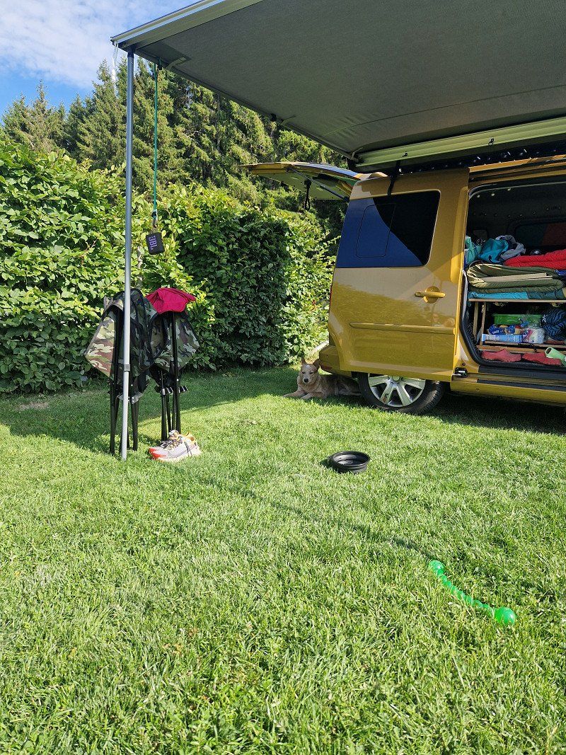
3 weeks Sweden, yeah :) Planned from August 21st to September 10th - Two people and three dogs in our DIY caddies.
www.engelundgumiboot.de
Wulfsen, Deutschland
53° 17' 59.7" N 10° 8' 39.2" E
53.2999208 10.1442217
• Head toward Bogenstraße on Kreisstraße (K7). Go for 738 m.
• Turn left onto Dorfstraße (K7). Go for 165 m.
• Turn right onto Pattensener Straße (K7). Go for 766 m.
• Continue on Im Grimm (K7). Go for 508 m.
• Turn left onto Pattenser Hauptstraße (L215). Go for 286 m.
• Turn right onto Blumenstraße (K8). Go for 3.7 km.
• Turn left and take ramp onto A39. Go for 9.6 km.
• Take exit 1 toward Lübeck/Berlin/Hamburg onto A1. Go for 12.8 km.
• Take exit 36 toward Lübeck/Berlin/Hamburg-Südost onto A1. Go for 69.1 km.
• Take exit 19 toward Sereetz/Bad Schwartau/Ratekau-Techau. Go for 352 m.
• Turn right onto L181 toward Techau/Ratekau/Bad Schwartau-Nord/Sereetz. Go for 1.6 km.
• Continue on Eutiner Straße (L309) toward Puttgarden/Kiel. Go for 12.6 km.
• Turn right and take ramp onto B432 toward Scharbeutz/A1. Go for 3.4 km.
• Take ramp onto A1 toward Puttgarden. Go for 47.2 km.
• Continue on B207. Go for 21.2 km.
• Keep left onto B207 toward Puttgarden. Go for 126 m.
• Turn left onto Fährhafenstraße (K49). Go for 592 m.
• Turn right onto Kabunskoppel. Go for 39 m.
• Arrive at Kabunskoppel. Your destination is on the left.
☍
184,9 km
(1 hrs. 55 min.)
Day
Puttgarden: Fähre nach Rödby
Fehmarn, Deutschland
54° 29' 47.8" N 11° 12' 44.4" E
54.4965982 11.2123327
• Head toward Bürgermeister-Landt-Straße on Kabunskoppel. Go for 39 m.
• Turn left onto Bürgermeister-Landt-Straße (K49). Go for 560 m.
• Turn left onto E47. Go for 868 m.
• Take the Puttgarden-Rødby Ferry. Stay on for 18.7 km.
• Head northeast. Go for 769 m.
• Take ramp toward Rødby/275/Rødbyhavn. Go for 111 m.
• Turn left onto Færgestationsvej toward Rødbyhavn/153/Rødby/275. Go for 262 m.
• Turn left onto Færgevej toward Rødby/153/275/Rødbyhavn. Go for 424 m.
• Continue on K. H. Kofoedsvej. Go for 92 m.
• Arrive at K. H. Kofoedsvej. Your destination is on the right.
☍
21,9 km
(1 hrs. 8 min.)
Rødbyhavn
Dänemark
54° 39' 45.9" N 11° 21' 23.8" E
54.6627430 11.3566210
• Head northwest on K. H. Kofoedsvej.
• Turn left onto K. H. Kofoedsvej. Go for 93 m.
• Turn right onto K. H. Kofoedsvej. Go for 151 m.
• Continue on Færgevej. Go for 424 m.
• Turn right onto Færgestationsvej toward København/E47/Puttgarden. Go for 196 m.
• Turn right and take ramp onto E47 (Sydmotorvejen) toward København. Go for 121 km.
• Continue on E20/E47 (Køge Vest). Go for 26.1 km.
• Continue on E20 (Avedøre) toward Malmø/Lufthavn/København C. Go for 27.7 km.
• Continue on E20 (Öresundsbron). Go for 12.6 km.
• Take the exit toward Malmö C/Svågertorp onto E6.1 (Trelleborgsvägen). Go for 2.4 km.
• Continue on Trelleborgsvägen toward Centrum/Sjukhus. Go for 2.7 km.
• Turn left onto Dalaplan toward Centrum/Sjukhus. Go for 119 m.
• Turn right onto Södra Förstadsgatan toward Sjukhus. Go for 655 m.
• Continue on Bergsgatan. Go for 909 m.
• Turn left onto Amiralsgatan toward Korpen. Go for 595 m.
• Continue on Studentgatan. Go for 96 m.
• Continue on Djäknegatan. Go for 103 m.
• Turn left onto Baltzarsgatan. Go for 47 m.
• Arrive at Baltzarsgatan. Your destination is on the right.
☍
195,8 km
(1 hrs. 56 min.)
Malmö
Schweden
55° 36' 17.9" N 13° 0' 13.8" E
55.6049810 13.0038220
• Head toward Djäknegatan on Baltzarsgatan. Go for 47 m.
• Turn left onto Djäknegatan. Go for 185 m.
• Continue on Rundelsgatan. Go for 26 m.
• Continue on Mäster Nilsgatan. Go for 123 m.
• Continue on Prostgatan. Go for 58 m.
• Turn right onto Norra Vallgatan. Go for 614 m.
• Take the 2nd exit from roundabout onto Hornsgatan toward E6/E20/E22/E11. Go for 201 m.
• Keep right onto Hornsgatan toward E22/E11. Go for 324 m.
• Turn left onto Hornsgatan toward E6/E20/E22/11. Go for 310 m.
• Turn slightly left onto Stockholmsvägen toward E4/E6/E22/11/Stockholm/Göteborg/Landskrona/Kalmar/Simrishamn/Lund. Go for 2.8 km.
• Continue on E22.10 (Stockholmsvägen). Go for 2.9 km.
• Take the exit toward Stockholm/E4 onto E6/E20. Go for 57.0 km.
• Continue on E6/E20 toward Göteborg/111/Höganäs/Helsingborg N. Go for 140 km.
• Take exit 55 toward Varberg N/41/Borås. Go for 440 m.
• Take the 1st exit from roundabout onto 41 toward Borås. Go for 10.3 km.
• Pass 8 roundabouts and continue on Söderleden (41). Go for 69.0 km.
• Keep right onto Arlagatan (42) toward 180/Centrum/Knalleland. Go for 1.6 km.
• Take the 1st exit from roundabout onto Norrby Långgata (42) toward Knalleland. Go for 484 m.
• Pass 6 roundabouts and continue on Stora vägen (183). Go for 27.3 km.
• Continue on Vesene Granebo. Go for 17 m.
• Continue on Vesene Björkhagen. Go for 2.3 km.
• Continue on Lida. Go for 984 m.
• Continue on Lida Hönestorp. Go for 2.7 km.
• Continue on Boråsvägen. Go for 906 m.
• Turn right onto Alingsåsvägen (182). Go for 328 m.
• Continue on Falköpingsvägen. Go for 943 m.
• Continue on Lystorp Lyckäng. Go for 479 m.
• Continue on Falköpingsvägen. Go for 2.3 km.
• Continue on Skölvene Marielund. Go for 1.0 km.
• Continue on Skölvene Hembygdsstuga. Go for 52 m.
• Continue on Skölvene. Go for 47 m.
• Continue on Skölvene Dalen. Go for 35 m.
• Continue on Skölvene. Go for 87 m.
• Continue on Skölvene Lövåsa. Go for 46 m.
• Continue on Skölvene Björkäng. Go for 40 m.
• Continue on Skölvene. Go for 237 m.
• Continue on Skölvene bygdegård. Go for 457 m.
• Turn right toward Skölvene Munkagården. Go for 259 m.
• Continue on Skölvene Munkagården. Go for 1.4 km.
• Continue on Vimle. Go for 458 m.
• Continue on Vimle Persgården. Go for 300 m.
• Continue on Vimle Skattegården. Go for 120 m.
• Continue on Vimle Bengtgården. Go for 46 m.
• Continue on Vimle Skattegården. Go for 133 m.
• Continue on Vimle. Go for 22 m.
• Continue on Vimle Åkaregården. Go for 83 m.
• Continue on Vimle Östergården. Go for 208 m.
• Turn right onto Vimle kvarn. Go for 274 m.
• Turn slightly left. Go for 478 m.
• Arrive at your destination on the left.
☍
330,3 km
(3 hrs. 37 min.)
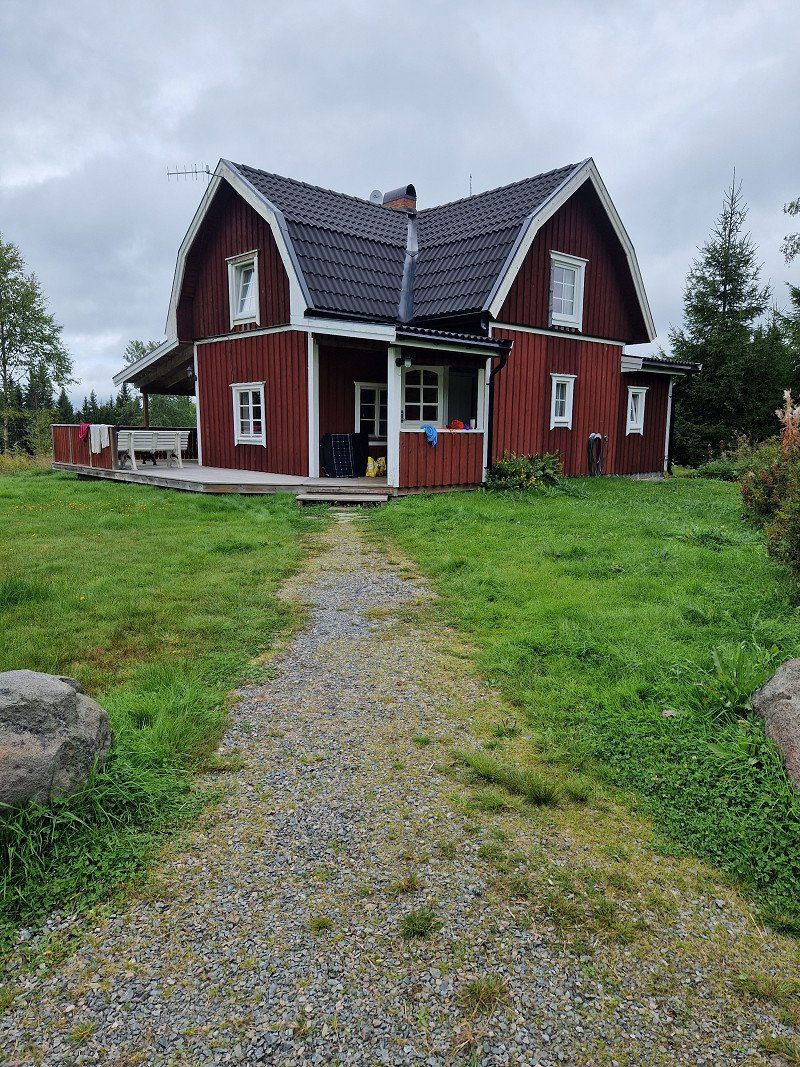
Übernachtung Minicampingplatz bei Säm
Norra Sam
Anneland/Ljung
52493 Herrljunga
Booking totally easy via whatsapp: right on the lake, only 15 places, lovely 😀
https://murum4u.wixsite.com/sams-camping-cafe
Herrljunga, Schweden
58° 0' 59.7" N 13° 12' 44.7" E
58.0165789 13.2124269
• Head northwest. Go for 478 m.
• Turn slightly right onto Vimle kvarn. Go for 274 m.
• Turn left onto Vimle Östergården. Go for 208 m.
• Continue on Vimle Åkaregården. Go for 83 m.
• Continue on Vimle. Go for 22 m.
• Continue on Vimle Skattegården. Go for 133 m.
• Continue on Vimle Bengtgården. Go for 46 m.
• Continue on Vimle Skattegården. Go for 120 m.
• Continue on Vimle Persgården. Go for 300 m.
• Continue on Vimle. Go for 458 m.
• Continue on Skölvene Munkagården. Go for 1.7 km.
• Turn left toward Skölvene bygdegård. Go for 270 m.
• Continue on Skölvene bygdegård. Go for 187 m.
• Continue on Skölvene. Go for 237 m.
• Continue on Skölvene Björkäng. Go for 40 m.
• Continue on Skölvene Lövåsa. Go for 46 m.
• Continue on Skölvene. Go for 87 m.
• Continue on Skölvene Dalen. Go for 35 m.
• Continue on Skölvene. Go for 47 m.
• Turn right toward Ölanda Frisagården. Go for 2.3 km.
• Continue on Ölanda Frisagården. Go for 327 m.
• Continue on Ölanda Långebro. Go for 1.2 km.
• Continue on Hudene Lundagården. Go for 1.1 km.
• Continue on Hudene Anjous. Go for 316 m.
• Continue on Hudene Berget. Go for 67 m.
• Continue on Hudene Kiosk. Go for 136 m.
• Continue on Hudene Knutse. Go for 121 m.
• Continue on Hudene Solhem. Go for 63 m.
• Continue on Hudene Villa Solängen. Go for 52 m.
• Continue on Hudene gamla skola. Go for 67 m.
• Continue on Hudene Björkhaga. Go for 407 m.
• Continue on Hudene norra. Go for 33 m.
• Continue on Ljungholmen Rosenhill. Go for 168 m.
• Continue on Ljungholmen Solhaga. Go for 31 m.
• Continue on Ljungholmen Solgläntan. Go for 24 m.
• Continue on Ljungholmen. Go for 322 m.
• Turn right onto 181. Go for 88 m.
• Turn left onto Stenunga. Go for 99 m.
• Continue on Stenunga Spånggården. Go for 431 m.
• Continue on Stenunga Hulegården. Go for 161 m.
• Continue on Stenunga Ambjörnsgården. Go for 71 m.
• Continue on Stenunga Tolsgården. Go for 632 m.
• Continue on Lättorp. Go for 316 m.
• Continue on Hudenevägen. Go for 1.5 km.
• Turn right onto Vedumsvägen. Go for 3.9 km.
• Continue on Herrljunga Bäcka. Go for 340 m.
• Continue on Bitterna Bjurdamm. Go for 175 m.
• Continue on Bitterna Skogsbacken. Go for 2.8 km.
• Continue on Bitterna Björksäter. Go for 210 m.
• Continue on Bitterna Torsberget. Go for 1.3 km.
• Continue on Bitterna Ölstorp. Go for 167 m.
• Continue on Bitterna Noläng. Go for 1.2 km.
• Continue on Vedum Skolfjärdingen. Go for 634 m.
• Continue on Kyrkolundsgatan. Go for 265 m.
• Turn right onto Larvsvägen. Go for 137 m.
• Turn left onto Varavägen. Go for 1.0 km.
• Continue on Vedum Nolmarken. Go for 118 m.
• Continue on Vedum Solbacka. Go for 157 m.
• Continue on Vedum Nolmarken. Go for 797 m.
• Continue on Södra Lundby Jöstebacken. Go for 2.5 km.
• Continue on Södra Lundby Kroken. Go for 399 m.
• Continue on Önum Marbäck. Go for 701 m.
• Continue on Önum Rangeltorp. Go for 1.6 km.
• Continue on Önum Fornstugan. Go for 1.2 km.
• Continue on Önum Djäknagården. Go for 1.1 km.
• Continue on Önum Heljeved. Go for 319 m.
• Continue on Heljevedsvägen. Go for 647 m.
• Turn right onto Östra Ringleden (187). Go for 1.8 km.
• Take the 2nd exit from roundabout onto Östra Ringleden (187). Go for 3.4 km.
• Turn left onto 47/187. Go for 16.9 km.
• Take the 2nd exit from roundabout onto Södergatan. Go for 3.6 km.
• Continue on Flo Logårdsbro. Go for 1.1 km.
• Continue on Flo Hildeberg toward Uddevalla/Trollhättan. Go for 343 m.
• Continue toward Uddevalla/Trollhättan. Go for 38 m.
• Take the 3rd exit from roundabout onto 44/47 toward Uddevalla/Trollhättan. Go for 2.0 km.
• Pass 2 roundabouts and continue on 42/44/47. Go for 17.6 km.
• Continue on E45. Go for 3.8 km.
• Take ramp onto E45 toward Uddevalla/Karlstad/Båberg. Go for 2.8 km.
• Continue on 44. Go for 17.0 km.
• Take ramp onto 44 toward Uddevalla. Go for 8.8 km.
• Take the 2nd exit from roundabout onto 44 toward E6. Go for 2.9 km.
• Turn right and take ramp onto E6 toward Oslo. Go for 22.0 km.
• Take exit 101 toward Lysekil/Dingle/165/Kungshamn/171/Hunnebostrand/Smögen. Go for 206 m.
• Take the 3rd exit from roundabout onto 162. Go for 5.8 km.
• Take the 1st exit from roundabout onto 171. Go for 6.5 km.
• Take the 2nd exit from roundabout onto Åby Varpet (171). Go for 7.3 km.
• Turn left onto Lycke (171). Go for 2.3 km.
• Turn left onto Örn. Go for 1.1 km.
• Continue on Örn Smedjan. Go for 46 m.
• Continue on Örn. Go for 74 m.
• Continue on Örn Solebo. Go for 63 m.
• Continue on Örn. Go for 145 m.
• Continue on Örn Solliden. Go for 236 m.
• Continue on Håle Kusthus. Go for 1.5 km.
• Continue on Rörvik Östergård Toreborg. Go for 92 m.
• Continue on Bua Björkliden. Go for 865 m.
• Turn slightly left onto Bua. Go for 170 m.
• Continue on Bua Roparebacken. Go for 99 m.
• Continue on Bua. Go for 24 m.
• Continue on Bua Roparebacken. Go for 294 m.
• Take the Bohus-Malmönleden Ferry. Stay on for 659 m.
• Head southwest on Stallen. Go for 489 m.
• Continue on Grönvik. Go for 208 m.
• Continue on Grönviks industriområde. Go for 487 m.
• Turn slightly right onto Engbergs väg. Go for 223 m.
• Turn slightly left onto Strandvägen. Go for 104 m.
• Turn slightly right onto Smithebacken. Go for 169 m.
• Turn left onto Tennisvägen. Go for 88 m.
• Turn right onto Kullebacken. Go for 101 m.
• Turn right onto Kullebacken. Go for 162 m.
• Arrive at Kullebacken. Your destination is on the right.
☍
169,9 km
(2 hrs. 49 min.)
Day
Day
Bohus Malmön, Tageswanderung
https://goo.gl/maps/XAk6UpythMfC567C8
Long term parking, accommodation unclear, but places in the area via Park4Night
Kullebacken 12, 450 45 Bohus-malmön, Schweden
58° 20' 41" N 11° 20' 11.3" E
58.3447258 11.3364722
• Head northwest on Kullebacken. Go for 162 m.
• Turn left onto Kullebacken. Go for 101 m.
• Turn left onto Tennisvägen. Go for 88 m.
• Turn right onto Smithebacken. Go for 169 m.
• Turn slightly left onto Strandvägen. Go for 104 m.
• Turn slightly right onto Strandvägen. Go for 223 m.
• Turn slightly left onto Engbergs väg. Go for 487 m.
• Continue on Grönvik. Go for 208 m.
• Continue on Stallen. Go for 489 m.
• Take the Bohus-Malmönleden Ferry. Stay on for 659 m.
• Head northeast on Bua Roparebacken. Go for 294 m.
• Continue on Bua. Go for 24 m.
• Continue on Bua Roparebacken. Go for 99 m.
• Continue on Bua. Go for 170 m.
• Turn slightly right onto Bua Björkliden. Go for 865 m.
• Continue on Rörvik Östergård Toreborg. Go for 92 m.
• Continue on Håle Kusthus. Go for 1.5 km.
• Continue on Örn Mariero. Go for 236 m.
• Continue on Örn. Go for 145 m.
• Continue on Örn Solebo. Go for 63 m.
• Continue on Örn. Go for 74 m.
• Continue on Örn Smedjan. Go for 46 m.
• Continue on Örn. Go for 1.1 km.
• Turn right onto Amborsröd Änghyddan (171). Go for 2.3 km.
• Turn right onto Lycke (171). Go for 7.3 km.
• Take the 2nd exit from roundabout onto Åby Varpet (171). Go for 2.5 km.
• Turn left onto Nedre Runden. Go for 728 m.
• Continue on Övre Runden. Go for 814 m.
• Continue on Östebo. Go for 1.7 km.
• Continue on Bärfendals-Medbo. Go for 411 m.
• Continue on Skörbo. Go for 514 m.
• Continue on Skörboliden. Go for 239 m.
• Continue on Låssby. Go for 219 m.
• Continue on Myrtorp. Go for 673 m.
• Continue on Myrtorp. Go for 271 m.
• Turn right onto 174. Go for 5.0 km.
• Turn right and take ramp onto E6 toward Oslo/Strömstad. Go for 53.0 km.
• Take exit 111 toward E18/Strömstad S C/Åmål. Go for 203 m.
• Take the 3rd exit from roundabout onto 164 toward E18/Strömstad. Go for 4.6 km.
• Take the 2nd exit from roundabout toward E18/Centrum. Go for 48 m.
• Continue on Uddevallavägen. Go for 1.4 km.
• Continue on Uddevallavägen toward Centrum. Go for 55 m.
• Arrive at Uddevallavägen. Your destination is on the right.
☍
89,3 km
(1 hrs. 41 min.)
Day
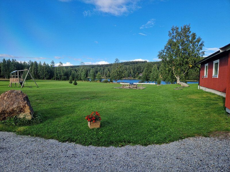
Nähe Strömstad: Übernachtung Campingplatz
Lagoon Camping
Very nice campsite! dog friendly
Nordkoster (we left it out):
Ferry from Strömstad to the North Island - car-free - circumnavigation approx. 8km It's just so beautiful, we have to go there! Maybe the Austs will come with me? https://www.nationalparksofsweden.se/de/nationalpark-wahlen/kosterhavet-nationalpark/ https://compass-stories.de/schwedens-westkueste-die-schoensten-orte/
Uddevallavägen, 452 30 Strömstad, Schweden
58° 56' 6.5" N 11° 10' 17.6" E
58.9351501 11.1715463
• Head toward Torskholmen on Uddevallavägen. Go for 308 m.
• Continue on Parkgatan. Go for 58 m.
• Turn left onto Skolgatan. Go for 77 m.
• Turn slightly left onto Västra Klevgatan. Go for 7 m.
• Turn left onto Badhusgatan. Go for 35 m.
• Turn slightly right onto Badhusgatan. Go for 99 m.
• Turn right onto Uddevallavägen. Go for 1.6 km.
• Continue toward 164. Go for 39 m.
• Take the 2nd exit from roundabout onto 164 toward E6. Go for 4.6 km.
• Take the 2nd exit from roundabout onto 164 toward Åmål/Skee/Krokstrand. Go for 1.2 km.
• Take the 2nd exit from roundabout onto 164 toward Åmål/Bullarebygden. Go for 20.9 km.
• Turn left toward Vassbotten. Go for 4.3 km.
• Continue on Vassbotten. Go for 33 m.
• Turn left onto 165. Go for 137 m.
• Turn right onto Vassbotten toward Fagerhult. Go for 285 m.
• Turn left toward Ällelien. Go for 163 m.
• Continue on Ällelien. Go for 249 m.
• Turn slightly left onto Ällelien. Go for 580 m.
• Continue on Ällelien Berget. Go for 227 m.
• Arrive at Ällelien Berget. Your destination is on the left.
☍
34,9 km
( 34 min.)
Day
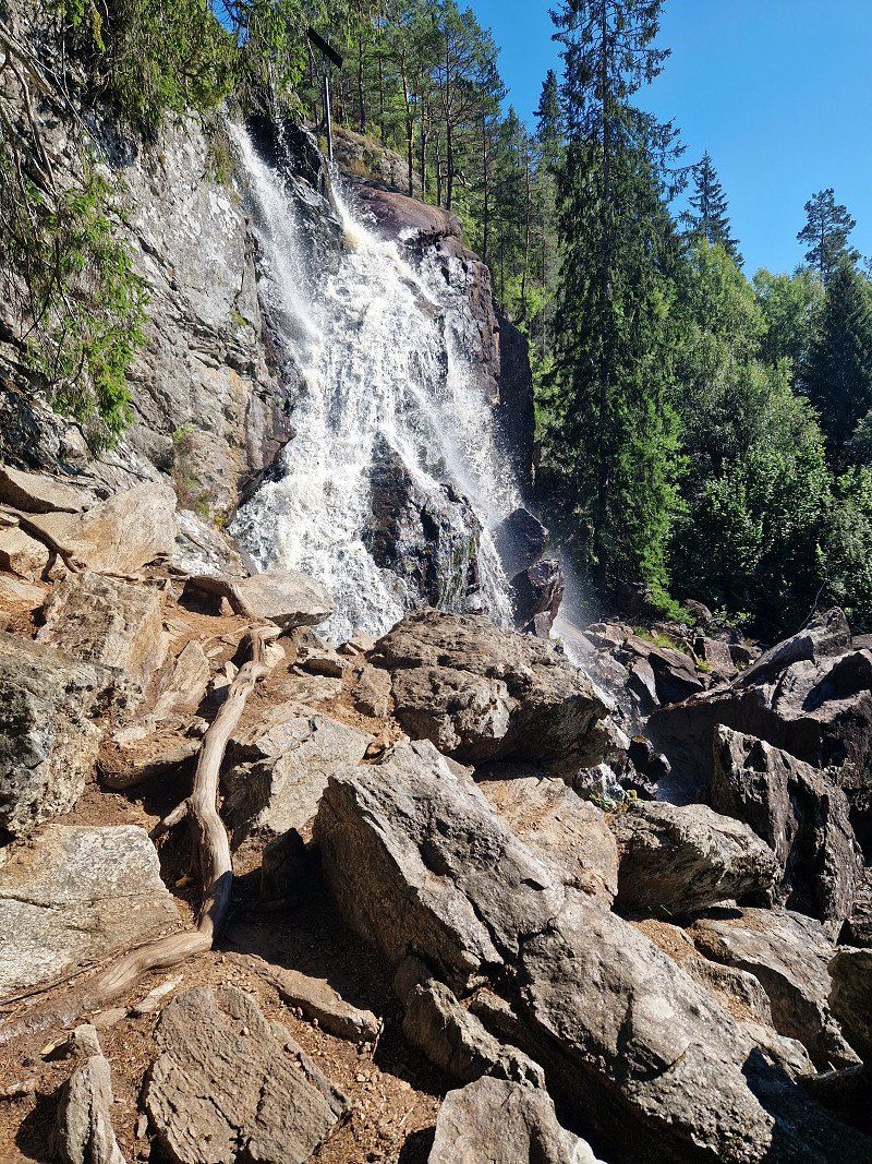
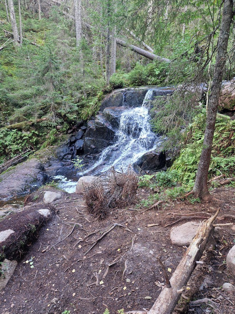
Älgafallet / Elgafossen Wasserfall, Schweden
VGPQ+GMQ Vassbotten, Schweden
58° 53' 10.8" N 11° 32' 21.2" E
58.8863468 11.5392283
• Head southwest on Ällelien Berget. Go for 227 m.
• Continue on Ällelien. Go for 580 m.
• Turn slightly right toward Ällelien. Go for 145 m.
• Continue on Ällelien. Go for 104 m.
• Continue toward Vassbotten. Go for 163 m.
• Turn right onto Vassbotten. Go for 285 m.
• Turn right onto Vassbotten (165). Go for 241 m.
• Continue on Enningdalsveien (220). Go for 30.1 km.
• Turn right onto Øbergveien (103) toward Tistedal. Go for 2.9 km.
• Continue on Georg Feydts gate (103). Go for 115 m.
• Turn right onto Aremarkveien (21). Go for 12.0 km.
• Turn left onto Aremarkveien (21) toward Aremark/Ørje. Go for 42.9 km.
• Take the 2nd exit from roundabout onto Haldenveien toward E18. Go for 232 m.
• Continue on Svenskeveien (E18). Go for 5.9 km.
• Continue on E18. Go for 11.0 km.
• Turn left onto Leverbyn Skålerud toward Arvika/Vännacka. Go for 271 m.
• Continue on Leverbyn. Go for 469 m.
• Continue on Leverbyn Betania. Go for 411 m.
• Continue on Leverbyn. Go for 85 m.
• Continue on Leverbyn Tjärnstomt. Go for 119 m.
• Continue on Leverbyn. Go for 303 m.
• Continue toward Bergerud Martinstuga. Go for 1.2 km.
• Continue on Bergerud Martinstuga. Go for 331 m.
• Continue on Bergerud. Go for 1.6 km.
• Continue on Pikstad Änga. Go for 294 m.
• Continue on Pikstad. Go for 2.0 km.
• Continue on Västra Bön Intaket. Go for 371 m.
• Continue on Hämnäs. Go for 1.1 km.
• Continue on Hämnäs. Go for 959 m.
• Continue on Hämnäs Nedre Åmot. Go for 221 m.
• Continue on Knåll Ängsvallen. Go for 971 m.
• Continue on Bjärn. Go for 122 m.
• Continue on Stommen Änga. Go for 716 m.
• Continue on Bjärn. Go for 2.6 km.
• Continue on Vännacka. Go for 1.3 km.
• Continue on Vännacka Hjalmars Affär. Go for 247 m.
• Continue on Vännacka. Go for 308 m.
• Turn left onto 177. Go for 24.9 km.
• Turn left toward Rudsgården Älvbacka. Go for 247 m.
• Continue on Rudsgården Älvbacka. Go for 856 m.
• Continue on Bålstad Björkebo. Go for 510 m.
• Continue on Bålstad Sönnaråsen. Go for 152 m.
• Continue on Bålstad Lilla Nygård. Go for 161 m.
• Continue on Bålstad backen. Go for 357 m.
• Continue on Bålstad Flobacken. Go for 123 m.
• Continue on Bålstad Bussebo. Go for 266 m.
• Continue on Bålstad Skogtun. Go for 150 m.
• Continue on Bålstad Hagaberg. Go for 90 m.
• Continue on Bålstad Hagalund. Go for 458 m.
• Continue on Bålstad Kvarntorpet. Go for 317 m.
• Continue on Bålstad Björkås. Go for 771 m.
• Continue on Bålstad Branäset. Go for 611 m.
• Continue on Adolfsfors Björkhagen. Go for 116 m.
• Continue on Adolfsfors Hamra. Go for 95 m.
• Turn left. Go for 205 m.
• Turn right toward Adolfsfors Älvängen. Go for 186 m.
• Continue on Adolfsfors Älvängen. Go for 547 m.
• Continue on Gryttved norra Sjöbacka. Go for 349 m.
• Continue on Gryttved Bergshamra. Go for 250 m.
• Continue on Gryttved Solstrand. Go for 135 m.
• Continue on Gryttved Lilla Solstrand. Go for 426 m.
• Continue on Gryttved Bergvik. Go for 499 m.
• Continue on Gryttved Sandvika. Go for 2.3 km.
• Continue on Kortlanda Björkbacka. Go for 363 m.
• Continue on Kortlanda Hagaborg. Go for 326 m.
• Continue on Kortlanda västra Berget. Go for 1.6 km.
• Continue on Nolby Lilla Nolbybråten. Go for 454 m.
• Continue toward Nolby Bytjärnsåsen. Go for 47 m.
• Continue on Nolby Bytjärnsåsen. Go for 942 m.
• Continue on Mellbyn Nordäng. Go for 113 m.
• Continue on Mellbyn Bröta. Go for 195 m.
• Continue on Mellbyn Tveten. Go for 634 m.
• Turn left toward Ås Janstorpet. Go for 156 m.
• Continue on Ås Janstorpet. Go for 226 m.
• Continue on Ås Bröta. Go for 315 m.
• Continue on Ås Bostället. Go for 345 m.
• Continue on Ås Skogslund. Go for 832 m.
• Continue on Ås Älven. Go for 1.2 km.
• Continue on Ås Lövåsen. Go for 55 m.
• Continue on Ås Torpet. Go for 659 m.
• Turn right toward Stora Hög Säterbo. Go for 2.3 km.
• Continue on Stora Hög Säterbo. Go for 843 m.
• Continue on Stora Hög Dyckelstorp. Go for 1.3 km.
• Continue on Norra Fjäll Lilla Torpet. Go for 623 m.
• Continue on Norra Fjäll Bergtorp. Go for 357 m.
• Continue on Norra Fjäll Missionshus. Go for 401 m.
• Continue on Fjällby Fjällbacka. Go for 282 m.
• Continue on Norra Fjäll Öststuga. Go for 2.6 km.
• Continue on Gröttvål Verkstaden. Go for 101 m.
• Continue on Allstakan Älvnäs. Go for 336 m.
• Continue on Allstakan Marielund. Go for 539 m.
• Continue on Allstakan Björkebo. Go for 220 m.
• Continue on Allstakan Björkbacken. Go for 367 m.
• Continue on Allstakan Herrgårdsvikens Såg. Go for 31 m.
• Continue on Allstakan Bergbacka. Go for 406 m.
• Continue on Allstakan Solbacka. Go for 395 m.
• Continue on Allstakan Sundet. Go for 268 m.
• Continue on Kolstan Sundby. Go for 94 m.
• Turn left toward Kolstan Nedre Tomta. Go for 84 m.
• Continue on Kolstan Nedre Tomta. Go for 982 m.
• Continue on Kolstan Solbacken. Go for 1.7 km.
• Continue on Kolstan Vikebo. Go for 333 m.
• Continue on Bortan Krokhultet. Go for 399 m.
• Continue on Bortan södra Åsen. Go for 789 m.
• Continue on Bortan Björkhagen. Go for 209 m.
• Continue on Bortan Gunnarsby. Go for 551 m.
• Arrive at your destination.
☍
182,8 km
(2 hrs. 43 min.)
Bortan
Bortan, near Gunnarskog/Värmland
*****
Alternatives for overnight stays:
Bredviken Torsby or
Camping Tyngsjo Vildmark
Tyngsjo Stugby 6
78694 / Tyngsjö/Äppelbo
Sweden
Knut's Stugby & Camping: https://www.freeontour.com/de/pitches/knuts-stugby-camping-torsby
670 35, Schweden
59° 55' 49.5" N 12° 31' 14.7" E
59.9304155 12.5207586
• Head south. Go for 467 m.
• Continue on Bortan Gunnarsby. Go for 84 m.
• Continue on Bortan Björkhagen. Go for 546 m.
• Continue on Bortan södra Åsen. Go for 504 m.
• Continue on Bortan Krokhultet. Go for 416 m.
• Continue on Kolstan Vikebo. Go for 1.5 km.
• Continue on Kolstan Solbacken. Go for 959 m.
• Continue on Kolstan Nedre Tomta. Go for 501 m.
• Turn left onto Kolstan Sundvik. Go for 512 m.
• Continue on Klanderud Solliden. Go for 664 m.
• Continue on Tvärud Nyhem. Go for 367 m.
• Continue on Tvärud Marielund. Go for 63 m.
• Continue on Tvärud Nyhem. Go for 841 m.
• Turn left toward Bergatorp Där Oppe. Go for 154 m.
• Continue on Bergatorp Där Oppe. Go for 419 m.
• Continue on Järperud Bygdegården. Go for 1.7 km.
• Continue on Järperud Solbacken. Go for 686 m.
• Continue on Järperud Lillebo. Go for 278 m.
• Continue on Järperud Torpet. Go for 172 m.
• Continue on Järperud Broby. Go for 59 m.
• Continue on Forsbacka Badhuset. Go for 867 m.
• Continue on Södra Treskog Solbacken. Go for 52 m.
• Continue on Södra Treskog Nygård. Go for 871 m.
• Continue on Södra Treskog Håkastomta. Go for 420 m.
• Continue on Södra Treskog Källås. Go for 1.3 km.
• Continue on Södra Treskog Sjöviken. Go for 3.7 km.
• Continue on Fredros Björkliden. Go for 1.1 km.
• Continue on Fredros Björkhem. Go for 3.1 km.
• Continue on Mången Åsen. Go for 530 m.
• Continue on Mången Sandviken. Go for 516 m.
• Continue on Mången Norastugan. Go for 743 m.
• Continue on Mangen. Go for 2.3 km.
• Continue on Humsjön. Go for 2.4 km.
• Continue on Ragvaldstjärn. Go for 1.1 km.
• Continue toward Trötvik. Go for 3.3 km.
• Continue on Trötvik. Go for 1.8 km.
• Turn left onto Trötvik. Go for 378 m.
• Continue on Portnär. Go for 566 m.
• Continue on Vålön. Go for 1.2 km.
• Continue on Kyrkogatan. Go for 430 m.
• Turn left onto Gräsmarksvägen. Go for 2.6 km.
• Continue on Granbäck. Go for 2.0 km.
• Continue on Forsnäs. Go for 566 m.
• Turn right onto Forsnäs. Go for 743 m.
• Continue on Hedås. Go for 1.2 km.
• Continue on Bastnäs. Go for 6.4 km.
• Continue on Gräsmarksvägen. Go for 8.2 km.
• Continue on Västanå. Go for 2.3 km.
• Turn right onto Västanå (E16) toward Torsby. Go for 2.0 km.
• Take the 3rd exit from roundabout onto Inlandsvägen (E16/E45) toward Mora/Hagfors. Go for 85.1 km.
• Take the 3rd exit from roundabout onto Västerdalsvägen (66) toward Sälen. Go for 62.1 km.
• Take the 1st exit from roundabout onto Sälenvägen (311). Go for 69.4 km.
• Turn left onto Särnavägen (70). Go for 4.4 km.
• Turn left toward Gördalen/Fulufjällets nationalpark/Njupeskär/Mörkret/Fulufjällsbyn. Go for 15.9 km.
• Continue toward Mörkret. Go for 4.6 km.
• Turn left onto Mörkret. Go for 234 m.
• Continue on Mörkret Där Västigen. Go for 2.4 km.
• Continue on Stormorvallen. Go for 279 m.
• Continue on Björbäckstugan. Go for 1.3 km.
• Arrive at Björbäckstugan. Your destination is on the right.
☍
309,3 km
(4 hrs. 12 min.)
Day
Day
Day
Day
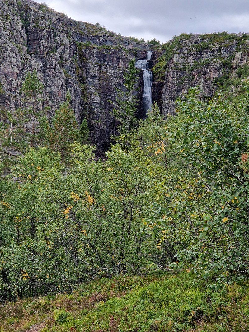
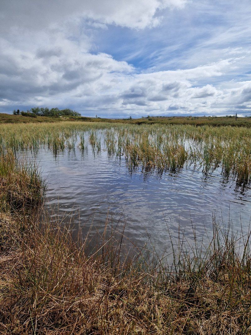
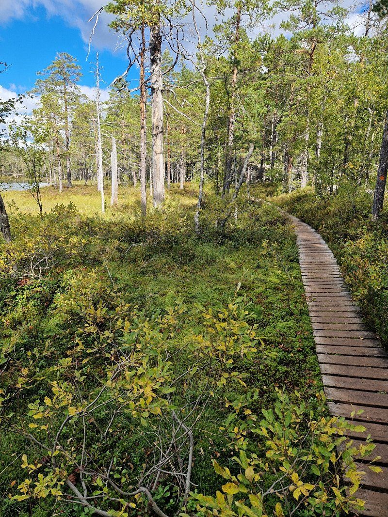
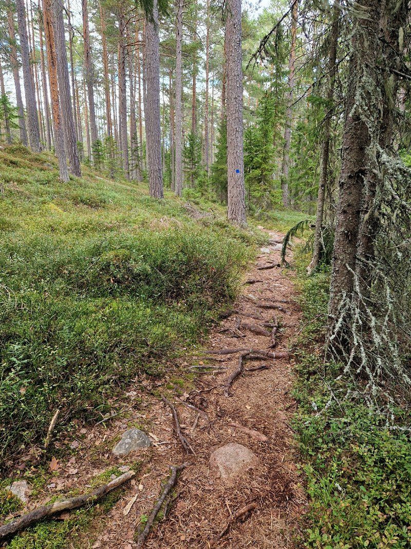
* Fulufjällets Nationalpark (am Njupeskärs Vattenfall)
The journey up to the park alone is mega, the Fulufjället itself is also great! The "black tours" go over rocks, which are also difficult for dogs to walk on. But there are ways around it... You can find our tour with dogs (12km) on Komoot.
We stayed 2 nights right on the river, before Mörkret. Wide gravel road, no disposal etc.
- - -
* Waterfall
* ancient trees, oldest tree in the world
camping
nearby: https://www.stotencamping.se/en/products/campingplats-husvagn-med-el (290/320 K - night)
Info:
https://www.schweden-urlauber.info/fulufjaellet-nationalpark-fulufjaell-saerna-camping/
790 90 Mörkret, Schweden
61° 38' 4.8" N 12° 43' 16.2" E
61.6346792 12.7211564
• Head southeast on Björbäckstugan. Go for 1.3 km.
• Continue on Stormorvallen. Go for 279 m.
• Continue toward Mörkret Där Västigen. Go for 2.0 km.
• Continue on Mörkret Där Västigen. Go for 447 m.
• Continue on Mörkret. Go for 234 m.
• Turn right. Go for 4.6 km.
• Continue toward 70. Go for 16.0 km.
• Turn right onto 70. Go for 5.5 km.
• Turn left onto Östomsjövägen toward Sveg/Lillhärdal/Östomsjön. Go for 180 m.
• Continue on Thyskvägen. Go for 248 m.
• Continue on Östomsjövägen. Go for 29.5 km.
• Continue on Fallvallen. Go for 3.8 km.
• Continue on Lövnäsvallen. Go for 1.4 km.
• Continue on Lövnäsvallen. Go for 7.6 km.
• Continue on Särnavägen. Go for 18.8 km.
• Continue on Forsmovägen. Go for 1.2 km.
• Continue on Backgränd. Go for 254 m.
• Continue on Olov Högmans väg. Go for 266 m.
• Continue on Härjulfs väg. Go for 969 m.
• Continue on Nordanhå. Go for 1.2 km.
• Continue on Nordanhå. Go for 26.1 km.
• Turn sharp left onto Ulvkälla (E45). Go for 1.3 km.
• Turn right onto Vallarvägen (E45) toward Östersund/Hudiksvall/Flygplats. Go for 45.0 km.
• Turn right onto Ångevägen (314). Go for 41.6 km.
• Turn right onto Kölsillre (315). Go for 15.3 km.
• Turn left onto 83. Go for 30.4 km.
• Turn right onto E14 toward Sundsvall. Go for 44.5 km.
• Turn right onto Fanbyvägen (305) toward Hassela. Go for 993 m.
• Turn left onto Uslandsvägen (305). Go for 11.3 km.
• Turn right toward Sörvigge. Go for 693 m.
• Continue on Sörvigge. Go for 2.4 km.
• Arrive at Sörvigge. Your destination is on the right.
☍
315,1 km
(4 hrs. 6 min.)
Day
Day
Zwischenübernachtung: kleiner Campingplatz am See
Camping Jannesland, Sörvigge, 864 95 Stöde, Sweden
Small nice campsite, closes mid-September, we were there alone...
SÖRVIGGE 118, 860 13 Stöde, Schweden
62° 19' 27.1" N 16° 39' 58.2" E
62.3241970 16.6661679
• Head southwest on Sörvigge. Go for 3.1 km.
• Turn right onto 305. Go for 3.6 km.
• Turn left toward Vigge. Go for 346 m.
• Continue on Vigge. Go for 1.0 km.
• Continue on Grössjön. Go for 1.6 km.
• Continue toward Grössjön. Go for 128 m.
• Continue on Grössjön. Go for 2.5 km.
• Continue on Myssjön. Go for 544 m.
• Continue on Myssjön. Go for 2.2 km.
• Continue on Lyngstern. Go for 7.3 km.
• Continue on Rännö. Go for 882 m.
• Continue on Rännö. Go for 677 m.
• Continue on Rännö. Go for 422 m.
• Continue on Rännö. Go for 861 m.
• Continue on Rännövägen. Go for 1.0 km.
• Turn left onto Rännövägen. Go for 252 m.
• Continue on Skölevägen. Go for 834 m.
• Continue on Storjordenvägen. Go for 1.1 km.
• Turn left toward E14. Go for 193 m.
• Take ramp onto E14. Go for 12.5 km.
• Keep left toward E4/Flygplats/Haparanda/86/Bispgården/Industriområde Tunadalshamnen. Go for 97 m.
• Continue on E14. Go for 33 m.
• Keep left onto 86 toward E4/Flygplats/Haparanda/Bispgården/Industriområde Tunadalshamnen. Go for 1.6 km.
• Pass 2 roundabouts and continue on Timmervägen. Go for 7.6 km.
• Take the 2nd exit from roundabout onto Ljustavägen toward E4/Flygplats/Haparanda/Alnö/Sundsbruk. Go for 305 m.
• Take ramp onto E4 toward Haparanda/Flygplats. Go for 43.4 km.
• Keep left onto E4 toward Haparanda/Sollefteå/90. Go for 72.5 km.
• Turn right toward Skuleskogens nationalpark. Go for 299 m.
• Turn slightly left toward Dalsjövägen. Go for 843 m.
• Turn right onto Dalsjövägen. Go for 271 m.
• Turn slightly left. Go for 1.8 km.
• Arrive at your destination.
☍
169,7 km
(2 hrs. 16 min.)
Day
Skuleskogens nationalpark, Entré Väst, Skule, Schweden
Fantastic national park, especially for fans of the Elbe Sandstone Mountains!!
We did a little tour of the west entrance and drove to the north entrance to spend the night. Toilets at the park entrance, we stood in front of the official parking lot for 2 nights, the north hiking tour starts from there. The first night we were alone there, the second it was much fuller (Friday) but still okay.
The south entrance was too crowded for us (it was also a Saturday + a trail run), so with a heavy heart we canceled the planned tour and continued straight away.
Coming from the north side there is a super great rest area at the top, right on the lake, there are also two nice huts where you can stay overnight, toilets and barbecue facilities.
https://www.sverigesnationalparker.se/de/nationalpark-wahlen/skuleskogen-nationalpark/
Info:
https://fraeulein-draussen.de/wandern-hoga-kusten-skuleskogen/ (south entrance)
https://compass-stories.de/wandern-im-skuleskogen-nationalpark/ (North and South entrances)
893 91 Skule, Schweden
63° 7' 14.4" N 18° 25' 40.2" E
63.1206568 18.4278388
• Head southwest. Go for 1.8 km.
• Turn slightly right onto Dalsjövägen. Go for 271 m.
• Turn left. Go for 1.1 km.
• Turn right toward E4. Go for 29 m.
• Turn left onto E4. Go for 66.6 km.
• Turn right toward Norrstig. Go for 24 m.
• Continue on Norrstig. Go for 345 m.
• Continue on Långslätten. Go for 1.4 km.
• Continue on Söderstig. Go for 1.1 km.
• Continue on Byåker. Go for 639 m.
• Turn right toward Billsta. Go for 2.6 km.
• Continue on Billsta. Go for 748 m.
• Turn left toward Nyland Erikslund. Go for 134 m.
• Continue on Nyland Erikslund. Go for 145 m.
• Continue on Nyland. Go for 3.6 km.
• Continue on Tjärnsjö. Go for 1.2 km.
• Continue on Tjärnsjö. Go for 140 m.
• Continue on Antjärn. Go for 404 m.
• Turn right onto E4. Go for 142 km.
• Take ramp toward Enånger. Go for 276 m.
• Continue on Bäckmoravägen. Go for 849 m.
• Continue on Änga. Go for 427 m.
• Continue toward Militärvägen. Go for 170 m.
• Continue on Militärvägen. Go for 388 m.
• Continue on Enångersvägen. Go for 154 m.
• Turn right onto Bureborgsvägen. Go for 256 m.
• Continue on Tytterövägen. Go for 642 m.
• Continue on Borkavägen. Go for 1.4 km.
• Arrive at Borkavägen. Your destination is on the right.
☍
228,9 km
(2 hrs. 38 min.)
Day
Day
Borka Stugby Camping
825 95 Enånger, Schweden
61° 32' 55.1" N 17° 2' 35.3" E
61.5486263 17.0431281
• Head northwest on Borkavägen. Go for 1.4 km.
• Continue on Tytterövägen. Go for 642 m.
• Continue on Bureborgsvägen. Go for 256 m.
• Turn left onto Enångersvägen. Go for 154 m.
• Continue on Militärvägen. Go for 388 m.
• Turn left toward Berghem. Go for 1.3 km.
• Continue on Berghem. Go for 1.4 km.
• Continue on Tosätter. Go for 872 m.
• Continue on Vedmora. Go for 4.2 km.
• Continue on Lindefallet. Go for 95 m.
• Continue on Lindefallet. Go for 3.7 km.
• Continue on Kilmora. Go for 2.1 km.
• Continue on Svalarna. Go for 2.2 km.
• Continue on Alebo. Go for 459 m.
• Continue on Alebo. Go for 1.5 km.
• Continue on Losemyra. Go for 3.1 km.
• Continue on Å. Go for 675 m.
• Continue on Torsängsvägen. Go for 444 m.
• Turn right onto Fors. Go for 218 m.
• Continue on Norrala-Nygården. Go for 272 m.
• Continue on Norrala-Nygården. Go for 144 m.
• Continue on Fors. Go for 4.4 km.
• Continue on Trönbyn Stenbronäs. Go for 59 m.
• Continue on Trönbyn. Go for 603 m.
• Continue on Trönbyn. Go for 365 m.
• Continue on Trönbyn. Go for 337 m.
• Continue on Hällsätter. Go for 195 m.
• Continue on Hällsätter. Go for 1.1 km.
• Continue on Lertagsvägen. Go for 116 m.
• Turn left onto Lertagsvägen. Go for 233 m.
• Continue on VI. Go for 380 m.
• Continue on VI. Go for 8.7 km.
• Turn right onto Bergslagsdiagonalen (50). Go for 16.9 km.
• Turn left onto Bergslagsdiagonalen (50/83) toward Ånge. Go for 923 m.
• Take the 2nd exit from roundabout onto Bergslagsdiagonalen (50) toward Falun/Edsbyn/301. Go for 20.6 km.
• Continue on 301 toward Rättvik/Edsbyn. Go for 13.4 km.
• Pass 2 roundabouts and continue on Furudal Furudalsvägen (296/301). Go for 54.2 km.
• Turn right onto 296 toward Orsa. Go for 29.3 km.
• Turn slightly left onto Heden (E45) toward Mora/Orsa. Go for 3.9 km.
• Pass 6 roundabouts and continue on Vasagatan (E45). Go for 14.6 km.
• Take the 2nd exit from Cirkulationsplats Stranden roundabout onto Älvgatan (70). Go for 504 m.
• Take the 1st exit from roundabout onto Badstubacksbron (70) toward Röros/Idre/Älvdalen. Go for 681 m.
• Take the 1st exit from roundabout onto Vasalidsvägen. Go for 710 m.
• Arrive at Vasalidsvägen.
☍
197,6 km
(2 hrs. 33 min.)
Day
Tageswanderungen Orsa oder Mora
https://www.swedishtouristassociation.com/trails/siljansleden/
Beautiful trails around Mora Lake, circular tours
Nice trail at Osra
camping: First Camp Osra (with sauna)
2H92+CF Mora, Schweden
61° 1' 6.7" N 14° 33' 4.5" E
61.0185256 14.5512480
• Head southeast on Vasalidsvägen. Go for 696 m.
• Take the 3rd exit from roundabout onto Badstubacksbron (70). Go for 705 m.
• Take the 2nd exit from roundabout onto Älvgatan (70) toward E45/Östersund/Karlstad/26/Mariestad/Enköping. Go for 488 m.
• Take the 2nd exit from Cirkulationsplats Stranden roundabout onto Vasagatan (E45). Go for 377 m.
• Take the 2nd exit from Cirkulationsplats Resecentrum roundabout onto Vasagatan (E45). Go for 421 m.
• Take the 2nd exit from Cirkulationsplats Broåkern roundabout onto Vasagatan (E45). Go for 1.4 km.
• Take the 2nd exit from roundabout onto 70 toward Enköping. Go for 986 m.
• Pass 6 roundabouts and continue on Riksvägen (70). Go for 37.0 km.
• Turn left onto 69 toward Falun/Vidablick. Go for 41.9 km.
• Take the 3rd exit from roundabout onto Bergslagsdiagonalen (E16) toward Gävle/Fagersta/Söderhamn/Lugnet. Go for 2.6 km.
• Pass 5 roundabouts and continue on Korsnäsvägen (E16). Go for 8.6 km.
• Take ramp toward Hedemora. Go for 196 m.
• Continue on 69. Go for 37.4 km.
• Take the 3rd exit from roundabout onto 69/70 toward Fagersta/Enköping/Avesta. Go for 1.7 km.
• Take the 2nd exit from roundabout onto 69/70 toward Fagersta/Enköping. Go for 27.4 km.
• Turn left toward By/Folkärna. Go for 338 m.
• Continue on Kvarnbro. Go for 1.3 km.
• Continue on Hyttnäs. Go for 1.2 km.
• Continue on Utsund. Go for 2.0 km.
• Continue on Bäsinge. Go for 1.1 km.
• Continue on Bäsinge. Go for 801 m.
• Continue on Lövsveden. Go for 232 m.
• Continue on Lövsveden. Go for 1.1 km.
• Continue on Mestaäng. Go for 2.3 km.
• Continue on Jugansbo. Go for 1.2 km.
• Continue on Södra Rudu. Go for 1.9 km.
• Continue on Färjan. Go for 336 m.
• Turn left onto Färjan. Go for 458 m.
• Continue on Näsvägen. Go for 493 m.
• Turn right onto Näsvägen. Go for 61 m.
• Arrive at Näsvägen. Your destination is on the left.
☍
176,7 km
(2 hrs. 12 min.)
Day
Falkudden Camping, cafe och Stugby, Näsvägen, By Kyrkby, Schweden
Näsvägen 4, 774 99 By Kyrkby, Schweden
60° 10' 53.1" N 16° 28' 47.4" E
60.1814150 16.4798201
• Head southwest on Näsvägen. Go for 61 m.
• Turn left onto Näsvägen. Go for 839 m.
• Continue on Färjan. Go for 112 m.
• Turn right toward Färjan. Go for 132 m.
• Continue on Färjan. Go for 677 m.
• Continue on Södra Rudu. Go for 2.2 km.
• Continue on Jugansbo. Go for 1.4 km.
• Continue on Mestaäng. Go for 2.1 km.
• Continue on Lövsveden. Go for 485 m.
• Continue on Lövsveden. Go for 601 m.
• Continue on Bäsinge. Go for 1.3 km.
• Continue on Bäsinge. Go for 1.0 km.
• Continue on Utsund. Go for 2.1 km.
• Continue on Hyttnäs. Go for 502 m.
• Continue on Kvarnbro. Go for 1.5 km.
• Turn right onto 70. Go for 7.5 km.
• Take ramp onto 68 toward Örebro/Krylbo/Centrum. Go for 586 m.
• Take the 2nd exit from roundabout onto 68 toward Örebro/Centrum. Go for 1.2 km.
• Pass 2 roundabouts and continue on 68. Go for 28.4 km.
• Turn right toward Årnebo. Go for 2.4 km.
• Continue on Årnebo. Go for 1.9 km.
• Continue on Kolpebo Danskbo. Go for 347 m.
• Continue on Skogsbyn. Go for 713 m.
• Continue on Landsvägen. Go for 44 m.
• Continue on Brickmans väg. Go for 60 m.
• Continue on Landsvägen. Go for 2.8 km.
• Continue on Gångvägen. Go for 535 m.
• Continue on Landsvägen. Go for 2.0 km.
• Continue on Sörbovägen. Go for 3.5 km.
• Continue on Sörängsvägen. Go for 1.7 km.
• Continue on Bärkevägen. Go for 2.0 km.
• Turn right onto 66. Go for 11.9 km.
• Pass 3 roundabouts and continue on Bergslagsdiagonalen (50/66). Go for 13.3 km.
• Turn left onto Grangärdevägen (66/245) toward Hagfors/Fredriksberg/Björbo/Grangärde/Hammarbacken/Sälen. Go for 16.6 km.
• Turn left onto 245. Go for 3.7 km.
• Turn right onto Fredriksbergsvägen (245). Go for 47.8 km.
• Turn left onto 26/245. Go for 13.5 km.
• Turn right onto 245 toward Hagfors/Rämmen. Go for 15.1 km.
• Turn right onto 246. Go for 14.5 km.
• Take the 1st exit from roundabout onto Parkvägen. Go for 485 m.
• Turn right onto Abborrtorpsvägen. Go for 876 m.
• Continue on Abborrtorp. Go for 1.2 km.
• Continue on Abborrängen. Go for 208 m.
• Continue on Abborrängen Koppartorpet. Go for 846 m.
• Continue on Gällälven. Go for 527 m.
• Turn left onto Hörnsätern. Go for 5.3 km.
• Turn right. Go for 230 m.
• Arrive at your destination on the left.
☍
216,5 km
(3 hrs. 2 min.)
4M88+85 Hagfors, Schweden
60° 6' 57.1" N 13° 39' 55.5" E
60.1158625 13.6654163
• Head south. Go for 230 m.
• Turn left. Go for 33 m.
• Turn slightly right toward Hörnsätern. Go for 3.1 km.
• Continue on Hörnsätern. Go for 2.2 km.
• Turn right onto Gällälven. Go for 1.0 km.
• Continue on Abborrängen. Go for 368 m.
• Continue on Abborrängen. Go for 208 m.
• Continue on Abborrtorp. Go for 1.2 km.
• Continue on Abborrtorpsvägen. Go for 876 m.
• Turn left onto Parkvägen. Go for 472 m.
• Take the 3rd exit from roundabout onto 246. Go for 55.1 km.
• Turn left onto Hertig Karlsgatan (63). Go for 324 m.
• Pass 2 roundabouts and continue on Hertig Karlsgatan (63). Go for 550 m.
• Turn right onto Nykroppavägen (26) toward Mariestad/Kristinehamn. Go for 120 m.
• Pass 3 roundabouts and continue on 26. Go for 21.7 km.
• Turn left onto Stationsgatan (237) toward Karlskoga. Go for 23.5 km.
• Turn right onto 205. Go for 4.3 km.
• Take the 2nd exit from roundabout onto Drottningvägen (205/237). Go for 2.1 km.
• Take the 2nd exit from roundabout onto Degerforsvägen (205/243) toward Askersund/Degerfors/Sjukhus. Go for 2.8 km.
• Pass 4 roundabouts and continue on Västra Jannelund (205/243). Go for 9.1 km.
• Continue on Jannelundsvägen (205). Go for 1.0 km.
• Turn right onto 205. Go for 12.6 km.
• Continue on Bruksgatan (204). Go for 2.6 km.
• Turn right onto 205. Go for 16.6 km.
• Turn right onto E20. Go for 905 m.
• Take the 3rd exit from roundabout onto Röforsvägen (205) toward Askersund/Röfors. Go for 4.8 km.
• Turn right toward Muhrs väg. Go for 1.2 km.
• Continue on Muhrs väg. Go for 1.4 km.
• Continue on Västra Laxsjön. Go for 5.6 km.
• Continue on Bro. Go for 1.3 km.
• Continue on Svarvarehemmet. Go for 2.3 km.
• Continue on Undenebotten Källängen. Go for 253 m.
• Turn left. Go for 8.4 km.
• Turn left. Go for 3.0 km.
• Turn right toward Trösslingstorp. Go for 1.0 km.
• Continue on Trösslingstorp. Go for 3.2 km.
• Arrive at your destination on the right.
☍
195,1 km
(3 hrs. 1 min.)
Day
Day
* Tiveden Nationalpark
Campsites are further away (approx. 10km):
- Camping Tiveden (was recommended somewhere)
Baggekärr 2, 69597, Tived, Sweden 58° 47' 55" N 14° 32' 20.4" E
- Stenkällegårdens Camping Tiveden 54695, Karlsborg, Sweden 58° 40' 50.7" N 14° 35' 52" E
695 96 Tivedstorp, Schweden
58° 45' 26.9" N 14° 35' 18.2" E
58.7574859 14.5883944
• Head northwest. Go for 3.0 km.
• Continue on Trösslingstorp. Go for 1.3 km.
• Turn left. Go for 3.0 km.
• Turn left toward Sanneruds bygata. Go for 1.1 km.
• Continue on Sanneruds bygata. Go for 210 m.
• Continue on Sannerud Björkhagen. Go for 436 m.
• Continue on Sannerud. Go for 605 m.
• Continue on Kungsbacken Granhamnen. Go for 303 m.
• Continue toward Kungsbacken. Go for 414 m.
• Continue on Kungsbacken. Go for 1.0 km.
• Continue on Kungsbacken Hagalund. Go for 228 m.
• Continue on Perstorp. Go for 1.6 km.
• Continue on Kopparhult. Go for 2.4 km.
• Continue on Svanhult. Go for 150 m.
• Turn left toward Dalvägen. Go for 3.9 km.
• Continue on Dalvägen. Go for 4.2 km.
• Continue on Granvik Övre Sågen. Go for 699 m.
• Continue on Granvik Björkemon. Go for 862 m.
• Continue on Granvik. Go for 816 m.
• Continue on Bergsjövägen. Go for 294 m.
• Turn right onto 49 toward Skövde/Karlsborg. Go for 10.5 km.
• Take the 2nd exit from roundabout onto Norra vägen (49) toward Skövde/Karlsborg C. Go for 3.2 km.
• Take the 2nd exit from roundabout onto Södra vägen (49) toward Skövde. Go for 7.1 km.
• Turn left onto 195 toward Jönköping/Hjo. Go for 23.0 km.
• Take the 2nd exit from roundabout onto Båtsmansfallen Sunny Hill (195). Go for 2.2 km.
• Take the 2nd exit from roundabout onto 195. Go for 48.3 km.
• Take the 3rd exit from roundabout onto 195. Go for 15.3 km.
• Take the 2nd exit from roundabout onto 26/47 toward E4/Sjukhus/Jönköping/Sandseryd/Flygplats/Hedenstorp S. Go for 292 m.
• Take the 3rd exit from roundabout onto Göteborgsbacken (40) toward E4/Sjukhus/Jönköping. Go for 4.7 km.
• Take exit 103A toward Helsingborg/Växjö onto E4. Go for 223 km.
• Take exit 30 toward Helsingborg S/Malmö onto E4/E6/E20. Go for 8.0 km.
• Continue on E6/E20 (Trafikplats Helsingborg S). Go for 64.4 km.
• Take exit 12 toward Trelleborg onto E6/E22 (Trelleborgsvägen). Go for 2.5 km.
• Take exit 11 toward V Klagstorp/Tygelsjö. Go for 500 m.
• Turn right onto Klagstorpsvägen toward Tygelsjö/V Klagstorp. Go for 672 m.
• Take the 2nd exit from roundabout onto Borrebackevägen toward Klagshamn. Go for 3.5 km.
• Take the 2nd exit from roundabout onto Slättängsvägen toward Gessie. Go for 471 m.
• Take the 1st exit from roundabout onto Badvägen. Go for 2.5 km.
• Turn left. Go for 458 m.
• Turn left. Go for 35 m.
• Arrive at your destination on the left.
☍
447,2 km
(5 hrs. 7 min.)
Day
Day
Malmö, Schweden
GVCX+33 Malmö, Schweden
55° 31' 12.8" N 12° 53' 51.9" E
55.5202327 12.8977382
• Head west. Go for 35 m.
• Turn right toward Badvägen. Go for 458 m.
• Turn right onto Badvägen. Go for 2.5 km.
• Take the 2nd exit from roundabout onto Slättängsvägen. Go for 469 m.
• Take the 1st exit from roundabout onto Borrebackevägen toward E6/Malmö/V Klagstorp. Go for 3.5 km.
• Take the 3rd exit from roundabout onto Pildammsvägen toward Malmö. Go for 2.1 km.
• Take the 2nd exit from roundabout onto Pildammsvägen toward Köpenhamn/Hyllievång/Svågertorp/Malmö. Go for 376 m.
• Take the 2nd exit from roundabout onto E20 (Yttre Ringvägen) toward Köpenhamn. Go for 11.9 km.
• Continue on E20 (Øresundsbroen). Go for 53.5 km.
• Keep right onto E47/E55 (Køge Vest) toward Rødby/Gedser. Go for 77.6 km.
• Continue on E47 (Sydmotorvejen) toward Rødby. Go for 42.9 km.
• Take exit 50 toward Rødbyhavn. Go for 587 m.
• Turn right onto Færgevej toward Nakskov/Rødbyhavn. Go for 188 m.
• Continue on K. H. Kofoedsvej. Go for 92 m.
• Arrive at K. H. Kofoedsvej. Your destination is on the right.
☍
196,1 km
(2 hrs. 3 min.)
Day
Day
Day
Rødbyhavn, Dänemark
4970 Rødbyhavn, Dänemark
54° 39' 45.9" N 11° 21' 23.8" E
54.6627430 11.3566210
• Head northwest on K. H. Kofoedsvej.
• Turn left onto K. H. Kofoedsvej. Go for 93 m.
• Turn right onto K. H. Kofoedsvej. Go for 151 m.
• Continue on Færgevej. Go for 188 m.
• Turn right onto Jøncksvej toward Puttgarden. Go for 187 m.
• Take ramp. Go for 958 m.
• Take the Rødby-Puttgarden Ferry. Stay on for 18.7 km.
• Head southwest on E47. Go for 865 m.
• Continue on B207. Go for 21.3 km.
• Continue on A1. Go for 116 km.
• Take exit 31 toward Hamburg/HH-Jenfeld onto A24. Go for 7.4 km.
• Take the 1st exit from Horner Kreisel roundabout onto Sievekingsallee toward Elbbrücken/Stadion Arena/Centrum. Go for 2.1 km.
• Continue on Bürgerweide. Go for 816 m.
• Keep right onto Wallstraße (B75) toward Stadion Arena/Messe/CCH/Centrum. Go for 114 m.
• Keep left onto Wallstraße toward Centrum/Messe/CCH/Stadion Arena. Go for 257 m.
• Continue on Sechslingspforte. Go for 719 m.
• Turn left onto Schwanenwik. Go for 143 m.
• Continue on An der Alster. Go for 927 m.
• Take the 2nd exit from roundabout onto Ferdinandstor toward Elbbrücken/Centrum/Messe/CCH. Go for 276 m.
• Turn left onto Glockengießerwall. Go for 53 m.
• Keep right onto Glockengießerwall. Go for 32 m.
• Turn right onto Ferdinandstraße. Go for 86 m.
• Turn right onto Brandsende. Go for 69 m.
• Turn left onto Ballindamm. Go for 484 m.
• Turn left onto Jungfernstieg. Go for 46 m.
• Continue on Bergstraße. Go for 60 m.
• Turn right onto Hermannstraße. Go for 80 m.
• Turn right onto Rathausmarkt. Go for 58 m.
• Arrive at Rathausmarkt.
☍
172,6 km
(2 hrs. 41 min.)
Hamburg, Deutschland
53° 33' 3.9" N 9° 59' 37.3" E
53.5510846 9.9936818
• Head northwest on Rathausmarkt.
• Arrive at Rathausmarkt.
☍
Distance not available
(Duration not available)
Nicht genutzte Alternativen
0) Tresticklans national park, Lundby, Sweden
Lundby, Sweden 59° 2' 38.1" N 11° 47' 42.2" E 59.043919 11.7950483
Planned: between Älgafossen and Fulufjället
No campsite nearby... ev. Hiking in the parking lot or in the area
otherwise:
- Real campsite 10km away: https://www.camping.se/de/Campingse-Camping-Schweden/campings/2899/Grone-Backe-Camping-Stugor/
- WoMo parking lot directly at the park (with toilets): https://meinwomo.net/stellplatz/schweden-ed-2218225.htm
- https://www.norcamp.de/de/schweden/rabocken-tresticklan-nationalpark-.2523.1.html
1) Tyresta national park, entré Stensjödal (parkeringsplats), Haninge, Sweden
Unnamed Road, 136 91 Haninge, Sweden 59° 10' 1.8" N 18° 19' 28.9" E 59.1671693 18.3247008
(near Stockholm)
2) Hamra national park (possible stopover)
820 50 Lot, Sweden 61° 45' 50.3" N 14° 45' 27.3" E 61.7639747 14.7575785
3) Norra Kvill National Park, Gullringen, Sweden
598 72 Gullringen, Sweden 57° 45' 46.6" N 15° 35' 37.8" E 57.7629504 15.5938205
4) Stenshuvuds nationalpark, Sweden
Simrishamn N, Sweden 55° 39' 22.3" N 14° 16' 7.4" E 55.656184 14.268711
Hamburg, Deutschland
53° 33' 3.9" N 9° 59' 37.3" E
53.5510846 9.9936818