Harsum, Deutschland
Departure was on Thursday, August 31st. We started our trip south at around 2:30 p.m. and got through well everywhere. The journey should be absolutely stress-free this year and therefore several overnight stays were planned.
Our first stop should be at Hermsdorfer Kreuz. But since we left early and got through everywhere, we drove for a while. Elli used this time to find a parking space. She quickly found what she was looking for with the parking space at Gasthof Raitschin in Regnitzlosau.
52° 12' 35.9" N 9° 57' 46.6" E
52.2099738 9.9629420
• Head toward Oststraße on Hessingsweg. Go for 65 m.
• Turn left onto Oststraße. Go for 14 m.
• Turn right onto Breite Straße (L467). Go for 62 m.
• Turn right onto Kaiserstraße (L467). Go for 323 m.
• Continue on Kaiserstraße (K201). Go for 180 m.
• Continue on Konrad-Adenauer-Straße (K201). Go for 431 m.
• Continue on K201. Go for 401 m.
• Continue on Hildesheimer Straße (K201). Go for 563 m.
• Turn left onto Borsumer Straße (K201). Go for 127 m.
• Turn right onto Bundesstraße (B494). Go for 1.1 km.
• Take ramp onto A7 toward Kassel. Go for 43.2 km.
• Take exit 67 toward Seesen/Harz/Osterode/Clausthal-Zellerfeld/Bad Gandersheim/B248/B64. Go for 708 m.
• Turn right onto B243/B248 toward Osterode/B242/Clausthal-Zellerfeld/B64/Bad Gandersheim/Gewerbegebiet Münchehof u. Triftstraße/Northeim. Go for 1.7 km.
• Continue on B243 toward Northeim/Clausthal-Zellerfeld/Osterode/Gewerbegebiet Münchehof u. Triftstraße. Go for 30.5 km.
• Turn left onto Landgraben (B27/B243). Go for 31.4 km.
• Turn right onto L3243 toward A38/Nordhausen/Großwechsungen/Haferungen. Go for 791 m.
• Take ramp onto B243 toward A38/Nordhausen via A38. Go for 2.9 km.
• Take left ramp onto A38 toward Leipzig/Nordhausen. Go for 110 km.
• Take exit 27 toward München/Erfurt onto A9. Go for 113 km.
• Take exit 33 toward Chemnitz/Regensburg/Hof-Nord onto A72. Go for 14.7 km.
• Take exit 4 toward Regensburg/Prag/Praha onto A93. Go for 10.6 km.
• Take exit 3 toward Oelsnitz/Regnitzlosau. Go for 461 m.
• Turn right onto St2192 toward Oelsnitz/Regnitzlosau. Go for 3.1 km.
• Turn left toward Ziegelhütte. Go for 751 m.
• Continue on Ziegelhütte. Go for 79 m.
• Continue on Raitschin. Go for 362 m.
• Arrive at Raitschin. Your destination is on the right.
☍
367,6 km
(3 hrs. 28 min.)
Day
Stellplatz am Gasthof Raitschin
A new place to stay overnight on the usual route south. It was raining on arrival, so we quickly plugged in the electricity and then went to the inn for registration and a meal. The food there was really good and after a few drinks we retired to the mobile, satisfied.
Raitschin 4, 95194, Regnitzlosau, Deutschland
50° 17' 17" N 12° 3' 55" E
50.2880556 12.0652778
• Head west on Raitschin. Go for 362 m.
• Continue on Ziegelhütte. Go for 830 m.
• Turn left onto St2192. Go for 3.7 km.
• Take ramp onto A93 toward Regensburg/Nürnberg. Go for 161 km.
• Take exit 44 toward Passau onto A3. Go for 137 km.
• Continue on A3/A8 (Innkreis Autobahn). Go for 305 m.
• Continue on A8 (Innkreis Autobahn). Go for 60.6 km.
• Take the exit toward Graz/Salzburg/Wels-West onto A8 (Innkreis Autobahn). Go for 15.2 km.
• Continue on A9 (Pyhrn Autobahn) toward Graz/Kirchdorf. Go for 15.7 km.
• Take exit 16 toward Inzersdorf-Kirchdorf/Kirchdorf. Go for 847 m.
• Take the 3rd exit from roundabout onto Kremstalstraße (B138) toward Kirchdorf. Go for 23.7 km.
• Turn right and take ramp onto A9 (Pyhrn Autobahn) toward Graz. Go for 59.0 km.
• Take exit 95 toward Treglwang/Wald am Schoberpaß/Wald a.S. Go for 482 m.
• Continue on Schoberpass Bundesstraße (B113). Go for 13.7 km.
• Turn right onto Bahnhofstraße toward Salzburg/Linz/Graz/Pisching. Go for 169 m.
• Turn left and take ramp onto A9 (Pyhrn Autobahn) toward Graz. Go for 122 km.
• Continue on A1. Go for 25.5 km.
• Take exit 7 toward Zagreb/Ptuj/Aerodrom onto A4. Go for 15.7 km.
• Take exit 4 toward Ptujska Gora/Ptuj-center/Terme Ptuj/Hajdina. Go for 320 m.
• Take the 1st exit from roundabout onto Zgornja Hajdina (2) toward Ptujska Gora/Hajdina/Ptuj-center/Terme Ptuj. Go for 298 m.
• Pass 2 roundabouts and continue on Zgornja Hajdina (454). Go for 1.9 km.
• Keep left onto 454 toward Ormož/Ptuj-center/Terme Ptuj. Go for 180 m.
• Continue on 710. Go for 2.0 km.
• Take the 3rd exit from roundabout onto Zadružni trg toward Terme Ptuj. Go for 197 m.
• Turn left onto Zadružni trg. Go for 69 m.
• Continue on Mlinska cesta. Go for 325 m.
• Keep right onto Pot v toplice. Go for 750 m.
• Turn left. Go for 39 m.
• Turn left. Go for 12 m.
• Turn right. Go for 36 m.
• Arrive at your destination on the left.
☍
661,7 km
(6 hrs. 27 min.)
Day
Kamp Terme Ptuj
The next morning we continued through Austria to Slovenia. Here we had chosen the campsite at the Therme Ptuj.
Pot v toplice 9, 2250, Ptuj, Slowenien
46° 25' 18.1" N 15° 51' 14" E
46.4217000 15.8539000
• Head northwest. Go for 36 m.
• Turn left. Go for 12 m.
• Turn right toward Pot v toplice. Go for 39 m.
• Turn right onto Pot v toplice. Go for 750 m.
• Continue on Mlinska cesta. Go for 325 m.
• Continue on Zadružni trg. Go for 47 m.
• Turn right onto Zadružni trg. Go for 173 m.
• Take the 3rd exit from roundabout onto Mariborska cesta (710) toward Ormož/G.Radgona/Center. Go for 92 m.
• Take the 1st exit from roundabout onto Zagrebška cesta toward Draženci. Go for 835 m.
• Take the 3rd exit from roundabout onto Ob Dravi toward Zagreb/Ormož. Go for 897 m.
• Take the 1st exit from roundabout onto 2 toward Maribor. Go for 2.1 km.
• Take ramp onto A4 toward Zagreb. Go for 15.3 km.
• Continue on A2. Go for 60.2 km.
• Continue on E59 (Autocesta Zagreb-Macelj). Go for 1.2 km.
• Continue on A3 (Autocesta Bregana-Zagreb-Lipovac). Go for 3.7 km.
• Take the exit toward Split/Rijeka onto A1 (Autocesta Bosiljevo-Split-Dubrov.). Go for 353 km.
• Take exit 26 toward Trogir/Zračna luka Split. Go for 1.6 km.
• Turn right onto 6112 toward Zračna luka Split. Go for 925 m.
• Turn right onto 58 toward Trogir/Prapatnica. Go for 3.1 km.
• Turn left onto 6293 toward Trogir/Seget. Go for 314 m.
• Continue on Kovačevići (6293). Go for 837 m.
• Continue on Donji Strižići (6293). Go for 352 m.
• Continue on 6293. Go for 6.1 km.
• Continue on Ulica Čarije (6293). Go for 680 m.
• Continue on 6293. Go for 2.9 km.
• Continue on Put Vlaške (6293). Go for 2.2 km.
• Turn sharp right onto Ulica hrvatskih žrtava toward Šibenik/H.Medena. Go for 371 m.
• Turn left. Go for 32 m.
• Turn right. Go for 22 m.
• Arrive at your destination on the right.
☍
458,1 km
(4 hrs. 22 min.)
Day
Kamp Seget
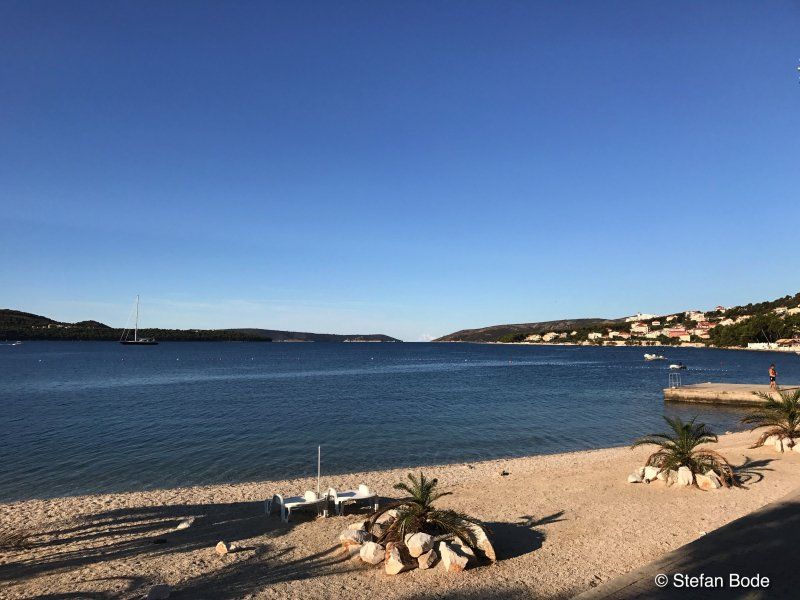
Our first stay was the Autokamp Seget. Goal = arriving on vacation.
Hrvatskih žrtava 121, 21218, Seget Donji, Kroatien
43° 31' 7.7" N 16° 13' 26.4" E
43.5188000 16.2240000
• Head east. Go for 22 m.
• Turn left toward Ulica hrvatskih žrtava. Go for 32 m.
• Turn right onto Ulica hrvatskih žrtava. Go for 460 m.
• Turn right onto Ulica don Petra Špike. Go for 14 m.
• Turn right toward Put akademika Mihe Barada. Go for 17 m.
• Turn right onto Put akademika Mihe Barada. Go for 11 m.
• Turn left onto Ulica hrvatskih žrtava. Go for 79 m.
• Turn right toward Ulica hrvatskih žrtava. Go for 31 m.
• Continue on Put Vlaške. Go for 507 m.
• Turn right and take ramp onto Kralja Tomislava (8) toward Split. Go for 25.4 km.
• Keep left onto Smokovik I (8) toward Dubrovnik/Makarska/Omiš. Go for 116 m.
• Take ramp. Go for 871 m.
• Turn right onto Poljička ulica (410) toward Split. Go for 3.8 km.
• Turn right toward Gat svetog Petra. Go for 167 m.
• Turn right onto Gat svetog Petra. Go for 188 m.
• Take the Split-Stari Grad Ferry. Stay on for 42.1 km.
• Head southeast. Go for 33 m.
• Turn left toward 116. Go for 137 m.
• Turn right onto 116 toward Sućuraj/Jelsa/Vrboska/Stari Grad. Go for 2.8 km.
• Continue on Selca-Dubovica (116). Go for 1.5 km.
• Continue on 116. Go for 2.8 km.
• Continue on Ulica Zaraće (116). Go for 757 m.
• Continue on 116. Go for 2.1 km.
• Continue on Milna (116). Go for 209 m.
• Continue on 116. Go for 2.5 km.
• Continue on Ulica Miće Marchija (116). Go for 2.0 km.
• Turn right onto Ulica Domovinskog rata (116) toward Vira/Hvar. Go for 14 m.
• Continue on Ulica Antifašizma (116). Go for 903 m.
• Continue on 6269. Go for 1.4 km.
• Continue on 6269. Go for 568 m.
• Turn right onto 6269. Go for 839 m.
• Turn right onto Ulica uvala Vira. Go for 377 m.
• Turn left onto Ulica uvala Vira. Go for 287 m.
• Arrive at Ulica uvala Vira. Your destination is on the right.
☍
93,1 km
(2 hrs. 36 min.)
Day
Day
Day
Camping Vira
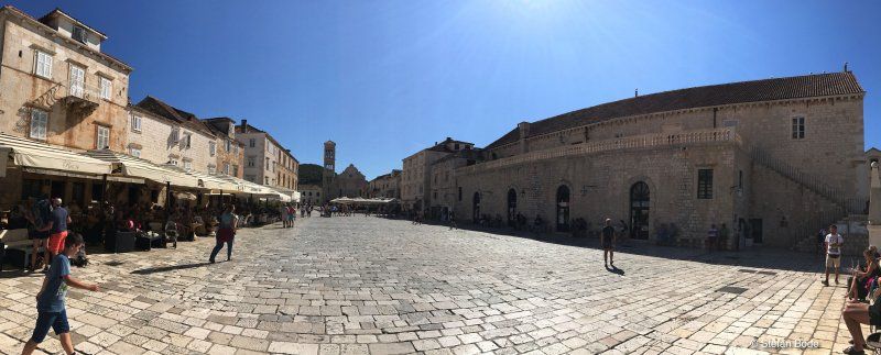
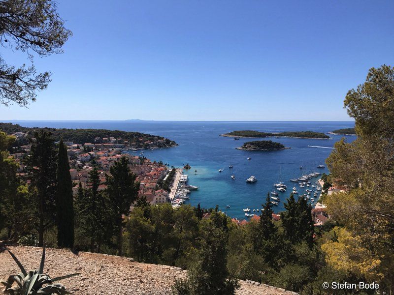
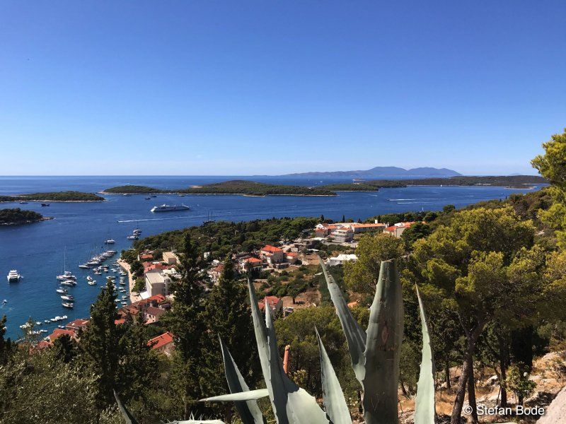
We then continued on the coastal road towards Hvar. In Drvenik we took the ferry to Hvar. There we had to drive through the length of the island to get to the campsite.
From here you could walk through a tunnel to Hvar to visit the city.
Mala vira b.b., 21450, Hvar, Kroatien
43° 11' 27.2" N 16° 25' 46.2" E
43.1909000 16.4295000
• Head northeast on Ulica uvala Vira. Go for 63 m.
• Turn slightly left onto Ulica uvala Vira. Go for 224 m.
• Turn right onto Ulica uvala Vira. Go for 377 m.
• Turn left onto 6269. Go for 839 m.
• Turn left onto 6269. Go for 2.0 km.
• Continue on Ulica Antifašizma (6269). Go for 903 m.
• Turn left onto Ulica Domovinskog rata (116). Go for 14 m.
• Turn left onto Ulica Miće Marchija (116). Go for 2.0 km.
• Continue on 116. Go for 2.5 km.
• Continue on Milna (116). Go for 209 m.
• Continue on 116. Go for 2.1 km.
• Continue on Ulica Zaraće (116). Go for 757 m.
• Continue on 116. Go for 2.8 km.
• Continue on Selca-Dubovica (116). Go for 1.5 km.
• Continue on 116. Go for 3.5 km.
• Continue on Duboka (116) toward Sućuraj. Go for 304 m.
• Continue on 116. Go for 8.9 km.
• Continue on Jelsa (116). Go for 369 m.
• Continue on 116. Go for 4.4 km.
• Continue on Jelsa (116). Go for 7.4 km.
• Continue on 116. Go for 588 m.
• Continue on Poljica (116). Go for 1.1 km.
• Continue on 116. Go for 2.7 km.
• Continue on Zastražišće (116). Go for 3.0 km.
• Continue on 116. Go for 139 m.
• Continue on Zastražišće (116). Go for 484 m.
• Continue on 116. Go for 4.7 km.
• Continue on Gdinj (116) toward Sućuraj. Go for 2.3 km.
• Continue on 116. Go for 450 m.
• Continue on Gdinj (116). Go for 682 m.
• Continue on 116. Go for 1.5 km.
• Continue on Bogomolje (116). Go for 3.0 km.
• Continue on 116. Go for 5.4 km.
• Continue on Uvala Marinja glavica (116). Go for 419 m.
• Continue on 116. Go for 359 m.
• Continue on Selca (116). Go for 559 m.
• Continue on 116. Go for 9.6 km.
• Continue on Put polja (116). Go for 1.4 km.
• Turn right onto Trajektna ulica (116) toward Sućuraj. Go for 635 m.
• Turn right onto Trajektna ulica (116). Go for 109 m.
• Take the Drvenik-Sućuraj Ferry. Stay on for 6.2 km.
• Head northeast on 412. Go for 9 m.
• Turn left onto 412 toward Makarska/Ploče. Go for 73 m.
• Continue on Puntin (412). Go for 14 m.
• Continue on Donja vala (412). Go for 287 m.
• Turn right onto Donja vala (8). Go for 48.5 km.
• Keep left onto 674 toward Dubrovnik/O. Korčula/Ston. Go for 13.4 km.
• Take ramp toward O. Korčula/Orebić/Dančanje/8. Go for 368 m.
• Turn right onto 414 toward O. Korčula/Orebić. Go for 40.8 km.
• Turn left. Go for 195 m.
• Turn left. Go for 35 m.
• Turn right. Go for 91 m.
• Arrive at your destination on the right.
☍
190,2 km
(3 hrs. 44 min.)
Day
Day
Nevio Camping
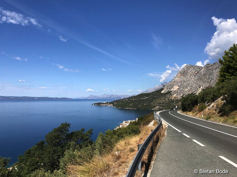
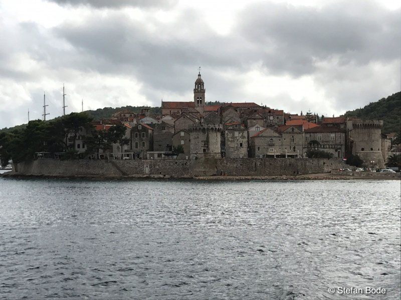
After Hvar the coastal road continued to Sünden to Orebic on the Peljesac peninsula. There was time for a ferry trip to Korcula.
Dubravica 15, 20250, Orebić, Kroatien
42° 58' 53.8" N 17° 11' 57.8" E
42.9816000 17.1994000
• Head east. Go for 91 m.
• Turn left toward 414. Go for 230 m.
• Turn right onto 414. Go for 40.8 km.
• Turn left and take ramp onto 674 toward Split/Ploče. Go for 13.7 km.
• Continue on Jadranska magistrala (8). Go for 21.9 km.
• Turn left onto 425 toward Ploče/A1/Zagreb/Split. Go for 150 m.
• Keep right onto 425 toward Zagreb/Split. Go for 14.7 km.
• Take the exit onto A1 (Čvor Ploče). Go for 214 km.
• Take exit 19 toward Sukošan/Zadar-centar/Zemunik-Zračna luka/Zemunik D./Dugi otok/otok Ugljan/Bibinje/Škabrnja/Smilčić onto 424 (Čvor Zadar istok). Go for 4.4 km.
• Take ramp toward Smilčić/Škabrnja/Zemunik/Obrovac. Go for 632 m.
• Turn left onto 6040 toward Zemunik D. Go for 1.5 km.
• Turn right onto Donji Zemunik ulica I (6011) toward Vir/Nin. Go for 71 m.
• Continue on Donji Zemunik ulica II (6011). Go for 2.4 km.
• Continue on 6011. Go for 64 m.
• Continue on Donji Zemunik ulica II (6011). Go for 235 m.
• Continue on 6011. Go for 410 m.
• Continue on Smoković (6011). Go for 2.4 km.
• Continue on Ulica dr. Franje Tuđmana (6011). Go for 2.7 km.
• Continue on Ulica samostalne satnije Briševo (6011). Go for 4.6 km.
• Take the 2nd exit from roundabout onto 6011. Go for 176 m.
• Continue on Grusi (6011). Go for 103 m.
• Continue on 6011. Go for 354 m.
• Continue on Poljaci (6011). Go for 1.1 km.
• Continue on 6011. Go for 122 m.
• Continue on Žerava-istok (6011). Go for 695 m.
• Continue on Žerava (6011). Go for 786 m.
• Continue on 6011. Go for 2.7 km.
• Continue on Ninski Stanovi ulica I (6011). Go for 480 m.
• Continue on 6011. Go for 37 m.
• Continue on Ninski Stanovi ulica I (6011). Go for 96 m.
• Continue on 6011. Go for 188 m.
• Continue on Ninski Stanovi ulica I (6011). Go for 1.8 km.
• Continue on 6011. Go for 626 m.
• Continue on Kraljičin put (6011). Go for 515 m.
• Take the 2nd exit from roundabout onto Kraljičin put (6011). Go for 380 m.
• Take the 3rd exit from roundabout onto Zadarska ulica toward Zadar/Zaton. Go for 851 m.
• Turn left onto Zadarska ulica (306) toward Zadar/Petrčane/Zaton. Go for 135 m.
• Continue on Zadarska cesta (306). Go for 799 m.
• Turn right toward Dražnikova ulica. Go for 78 m.
• Turn slightly right onto Dražnikova ulica. Go for 721 m.
• Continue on Ulica zatonskih težaka. Go for 22 m.
• Continue on Ulica zatonskih težaka. Go for 50 m.
• Arrive at Ulica zatonskih težaka. Your destination is on the right.
☍
337,5 km
(3 hrs. 32 min.)
Day
Day
Zaton Holiday Resort
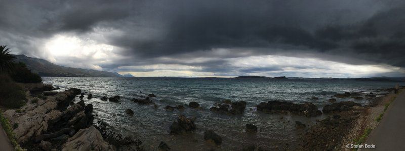
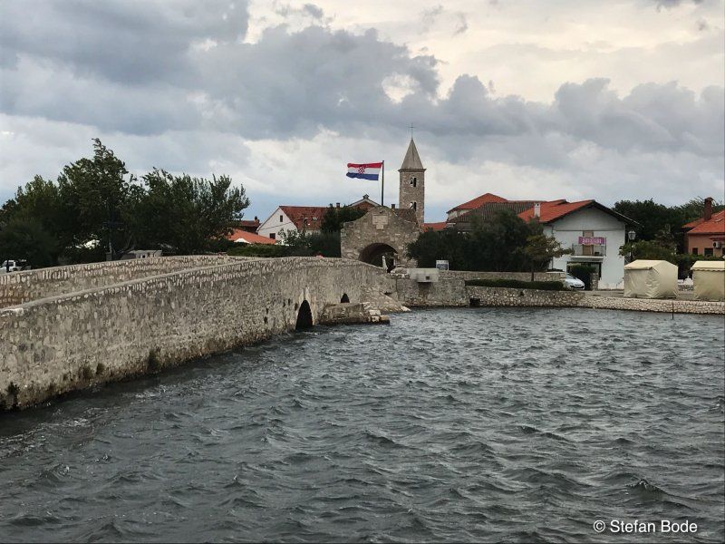
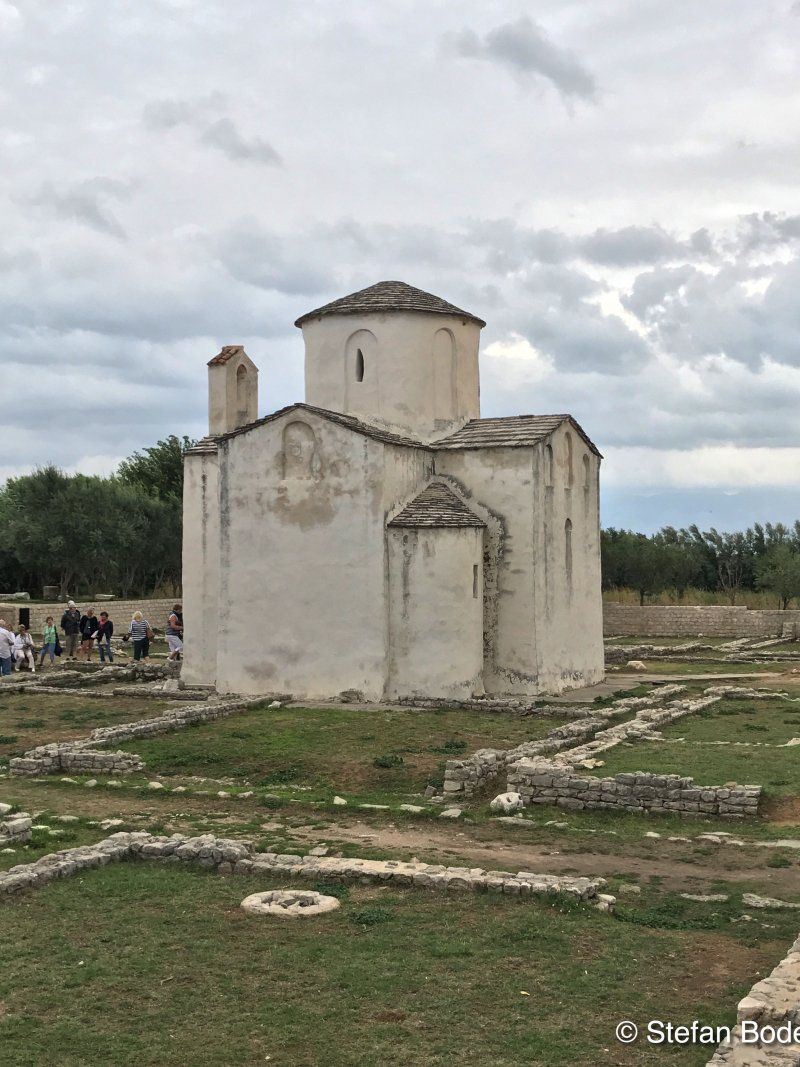
Sightseeing Nin ... and then the rain came. Compulsory stop in Zadar.
Dražnikova 76t, 23232, Nin, Kroatien
44° 13' 41.2" N 15° 10' 9.1" E
44.2281000 15.1692000
• Head north on Ulica zatonskih težaka. Go for 32 m.
• Make a U-Turn onto Ulica zatonskih težaka. Go for 105 m.
• Continue on Dražnikova ulica. Go for 721 m.
• Continue on Dražnikova ulica. Go for 69 m.
• Turn right onto Zadarska cesta (306). Go for 1.4 km.
• Continue on 306. Go for 46 m.
• Continue on Zadarska cesta (306). Go for 1.1 km.
• Continue on 306. Go for 3.1 km.
• Continue on Kožinska cesta (306) toward Zadar/A1. Go for 1.7 km.
• Continue on 306. Go for 516 m.
• Continue on Put Nina (306). Go for 3.0 km.
• Turn right onto Ulica Matije Gupca. Go for 1.1 km.
• Continue on Ulica Antuna Gustava Matoša toward Puntamika. Go for 78 m.
• Turn right onto Ulica Antuna Gustava Matoša. Go for 44 m.
• Arrive at Ulica Antuna Gustava Matoša. Your destination is on the left.
☍
13,0 km
( 16 min.)
Day
Day
Autokamp Borik
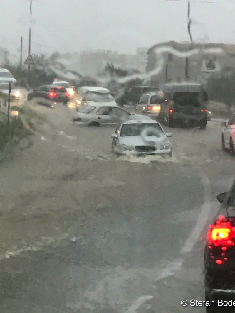
And then came the rain - compulsory stop in Zadar
Majstora Radovana 7, 23000, Zadar, Kroatien
44° 8' 6" N 15° 12' 56.5" E
44.1350000 15.2157000
• Head southeast on Ulica Antuna Gustava Matoša. Go for 44 m.
• Turn left onto Ulica Antuna Gustava Matoša. Go for 78 m.
• Continue on Ulica Matije Gupca. Go for 1.1 km.
• Continue on Ulica Kažimira Zankija (306) toward Zagreb/Rijeka/Šibenik. Go for 4.3 km.
• Turn left onto Ulica 72. bojne Vojne policije (8) toward Zagreb/Rijeka. Go for 15.7 km.
• Turn right and take ramp onto A1 (Autocesta Bosiljevo-Split-Dubrov.) toward Pag/Posedarje/Smilčić/Zagreb/Rijeka. Go for 128 km.
• Take exit 10 toward Senj onto Čvor Žuta lokva. Go for 2.0 km.
• Continue toward Žuta lokva/23. Go for 316 m.
• Take the exit. Go for 1.1 km.
• Turn left onto Žuta lokva (23) toward Rijeka/Otok Rab/Senj. Go for 305 m.
• Turn right onto Žuta lokva (23) toward Rijeka/Senj. Go for 23.4 km.
• Take the 2nd exit from roundabout onto Ulica Filipa Vukasovića (8) toward Rijeka. Go for 22.1 km.
• Continue toward Ulica Zatrep/8. Go for 22 m.
• Take the 2nd exit from roundabout onto Ulica Zatrep (8) toward Rijeka/Otok Krk/Crikvenica. Go for 21.7 km.
• Take ramp toward Otok Lošinj/Otok Cres/Otok Krk. Go for 241 m.
• Take the 3rd exit from roundabout onto 102. Go for 6.1 km.
• Take the 3rd exit from roundabout onto 102 toward Krk/Cres-Lošinj/Njivice. Go for 11.2 km.
• Pass 4 roundabouts and continue on 102. Go for 15.1 km.
• Turn right onto 102. Go for 13.5 km.
• Turn left onto Jurandvor (102). Go for 1.3 km.
• Continue on Zaobilaznica Baška (102). Go for 849 m.
• Continue on Ulica Kricin. Go for 246 m.
• Arrive at Ulica Kricin. Your destination is on the right.
☍
268,6 km
(3 hrs. 20 min.)
Day
Bunculuka Camping Resort
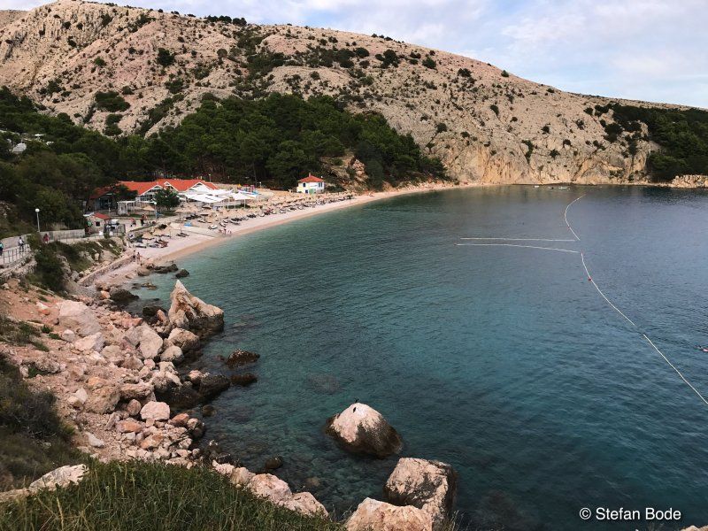
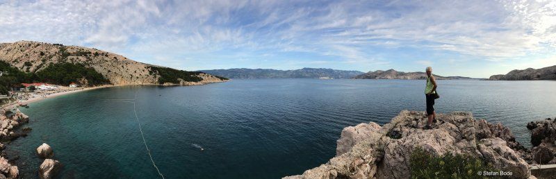
Finally, the sun on Krk
Kricin 30, 51523, Baska, Kroatien
44° 58' 9.1" N 14° 46' 1.2" E
44.9692000 14.7670000
• Head southwest on Ulica Kricin. Go for 246 m.
• Continue on Zaobilaznica Baška (102). Go for 15.6 km.
• Take the 2nd exit from roundabout onto 102 toward Rijeka/Krk. Go for 4.9 km.
• Pass 4 roundabouts and continue on 102. Go for 27.3 km.
• Keep left onto 102 toward Zagreb/Rijeka/Uvala Scott/Kraljevica. Go for 139 m.
• Take the 2nd exit from roundabout onto E65. Go for 674 m.
• Continue on A7. Go for 15.2 km.
• Keep left onto Orehovica (A7) toward Ljubljana/Trieste/Pula/Rijeka zapad. Go for 28.7 km.
• Continue on 202. Go for 256 m.
• Continue on Jelšane (6). Go for 9.9 km.
• Take the 2nd exit from roundabout onto Bazoviška cesta toward Center. Go for 247 m.
• Take the 3rd exit from roundabout onto Bazoviška cesta toward Ljubljana/Postojna. Go for 448 m.
• Take the 1st exit from roundabout onto Gregorčičeva cesta. Go for 624 m.
• Take the 2nd exit from roundabout onto Šercerjeva cesta (404) toward Knežak. Go for 842 m.
• Take the 2nd exit from roundabout onto Šercerjeva cesta (404). Go for 909 m.
• Continue on Topolc (404). Go for 1.5 km.
• Continue on Podstenje (404). Go for 109 m.
• Continue on Topolc (404). Go for 580 m.
• Continue on Šembije (404). Go for 2.8 km.
• Continue on Knežak (404). Go for 3.6 km.
• Continue on Zagorje (404). Go for 2.4 km.
• Continue on Drskovče (404). Go for 897 m.
• Continue on Parje (404). Go for 1.3 km.
• Continue on 404. Go for 798 m.
• Continue on Snežniška cesta (404). Go for 1.2 km.
• Turn right onto Postojnska cesta (6) toward Ljubljana/Postojna. Go for 280 m.
• Take the 3rd exit from roundabout onto Postojnska cesta (6). Go for 8.5 km.
• Take ramp onto A1 toward Ljubljana. Go for 44.3 km.
• Take left exit 36 toward Beljak/Villach/Kranj/Ljubljana-sever onto A2. Go for 71.8 km.
• Continue on Karawankentunnel (A11). Go for 21.1 km.
• Continue on A10 (Tauern Autobahn) toward E55/E66/Salzburg/Villach-Ossiacher See. Go for 79.0 km.
• Take exit 104 toward St. Michael im Lungau. Go for 991 m.
• Continue on Murtal Bundesstraße (B96). Go for 74 m.
• Turn left onto Zederhauser Landesstraße (L212) toward Zederhaus/Muhr/Fell-Oberweißburg/Unterweißburg. Go for 1.2 km.
• Turn left onto Unterweißburg. Go for 110 m.
• Turn left onto Unterweißburg. Go for 807 m.
• Arrive at Unterweißburg. Your destination is on the right.
☍
349,1 km
(4 hrs. 13 min.)
Day
Day
Unterweißburg 7, 5582 Unterweißburg, Österreich
47° 5' 27.6" N 13° 36' 19.1" E
47.0909993 13.6052961
• Head northwest on Unterweißburg. Go for 807 m.
• Turn right onto Unterweißburg. Go for 110 m.
• Turn right onto Zederhauser Landesstraße (L212). Go for 1.2 km.
• Turn right onto Murtal Bundesstraße (B96) toward Salzburg/Villach. Go for 74 m.
• Turn right and take ramp onto A10 (Tauern Autobahn) toward Salzburg. Go for 102 km.
• Take the exit onto A1 (West Autobahn). Go for 3.5 km.
• Continue on A8. Go for 114 km.
• Take exit 95 toward Nürnberg/Stuttgart/Messe/ICM/Flughafen München onto A99. Go for 29.9 km.
• Take exit 13 toward Berlin/Nürnberg/Deggendorf/Flughafen München onto A9. Go for 89.1 km.
• Keep left onto A9. Go for 61.0 km.
• Keep left onto E45 (Autobahnkreuz Nürnberg) toward Frankfurt a.M./Würzburg/Bamberg/Flughafen/A3/Nürnberg-Nord. Go for 2.3 km.
• Continue on A3. Go for 20.2 km.
• Take the exit toward Suhl/Bamberg/Schweinfurt/Erlangen onto A73 (Frankenschnellweg). Go for 47.0 km.
• Take the exit toward Kassel/Schweinfurt/Bamberg Hafen onto A70. Go for 1.9 km.
• Take exit 16 toward Bamberg-Zentrum/P+R/Hallstadt-Ost/Breitengüßbach/Hallstadt onto St2244 (Berliner Ring). Go for 2.2 km.
• Turn left toward Hallstadt. Go for 443 m.
• Take the 2nd exit from roundabout onto Lichtenfelser Straße. Go for 806 m.
• Continue on Marktplatz. Go for 161 m.
• Continue on Bamberger Straße (St2281). Go for 714 m.
• Turn left and take ramp onto A70 toward Schweinfurt/Kassel. Go for 62.2 km.
• Take exit 2 toward Kassel/Fulda onto A7. Go for 112 km.
• Continue on A7. Go for 192 km.
• Take exit 62 toward Hildesheim/Elze/Sarstedt onto B1 (Berliner Straße). Go for 1.7 km.
• Keep right toward B1/B494. Go for 176 m.
• Continue on B6. Go for 500 m.
• Take ramp toward Peine/Hi.-Bavenstedt/Hi.-Drispenstedt/Gewerbegebiet Hi.-Bavenstedt/B494. Go for 186 m.
• Turn left onto Bavenstedter Straße (K107). Go for 287 m.
• Turn right onto Kennedydamm (B494) toward Peine/HI-Drispenstedt. Go for 4.8 km.
• Turn left onto Morgenstern (L467) toward Harsum. Go for 538 m.
• Turn right onto Kaiserstraße (L467). Go for 323 m.
• Turn left onto Breite Straße (L467). Go for 62 m.
• Turn left onto Oststraße. Go for 14 m.
• Turn right onto Hessingsweg. Go for 65 m.
• Arrive at Hessingsweg. Your destination is on the left.
☍
852,4 km
(8 hrs. 7 min.)
Harsum, Deutschland
52° 12' 35.9" N 9° 57' 46.6" E
52.2099738 9.9629420