Some of the most well-known types of cheese in Switzerland and the places where they are made inspired me to take this tour. Peppered with other culinary highlights, we continue. Sights and interesting museums complement the tour.
Day
L'Auberge 154, Saicourt, Schweiz
L'Auberge 154, 2713 Saicourt, Schweiz
47° 15' 42.5" N 7° 10' 7.4" E
47.2618129 7.1687110
• Head toward Le Domaine on L'Auberge. Go for 209 m.
• Turn left onto Route des Genevez. Go for 2.5 km.
• Continue on Route de Bellelay. Go for 547 m.
• Continue on Bas du Village. Go for 166 m.
• Continue on Route de Saignelégier. Go for 139 m.
• Continue on Bout du Village. Go for 1.7 km.
• Continue on Les Vacheries. Go for 1.6 km.
• Turn right toward Le Cernil. Go for 374 m.
• Continue on Le Cernil. Go for 1.7 km.
• Turn right onto Gruère. Go for 1.5 km.
• Continue on La Gruère. Go for 1.3 km.
• Continue on La Theurre. Go for 930 m.
• Continue on Les Cerlatez. Go for 2.7 km.
• Continue on Route de la Gruère. Go for 65 m.
• Take the 2nd exit from roundabout onto Route de la Gruère. Go for 687 m.
• Take the 2nd exit from roundabout onto Place du Vingt-Trois Juin (18). Go for 76 m.
• Take the 1st exit from roundabout onto Place du Vingt-Trois Juin. Go for 32 m.
• Continue on Route de France. Go for 1.1 km.
• Continue on La Nouvelle Deute. Go for 4.0 km.
• Continue on Coin de Muriaux. Go for 498 m.
• Continue on Belfond-Dessus. Go for 1.5 km.
• Turn right onto Route Principale. Go for 702 m.
• Continue on Principale. Go for 244 m.
• Turn right onto Principale. Go for 98 m.
• Continue on Vieux Pont. Go for 534 m.
• Arrive at your destination on the left.
☍
24,8 km
( 26 min.)
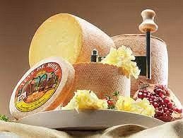
Zur Wiege des Tête-de-Moins, Bellelay (www.tetedemoine.ch/de/)
Tête de Moine (French for "monk's head") is a semi-hard cheese made from untreated cow's milk in the Bernese Jura and Canton of Jura.
Its origins lie in the 12th century in Bellelay Abbey. Since 2001, the designation "Tête de Moine, Fromage de Bellelay" has been registered as a protected designation of origin (Appellation d'Origine Protégée (AOP)). Traditionally, Tête de Moine is not sliced, but scraped very finely. A special tool, the Girolle, has been available since 1982. This usually consists of a round wooden plate with a vertical pin in the middle and a crank. The cylindrical cheese is centered on the pin; before that, however, the rind is cut away from the top of the cheese, which is then vaguely reminiscent of a tonsure, which also gave the cheese its name. With the help of the crank placed on the pin, rosettes can now be made from finely grated cheese. The enlarged surface brings out the flavor particularly well. When scraping, the cheese rind comes off at the edge and crumbles. The scraper got its name from the appearance of the rosettes, which are reminiscent of chanterelles (French girolle).
The Pirouette , in which the cheese is sold together with a disposable Girolle, was developed for beginners and as gifts. When the storage box is unpacked, the saucer folds open and only the Girolle needs to be attached.
Camping Municipal, Goumois, Schweiz
Camping, 2354 Goumois, Schweiz
47° 16' 1.9" N 6° 57' 2.7" E
47.2671841 6.9507452
• Head toward Le Theurez. Go for 106 m.
• Turn slightly left onto Vieux Pont. Go for 428 m.
• Continue on Principale. Go for 98 m.
• Turn left onto Principale. Go for 244 m.
• Continue on Route Principale. Go for 2.0 km.
• Continue on Belfond-Dessus. Go for 529 m.
• Continue on Coin de Muriaux. Go for 3.9 km.
• Continue on La Nouvelle Deute. Go for 565 m.
• Continue on Route de France. Go for 719 m.
• Continue on Place du Vingt-Trois Juin. Go for 22 m.
• Take the 1st exit from roundabout onto Rue Bel-Air (18). Go for 2.8 km.
• Take the 2nd exit from roundabout onto Les Emibois (18). Go for 2.7 km.
• Take the 3rd exit from roundabout onto Rue de la Rauracie (18). Go for 10.0 km.
• Pass 2 roundabouts and continue on 18. Go for 8.7 km.
• Turn left onto Rue du Marais. Go for 170 m.
• Take the 1st exit from roundabout onto Rue Fritz-Courvoisier (18). Go for 294 m.
• Turn left onto Rue de l'Etoile. Go for 80 m.
• Turn right onto Rue de la Chapelle. Go for 240 m.
• Turn left onto Rue de l'Hôtel-de-Ville. Go for 1.4 km.
• Turn right toward Rue de l'Hôtel-de-Ville. Go for 25 m.
• Take the 1st exit from roundabout onto Boulevard de la Liberté (20) toward Besançon/Le Locle/La Chaux-de-Fonds. Go for 739 m.
• Take the 3rd exit from roundabout onto Boulevard de la Liberté. Go for 161 m.
• Continue on Bois-du-Couvent. Go for 223 m.
• Arrive at Bois-du-Couvent. Your destination is on the right.
☍
36,1 km
( 40 min.)
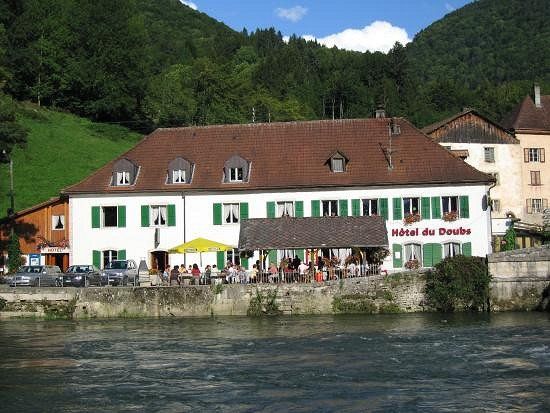
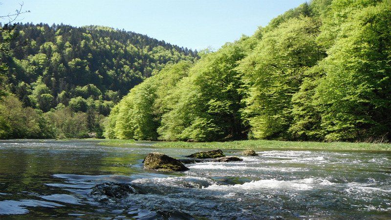
Goumois und die Doubs-Forelle
Goumois is first mentioned in 1177 under the name Gamoensis ecclesia , which was probably derived from the Germanic personal name Godemod . The village was subject to the priory of Lanthenans and passed to the Counts of Mömpelgard (Montbéliard) in 1247. Since the 14th century, Goumois has belonged to the Franquemont dominion, which was conquered by the prince-bishop of Basel in 1474, but was still disputed between the Bishopric of Basel and France until 1780. From 1793 to 1815, Goumois belonged to France and was initially part of the Département du Mont-Terrible, from 1800 linked to the Département Haut-Rhin. Due to the decision of the Congress of Vienna, the district on the right bank of the Doubs came to the canton of Bern in 1815. As a result of a federal referendum on September 24, 1978, Goumois became part of the newly founded canton of Jura on January 1, 1979. After voters approved the merger proposal on June 26, 2007, Goumois, Les Pommerats and Saignelégier merged with effect from January 1, 2009 to form the new municipality of Saignelégier.
On June 20, 1940, around 43,000 soldiers of the French 45th Fortified Army Corps, including 12,500 soldiers of the Polish 2nd Rifle Division, crossed the Doubs near Goumois and were disarmed and interned by the Swiss army.
Day
Camping Bois du Couvent
Bois du Couvent 108, 2300, La-Chaux-de-Fonds, Switzerland
47° 5' 39" N 6° 50' 13.7" E
47.0941600 6.8371300
• Head north on Bois-du-Couvent. Go for 223 m.
• Continue on Boulevard de la Liberté. Go for 112 m.
• Take the 1st exit from roundabout onto Boulevard de la Liberté (20). Go for 740 m.
• Take the 2nd exit from roundabout onto 20 toward Neuchâtel. Go for 15.8 km.
• Take the exit toward Pontarlier/Peseux/Neuchâtel Vauseyon onto Route des Gorges-du-Seyon. Go for 202 m.
• Take the 2nd exit from roundabout onto Rue du Vauseyon (10) toward Bern/Biel/Bienne/Lausanne/Neuchâtel Centre. Go for 67 m.
• Keep right onto Rue du Vauseyon (10). Go for 151 m.
• Keep left toward Neuchâtel-Centre. Go for 26 m.
• Keep right toward Neuchâtel-Centre. Go for 25 m.
• Turn right onto Rue de Maillefer toward Serrières. Go for 770 m.
• Take the 2nd exit from roundabout onto Rue Martenet. Go for 443 m.
• Turn right onto Quai Jeanrenaud (5). Go for 966 m.
• Take the 2nd exit from roundabout onto A5 toward Lausanne. Go for 34.9 km.
• Take exit 24 toward Lausanne/Besançon/Vallorbe onto A1. Go for 6.2 km.
• Take exit 23 toward Besançon/Vallorbe/Orbe onto A9. Go for 16.2 km.
• Take the 2nd exit from roundabout onto Route du Creux (9) toward Vallorbe/Vallée de Joux. Go for 2.6 km.
• Turn right onto Rue du Simplon. Go for 42 m.
• Continue on Rue de l'Ancienne-Poste. Go for 385 m.
• Turn right onto Rue de la Gare. Go for 835 m.
• Continue on Rue des Grottes. Go for 785 m.
• Continue on Le Reposoir. Go for 2.1 km.
• Continue on Le Mont-d'Orzeires. Go for 4.0 km.
• Continue on Rue de la Gare. Go for 354 m.
• Turn right toward Les Epinettes. Go for 111 m.
• Continue on Les Epinettes. Go for 1.2 km.
• Continue on La Colline. Go for 1.2 km.
• Continue on Route du Lieu. Go for 1.8 km.
• Continue on Grand'Rue. Go for 1.5 km.
• Turn left. Go for 42 m.
• Turn right. Go for 541 m.
• Turn left toward Esserts-de-Rive Haut. Go for 690 m.
• Continue on Esserts-de-Rive Haut. Go for 79 m.
• Continue on Esserts-de-Rive Bas. Go for 210 m.
• Continue on Esserts-de-Rive Haut. Go for 417 m.
• Continue on Le Rocheray. Go for 410 m.
• Turn right. Go for 199 m.
• Arrive at your destination on the right.
☍
96,2 km
(1 hrs. 15 min.)
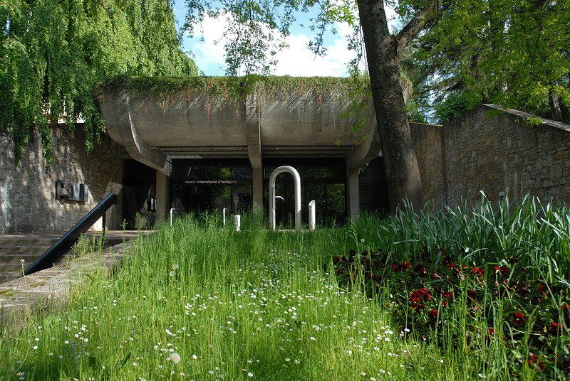
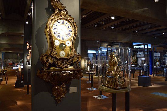
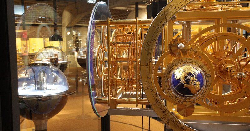
Internationales Uhrenmuseum, La Chaux-de-Fonds (www.j3l.ch/de/P33465/internationales-uhrenmuseum)
The largest museum in the world specializing in watches: 4000 exhibits to visit! From the sundial to magnificent pocket and wall clocks, goldsmith jewelery and scientific techniques to the atomic clock, this unique museum uses 4,000 exceptional exhibits to illustrate the history of time measurement.
Day
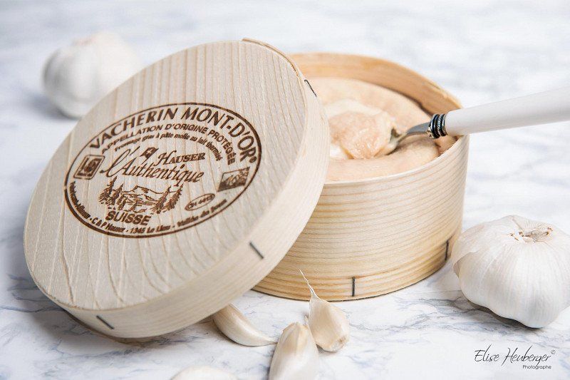
Vacherin Mont d’Or (www.vacherin-montdor.ch)
Vacherin Mont-d'Or AOP is an aromatic soft cheese specialty from the Vallée de Joux. Baked in the oven with garlic and a dash of white wine, it's irresistible. Every year in September, the Vacherin Mont-d'Or festival in Les Charbonnières heralds the season of the winter cheese, recognizable by its typical spruce box.
Vacherin Mont-d'Or AOP is a soft cheese from the Vallée de Joux. It is made from thermized cow's milk and matured for 21 days. Each cheese is individually packed in a spruce box. The Vacherin is made from September to the end of winter, a time when the cows no longer produce enough milk to produce large cheeses. The milk comes from Fleckvieh and Montbéliard cows that graze in the AOP area on alpine meadows at an altitude of over 700 m. The Vacherin Mont-d'Or AOP has been produced by the dairy cooperative in Les Charbonnières since 1865 and has received many awards. A Vacherin Mont-d'Or AOP weighs less than 3 kg and has a maximum diameter of 32 cm. It has been registered as a protected designation of origin AOP since 2003, which guarantees its origin and the production process.
Patrick et Charles Hauser Manufacturers and Affineurs 1345 Le Lieu
Camping du Lac de Joux
Rocheray 37, 1347, Le Sentier, Switzerland
46° 37' 34.5" N 6° 15' 10.1" E
46.6262600 6.2528000
• Head toward Le Rocheray. Go for 199 m.
• Turn left onto Le Rocheray. Go for 410 m.
• Continue on Esserts-de-Rive Haut. Go for 417 m.
• Continue on Esserts-de-Rive Bas. Go for 210 m.
• Continue on Esserts-de-Rive Haut. Go for 79 m.
• Continue straight ahead. Go for 1.2 km.
• Turn left toward Grand'Rue. Go for 42 m.
• Turn right onto Grand'Rue. Go for 3.0 km.
• Continue on Route du Lieu. Go for 1.1 km.
• Continue on La Colline. Go for 309 m.
• Continue on Rue du Mont d'Or. Go for 1.3 km.
• Turn left onto Rue de la Gare. Go for 2.2 km.
• Continue on Le Mont-d'Orzeires. Go for 2.2 km.
• Continue on Le Reposoir. Go for 2.1 km.
• Continue on Rue des Grottes. Go for 785 m.
• Continue on Rue du Faubourg. Go for 835 m.
• Turn slightly right onto Place de la Liberté. Go for 258 m.
• Turn left onto Rue de Pontarlier (9). Go for 2.7 km.
• Take the 2nd exit from roundabout onto Route du Creux (E23) toward Pontarlier. Go for 347 m.
• Continue on Route de Vallorbe (N57). Go for 5.0 km.
• Take the 1st exit from roundabout onto Route des Alpes (N57). Go for 416 m.
• Take the 2nd exit from roundabout onto N57 toward Dijon/Besançon/Pontarlier/Mouthe/Labergement Ste M. Go for 13.0 km.
• Turn sharp right onto Lieu-dit Le Frambourg. Go for 462 m.
• Turn right onto D67 B. Go for 6.9 km.
• Continue on Meudon (10). Go for 6.1 km.
• Pass 2 roundabouts and continue on 10. Go for 4.4 km.
• Take the 1st exit from roundabout onto Rue des Moulins. Go for 272 m.
• Turn left onto Rue des Petits-Clos. Go for 845 m.
• Turn right toward Rue du Temple. Go for 32 m.
• Turn left onto Rue du Temple. Go for 108 m.
• Continue on Rue du Collège. Go for 42 m.
• Continue on Chaux. Go for 862 m.
• Continue on Rue du Collège. Go for 135 m.
• Turn right onto Clos du Terreau. Go for 299 m.
• Turn right onto Rue Jean-Jacques Rousseau. Go for 397 m.
• Arrive at your destination on the right.
☍
58,8 km
(1 hrs. 4 min.)
Day
Le Château, Môtiers, Schweiz
Le Château, 2112 Val-de-Travers, Schweiz
46° 54' 16.5" N 6° 36' 41.4" E
46.9045817 6.6114903
• Head toward Vers Plaine Fin. Go for 359 m.
• Continue on Rue Jean-Jacques Rousseau. Go for 38 m.
• Turn left onto Clos du Terreau. Go for 299 m.
• Turn right onto Rue du Collège. Go for 256 m.
• Continue on Rue Centrale. Go for 1.1 km.
• Continue toward Les Petits-Marais. Go for 315 m.
• Continue on Les Petits-Marais. Go for 465 m.
• Continue on Saint-Gervais. Go for 352 m.
• Turn right onto Rue Pierre-Dubied. Go for 217 m.
• Continue on Chemin de la Nouvelle Censière. Go for 2.5 km.
• Continue on Le Liéchoux. Go for 272 m.
• Continue on Riaux. Go for 241 m.
• Continue on Haut-de-Riaux. Go for 1.7 km.
• Turn left onto Le Rhedoz. Go for 927 m.
• Continue on Grand-Pré Baillod. Go for 2.9 km.
• Turn left. Go for 807 m.
• Turn slightly left. Go for 686 m.
• Turn right. Go for 265 m.
• Arrive at your destination on the right.
☍
13,7 km
( 19 min.)
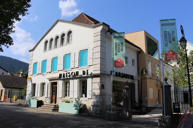
Absinth - Museum (www.maison-absinthe.ch)
Absinthe, also known as absinthe , is one of the wormwood spirits and is an alcoholic drink that is traditionally made from wormwood, anise, fennel, a number of other herbs that vary depending on the recipe, and alcohol.
Most absinthe brands are green, so absinthe is also called "The Green Fairy" (French La fée verte ). The alcohol content is usually between 45 and 89 percent by volume and is therefore assigned to the upper range of spirits. Due to the use of bitter-tasting herbs, particularly wormwood, absinthe is considered a bitter spirit, although it doesn't necessarily taste bitter.
Absinthe was originally produced in the 18th century in the Val de Travers in what is now the Swiss canton of Neuchâtel ( République et Canton de Neuchâtel ) as a medicinal remedy. This spirit, which is traditionally drunk mixed with water, found great popularity in France in the second half of the 19th and early 20th centuries. Famous absinthe drinkers include Charles Baudelaire, Paul Gauguin, Vincent van Gogh, Ernest Hemingway, Edgar Allan Poe, Arthur Rimbaud, Aleister Crowley, Henri de Toulouse-Lautrec and Oscar Wilde.
At the height of its popularity, the drink had a reputation for being addictive and causing serious health problems due to its thujone content. From 1915, the drink was banned in a number of European countries and the USA. Modern studies have not been able to prove harm from absinthe consumption beyond the effects of alcohol; the damage to health found at that time is now attributed to the poor quality of the alcohol and the high quantities of alcohol consumed. Absinthe has been available again in most European countries since 1998. In Switzerland, too, the manufacture and sale of absinthe has been permitted again since 2005.
Day
La Baronne, Travers, Schweiz
La Baronne, Val-de-Travers, Schweiz
46° 55' 40.5" N 6° 42' 52.5" E
46.9279264 6.7145760
• Head northwest. Go for 265 m.
• Turn left. Go for 1.5 km.
• Turn left toward Montagne-Delay. Go for 3.6 km.
• Continue on Montagne-Delay. Go for 77 m.
• Continue on Chez la Gaille. Go for 1.0 km.
• Continue on Grand Pré. Go for 1.5 km.
• Continue on Route de la Montagne. Go for 2.3 km.
• Continue on Route de Montalchez. Go for 180 m.
• Continue on Chemin des Tilles. Go for 176 m.
• Continue on Closelets. Go for 1.4 km.
• Continue on Route de Provence. Go for 215 m.
• Continue on Route de Concise. Go for 2.7 km.
• Continue on La Prise-Gaulaz. Go for 160 m.
• Continue on Route de Provence. Go for 1.9 km.
• Take the 1st exit from roundabout onto Route Cantonale (5). Go for 866 m.
• Pass 5 roundabouts and continue on 5. Go for 5.1 km.
• Turn right. Go for 176 m.
• Take the 2nd exit from roundabout. Go for 155 m.
• Take the 2nd exit from roundabout onto A5 toward Lausanne/Yverdon. Go for 8.5 km.
• Continue on Yverdon toward Bern/Yverdon-Sud. Go for 71 m.
• Take the exit onto A1. Go for 24.9 km.
• Take exit 27 toward Fribourg/A12/Payerne. Go for 1.0 km.
• Take the 1st exit from roundabout toward Lausanne/A12/Fribourg/Z.I. La Boverie. Go for 1.2 km.
• Pass 2 roundabouts. Go for 2.0 km.
• Turn right toward Bern/12/Fribourg/Lausanne. Go for 329 m.
• Keep left toward Bern/Fribourg/A12. Go for 689 m.
• Take the 2nd exit from roundabout toward Fribourg/A12/Prez-Noréaz. Go for 810 m.
• Continue on Le Bochet. Go for 1.0 km.
• Continue on Route de Fribourg. Go for 1.8 km.
• Continue on Impasse de la Villaire. Go for 763 m.
• Continue on Route de Payerne. Go for 1.8 km.
• Continue on Route de Fribourg. Go for 1.9 km.
• Continue on La Maison Rouge. Go for 955 m.
• Continue on Route de Rosé. Go for 808 m.
• Take the 2nd exit from roundabout onto Route de Rosé toward Fribourg/A12. Go for 1.4 km.
• Take the 1st exit from roundabout onto Route de Matran toward E27/A12/Bulle/Romont. Go for 245 m.
• Take the 2nd exit from roundabout onto Route de Matran toward E27/A12/Bulle/Romont. Go for 161 m.
• Continue on Route de la Pala. Go for 403 m.
• Take the 2nd exit from roundabout onto Route de la Pala toward E27/A12/Bulle/Romont/Fribourg. Go for 541 m.
• Take the 3rd exit from roundabout onto Route de Neyruz toward Fribourg/Posieux. Go for 231 m.
• Take ramp onto A12 toward Vevey/Bulle. Go for 18.1 km.
• Take exit 4 toward Bulle/Château-d'Oex/Charmey-Jaun/Gruyères/Le Moléson/Hôpital onto 190. Go for 739 m.
• Take the 2nd exit from roundabout onto 189. Go for 1.0 km.
• Pass 2 roundabouts and continue on 189. Go for 2.9 km.
• Take the 2nd exit from roundabout. Go for 152 m.
• Continue straight ahead. Go for 19 m.
• Take the 1st exit from roundabout. Go for 740 m.
• Continue on Le Chêrvi. Go for 461 m.
• Continue on Route de Pringy. Go for 15 m.
• Continue on Route de Gruyères. Go for 541 m.
• Continue on Planches Jean. Go for 1.3 km.
• Turn left onto Route de Moléson. Go for 138 m.
• Turn right onto Route de la Cité. Go for 405 m.
• Arrive at Route de la Cité. Your destination is on the left.
☍
101,3 km
(1 hrs. 25 min.)
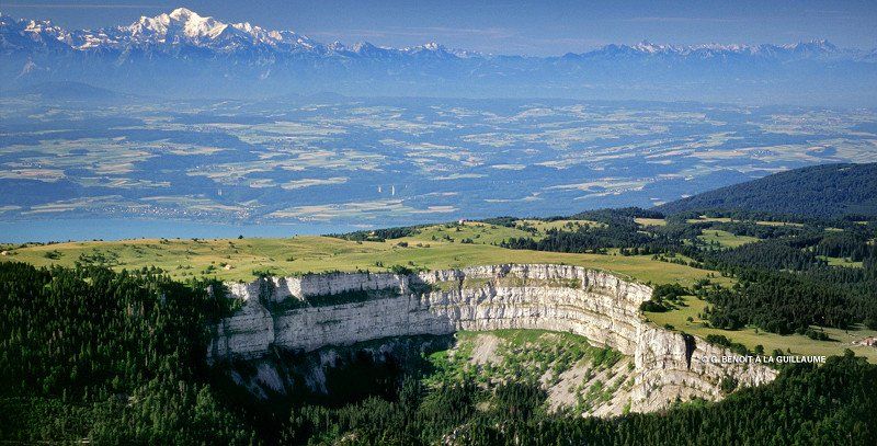
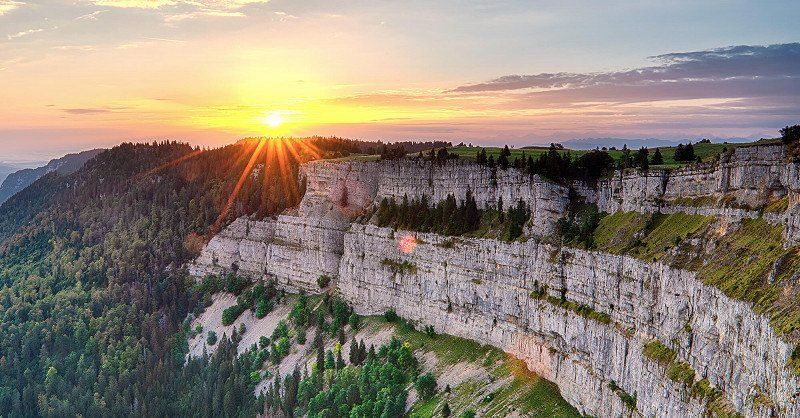
Creux du Van (www.j3l.ch/de/Z10813/creux-du-van)
The Creux du Van is a cirque (cauldron-shaped depressions on mountain slopes below the summit and ridge) in the Swiss Jura on the border between the cantons of Neuchâtel and Vaud in the Val de Travers.
It is about 1200 m wide and 500 m deep. The total length of the rock walls, which drop vertically around 160 meters, is around four kilometers. The area is at Mont Soliat at 1200 to 1450 m above sea level. M. It has been under protection since 1972 and is included in the federal inventory of landscapes and natural monuments of national importance.
The basin was probably formed by erosion after the Würm glaciation. The ground is covered with moraine and landslide material, on which firs and beeches grow. In the middle, below the part of the cauldron that is not wooded at the top, is the Fontaine Froide spring, whose water is a constant 4 °C all year round.
Ibex and chamois live on the rock faces. The last bear was killed in the Creux-du-Van area in 1770. In 1974 and 1975 a pair of lynxes were released. The lynx were wild caught from the Slovakian Carpathians.
The geologically and botanically valuable area is also a popular excursion destination, which is best reached on foot from Noiraigue. The Ferme du Soliat restaurant at the top of the cirque can be reached by car via Couvet or Saint-Aubin-Sauges.
A dry stone wall about two kilometers long was built at the unwooded upper edge of the cauldron, replacing a less aesthetic wire mesh fence. The wall was built free of charge by an international group and is therefore also called the Wall of Friendship . The stone walls are an important habitat for small animals.
The region around the Creux du Van is sparsely populated, since the highlands consist mainly of karst. Therefore, mainly forest and pasture farming is practiced. Many sinkholes can be seen during a hike on the plateau.
Day
Route de la Cité 95, Greyerz, Schweiz
Rte de la Cité 95, 1663 Gruyères, Schweiz
46° 34' 59.4" N 7° 4' 42.4" E
46.5831732 7.0784439
• Head toward Impasse de la Condémine on Route de la Cité. Go for 405 m.
• Turn left onto Route de Moléson. Go for 138 m.
• Turn right onto Route du Pâquier. Go for 1.3 km.
• Continue on Route de Gruyères. Go for 541 m.
• Continue on Route de Pringy. Go for 15 m.
• Continue on Route de Gruyères. Go for 1.2 km.
• Continue straight ahead. Go for 27 m.
• Take the 3rd exit from roundabout. Go for 164 m.
• Take the 1st exit from roundabout onto 189. Go for 1.8 km.
• Pass 2 roundabouts and continue on 189. Go for 2.0 km.
• Take the 2nd exit from roundabout onto 190. Go for 109 m.
• Take left ramp onto A12 toward Lausanne/Vevey. Go for 25.8 km.
• Take the left exit toward Simplon/Gd-St-Bernard/Martigny/Montreux onto A9 (Autoroute du Léman). Go for 48.1 km.
• Take exit 22 toward Gd-St-Bernard/Verbier/Chamonix/Martigny-Expo onto A21 (Grand-Saint-Bernard). Go for 2.1 km.
• Take the exit toward Martigny-Expo/Port-Franc onto 21 (Avenue des Neuvilles). Go for 514 m.
• Take the 3rd exit from roundabout onto Rue du Levant. Go for 584 m.
• Take the 3rd exit from roundabout onto Rue d'Octodure. Go for 124 m.
• Turn left onto Chemin du Vivier. Go for 80 m.
• Turn right onto Chemin du Vivier. Go for 318 m.
• Turn right. Go for 20 m.
• Arrive at your destination.
☍
85,4 km
( 52 min.)
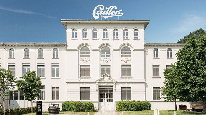
Maison Caillers (www.cailler.ch/de/maison-cailler)
The Cailler family originally came from Daillens near Vevey, where it was first mentioned in the civil register in 1683. From 1920 the Caillers have civil rights in Broc. François-Louis Cailler began industrial chocolate production in Corsier-sur-Vevey in 1819, his sons Auguste and François-Alexandre moved their father's business to Rue des Bosquets in Vevey. The daughter Fanny-Louise married Daniel Peter in 1863, who subsequently also entered the chocolate business. The grandson of the founder, Alexandre-François-Louis Cailler, moved the factory to Broc in Gruyere in 1898. His son Noël inherited it from him. After the merger with Nestlé, the sons Georges and Claude remained on the board of directors, but the Cailler family no longer had any influence on the Cailler brand.
It was founded in 1819 by François-Louis Cailler as a trading company for cocoa powder and chocolate. Shortly thereafter, the first chocolate factory in Switzerland with industrial production was built. In 1898 the move to the new factory in Broc took place. Strong growth followed under the direction of Alexandre-François-Louis Cailler. At the turn of the century, Cailler was the top-selling company in the Swiss chocolate industry. Due to the strong growth and urgently needed investments, the company was converted into a stock corporation in 1900. In 1911, it merged with Peter and Kohler and began exporting abroad. During the First World War, the company fell into crisis as the export markets collapsed. In 1929 the company merged with Nestlé. Many new products came onto the market under the Cailler brand name, and Frigor and Fémina became well-known. There was a threat of closure during the global economic crisis. In 2013, the Maison Cailler had 368,000 visitors from all over the world
Day
Käserei Gruyere (www.lamaisondugruyere.ch/homepage-de/)
Gruyere, often called Gruyère in German-speaking Switzerland, is a semi-hard to hard Swiss hard cheese with a protected designation of origin (see the AOP section there) made from the raw milk of cows. In 2016, 29,136 tons of Gruyère were sold, around 14,900 tons of them in Switzerland. The most important export market is Germany (around 3100 tons). Le Gruyère AOP is produced in Switzerland in a total of 165 cheese dairies and 54 alpine farms (as of 2016). Cheese production in Gruyere can be traced back to 1115. In a document from that year from the first Count of Gruyères, donations of cheese to the Abbey of Rougemont are mentioned. However, it remains unclear what kind of cheese this was.
The use of the name Gruyère to designate a type of cheese that may have been similar to today's Gruyère was first documented in 1602, when the government of Friborg offered fourteen wheels as a gift to delegates at the French embassy. What was meant by this was the cheese produced around the town of Gruyere in Fribourg.
Today the designation Le Gruyère is protected as AOP in Europe. The Le Gruyère Switzerland brand is protected worldwide. The signet of the alphorn player on a cut cheese loaf, which is also protected, belongs to the Swiss Confederation and is protected worldwide, although it is no longer used today. Le Gruyère AOP may only be produced in the cantons of Fribourg, Vaud, Neuchâtel and Jura, the administrative districts of Courtelary, Moutier and La Neuveville, as well as some Bernese municipalities bordering the canton of Fribourg. There is also a historically justified exception for 17 specific cheese dairies in German-speaking Switzerland.
Le Gruyère's AOP is not recognized in the USA or other countries. The name is therefore also used by producers in Eastern France, see Gruyère, here without the grammatical article, in Austria and as "Groviera" by producers in Italy. In the USA, the Roth company also produces a copy of the Gruyere; the large Swiss dairy Emmi AG holds shares in this company. The wheels of cheese, with a diameter of 55 to 65 cm and a thickness of 9.5 to 12 cm, weigh between 25 and 40 kg (average 35 kg). The rind is slightly greasy-brownish, the paste is supple, medium-firm and not very brittle. Fine holes are desirable but not essential. Fine ripening crystallites can be felt on the tongue with a longer-matured Gruyère. The fat content is 49 to 53% in dry matter. The aging (affinage) of Gruyère AOP is an important part of the production process. According to the specifications, a cave-like climate is prescribed for the maturation. Ideally, the humidity is 94-98%. At lower moisture levels, the cheese dries out, and at higher levels, the rind becomes greasy and sticky. The temperature is ideally between 13 and 14 degrees. However, these relatively high temperatures are only possible if the quality of the cheese is very good. Otherwise, rather lower temperatures of 10 to 12 degrees are preferred. The lower the cellar temperature, the harder and more crumbly the cheese will be.
Schloss Greyerz (www.fribourgregion.ch/de/freiburg/aktivitaeten/schloss-greyerz/)
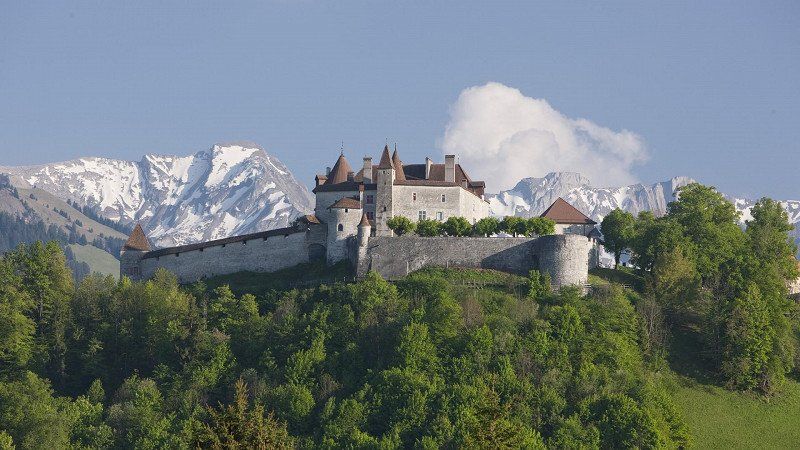
The castle of the former counts towers over today's small town, which used to be the center of the county of Gruyeres in the upper Saane valley. In its remote location, the county enjoyed extensive independence for a long time, but came under Count Rudolf III in 1244. of Gruyeres under the feudal sovereignty of Savoy. The castle was built between 1270 and 1282 in the style of Savoyard fortifications. In the 10th century, the territory of the County of Gruyeres belonged to the Kingdom of Burgundy. The first count of Gruyeres known by name was William I, who took part in the Crusades around 1100 along with numerous young men from Gruyères.
The last owner of the castle, Count Michael von Gruyeres, went bankrupt in 1554. The cities of Bern and Freiburg in Üechtland, which had financed his lavish lifestyle, were able to divide the county among themselves. The castle came to Freiburg and from 1555 to 1814 was the seat of the Freiburg bailiffs.
The castle was then the official residence of the prefect until 1848, before it was sold to the Bovy family from Geneva in 1849[1]. The Bovy invited numerous artists to their castle, including the Geneva painter Barthélemy Menn, as well as Gustave Courbet in 1854 and Camille Corot in the years 1855 to 1861, who painted a hall with Menn and other artists. Auguste Baud-Bovy, himself a member of the owning family, created many of his works in the area around the chateau. Later, through marriage, the castle passed into the possession of the Balland family, who also used it as a summer residence. In 1938 the canton of Friborg bought back the castle and used it as a museum. Since 1993 a foundation has taken care of the preservation of the castle complex and the presentation of the art collections. The castle houses an interesting collection of fantastic art from international artists.
Day
TCS Camping Martigny
Rue du Levant 68, 1920, Martigny, Switzerland
46° 5' 41" N 7° 4' 36" E
46.0947200 7.0766600
• Head toward Chemin du Vivier. Go for 20 m.
• Turn left onto Chemin du Vivier. Go for 318 m.
• Turn left onto Chemin du Vivier. Go for 80 m.
• Turn right onto Rue d'Octodure. Go for 82 m.
• Take the 1st exit from roundabout onto Rue du Levant. Go for 547 m.
• Take the 2nd exit from roundabout onto Avenue des Neuvilles (21). Go for 226 m.
• Take ramp onto A21 toward Lausanne/Simplon. Go for 2.3 km.
• Take exit 22 toward Simplon/Sion onto A9 (Autoroute du Rhône). Go for 26.3 km.
• Take exit 27 toward Sion-Est/Val d'Hérens/Savièse/Ayent. Go for 393 m.
• Take the 3rd exit from roundabout onto Route d'Hérens. Go for 366 m.
• Turn right onto Route d'Hérens. Go for 566 m.
• Turn right and take ramp onto Route d'Italie (9). Go for 3.3 km.
• Take the 2nd exit from roundabout onto Route d'Italie (9). Go for 1.3 km.
• Turn left onto Rue du Lac. Go for 63 m.
• Turn right onto Rue du Lac. Go for 48 m.
• Arrive at Rue du Lac. Your destination is on the right.
☍
35,9 km
( 23 min.)
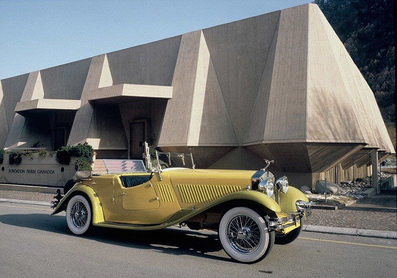
Fondation Gianadda (www.gianadda.ch)
In 1976, Léonard Gianadda, engineer, journalist, artist and internationally renowned patron of the arts, found the remains of a Roman temple on a site on which he was to build a house. Since his younger brother Pierre died in a plane crash when he was only 25, Léonard created a cultural foundation and named it Pierre Gianadda in memory of his brother.
Léonard Gianadda acquired the site and had a concrete building of modern architecture erected according to his own design right above the site where the remains of the temple were excavated.
The foundation has an annual budget of around 8 million Swiss francs, of which the municipality of Martigny contributes more than 545,000 Swiss francs. Around 60 employees are employed. Since the opening of the museums, more than 6.7 million visitors from all over the world have been welcomed (as of 2006). The main sponsors are the municipality of Martigny, the canton of Valais, Credit Suisse, UBS and Loterie Romand. The foundation's partners include Fondation Barry, the St. Bernhard Tunnel, RailAway and the Palais Lumière in Evian. The large new building serves as an entrance building and exhibition hall. It houses three permanent exhibitions: the Gallo-Roman Museum on the site's early history, the ten most beautiful paintings from the collection of Evelyn and Louis Franck, and a small vintage car collection of 50 cars from the years 1897 to 1939, including rare exhibits from Swiss car manufacturers .
The large central room of the main building is used for art exhibitions that change several times a year, primarily private collections and rare exhibits, and for concerts.
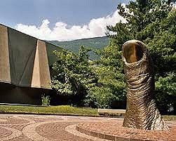
On the sidewalk in front of the main building, a path of fame was laid out, on the slabs of which handprints, footprints or signatures of famous guests are immortalized.
Day
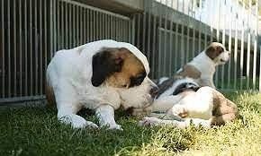
Die Bernhardiner-Hunde im Barryland (www.barryland.ch/de)
The Barryland - Musée et Chiens du Saint-Bernard is a museum in Martigny dedicated to the history and breeding of Saint Bernards.
In 2004, the Order of Canons of the Great St. Bernhard announced that it was no longer able to continue to look after the St. Bernard breed at its hospice due to a lack of sufficient membership. This would have meant the end of the "Vom Großer Sankt Bernhard" breeding line. The "Barry du Grand-Saint-Bernard" foundation then became active and took over the breeding and maintenance of the kennel du Grand St. Bernard (from the Great St. Bernard). Thanks to another endowment by the de Watteville couple, a St. Bernard museum was set up in the former armory in Martigny.
On the first floor, the museum shows exhibits on the old Canterbury-Rome pilgrimage route, which led through the Aosta Valley and required a crossing over the pass. From about the 17th century St. Bernard dogs were kept at the hospice and helped the canons to track down missing pilgrims who had not arrived at their destination because of avalanches or bad weather. This work of the canons and their dogs is shown in the museum e.g. illustrated by a film.
From the 19th century, numerous legends arose about the dogs of the Great St. Bernhard. Numerous exhibits in the museum document how they were portrayed in literature, art and advertising. Changing exhibitions on various themes can be seen on the second floor. The ground floor, including the outdoor enclosures, is reserved for dog breeding and keeping.
Kulinarium Wallis
The best Valais wines (www.vinum.eu)
Valais Raclette (www.raclette-du-valais.ch)
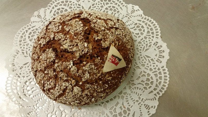
Valais rye bread (www.paindeseiglevalaisan.ch)
Valais dried meat (www.trockenfleischwallis.ch)
Day
Rue des Rocailles 2, Saint-Léonard, Schweiz
Rue des Rocailles 2, 1958 Saint-Léonard, Schweiz
46° 15' 19" N 7° 25' 36.3" E
46.2552892 7.4267528
• Head south on Rue du Lac. Go for 48 m.
• Turn left onto Rue du Lac. Go for 63 m.
• Turn left onto Route du Simplon (9). Go for 7.2 km.
• Take the 2nd exit from roundabout. Go for 240 m.
• Take the 2nd exit from roundabout onto Route d'Écossia. Go for 246 m.
• Take the 1st exit from roundabout onto A9 (Autoroute du Rhône) toward Simplon/Brig. Go for 4.2 km.
• Continue on E62. Go for 6.7 km.
• Pass 3 roundabouts and continue on Kantonsstrasse (E62). Go for 1.1 km.
• Take the 3rd exit from Kreisel Roschätte roundabout onto Kantonsstrasse (E62) toward Simplon/Brig. Go for 917 m.
• Continue on A9. Go for 5.7 km.
• Take the exit. Go for 395 m.
• Take the 2nd exit from Kreisel Tenne roundabout onto Kantonsstrasse (E62) toward Simplon/Brig/Lötschberg/Gampel/Steg. Go for 788 m.
• Pass 2 roundabouts and continue on Kantonsstrasse (E62). Go for 3.4 km.
• Take the 1st exit from Kreisel Turtig West roundabout onto Grossibrigga Gesch toward Raron/Niedergesteln. Go for 827 m.
• Take the 1st exit from Kreisel Gesch roundabout onto Brückenmoosstrasse. Go for 661 m.
• Turn slightly left onto Theaterstrasse. Go for 84 m.
• Turn slightly left onto Theaterstrasse. Go for 109 m.
• Turn right onto Kirchstrasse. Go for 57 m.
• Turn left onto Haltjinen. Go for 27 m.
• Arrive at Haltjinen. Your destination is on the right.
☍
32,7 km
( 28 min.)
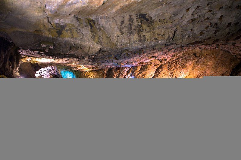
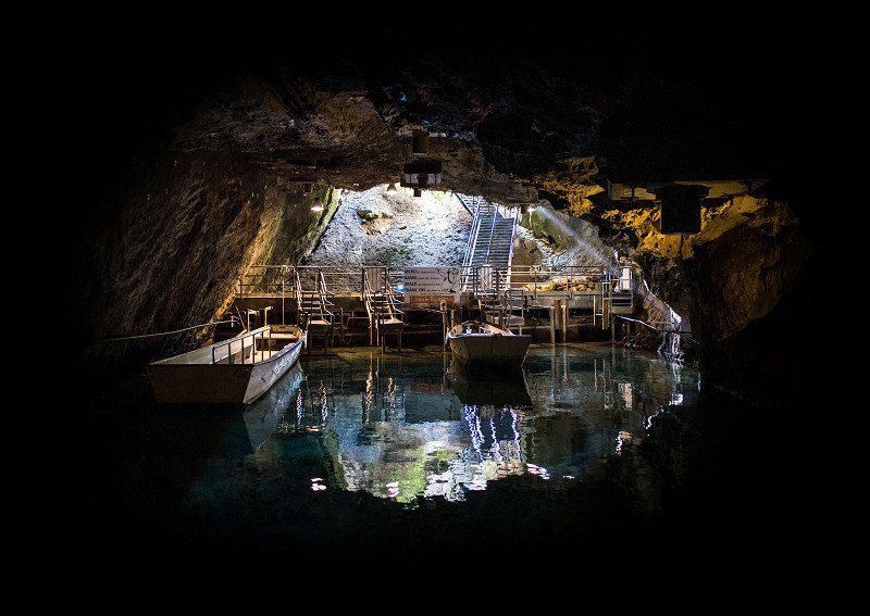
Längster Unterirdischer See Europas (www.lac-souterrain.com/de)
The Lac Souterrain de Saint-Léonard (English: underground lake of Saint-Léonard ) is the largest known natural underground lake in Europe with a surface area of 6,000 m². The entrance to the cave is at the foot of the vineyards in the commune of Saint-Léonard, between Sion and Sierre. The cave is visited by an average of 100,000 visitors a year. With an area of 6,200 m², the Seegrotte in Hinterbrühl in Lower Austria, which is divided into longitudinal and transverse tunnels, is slightly larger. However, this was caused by a sudden inrush of water in the course of a blast for the underground mining of gypsum, so it was created artificially. In addition, the water level is lowered there by continuous pumping.
The cave has long been known to the inhabitants of Saint-Léonard. The cave was first explored in 1943 by the Swiss speleologist Jean-Jacques Pittard, who was accompanied by Jacques Della Santa. When the cave was discovered, the water level was several meters higher than today and almost reached the ceiling. On January 25, 1946, an earthquake with a magnitude of 5.5 to 6 on the Richter scale occurred around Sierre. The earthquake changed the hydrological conditions of the cave and its surroundings, which led to the lowering of the lake level. The cave was made accessible to visitors by two locals as early as 1949. Boat trips on the lake have been offered ever since. In the winter of 2000, a two-ton boulder fell from the ceiling, and the cave was then closed by the authorities. In the course of extensive renovation work costing over 2.5 million Swiss francs, the cave ceiling was secured by installing several thousand large and small rock bolts. In 2003 the cave was reopened to visitors. Bats are the only larger animals naturally found in the cave. Only trout that have been settled by the shipping company and are fed regularly live in the lake.
Kirchweg 10, Raron, Schweiz
Kirchweg 10, 3942 Raron, Schweiz
46° 18' 39" N 7° 48' 7.9" E
46.3108388 7.8021915
• Head south on Haltjinen. Go for 27 m.
• Turn right onto Kirchstrasse. Go for 57 m.
• Turn left onto Theaterstrasse. Go for 193 m.
• Turn left onto Bahnhofstrasse. Go for 421 m.
• Turn left onto Bahnhofstrasse. Go for 255 m.
• Take the 4th exit from roundabout onto Kantonsstrasse (E62) toward Brig. Go for 4.7 km.
• Take the 1st exit from roundabout onto Kantonsstrasse (E62) toward Simplon/Brig-Visp/Furka. Go for 527 m.
• Continue toward Kantonsstrasse/E62. Go for 44 m.
• Take the 1st exit from Bockbart roundabout onto Kantonsstrasse (E62) toward Zermatt/Saas-Fee/Grächen/Visp. Go for 1.1 km.
• Pass 5 roundabouts and continue on Kantonsstrasse (E62). Go for 4.0 km.
• Take the 2nd exit from roundabout onto A9 toward Simplon/Brig. Go for 3.0 km.
• Keep left onto A9 toward Brig-Glis/Furka/Grimsel/Nufenen/Simplon/19. Go for 234 m.
• Take the 3rd exit from roundabout onto Überlandstrasse (19) toward Furka/Grimsel/Nufenen/Brig/Naters/Simplon. Go for 1.4 km.
• Keep left onto 19 toward Furka/Grimsel/Nufenen/Simplon/Naters. Go for 3.5 km.
• Pass 4 roundabouts and continue on Furkastrasse (19). Go for 36.9 km.
• Keep left onto Furkastrasse (19) toward Furka/Grimsel/Oberwald. Go for 35.3 km.
• Take the 3rd exit from roundabout onto Gotthardstrasse (2/19) toward Oberalppass/Andermatt. Go for 3.5 km.
• Take the 1st exit from roundabout onto Gotthardstrasse toward Oberalppass/Andermatt. Go for 789 m.
• Take the 2nd exit from roundabout onto Oberalpstrasse (19) toward Oberalppass/Chur. Go for 31.5 km.
• Turn left onto Via Sursilvana (19). Go for 220 m.
• Arrive at Via Sursilvana (19). Your destination is on the left.
☍
127,5 km
(2 hrs. 18 min.)
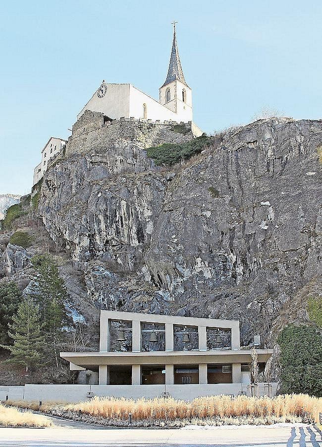
Felsenkirche Raron
The Felsenkirche St. Michael is an underground church in Raron that was inaugurated in 1974. It is located directly below the early 16th century mountain church. With 500 seats, it is the largest church of modern times, which is located entirely inside the rock.
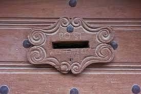
Altester Briefkasten der Schweiz
The oldest post box in Switzerland can be found on the door of the Maxenhaus . It dates back to the Napoleonic era, when Valais was part of the French Empire.
Rainer Maria Rilke
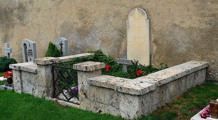
Rainer Maria Rilke ( born December 4, 1875 in Prague, Austria-Hungary; † December 29, 1926 in the Sanatorium Valmont near Montreux, Switzerland; actually: René Karl Wilhelm Johann Josef Maria Rilke ) was an Austrian poet of German and French language. With his accomplished poetry in the New Poems , influenced by the visual arts, he is considered one of the most important poets of modern literature.
A number of stories, a novel and essays on art and culture as well as numerous translations of literature and poetry are known from Rilke's work. His extensive correspondence is considered an important part of his literary work. The poet died on December 29, 1926 and was buried on January 2, 1927 - according to his wishes - near his last place of residence in the mountain cemetery of Raron.
Passo della Novena, Bedretto, Schweiz
Nufenenpass, 6781 Bedretto, Schweiz
46° 28' 33" N 8° 23' 17" E
46.4758333 8.3880556
• Head toward Via Sogn Sigisbert on Via Sursilvana (19). Go for 11.8 km.
• Turn right. Go for 132 m.
• Turn left toward Via Campadi. Go for 92 m.
• Turn right onto Via Campadi. Go for 96 m.
• Arrive at Via Campadi. Your destination is on the right.
☍
12,1 km
( 11 min.)
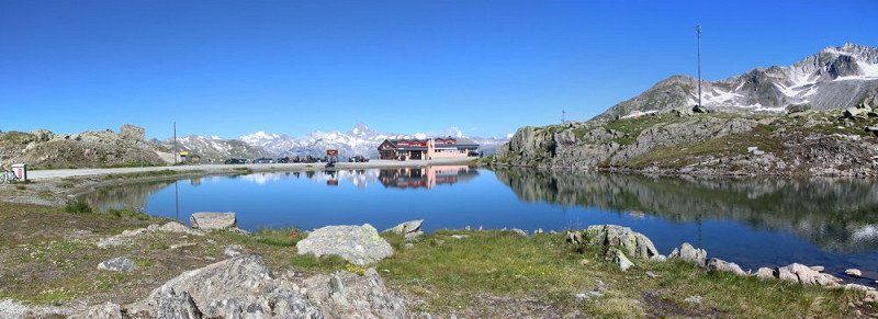
Nufenenpass
The Nufenenpass (Italian Passo della Novena) is a 2439 m above sea level. M. high mountain pass in Switzerland, connecting the cantons of Valais in the west and Ticino in the east, as well as separating the Gotthard group in the north from the Leone group in the south. The Vier-Quellen-Weg runs over the saddle point, but the pass road is a little further north and higher. The pass road, built from 1964 and opened on September 5, 1969, leads from Ulrichen over the 2478 m above sea level. M. located pass in the Bedrettotal and on to Airolo. This pass road is the highest pass road that lies entirely within Switzerland. East of the pass and the canton border from Valais to Ticino, the road climbs slightly again and reaches a peak of 2480 m above sea level. M
The Ticino River has its source east of the Nufenen Pass. From the top of the pass there is a wide view of the Bernese Alps with the Finsteraarhorn to the west, and the Gries Glacier and the Nufenenstock to the south-west.
In the early morning you can see marmots and ibex in the immediate vicinity.
Day
Kloster Disentis, Disentis, Schweiz
7180 Disentis, Schweiz
46° 42' 24.7" N 8° 51' 23.7" E
46.7068677 8.8565962
• Head north on Via Campadi. Go for 96 m.
• Turn left. Go for 92 m.
• Turn right toward Via Principala/19. Go for 132 m.
• Turn right onto Via Principala (19). Go for 16.8 km.
• Pass 3 roundabouts and continue on Stradun Cantunal (19). Go for 22.1 km.
• Take ramp onto A13 toward Chur. Go for 33.0 km.
• Take exit 11 toward St. Gallen/St. Margrethen/München/Feldkirch/Vaduz onto A13. Go for 16.4 km.
• Take exit 8 toward Buchs/Grabs/Spital onto 16. Go for 1.2 km.
• Keep left onto 16 toward Buchs/Grabs. Go for 41 m.
• Take the 1st exit from roundabout onto Fuchsbühelstrasse. Go for 1.4 km.
• Continue on Güterstrasse. Go for 130 m.
• Continue on Langäulistrasse. Go for 696 m.
• Take the 2nd exit from roundabout onto Sankt Gallerstrasse (13). Go for 618 m.
• Take the 2nd exit from roundabout onto Sankt Gallerstrasse (13/16). Go for 330 m.
• Turn right toward Marktplatz. Go for 40 m.
• Continue on Marktplatz. Go for 84 m.
• Continue on Marktweg. Go for 78 m.
• Arrive at Marktweg. Your destination is on the left.
☍
93,4 km
(1 hrs. 4 min.)
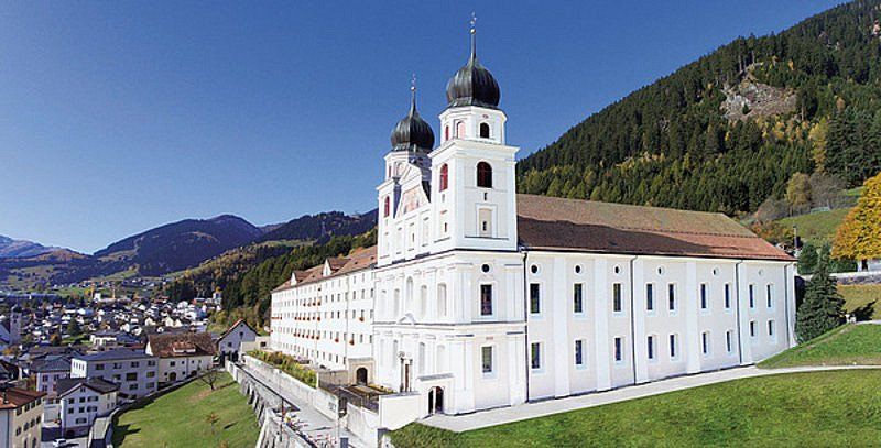
Kloster Disentis
Disentis Monastery is a Benedictine abbey. The abbey was founded around the year 700, bears the name of Saint Martin and presents itself today in the structural condition of the late 17th century. The two-tower church was built between 1696 and 1712 in the Vorarlberg Baroque style and corresponds to the Vorarlberg cathedral scheme. Disentis Monastery belongs to the Swiss Benedictine Congregation.
The museum in the north wing of the convent building shows an art and cultural history collection from the Middle Ages. Thanks to its high school, the monastery is still an important educational center in the region. It can no longer be clearly dated when the Frankish monk Sigisbert settled in the «Desertina». He was joined by the Rhaetian Placidus, a powerful owner of the region. However, since the ruler, President Victor in Chur, saw the special position of Churraetia, which had been preserved until then, in jeopardy, he had Placidus murdered. Tradition stylized the murder as a beheading and subsequently called Placidus a martyr and Sigisbert a confessor (cephalophoric legend). By the year 700 at the latest, a monastery was built around her grave, headed by Abbot Ursicin. The monks adopted the Rule of St. Benedict.
The monastery was first mentioned in a document in 765 in the will of Bishop Tello of Chur. 940 Saracens destroyed the monastery. As the guardian of the Lukmanier Pass, Disentis became important for the imperial interests in Italy. Otto I and Frederick I Barbarossa climbed the pass on their way south. During this time, the monastic state was created, which reached a size of 720 km².
In 1020 Emperor Heinrich II transferred the abbey to the Episcopal Church of Brixen. However, the suzerainty of Brixen remained controversial and ended with the restoration of monastic immunity by the same ruler in 1074.
In 1395 the Prince Abbot of Disentis was a co-founder of the Gray League. During the Reformation the monastery came to the edge of its existence. Gradually the religious and spiritual renewal, which found its striking expression in the baroque monastery building, succeeded.
During the Second Coalition War in the spring of 1799, French troops plundered the monastery. On May 1, 1799, the locals rebelled against the French army. In response, the abbey and village were set on fire on May 6th. After the abbey had already lost its possessions in Valtellina, it was left with "rubble and debt". Reconstruction was slow and was hampered by another fire in 1846. The canton of Graubünden also placed the impoverished monastery under state control: the cantonal monastery law of 1861 largely prevented the admission of novices and the already impoverished Disentis monastery threatened to collapse altogether.
A rethink came in 1880 after a change in mood among the people and in the government. The driving forces behind it were the Disentiser editor Placi Condrau, the young Trunser politician Caspar Decurtins and the Maienfelder Theophil von Sprecher. With the help of the Swiss Benedictine Congregation, especially the Muri-Gries Abbey, the monastery was saved from extinction and flourished again in the 20th century.
Camping Trun
Via Campadi 2, 7166, Trun, Switzerland
46° 44' 27.9" N 8° 59' 39.2" E
46.7410700 8.9942300
• Head toward Moosweg on Marktweg. Go for 78 m.
• Turn right onto Marktplatz. Go for 46 m.
• Continue toward Sankt Gallerstrasse/13/16. Go for 54 m.
• Turn left onto Sankt Gallerstrasse (13/16). Go for 342 m.
• Take the 2nd exit from roundabout onto Städtli (16). Go for 4.7 km.
• Turn slightly left onto Hof (16). Go for 8.1 km.
• Arrive at Hauptstrasse (16). Your destination is on the left.
☍
13,4 km
( 15 min.)
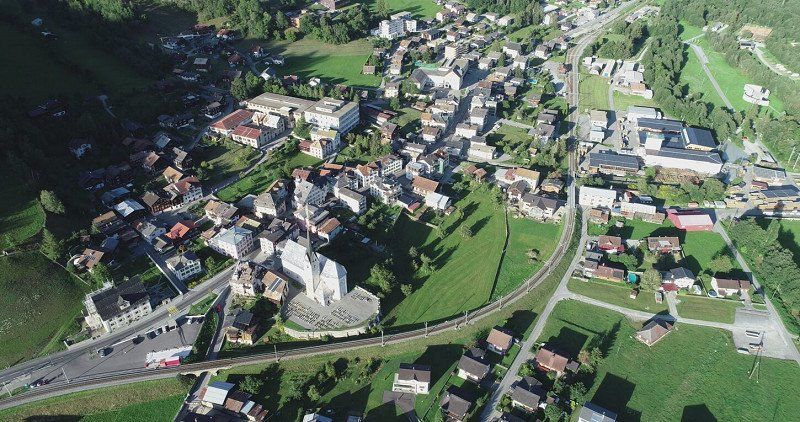
Trun
In 1424, Trun was the place where the Gray League was founded, until 1798 it was the court and until 1814 its meeting place. Since 1701 there has been a courtyard of honor of the Gray Union next to the above-mentioned Caplutta Sontga Onna chapel. The Sursilvan Museum is housed in the former monastery courtyard of La Cuort, where the Bundestag of the Gray League was held from 1428. Among other things, part of the old trunk of the maple tree under which the Gray League was founded in 1424, as well as some works of art by the painter Alois Carigiet, are on display in what was then the Gray League meeting room.
The "TRUNS" brand from Fabrica da ponn (cloth factory, original Swiss military blankets) was present throughout Switzerland from 1912 and the Trunser trousers were the trademark of "every real Bündner". In its heyday, the company built a new factory in 1960/61 and employed 800 people. In 1993 the company ran out of money. 100 jobs could be preserved through a new start with a guarantee from the community. In 1999, the company was again in crisis and introduced short-time work - "the fourth or fifth time in 30 years". A year earlier, the unprofitable production of uniforms had been abandoned. Two years later, the factory finally closed its doors.
Day
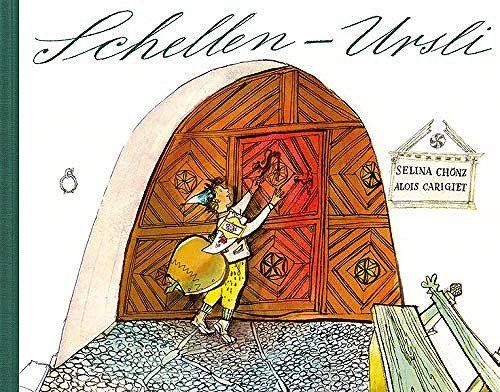
Schellen-Ursli (www.museum-trun.ch)
Schellen-Ursli, in the original Rhaeto-Romanic Uorsin , is a children's story by the author Selina Chönz and the artist Alois Carigiet. It is one of the best-known picture books in Switzerland.
The history
"High up in the mountains, far from here, there lives a little boy like you," the story begins. She plays in Guarda, in the Engadin. It is about the custom of Chalandamarz , which is performed annually on March 1st. Tradition has it that in spring winter is driven out with the loud ringing of the Engadin children's bells.
The protagonist Ursli only received a small bell for the Chalandamarz. He is teased by the other village boys because of this and does not want to accept that he is supposed to go with the parade the following day. He remembers the big cowbell that hangs in the early summer alpine hut in Maiensäss. He sets off on the dangerous path through the deep snow up to the hut. Meanwhile the parents are worried, when it gets dark the whole village is looking for little Ursli; but he arrived happily in the snow-covered Maiensäss. When Ursli turns up at home the next day with the big bell, the relief is great. Now that Ursli is bringing the biggest bell, he is allowed to lead the parade.
The original pictures by Alois Carigiet are in the Trun Valley Museum.
Camping Werdenberg, Marktplatz, Buchs, Schweiz
Marktpl., 9470 Buchs, Schweiz
47° 9' 56.8" N 9° 27' 54.9" E
47.1657658 9.4652522
• Head toward Müsli on Hauptstrasse (16). Go for 12.4 km.
• Turn left and take ramp onto A13 toward St. Gallen/St. Margrethen. Go for 12.1 km.
• Take exit 5 toward Oberriet/Rüthi/Meiningen. Go for 363 m.
• Turn left onto Rheinstrasse (434) toward Oberriet/Rüthi. Go for 828 m.
• Take the 1st exit from roundabout onto Staatsstrasse (13) toward Appenzell/Altstätten. Go for 1.6 km.
• Turn left onto Eichbergstrasse toward Eichberg/Kobelwies/Hub/Hard. Go for 3.0 km.
• Turn right onto Kobelwiesstrasse. Go for 721 m.
• Continue on Eichbergstrasse. Go for 146 m.
• Turn left onto Härdlistrasse. Go for 849 m.
• Continue on Hölzlisbergstrasse. Go for 4.5 km.
• Continue on Eichbergstrasse. Go for 1.8 km.
• Turn right onto Eggerstandenstrasse. Go for 2.8 km.
• Turn right onto Hirschbergstrasse. Go for 340 m.
• Take the 2nd exit from roundabout onto 448. Go for 565 m.
• Pass 2 roundabouts and continue on Entlastungsstrasse (448). Go for 2.5 km.
• Turn right onto Lankstrasse. Go for 742 m.
• Turn left onto Lankstrasse. Go for 58 m.
• Arrive at Lankstrasse. Your destination is on the left.
☍
45,4 km
( 43 min.)
Day
Werdenberg (http://werdenberg.ch/entdecken/ausflugsziele-im-tal/tagesausfluege/?L=0)
experience history. Discover the hidden. Experience pleasure - gem Werdenberg.
The town and castle of Werdenberg look back on 800 years of history. Werdenberg is one of the few surviving urban wooden settlements from the Middle Ages in Europe and is part of the inventory of sites of national importance that are worthy of protection.
Two museums provide insights into the development history of the castle and show how the people in the town lived. The bistro in the castle courtyard invites you to enjoy. In addition to the impressive architecture, the picturesque town of Werdenberg offers many places where local handicrafts can be admired and purchased.
Schwanzweid 621, Wildhaus, Schweiz
Schwanzweid 621, 9658 Wildhaus, Schweiz
47° 12' 2.3" N 9° 21' 36.8" E
47.2006502 9.3602225
Day
Wildhaus
A dense network of hiking trails, including the multi-day Toggenburg Höhenweg over 87 kilometers from Wildhaus to Wil and shorter themed trails such as the Klangweg, Thurweg, Chnobelweg or a Legends Trail encourage you to discover Toggenburg on foot. A barefoot tour on the moor nature trail around the Rietbach high moor near Krummenau with rare plants is balm for body and soul. The hilly topography also attracts mountain bikers. There are 20 signposted routes for them, between 13 and 44 kilometers long. Numerous mountain lakes (Gräppelensee, Schönenbodensee, Schwendiseen) invite you to swim.
Day
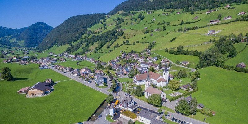
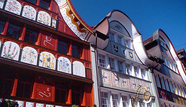
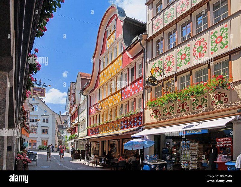
Lankstrasse 3, Appenzell, Schweiz
Lankstrasse 3, 9050 Appenzell, Schweiz
47° 20' 45.2" N 9° 23' 38.5" E
47.3458848 9.3940410
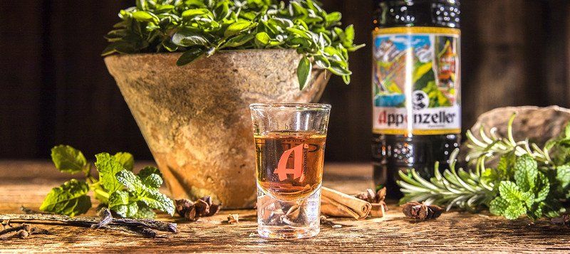
Kulinarium Appenzell
Appenzeller Alpenbitter & Gin (www.appenzeller.com)
Locher beer brewery (www.appenzellerbier.ch)
Säntis Malt Whiskey (www.saentismalt.com)
Sutter cheese (www.sutterkaese.ch)
Dairy products from the farm (www.hofkaese.ch)