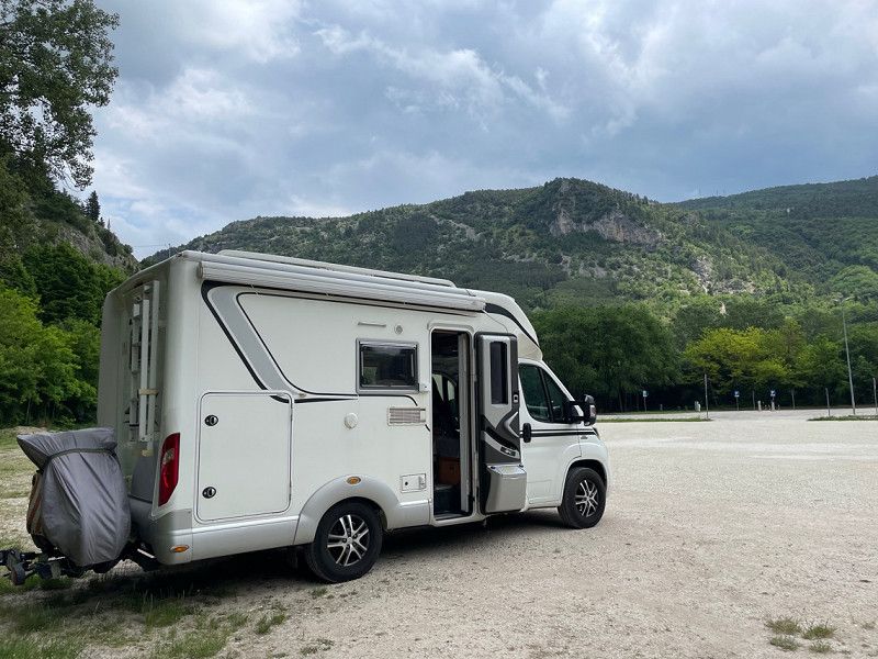
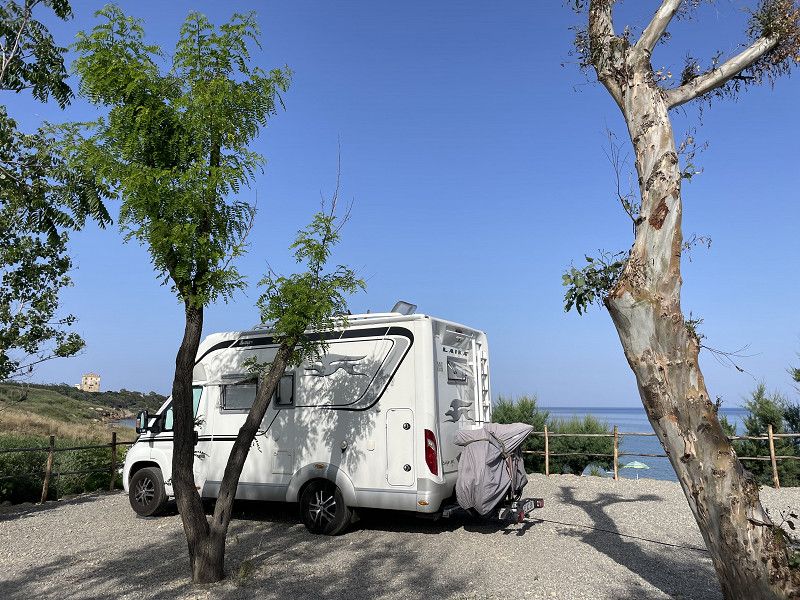
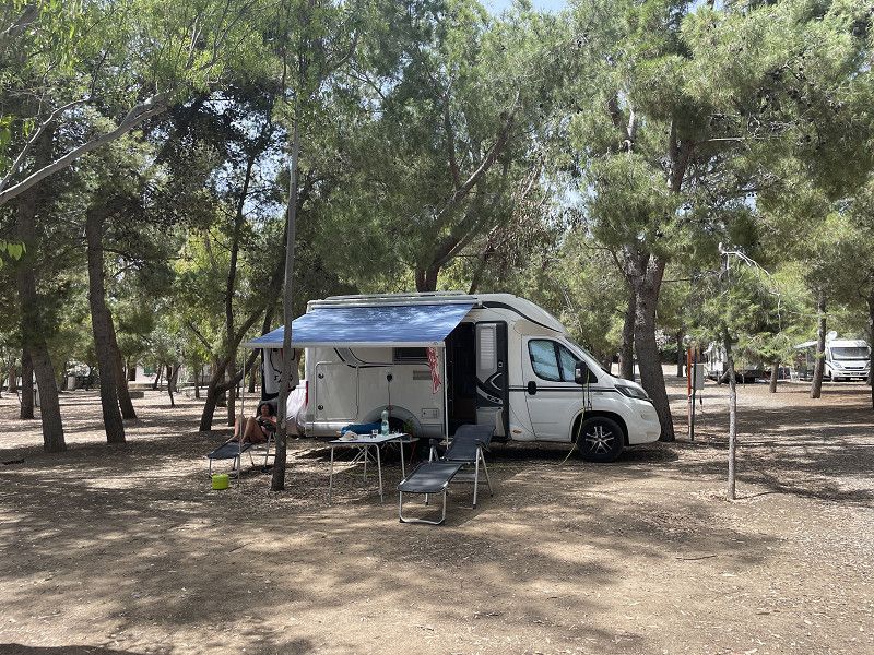
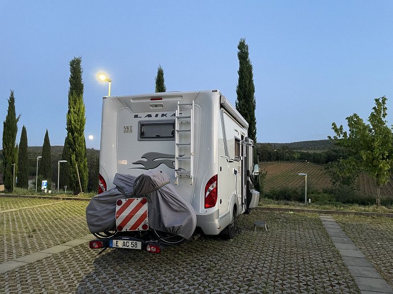
We did this tour from late May to early July. Roughly outlined, it almost went around the boot via Innsbruck, Verona, San Marino, Gargano, Bari, Lecce, Matera, Tropea, Paestum, Rome and Lake Garda. In total, we drove almost 5,700 km and visited 27 pitches and campsites in 46 days. We mostly found these via the park4 Night and ACSI app.
Essen, Deutschland
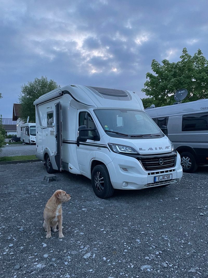
We actually manage to leave at 10 a.m. Before that, "Gustl", our friends' new dog, was examined.
51° 27' 20.3" N 7° 0' 41.6" E
51.4556432 7.0115552
• Head toward Friedensplatz on I. Hagen. Go for 16 m.
• Turn left onto Kennedyplatz. Go for 73 m.
• Turn slightly left onto I. Hagen. Go for 10 m.
• Turn left onto II. Hagen. Go for 105 m.
• Continue on Theaterplatz. Go for 38 m.
• Turn left onto Theaterplatz. Go for 92 m.
• Turn right onto I. Dellbrügge. Go for 228 m.
• Turn right onto Gildehofstraße (K14). Go for 493 m.
• Keep left onto Helbingstraße (K14) toward Düsseldorf/A52/Messe/Gruga/Rellinghausen. Go for 1.6 km.
• Take ramp onto A52 toward Düsseldorf. Go for 14.4 km.
• Take exit 25 toward Krefeld/Köln/Oberhausen onto A3. Go for 52.1 km.
• Continue on A3 toward Frankfurt a.M. Go for 161 km.
• Take exit 48 toward Basel/Stuttgart/Darmstadt/Rüdesheim/Mainz onto A67. Go for 25.1 km.
• Continue on E35 (Darmstädter Kreuz) toward Basel/Karlsruhe/Heidelberg/A5. Go for 1.1 km.
• Continue on A5. Go for 104 km.
• Take exit 46 toward München/Stuttgart/Pforzheim onto A8. Go for 60.8 km.
• Continue on A8 toward München/Ulm/S-Möhringen/Degerloch/Flughafen/Messe. Go for 94.2 km.
• Take exit 65 toward Kempten/Lindau onto A7. Go for 125 km.
• Take exit 139 toward Füssen/Schwangau/Rieden am Forggensee/Hopferau. Go for 524 m.
• Turn left onto B310 toward Füssen/Schwangau/Rieden am Forggensee. Go for 3.9 km.
• Turn right onto Augsburger Straße (B16) toward Schwangau/Krankenhaus Füssen/Hopfen am See/Königsschlösser. Go for 292 m.
• Take the 1st exit from roundabout onto Hopfener Straße (St2008) toward Seeg/Hopfen/Fachklinik/Enzensberg. Go for 331 m.
• Turn left onto Abt-Hafner-Straße. Go for 226 m.
• Turn left onto Abt-Hafner-Straße. Go for 17 m.
• Turn left. Go for 13 m.
• Arrive at your destination on the right.
☍
645,5 km
(5 hrs. 43 min.)
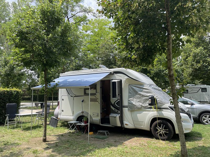
Stellplatz Füssen/Camper's Stop
After we first looked at a parking space at Sepp's, which unfortunately did not correspond at all to the description in Park4 night, we drove to the mobile home parking space in Füssen. For €22/N without electricity, not exactly a snap, but it's quiet and there are plenty of shops (even if we don't need anything😏).
By the way, there is also a digital city tour for Füssen on the Lauschtour app.
Abt-Hafner-Straße 9, 87629, Füssen, Deutschland
47° 34' 56" N 10° 42' 3" E
47.5822222 10.7008333
• Head toward Abt-Hafner-Straße. Go for 13 m.
• Turn right onto Abt-Hafner-Straße. Go for 17 m.
• Turn right onto Abt-Hafner-Straße. Go for 226 m.
• Turn right onto Hopfener Straße (St2008). Go for 310 m.
• Take the 2nd exit from roundabout onto Augsburger Straße (B16) toward A7/Ulm/Innsbruck/Kaufbeuren/Kempten/B310. Go for 359 m.
• Turn left onto B310 toward Ulm/A7/Innsbruck/Kempten/Pfronten/Weißensee/Gewerbegebiet Füssen-West. Go for 3.8 km.
• Take ramp onto A7 toward Innsbruck/Reutte/Fernpass. Go for 2.2 km.
• Continue on Grenztunnel Füssen (B179). Go for 49.2 km.
• Continue on Mieminger Bundesstraße (B189). Go for 13.4 km.
• Take the 1st exit from roundabout onto Krebsbach (L236) toward Innsbruck/Bregenz/Mötz. Go for 5.0 km.
• Turn right and take ramp onto A12 (Inntal Autobahn) toward Innsbruck. Go for 42.8 km.
• Take exit 70 toward Hall-West/B171/Rum/Hall. Go for 688 m.
• Take the 2nd exit from roundabout onto Löfflerweg toward B171/Rum. Go for 354 m.
• Turn right onto Innsbrucker Straße (B171) toward Schwaz/Hall. Go for 913 m.
• Take the 1st exit from roundabout onto Innsbrucker Straße (B171) toward Schwaz. Go for 262 m.
• Turn left onto Trientlstraße. Go for 609 m.
• Arrive at Trientlstraße.
☍
120,2 km
(1 hrs. 38 min.)
Day
Camping Hall
A nice little campsite with somewhat outdated but very clean sanitary facilities. With 2 people, dog and camper we paid 25 €/N without electricity (3 €).
From here we cycled to Innsbruck. The town of Hall is also worth a visit. The small town has a medieval, well-preserved character and can be reached on foot in just under 15 minutes from the CP.
Trientlstraße, 6060 Hall in Tirol, Österreich
47° 16' 56.6" N 11° 29' 26.3" E
47.2824024 11.4906266
• Head toward Kranerbichl on Trientlstraße. Go for 369 m.
• Continue on Scheidensteinstraße. Go for 572 m.
• Continue on Sewerstraße. Go for 33 m.
• Turn right onto Speckbacherstraße. Go for 268 m.
• Take the 2nd exit from Stadtgraben roundabout onto Stadtgraben (L8). Go for 194 m.
• Turn left onto Unterer Stadtplatz (B171). Go for 68 m.
• Turn sharp left onto Unterer Stadtplatz. Go for 16 m.
• Arrive at Unterer Stadtplatz. Your destination is on the right.
☍
1,5 km
( 4 min.)
Day
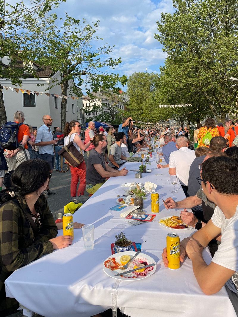
Hall in Tirol, Österreich
On Pentecost Saturday there is the longest table in Tyrol - a folk festival with music, jugglers and lots of food and drink. The center is a long row of tables where people then sit.
47° 16' 49.5" N 11° 30' 21.1" E
47.2804034 11.5058484
• Head toward Schmiedtorgasse on Unterer Stadtplatz. Go for 76 m.
• Turn right onto Stadtgraben (L8). Go for 120 m.
• Take the 5th exit from Stadtgraben roundabout onto Stadtgraben (L8). Go for 226 m.
• Continue on Bundesstraßenabzweigung Hall (B171a). Go for 496 m.
• Turn slightly right and take ramp onto A12 (Inntal Autobahn) toward Brenner/A13/Innsbruck. Go for 7.1 km.
• Keep left onto A13 (Brenner Autobahn) toward Bozen/Brenner/Innsbruck-Süd. Go for 34.5 km.
• Continue on A22 (Autostrada del Brennero). Go for 225 km.
• Take the exit toward Verona Nord/Aeroporto. Go for 1.1 km.
• Take the 2nd exit from roundabout onto SS12. Go for 86 m.
• Take ramp onto SR62 toward Mantova/SS62/Tangenziale/Stazione Verona/Verona Centro/Aeroporto/Vicenza/Rovigo/Ferrara/Legnago/Villafranca. Go for 711 m.
• Take ramp onto SS12 toward Verona Centro/Verona Stazione/S. Lucia/S. Massimo. Go for 6.2 km.
• Keep right onto Viale Luciano dal Cero (SS12) toward Centro/Ospedale Borgo Roma/Legnago-Rovigo/Modena. Go for 281 m.
• Turn left onto Strada Statale dell'Abetone e del Brennero (SS12). Go for 159 m.
• Turn slightly left onto Piazzale Porta Nuova toward Centro. Go for 174 m.
• Continue on Corso Porta Nuova. Go for 792 m.
• Arrive at Corso Porta Nuova. Your destination is on the left.
☍
277,1 km
(2 hrs. 54 min.)
Day
Verona, Italien
On the way we decided to look at Verona again and to spend a night there on the CP Verona.
In the app izi.travel there is an interesting city tour through Verona with all the main sights. As a UNESCO World Heritage Site, the city attracts many visitors. It took us about 20 minutes by bike from the CP, although the route is quite chaotic. The bike lanes (if any) run back and forth and often against the direction of travel of the cars.
45° 26' 18.2" N 10° 59' 29.8" E
45.4383842 10.9916215
• Head toward Via dei Mutilati on Corso Porta Nuova. Go for 800 m.
• Continue on Piazzale Porta Nuova. Go for 60 m.
• Keep left onto Piazzale Porta Nuova. Go for 21 m.
• Keep right onto Strada Statale dell'Abetone e del Brennero (SS12). Go for 584 m.
• Take ramp onto Via Santa Teresa (SS12) toward Modena-Ferrara/Rovigo-Legnago/SS434/Ospedale Borgo Roma. Go for 424 m.
• Keep right onto Via Santa Teresa. Go for 359 m.
• Take the 1st exit from roundabout onto Via Santa Teresa. Go for 118 m.
• Continue on Via Scuderlando. Go for 460 m.
• Turn left onto Via Fiume. Go for 175 m.
• Turn slightly right onto Via Volturno. Go for 122 m.
• Continue on Via San Giacomo (SS12). Go for 2.2 km.
• Arrive at Strada Statale dell'Abetone e del Brennero (SS12). Your destination is on the left.
☍
5,3 km
( 10 min.)
Camping Verona Village
For 28 € (23 € ASCSI + 5 € tourist tax 🥴) a very well organized campsite with parking space character. Not very quiet, as it is right on a main road.
Via Forte Tomba 44, 37135, Verona, Italien
45° 23' 34.6" N 10° 59' 34.9" E
45.3929461 10.9930167
• Head north on Strada Statale dell'Abetone e del Brennero (SS12). Go for 945 m.
• Turn left onto Via Louis Pasteur toward Centro/Autostrade/Vigasio. Go for 720 m.
• Continue on Via Flavio Gioia toward Autostrade/Tangenziali. Go for 653 m.
• Turn right onto Viale delle Nazioni. Go for 119 m.
• Take ramp. Go for 370 m.
• Take ramp onto A4 (Autostrada della Serenissima) toward Milano/E45/Brennero-Modena/A22. Go for 4.1 km.
• Take the exit toward Brennero-Modena/Verona Nord/Aeroporto/Modena/Mantova/Bologna/A1 onto A22 (Autostrada del Brennero). Go for 85.9 km.
• Take the left exit toward Bologna/Roma/Modena onto A1 (Autostrada del Sole). Go for 33.3 km.
• Keep right onto A14 (Autostrada Adriatica) toward Ancona/Ravenna/Padova/A13/Tangenziale/Bologna Borgo Panigale/Bologna Centro/Aeroporto Bologna/Fiera Bologna. Go for 128 km.
• Take the exit toward Rimini Sud/San Marino. Go for 816 m.
• Continue on Via Consolare (SS72). Go for 9.9 km.
• Continue on Via Tre Settembre. Go for 1.2 km.
• Continue on Via Quattro Giugno. Go for 822 m.
• Take the 3rd exit from roundabout onto Via Quattro Giugno. Go for 797 m.
• Continue on Via Cinque Febbraio. Go for 241 m.
• Turn right onto Via Ranco. Go for 101 m.
• Keep right onto Via Ranco. Go for 807 m.
• Continue on Strada Nona Gualdaria. Go for 478 m.
• Turn right onto Strada Auloceto. Go for 215 m.
• Turn left onto Strada di San Michele. Go for 187 m.
• Turn right onto Strada Filbezia. Go for 247 m.
• Arrive at Strada Filbezia. Your destination is on the right.
☍
269,9 km
(2 hrs. 38 min.)
Day
Centro Vacance San Marino
Very nice ACSI CP. Unfortunately, the swimming pool was only open from June 1st. The CP has many facilities for children.
A highlight on the CP are fireflies. They can be seen flying in the evenings in May/June. That brings back childhood memories. 🤗
Strada San Michele 50, 47893, San Marino, San Marino
43° 57' 32.2" N 12° 27' 30.4" E
43.9589480 12.4584572
• Head toward Strada di San Michele on Strada Filbezia. Go for 247 m.
• Turn right onto Strada di San Michele. Go for 229 m.
• Continue on Via Ca' dei Lunghi. Go for 400 m.
• Take the 1st exit from roundabout onto Via Ca' dei Lunghi. Go for 95 m.
• Take the 2nd exit from roundabout onto Via Leo Marino Dominici. Go for 795 m.
• Turn right onto Strada Sesta Gualdaria. Go for 243 m.
• Turn slightly right onto Via Fiordalisio. Go for 240 m.
• Turn left onto Via delle Felci. Go for 69 m.
• Arrive at Via delle Felci. Your destination is on the left.
☍
2,3 km
( 5 min.)
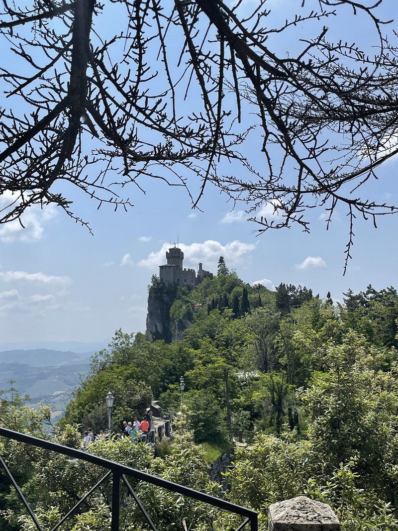
Day
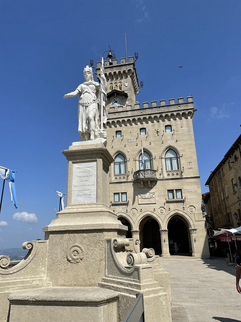
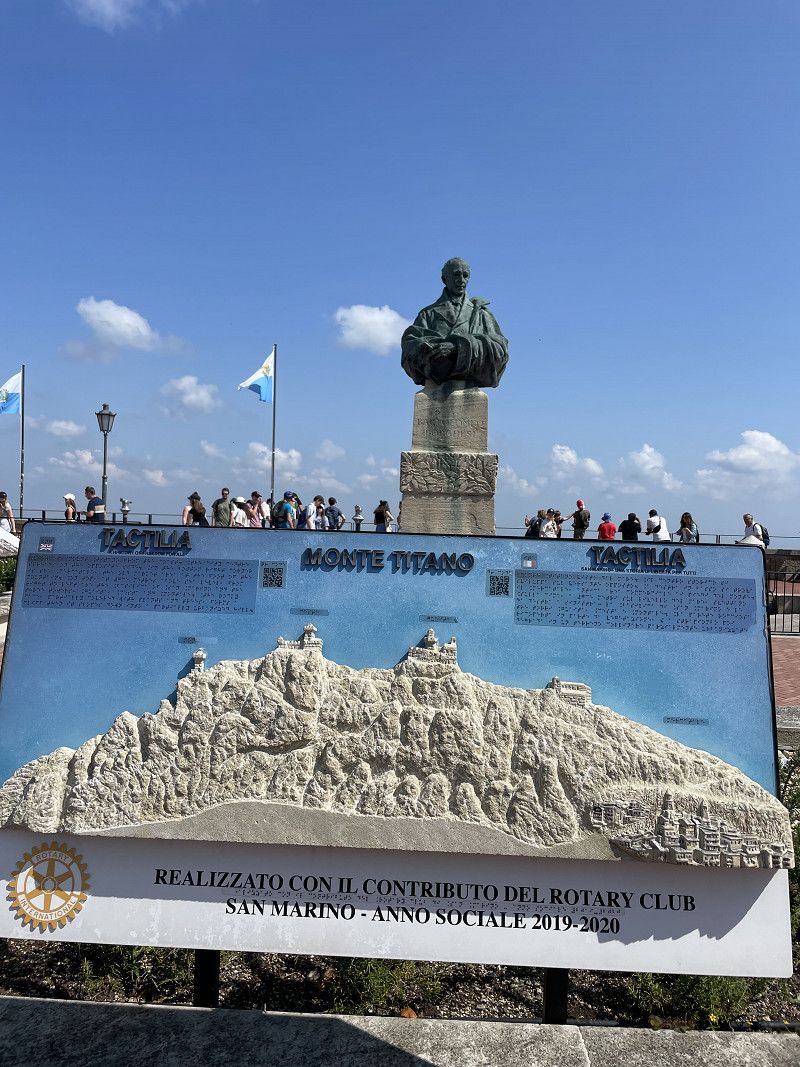
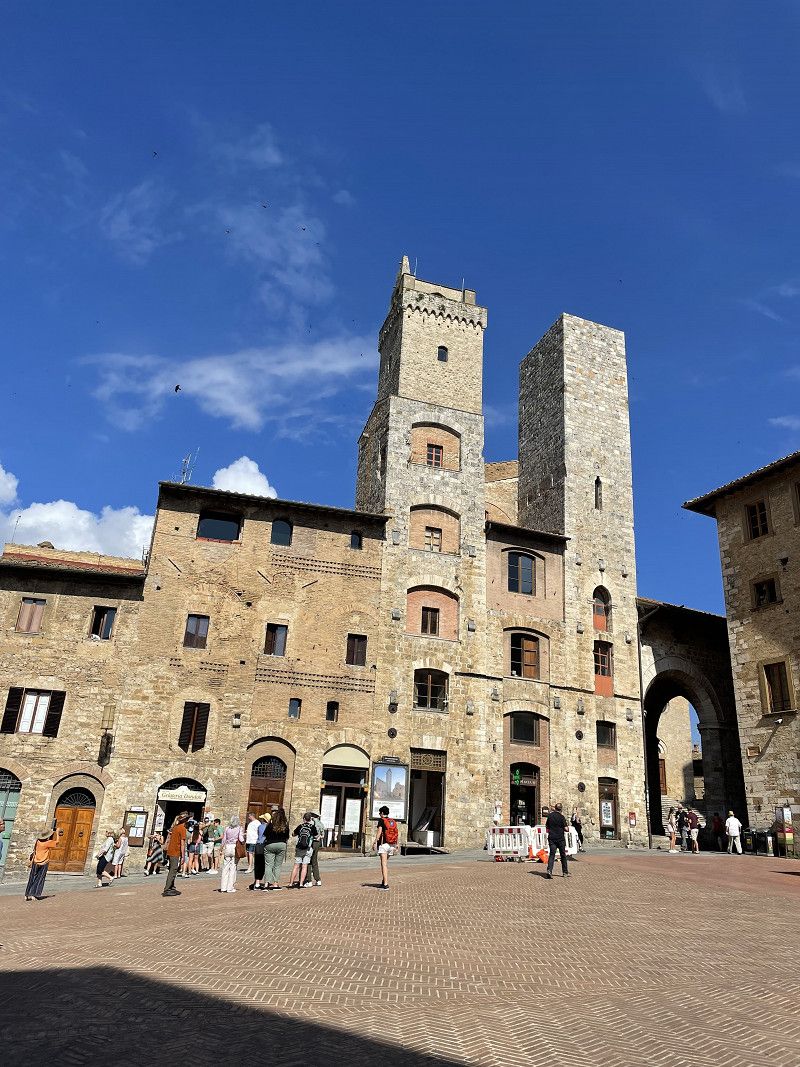
San Marino
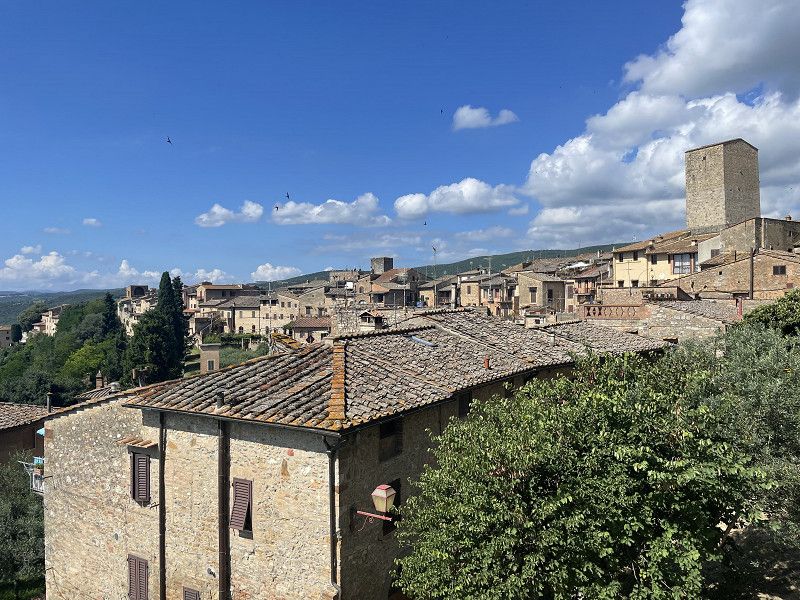
It takes a good half hour uphill from CP San Marino to the city center by bike. On the way you pass a free parking space directly at the valley station of the cable car.
Unfortunately, the parking space for bicycles in the village is very limited. After a long search we found a place. But you can also take the bus from the CP to the city.
On a tour of the city you can admire the three towers and the many small streets. We left out the Coin and Stamp Museum and the Vampire Museum.
43° 56' 32.5" N 12° 27' 28" E
43.9423600 12.4577770
• Head west on Via delle Felci. Go for 69 m.
• Turn right onto Via Fiordalisio. Go for 240 m.
• Turn slightly left onto Strada Sesta Gualdaria. Go for 263 m.
• Turn left onto Via Leo Marino Dominici. Go for 731 m.
• Take the 1st exit from roundabout onto Via Ca' dei Lunghi. Go for 75 m.
• Take the 3rd exit from roundabout onto Via Ca' dei Lunghi. Go for 506 m.
• Continue on Strada Nona Gualdaria. Go for 289 m.
• Turn left onto Strada Auloceto. Go for 215 m.
• Turn left onto Strada di San Michele. Go for 187 m.
• Turn right onto Strada Filbezia. Go for 247 m.
• Arrive at Strada Filbezia. Your destination is on the right.
☍
2,8 km
( 6 min.)
Centro Vacance San Marino
Strada San Michele 50, 47893, San Marino, San Marino
43° 57' 32.2" N 12° 27' 30.4" E
43.9589480 12.4584572
• Head toward Strada di San Michele on Strada Filbezia. Go for 247 m.
• Turn left onto Strada di San Michele. Go for 187 m.
• Turn right onto Strada Auloceto. Go for 215 m.
• Turn left onto Strada Nona Gualdaria. Go for 478 m.
• Continue on Via Ranco. Go for 837 m.
• Keep right toward Via Cinque Febbraio. Go for 266 m.
• Continue on Via Cinque Febbraio. Go for 490 m.
• Continue on Via Quattro Giugno. Go for 754 m.
• Take the 1st exit from roundabout onto Via Quattro Giugno. Go for 860 m.
• Continue on Via Tre Settembre. Go for 1.2 km.
• Continue on Strada Statale Consolare Rimini San Marino (SS72). Go for 9.7 km.
• Take ramp onto A14 (Autostrada Adriatica) toward Ancona. Go for 86.0 km.
• Take the exit toward Ancona Nord/Jesi. Go for 1.1 km.
• Take the 2nd exit from roundabout toward Aeroporto/Fabriano/Jesi/SS76/Ancona/SS16/Roma. Go for 49 m.
• Continue toward Strada Statale della Val d'Esino/SS76. Go for 57 m.
• Take left ramp onto Strada Statale della Val d'Esino (SS76) toward Jesi/Fabriano-Roma. Go for 41.6 km.
• Turn right. Go for 256 m.
• Take the 2nd exit from roundabout. Go for 91 m.
• Continue on Frazione Camponocecchio. Go for 498 m.
• Turn slightly right onto Via Guglielmo Marconi. Go for 330 m.
• Turn left onto Via Guglielmo Marconi. Go for 35 m.
• Arrive at Via Guglielmo Marconi. Your destination is on the right.
☍
145,3 km
(1 hrs. 28 min.)
Day
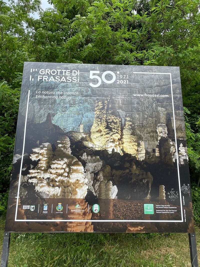
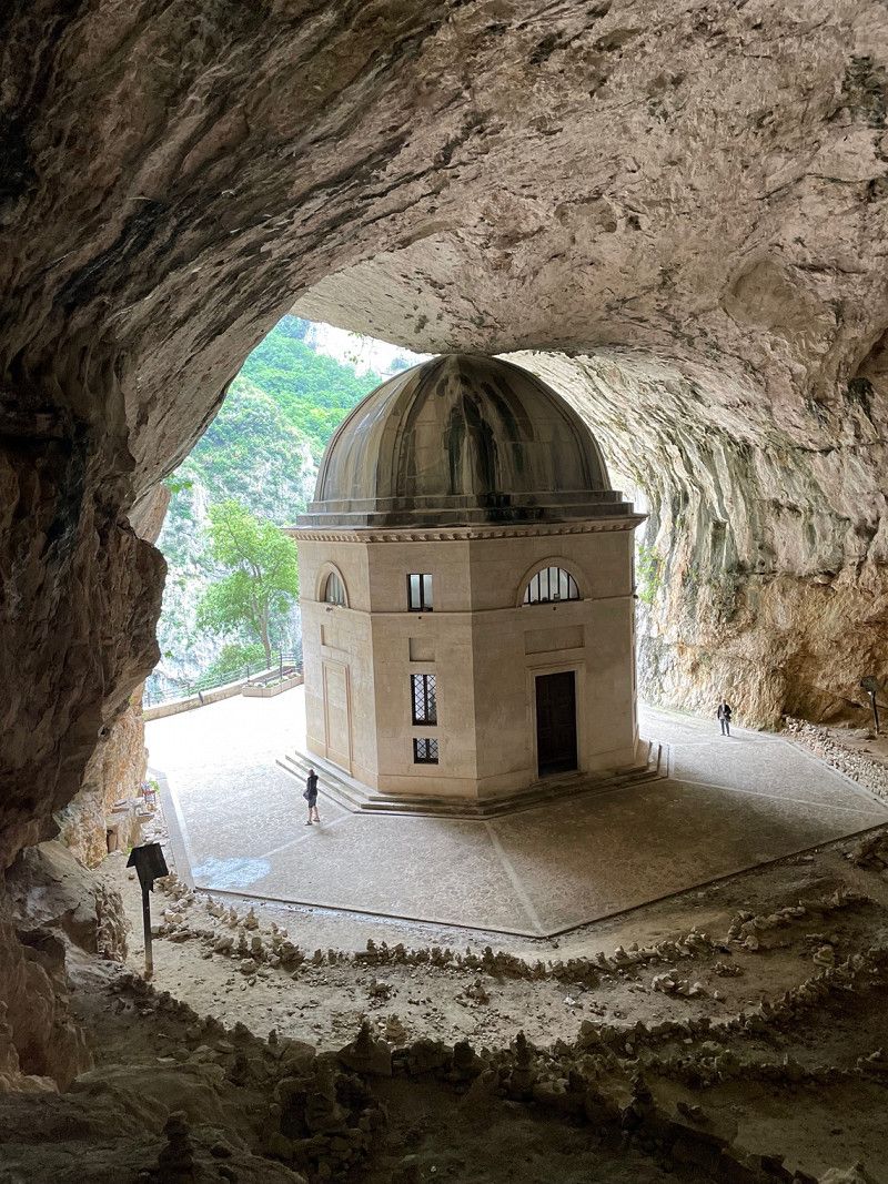
Parkplatz Höhle Frassasi
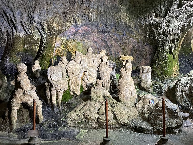
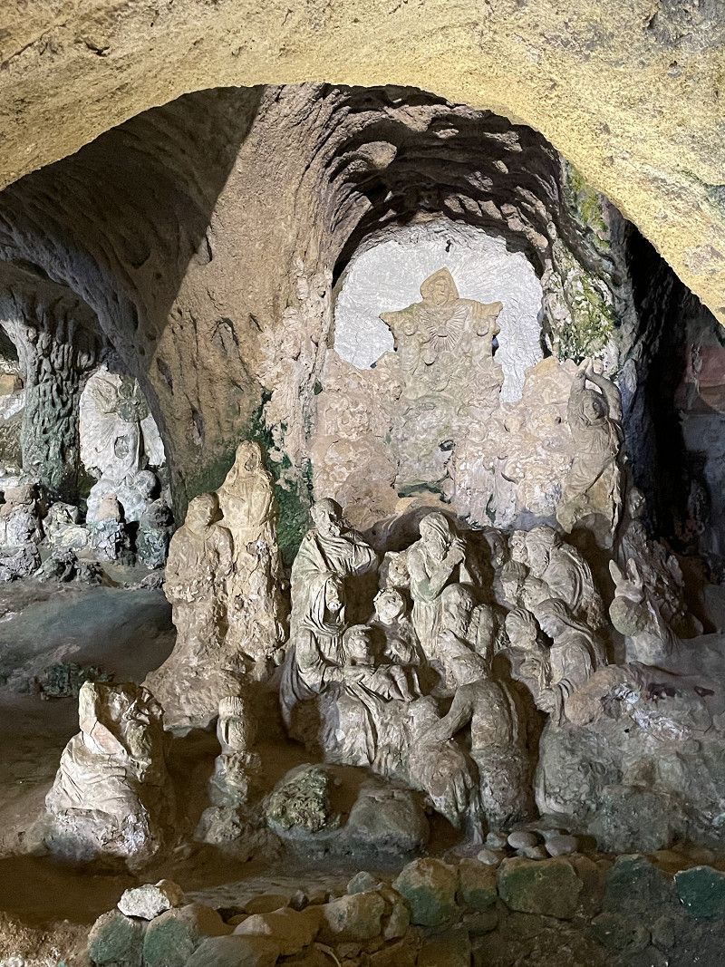
You can also stay overnight in the parking lot for free. The cave can only be entered with a guide. Since we have already visited some heights, we drove on to the Santa Marie infra saxa chapel.
Via Guglielmo Marconi, 10, 60040 Genga AN, Italien
43° 24' 17.1" N 12° 58' 39.4" E
43.4047620 12.9776030
• Head north on Via Guglielmo Marconi. Go for 35 m.
• Turn left onto Via Guglielmo Marconi. Go for 234 m.
• Continue on Viale Giovanni Marinelli. Go for 841 m.
• Take the 2nd exit from Viale Giovanni Marinelli roundabout onto Località San Vittore. Go for 72 m.
• Continue on Viale Giovanni Marinelli. Go for 2.0 km.
• Arrive at Viale Giovanni Marinelli.
☍
3,2 km
( 4 min.)
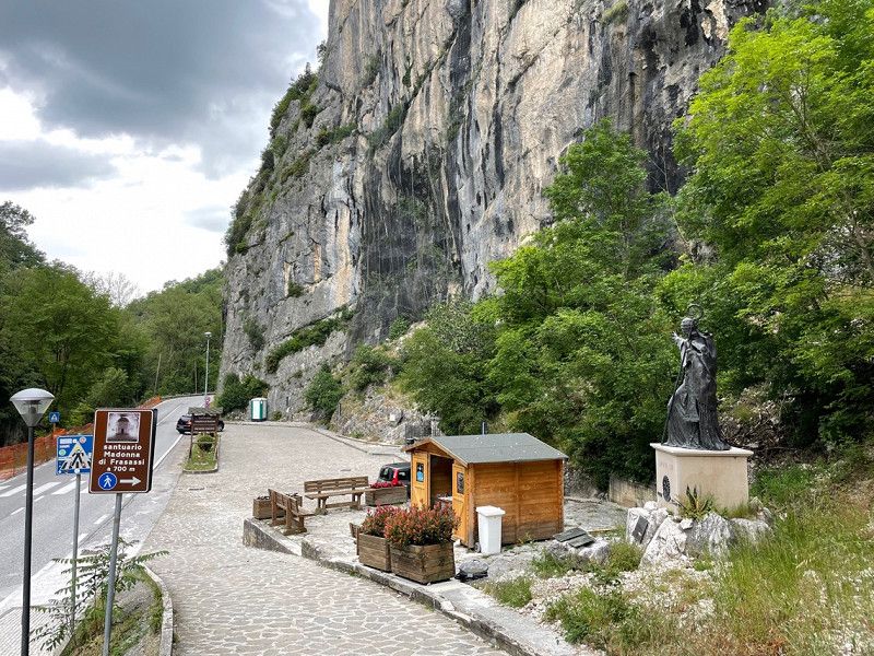
Eremo di Santa Maria Infra Saxa, Genga, Ancona, Italien
You walk about 800 m steeply uphill from the car park on the road to the imposing church in a rock niche. The ascent is worthwhile and with 6 €/person you are there.
60040 Genga, Ancona, Italien
43° 24' 10.6" N 12° 57' 16.3" E
43.4029402 12.9545140
• Head northwest on Viale Giovanni Marinelli. Go for 40 m.
• Turn right toward Viale Giovanni Marinelli. Go for 78 m.
• Turn left onto Viale Giovanni Marinelli. Go for 2.0 km.
• Take the 1st exit from Viale Giovanni Marinelli roundabout onto Viale Giovanni Marinelli. Go for 1.1 km.
• Continue on Via Guglielmo Marconi. Go for 346 m.
• Turn right onto Strada Statale Muccese (SS256). Go for 805 m.
• Keep left onto Località Gattuccio (SS256). Go for 286 m.
• Continue on SS256. Go for 548 m.
• Continue on Strada Statale Muccese (SS256). Go for 95 m.
• Turn right onto Strada Statale Muccese (SS256). Go for 175 m.
• Take the 1st exit from roundabout onto Strada Statale della Val d'Esino (SS76). Go for 42.3 km.
• Take ramp toward A14. Go for 347 m.
• Continue toward Autostrada Adriatica/A14. Go for 33 m.
• Take the 2nd exit from roundabout onto A14 (Autostrada Adriatica) toward Autostrada/Bologna-Taranto/Pescara. Go for 342 km.
• Take the exit toward Foggia/Manfredonia/S.Giovanni Rotondo onto SS89. Go for 39.1 km.
• Pass 2 roundabouts and continue on SS89. Go for 12.1 km.
• Turn right onto SS89 toward Mattinata. Go for 519 m.
• Keep right onto SP53. Go for 1.2 km.
• Turn right onto Strada Provinciale Mattinata Vieste (SP53) toward Vieste Litoranea. Go for 9.1 km.
• Turn right toward Strada Provinciale Mattinata Vieste/SP53. Go for 50 m.
• Continue on Strada Provinciale Mattinata Vieste (SP53). Go for 20.6 km.
• Turn right. Go for 326 m.
• Turn slightly right. Go for 85 m.
• Arrive at your destination on the left.
☍
473,3 km
(4 hrs. 45 min.)
Camping La Medusa
After we had unsuccessfully approached two pitches inland, we drove to this ACSI pitch for €20.20/N. The place is a matter of taste, but if you like a lot of hustle and bustle, the CP is the right choice. It wasn't our thing. But the staff is friendly and accommodating.
Day
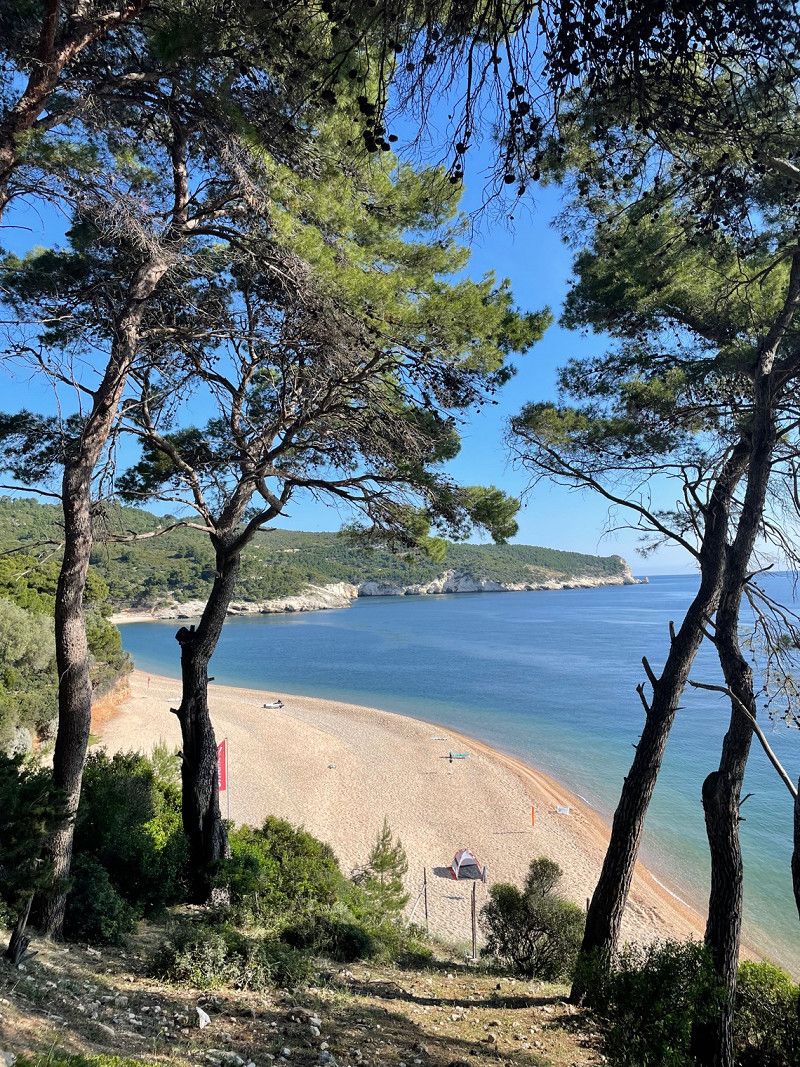
Campeggio Baia dei Campi
After we drove to our old place at Capo Vieste and found that the audience there had hardly changed, but we were older, we went to the CP south of Vieste. We found it very good there.
The CP is in a bay and the site has shady pitches under pine trees. Pitches directly by the sea can only be booked for stays of 7 days or more. We paid 19€/N with ACSI.
Litoranea per Pugnochiuso, 71019, Vieste, Italien
41° 48' 56" N 16° 11' 40" E
41.8155500 16.1944400
• Head northwest. Go for 411 m.
• Turn right onto Strada Provinciale Mattinata Vieste (SP53). Go for 10.7 km.
• Turn right onto Via Madonna della Libera. Go for 251 m.
• Turn left onto Viale 24 Maggio. Go for 21 m.
• Turn right onto Via Milano. Go for 11 m.
• Arrive at Via Milano. Your destination is on the right.
☍
11,4 km
( 16 min.)
Day
Day
Vieste, Foggia, Italien
It takes about 30 minutes by bike from the CP, but along the coastal road, which is not without its dangers. The winding streets are definitely worth a visit. From a distance the town looks like "Little Bonifacio". You can also see the tourist attraction of the Felsentor on the bike route.
71019 Vieste, Foggia, Italien
41° 52' 56.9" N 16° 10' 36.3" E
41.8824764 16.1767489
• Head toward Via Papa Giovanni XXIII on Via Milano. Go for 43 m.
• Turn left onto Via Papa Giovanni XXIII. Go for 33 m.
• Turn right onto Via Trieste. Go for 75 m.
• Turn right onto Via Santa Maria di Merino. Go for 34 m.
• Turn right onto Via Vittorio Veneto. Go for 106 m.
• Turn right onto Viale 24 Maggio. Go for 300 m.
• Take the 4th exit from roundabout onto Via Guglielmo Marconi. Go for 254 m.
• Continue on Lungomare Enrico Mattei toward Mattinata/Litoranea/Autostrada. Go for 10.7 km.
• Turn left. Go for 326 m.
• Turn slightly right. Go for 85 m.
• Arrive at your destination on the left.
☍
11,9 km
( 17 min.)
Day
Day
Campeggio Baia dei Campi
Litoranea per Pugnochiuso, 71019, Vieste, Italien
41° 48' 56" N 16° 11' 40" E
41.8155500 16.1944400
• Head toward Strada Provinciale Campi-Pugnochiuso Coppa San Tecla. Go for 259 m.
• Turn right onto Strada Provinciale Campi-Pugnochiuso Coppa San Tecla (SP54). Go for 448 m.
• Turn left onto Strada Provinciale Mattinata Vieste (SP53). Go for 20.5 km.
• Continue on SS89. Go for 36 m.
• Turn left onto Strada Provinciale Mattinata Vieste (SP53). Go for 9.0 km.
• Keep left toward SP53. Go for 44 m.
• Turn left onto SP53. Go for 1.8 km.
• Continue on SS89. Go for 7.6 km.
• Take the 2nd exit from roundabout onto SS89 toward Autostrada/San Giovanni R.Do. Go for 4.5 km.
• Take the 2nd exit from roundabout onto SS89 toward Autostrada/Foggia/S. Giovanni R.Do/Manfredonia. Go for 9.3 km.
• Take ramp onto SS89 toward Manfredonia Sud. Go for 1.7 km.
• Turn right onto SP141. Go for 8.3 km.
• Take the 2nd exit from roundabout onto SP141. Go for 5.0 km.
• Turn right onto Strada Statale Rivolese (SS545) toward Autostrade/Cerignola/Foggia. Go for 12.2 km.
• Pass 2 roundabouts and continue on Strada Statale Rivolese (SS545). Go for 7.0 km.
• Take ramp onto A14 (Autostrada Adriatica) toward Bari. Go for 83.2 km.
• Keep right onto A14 toward Bari Centro/Porto Bari/Brindisi-Lecce/Bari Nord. Go for 4.6 km.
• Take the exit toward Bari Centro/E843/A14/Taranto/Brindisi-Lecce onto SS16 (Tangenziale di Bari). Go for 51.2 km.
• Take ramp. Go for 242 m.
• Continue toward Viale Aldo Moro. Go for 458 m.
• Continue on Viale Aldo Moro. Go for 283 m.
• Keep right toward Monopoli. Go for 153 m.
• Continue on Viale Aldo Moro. Go for 149 m.
• Turn right onto Contrada Santo Stefano Traversa 1. Go for 520 m.
• Turn right onto Contrada Santo Stefano. Go for 203 m.
• Arrive at Contrada Santo Stefano. Your destination is on the right.
☍
228,4 km
(2 hrs. 27 min.)
Campeggio Santo Stefano
Very nice little campsite with a small beach in a bay. From here you can easily reach Monopoli and Polignano by bike.
Contrada Santo Stefano, 70043, Monopoli, Italien
40° 55' 40.5" N 17° 19' 12.6" E
40.9279300 17.3201600
• Head south on Contrada Santo Stefano.
• Turn left onto Contrada Santo Stefano. Go for 15 m.
• Turn left onto Contrada Santo Stefano. Go for 214 m.
• Continue on Contrada Santo Stefano Traversa 1. Go for 520 m.
• Turn left onto Viale Aldo Moro toward Bari/Brindisi. Go for 518 m.
• Take ramp onto Strada Statale Adriatica (SS16) toward Bari. Go for 10.5 km.
• Take ramp onto Via Pompeo Sarnelli toward Polignano a Mare Sud. Go for 892 m.
• Take the 2nd exit from roundabout onto Via Pompeo Sarnelli. Go for 655 m.
• Turn right onto Via Francesco Antonio Pace. Go for 105 m.
• Turn left onto Via Sant'Antonio. Go for 6 m.
• Turn right onto Via Viola. Go for 66 m.
• Turn left onto Via Atropo. Go for 34 m.
• Arrive at Via Atropo.
☍
13,5 km
( 11 min.)
Day
Day
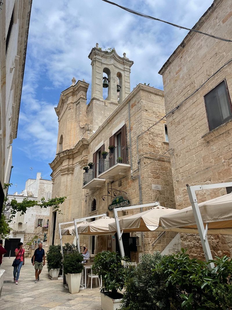
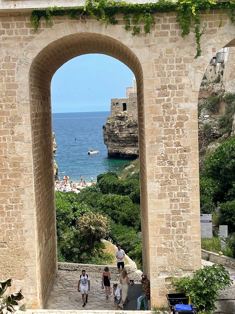
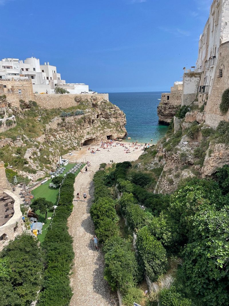
Polignano a Mare, Bari, Italien
Polignano a Mare is a town built on rocks with a town beach that is more like a stage as it can be seen from several points in town.
Red Bull Cliff Diving has been held here several times. A highlight of the city is the grandiose Grotta Palazzese, a cave restaurant overlooking the sea.
In the narrow streets there are many fashion and souvenir shops.
70044 Polignano a Mare, Bari, Italien
40° 59' 41.6" N 17° 13' 21.4" E
40.9948946 17.2226100
• Head toward Via Garofalo on Via Atropo. Go for 72 m.
• Turn left onto Via Gelsomino. Go for 116 m.
• Turn left onto Via Pompeo Sarnelli. Go for 698 m.
• Take the 2nd exit from roundabout onto Via Pompeo Sarnelli. Go for 666 m.
• Take ramp toward Brindisi/SS16/E55. Go for 170 m.
• Turn left toward Strada Statale Adriatica/SS16. Go for 148 m.
• Turn left and take ramp onto Strada Statale Adriatica (SS16) toward Brindisi. Go for 10.9 km.
• Take ramp. Go for 242 m.
• Continue toward Viale Aldo Moro. Go for 458 m.
• Continue on Viale Aldo Moro. Go for 283 m.
• Keep right toward Monopoli. Go for 153 m.
• Continue on Viale Aldo Moro. Go for 149 m.
• Turn right onto Contrada Santo Stefano Traversa 1. Go for 520 m.
• Turn left onto Via Romana Traiana. Go for 1.3 km.
• Turn right onto Via Marianna Farnararo. Go for 157 m.
• Turn right onto Via Procaccia. Go for 1.1 km.
• Turn slightly right onto Strada Procaccia. Go for 733 m.
• Turn left onto Strada Procaccia. Go for 89 m.
• Turn right onto Contrada Santo Stefano. Go for 365 m.
• Arrive at Contrada Santo Stefano. Your destination is on the right.
☍
18,3 km
( 20 min.)
Day
Camping Santo Stefano, Contrada Santo Stefano, Monopoli, Bari, Italien
Contrada S. Stefano, 70043 Monopoli BA, Italien
40° 55' 33.6" N 17° 19' 55.2" E
40.9260123 17.3320116
• Head northwest on Contrada Santo Stefano. Go for 365 m.
• Turn left onto Strada Procaccia. Go for 745 m.
• Turn slightly left toward Contrada Santo Stefano. Go for 10 m.
• Turn right onto Contrada Santo Stefano. Go for 2.0 km.
• Take the 1st exit from roundabout onto Via Lepanto. Go for 1.1 km.
• Continue on Via Emilio Indelli. Go for 70 m.
• Turn left onto Via Palestro. Go for 194 m.
• Turn right onto Via Cialdini. Go for 283 m.
• Continue on Via Capitano Pirrelli. Go for 72 m.
• Arrive at Via Capitano Pirrelli.
☍
4,9 km
( 9 min.)
Monopoli, Bari, Italien
A very nice place with narrow streets, but also shopping opportunities and commercial streets. There are many churches to visit in the old town.
70043 Monopoli, Bari, Italien
40° 57' 9.1" N 17° 17' 54.8" E
40.9525166 17.2985559
• Head toward Via Magenta on Via Capitano Pirrelli. Go for 2 m.
• Turn left onto Via Magenta. Go for 280 m.
• Turn left onto Via Ghezzi. Go for 68 m.
• Turn right onto Via Amleto Pesce. Go for 537 m.
• Take the 3rd exit from roundabout onto Viale Aldo Moro. Go for 409 m.
• Take the 2nd exit from roundabout onto Viale Aldo Moro. Go for 489 m.
• Continue toward Strada Contrada Belvedere. Go for 30 m.
• Take the 1st exit from roundabout onto Strada Contrada Belvedere. Go for 4.9 km.
• Turn right onto Raccordo Monopopoli-Alb. Castell-S. di Fas (SP187) toward Gorgofreddo/Antonelli/Castellana G. Go for 2.4 km.
• Turn left onto Strada Provinciale Selva di Fasano (SP146) toward Alberobello. Go for 1.3 km.
• Take the 1st exit from roundabout toward Alberobello. Go for 35 m.
• Continue on Contrada Impalata (SP113). Go for 6.5 km.
• Take the 2nd exit from roundabout toward Alberobello. Go for 79 m.
• Continue on Strada Provinciale Monopoli-Alberobello (SP113). Go for 3.8 km.
• Continue on Strada Provinciale Monopoli-Alberobello (SP113). Go for 231 m.
• Continue toward Viale Putignano. Go for 23 m.
• Take the 3rd exit from roundabout onto Viale Putignano toward Centro. Go for 361 m.
• Keep right onto Viale Bari. Go for 231 m.
• Arrive at Viale Bari. Your destination is on the left.
☍
21,7 km
( 23 min.)
Alberobello, Bari, Italien
The trulli round houses, built without mortar, are a must-see on a tour of Italy.
The small town of Alberobello includes an entire closed quarter, which is entirely built up with trulli. It is a UNESCO World Heritage Site.
The neighborhood is reminiscent of a fairy tale setting from a movie, with hundreds of white pointed-hat houses, with splashes of blue, green, and sand-colored pops of color. Some trulli are more than 300 years old. They protect you from the heat in summer and keep you warm in winter.
The place is an absolute tourist attraction, ie already in the preseason you fight your way through crowds. It is therefore definitely worth taking a tour around Alberobello. Here you can look at many trulli in peace. For us, this tour was the real highlight.
70011 Alberobello BA, Italien
40° 47' 11.1" N 17° 14' 27.3" E
40.7864228 17.2409304
• Head toward Viale Aldo Moro on Viale Bari. Go for 231 m.
• Continue on Viale Putignano. Go for 283 m.
• Continue toward Viale Luigi Einaudi/SS172. Go for 22 m.
• Take the 1st exit from roundabout onto Viale Luigi Einaudi (SS172) toward Locorotondo/Martina Franca/Taranto. Go for 38 m.
• Arrive at Viale Luigi Einaudi (SS172).
☍
0,6 km
( 1 min.)
Parkplatz Alberobello
Right next to a supermarket, about 15 minutes' walk to the trullis
Viale Luigi Einaudi, 8, 70011 Alberobello BA, Italien
40° 47' 26.8" N 17° 14' 34.6" E
40.7907755 17.2429398
• Head toward Via G. Turi on Viale Luigi Einaudi (SS172). Go for 223 m.
• Continue on Viale Luigi Einaudi (SS172). Go for 38 m.
• Pass 2 roundabouts and continue on SS172. Go for 8.9 km.
• Arrive at Via Alberobello (SS172). Your destination is on the left.
☍
9,2 km
( 9 min.)
Locorotondo, Bari, Italien
We only stopped here for lunch. The circular village should also be worth a visit.
70010 Locorotondo, Bari, Italien
40° 45' 21.3" N 17° 19' 34.6" E
40.7559127 17.3262806
• Head east on Via Alberobello (SS172). Go for 11 m.
• Turn left onto Piazza Guglielmo Marconi (SS172dir). Go for 76 m.
• Turn right onto Piazza Guglielmo Marconi (SS172dir). Go for 8.4 km.
• Pass 2 roundabouts and continue on SS172dir. Go for 3.1 km.
• Take ramp onto Strada Statale Adriatica (SS16) toward Brindisi/SS379. Go for 2.9 km.
• Keep left onto Strada Statale di Egnazia (SS379) toward Brindisi/Lecce/Ostuni. Go for 13.9 km.
• Take ramp toward Ostuni. Go for 157 m.
• Take the 3rd exit from roundabout onto SP19 toward Ostuni. Go for 8.2 km.
• Take the 2nd exit from roundabout onto Contrada Sant'Angelo. Go for 428 m.
• Take the 1st exit from roundabout onto Contrada Sant'Angelo. Go for 174 m.
• Take the 2nd exit from roundabout onto Contrada Sant'Angelo. Go for 569 m.
• Turn right onto Via Giosuè Pinto. Go for 81 m.
• Arrive at Via Giosuè Pinto. Your destination is on the left.
☍
38,1 km
( 30 min.)
Day
Parkplatz mit VE in Ostuni
From the parking lot it is a 10 minute walk to the center. There is fresh water and a drain for gray water. Payment is made at a machine (€0.8/h until June 15th, then €0.9).
As with all car parks, it is quite noisy at night. But the great view down to the coast and proximity to the great white town of Ostuni makes up for it.
Via Giosuè Pinto, 34, 72017 Ostuni BR, Italien
40° 43' 58.6" N 17° 34' 55.8" E
40.7329332 17.5821542
• Head northeast on Via Giosuè Pinto. Go for 81 m.
• Turn right onto Contrada Rosara. Go for 839 m.
• Turn left onto SP21. Go for 6.8 km.
• Turn right toward Strada Statale di Egnazia/SS379. Go for 482 m.
• Turn left toward Svincolo Torre Pozzella. Go for 32 m.
• Take ramp onto Strada Statale di Egnazia (SS379). Go for 25.7 km.
• Continue on Strada Statale Adriatica (SS16). Go for 4.4 km.
• Continue on SS613. Go for 22.9 km.
• Take ramp onto SP100 toward Trepuzzi/Squinzano. Go for 7.6 km.
• Turn right onto Via Litoranea Salentina Sud (SP133) toward San Cataldo/Torre Rinalda. Go for 1.7 km.
• Turn left. Go for 168 m.
• Take the 1st exit from roundabout. Go for 38 m.
• Turn slightly left. Go for 91 m.
• Turn right. Go for 40 m.
• Turn left. Go for 120 m.
• Arrive at your destination on the right.
☍
70,9 km
( 44 min.)
Torre Rinalda Beach Camping & Resort
A large CP with swimming pool and shops. Only a few drinking water taps and central waste disposal. ACSI space for €23/night.
Via Simeone D'Antona 1, 73100, Lecce, Italien
40° 28' 59.6" N 18° 8' 53.8" E
40.4832100 18.1482900
• Head north.
• Arrive at your destination on the right.
☍
Distance not available
(Duration not available)
Day
Day
Lecce centro, Via Giuseppe Palmieri, Lecce, Italien
By bike you can reach Lecce from the campsite in about an hour (18 km). It is advisable to take the trip over the streets. Google indicates a route over farm roads, but this only makes sense with a mountain bike.
In Lecce itself you will be struck by baroque facades and a multitude of churches. To gain access, you usually have to book tickets online. We saved this because clerical pomp is not our thing. Nevertheless, we really liked the city. You should definitely plan a tour - if only because of the good ice cream 🍦.
Day
Torre Rinalda Beach Camping & Resort
Via Simeone D'Antona 1, 73100, Lecce, Italien
40° 28' 59.6" N 18° 8' 53.8" E
40.4832100 18.1482900
• Head south. Go for 120 m.
• Turn right. Go for 40 m.
• Turn left. Go for 110 m.
• Take the 4th exit from roundabout. Go for 230 m.
• Turn left onto Strada Provinciale Frigole San Cataldo (SP133). Go for 1.1 km.
• Turn right onto Strada Provinciale Surbo-Torre Rinalda (SP93). Go for 2.6 km.
• Turn left onto Via Giacomo Monticelli. Go for 3.8 km.
• Take the 2nd exit from roundabout onto Via Giuseppe Agostino Roggerone toward S. Ligorio/S.Ligorio. Go for 3.0 km.
• Take the 1st exit from roundabout onto Strada Provinciale Lecce Frigole (SP132). Go for 3.5 km.
• Take ramp onto Tangenziale Est di Lecce toward Tangenziale/Maglie/Galatina. Go for 10.1 km.
• Take ramp toward Maglie/S.M. di Leuca. Go for 243 m.
• Continue on SS16. Go for 20.1 km.
• Take ramp onto Strada Statale Adriatica (SS16). Go for 5.2 km.
• Take ramp toward Maglie/Otranto. Go for 149 m.
• Take the 3rd exit from roundabout onto SS16 toward Lecce/Otranto. Go for 398 m.
• Pass 3 roundabouts and continue on Variante di Otranto (SS16). Go for 15.5 km.
• Take ramp onto Strada Provinciale Poggiardo Miner (SP358) toward Otranto. Go for 408 m.
• Take the 1st exit from roundabout onto Via Antonio Primaldo (SP358) toward Otranto Centro. Go for 653 m.
• Turn right onto Piazza Alcide De Gasperi toward Maglie/Lecce/Porto Badisco/S. Cesarea T. Go for 18 m.
• Arrive at Piazza Alcide De Gasperi. Your destination is on the right.
☍
67,3 km
( 46 min.)
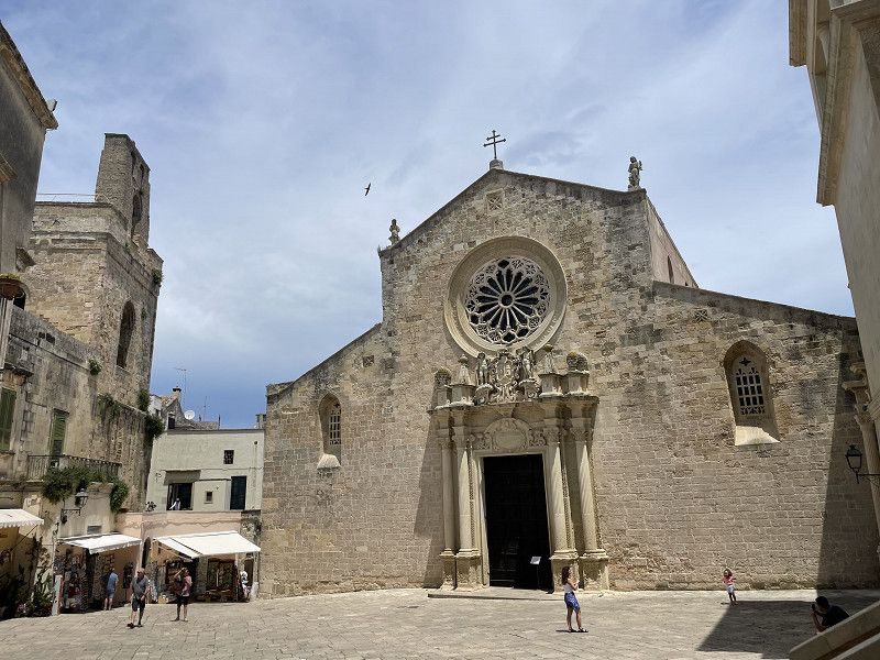
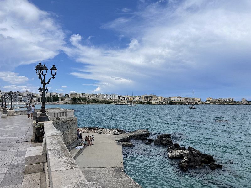
Otranto, Lecce, Italien
We chose the parking lot at the cemetery for our city tour (see park4night). It's about 15 minutes into town. Unfortunately, the church of Santa Annunziata, in which there is a floor mosaic worth seeing, was closed. We would have loved to see this. So it was only enough for a cappucino on the waterfront and a stroll through town.
73028 Otranto, Lecce, Italien
40° 8' 38" N 18° 29' 28.2" E
40.1438978 18.4911678
• Head toward Via Ottocento Martiri on Piazza Alcide De Gasperi. Go for 43 m.
• Turn sharp left onto Piazza Alcide De Gasperi. Go for 51 m.
• Turn left onto Via Guglielmotto d'Otranto. Go for 33 m.
• Continue on Via San Francesco di Paola. Go for 241 m.
• Turn left onto Via Donna Caterina. Go for 65 m.
• Turn right onto Via Giampiero Faccolli. Go for 16 m.
• Take the 2nd exit from roundabout onto Via Papa Giovanni Paolo II. Go for 345 m.
• Turn left onto Via Presbitero Pantaleone. Go for 331 m.
• Take the 1st exit from roundabout. Go for 40 m.
• Take the 1st exit from roundabout onto Via Alimini. Go for 224 m.
• Take the 2nd exit from roundabout onto Via Alimini. Go for 90 m.
• Continue on SS611. Go for 526 m.
• Continue on Strada Vicinale Masseria dei Turchi (SS611). Go for 2.3 km.
• Continue on Strada Vicinale Bonifica Alimini (SS611). Go for 2.3 km.
• Take the 1st exit from roundabout onto Strada Vicinale Bonifica Alimini (SS611). Go for 7.4 km.
• Continue on SP366. Go for 189 m.
• Take the 2nd exit from roundabout onto SP366. Go for 2.1 km.
• Turn left onto Via Mosca. Go for 243 m.
• Continue on Viale degli Eucaliptus. Go for 261 m.
• Turn right onto Via dei Platani. Go for 311 m.
• Continue on SP366. Go for 929 m.
• Turn left onto SP366. Go for 946 m.
• Arrive at SP366.
☍
19,0 km
( 22 min.)
Day
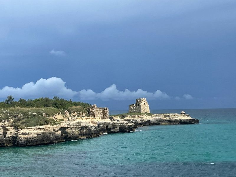
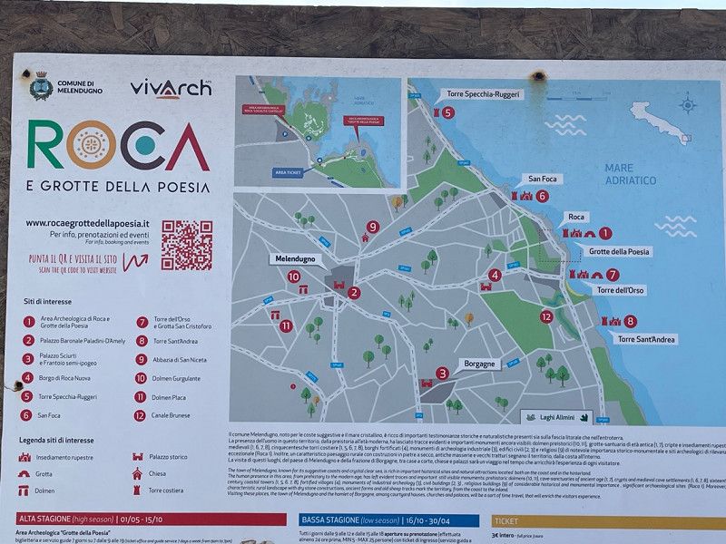
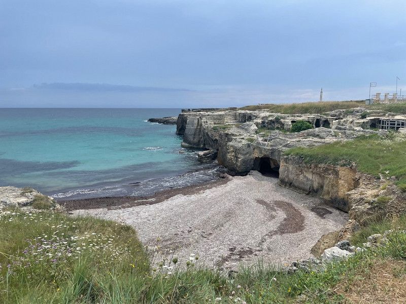
Grotta della Poesia, Roca Vecchia, Lecce, Italien
On the way to Otranto along the coast you pass a very old settlement area with great bays - the Roca e Grotte della poesia. A stop here is definitely worthwhile, even if the parking spaces for mobile homes are forbidden. We stayed here anyway because there was no other parking option.
Strada Statale San Cataldo, 73026 Roca Vecchia LE, Italien
40° 17' 9.1" N 18° 25' 46.6" E
40.2858708 18.4295973
• Head toward Via Dubrovnik on SP366. Go for 946 m.
• Turn right onto SP366. Go for 928 m.
• Continue on Via dei Platani. Go for 310 m.
• Turn right onto Viale degli Eucaliptus. Go for 692 m.
• Turn slightly right onto Via degli Eucalipts Res. Junior Due (SP297). Go for 23 m.
• Continue on SP297. Go for 377 m.
• Take the 3rd exit from roundabout onto SP297 toward Melendugno/Vernole/Lecce. Go for 2.9 km.
• Continue on Strada Comunale di Roca (SP297). Go for 3.2 km.
• Continue on SP297. Go for 251 m.
• Continue toward Circonvallazione. Go for 26 m.
• Take the 3rd exit from roundabout onto Circonvallazione toward Martano/Borgagne/Calimera. Go for 1.4 km.
• Turn left onto SP146 toward Carpignano/Martano. Go for 700 m.
• Continue on Strada Comunale Vecchia di Melendundo (SP146). Go for 2.0 km.
• Continue on Strada Vicinale Saettole (SP146). Go for 1.2 km.
• Continue on Strada Comunale Vecchia da Vernole (SP146). Go for 3.1 km.
• Continue on Strada Vicinale Grassi Mauriani (SP276). Go for 913 m.
• Take the 1st exit from roundabout onto Via San Pasquale toward Martano/Otranto. Go for 496 m.
• Take the 3rd exit from roundabout onto Strada Provinciale Martano-Otranto (SP48) toward Serrano/Cursi/Otranto. Go for 517 m.
• Take the 1st exit from roundabout onto Strada Provinciale Cursi Carpignano (SP212) toward Cursi. Go for 3.7 km.
• Continue toward Strada Provinciale Cursi Carpignano/SP212. Go for 42 m.
• Take the 2nd exit from roundabout onto Strada Provinciale Cursi Carpignano (SP212) toward Cursi. Go for 670 m.
• Take the 1st exit from roundabout onto Via L. Patrizi toward Melpignano/Novaglie. Go for 78 m.
• Keep right toward Strada Provinciale Cursi Carpignano. Go for 262 m.
• Continue on Strada Provinciale Cursi Carpignano. Go for 132 m.
• Take the 2nd exit from roundabout onto Via O. Macri toward Melpignano. Go for 454 m.
• Continue on Via Giovanni Pascoli. Go for 20 m.
• Take the 3rd exit from roundabout onto Strada Provinciale Melpignano Cursi (SP37) toward Maglie/Cursi. Go for 126 m.
• Turn right onto Via Vittorio Emanuele (SP37) toward Maglie. Go for 383 m.
• Continue on Via Maglie (SP37). Go for 384 m.
• Continue on Strada Provinciale Maglie Cursi (SP37). Go for 2.0 km.
• Take ramp onto Strada Statale Adriatica (SS16) toward S.M. di Leuca/Otranto/Maglie. Go for 1.3 km.
• Keep left onto SS275. Go for 16.5 km.
• Take the 3rd exit from roundabout onto Via della Libertà (SS275) toward Tricase. Go for 1.1 km.
• Take the 2nd exit from roundabout onto Via della Libertà (SS275) toward Miggiano/Leuca. Go for 2.8 km.
• Take the 1st exit from roundabout onto SS275. Go for 1.3 km.
• Take the 2nd exit from roundabout onto Strada Provinciale Lecce Maglie Leuca (SS275). Go for 5.8 km.
• Continue on Via Giuseppe Mazzini. Go for 92 m.
• Turn left onto Via Bari toward Leuca/Novaglie. Go for 562 m.
• Turn left onto Via Aldo Moro. Go for 41 m.
• Turn right toward Leuca/Montesardo. Go for 30 m.
• Continue on Via Piani (SS275). Go for 4.7 km.
• Pass 2 roundabouts and continue on Via della Resistenza (SS275). Go for 4.3 km.
• Keep right onto Strada Statale Salentina Meridionale (SS274) toward Presicce/Gallipoli. Go for 525 m.
• Take ramp toward Castrignano/Salignano/S.M. di Leuca. Go for 306 m.
• Turn left onto Strada Vicinale San Giuseppe Marina di Leuca (SP74). Go for 1.7 km.
• Continue on Via Enea. Go for 497 m.
• Turn left onto Via Rovigo. Go for 62 m.
• Arrive at Via Rovigo. Your destination is on the left.
☍
69,9 km
(1 hrs. 5 min.)
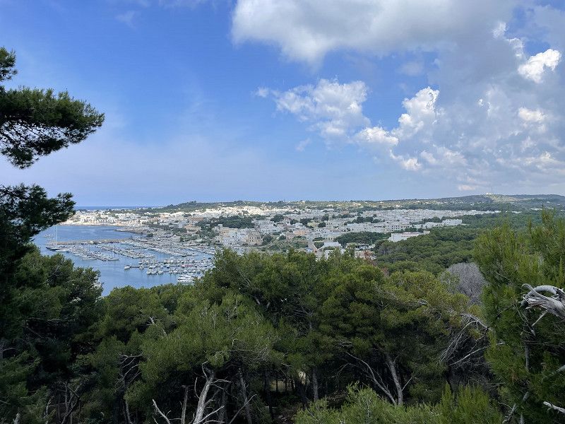
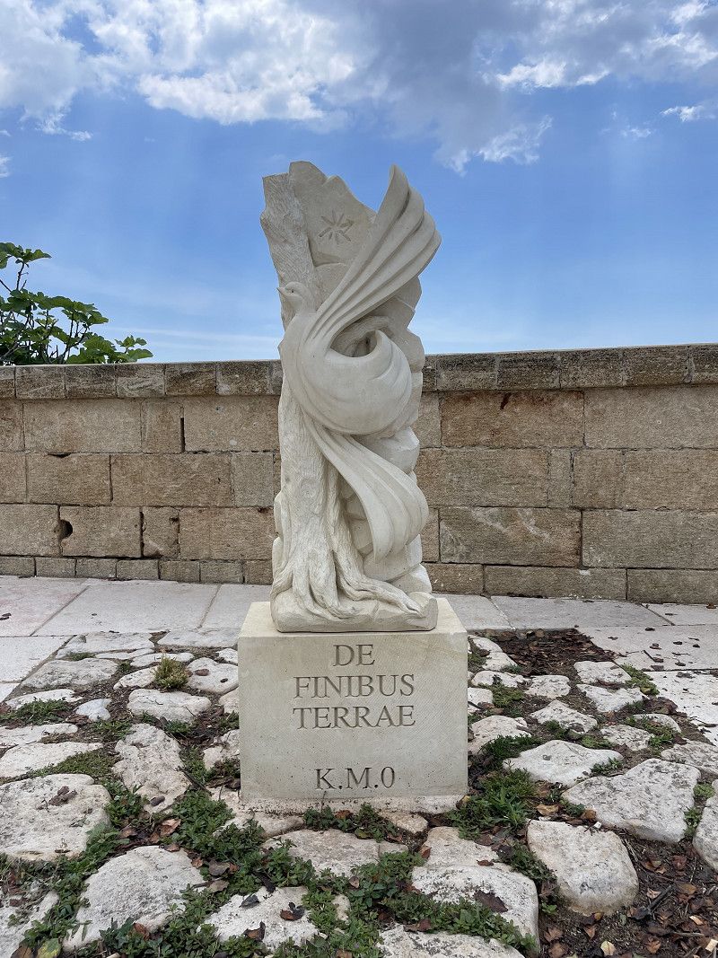
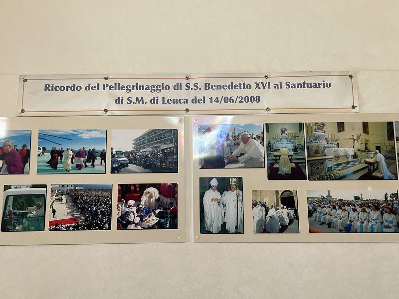
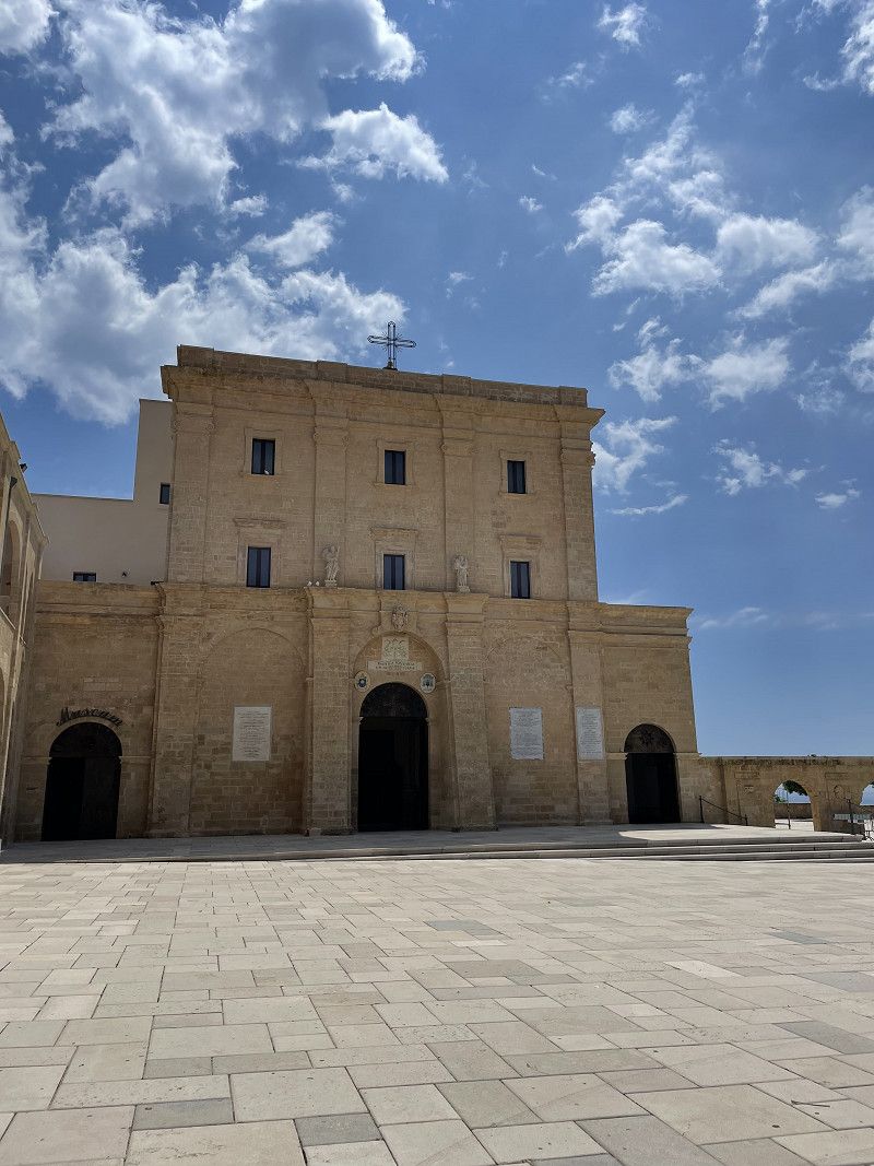
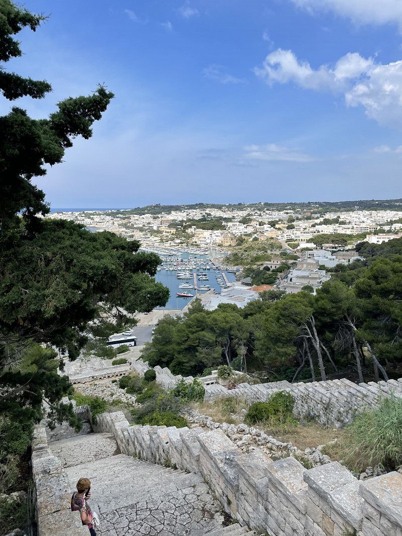
Leuca, Lecce, Italien
Santa Maria di Leuca forms the apex between the Tyrrhenian Sea and the Adriatic Sea. The Basilica of Santa Maria de Finibus Terrae dominates the city. Pope Benedict also visited the basilica.
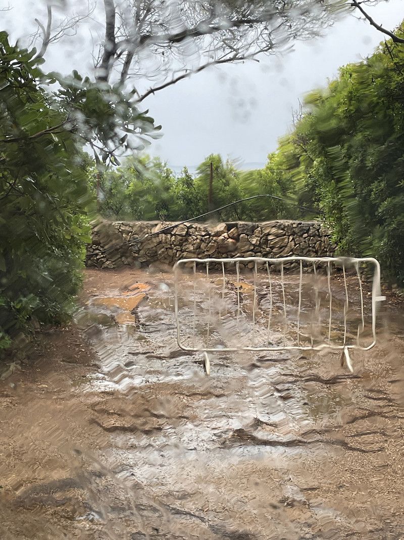
It takes about 20 minutes by bike to get to the Castell. As the weather was very bad, we only made a short visit.
73040 Santa Maria di Leuca, Lecce, Italien
39° 47' 58.2" N 18° 21' 17.7" E
39.7994998 18.3549139
• Head east on Via Rovigo. Go for 231 m.
• Turn right onto Via Virgilio. Go for 221 m.
• Continue on Via Alberto da Giussano. Go for 265 m.
• Turn left onto Via Leonardo da Vinci. Go for 246 m.
• Continue on Via Torre. Go for 216 m.
• Turn right onto Lungomare Cristoforo Colombo (SP214) toward Gallipoli. Go for 3.7 km.
• Arrive at Strada Provinciale Gallipoli Leuca (SP214). Your destination is on the right.
☍
4,9 km
( 7 min.)
Camping Paradiso
A campsite like a jungle! With a lot of love and time, the owner has created a wonderful Mediterranean flora, with walking paths and individually designed corners. On hot days it is definitely a relief to stay here. Unfortunately it rained here and in this weather you long for every ray of sunshine. The mosquitoes also annoyed us quite a bit. But the place can't do anything about it. We spent two nights here for 27€/N including electricity and tourist tax.
SP91, 27, 73040 Marina di Felloniche LE, Italien
39° 48' 38.6" N 18° 19' 17.1" E
39.8107356 18.3214249
• Head toward Via Volito 2 on Strada Provinciale Gallipoli Leuca (SP214). Go for 863 m.
• Continue toward Via Patù/SP192. Go for 40 m.
• Take the 1st exit from roundabout onto Via Patù (SP192). Go for 2.1 km.
• Take ramp onto Strada Statale Salentina Meridionale (SS274) toward Presicce/Gallipoli. Go for 12.3 km.
• Take the 3rd exit from roundabout onto Strada Statale Salentina Meridionale (SS274) toward Gallipoli/Ugento. Go for 24.5 km.
• Take ramp toward Gallipoli. Go for 877 m.
• Continue toward Strada Statale Gallipoli-Alezio. Go for 45 m.
• Take the 1st exit from roundabout onto Strada Statale Gallipoli-Alezio toward Gallipoli. Go for 2.3 km.
• Take the 4th exit from roundabout onto Corso Capo di Leuca toward Centro. Go for 321 m.
• Continue toward Piazza Salento. Go for 11 m.
• Arrive at Piazza Salento. Your destination is on the left.
☍
43,4 km
( 31 min.)
Day
Day
Gallipoli, Lecce, Italien
Only as a waypoint
73014 Gallipoli, Lecce, Italien
40° 3' 21.1" N 17° 59' 33.4" E
40.0558508 17.9926137
• Head toward Corso Capo di Leuca on Via Lecce. Go for 11 m.
• Turn left onto Via Lecce. Go for 1.6 km.
• Continue toward Via Lecce. Go for 37 m.
• Take the 2nd exit from roundabout onto Via Lecce toward Lecce. Go for 950 m.
• Take ramp onto SS101 toward Lecce. Go for 32.1 km.
• Keep right toward Tangenziale/Brindisi/SS613/Maglie/SS16/Leuca. Go for 103 m.
• Take ramp onto Tangenziale Ovest di Lecce toward Brindisi. Go for 7.3 km.
• Continue on Tangenziale Est di Lecce. Go for 222 m.
• Take ramp toward Brindisi. Go for 294 m.
• Turn right onto SS613. Go for 33.0 km.
• Keep left onto Strada Statale Adriatica (SS16) toward Bari. Go for 2.2 km.
• Take ramp toward Ospedale A. Perrino/Brindisi Centro/Taranto-Mesagne/Taranto. Go for 429 m.
• Take the 5th exit from roundabout onto Via Appia (SS7) toward Taranto. Go for 66.1 km.
• Keep left onto Strada Statale del Porto di Taranto (SS689). Go for 400 m.
• Take ramp onto Strada Statale Jonica (SS106) toward Reggio C. Go for 36.7 km.
• Take ramp toward C. da Pantano/SP105/Ginosa/SS580. Go for 119 m.
• Turn left toward Ginosa. Go for 76 m.
• Turn left onto Contrada Pantano (SP2). Go for 201 m.
• Turn left toward Taranto. Go for 101 m.
• Continue toward Via Lungogalaso. Go for 390 m.
• Turn right onto Via Lungogalaso. Go for 3.8 km.
• Turn sharp right onto Contrada Marinella. Go for 306 m.
• Continue on Contrada Marinella. Go for 1.0 km.
• Turn left toward Contrada Torre Mattone. Go for 91 m.
• Turn right onto Contrada Torre Mattone. Go for 52 m.
• Arrive at Contrada Torre Mattone.
☍
187,7 km
(1 hrs. 53 min.)
Area Amici della Nature
If you like nature and simplicity, this is the place for you. It is about 200m to the beach. For €15/N without electricity (€5) you can unwind here. Only in the evenings is it a bit louder from the neighboring resort. At 11 p.m. the spook is over.
The driveway is a bit adventurous. The last kilometer is unpaved.
Marinella-Torre mattoni, 74013, Marina di Ginosa, Italien
40° 24' 21" N 16° 51' 57" E
40.4058333 16.8658333
• Head toward Contrada Marinella on Contrada Torre Mattone. Go for 52 m.
• Turn left toward Contrada Marinella. Go for 91 m.
• Turn right onto Contrada Marinella. Go for 1.0 km.
• Continue on Contrada Marinella. Go for 288 m.
• Turn sharp left onto Via Lungogalaso. Go for 3.8 km.
• Turn left toward Reggio C. Go for 358 m.
• Take ramp onto Strada Statale Jonica (SS106) toward Taranto. Go for 3.5 km.
• Take ramp toward Ginosa. Go for 135 m.
• Turn left toward SS580. Go for 91 m.
• Turn left onto SS580. Go for 15.2 km.
• Take the 1st exit from roundabout onto SS580. Go for 444 m.
• Take the 1st exit from roundabout toward Laterza/Centro. Go for 57 m.
• Continue on SS580. Go for 9 m.
• Continue on Via Giacomo Matteotti (SS580). Go for 143 m.
• Turn right onto Via Cavese (SP7). Go for 431 m.
• Continue on SP7. Go for 647 m.
• Turn left toward Strada Statale di Ginosa/SS580. Go for 3.8 km.
• Turn right onto Strada Statale di Ginosa (SS580) toward Bari/Autostrada/Castellaneta/Laterza. Go for 4.3 km.
• Take the 2nd exit from roundabout onto Strada Provinciale Laterza C. da Alvino (SP6) toward San Falco. Go for 414 m.
• Turn right toward Via Giuseppe Montrone. Go for 123 m.
• Turn right onto Via Giuseppe Montrone. Go for 310 m.
• Continue on Via Mater Domini. Go for 276 m.
• Continue on Via Corte Moscati. Go for 5 m.
• Turn right onto Via Dante Alighieri. Go for 191 m.
• Continue on Via Roma (SPEXSS7). Go for 67 m.
• Continue on Via Giannone (SP15) toward Autostrade. Go for 172 m.
• Turn right onto Via Selva San Vito (SP15). Go for 1.0 km.
• Turn right onto Strada Comunale 49. Go for 256 m.
• Turn right. Go for 9 m.
• Arrive at your destination.
☍
37,1 km
( 38 min.)
Day
Day
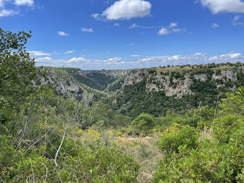
Gravina di Laterza, Via Chiesa, Laterza, Tarent, Italien
You can park directly at the ranger station. There is also information about hiking opportunities here.
The path passes above the gorge and offers great views of it.
Via Selva S. Vito, Via Chiesa, 74014 Laterza TA, Italien
40° 36' 59.6" N 16° 48' 35.4" E
40.6165542 16.8098250
• Head toward Contrada Selva San Vito Parallela 1. Go for 9 m.
• Turn left onto Strada Comunale 49. Go for 256 m.
• Turn left onto Via Selva San Vito (SP15dir). Go for 1.0 km.
• Turn right onto Piazzale Giuseppe Saragat. Go for 43 m.
• Turn left toward Via Monte Ortigara. Go for 11 m.
• Continue on Via Monte Ortigara. Go for 50 m.
• Turn left onto Via Vittorio Veneto. Go for 170 m.
• Continue on Via Porta Pia. Go for 200 m.
• Continue on Via Dogali. Go for 27 m.
• Turn right onto Via Lecce. Go for 66 m.
• Turn slightly left onto Via Carnia. Go for 135 m.
• Turn right onto Via Matera. Go for 5.0 km.
• Take left ramp onto Via Appia (SS7) toward Matera. Go for 11.6 km.
• Turn left onto Contrada Murgia Timone. Go for 965 m.
• Turn slightly left onto Contrada Murgia Timone. Go for 308 m.
• Arrive at Contrada Murgia Timone. Your destination is on the left.
☍
19,8 km
( 22 min.)
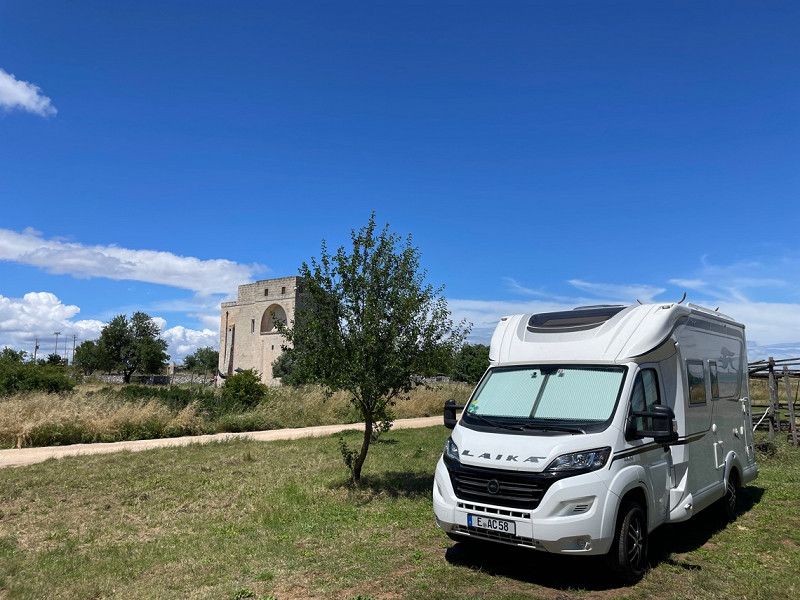
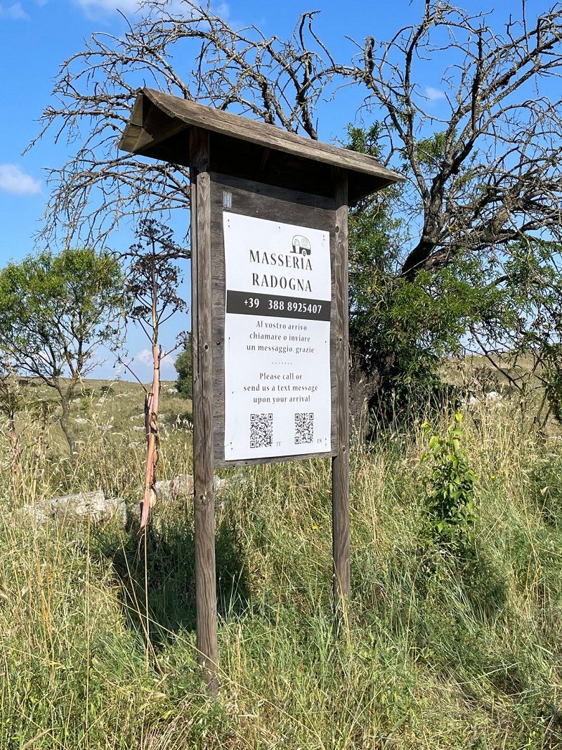
Stellplatz Masseria Rodogna
Very nice parking space behind the archaeological station parking lot. The overnight price of €23 (without electricity) includes the transfer to Matera. A very convenient solution that we were happy to take advantage of.
The next morning we walked a little further along the footpath to Matera. Unfortunately, due to previous rain, the entire path was closed.
Parco Archeologico Storico Naturale delle Chiese Rupestri del Materano
40° 40' 15.9" N 16° 37' 49" E
40.6710708 16.6302646
• Head northwest on Contrada Murgia Timone. Go for 1.3 km.
• Turn left onto Via Appia (SS7). Go for 2.6 km.
• Take the 3rd exit from roundabout onto Via San Vito. Go for 798 m.
• Continue on Via Guglielmo Marconi. Go for 561 m.
• Continue on Via Annunziatella. Go for 391 m.
• Take the 2nd exit from roundabout onto Via 20 Settembre. Go for 216 m.
• Continue on Via Lucana. Go for 227 m.
• Turn right onto Via Roma. Go for 30 m.
• Turn left onto Via Don Minzoni Vico 1. Go for 81 m.
• Turn left onto Via Don Giovanni Minzoni. Go for 21 m.
• Arrive at Via Don Giovanni Minzoni. Your destination is on the right.
☍
6,2 km
( 12 min.)
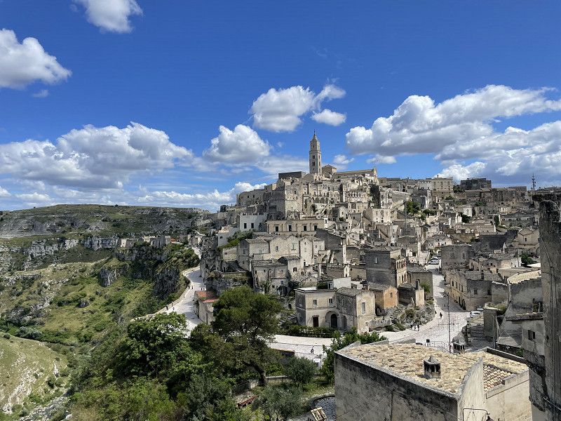
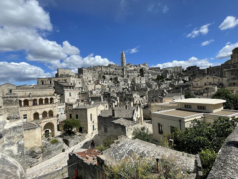
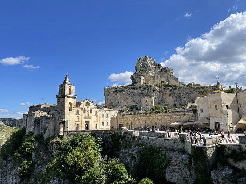
Matera, Italien
Matera is one of the oldest cities in the world. Until 1950, the cave dwellings, the so-called Sassi di Matera, were used as dwellings. These are now part of the UNESCO World Heritage.
The visit to the city and a short hike on the opposite plateau were definitely among the highlights of our tour of Italy.
75100 Matera, Italien
40° 39' 59" N 16° 36' 15.6" E
40.6663790 16.6043199
• Head southeast on Via Don Giovanni Minzoni. Go for 13 m.
• Turn right onto Piazza del Mulino. Go for 165 m.
• Turn right onto Via Gerardo Guerrieri. Go for 109 m.
• Turn left onto Piazza Giacomo Matteotti. Go for 12 m.
• Turn right onto Piazza Giacomo Matteotti. Go for 62 m.
• Take the 4th exit from roundabout onto Viale Aldo Moro. Go for 407 m.
• Take the 3rd exit from roundabout onto Via Timmari. Go for 2.3 km.
• Continue on Contrada Pozzo Misseo. Go for 23 m.
• Turn left toward Metaponto/SP3/Potenza/SS407. Go for 188 m.
• Take ramp toward Potenza/SS407/Metaponto. Go for 36 m.
• Take the 1st exit from roundabout. Go for 123 m.
• Continue on Via Appia (SS7). Go for 7.9 km.
• Take ramp onto Strada Statale dei Tre Confini (SP3) toward Bernalda/Jonica/SS106/Metaponto/Montescaglioso. Go for 33.1 km.
• Take ramp onto Strada Statale Jonica (SS106) toward Reggio C. Go for 84.3 km.
• Continue on SS106radd. Go for 2.1 km.
• Keep left onto SS106radd. toward Reggio Calabria/Catanzaro/Corigliano C./Cosenza/Rossano/Calabro. Go for 6.3 km.
• Turn left onto Via Zona Industriale. Go for 1.1 km.
• Turn right. Go for 364 m.
• Turn left. Go for 502 m.
• Arrive at your destination on the left.
☍
139,1 km
(1 hrs. 43 min.)
Day
Village Camping Due Elle
10% discount on ACSI card. Lots of free-roaming dogs in the area and lots of Italian flair. Typical animation for a Camping Village pitch. We moved on after a restless night.
S. S. 106 BIS C\ da Concio Vecchio 0983851160, 87064, Corigliano Rossano, Italien
39° 40' 34.7" N 16° 31' 25.9" E
39.6763000 16.5238500
• Head south. Go for 502 m.
• Turn right toward Via Zona Industriale. Go for 364 m.
• Turn left onto Via Zona Industriale. Go for 1.1 km.
• Turn right onto SS106radd. Go for 8.4 km.
• Continue on SS106. Go for 2.4 km.
• Take ramp toward Sibari/Cassano J. Go for 105 m.
• Keep left toward SS106r. Go for 30 m.
• Turn left onto SS106r. Go for 2.1 km.
• Turn right. Go for 49 m.
• Turn right toward Contrada Fuscolara. Go for 173 m.
• Turn left onto Contrada Fuscolara. Go for 517 m.
• Arrive at Contrada Fuscolara. Your destination is on the left.
☍
15,7 km
( 18 min.)
Day
Campeggio Pineta di Sibari
Place with lots of pine trees and super friendly reception. We had a place right by the sea. With ACSI 21€/N, this place is highly recommended.
s.s.IONICA 106 km 372,2 , 87011, Sibari, Italien
39° 46' 47.2" N 16° 28' 46" E
39.7797800 16.4794500
• Head west on Contrada Fuscolara. Go for 517 m.
• Turn right. Go for 173 m.
• Turn left toward SS106r. Go for 49 m.
• Turn right onto SS106r. Go for 407 m.
• Continue on Viale Goffredo Mameli (SS106r). Go for 766 m.
• Take the 3rd exit from roundabout onto Strada Statale dell'Appennino Meridionale (SS92). Go for 6.6 km.
• Turn right onto SS92. Go for 858 m.
• Continue on Contrada Piano del Praino (SS92). Go for 551 m.
• Continue on SS92. Go for 270 m.
• Continue toward SS92. Go for 383 m.
• Turn left onto SS92. Go for 1.6 km.
• Turn right onto Contrada Balzo di Cristo. Go for 633 m.
• Turn right onto Contrada Balzo di Cristo. Go for 145 m.
• Arrive at Contrada Balzo di Cristo. Your destination is on the left.
☍
12,9 km
( 18 min.)
Day
Day
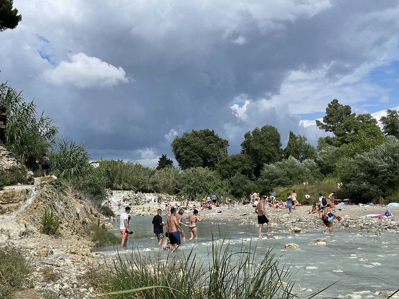
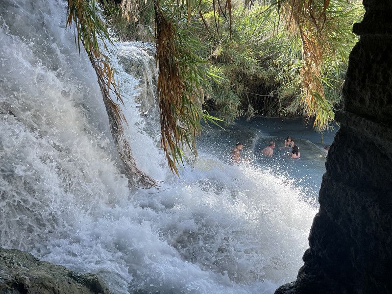
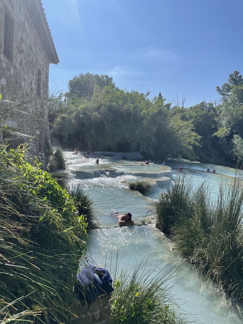
Grotta Delle Ninfe, Cerchiara Calabra, Cerchiara di Calabria, Cosenza, Italien
During a bike tour we approached this grotto. Unfortunately, the grotto itself could not be visited, but you could enjoy the hot sulfur water including a mud pack in the outdoor pool in front of it.
87070 Cerchiara di Calabria, Cosenza, Italien
39° 50' 27.6" N 16° 24' 9.6" E
39.8409994 16.4026707
• Head southeast on Contrada Balzo di Cristo. Go for 145 m.
• Turn left onto Contrada Balzo di Cristo. Go for 633 m.
• Turn left onto SS92. Go for 1.6 km.
• Turn right toward SS92. Go for 383 m.
• Continue on SS92. Go for 270 m.
• Continue on Contrada Piano del Praino (SS92). Go for 551 m.
• Continue on SS92. Go for 858 m.
• Turn left onto Via Nazionale (SS92). Go for 6.6 km.
• Take the 1st exit from roundabout onto Viale Goffredo Mameli (SS106r). Go for 785 m.
• Continue on SS106r. Go for 407 m.
• Turn left. Go for 49 m.
• Turn right toward Contrada Fuscolara. Go for 173 m.
• Turn left onto Contrada Fuscolara. Go for 517 m.
• Arrive at Contrada Fuscolara. Your destination is on the left.
☍
12,9 km
( 18 min.)
Day
Campeggio Pineta di Sibari
s.s.IONICA 106 km 372,2 , 87011, Sibari, Italien
39° 46' 47.2" N 16° 28' 46" E
39.7797800 16.4794500
• Head west on Contrada Fuscolara. Go for 517 m.
• Turn right. Go for 173 m.
• Turn left toward SS106r. Go for 49 m.
• Turn left onto SS106r. Go for 1.8 km.
• Turn right onto SP161. Go for 213 m.
• Take left ramp onto SS106. Go for 2.8 km.
• Continue on SS106radd. Go for 2.1 km.
• Keep left onto SS106radd. toward Reggio Calabria/Catanzaro/Corigliano C./Cosenza/Rossano/Calabro. Go for 9.5 km.
• Pass 15 roundabouts and continue on Contrada Ferraina (SS106). Go for 64.6 km.
• Take ramp toward Cirò M. Nord. Go for 150 m.
• Turn left onto Via Salvogaro (SP2). Go for 123 m.
• Turn right onto Via Madonna di Mare (SP5). Go for 37 m.
• Turn left onto Via Tirone (SP5). Go for 1.1 km.
• Continue on Via Giuseppe Garibaldi (SP5). Go for 143 m.
• Take the 3rd exit from roundabout onto Via Santa Croce. Go for 830 m.
• Turn right onto Via Scalaretto. Go for 76 m.
• Turn left onto Via Scalaretto. Go for 582 m.
• Continue on Località Punta Alice. Go for 1.2 km.
• Turn right toward Via del Faro. Go for 111 m.
• Continue on Via del Faro. Go for 1.6 km.
• Arrive at your destination.
☍
87,7 km
(1 hrs. 32 min.)
Day
Punta Alice, Cirò Marina, Crotone, Italien
We made a stop here on our tour to Crotone. A great view of a small church, where there is also a stop. Unfortunately this was closed.
88811 Cirò Marina, Crotone, Italien
39° 24' 4.1" N 17° 9' 21.6" E
39.4011428 17.1559946
• Head west. Go for 1.4 km.
• Continue on Via del Faro. Go for 361 m.
• Turn left onto Località Punta Alice. Go for 1.2 km.
• Continue on Via Scalaretto. Go for 582 m.
• Turn right onto Via Scalaretto. Go for 74 m.
• Turn right onto Via Scalaretto. Go for 7 m.
• Turn left onto Via Scalaretto. Go for 806 m.
• Take the 1st exit from roundabout onto Via Giuseppe Garibaldi (SP5). Go for 156 m.
• Continue on Via Tirone (SP5). Go for 1.1 km.
• Turn right onto Via Madonna di Mare (SP5). Go for 37 m.
• Turn left onto Via Salvogaro (SP2). Go for 123 m.
• Turn left and take ramp onto SS106 toward Catanzaro/Reggio Calabria/Crotone. Go for 2.2 km.
• Pass 4 roundabouts and continue on Contrada Gangemi (SS106). Go for 14.7 km.
• Continue straight ahead. Go for 63 m.
• Take the 2nd exit from roundabout toward Crotone/Reggio C. Go for 93 m.
• Continue on Contrada Frasso. Go for 36 m.
• Keep right onto SS106 toward S. Nicola/Strongoli/Savelli/Verzino/Casabona/Pallagorio/Crotone. Go for 7.3 km.
• Take the 3rd exit from roundabout onto SS106. Go for 5.3 km.
• Take left ramp onto Strada Statale Silana Crotonese (SS107) toward Crotone/SS106. Go for 1.3 km.
• Take the 2nd exit from roundabout onto SS106 toward Reggio Cal./Catanzaro/Crotone Centro. Go for 3.2 km.
• Take ramp onto SS106bis toward Crotone Centro. Go for 281 m.
• Continue on Strada Consorziale (SS106bis). Go for 846 m.
• Take the 2nd exit from roundabout onto Strada Consorziale (SS106bis). Go for 785 m.
• Take the 1st exit from Largo G. Covelli roundabout onto Via Claudio Crea. Go for 386 m.
• Continue on Corso Giuseppe Mazzini. Go for 64 m.
• Keep left onto Corso Giuseppe Mazzini. Go for 66 m.
• Pass 2 roundabouts and continue on Corso Giuseppe Mazzini. Go for 858 m.
• Take the 2nd exit from Piazza Maestri del Lavoro roundabout onto Viale Leonardo Gallucci. Go for 935 m.
• Turn right onto Viale Antonio Gramsci. Go for 322 m.
• Take the 2nd exit from roundabout onto Viale Antonio Gramsci (SP49). Go for 688 m.
• Continue on Viale Magna Grecia (SP49). Go for 2.5 km.
• Continue on Via Capo Colonna (SP49). Go for 2.1 km.
• Turn left onto Via Lacinio. Go for 2.3 km.
• Turn left onto Via Hera Lacinia (SP49). Go for 476 m.
• Turn right onto Via Achille (SP49). Go for 195 m.
• Arrive at Via Achille (SP49). Your destination is on the right.
☍
52,8 km
(1 hrs. 6 min.)
Capo Colonna, Crotone, Italien
The easternmost point of Calabria. We only drove to this one briefly
88900 Capo Colonna, Crotone, Italien
39° 1' 22.4" N 17° 11' 51.2" E
39.0228796 17.1975669
• Head toward Via Hera Lacinia on Via Achille (SP49). Go for 195 m.
• Turn left onto Via Hera Lacinia (SP49). Go for 2.1 km.
• Turn right onto Via Capo Colonna (SP49). Go for 3.0 km.
• Continue on Viale Magna Grecia (SP49). Go for 2.5 km.
• Continue on Viale Antonio Gramsci (SP49). Go for 659 m.
• Take the 1st exit from roundabout onto Viale Antonio Gramsci. Go for 349 m.
• Turn left onto Viale Leonardo Gallucci. Go for 929 m.
• Take the 2nd exit from Piazza Maestri del Lavoro roundabout onto Corso Giuseppe Mazzini. Go for 248 m.
• Pass 2 roundabouts and continue on Corso Giuseppe Mazzini. Go for 724 m.
• Continue on Via Claudio Crea. Go for 22 m.
• Turn left onto Via Mario Nicoletta. Go for 239 m.
• Arrive at Via Mario Nicoletta. Your destination is on the left.
☍
11,0 km
( 19 min.)
Campeggio Alfier
Great located CP right on the beach. Very friendly family running this place. You can even talk to the lady of the house in German.
For €25/N including electricity, it was totally fine.
Loc Alfieri, 88900, Crotone, Italien
39° 4' 53.5" N 17° 7' 13.9" E
39.0815200 17.1205400
• Head west on Via Mario Nicoletta. Go for 138 m.
• Turn left onto Via 25 Aprile. Go for 201 m.
• Take the 1st exit from Piazza Francesco Corrado roundabout onto Piazzale Milone. Go for 436 m.
• Take the 2nd exit from Piazza Antonio Caputi roundabout onto Via Giovanni Paolo II. Go for 1.4 km.
• Take the 1st exit from roundabout onto Via Giovanni Paolo II. Go for 928 m.
• Take ramp. Go for 194 m.
• Take left ramp onto SS106. Go for 687 m.
• Pass 5 roundabouts and continue on SS106. Go for 19.7 km.
• Take ramp. Go for 733 m.
• Take the 2nd exit from roundabout onto SP44. Go for 1.9 km.
• Continue on Strada Comunale Le Castella. Go for 94 m.
• Take the 2nd exit from roundabout onto Strada Comunale Le Castella. Go for 129 m.
• Continue on Via Duomo. Go for 359 m.
• Turn left onto Via A. M. Rigon. Go for 34 m.
• Arrive at Via A. M. Rigon.
☍
27,0 km
( 26 min.)
Day
Le Castella, Crotone, Italien
A very beautiful touristic coastal town with an imposing castle. Here you can watch the hustle and bustle in nice cafes and enjoy a great sunset.
88841 Le Castella, Crotone, Italien
38° 54' 32.9" N 17° 1' 23" E
38.9091383 17.0230494
• Head toward Via Uccialì on Via A. M. Rigon. Go for 122 m.
• Turn right onto Via Annibale Barca. Go for 57 m.
• Turn left onto Via Marco Polo. Go for 117 m.
• Turn right onto Via Fosso. Go for 57 m.
• Take the 2nd exit from roundabout onto Largo Ferdinando Magellano. Go for 85 m.
• Turn right onto Belvedere Ferdinando Magellano. Go for 44 m.
• Continue on Via della Darsena. Go for 95 m.
• Turn left onto Via Alberto Moravia. Go for 238 m.
• Turn right onto Strada Comunale Le Castella. Go for 35 m.
• Take the 1st exit from roundabout onto Strada Comunale Le Castella. Go for 116 m.
• Turn right onto Strada Comunale Le Castella. Go for 203 m.
• Turn right onto Località Santa Domenica. Go for 117 m.
• Arrive at Località Santa Domenica. Your destination is on the right.
☍
1,3 km
( 3 min.)
Camping Costa Splendente sul mare
Very nice campsite under eucalyptus trees. It takes about 10 minutes to walk to town. For 15€/N an absolute snapper.
Frazione Le Castella, 88841, Isola di Capo Rizzuto, Italien
38° 54' 55.5" N 17° 1' 41.2" E
38.9154100 17.0281200
• Head southwest on Località Santa Domenica. Go for 117 m.
• Turn left onto Strada Comunale Le Castella. Go for 173 m.
• Turn left toward SP44. Go for 48 m.
• Continue on Strada Comunale Le Castella. Go for 94 m.
• Take the 1st exit from roundabout onto Località Volandrino (SP43). Go for 2.8 km.
• Take the 3rd exit from roundabout onto SS106 toward Catanzaro. Go for 1.8 km.
• Pass 7 roundabouts and continue on Via Nazionale (SS106). Go for 30.7 km.
• Take the 1st exit from roundabout onto SP16 toward Salerno-Reggio C./A3/Catanzaro/Reggio C./SS106var/A. Go for 980 m.
• Take ramp toward Reggio C./SS106var/A/SA-RC/A3/Aeroporto. Go for 532 m.
• Continue on SS106var/A. Go for 7.8 km.
• Take ramp toward Salerno/A3/Reggio C./Catanzaro Ovest. Go for 572 m.
• Take ramp onto Strada Statale di Germaneto (SS280dir) toward Catanzaro Ovest/Salerno Reggio Calabria/A3. Go for 4.6 km.
• Take left ramp onto SS280 toward SA-RC/A3/Caraffa/Lamezia T. Go for 27.9 km.
• Take ramp onto A2 (Autostrada del Mediterraneo) toward Salerno/Reggio C./Reggio Calabria. Go for 18.9 km.
• Take the exit toward Pizzo Calabro/Pizzo/Tropea/Reggio C./Vibo Valentia. Go for 697 m.
• Continue on Strada Statale Tirrena Inferiore (SS18). Go for 557 m.
• Turn right onto Via Riviera Prangi (SS522) toward Pizzo/Parghelia/Zambrone/Tropea. Go for 5.1 km.
• Arrive at Via Riviera Prangi (SS522).
☍
103,4 km
(1 hrs. 20 min.)
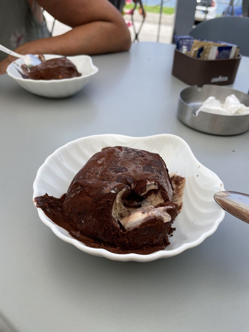
Piedigrotta-Kirche, Via Riviera Prangi, Pizzo, Vibo Valentia, Italien
About a kilometer from the historic center of Vibo is the rock church Piedigrotta. Stairs leading to the church from the parking lot offer a great view of the sea. Divided into three rooms, the grotto houses a series of statues depicting the life of Jesus and the saints.
But the hit in Vigo is the Tartuffo ice cream. Directly opposite the parking lot is a bar where you can enjoy the local specialty.
Località Madonnella, Via Riviera Prangi, SS522, 89812 Pizzo VV, Italien
38° 44' 31.8" N 16° 10' 29.6" E
38.7421544 16.1749019
• Head southwest on Via Riviera Prangi (SS522). Go for 884 m.
• Turn right onto Via Marcello Salomone (SS522). Go for 749 m.
• Continue on Via Antonino Anile (SS522). Go for 813 m.
• Continue on SS522. Go for 904 m.
• Continue on Contrada Mondello (SS522). Go for 1.3 km.
• Continue on SS522. Go for 339 m.
• Continue on Via Pizzo (SS522). Go for 332 m.
• Turn left onto Via Longobardi (SS522). Go for 470 m.
• Continue on SS522. Go for 3.7 km.
• Pass 4 roundabouts and continue on SS522. Go for 17.7 km.
• Turn right onto Contrada Cervo Sant'Antonio. Go for 64 m.
• Turn left onto Strada Cervo Sant'Antonio. Go for 571 m.
• Continue on Contrada La Grazia. Go for 195 m.
• Turn right onto Contrada Marina Vescovado. Go for 279 m.
• Turn slightly left onto Contrada Marina Vescovado. Go for 470 m.
• Turn right onto Contrada Marina Vescovado. Go for 55 m.
• Turn left onto Contrada Marina Vescovado. Go for 38 m.
• Turn right toward Via Marina dell'Isola. Go for 12 m.
• Turn slightly left onto Via Marina dell'Isola. Go for 473 m.
• Turn right. Go for 57 m.
• Turn right. Go for 26 m.
• Turn left. Go for 22 m.
• Arrive at your destination on the left.
☍
29,4 km
( 38 min.)
Day
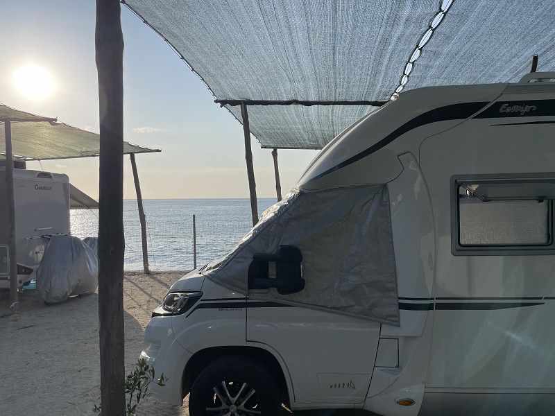
Camping Marina dell'Isola
An ACSI place where we stayed for €22 including tourist tax. From here a stairway leads directly to the city center of Tropea. The beach in front of the CP is quite small and was paved over with sunbeds and umbrellas for rent during our stay.
The sea is a force, but many other people also appreciate it, so that there is quite a tourist hype.
From the port you can go to the Aeolian Islands. The trip to Stromboli was supposed to cost 60€/P, but according to our impression it was no more than a coffee trip. We then enjoyed the view of the volcano from the CP.
Marina dell'Isola (Lungomare Sorrentino), 89861, Tropea, Italien
38° 40' 45.4" N 15° 53' 41.5" E
38.6792800 15.8948500
• Head east. Go for 22 m.
• Turn right. Go for 26 m.
• Turn right toward Via Marina dell'Isola. Go for 81 m.
• Turn right onto Via Marina dell'Isola. Go for 561 m.
• Continue on Via Marina del Convento. Go for 761 m.
• Turn left onto Viale Don Mottola (SP20). Go for 896 m.
• Turn slightly right onto Via Libertà. Go for 55 m.
• Turn right onto Via Margherita di Savoia. Go for 130 m.
• Turn right onto Largo San Michele. Go for 37 m.
• Turn right onto Via Umberto I. Go for 10 m.
• Arrive at Via Umberto I.
☍
2,6 km
( 7 min.)
Day
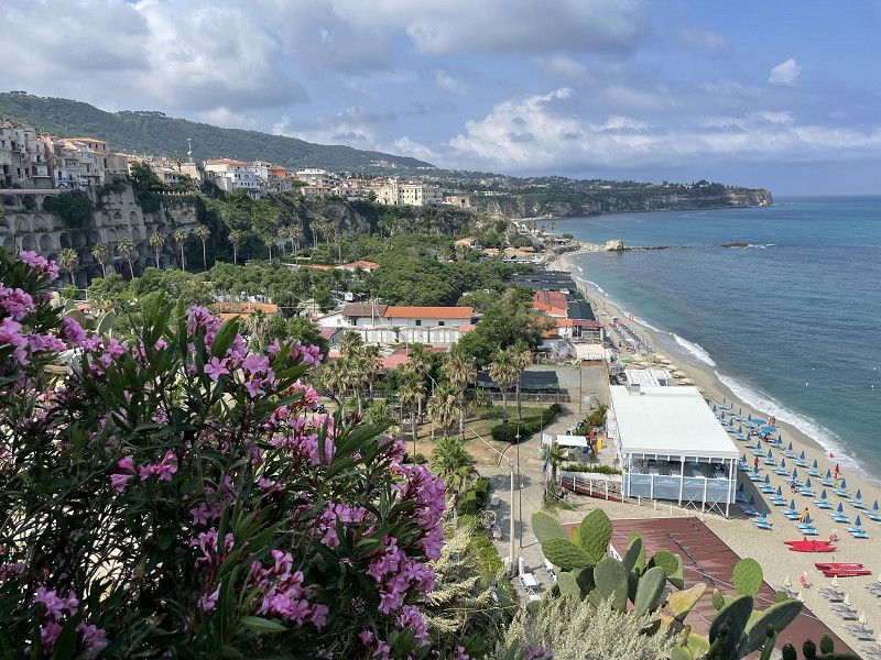
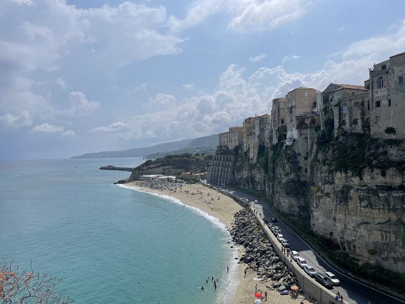
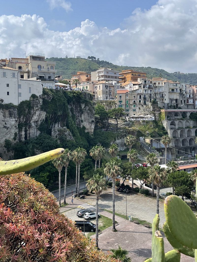
Tropea, Vibo Valentia, Italien
Tropea is one of the most beautiful places to swim in Calabria. The place itself is a typical Calabrian place with narrow streets and great vantage points of the adjacent sea.
89861 Tropea, Vibo Valentia, Italien
38° 40' 37.2" N 15° 53' 50" E
38.6769938 15.8972233
• Head toward Via Libertà on Via Umberto I. Go for 154 m.
• Turn right onto Via Libertà. Go for 25 m.
• Turn right onto Via Margherita di Savoia. Go for 130 m.
• Turn right onto Largo San Michele. Go for 23 m.
• Turn left onto Discesa Belisario. Go for 614 m.
• Turn left toward Via Marina dell'Isola. Go for 12 m.
• Turn slightly left onto Via Marina dell'Isola. Go for 473 m.
• Turn right. Go for 57 m.
• Turn right. Go for 26 m.
• Turn left. Go for 22 m.
• Arrive at your destination on the left.
☍
1,5 km
( 4 min.)
Day
Camping Marina dell'Isola
Marina dell'Isola (Lungomare Sorrentino), 89861, Tropea, Italien
38° 40' 45.4" N 15° 53' 41.5" E
38.6792800 15.8948500
• Head east. Go for 22 m.
• Turn right. Go for 26 m.
• Turn right toward Via Marina dell'Isola. Go for 81 m.
• Turn right onto Via Marina dell'Isola. Go for 561 m.
• Continue on Via Marina del Convento. Go for 761 m.
• Turn right onto Viale Don Mottola (SP20). Go for 861 m.
• Take the 4th exit from roundabout onto SS522. Go for 113 m.
• Take the 2nd exit from roundabout onto SS522. Go for 748 m.
• Continue on Galleria Sant'Angelo (SS522). Go for 554 m.
• Continue on SS522. Go for 1.6 km.
• Take the 1st exit from roundabout onto SS522. Go for 11.9 km.
• Take the 2nd exit from roundabout onto SS522. Go for 2.5 km.
• Take the 2nd exit from roundabout onto SS522. Go for 2.4 km.
• Continue toward Via Nazionale/SS522. Go for 41 m.
• Take the 2nd exit from roundabout onto Via Nazionale (SS522). Go for 1.2 km.
• Take the 2nd exit from roundabout onto Via Casello Fs (SS522). Go for 3.2 km.
• Take ramp onto SS182 toward Salerno/A3/Reggio Calabria/Aeroporto/Vibo Valentia. Go for 4.5 km.
• Turn left onto Strada Statale Tirrena Inferiore (SS18). Go for 9.6 km.
• Take left ramp onto A2 (Autostrada del Mediterraneo) toward Salerno. Go for 52.4 km.
• Take the exit toward Altilia/Grimaldi. Go for 544 m.
• Continue on SS616 toward Maione/Altilia/Grimaldi/Malito/Aiello Calabro. Go for 3.0 km.
• Turn left onto SP57. Go for 5.1 km.
• Continue on SS108. Go for 12.0 km.
• Turn left onto Via Piano Lago (SP241). Go for 8.1 km.
• Turn left onto Contrada Bivio Donnici (SP241). Go for 4.5 km.
• Turn right onto Via Donato Morelli (SP241). Go for 944 m.
• Take the 2nd exit from roundabout onto Ponte Pietro Mancini (SP241). Go for 695 m.
• Take the 1st exit from roundabout onto Via Felice Migliori. Go for 299 m.
• Continue on Via del Sempione. Go for 36 m.
• Continue on Via Vittorio Veneto. Go for 1.1 km.
• Turn left onto Via Francesco Simonetta. Go for 173 m.
• Turn slightly right onto Via Pasquale Rossi. Go for 245 m.
• Turn right onto Via Pasquale Rossi. Go for 124 m.
• Take the 3rd exit from Giardino Giovanni Adamo roundabout toward Salerno/A3. Go for 215 m.
• Continue on Raccordo Autostradale A3. Go for 637 m.
• Take ramp onto A2 (Autostrada del Mediterraneo) toward Salerno. Go for 225 km.
• Take the exit toward Eboli/Ospedale. Go for 616 m.
• Continue on Via San Vito Martire (SP30). Go for 2.8 km.
• Pass 2 roundabouts and continue on Via Provinciale del Cornito (SP30). Go for 8.0 km.
• Take the 3rd exit from roundabout onto Viale Paestum (SS18). Go for 3.7 km.
• Pass 2 roundabouts and continue on Strada Statale Tirrena Inferiore (SS18). Go for 10.3 km.
• Keep left onto Strada Provinciale Variante SS18 (SP430). Go for 3.8 km.
• Take ramp toward Agropoli Nord. Go for 251 m.
• Take the 2nd exit from roundabout onto SS267 toward Agropoli. Go for 360 m.
• Take the 1st exit from roundabout onto SP278. Go for 13 m.
• Continue on Via Litoranea di Paestum (SP278). Go for 829 m.
• Continue on SP278. Go for 700 m.
• Continue on Via Linora (SP278). Go for 428 m.
• Arrive at Via Linora (SP278). Your destination is on the left.
☍
388,0 km
(4 hrs. 28 min.)
Day
Day
Stellplatz Eukalipti
Great pitch with a view of Capri and the bay. It is about 20 minutes by bike to Paestum. There is a small bar on the square itself. We paid €25 per night.
Via Linora, 84, 84047 Capaccio SA, Italien
40° 23' 13.8" N 15° 0' 10" E
40.3871730 15.0027765
• Head north on Via Linora (SP278). Go for 1.3 km.
• Turn right onto Via Molino di Mare (SP278). Go for 211 m.
• Continue on Via Licinella (SP278). Go for 2.1 km.
• Turn left onto Via Nettuno (SP189). Go for 665 m.
• Turn right onto Via Porta Marina (SP276). Go for 1.2 km.
• Take the 1st exit from roundabout onto Via Tavernelle (SP175). Go for 364 m.
• Turn right onto Via Magna Grecia. Go for 329 m.
• Arrive at Via Magna Grecia.
☍
6,1 km
( 9 min.)
Day
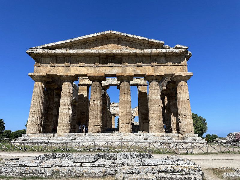
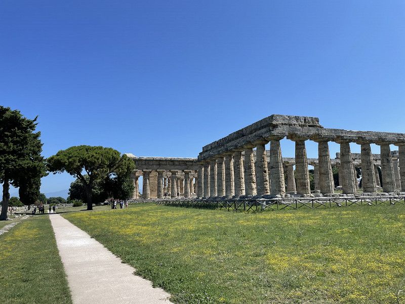
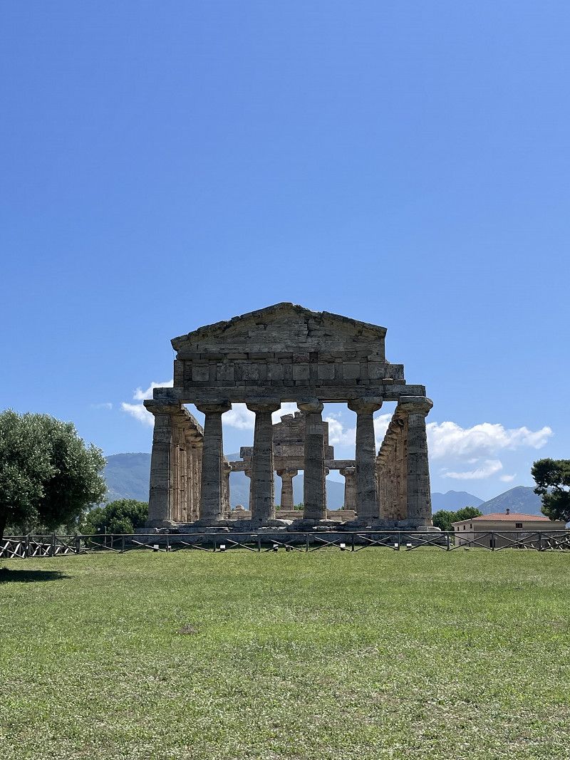
Paestum, Salerno, Italien
An absolute must for lovers of Greek and Roman culture and buildings. You should definitely take your time (and sun protection and enough water) for the cultural sites. We walked through the facility for over 2 hours and bought an information booklet at the entrance.
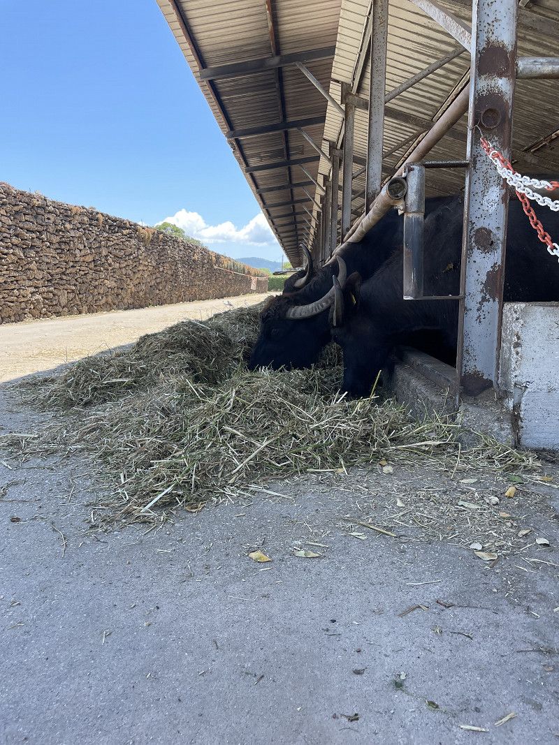
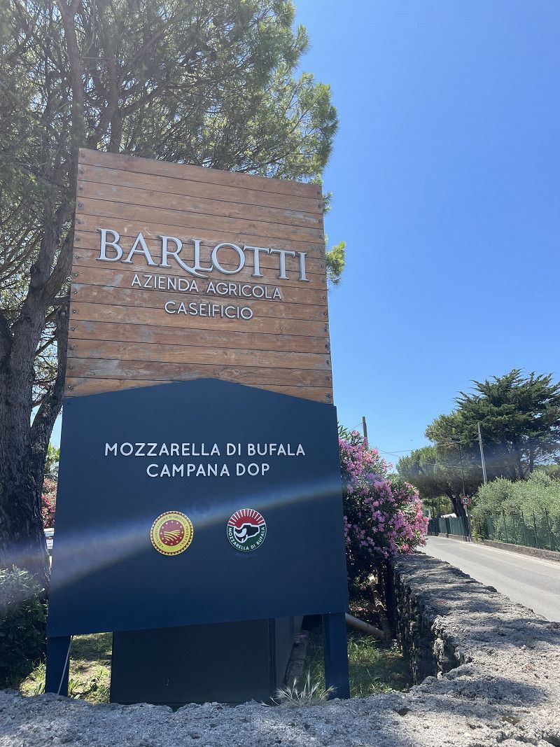
Another highlight of the area is the buffalo mozzarello. Corresponding farms can be visited in Paestum.
84047 Paestum, Salerno, Italien
40° 25' 23.3" N 15° 0' 25.8" E
40.4231513 15.0071628
• Head north on Via Magna Grecia. Go for 329 m.
• Turn right onto Via Porta Aurea (SP276). Go for 1.1 km.
• Continue on Via Porta Giustizia. Go for 1.1 km.
• Continue on Via Nettuno (SP189). Go for 290 m.
• Turn left onto Via Licinella (SP278). Go for 4.0 km.
• Continue on SP278. Go for 700 m.
• Continue on Via Litoranea di Paestum (SP278). Go for 829 m.
• Continue on SP278. Go for 5 m.
• Take the 1st exit from roundabout onto SS267. Go for 72 m.
• Continue on Via San Marco (SS267). Go for 1.4 km.
• Continue on Viale Risorgimento (SS267). Go for 659 m.
• Continue on Via Alcide De Gasperi (SS267). Go for 303 m.
• Continue on Via Piave (SS267). Go for 182 m.
• Turn left onto Via Duca Sanfelice (SS267). Go for 45 m.
• Turn right onto Viale Europa (SS267). Go for 111 m.
• Turn left onto Via San Pio X (SS267). Go for 194 m.
• Arrive at Via San Pio X (SS267). Your destination is on the right.
☍
11,3 km
( 17 min.)
Day
Agropoli, Salerno, Italien
We visited the village, about 10 km from the campsite, by bike. A nice coastal town with an imposing castle.
84043 Agropoli, Salerno, Italien
40° 20' 55.3" N 14° 59' 28.4" E
40.3486827 14.9912195
• Head southeast on Via San Pio X (SS267). Go for 18 m.
• Turn left onto Via Cristoforo Colombo. Go for 146 m.
• Take the 1st exit from roundabout onto Via Taverne. Go for 185 m.
• Take the 1st exit from roundabout onto Via Taverne. Go for 102 m.
• Turn left onto Via della Libertà. Go for 334 m.
• Turn left onto Via Alcide De Gasperi. Go for 114 m.
• Turn right onto Viale Risorgimento (SS267). Go for 645 m.
• Continue on Via San Marco (SS267). Go for 1.4 km.
• Continue on SS267. Go for 59 m.
• Take the 1st exit from roundabout onto SS267. Go for 332 m.
• Take the 2nd exit from roundabout toward Salerno/A3. Go for 337 m.
• Continue on Strada Provinciale Variante SS18 (SP430). Go for 3.8 km.
• Continue on Strada Statale Tirrena Inferiore (SS18). Go for 7.5 km.
• Pass 3 roundabouts and continue on Viale Eburum (SS18). Go for 9.4 km.
• Take the 1st exit from roundabout onto Località Cioffi (SS18) toward A3/Reggio Calabria/Salerno/Battipaglia. Go for 1.5 km.
• Pass 5 roundabouts and continue on Strada Statale Tirrena Inferiore (SS18). Go for 4.7 km.
• Take the 2nd exit from roundabout onto Strada Statale Tirrena Inferiore (SS18) toward Salerno/A3/Reggio C. Go for 287 m.
• Pass 2 roundabouts and continue on Strada Statale Tirrena Inferiore (SS18). Go for 1.0 km.
• Take left ramp onto A2 (Autostrada del Mediterraneo) toward Salerno. Go for 21.2 km.
• Take the exit toward Roma/A30/Avellino/Caserta onto A2 (Autostrada del Mediterraneo). Go for 8.8 km.
• Keep left onto A30 (Autostrada Caserta-Salerno) toward Caserta/Roma/A1. Go for 24.5 km.
• Take the exit toward Palma Campania. Go for 1.9 km.
• Take ramp onto Strada Statale del Vesuvio (SS268) toward Napoli/Ottaviano. Go for 3.4 km.
• Take ramp toward Ottaviano/San Gennaro Vesuviano. Go for 270 m.
• Turn right onto Via Ferrovie dello Stato. Go for 979 m.
• Turn left onto Viale Cimitero. Go for 264 m.
• Take the 1st exit from roundabout onto Via Vecchia Sarno. Go for 504 m.
• Turn left onto Via San Leonardo. Go for 582 m.
• Turn right onto Via Zabatta. Go for 1.9 km.
• Continue on Via Provinciale San Leonardo Zabatta. Go for 188 m.
• Turn right onto Via Profica Paliata. Go for 211 m.
• Arrive at Via Profica Paliata. Your destination is on the left.
☍
96,5 km
(1 hrs. 14 min.)
Day
CP Vesuvio Eco Camping
After an adventurous journey, we discovered that there is one place for tents and one for mobile homes. Both places are about 9km apart.
Of course, we promptly got hold of the one for tents and were allowed to leave again. We then saved ourselves the trip to second place and headed towards Rome. As we all know, all roads lead here.
Via Profica Paliata, 80047 San Giuseppe NA, Italien
40° 49' 36.3" N 14° 29' 7.4" E
40.8267395 14.4853900
• Head west on Via Profica Paliata.
• Turn right onto Traversa Alveo Falangone. Go for 54 m.
• Turn right onto Traversa Alveo Falangone. Go for 294 m.
• Turn left onto Via San Leonardo Zabatta. Go for 548 m.
• Turn right onto Via Scopari. Go for 854 m.
• Continue on Via Aielli. Go for 1.1 km.
• Turn slightly left onto Via del Premio. Go for 101 m.
• Turn right onto Via Capocresti. Go for 434 m.
• Continue on Via Martiri di Nassirya. Go for 303 m.
• Continue on Via Nuova Poggiomarino. Go for 1.3 km.
• Take ramp onto Strada Statale del Vesuvio (SS268) toward Caserta/A30/Salerno/Napoli/Nola/Pomigliano/Ottaviano. Go for 2.7 km.
• Take ramp toward Caserta-Salerno/A30. Go for 1.3 km.
• Take ramp onto A30 (Autostrada Caserta-Salerno) toward Roma/A1/E45/Caserta. Go for 30.8 km.
• Take the exit toward Roma/E45/Caserta Nord onto A1 (Autostrada del Sole). Go for 97.0 km.
• Take the exit toward Ceprano. Go for 870 m.
• Take the 3rd exit from roundabout onto Via Caragno (SP16) toward Arpino/Falvaterra/Monte S. Giovanni/Campano/Arce/Itri. Go for 245 m.
• Continue on Via Caragno (SP16). Go for 1.6 km.
• Take the 3rd exit from roundabout onto Via Caragno toward Pico/S.Giovanni Incarico. Go for 248 m.
• Continue on Via Vittorio Alfieri. Go for 210 m.
• Turn slightly right onto Via Riviera Liri. Go for 397 m.
• Continue on Piazza Camillo Benso di Cavour. Go for 64 m.
• Continue on Via Ponte Canale. Go for 144 m.
• Continue toward Strada Regionale Valle del Liri/SR82. Go for 26 m.
• Take the 1st exit from roundabout. Go for 31 m.
• Continue on Strada Regionale Valle del Liri (SR82). Go for 3.9 km.
• Continue on Strada Regionale Valle del Liri (SR82). Go for 962 m.
• Arrive at Strada Regionale Valle del Liri (SR82).
☍
145,6 km
(1 hrs. 21 min.)
Area Verde Puntolago
A truly hidden parking space with a lot of natural charm. For 15 €/ N without electricity but ok.
Via Civita, 03028, San Giovanni Incarico, Italien
41° 30' 57" N 13° 33' 19" E
41.5158333 13.5552778
• Head toward Via Civita on Strada Regionale Valle del Liri (SR82). Go for 1.3 km.
• Continue on Strada Regionale Valle del Liri (SR82). Go for 3.7 km.
• Take the 2nd exit from roundabout onto Via Ponte Canale. Go for 202 m.
• Turn right onto Via Vincenzo Gioberti. Go for 166 m.
• Continue on Piazza Guglielmo Marconi. Go for 48 m.
• Continue on Piazza Guglielmo Marconi. Go for 16 m.
• Continue on Via Campidoglio. Go for 500 m.
• Turn left onto Via Aldo Moro (SP2). Go for 349 m.
• Take the 1st exit from roundabout onto Via Caragno (SP16) toward Roma/A1/Napoli. Go for 1.8 km.
• Take ramp onto A1 (Autostrada del Sole) toward Roma-Napoli/Roma. Go for 79.9 km.
• Take the exit toward Roma Centro/Grande Raccordo Anulare/Roma Est onto A24 (Autostrada dei Parchi). Go for 12.4 km.
• Take the exit toward Tiburtina/SS5 onto A90 (Grande Raccordo Anulare). Go for 12.1 km.
• Keep right toward Castel Giubileo/Flaminia/SS3/Roma Centro/Tor di Quinto. Go for 1.4 km.
• Take the exit toward Roma Centro Tor di Quinto onto Variante Flaminia. Go for 524 m.
• Continue on Via Flaminia. Go for 2.2 km.
• Continue on Via Flaminia Nuova. Go for 654 m.
• Keep left onto Via Flaminia Nuova toward Flaminio/Corso di Francia. Go for 383 m.
• Arrive at Via Flaminia Nuova. Your destination is on the right.
☍
117,5 km
(1 hrs. 6 min.)
Day
Village Camping Flaminio
Already in 2008 we were on this square to visit Rome. At that time we took the train from the nearby train station to the city. This time we dared the trip by bike. A good undertaking in itself, once you have reached the cycle path along the Tiber. Until then, it's an adventure on highways.
In Rome itself you hardly meet any cyclists. Nevertheless, we found it very comfortable to cycle from sight to sight.
The CP has a swimming pool and very good sanitary facilities. We still got the last day of the ACSI discount - with 23 €/N plus visitor's tax a cheap stay.
Via Flaminia Nuova 821, 00189, Roma, Italien
41° 57' 24" N 12° 28' 60" E
41.9566700 12.4833300
• Head southwest on Via Flaminia Nuova. Go for 1.6 km.
• Turn slightly left onto Via Cassia Nuova. Go for 55 m.
• Continue on Corso di Francia. Go for 1.2 km.
• Continue on Ponte Flaminio. Go for 229 m.
• Continue on Corso di Francia. Go for 803 m.
• Take ramp onto Viale Maresciallo Pilsudski. Go for 450 m.
• Continue on Piazzale Manila. Go for 132 m.
• Continue on Via Cesare Fracassini toward Lungotevere/C.so d'Italia/Centro. Go for 180 m.
• Turn left onto Largo Antonio Sarti toward Centro. Go for 31 m.
• Turn left onto Lungotevere Flaminio. Go for 510 m.
• Continue toward Piazzale delle Belle Arti. Go for 36 m.
• Turn right onto Ponte del Risorgimento. Go for 141 m.
• Turn left onto Piazza Monte Grappa. Go for 86 m.
• Continue on Lungotevere delle Armi. Go for 411 m.
• Continue on Lungotevere Michelangelo. Go for 557 m.
• Continue on Lungotevere dei Mellini toward Trastevere/Eur. Go for 540 m.
• Continue on Lungotevere Prati. Go for 198 m.
• Continue on Piazza dei Tribunali. Go for 21 m.
• Keep right onto Piazza dei Tribunali. Go for 176 m.
• Continue on Via Triboniano. Go for 175 m.
• Continue on Piazza Adriana. Go for 584 m.
• Continue on Piazza Pia. Go for 91 m.
• Continue on Largo Giovanni XXIII. Go for 47 m.
• Continue on Lungotevere Vaticano. Go for 8 m.
• Keep right onto Sottopasso Castel Sant'Angelo. Go for 273 m.
• Keep left onto Sottopasso Castel Sant'Angelo. Go for 131 m.
• Continue on Lungotevere Gianicolense. Go for 403 m.
• Continue on Lungotevere della Farnesina. Go for 567 m.
• Continue on Lungotevere Raffaello Sanzio. Go for 414 m.
• Continue on Lungotevere degli Anguillara toward L'Aquila/A24/Napoli/A1. Go for 235 m.
• Continue on Lungotevere degli Alberteschi. Go for 64 m.
• Keep left onto Ponte Palatino. Go for 231 m.
• Continue on Lungotevere dei Pierleoni. Go for 161 m.
• Turn right onto Via del Foro Olitorio. Go for 93 m.
• Turn right onto Via Luigi Petroselli. Go for 333 m.
• Turn right onto Largo Amerigo Petrucci. Go for 84 m.
• Turn right onto Lungotevere Aventino. Go for 71 m.
• Turn right onto Via di Ponte Rotto. Go for 76 m.
• Turn left onto Via Luigi Petroselli. Go for 150 m.
• Continue on Via del Teatro di Marcello. Go for 379 m.
• Arrive at Via del Teatro di Marcello.
☍
11,9 km
( 17 min.)
Rom
One could now write endless essays about this great city. I think if you are planning a visit, you should inform yourself accordingly beforehand. We drove to the main sights and - as already described - explored them by bike. I would do this again and again, since it was very convenient not to have to walk far.
Oh yes, at the Trevi Fountain we ate 2 ice creams (one or 2 scoops each) for 16€. We then saved ourselves the obligatory coin toss in the fountain. 😉
Roma Capitale, Latium, Italien
41° 53' 36" N 12° 28' 58.6" E
41.8933203 12.4829321
• Head toward Piazza d'Aracoeli on Via del Teatro di Marcello. Go for 158 m.
• Turn left onto Via di San Marco. Go for 76 m.
• Continue on Via di San Venanzio. Go for 70 m.
• Continue on Piazza d'Aracoeli. Go for 65 m.
• Turn right onto Via del Teatro di Marcello. Go for 403 m.
• Turn right onto Via del Foro Olitorio. Go for 93 m.
• Turn right onto Lungotevere dei Pierleoni. Go for 111 m.
• Continue on Lungotevere de' Cenci. Go for 345 m.
• Continue on Lungotevere dei Vallati. Go for 304 m.
• Continue on Piazza San Vincenzo Pallotti. Go for 6 m.
• Continue on Lungotevere dei Tebaldi. Go for 570 m.
• Continue on Lungotevere dei Sangallo. Go for 426 m.
• Continue on Lungotevere dei Fiorentini. Go for 117 m.
• Turn left onto Ponte Vittorio Emanuele II. Go for 125 m.
• Turn left onto Lungotevere in Sassia. Go for 234 m.
• Turn right onto Piazza della Rovere. Go for 12 m.
• Keep left toward Galleria Principe Amedeo Savoia Aosta. Go for 146 m.
• Continue on Galleria Principe Amedeo Savoia Aosta. Go for 743 m.
• Continue on Piazzale Gregorio VII. Go for 84 m.
• Continue on Via Gregorio VII. Go for 2.2 km.
• Continue on Piazza di Villa Carpegna. Go for 10 m.
• Keep left onto Piazza di Villa Carpegna toward Via Aurelia Antica. Go for 74 m.
• Continue on Circonvallazione Aurelia. Go for 224 m.
• Turn left onto Piazza San Giovanni Battista de La Salle toward G.R.A./SS1/Aurelia. Go for 155 m.
• Continue on Via Aurelia. Go for 19.9 km.
• Take ramp onto A12 (Autostrada Azzurra) toward Civitavecchia. Go for 65.6 km.
• Continue on Via Aurelia (SS1). Go for 14.5 km.
• Take ramp toward Ischia di C./Manciano/Vulci/Saturnia. Go for 215 m.
• Continue on Strada Provinciale del Fiora (SP105). Go for 9.1 km.
• Turn left toward Strada Provinciale Campigliola/SP67. Go for 557 m.
• Continue on Strada Provinciale Campigliola (SP67). Go for 20.9 km.
• Turn sharp left onto Strada Provinciale Manciano Farnese (SP32). Go for 2.2 km.
• Turn right onto Via Martiri della Libertà. Go for 573 m.
• Take the 2nd exit from roundabout onto Via dell'Imposto (SR74). Go for 264 m.
• Take the 2nd exit from roundabout onto Via Padre Pascucci (SP159). Go for 6.5 km.
• Turn right onto Strada Provinciale Follonata (SP10). Go for 5.1 km.
• Turn left onto Strada Vicinale della Peschiera. Go for 1.4 km.
• Turn right onto Strada Vicinale della Peschiera. Go for 271 m.
• Arrive at Strada Vicinale della Peschiera.
☍
153,8 km
(1 hrs. 53 min.)
Day
Stellplatz Saturnia
Conveniently located and beautiful pitch with little shade to visit the warm bathing pools of Saturnia. Clean sanitary facilities. A cheap place to stay for 17€/N. At the entrance you take a ticket and when you leave you can pay the friendly cashier.
It takes about 10 minutes to walk to the thermal baths. The path goes through the adjacent fields. At the back end of the car park there is a separate exit to get on the road.
Strada Vicinale della Peschiera, 58010, Manciano, Italien
42° 39' 39" N 11° 29' 50.3" E
42.6608295 11.4973020
• Head northeast on Strada Vicinale della Peschiera. Go for 235 m.
• Continue on Località Fontebuia. Go for 756 m.
• Continue on Piazza Benvenuto di Giovanni. Go for 40 m.
• Turn slightly right onto Piazzale Benvenuto di Giovanni. Go for 27 m.
• Continue on Via della Chiesa. Go for 147 m.
• Arrive at Via della Chiesa.
☍
1,2 km
( 3 min.)
Saturnia, Grosseto, Italien
It is best to go to the thermal baths early in the morning. Then the rush is still manageable and you can usually enjoy your own natural bathtub alone. Admission is free and you can even take your dog with you.
58014 Saturnia, Grosseto, Italien
42° 39' 47.6" N 11° 30' 15.4" E
42.6632327 11.5042774
• Head east on Via della Chiesa.
• Turn slightly left onto Via Italia. Go for 737 m.
• Turn left toward Strada Provinciale Follonata/SP10. Go for 152 m.
• Turn right onto Strada Provinciale Follonata (SP10). Go for 6.6 km.
• Turn right onto Strada Provinciale Scansanese (SP159). Go for 19.6 km.
• Take the 2nd exit from roundabout onto Strada Provinciale Amiatina (SP160). Go for 419 m.
• Turn right. Go for 502 m.
• Turn left toward Strada Comunale del Saragiolo. Go for 45 m.
• Turn left onto Strada Comunale del Saragiolo. Go for 1.3 km.
• Continue straight ahead. Go for 36 m.
• Take the 1st exit from roundabout. Go for 49 m.
• Continue on Strada Provinciale Scansanese (SP159). Go for 21.3 km.
• Turn right onto Via dei Laghi (SP42). Go for 4.7 km.
• Turn right onto Via Batignanese. Go for 57 m.
• Continue on Via Rosellana. Go for 25 m.
• Continue on Via Batignanese. Go for 1.8 km.
• Continue on Via Batignanese Canonica. Go for 233 m.
• Turn left and take ramp onto Strada di Grande Comunicazione Grosseto-Fano (SS223) toward Siena. Go for 51.1 km.
• Take the 2nd exit from roundabout onto Strada di Grande Comunicazione Grosseto-Fano (SS223) toward A1/Autostrada/Siena. Go for 10.4 km.
• Take left ramp onto Circonvallazione Nuova toward Siena Centro/Bologna/A1/Firenze. Go for 18.2 km.
• Take ramp toward Monteriggioni. Go for 340 m.
• Turn slightly left onto Strada Regionale Cassia (SR2) toward Monteriggioni/Zona Industriale Casone. Go for 222 m.
• Take the 3rd exit from roundabout onto Strada Regionale Cassia (SR2) toward Monteriggioni/Siena. Go for 1.2 km.
• Turn sharp left onto Strada di Monteriggioni. Go for 250 m.
• Arrive at Strada di Monteriggioni. Your destination is on the left.
☍
139,3 km
(1 hrs. 52 min.)
Day
Area del Cipressino
Very good pitch with all supply and disposal functions including electricity for €16/N. Payment is made at a machine.
5 minutes walk to Monteriggione. The place offers real Tuscan atmosphere without the hustle and bustle and is a real alternative to Siena.
Strada di Monteriggioni, 53035, Monteriggioni, Italien
43° 23' 16" N 11° 13' 30" E
43.3877778 11.2250000
• Head toward Strada Regionale Cassia on Strada di Monteriggioni. Go for 250 m.
• Turn sharp right onto Strada Regionale Cassia (SR2). Go for 1.1 km.
• Take the 1st exit from roundabout onto Strada Regionale Cassia (SR2). Go for 192 m.
• Take ramp onto Superstrada Firenze-Siena (RA3) toward Firenze. Go for 8.0 km.
• Take ramp toward Colle Val d'Elsa Nord. Go for 219 m.
• Take the 3rd exit from roundabout toward Ospedale/Volterra/Colle Val d'Elsa. Go for 251 m.
• Take the 1st exit from roundabout onto Strada Regionale di Val di Cecina (SR68) toward Ospedale/Poggibonsi. Go for 2.6 km.
• Take the 3rd exit from roundabout onto Strada Regionale di Val di Cecina (SR68) toward San Gimignano/SP8. Go for 228 m.
• Turn right onto Strada Provinciale di San Lucchese (SP44). Go for 1.8 km.
• Continue on Via Santa Caterina. Go for 239 m.
• Turn left onto Via San Gimignano. Go for 219 m.
• Take the 2nd exit from roundabout onto Via San Gimignano. Go for 834 m.
• Continue on Strada Provinciale di San Gimignano (SP1). Go for 293 m.
• Take the 2nd exit from roundabout onto Strada Provinciale di San Gimignano (SP1) toward Volterra/SR68/San Gimignano/Ulignano/Cusona. Go for 155 m.
• Pass 4 roundabouts and continue on Via Roma (SP1). Go for 8.8 km.
• Turn right onto Via Bonda. Go for 191 m.
• Turn slightly left onto Via Bonda. Go for 33 m.
• Turn right onto Via Piandornella. Go for 42 m.
• Turn left onto Via delle Fosse. Go for 49 m.
• Turn left onto Via Palestro. Go for 60 m.
• Turn right onto Via San Giovanni. Go for 17 m.
• Continue on Piazza Cisterna. Go for 32 m.
• Turn slightly left onto Via San Matteo. Go for 34 m.
• Turn left onto Piazza Duomo. Go for 28 m.
• Arrive at Piazza Duomo. Your destination is on the right.
☍
25,6 km
( 27 min.)
Day
San Gimignano, Italien
We made a stopover in San Gimignano and treated ourselves to the famous ice cream for breakfast. When traveling to Tuscany, this place is an absolute must. This is also shown by the many groups of visitors who meander through the city with guidebooks.
By the way, we parked for free in a parking lot (see park4night). It was about a 10 minute walk uphill to downtown.
43° 28' 4.1" N 11° 2' 35.6" E
43.4677993 11.0432115
• Head north on Piazza Duomo. Go for 5 m.
• Turn left onto Piazza Duomo. Go for 18 m.
• Turn left onto Via Bucignana. Go for 91 m.
• Turn left onto Via Quercecchio. Go for 22 m.
• Turn left onto Via San Giovanni. Go for 9 m.
• Turn right onto Via Palestro. Go for 43 m.
• Turn right onto Via del Corbizzo. Go for 63 m.
• Turn right onto Via Piandornella. Go for 26 m.
• Turn left onto Via Bonda. Go for 224 m.
• Turn right onto Strada Provinciale di San Gimignano (SP1). Go for 74 m.
• Turn left onto Strada Provinciale di San Gimignano (SP1). Go for 141 m.
• Turn sharp right onto Via Roma (SP1). Go for 349 m.
• Take the 2nd exit from roundabout onto Strada Provinciale di San Gimignano (SP1) toward Racc. Si-Fi/SP2/Poggibonsi/A1/Colle di Val d'Elsa. Go for 3.9 km.
• Keep left onto Strada Provinciale di San Gimignano (SP1) toward Poggibonsi. Go for 2.5 km.
• Take the 2nd exit from roundabout onto Località Fosci (SP1). Go for 965 m.
• Take the 3rd exit from roundabout onto Località Foci (SP1). Go for 1.0 km.
• Take the 1st exit from roundabout onto Strada Provinciale di San Gimignano (SP1) toward Centro/Empoli/SS423/Certaldo/Firenze-Siena. Go for 123 m.
• Take the 2nd exit from roundabout onto Via San Gimignano (SP1). Go for 733 m.
• Take the 3rd exit from roundabout onto Via San Gimignano (SP1). Go for 149 m.
• Continue on Strada Provinciale di S. Gimignano (SP63) toward Raccordo Si-Fi. Go for 22 m.
• Take the 4th exit from roundabout toward Raccordo Si-Fi/Raccordo. Go for 167 m.
• Continue on Strada Regionale Raccordo Drove (SR429bis). Go for 121 m.
• Take ramp onto Collegamento Siena-Firenze SS429 (SR429bis) toward Siena/Firenze. Go for 2.3 km.
• Continue toward Raccordo Siena-Firenze/Zona Industriale Pian dei Peschi. Go for 54 m.
• Take the 2nd exit from roundabout onto Superstrada Firenze-Siena (RA3) toward Zona Industriale Pian dei Peschi/Firenze. Go for 31.3 km.
• Keep left onto Superstrada Firenze-Siena (RA3) toward Autostrade/A1/A11/Impruneta/SR2/Tavarnuzze/Galluzzo. Go for 441 m.
• Take the 3rd exit from roundabout onto A1 (Autostrada del Sole) toward Bologna/Roma/Firenze/A11/Pisa Nord/Aeroporto A. Vespucci. Go for 34.1 km.
• Keep right onto A1var toward Bologna/Barberino. Go for 39.1 km.
• Continue on A1 (Autostrada del Sole). Go for 63.7 km.
• Take the exit toward Brennero onto A22 (Autostrada del Brennero). Go for 146 km.
• Take the exit toward Rovereto Sud/Lago di Garda Nord. Go for 980 m.
• Take the 4th exit from roundabout toward Mori/Riva D/G/Arco. Go for 297 m.
• Continue on SS240. Go for 6.2 km.
• Pass 2 roundabouts and continue on Strada Rivana (SS240). Go for 5.1 km.
• Take the 4th exit from roundabout onto Strada Statale di Loppio e Val di Ledro (SS240) toward Torbole/Riva del Garda. Go for 2.0 km.
• Take the 1st exit from roundabout onto Via Giacomo Matteotti (SS240) toward Arco/SS249/Limone S/G./SS45. Go for 310 m.
• Turn left onto Via al Cor. Go for 102 m.
• Turn right onto Via al Cor. Go for 52 m.
• Arrive at Via al Cor. Your destination is on the left.
☍
343,0 km
(3 hrs. 20 min.)
Camper Stop Torbole
On the return trip we decided to go back to our surfing area at Lake Garda from the past days. We chose the Camper Stop Torbole as our pitch. Taking into account the development of the place and the well-known "Lake Garda bonus", the 38€/N was fine, even if it was the highest amount on our trip for an overnight stay.
38069, Torbole sul Garda, Italien
45° 52' 21.3" N 10° 52' 21.7" E
45.8725900 10.8727000
• Head southeast on Via al Cor. Go for 52 m.
• Turn left onto Via al Cor. Go for 102 m.
• Turn left onto Via Giacomo Matteotti (SS240). Go for 457 m.
• Take the 1st exit from roundabout onto Via Linfano (SS249). Go for 3.8 km.
• Continue toward Via Mantova. Go for 54 m.
• Take the 2nd exit from roundabout onto Via Mantova toward Arco Centro. Go for 887 m.
• Continue on Viale delle Monache. Go for 304 m.
• Turn right onto Via San Pietro (SS45bis). Go for 44 m.
• Take the 4th exit from roundabout onto Via San Pietro (SS45bis). Go for 380 m.
• Turn right onto Via Cesare Battisti (SP36) toward Ospedale/Ceole/Varignano/Vigne/Chiarano/Laghi. Go for 175 m.
• Turn slightly right onto Via Porta Scaria. Go for 112 m.
• Turn left onto Largo Pina. Go for 36 m.
• Continue on Via Fossa Grande. Go for 268 m.
• Turn slightly left toward Via del Calvario. Go for 55 m.
• Turn right onto Via del Calvario. Go for 349 m.
• Turn sharp right. Go for 146 m.
• Arrive at your destination.
☍
7,2 km
( 12 min.)
Day
Burgruine Arco, Via Castello, Arco, Autonome Provinz Trient, Italien
From the CP we did a bike ride to the Arco castle ruins. Thanks to electrical support, we drove all the way up to the castle. We were rewarded with a great view of Riva and Torbole.
Via Castello, 38062 Arco TN, Italien
45° 55' 18.4" N 10° 53' 16.6" E
45.9217747 10.8879400
• Head toward Via del Calvario. Go for 146 m.
• Turn slightly right onto Via del Calvario. Go for 618 m.
• Continue on Località Laghel. Go for 111 m.
• Turn left. Go for 77 m.
• Make a U-Turn. Go for 77 m.
• Turn right onto Località Laghel. Go for 111 m.
• Continue on Via del Calvario. Go for 767 m.
• Turn left toward Via Fossa Grande. Go for 55 m.
• Turn slightly right onto Via Fossa Grande. Go for 268 m.
• Continue on Largo Pina. Go for 36 m.
• Turn right onto Via Porta Scaria. Go for 112 m.
• Turn slightly left onto Largo Arciduca Alberto d'Asburgo Lorena (SP36). Go for 175 m.
• Continue on Via Garberie (SS45bis). Go for 315 m.
• Take the 2nd exit from roundabout onto Via Santa Caterina (SS45bis). Go for 794 m.
• Take the 3rd exit from roundabout onto Via Grande Circonvallazione toward Brennero/A22/Modena/Rovereto/SS240/Trento/SS45bis/Verona. Go for 617 m.
• Continue toward Verona/Torbole/Zona Industriale Linfano. Go for 36 m.
• Take the 2nd exit from roundabout onto Via Linfano (SS249) toward Torbole/Verona/Zona Industriale Linfano. Go for 3.9 km.
• Take the 3rd exit from roundabout onto Via Gardesana (SS240) toward Torbole Centro/Autostrada/A22/Rovereto/Verona. Go for 506 m.
• Turn right onto Via al Cor. Go for 102 m.
• Turn right onto Via al Cor. Go for 52 m.
• Arrive at Via al Cor. Your destination is on the left.
☍
8,9 km
( 19 min.)
Day
Camper Stop Torbole
38069, Torbole sul Garda, Italien
45° 52' 21.3" N 10° 52' 21.7" E
45.8725900 10.8727000
• Head southeast on Via al Cor. Go for 52 m.
• Turn left onto Via al Cor. Go for 102 m.
• Turn right onto Via Giacomo Matteotti (SS240). Go for 295 m.
• Take the 2nd exit from roundabout onto Strada Statale di Loppio e Val di Ledro (SS240) toward Autostrada/A22/Nago/Rovereto. Go for 1.9 km.
• Pass 3 roundabouts and continue on Località Loppio (SS240). Go for 11.4 km.
• Keep right toward Brennero/Modena. Go for 192 m.
• Take ramp onto A22 (Autostrada del Brennero) toward Brennero/Trento. Go for 167 km.
• Continue on A13 (Brennerpass). Go for 31.7 km.
• Keep right onto A13 (Knoten Innsbruck-Berg Isel) toward Bregenz/Garmisch/Innsbruck-West. Go for 2.0 km.
• Continue on A12 (Inntal Autobahn). Go for 35.0 km.
• Take exit 113 toward Mötz/Reutte/Fernpass. Go for 333 m.
• Turn right onto Mötzer Landesstraße (L236). Go for 4.8 km.
• Take the 2nd exit from roundabout onto Mieminger Bundesstraße (B189) toward Reutte/Fernpaß/Nassereith. Go for 13.4 km.
• Keep left onto Mieminger Bundesstraße (B189) toward Reutte/Garmisch. Go for 91 m.
• Continue on Fernpass Bundesstraße (B179). Go for 49.2 km.
• Continue on Grenztunnel Füssen (A7). Go for 67.2 km.
• Take exit 129 toward Memmingen-Süd/Zentrum/Memmingen/B300. Go for 317 m.
• Continue on St2031 toward Memmingen/B300. Go for 1.6 km.
• Turn left onto Am Schanzmeister (St2031). Go for 1.2 km.
• Continue on Ebertring (St2031). Go for 551 m.
• Continue on Adenauerring (St2031). Go for 894 m.
• Continue on Schumacherring (St2013). Go for 455 m.
• Turn right onto Schlachthofstraße. Go for 117 m.
• Turn right onto Hemmerlestraße. Go for 151 m.
• Continue on Schlachthofstraße. Go for 33 m.
• Turn right. Go for 29 m.
• Arrive at your destination on the left.
☍
390,2 km
(4 hrs. 32 min.)
Stellplatz Memmingen
We have already approached this place several times. For 7 €/N without electricity and supply and disposal (to be paid separately), it offers a cheap place to stay. It takes about 10 minutes to walk to the beautiful city center. In the vicinity of the square you can go for a walk with the dog.
Of course, we also took the obligatory walk to Gefro the next morning.
Colmarer Straße/Hemmerlestraße, 87700, Memmingen, Deutschland
47° 59' 44" N 10° 10' 56" E
47.9955556 10.1822222
• Head toward Colmarer Straße. Go for 29 m.
• Turn left onto Schlachthofstraße. Go for 33 m.
• Continue on Hemmerlestraße. Go for 151 m.
• Turn left onto Schlachthofstraße. Go for 117 m.
• Turn left onto Schumacherring (St2013). Go for 444 m.
• Turn right onto Donaustraße (St2013). Go for 3.3 km.
• Take the 2nd exit from roundabout onto Heimertinger Straße (St2031). Go for 711 m.
• Turn right onto St2031. Go for 776 m.
• Take the 3rd exit from roundabout onto Egelseer Straße (B300) toward Füssen/Ulm/Biberach/Ochsenhausen. Go for 1.3 km.
• Take ramp onto A7 toward Ulm/Würzburg. Go for 49.2 km.
• Take exit 120 toward Stuttgart/Ulm onto A8. Go for 86.1 km.
• Take exit 52 toward S.-Möhringen-Ost onto B27. Go for 9.6 km.
• Turn right onto Konrad-Adenauer-Straße. Go for 428 m.
• Keep right onto Konrad-Adenauer-Straße. Go for 209 m.
• Make a U-Turn onto Konrad-Adenauer-Straße. Go for 353 m.
• Keep right onto Konrad-Adenauer-Straße. Go for 265 m.
• Turn slightly left. Go for 65 m.
• Arrive at your destination on the right.
☍
153,1 km
(1 hrs. 46 min.)
Day
Stuttgart, Deutschland
Here we used the last stopover to visit my wife's cousin.
48° 46' 33" N 9° 10' 58.6" E
48.7758459 9.1829321
• Head south on Charlottenplatz (B27). Go for 791 m.
• Make a U-Turn onto Hohenheimer Straße (B27). Go for 1.2 km.
• Take ramp onto Friedrichstraße (B27) toward Heilbronn/Ludwigsburg. Go for 3.9 km.
• Keep right onto Heilbronner Straße (B27). Go for 1.5 km.
• Take ramp onto B10/B27 toward A81/Gewerbegebiet Zuffenhausen. Go for 2.1 km.
• Take ramp onto B10 toward Vaihingen (Enz)/A81/Korntal/S-Neuwirtshaus/S-Stammheim/Gewerbegebiet Zuffenhausen. Go for 4.5 km.
• Take ramp onto A81 toward Heilbronn. Go for 37.7 km.
• Keep left onto Autobahnkreuz Weinsberg toward Mannheim/Heilbronn/Neckarsulm/A6. Go for 1.5 km.
• Continue on A6. Go for 84.5 km.
• Continue on A67 toward Hannover/Frankfurt/Köln/Darmstadt. Go for 35.1 km.
• Take the exit toward Köln/Wiesbaden/Mainz/Darmstadt onto A67. Go for 23.2 km.
• Take the left exit toward Köln/Wiesbaden onto A3. Go for 167 km.
• Continue on A3. Go for 47.1 km.
• Take exit 16 toward Essen onto A52. Go for 15.3 km.
• Take exit 29 toward Essen-Süd/Essen-Zentrum/E-Zentrum. Go for 846 m.
• Continue on Richard-Wagner-Straße (K14) toward E-Zentrum. Go for 2.1 km.
• Turn left. Go for 89 m.
• Continue toward Zentrum. Go for 5 m.
• Continue on I. Dellbrügge toward Zentrum. Go for 263 m.
• Turn right onto Theaterplatz. Go for 64 m.
• Turn right onto I. Hagen. Go for 80 m.
• Arrive at I. Hagen.
☍
428,6 km
(4 hrs. 2 min.)
Day
Essen, Deutschland
Summary of the trip:
It was a varied and highly interesting trip, with culture and sights in the foreground. Because of the weather and the on-site conditions (beaches and sea not comparable to Corsica or Sardinia), beach stays have only taken place occasionally. But this was also clear to us from the start and also not the goal of the trip
The road conditions in southern Italy were a drop of bitterness. The partly very small streets were mostly littered with holes and bumps. Combined with the inevitable increased attention for Italian drivers who want to overtake, the distances between our stops were a real challenge. Even the west coast of Corsica, on the other hand, was a coffee ride.
But that shouldn't deter you from making this trip. It was a great experience and places like Matera, Ostuni, Monteriggione, Polygnano, Paestum, Tropea, Lecce or or or... you don't forget so quickly.
51° 27' 20.3" N 7° 0' 41.6" E
51.4556432 7.0115552